GrandWalk Trail. Planning & Development Study Kent County, MI
|
|
|
- Jean Copeland
- 5 years ago
- Views:
Transcription


1 Urban & Regional Planning Program Michigan State University UP 494/894 Planning Practicum GrandWalk Trail Planning & Development Study Kent County, MI Nicole Carson, Bianca Cobarzan, Andrea Dewey, Lisa Ellis, Eric Fazzini, Leonard Powell, Nathan Powell Spring 2007
2 Introduction to GrandWalk Trail Study Clients Rick Chapla - The Right Place Inc. Carol Townsend - MSU Kent County Extension Project Purpose Develop and analyze a GrandWalk area community profile Identify challenges to planning and building a non-motorized trail and propose solutions to overcome them Propose an ideal route for a trail in relation to area characteristics Assess the impact of a trail on the community Propose an implementation strategy for a trail
3 GrandWalk Paper Practicum Topics Profile of GrandWalk History of GrandWalk Socio-economic and Business profile Land and infrastructure inventory Recreational Context and Planning Objectives Master/Recreation Plans and Policy Legal Requirements, Liability and Construction Standards Trail planning and construction challenges Parcel acquisition procedure Construction along an active railroad, next to water, at intersections Trail Standards and Materials Safety and Liability Concerns Case Studies Trail Impact on Property Value and Crime Case Studies Recommendations Trail location, phases of development, access points, amenities Estimated Cost of Parcel Acquisition Trail Financing Options Stakeholders
4 Questions to be Addressed 1. What is GrandWalk and how is the proposed trail a tool to redevelop the area? 2. What would be the benefit of building the trail? 3. What community support is available for building the trail? 4. What are the challenges of building the trail and how can they be overcome? 5. What is the proposed location of the trail? How would development be phased? What amenities could be included? 6. How could land be acquired and how much would it cost? 7. What are the next steps in trail development?
5 1. What is GrandWalk and how is the proposed trail a tool to redevelop the area? 2. What would be the benefit of building the trail? 3. What community support is available for building the trail? 4. What are the challenges of building the trail and how can they be overcome? 5. What is the proposed location of the trail? How would development be phased? What amenities could be included? 6. How could land be acquired and how much would it cost? 7. What are the next steps in trail development?

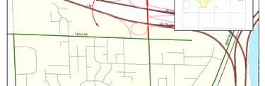

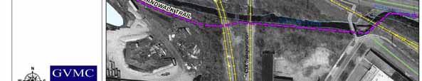
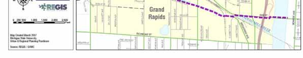
6 GrandWalk Boundaries


7 GrandWalk History Area settled in 1830s Historic industries: lumber, gypsum mining, oil, gravel pits and wagon construction First mill stones Public Museum of Grand Rapids Indian Mill Creek scrip labor
8 GrandWalk Socio-economic Profile Age distribution 1,833 acres 4812 residents Increasing number of young people/nearly 30% of population 32 years old - median age Low household size 2000 Median age GrandWalk Age 2000 % Change Under % 37.31% 5 to % 55.87% 10 to % 50.72% % 9.87% , % 19.76% , % 17.65% , % 39.20% % 28.18% % % Over % % GrandWalk Grand Rapids Household size GrandWalk Michigan % Change % % Walker 32.4 Kent County % Kent County 32.6 Grand Rapids % Michigan 35.5 Walker %
9 GrandWalk Socio-economic Profile Low median household income Median Household Income Change Low median housing value Low vacancy rate 16% of working population travel less than 10 min. to work $50,000 $40,000 $30,000 $20,000 $10,000 $0 $44,808 $45,983 $44,683 $36,673 $37,307 $29,325 $32,827 $32,358 $31,020 $26,809 GrandWalk Grand Rapids Walker Kent County Michigan and 2000 Median Housing Value $140,000 $120,000 $100,000 $91,600 $91,130 $117,670 $111,647 $110,257 $80,000 $60,000 $40,000 $53,300 $57,600 $71,500 $67,800 $60, Occupied and Vacant Housing Units $20,000 $0 GrandWalk Grand Rapids Walker Kent County Michigan Housing Units 2.3% 97.7% 6.1% 93.9% 4.3% 5.0% 95.7% 95.0% 10.6% 89.4% Vacant Housing Units Occupied Housing Units GrandWalk Grand Rapids Walker Kent County Michigan
10 GrandWalk Business Profile Approx. 380 businesses Distribution of Local Businesses by Size Small businesses 16% 12% 3% 2% 1 to 4 employees 5 to 9 employees 67% with less than 10 employees 52% with less than $249,000 sales volume 17% 50% 10 to 19 employees 20 to 49 employees 50 to 99 employees 100 to 499 employees 2005 Sales Volume 13% 6% 4% 3% 17% Less than $49,999 $50000 to $99,999 $100,000 to $249,000 $250,000 to $499,999 10% 11% $500,000 to $999,999 $1,000,000 to $1,999,999 12% 24% $2,000,000 to $4,999,999 $5,000,000 to $9,999,999 $10,000,000 to $55,000,000
11 GrandWalk Business Profile Major economic sectors: Manufacturing (36% of employees), Retail trade (13%), Wholesale trade (11%) and Services (8%) Strong economic sectors: - Building Materials Dealers - Non-store Retailers - Educational Services - Performing Arts - Spectator Sports - Waste Management - Rental and Leasing Services 4% 3%5% 5% 10.7% 11.4% 12.6% 13% GrandWalk Study Area Employment Breakdown by Sector, % 5% 11% 1% 9% 36% Grandwalk Study Area Establishment Count by Sector, % 8.5% 5.6% 9.9% 0.5% 3.9% 8.7% 24.7% Ag./Mining Construction Manufacturing Wholesale Trade Retail Trade TWI FIRE Professional Health Services Food services Ag./Mining Construction Manufacturing Wholesale Trade Retail Trade TWI FIRE Professional Health Services Food services Total establishment Count: 377

12 GrandWalk Business Profile


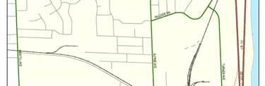
13 GrandWalk Zoning Map Proposed GrandWalk Trail - Heavy Industrial and Residential Areas


14 GrandWalk Business Profile Implications Large number of salvage yards adjacent to the proposed route of the trail Recreational and entertainment opportunities: DeltaPlex Theater, Richmond and Riverside Park Proximity to downtown Grand Rapids and Walker Opportunity for growth in trail tourism industry connection with existing trails

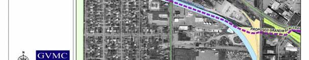
15 Proposed GrandWalk Trail Connections The Musketawa Trail

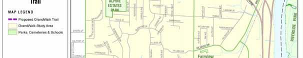


16 GrandWalk Parks and Schools
17 GrandWalk - Public Transportation Map Source: City of Grand Rapids Master Plan Bus Route Framework
18 1. What is GrandWalk and how is the proposed trail a tool to redevelop the area? 2. What would be the benefit of building the trail? 3. What community support is available for building the trail? 4. What are the challenges of building the trail and how can they be overcome? 5. What is the proposed location of the trail? How would development be phased? What amenities could be included? 6. How could land be acquired and how much would it cost? 7. What are the next steps in trail development?


19 Proposed GrandWalk Trail Benefits Recreation - access to, and link between Richmond and Riverside Parks Health - trails associated with decreased obesity rates Youth - education, exercise, safe school routes Enhancement of natural resources - Indian Mill Creek environmental awareness, salmon population Economic - area revitalization Transportation - non-motorized alternatives, connect two regional trail systems


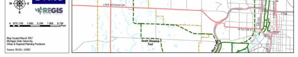
20 Greater GrandWalk Trail Map
21 1. What is GrandWalk and how is the proposed trail a tool to redevelop the area? 2. What would be the benefit of building the trail? 3. What community support is available for building the trail? 4. What are the challenges of building the trail and how can they be overcome? 5. What is the proposed location of the trail? How would development be phased? What amenities could be included? 6. How could land be acquired and how much would it cost? 7. What are the next steps in trail development?
22 Community Support Stakeholders Residents and Landowners alongside the proposed trail Community Organizations West Grand Neighborhood Organization Steepletown Youth Group Advocacy Groups Friends of Indian Mill Creek Friends of Walker Highland Trails Friends of White Pine Trail and Musketawa Trail Municipalities Grand Rapids and Walker Planning and Engineering Depts. Recreation Depts., Drain Commissioner Kent Co. Parks & Rec. Dept., DNR, MDOT West MI Strategic Alliance, West MI Trails and Greenways
23 Community Support City of Grand Rapids Plans Parks Plan Increase recreational benefits Encourage connectivity Linkages with parks system Walkability - lack of policy Master Plan Theme of Balanced Transportation Reduce auto dependency/ increase non-motorized trans. Preserve natural areas Increase mobility and access Community Support City of Walker Plans Parks Plan Explicit connections System of trails Multi-modal transportation Increase recreation Master Plan Neighborhood Section Neighborhood connectivity and "livability Neighborhoods - expanded recreational opportunities
24 Community Support Kent County Kent County Parks Plan MSU Recreation Needs Assessment Working Draft to be updated summer 2007 United Growth for Kent Co. Connect neighborhoods Encourage development that utilizes existing infrastructure Community Support West Michigan West MI Strategic Alliance 25 year-plan Integrate park access/green infrastructure into urban neighborhoods Trails & Greenways Coalition Goal: 510 miles of trail network
25 Community Support State State Long Range Plan Limited MDOT control of non-motorized facilities 1,428 mi. of trails 1st in Nation (2005) Transportation Enhancement Fund Land Use Leadership Council Encourage state-wide trail system Community Support Federal SAFETEA-LU - Transportation Legislation Increase inter-modal connectivity Streamline government $370 million through 2009 for recreational trails Safe Routes to School Encourage/Enable walking and biking to school
26 1. What is GrandWalk and how is the proposed trail a tool to redevelop the area? 2. What would be the benefit of building the trail? 3. What community support is available for building the trail? 4. What are the challenges of building the trail and how can they be overcome? 5. What is the proposed location of the trail? How would development be phased? What amenities could be included? 6. How could land be acquired and how much would it cost? 7. What are the next steps in trail development?

27 Proposed Trail Planning Challenges Property Owner Concerns Private Liability Concerns Impact on Crime Impact on Property Value Construction Challenges Intersection with Roadways Intersections with Railroads Adjacent to Water
28 Proposed Trail Planning Challenges Property Owner Concerns Private Liability Concerns Trespassing Noise Litter Impact on Crime Impact on Property Value
29 Proposed Trail Planning Challenges Private Liability Concerns Types of Property Owner Concern Trespassing Duty of Care Protections Recreational Use Statutes Michigan Natural Resource and Environmental Protection Act Easements Insurance Policies Conclusions No liability landowner liability adjacent to trail No need for landowner to purchase additional insurance
30 Proposed Trail Planning Challenges Impact on Crime Case Studies Omaha Recreational Trail, NE Pinellas Trail, FL Pere Marquette Trail, MI Conclusions No adverse impact on safety or security Crime rates not statistically different Sense of safety and security for trailside residents 50% 40% 30% 20% 10% 0% Very poor Poor OK Good Very good Mean Source: Pere Marquette Trail Case Study, Michigan State University
31 Proposed Trail Planning Challenges No effect 15% Impact on Property Value Case Studies Omaha Recreational Trail, NE Pinellas Trail, FL Pere Marquette Trail, MI Minuteman Bikeway and Nashua River Trail Run, MA Impact of Trails on Selling Home Don't know 18% More difficult to sell 2% Source: Omaha Recreational Trail Case Study Easier to sell 65% No effect 36% Impact of Trail on Selling Price Don't know 20% Decrease 2% Increase 42% Source: Omaha Recreational Trail Case Study Conclusions Majority residents felt no impact on value Many felt increased value Houses near trail sold twice as fast as other Positively influence purchase decision

32 Proposed Trail Planning Challenges Construction Challenges Intersection with Roadways Intersections with Railroads Adjacent to Water


33 Proposed Trail Planning Challenges Intersections with Roadways Intersections with Railroads


34 Proposed Trail Planning Challenges Intersections with Roadways Raised crosswalk or intersection Signage, crossing devices Refuge islands Overpass


35 Proposed Trail Planning Challenges Intersections with Railroads Easements not granted along active rail CSX Crossing a Railroad: Overpass Sunken At-grade


36 Proposed Trail Planning Challenges
37 Proposed Trail Planning Challenges Adjacent to Water Indian Mill Creek within study area, not a classified drain
38 1. What is GrandWalk and how is the proposed trail a tool to redevelop the area? 2. What would be the benefit of building the trail? 3. What community support is available for building the trail? 4. What are the challenges of building the trail and how can they be overcome? 5. What is the proposed location of the trail? How would development be phased? What amenities could be included? 6. How could land be acquired and how much would it cost? 7. What are the next steps in trail development?

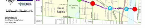
39 Proposed GrandWalk Trail Location Elements Considered for Locating the Trail 1. Safety 2. Cost 3. Existing Infrastructure 4. Connections with Other Trails 5. Trail Accommodations 6. Connections with Community
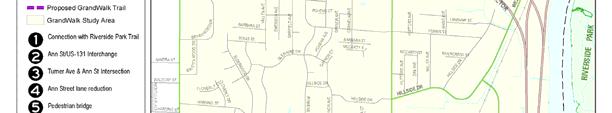
40 Proposed GrandWalk Trail Location Trail Length: 1.9 Miles
41 Proposed GrandWalk Trail Location Phase 1 Phase 1


42 Proposed GrandWalk Trail Location Phase 1
43 Proposed GrandWalk Trail Location Phase 1 Start: Southernmost point of Riverside Park - access point Cross to South side Ann at 131 exit - access with parking Intersection with Turner West along Ann St.- lane reduction
44 Proposed GrandWalk Trail Location Phase 1 Phase 1 cont. Cross over railroad/pedestrian bridge to south side Indian Mill Creek - access with parking Overpass three active railroad tracks


45 Proposed GrandWalk Trail Location Phase 2 Phase 2


46 Proposed GrandWalk Trail Location Phase 2

47 Proposed GrandWalk Trail Location Phase 2 Phase 2 Continue west on south banks of Indian Mill Creek Overpass intersection of Alpine - access point Continue along south side of Indian Mill Creek Reach Richmond Park access with recreation


48 Proposed GrandWalk Trail Overpasses Alpine Ave. Overpass Railroad Overpass


49 Proposed GrandWalk Trail Location Phase 3 Phase 3


50 Proposed GrandWalk Trail Location Phase 3
51 Proposed GrandWalk Trail Location Phase 3 Phase 3 Continue west on south side of Creek Cross over railroad trestle to north side of Creek Continue along abandoned rail corridor to Bristol


52 Proposed GrandWalk Trail Access Map Access Points Access and Parking Rest Areas


53 Proposed GrandWalk Trail Access Map
 Overlook Deck at")

54 Proposed GrandWalk Trail Amenities Informative Signs Mill Stones (Replica) Overlook Deck at Trestle Canoe Livery Benches Bike Racks Drinking Fountains Decorative Lighting Disposal Wastebaskets Emergency Boxes
55 1. What is GrandWalk and how is the proposed trail a tool to redevelop the area? 2. What would be the benefit of building the trail? 3. What community support is available for building the trail? 4. What are the challenges of building the trail and how can they be overcome? 5. What is the proposed location of the trail? How would development be phased? What amenities could be included? 6. How could land be acquired and how much would it cost? 7. What are the next steps in trail development?
56 GrandWalk Trail Parcel Acquisition Easement Three GR Eastern RR Inc. Consumers Energy Chesapeake and Ohio RR 5.35 acres total Purchase Six Penndel Co. (4) Conrail RR CL Frost Inc acres total Previously Owned One City of Grand Rapids 3.35 acres total
57 GrandWalk Trail Parcel Acquisition
58 GrandWalk Trail Parcel Acquisition Lower Cost Estimate Industrial - $1.50 per square foot Easement cost - 20% of total parcel value $1,539,813 Estimated total: $883,527 $883,527 Higher Cost Estimate Industrial - $2.50 per square foot Lower Cost Estimate Higher Cost Estimate Easement cost - 25% of total parcel value Estimated total: $1,539,813
59 1. What is GrandWalk and how is the proposed trail a tool to redevelop the area? 2. What would be the benefit of building the trail? 3. What community support is available for building the trail? 4. What are the challenges of building the trail and how can they be overcome? 5. What is the proposed location of the trail? How would development be phased? What amenities could be included? 6. How could land be acquired and how much would it cost? 7. What are the next steps in trail development?
60 GrandWalk Trail Next Steps 1. Feasibility Study information on property, environmental considerations, aesthetics, costs of alternative routes 2. Parcel Acquisition funding sources include private donations, municipal funds, Michigan Natural Resources Trust Fund 3. Engineering exact location, surveying, permits, grading and earth movements, environmental impacts, title issues, material and construction costs 4. Construction 5. Maintenance Cities of Grand Rapids and Walker, Friends of Trail groups
61 GrandWalk Trail Immediate Next Steps Pursue Feasibility Study - Apply for a Transportation Enhancement Grant from MDOT Continue to Garner Community/Stakeholder Support

62 Thank you for your attention! Questions?
GrandWalk Trail Planning & Development Study. Table of Contents
 Table of Contents Project Acknowledgments... 4 Table of Figures... 5 Table of Maps... 7 I. Executive Summary... 8 II. Introduction... 10 Client Information... 10 Purpose of the Project... 10 Report Content...
Committee. Presentation Outline
 CW-33-15 11/9/2015 Community and Corporate Services Committee November 10, 2015 1 Presentation Outline Background Vision and Objectives Study Process and Timeline Public and Stakeholder Engagement Organization
Predictive Economic Impact Study for the Mount Dora to Seminole Wekiva Trail
 Predictive Economic Impact Study for the Mount Dora to Seminole Wekiva Trail Prepared By: Valerie Seidel vseidel@balmoralgroup.us 341 N. Maitland Ave., Suite 100 Maitland, FL 32751 Phone (407) 629-2185
Airport Planning Area
 PLANNING AREA POLICIES l AIRPORT Airport Planning Area LOCATION AND CONTEXT The Airport Planning Area ( Airport area ) is a key part of Boise s economy and transportation network; it features a multi-purpose
City of Haslett. City of East Lansing. City of East Lansing
 Central Park North (Nancy L. Moore Park) Lake Park North Expansion White Park Expansion #2 White Park Expansion #1 County East East Haslett East East TF87-212 Acquisition $90,000.00 Park. TF08-138 Acquisition
CHAPTER ONE LITERATURE REVIEW
 CHAPTER ONE LITERATURE REVIEW LITERATURE REVIEW This chapter summarizes the most recently published community impact studies and articles that relate to multiuse trails. The review focuses on publications
N VANCOUVER AVE PARCEL
 FOR SALE N. VANCOUVER COMMERCIAL OPPORTUNITY - in - PORTLAND OREGON LILLIS ALBINA CITY PARK LEGACY EMANUEL MEDICAL CENTER LOCATED on N. Vancouver Ave 2839 SW 2nd Avenue Portland OR, 97201 503.222.1655
Georgetown-Lewes Rail/Trail Study. Rail/Trail Study: Cool Spring to Cape Henlopen State Park New Road Extension (House Resolution No.
 Georgetown-Lewes Rail/Trail Study Rail/Trail Study: Cool Spring to Cape Henlopen State Park New Road Extension (House Resolution No. 47) August 22, 2011 Presentation Outline Background Benefits Statewide
Chuckanut Ridge Fairhaven Highlands EIS Scoping Concerns
 Chuckanut Ridge Fairhaven Highlands EIS Scoping Concerns Coalition of Southside Neighborhoods CSN Comments for Fairhaven Highlands EIS Scope Hearing, Jan 16, 2008 1 Chuckanut Ridge Hilly Terrain: Potential
Coast to Coast Connector Summit
 Project Partners Welcome to the Coast to Coast Connector Summit Winter Garden, Florida City Hall October 1, 2014 1 Why are we here? Objectives 1. Inform key stakeholders on the current state of the C2C
2. Goals and Policies. The following are the adopted Parks and Trails Goals for Stillwater Township:
 D. PARKS AND TRAILS 1. Introduction Stillwater Township s population is relatively low, with most residents living on rural residences on large lots. The need for active park space has been minimal in
Gold Coast. Rapid Transit. Chapter twelve Social impact. Chapter content
 Gold Coast Rapid Transit Chapter twelve Social impact Chapter content Social impact assessment process...235 Existing community profile...237 Consultation...238 Social impacts and mitigation strategies...239
ORANGE COUNTY TRANSPORTATION AUTHORITY. Go Local Fixed-Guideway Program History and Project Update. PowerPoint 3
 ORANGE COUNTY TRANSPORTATION AUTHORITY Go Local Fixed-Guideway Program History and Project Update PowerPoint 3 Santa Ana-Garden Grove Fixed Guideway Project OCTA Board of Directors September 26, 2011 Project
DRAFT - APRIL 13, 2007 ROUTING STUDY FOR TRAIL CONNECTIONS BETWEEN CALAIS AND AYERS JUNCTION
 DRAFT - APRIL 13, 2007 ROUTING STUDY FOR TRAIL CONNECTIONS BETWEEN CALAIS AND AYERS JUNCTION Abstract The vision for the East Coast Greenway is an off-road urban trail system running from Calais, Maine
Northeast Quadrant Distinctive Features
 NORTHEAST QUADRANT Northeast Quadrant Distinctive Features LAND USE The Northeast Quadrant includes all the area within the planning area that is east of Interstate 5 and to the north of State Route 44.
PROPERTY INFORMATION PACKAGE: 412 Webster St
 C O M M U N I T Y D E V E L O P M E N T 4 0 0 B O A R D M A N A V E N U E T R A V E R S E C I T Y, M I 4 9 6 8 4 C O N T A C T : J E A N D E R E N Z Y 2 3 1. 9 2 2. 4 5 1 3 j d e r e n z y @ g r a n d
Blueways: Rivers, lakes, or streams with public access for recreation that includes fishing, nature observation, and opportunities for boating.
 Parks, Open Space and Trails PRINCE WILLIAM COUNTY 2008 COMPREHENSIVE PLAN TRAILS PLAN CONTENTS The components of the trails plan are: Intent Definitions Goals, Policies, and Action Strategies Trails Map
DEVELOPMENT OPPORTUNITY 630 Central Park Yonkers, NY 10704
 DEVELOPMENT OPPORTUNITY 630 Central Park Yonkers, NY 10704 1 Offering Memorandum 630 Central Park, Yonkers, NY 10704 +/-200,000 Square Feet Industrial Building Redevelopment Opportunity 630 Central Park
!" # $ % & % ' ( '' ) ) ) ) )
 ) ) ) )") !" #$% &% ' ( ')) ))) #% * % ) +#% *- *,% ) Trails Attract Business, Residents and Tourists National Association of Homebuilders 0% 20% 40% 60% % of What People Desired Exercise Facilities Proximity to
!" #$% &% ' ( ')) ))) #% * % ) +#% *- *,% ) Trails Attract Business, Residents and Tourists National Association of Homebuilders 0% 20% 40% 60% % of What People Desired Exercise Facilities Proximity to
ANCLOTE COASTAL TRAIL ALTERNATIVES ANALYSIS STUDY
 ANCLOTE COASTAL TRAIL ALTERNATIVES ANALYSIS STUDY PASCO COUNTY MPO JULY 2015 PROJECT OVERVIEW... INTRODUCTION EXECUTIVE SUMMARY CONTEXT... TAMPA BAY AREA, PINELLAS, & PASCO COUNTY S MULTI-USE TRAIL PLANS
Commercial Lots For Sale - Monrovia / Harvest Area
 CROSSROADS @ Research Park Blvd., AL 35806 BILL MING COMMERCIAL REAL ESTATE Project: Commercial Lots For Sale - Monrovia / Harvest Area CROSSROADS @ Research Park Blvd. Call for Pricing Location: Research
For Sale. LOCATED AT A SIGNALIZED HIGH-VOLUME INTERSECTION Hard Corner Main St. Warehouse Space. Main St.
 SEC & Highway SE For Sale Museum of Heritage & Arts 1 13 Sale Price See Advisor Available Land 1 13 Mission Ave: 2 135 Mission Ave: 3 103 Vallejos Ln. TOTAL: ±0.48 Acres ±0. Acres ±0.31 Acres ±1.104 Acres
THOMAS A. SWIFT METROPARK Introductions History Present Conditions Future Development Plans Implementation Strategies Statistics
 THOMAS A. SWIFT METROPARK Introductions History Present Conditions Future Development Plans Implementation Strategies Statistics Introduction As an open meadow park positioned along the Mahoning River,
Stage 2 ION: Light Rail Transit (LRT) from Kitchener to Cambridge
 from Kitchener to Cambridge") Stage 2 ION: Light Rail Transit (LRT) from Kitchener to Cambridge Public Consultation Centre (PCC) No. 3 Please Sign-in Cambridge City Hall November 21, 2017 2:00 to 8:00pm Preston Memorial Auditorium
Stage 2 ION: Light Rail Transit (LRT) from Kitchener to Cambridge Public Consultation Centre (PCC) No. 3 Please Sign-in Cambridge City Hall November 21, 2017 2:00 to 8:00pm Preston Memorial Auditorium
MUSIC CITY CENTER, NASHVILLE KAY BAILEY HUTCHINSON CONVENTION CENTER, DALLAS ALBANY CAPITAL CENTER
 MUSIC CITY CENTER, NASHVILLE Metro Government Project Type Feasibility, Economic Impact, Tax Projections Years of Service 2009 2013 HVS provided feasibility and economic impact studies for the Music City
Clackamas County Development Agency
 Clackamas County Development Agency Development Services Building, 150 Beavercreek Rd., Oregon City, OR 97045 www.clackamas.us/transportation/renewal 503-742-4323 The Clackamas County Board of Commissioners
DEVELOPMENT OPPORTUNITY 630 Central Park Yonkers, NY 10704
 DEVELOPMENT OPPORTUNITY 630 Central Park Yonkers, NY 10704 Cross County Shopping Mall 630 Central Park Empire City Casino and Race Track Yonkers 630 Central Park, Yonkers, NY 10704 2 Yonkers is located
Aviation, Rail, & Trucking 6-1
 6-1 This chapter describes the services, facilities, and condition of air, rail, and trucking as components of the transportation system. These three intermodal areas have an impact on the factors to be
METROPOLITAN COUNCIL 390 North Robert Street, St. Paul, MN Phone (651) TDD (651)
 TDD (651)") DATE: March 27, 2012 METROPOLITAN COUNCIL 390 North Robert Street, St. Paul, MN 55101 Phone (651) 602-1000 TDD (651) 291-0904 TO: Metropolitan Parks and Open Space Commission FROM: Arne Stefferud, Planning
DATE: March 27, 2012 METROPOLITAN COUNCIL 390 North Robert Street, St. Paul, MN 55101 Phone (651) 602-1000 TDD (651) 291-0904 TO: Metropolitan Parks and Open Space Commission FROM: Arne Stefferud, Planning
UNIVERSITY CITY TOMORROW S URBAN CENTER
 UNIVERSIT Y CIT Y TO M O R R O W S U R B A N C E N T E R ABOUT University City: Tomorrow s Urban Center University City is poised to begin a new chapter as the opening of Charlotte s LYNX Blue Line Extension
6. How connected do you feel to the Sans Souci community?
 Please complete and return before May 1st, 2017, to be entered for a prize drawing. Further instructions are available on the last page. Digital version available at GCPlanning.org. 1. Do you live and/or
Area Surrounding Maplewood Manor
 BAY CITY, MICHIGAN HOUSING COMMISSION Neighborhood Revitalization Plan Area Surrounding Maplewood Manor January 13, 2014 CITY COMMISSION DRAFT PLAN PRESENTATION BAY CITY, MICHIGAN 1 Planners Phil McKenna,
IL 390 Station. Wood Dale Open House Summary 5/18/17
 Wood Dale Open House Summary 5/18/17 The first public open house for the Wood Dale Comprehensive Plan took place on May 18 th, 2017. The program was conducted as a fun community event and there were 216
Yuba Creek Natural Area Acquisition. Acme Township. Acme Township. TF Acquisition $1,576, Grand Traverse
 Yuba Creek Natural Area TF00-162 $1,576,021.00 in fee simple of 403 acres of critical wetls upl habitat with over 5,000 feet of frontage on Yuba Creek, a tributary to the east arm of Bay. 2000 Petobago
4.0 Context for the Crossing Project
 4.0 Context for the Crossing Project This section provides background information about key features of the North Douglas Crossing project area, and opportunities and constraints. This information is important
CHAPTER 3 PLANNING GOALS
 CHAPTER 3 PLANNING GOALS AND PUBLIC INPUT INTRODUCTION This portion of the Algonac Master Plan is intended to outline a course for action in achieving the community s vision for the future. Throughout
REDEV ECOLONIAL GAS STATION
 REDEV ECOLONIAL GAS STATION 14266 E COLONIAL DR ORLANDO, FL 32826 Ali Mushtaq Senior Advisor 407.982.3976 ali.mushtaq@svn.com Mital Saraiya Advisor 386.566.2183 mital.saraiya@svn.com SVN FLORIDA COMMERCIAL
INGHAM COUNTY TRAILS AND PARKS TASK FORCE MEETING 2
 INGHAM COUNTY TRAILS AND PARKS TASK FORCE MEETING 2 October 22, 2015 Mannik and Smith Group Michigan Trails & Greenways Alliance AGENDA FOR TONIGHT 1. Project Approach, Process and Timeframe 2. Public
AGENDA ITEM 5 D WAKULLA ENVIRONMENTAL INSTITUTE (WEI) TRAIL FEASIBILITY STUDY
 TRAIL FEASIBILITY STUDY") March 19, 2018 AGENDA ITEM 5 D WAKULLA ENVIRONMENTAL INSTITUTE (WEI) TRAIL FEASIBILITY STUDY TYPE OF ITEM: Action STATEMENT OF ISSUE The Wakulla Environmental Institute (WEI) Trail is one of several trails
March 19, 2018 AGENDA ITEM 5 D WAKULLA ENVIRONMENTAL INSTITUTE (WEI) TRAIL FEASIBILITY STUDY TYPE OF ITEM: Action STATEMENT OF ISSUE The Wakulla Environmental Institute (WEI) Trail is one of several trails
ZoPath Trail. Extreme Park. Group III. Brendan Pillar, Conor Coakley James Amendola, & Mark McDermott. May 4, 2006
 ZoPath Trail & Extreme Park Group III Brendan Pillar, Conor Coakley James Amendola, & Mark McDermott May 4, 2006 HOW TO GET FROM THE TOWPATH S NORTHERN TRAILHEAD TO HERE? Bridging Two 1 st -Class Regional
Hillsborough County Florida Hillsborough County s Trailways Addressing Program
 Hillsborough County Florida Hillsborough County s 9-1-1 Trailways Addressing Program 2010 ProBike/ProWalk Florida -Conference May 12-13, 2010 1 REQUEST Staff from the Hillsborough County Sheriff s Office
For Sale. Income-Producing Investment 100% FULL! HIGH VISIBILITY ALONG HIGHWAY 314. Thalia Toha
 HIGH VISIBILITY ALONG HIGHWAY 959 Highway CPD 30,4 Starlight Cinema 1% FULL! For Sale Sale Price SWC Highway & Park Lane SW Municipal Court CP D2 8,3 $798,9 9.5% cap rate Available Katherine Gallegos ±5
MLS # $202, Acres residential development site in Bay County, Florida
 MLS # 617466 $202,000 35.31 Acres residential development site in Bay County, Florida Highway 231 Fountain, FL Presented By: Don Nations Nations Real Estate 2325-A Frankford Avenue, Suite A Panama City,
Non-Motorized Transportation
 Non-Motorized Transportation Non-motorized facilities are important components to the transportation system. They provide an environmentally-friendly, low-cost mode of travel. Some of the facilities can
Strengthening the Ontario Trails Strategy. Report on Consultations and the Environmental Bill of Rights Registry
 Strengthening the Ontario Trails Strategy Report on Consultations and the Environmental Bill of Rights Registry Purpose To report on the feedback and information received through the regional consultations,
PREDICTIVE ECONOMIC IMPACT ASSESSMENT FOR THE WEKIVA TRAIL IN DOWNTOWN MT DORA
 PREDICTIVE ECONOMIC IMPACT ASSESSMENT FOR THE WEKIVA TRAIL IN DOWNTOWN MT DORA L A K E - S U M T E R M P O C Y C L I N G S U M M I T M A R C H 2 7 T H 2015 C L E R M O N T C I T Y C E N T E R PROJECT OVERVIEW
Other Principle Arterials Minor Arterial Major Collector Minor Collector Local
 CHAPTER 10 TRANSPORTATION Introduction The system of public roads in East Pikeland Township is decidedly rural in character. Since the 1984, the road network has remained much the same, with the addition
Everett Riverwalk Life style explore
 Life style explore Project Overview The 217-acre Everett Riverfront redevelopment is visible from I-5 with traffic counts charted at 170,000+ vehicles per day with direct freeway access from 4-way interchange.
REAL ESTATE TRANSACTION ADVISORY SERVICES
 REAL ESTATE TRANSACTION ADVISORY SERVICES Improving Performance and Value of Amtrak-owned Assets AMTRAK STATION DEVELOPMENT 1 New York Penn Station Moynihan Train Hall Philadelphia 30 th Street Station
CAUSE FOR CELEBRATION!
 CAUSE FOR CELEBRATION! A LONG TIME COMING.. Council votes to keep rails-to-trails on track Opponents of trail take case to County Council Indiana Farm Bureau leads criticism of rail-to-trail land deals
3. COLTA / HUGA CONNECTIONS - PRELIMINARY
 9 3. COLTA / HUGA CONNECTIONS - PRELIMINARY 3.1 COLTA The Chain of Lakes Trail Association (COLTA) trail, formerly identified as the Chester Spur Line, was completed and opened for use in June 2011. The
447 Route 28 West Yarmouth MA 02673
 CAREY COMMERCIAL, INC. BUSINESS & INVESTMENT PROPERTY 146 MAIN STREET HYANNIS, MA 02601 for sale 2 ACRES OF COMMERCIAL LAND 447 Route 28 West Yarmouth MA 02673 Contact: Chuck Carey 508-790-8900 Ext. 11
OFFERING MEMORANDUM. Applebee s - Ground Lease Walmart Supercenter Outparcel Warren, MI
 Applebee s - Ground Lease Walmart Supercenter Outparcel Warren, MI Florida Investment Sales Exclusively Retail. Extensive Solutions. JOHN ARTOPE Executive Vice President, Market Leader D 407.902.2621 john.artope@srsre.com
Welcome Land Use Element... LU-1
 Welcome Land Use Element... LU-1 Land Use Plan... LU-3 Residential Land Uses... LU-12 Commercial Land Uses... LU-14 Mixed Use... LU-16 Industrial Land Uses... LU-18 Automobile-Related Land Uses... LU-19
Economic Impact of Tourism in South Dakota, December 2017
 Economic Impact of Tourism in South Dakota, 2017 December 2017 1) Key findings 1) Growth continues in 2017 but pales against the event driven years of 2015 and 2016 in South Dakota Key facts about South
Parkland County Municipal Development Plan Amendment Acheson Industrial Area Structure Plan
 Parkland County Municipal Development Plan Amendment Acheson Industrial Area Structure Plan New Plan Acheson Industrial Area Structure Plan Amendment Parkland County Municipal Development Plan Board Reference
7393 EL CAJON BLVD. LA MESA, CALIFORNIA 7393 El Cajon Blvd, La Mesa, CA 91942
 PROPERTY OVERVIEW KW Commercial is pleased to present 7393 El Cajon Blvd, a single parcel, 12,197 square foot development opportunity located in La Mesa, California. Property is central to La Mesa's commercial
Leasing Brochure. Park Plaza Shopping Center 1150 N. Federal Highway, Pompano Beach, Florida Under Construction - Coming Very Soon
 Park Plaza Shopping Center 1150 N. Federal Highway, Pompano Beach, Florida 33062 Leasing Brochure Under Construction - Coming Very Soon Exclusive Leasing Broker 2048 East Sample Road, Lighthouse Point,
Saginaw Charter Township Master Plan
 Saginaw Charter Township Master Plan Overview of Draft & Public Hearing August 20, 2014 230 South Washington Avenue Saginaw Michigan 48607 (989) 754-4717 www.spicergroup.com Saginaw Charter Township Master
Los Lunas. Municipal Court. Katherine Gallegos Elementary School ±500 Students. Los Lunas. Schools Offices. Valencia County Sheriff
 HIGH VISIBILITY ALONG HIGHWAY SWC Highway & Park Lane SW For Sale D 30,4 959 Highway Starlight Cinema Sale Price $798,9 Seller-financing available 8.2% cap rate Municipal Court D2 8,3 Katherine Gallegos
The Economic Impact of Tourism in Buncombe County, North Carolina
 The Economic Impact of Tourism in Buncombe County, North Carolina 2017 Analysis September 2018 Introduction and definitions This study measures the economic impact of tourism in Buncombe County, North
OFFERING MEMORANDUM 810 W. BETHANY HOME RD. PHOENIX, AZ Justin Horwitz Senior Advisor
 OFFERING MEMORANDUM 810 W. BETHANY HOME RD. PHOENIX, AZ 85013 Justin Horwitz Senior Advisor 480.425.5518 justin.horwitz@svn.com Paul Borgesen III Advisor 480.425.5516 paul.borgesen@svn.com SVN DESERT COMMERCIAL
New Hampshire Seacoast Greenway
 New Hampshire Seacoast Greenway The NH Seacoast Greenway is New Hampshire s segment of the East Coast Greenway Development of the NHSG has been the subject of a multiyear regional planning effort beginning
Business Growth (as of mid 2002)
") Page 1 of 6 Planning FHWA > HEP > Planning > Econ Dev < Previous Contents Next > Business Growth (as of mid 2002) Data from two business directories was used to analyze the change in the number of businesses
Page 1 of 6 Planning FHWA > HEP > Planning > Econ Dev < Previous Contents Next > Business Growth (as of mid 2002) Data from two business directories was used to analyze the change in the number of businesses
Former Middle School Site Green Space & Brecksville Road Streetscape. March 27, 2018
 Former Middle School Site Green Space & Brecksville Road Streetscape March 27, 2018 Brecksville Streetscape & Downtown Greenspace Project Schedule City of Indepenence 2017 2018 Meeting Schedule Tasks/Deliverables
West of England. Priority Places Requiring Public Investment
 West of England Priority Places Requiring Public Investment Development Urban Regeneration & Suburban Intensification Bristol Central Area Bristol Central Area; Stokes Croft, Temple Meads & St Philips
Citrus Heights Creek Corridor Trail Project Trail Advisory Group Field Trip #2 September 11, :00 11:00 am Trellis Hall, Citrus Heights
 September 11, 2013 9:00 11:00 am Trellis Hall, Citrus Heights Project Overview The City of Citrus Heights is studying the feasibility of establishing a multi use trail system within the City s 26 miles
Rails with Trails Finding the mobility, safety, and liability sweet spot 5/10/2017
 Rails with Trails Finding the mobility, safety, and liability sweet spot 5/10/2017 The National Transportation Systems Center Advancing transportation innovation for the public good U.S. Department of
3.0 LEARNING FROM CHATHAM-KENT S CITIZENS
 3.0 LEARNING FROM CHATHAM-KENT S CITIZENS An important aspect in developing the Chatham-Kent Trails Master Plan was to obtain input from stakeholders and the general public. Throughout the course of the
Those with Interest in the City of Cambridge Trail System
 Community Services Department City Hall 50 Dickson Street, P.O. Box 669 Cambridge ON N1R 5W8 Tel: 519-740-4681 July 20, 2010 To: Re: Those with Interest in the City of Cambridge Trail System City of Cambridge
The Economic Impact of Tourism on Galveston Island, Texas
 The Economic Impact of Tourism on Galveston Island, Texas 2017 Analysis Prepared for: Headline Results Headline results Tourism is an integral part of the Galveston Island economy and continues to be a
SOUTH INTERCHANGE AREA
 Santaquin City General Plan 1 Location and Characteristics The South Interchange Area of Santaquin is located west of Interstate 15 and south of 500 South (Figure 1). It includes properties already annexed
COMMENT PERIOD INTRODUCTION
 To: Interested Persons From: Tom Buford File: Del Rio Trail Project Date: June 8, 2018 Community Development Department Reference: NOTICE OF PREPARATION OF AN ENVIRONMENTAL IMPACT REPORT FOR THE DEL RIO
SAM S CLUB PLAZA 315/335 SW PINE ISLAND RD CAPE CORAL, FL 33991
 SAM S CLUB PLAZA 315/335 SW PINE ISLAND RD CAPE CORAL, FL 33991 03 05 10 12 EXECUTIVE SUMMARY PROPERTY LOCATION COMPARABLE PROJECTS MARKET OVERVIEW CONTACT INFORMATION TIM SCHNEIDER Principal 239.334.3040
Rogue River Access and Management Plan Draft Alternatives
 Rogue River Access and Management Plan Draft Alternatives The Rogue River Access and Management Plan was initiated in December, 2011 and is being led by Jackson County Parks (JCP) and Oregon Department
SITE Acres HOTEL OFFICE PADS AVAILABLE IN THE MILLS PARK DEVELOPMENT!
 FOR SALE Mills Park 1724 US Highway 17-92 Orlando, FL 32803 Mills Avenue (44,072 AADT) 2.55 Acres HOTEL OFFICE PADS AVAILABLE IN THE MILLS PARK DEVELOPMENT! The 2.55 acre site has been entitled for 177,350
FOR SALE OR LEASE 750 CANFIELD AVENUE COEURD ALENE, ID OFFERED BY: Jim Koon, Managing Broker (208) or (208)
 or (208)") Lake Coeur d Alene FOR SALE OR LEASE 750 CANFIELD AVENUE COEURD ALENE, ID 83815 750 Canfield Avenue Coeur d Alene, ID 83815 For Sale: $4,200,000 For Lease: $9.78 NNN OFFERING OVERVIEW PROPERTY OVERVIEW
Lake Coeur d Alene FOR SALE OR LEASE 750 CANFIELD AVENUE COEURD ALENE, ID 83815 750 Canfield Avenue Coeur d Alene, ID 83815 For Sale: $4,200,000 For Lease: $9.78 NNN OFFERING OVERVIEW PROPERTY OVERVIEW
Home of Southbank Partners. Riverfront Commons. Southbank Partners. Covington Newport Bellevue Ft. Thomas Dayton Ludlow
 Home of Southbank Partners Riverfront Commons Southbank Partners Covington Newport Bellevue Ft. Thomas Dayton Ludlow Riverfront Commons Fostering a vision of Northern Kentucky s Future Riverfront Commons
WEST MISSION. Valuable Excess Land O REILLY AUTO PARTS NET LEASED INVESTMENT IN ESCONDIDO AVE OFFERING MEMORANDUM
 Valuable Excess Land 840 WEST MISSION OFFERING MEMORANDUM AVE O REILLY AUTO PARTS NET LEASED INVESTMENT IN ESCONDIDO KIPP GSTETTENBAUER, CCIM Senior Vice President Lic. #01405420 858.458.3345 kipp@voitco.com
BRACEVILLE NATURE PRESERVE Introductions History Present Conditions Future Development Plans Implementation Strategies Statistics
 BRACEVILLE NATURE PRESERVE Introductions History Present Conditions Future Development Plans Implementation Strategies Statistics Introduction Braceville Nature Preserve is one of MetroParks largest preserves.
Ballston Mall Redevelopment Outline of a Public Private Agreement with Forest City Enterprises
 Ballston Mall Redevelopment Outline of a Public Private Agreement with Forest City Enterprises County Manager s Report to the Arlington County Board July 21, 2015 County Board Direction June 16, 2015 The
Chapter 6: POLICY AND PROCEDURE RECOMMENDATIONS
 Chapter 6 POLICY AND PROCEDURE RECOMMENDATIONS FOR SRRA Below are seven policy elements that should be considered for adoption by the Southwest Regional Recreation Authority of Virginia: 1. Develop strategies
THE SENSIBLE ROCKY MOUNTAIN INVESTMENT CHOICE.
 THE SENSIBLE ROCKY MOUNTAIN INVESTMENT CHOICE 1 2 THE SENSIBLE ROCKY MOUNTAIN INVESTMENT CHOICE BIG MOUNTAINS. BIG BUSINESS. BIG OPPORTUNITY. Sparwood, BC is yours and mine. We may be known as that town
Our Region. Mountains of Northeast Tennessee
 Rails to Trail Our Region Our Region Mountains of Northeast Tennessee Brief History / Whose Idea David Ornduff, City of Elizabethton 1991 Protect the corridor *Steve Darden, Mayor of Johnson City 2005,
THE SETTING REGION COMMUNITY ANALYSIS
 THE SETTING REGION COMMUNITY ANALYSIS REGION Historical Setting The Crane Lake waterway pre-dates the American Indians who traveled its waters for generations before it became a fur-trading route for the
Macleod Trail Corridor Study. Welcome. Macleod Trail Corridor Study Open House. Presentation of Proposed Design Concepts
 Macleod Trail Corridor Study Welcome Macleod Trail Corridor Study Open House Presentation of Proposed Design Concepts Study Purpose Develop a corridor plan for Macleod Trail that aligns with The City s:
Aviation & Rail Development Opportunities With Telkite Enterprises LLC
 Aviation & Rail Development Opportunities With Telkite Enterprises LLC Table of Contents Introduction (3) Executive Summary (4) Aviation Assets (5-6) Rail Assets (7-9) Industrial Park Assets (10-13) 2
T H E VILLAGE OF P h i l m o n t, N Y
 T H E VILLAGE OF P h i l m o n t, N Y Summit Reservoir Area Plan November 17, 2014 Executive Steering Committee Meeting 2 Agenda 1:00 1. Welcome 2. Housekeeping & updates i. Committee contact list review
City of Durango 5.8 FUNDING TRAILS DEVELOPMENT
 5.8 FUNDING TRAILS DEVELOPMENT The City has been successful in establishing dedicated local funding sources as well as applying for grants to develop the City s trail system, having received nearly $2.4
Welcome to the Cross County Trail Public Input Session!
 Welcome to the Cross County Trail Public Input Session! Please sign in on the table below! What are we doing here? Camden County has proposed a bicycle and pedestrian trail spanning across the entire county.
22.22 ACRES OF MIXED-USE LAND FOR SALE
 FOR SALE - PRICING VARIES PROPERTY HIGHLIGHTS + + 4 parcels totaling ±22.22 acres + + Located in growing area + + Quick access to Forest Blvd N, Fenway Ave N and I-35 freeway + + Adjacent to Regional Airport
Waukee Trailhead Public Art and Amenities Project
 Waukee - Trailhead Public Art and Amenities Project Sponsor Waukee Project Title Waukee Trailhead Public Art and Amenities Project Termini Description ( i.e. Park Avenue to 19th Street) NE Intersection
Location. Location. Location. just one of many reasons that keeps Chesapeake, VA, Always Prepared to Do Business.
 Location. Location. Location. just one of many reasons that keeps Chesapeake, VA, Always Prepared to Do Business. w w w. c h e s a p e a k e v a. b i z IL IN MI OH WVA PA VA NY MD MA CT RI NJ DE Chesapeake
The Economic Impact of the 2015 ASICS Los Angeles Marathon. September 2015
 The Economic Impact of the 2015 ASICS Los Angeles Marathon September 2015 Introduction and definitions This study measures the economic impact of the 2015 ASICS Los Angeles Marathon held in March 2015.
MUNICIPALITY OF ANCHORAGE
 MUNICIPALITY OF ANCHORAGE ANCHORAGE PARKS & RECREATION Memorandum PRC 08-56 DATE: 5 August 2008 TO: FROM: SUBJECT: Parks & Recreation Commission Holly Spoth-Torres, Park Planner PRC 08-56 Far North Bicentennial
Tourism Impacts and Second Home Development in Pender County: A Sustainable Approach
 Tourism Impacts and Second Home Development in Pender County: A Sustainable Approach (Funded by North Carolina Sea Grant) Center for Sustainable Tourism Division of Research and Graduate Studies East Carolina
2016 Regional Transportation Alternatives Program (TAP) Grant Application
 Grant Application") 2016 Regional Transportation Alternatives Program (TAP) Grant Application PROJECT TITLE: Yelm-Tenino Trail Extension Feasibility Study TRPC use only GENERAL PROJECT INFORMATION Agency or Organization City
2016 Regional Transportation Alternatives Program (TAP) Grant Application PROJECT TITLE: Yelm-Tenino Trail Extension Feasibility Study TRPC use only GENERAL PROJECT INFORMATION Agency or Organization City
MLS # $160,000 3,200 SF Light Industrial Warehouse in North Bay County, Florida Betts Road Fountain, FL 32438
 MLS # 657061 $160,000 3,200 SF Light Industrial Warehouse in North Bay County, Florida 13506 Betts Road Fountain, FL 32438 Presented By: Darren Haiman Nations Real Estate 2325-A Frankford Avenue, Suite
The Triple Divide Trail System: Building an Eco-Tourism Corridor as a Strategy for River Conservation
 The Triple Divide Trail System: Building an Eco-Tourism Corridor as a Strategy for River Conservation William Hart, President Genesee River Wilds, Belmont, NY in collaboration with Allen Kerkeslager, Saint
Update on Top 10 Issues Facing South Niagara
 Update on Top 10 Issues Facing South Niagara Presented by Mayor Dave Augustyn, Pelham Mayor Vance Badawey, Port Colborne Mayor Damian Goulbourne, Welland Mayor Barb Henderson, Wainfleet Mayor Doug Martin,