REGIONAL WILDLIFE CORRIDOR STUDY. Wind Valley/Dead Mans Flats
|
|
|
- Richard Lamb
- 5 years ago
- Views:
Transcription
1 REGIONAL WILDLIFE CORRIDOR STUDY Wind Valley/Dead Mans Flats Part II Wildlife Corridor Delineation Prepared for The Wind Valley Wildlife Corridor Committee that includes: Regulatory Agencies Alberta Sustainable Resource Development Alberta Community Development Municipal District of Bighorn Town of Canmore Developers Three Sisters Resorts Inc. Banff Mountain Gate Resort Association (formerly Alpine Resort Haven) BHB Canmore Ltd. November 2002 Wind Valley Wildlife Corridor Study
2 1.0 INTRODUCTION The process of delineating wildlife corridors in the Wind Valley is a multifaceted approach that involves the initial collection of various wildlife data sets and then the interpretation of that data to identify a system of linear corridors linking important habitats. The goal was to collect sufficient data to determine if ungulates and carnivores displayed non-random movement patterns in the study area, which could be identified and mapped as a series of movement corridors for future protection. Part I of this report provides the background, methodology, and results from the two years of data collection. Part II of this study (this report) interpolates the multi source data layers from Part I and conducts some additional GIS analyses in order to identify and map the location (s) of wildlife corridors in the study area to be used in future land use decisions. The process of corridor delineation was a subjective exercise that required a clear understanding of the goals of the study, the limitations of the field data, other future land uses, and the criteria to be used in the decision making process. The Natural Resources Conservation Board Decision Report (NRCB #9103, 1992) on the Three Sisters Resort (TSR) development identified the requirements of the provincial government and the requirements of TSR with regards to wildlife corridor requirements on their property. Specifically, TSR was required to provide for wildlife movement through their property and that the provincial government was responsible for approving those corridors. The Wind Valley area is the last remaining area of TSR property where wildlife corridors have yet to be identified and approved. In addition to TSR, other developments and dispositions such as BHB Canmore, Thunderstone Quarry, and Banff Mountain Gate Resort Association (formerly Alpine Resort Haven) all have the potential to impact wildlife movements in the Wind Valley area. Prior to any of these other developments proceeding, the wildlife corridor issue requires resolution. Future development in these areas will have a requirement to address their respective potential impacts on the prospective corridors. 2.0 GOALS Wind Valley was identified during the 1992 NRCB hearing and during subsequent work on wildlife corridor identification and protection as a key link in the Bow Valley ecosystem for large carnivores and ungulates. This link was considered significant because it provided connectivity between extensive habitat areas in the Kananaskis River Valley and the Wind Valley to the east end of the Bow Valley. The Bow Valley, in turn, was vital in its connectivity to Banff National Park. Throughout the Bow Valley, the strategy in the development of the network of corridors and habitat patches has been to provide for two east-west, primary multi-species movement corridors along both sides of the valley as well as cross-valley corridors that link habitat patches in the valley bottom. Wind Valley is at the eastern end of the Bow Wind Valley Wildlife Corridor Study
3 Valley corridor network and must directly link with the existing primary corridor running west along the TSR property boundary. In addition, an important corridor link across the Trans Canada Highway into the Dead Mans Flats area to link Wind Valley with the Bow Flats Natural Area has been identified (Corridor Report, 1995, BCEAG guidelines) which would occur either east or west of Dead Mans Flats. A corridor link across the Trans Canada Highway must take into consideration the high degree of wildlife highway mortality and the potential for mitigation of this mortality in the form of fencing and the placement of a future highway crossing structure. 3.0 FIELD DATA SETS Field data from a number of different sources were collected to use in corridor delineation for the Wind Valley study area. Most of these data were collected during the 2-year study between 1998 and These data have been described in detail and analyzed in Part I of this report. The value of each of these components to the overall identification of movement patterns varies but all contribute to the final decision making process. The following is a brief description of each of the data sets, their limitations, and how the information was incorporated into the decision process corridor design: Pellet Counts: Ungulate fecal pellet groups were collected for the summer and winter periods in 1999 and Sampling was stratified to determine the relative value of the main habitat types in the study area to elk, deer, and snowshoe hares. While limited in their value to identify movement patterns, they do identify where high versus low-use habitats are on the landscape. Summer Track Pads Counts: Track Pads provided information on summer use of the study area. Statistical analyses were conducted for deer and elk. Tracks of target carnivore species were too few for analyses. Track Pads were placed along wildlife trails where they intersected existing preestablished transects. The transects themselves followed old roads and were not therefore randomly distributed across the study area. They did, however, provide an indication of relative use along each of the transects and can be used verify usage of any preliminary corridor location. While untested, Track Pads provided some summer distribution information. Winter Track Counts: As with the summer Track Pad data set, winter track count data identified relative winter use along each of the transect routes rather than an unbiased distribution of usage across the study area. Statistical analyses were only conducted on deer and elk due to the small sample of carnivore tracks encountered. This data was used to supplement information from winter backtracking. Winter Backtracking: These data form the core data set from which patterns of wildlife movement could be discerned. Tracking sessions provided the best continuous data on individual and group movements across the entire study area as opposed to point source data (e.g. Track Pads, winter transects, highway mortality). Backtracking data were collected for two winters, 1998/99 and 1999/00, except for deer that were backtracked only for the winter of 1999/00. Wind Valley Wildlife Corridor Study
4 Their limitation is that the sample size of tracking sessions was limited because of the requirement for adequate snow conditions, and the limited number of tracking sessions that could be followed in any given day. Priority was assigned to backtracking carnivores over ungulates which, due to their relative scarcity in the study area, meant that the sample size for carnivores was low relative to ungulates. Backtracking was the most useful data set for the identification of movement patterns but unfortunately it provided information only for the winter period. Trans Canada Highway Mortality: Wildlife highway mortality in the Bow Valley has been collected since the mid-1980s and is considered useful in identifying preferred locations for highway crossing. Data collected during the span of the Wind Valley study was limited to approximately 3 years. For Part II (this report), the mortality data set from 1998 to 2001 was used to identify important crossing areas for different species on the TCH around Dead Mans Flats. The major limitation associated with this data was that it included only animals found dead along the side of the highway and could not account for those, which may have been injured and wandered away from the highway before dying. 4.0 METHODOLOGY The methodologies associated with the Track Pads, winter track counts, and pellet group analyses were described in Part I. The winter backtracking information was the primary data source that initiated the process of identifying movement patterns. 4.1 Utilization Distribution A utilization distribution based on winter backtracking was developed for priority species of concern that included wolves, cougars, lynx, and elk. Winter utilization distribution maps show the use density for each species based on winter backtracking data. Track density was calculated for an area 175 metres in radius using a circular moving window approach in a geographic information system. This radius was chosen as it represents the minimum corridor width (350 metres) for flat terrain with adequate hiding cover according to BCEAG standards (BCEAG 1999). Track density values were categorized in five equal-interval classes for visual presentation: as very low, low, moderate, high, and very high. Analysis was done in ArcView GIS v. 3.1 (ESRI 1998a) using the Spatial Analyst 1.1 extension (ESRI 1998b). 4.2 Trans-Canada Highway Mortality Since 1998, wildlife mortality along the Trans-Canada highway were picked up and recorded by highway service workers and project staff. Exact kill locations were recorded using differentially corrected GPS. Although project staff made every possible effort to collect all highway mortality data, the database may not represent all mortality as some incidents may go unreported or undetected as animals sometimes wander away Wind Valley Wildlife Corridor Study
5 roads after collisions. Mortality statistics in this report are therefore considered minimum numbers. 5.0 DELINEATION CRITERIA The utilization distribution identified core movement areas for both carnivores and ungulates and formed the starting point from which the final corridor layout was identified. Numerous other factors and criteria were taken into consideration for the final layout design. Those criteria used in the decision making process were: Corridors must be viable as a multi-species corridor to accommodate both carnivores and ungulates and be a minimum of 350 m wide and in as undisturbed a state as possible (NRCB Decision Report, 1992); Corridors must link with the primary east-west movement corridor along TSR property and provide a linkage from Wind Valley across the Trans-Canada Highway into the Bow Flats Natural Area; The corridor(s) should be aligned to include as much as possible the moderate, high, and very high use areas as identified in the backtracking utilization distribution. Areas of very low use are not considered to constitute viable corridor; In deciding corridor(s) location, priority will be given to carnivore over ungulate utilization; Slopes over 25 degrees were considered nonfunctional from a corridor perspective unless data suggests otherwise; Corridors should avoid being located in areas where they could be sandwiched between future development and be as far away from any human development as possible; Adequate hiding and thermal cover should be provided in corridors; There should be no topographical barriers (e.g. canyons, steep cliff faces) contained within the corridors that could impede wildlife movement; Where required, corridor width will be increased according to the BCEAG (1999) corridor guidelines for variables such as corridor length and adjacent topography; Logistical considerations associated with future highway mortality mitigation such as fencing and crossing structure options must be considered for any corridor location that crosses the Trans-Canada Highway; Corridors should be aligned as much as possible with high-use habitats (as identified through pellet group analyses) as well as provide a linkage to high use habitats; Highway mortality analyses will be used as a supplemental database to the backtracking information to determine the best corridor location for accessing the Bow Flats Natural Area across the TCH; and Winter track count information and summer Track Pad information will be used to supplement the backtracking utilization data to look for consistency among data sources; Wind Valley Wildlife Corridor Study
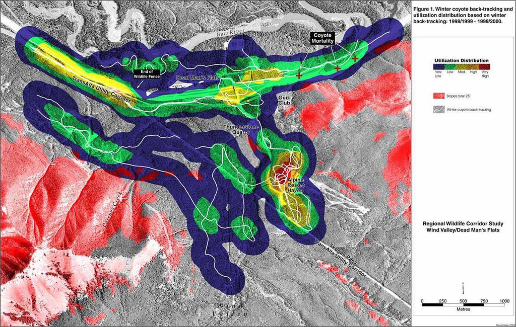
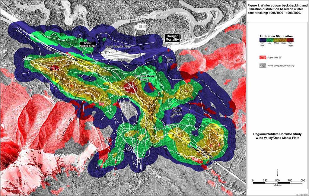
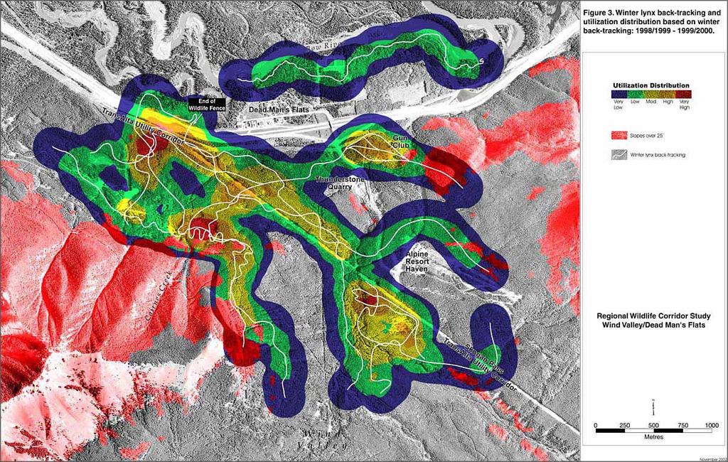
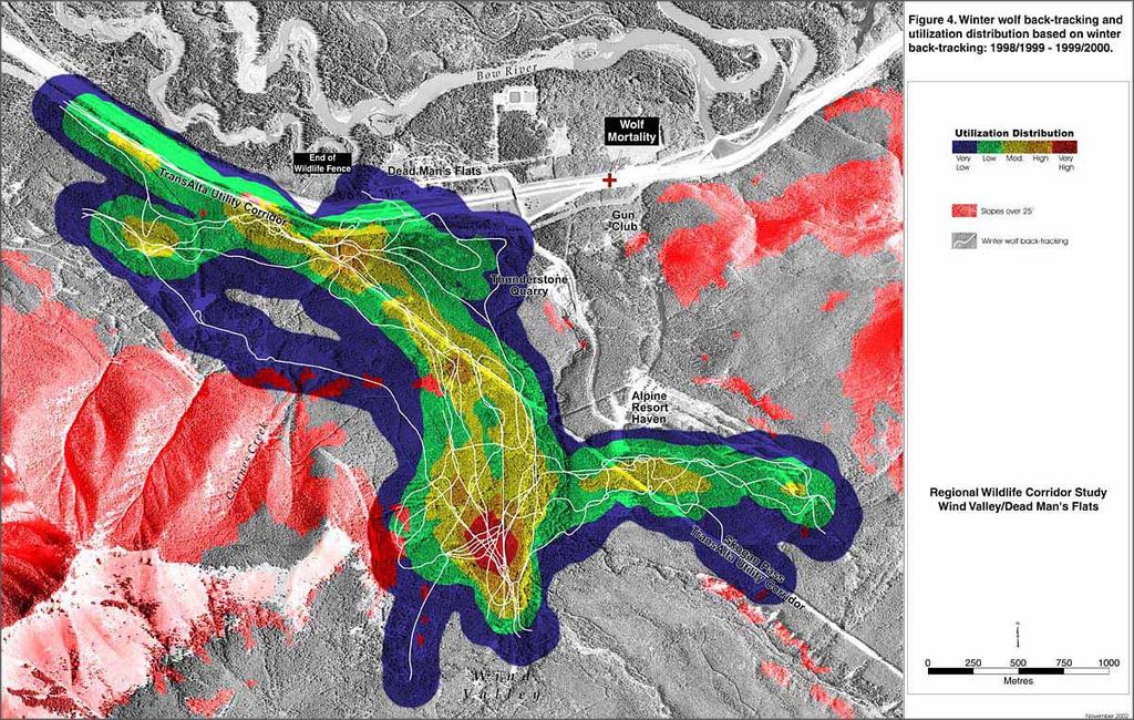
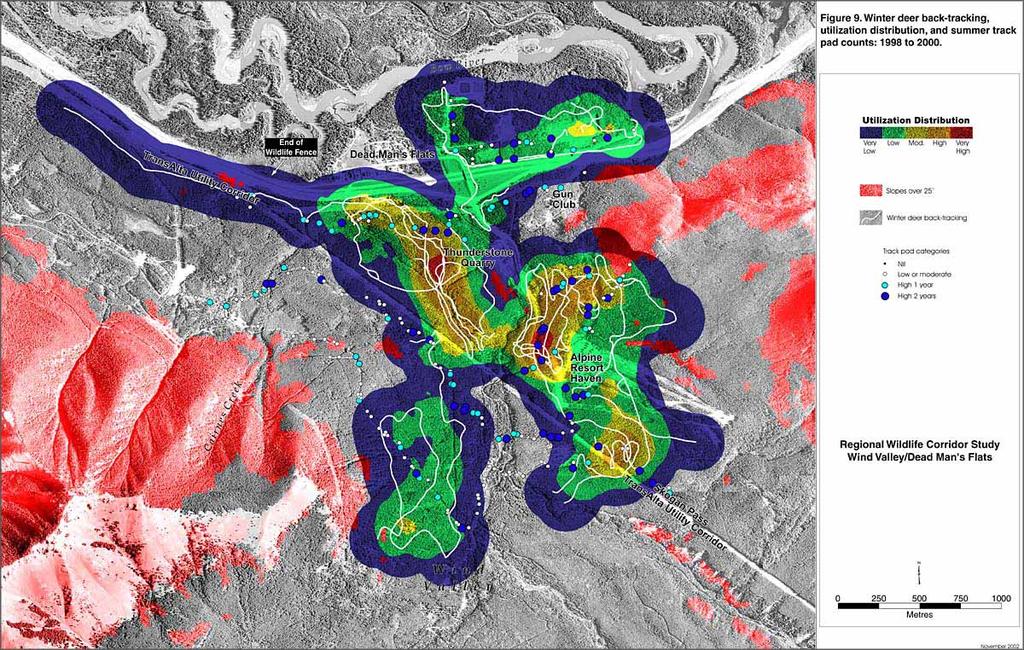
6 6.0 RESULTS 6.1 Winter Backtracking Analyses Utilization distribution maps for individual carnivore species (cougar, wolf, lynx, and coyote) were developed from winter backtracking (Figures 1, 2, 3, 4). While backtracking of carnivores was the highest priority but because of the lower abundance of carnivores, tracking sessions were less than for ungulates. Distribution of track densities identified different movement patterns for each species, however, because of the small sample sizes for some species, the results may not be representative. Coyotes tracking were relatively low in number and demonstrated an affinity for movement up and down the Trans Canada Highway and for the area below Banff Mountain Gate Resort (Figure 1). Coyotes readily adapt to human developments and, therefore, were not given the same weighting in corridors designed for more wary species (i.e. wolves, cougars) where conflicts with humans were undesirable. Lynx and cougars displayed similar movement patterns (Figures 2, 3) especially in relation to movements between Wind Valley and Three Sisters Resorts property. Winter movement primarily followed the Skogan Pass Trans-Alta powerline RoW and then west onto TSR property following either the south side of the property along the base of the steep slopes of Cairnes Creek or paralleling the TCH highway. Backtracking sessions recorded 2 and 3 crossings of the TCH by cougars and lynx respectively and with the 2 lynx crossings actually being the same individual that crossed the highway twice during one tracking session. Both cougars and lynx moved through the area below the built-up footprint of Banff Mountain Gate Resort. The Skogan Pass Trans-Alta powerline RoW where it meets the TCH south to Wind Valley was also used heavily by wolves (Figure 4). Only one crossing of the TCH was documented through winter backtracking and that was immediately west of the Dead Mans Flats. The goal of the study was to identify a multi-species corridor and not corridors for individual species. We therefore addressed this and the concern over small sample size by combining tracking sessions from all carnivores to develop a carnivore utilization distribution (Figure 5). Primary movement areas were located along the Trans-Alta powerline RoW, an area near the TCH west onto TSR property, an area adjacent to the steep slopes of Cairnes Creek, and another area below Alpine Resorts Haven. Deer exhibited considerably less movement through the study area than elk (Figure 6). This movement was confined to areas below Banff Mountain Gate Resort and immediately west of the Thunderstone quarry. A relatively large number of elk backtracking sessions were available for analyses (Figure 7). Primary movement areas for elk coincided with the Skogan Pass Trans-Alta powerline RoW, the Trans-Alta powerline RoW parallel to the TCH, and the area at the base of the steep slopes near Cairnes Creek. There was an area of concentrated movement around the Kananaskis Gun Club and across the TCH into the habitat patch Wind Valley Wildlife Corridor Study
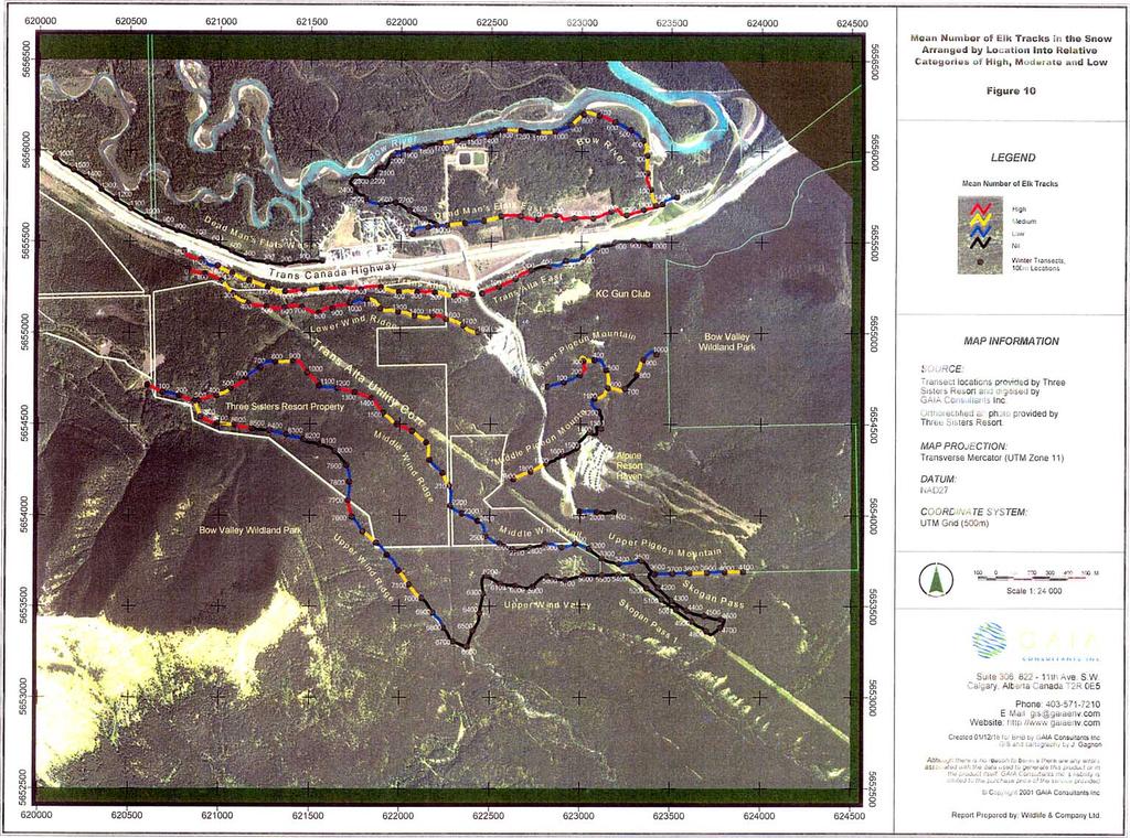
7
8
9
10
11
12
13
14 east of Dead Mans Flats. This habitat patch was identified through pellet group analyses as one of the highest habitats used by elk. Although not identified as moderate or high-use through the utilization distribution analyses, there does appear to be a pattern of movement between the upper portion of the former Pigeon Mountain ski hill and the Kananaskis Gun club. This movement is believed to be a result of elk moving from the winter range slopes on upper Pigeon Mountain to the high quality habitat on the north side of the TCH. Figure 8 shows the summer Track Pad information for elk compared with the utilization distribution from winter backtracking. Although collected during different seasons and using a different methodology, this comparison would indicate differences in seasonal use of the area. The location of high-use Track Pads coincided well with some of the high-use movement areas according to the utilization distribution. This indicated that elk used some of the same areas independent of season. This was particularly evident along the Skogan Pass Trans-Alta powerline RoW and in the area of Cairnes Creek. Areas of dissimilarity were found along the Trans-Alta powerline RoW parallel to the TCH and around the Kananaskis Gun Club. These areas were used heavily by elk in the winter but received relatively little use during the summer. This could be a result of seasonal range differences or it might reflect an increase in human activity at the gun club and along the south side of the TCH during the summer months with a resulting displacement effect. Summer deer use based on Track Pad information showed a wider distribution of deer use during the summer compared to the winter utilization distribution which was confined to a few areas (Figure 9). While too few to be statistically analyzed, tracks of several large carnivores (black bear, grizzly, cougar, and wolves) were detected in some of the Track Pads. Similarities were investigated between winter track counts and the winter backtracking analyses. The comparison between winter track counts for elk (Figure 10) and winter backtracking generally coincided with the utilization distribution of elk. The winter track count data, however, would not have been a good indicator of movement patterns if examined in isolation of the backtracking information. 6.2 Wildlife Mortality Wildlife highway mortality on the TCH was used as an indicator of important crossing areas along the highway for different species. A basic assumption is that any animal crossing any portion of the highway at the entrance to Wind Valley has an equal likelihood of being struck, killed, and found (as opposed to walking off into the adjacent bush and dying). The highway is relatively straight for most of its length except for a slight curve at the western edge. From this curve westerly, there is a wildlife fence along both side of the highway that was installed in October The majority of the highway, however, is unfenced and driver visibility is fairly similar. There may be differences in animal behavior which could predispose one species over another to being struck and killed. For example, coyotes and cougars have been observed running across the highway while larger species such as elk or moose are usually observed walking or Wind Valley Wildlife Corridor Study
15
16
17
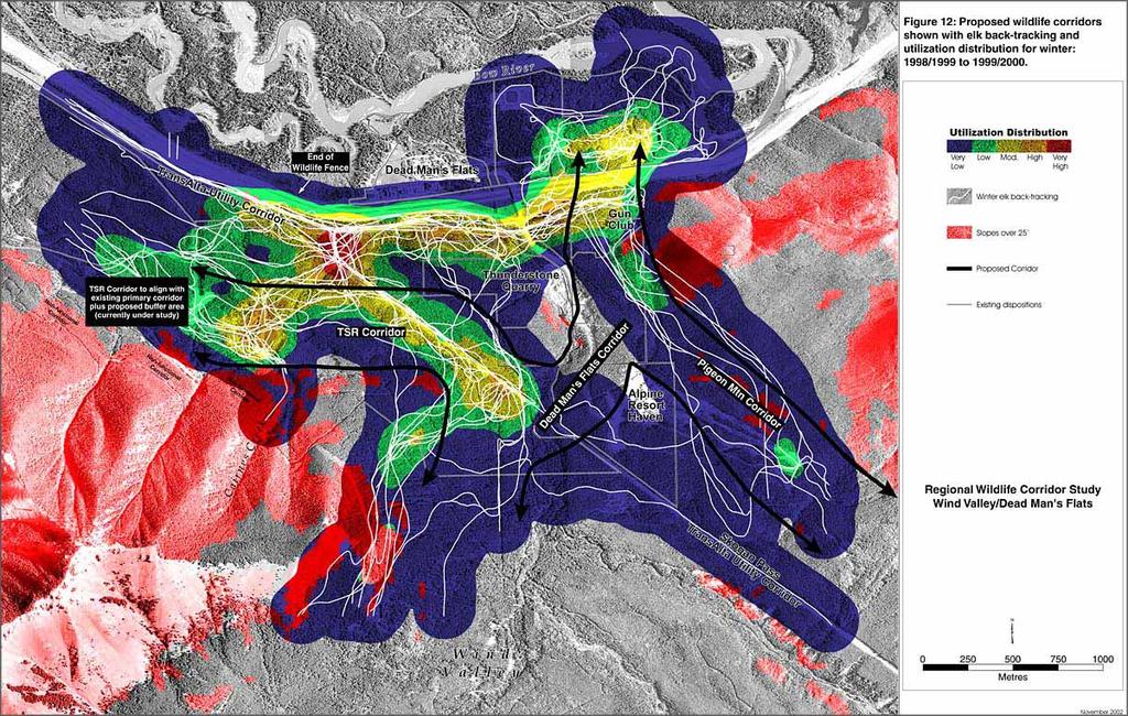
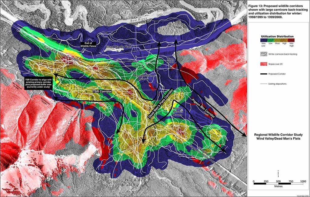
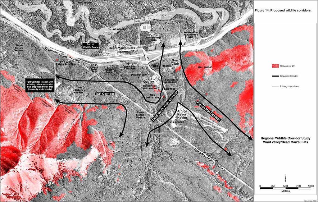
18 moving more slowly across the highway thereby increasing their likelihood of being killed by a vehicle collision. Between January 1998 and September 2001 along the 5.5 km section of the Trans- Canada Highway at the entrance to Wind Valley, twenty-five animals were recorded killed (Figure 11). Both carnivores and ungulates were killed although the number of ungulates was relatively higher. Seventy-six percent of these mortalities occurred within 2km to the east of the Dead Mans Flats overpass indicating a preference for wildlife crossings on the eastside rather than westside of Dead Mans Flats. Mortalities occurred throughout the year. 7.0 WIND VALLEY CORRIDOR ALIGNMENT AND RATIONALE Figure 12 and 13 illustrates the recommended corridor alignments against the backdrop of the utilization distributions for elk and carnivores respectively. These alignments provide linkage with the existing TSR primary corridor and linkage across the TCH into the Bow Flats Natural Area. 7.1 TSR Corridor This corridor connects Wind Valley to the existing TSR primary wildlife corridor. The data suggested that there were two options for corridor alignment that would include most of the moderate, high, and very high utilization areas and still connect with the TSR primary corridor. It was deemed more appropriate to use the movement area closer to the base of the steep slopes at Cairnes Creek (Figure 12, 13). This option would avoid the possible future scenario with development on both sides of a corridor. The data indicates this alignment would be suitable for both ungulates (Figure 12) and carnivores (Figure 13). This corridor is approximately 450 m wide and is consistent with the NRCB Decision report and the BCEAG guidelines. BCEAG guidelines require an additional 100 m to be added onto the baseline corridor width (350 m) to compensate for steeply rising slopes above areas of potential development. This alignment also avoids slopes over 25 degrees that the data indicates were not used extensively by any wildlife species of interest. Because of a small ridge that consists of a steep north-facing slope and extends east from Cairnes Creek, the corridor must swing out to the powerline and around this topographical feature. Movement around this feature is clearly evident for both elk and carnivores from the backtracking sessions (Figure 12, 13). Vegetation cover in the corridor is undisturbed except for small areas along the Skogan Pass Trans-Alta powerline RoW. There are no topographical features in the corridor that would prevent or impede wildlife movement. 7.2 Dead Mans Flats Corridor Habitat connectivity is also required between Wind Valley and the Bow Flats Natural Area. This would require a wildlife corridor across the TCH and preferably linking with Wind Valley Wildlife Corridor Study
19
20
21
22 the TSR primary corridor. Any such corridor must take into consideration future highway mitigation such as fencing and crossing structure requirements as well as human facilities on the north side of the TCH around the hamlet of Dead Mans Flats. A corridor across the TCH requires a decision to align the corridor to the west or east of the Dead Mans Flats hamlet. The utilization distribution information for elk indicated that elk demonstrated a high amount of movement parallel to the highway on the south side of the TCH with high use focal areas at either end (Figure 7) suggesting a corridor would be appropriate at either side of Dead Mans Flats. Such an alignment along the highway would likely lead to a scenario of development on both sides of the corridor. Crossings of the highway were not commonly recorded during winter backtracking sessions. Elk were the most common species that were recorded crossing the highway with most of these crossings being recorded east of the Dead Mans Flats overpass as elk moved over into the very high quality habitat just to the east hamlet of Dead Mans Flats (Figure 7). In addition to elk, coyotes also spent a high amount of time moving back and forth parallel to the highway, especially on the south side. This suggests that the TCH was as a significant barrier to movement for at least elk and coyotes but likely for other species as well. Few carnivore backtracking sessions were recorded crossing the highway (Figure 5). Most highway mortality recorded during the Wind Valley study occurred east of the Dead Mans Flats overpass (Figure 11). Mortality data from previous years also indicates that most mortality was occurring east of the overpass. While significantly less than that of deer and elk, large carnivores (bears, wolves, and cougars) were also victims of highway vehicle collisions. Most of these were also east of the overpass and suggests that this was a more common crossing area and would be the most appropriate location for the crossing. Crossing structures currently employed in Banff National Park and the Stewart Creek structure are most effective if built into existing topographical features adjacent to the highway. West of Dead Mans Flats, the ground is relatively flat on both sides of the highway. An overpass structure built here would require animals to climb relatively steep inclines on both sides of the structure in order to get across the highway. An underpass similar to the Stewart Creek structure would require significant excavations on both sides of the highway. On the north side of the highway, a riparian area associated with Bow River could create water problems for any kind of an underpass. In addition, the Three Sisters campground is located just to the west of Dead Mans Flats and would be impacted by any corridor that directs carnivores across the highway into an area adjacent to the campground. Human/wildlife conflicts are an important consideration in planning the location of any crossing structure. The area of land on the north side of the TCH west of Dead Mans Flats is relatively small and constrained by a channel of the Bow River, which could become a barrier to winter movement. Land east of Dead Mans Flats is a much larger area and consists of high quality habitat for ungulates. Currently the movement of wildlife into this area would create less potential Wind Valley Wildlife Corridor Study
23 for human/wildlife conflicts. There is also a stretch of highway in this area that is considerably above grade and would be a good location for an underpass type structure. Any overpass structure east of the Dead Mans Flats overpass would create a similar problem as that imposed by such a structure to the west of Dead Mans Flats. Based on an assessment of the wildlife tracking information, highway mortality information, and other structural/sociological impacts, it is recommended that the corridor to provide connectivity to the Bow Flats Natural Area be aligned to the east of the Dead Mans Flats overpass. To provide this connection animals need the ability to move between the TSR corridor and an area to the east of the overpass. The elk utilization model (Figure 7) identifies a high use movement corridor paralleling the TCH on the south side that would connect these two areas. This movement, however, may be an artifact of the barrier effect of the highway. Deer tend to prefer the area below Banff Mountain Gate Resort as a cross-valley movement corridor. Carnivores also appear to prefer moving through the area below the Alpine Resort development. Because carnivore movement is the highest priority, a cross-valley connector through this area is the recommended alignment (Figure 12, 13). 7.3 Pigeon Mountain Corridor While not identified as a high-use movement area through the utilization distribution modeling, several elk backtracking sessions were recorded between the upper slopes of the former Pigeon Mountain ski hill and the Kananaskis Gun Club. Many of these tracking sessions continued on across the TCH into the high quality habitat east of the Dead Mans Flats overpass (Figure 7). These tracking sessions either ended or began at the top of the ski hill but were not extended beyond. It is assumed that these elk were moving between the open high elevation winter range on Pigeon Mountain (outside of the study area) and the Dead Mans Flats area. It is recommended that this movement area be recognized as a third important corridor to be recognized and maintained in the Wind Valley area. 8.0 SUMMARY The corridors are aligned to include the majority of the existing movement patterns of the species of concern, especially carnivores. The corridor alignments avoid steep slopes and other topographical features that could create physical barriers. These alignments attempt to avoid, as much as possible, foreseeable future development areas and the Trans- Canada highway. Their alignments attempt to avoid creation of situations where human/wildlife conflicts could arise by providing movement corridors away from existing and future developments and avoiding the pinching of corridors between possible future developments. Some existing developments/dispositions, however, will lie adjacent to or within corridors. For example, Banff Mountain Gate Resort is a resort (time share) type development that will be located adjacent to both the Pigeon Mountain and Dead Man s Wind Valley Wildlife Corridor Study
24 Flats corridors. In addition, the access road to Banff Mountain Gate Resort crosses roughly perpendicularly through the Dead Mans Flats corridor. Similarly, the Kananaskis Gun Club lease may become problematic in the future and must be dealt with as it lies strategically within the Dead Mans Flats corridor immediately south of the Trans Canada Highway. As development of the TSR lands proceeds in the Wind Valley area, the future of the Gun Club in its current location may have to be reevaluated. As a result of these corridor alignments, some of Three Sisters Resort s land becomes split off into two isolated parcels that are surrounded by wildlife corridor and the Bow Valley Wildland Provincial Park. These two parcels are approximately 18.2 and 5.2 hectares in size. The larger parcel lies immediately south and above the TSR Corridor while the smaller parcel is located to the southwest of Banff Mountain Gate Resort across the Trans Alta powerline. While not within the wildlife corridors, development of these parcels could have significant impacts on the functionality of the corridors as well as sensitive wildlife areas in Wind Valley. Any possible future development of these areas will require careful evaluation. The purpose of this study was to identify appropriate science based corridor locations in order to assist in future land use decisions. The locations of these corridors may impact future development on several land holdings in the area (Figure 14). As per the Terms of Reference for the Wind Valley Study, the three developers involved in the study will be required to provide an impact assessment of their respective development proposals on the functionality of the corridors. In addition, as per the Town of Canmore s Municipal Development Plan (MDP), an Area Structure Plan will be required for this area identifying the appropriate distribution of land uses. Also, as per the Town s MDP, an Environmental Impact Statement shall be included in any application for development proposals within or adjacent to Environmentally Sensitive Areas. Wildlife corridors are considered to be Environmentally Sensitive Areas in the MDP. Wind Valley Wildlife Corridor Study
25
Planning Wildlife Crossings in Canada's Mountain Parks SESSION: Highway Mitigation: new insights for practitioners
 Planning Wildlife Crossings in Canada's Mountain Parks ID95 SESSION: Highway Mitigation: new insights for practitioners Trevor Kinley, Project Manager Lake Louise Yoho Kootenay Field Unit, Parks Canada
Labrador - Island Transmission Link Target Rare Plant Survey Locations
 27-28- Figure: 36 of 55 29-28- Figure: 37 of 55 29- Figure: 38 of 55 #* Figure: 39 of 55 30- - east side Figure: 40 of 55 31- Figure: 41 of 55 31- Figure: 42 of 55 32- - secondary Figure: 43 of 55 32-
At the time, the portion of the line through Eagle County remains wholly under the ownership of Union Pacific Railroad (UP).
.") Chapter 5 The Railroad Corridor as a Trail Corridor The intent of this chapter is to identify how the rail corridor, if available for lease or purchase in all or part, could be incorporated into the core
Chapter 5 The Railroad Corridor as a Trail Corridor The intent of this chapter is to identify how the rail corridor, if available for lease or purchase in all or part, could be incorporated into the core
Role of the Protected Area
 Role of the Protected Area Provincial and Regional Context Height of the Rockies and Elk Lakes provincial parks lie in southeastern British Columbia in the Rocky Mountains, about 85 km southwest of Calgary,
Three Sisters Campground Redevelopment
 Three Sisters Campground Redevelopment In 2013 heavy rains in southern Alberta caused flooding along the Bow River that resulted in damage to facilities in the Kananaskis Region including the Three Sisters
Proposal to Redevelop Lower Kananaskis River-Barrier Lake. Bow Valley Provincial Park. Frequently Asked Questions
 Proposal to Redevelop Lower Kananaskis River-Barrier Lake Bow Valley Provincial Park Frequently Asked Questions What is being proposed? What are the details of the proposal? Where is the project area located?
Flying Cloud Airport (FCM) Zoning Process: Informing a Mn/DOT Path Forward
 Zoning Process: Informing a Mn/DOT Path Forward") : Informing a Mn/DOT Path Forward A Review of the Flying Cloud Airport (FCM) Joint Airport Zoning Board (JAZB) Process and the Draft Airport Zoning Ordinance B A RPZ RPZ A B C Zone Chad E. Leqve Director
: Informing a Mn/DOT Path Forward A Review of the Flying Cloud Airport (FCM) Joint Airport Zoning Board (JAZB) Process and the Draft Airport Zoning Ordinance B A RPZ RPZ A B C Zone Chad E. Leqve Director
Jumbo Glacier Resort Master Plan. Appendix 3-K
 Jumbo Glacier Resort Master Plan Appendix 3-K Letter re: Review of M. Austin s Analysis Report: Potential Impacts of the Proposed JGR on the Central Purcell Grizzly Bear Population Prepared by ENKON Environmental
Response to Public Comments
 Appendix D Response to Public Comments Comment Letter # Response 1, 2, 3, 4, 5, 7, 8, 9, 10, 11, 12, 13, 14, 15, 16, 17, 18, 19, 20, 22, 23, 24, 25, 26, 27, 29, 30, 31, 32, 33, 34, 35, 36, 37, 38, 39,
Proposal to Redevelop Lower Kananaskis Lake Campgrounds in Peter Lougheed Provincial Park. What We Heard
 Proposal to Redevelop Lower Kananaskis Lake Campgrounds in Peter Lougheed Provincial Park What We Heard In December 2016, Alberta Parks proposed to make several changes to campgrounds in the Lower Kananaskis
APPENDIX. Alberta Land Stewardship Act AMENDMENTS TO THE SOUTH SASKATCHEWAN REGIONAL PLAN
 APPENDIX Alberta Land Stewardship Act AMENDMENTS TO THE SOUTH SASKATCHEWAN REGIONAL PLAN 1 All references to Alberta Environment and Sustainable Resource Development, Environment and Sustainable Resource
Rule Governing the Designation and Establishment of All-Terrain Vehicle Use Trails on State Land
 Rule Governing the Designation and Establishment of All-Terrain Vehicle Use Trails on State Land 1.0 Authority 1.1 This rule is promulgated pursuant to 23 V.S.A. 3506. Section 3506 (b)(4) states that an
Preferred Recreation Recommendations Stemilt-Squilchuck Recreation Plan March 2018
 Preferred Recreation Recommendations Stemilt-Squilchuck Recreation Plan March 2018 Below are the recommended recreation ideas and strategies that package together the various recreation concepts compiled
K SIGNAGE & TRAFFIC CONTROL. Table of Contents
 Table of Contents K1. ACCOMMODATION OF TRAFFIC... 1 K2. MINIMUM CONSTRUCTION SIGNING... 1 K3. SUBDIVISION SIGNS... 2 K4. TRAFFIC CONTROL DEVICES... 2 K4.1 Traffic Signs Regulations... 2 K4.2 Materials...
A. CONCLUSIONS OF THE FGEIS
 Chapter 11: Traffic and Parking A. CONCLUSIONS OF THE FGEIS The FGEIS found that the Approved Plan will generate a substantial volume of vehicular and pedestrian activity, including an estimated 1,300
BACKCOUNTRY TRAIL FLOOD REHABILITATION PROGRAM
 BACKCOUNTRY TRAIL FLOOD REHABILITATION PROGRAM Backcountry Trail Flood Rehabilitation A June 2013 Flood Recovery Program Summary In June 2013, parts of Southern Alberta were devastated from significant
Yard Creek Provincial Park. Management Plan
 Yard Creek Provincial Park Management Plan Draft January 2010 Yard Creek Provincial Park Management Plan Approved by: telàlsemkin/siyam/chief Scott Benton Bill Williams Squamish Executive Director ation
ROAD AND TRAIL PROJECT APPROVAL
 ROAD AND TRAIL PROJECT APPROVAL www.marincountyparks.org Marin County Parks, 3501 Civic Center Dr, Suite 260, San Rafael, CA 94903 DATE: July 12, 2017 PRESERVE: Gary Giacomini Open Space Preserve PROJECT:
GOLDEN BACKCOUNTRY RECREATION ADVISORY COMMITTEE (GBRAC)
") GOLDEN BACKCOUNTRY RECREATION ADVISORY COMMITTEE (GBRAC) MINUTES from November 1, 2006 Meeting Attending: Sector / Stakeholder GBRAC Commercial Aerial Motorized Sector GBRAC Habitat Protection; Sport Fishing
GOLDEN BACKCOUNTRY RECREATION ADVISORY COMMITTEE (GBRAC) MINUTES from November 1, 2006 Meeting Attending: Sector / Stakeholder GBRAC Commercial Aerial Motorized Sector GBRAC Habitat Protection; Sport Fishing
Private Land Conservation Opportunities in Alberta s Bow Valley
 Private Land Conservation Opportunities in Alberta s Bow Valley Technical Report #9 July 2010 By: Karsten Heuer and Tracy Lee Yellowstone to Yukon Conservation Initiative Technical Report #9 July 2010
Appendix B Ultimate Airport Capacity and Delay Simulation Modeling Analysis
 Appendix B ULTIMATE AIRPORT CAPACITY & DELAY SIMULATION MODELING ANALYSIS B TABLE OF CONTENTS EXHIBITS TABLES B.1 Introduction... 1 B.2 Simulation Modeling Assumption and Methodology... 4 B.2.1 Runway
Backgrounder Plains Bison Reintroduction to Banff National Park
 Backgrounder Plains Bison Reintroduction to Banff National Park Introduction The five-year reintroduction project is a small- scale initiative that would inform future decisions regarding the feasibility
Proposed Action. Payette National Forest Over-Snow Grooming in Valley, Adams and Idaho Counties. United States Department of Agriculture
 United States Department of Agriculture Forest Service January 2012 Proposed Action Payette National Forest Over-Snow Grooming in Valley, Adams and Idaho Counties Payette National Forest Valley, Adams
HIGHWAY CONFLICTS AND RESOLUTIONS IN BANFF NATIONAL PARK, ALBERTA, CANADA
 HIGHWAY CONFLICTS AND RESOLUTIONS IN BANFF NATIONAL PARK, ALBERTA, CANADA By: Dr. Bruce F. Leeson Senior Environmental Assessment Scientist Parks Canada - Alberta Region Calgary, Alberta Tel: (403) 2924438
A GIS Analysis of Probable High Recreation Use Areas in Three Sisters Wilderness Deschutes and Willamette National Forests
 Lindsey Kiesz Geo 565 Term Project 3/15/2010 A GIS Analysis of Probable High Recreation Use Areas in Three Sisters Wilderness Deschutes and Willamette National Forests Introduction The Three Sisters Wilderness
BOW CORRIDOR ECOSYSTEM ADVISORY GROUP
 BOW CORRIDOR ECOSYSTEM ADVISORY GROUP Bow Corridor Ecosystem Advisory Group (BCEAG) GUIDELINES FOR HUMAN USE WITHIN WILDLIFE CORRIDORS AND HABITAT PATCHES IN THE BOW VALLEY (BANFF NATIONAL PARK TO SEEBE)
BIG ANIMALS and SMALL PARKS: Implications of Wildlife Distribution and Movements for Expansion of Nahanni National Park Reserve. John L.
 BIG ANIMALS and SMALL PARKS: Implications of Wildlife Distribution and Movements for Expansion of Nahanni National Park Reserve John L. Weaver Conservation Report No.1 July 2006 4 SUMMARY The boundaries
MEMORANDUM. Open Section Background. I-66 Open Section Study Area. VDOT Northern Virginia District. I-66 Project Team. Date: November 5, 2015
 MEMORANDUM To: VDOT Northern Virginia District From: I-66 Project Team Date: November 5, 2015 Subject: Open Section Background The purpose of this technical memorandum is to provide narrative and technical
BLANKET CREEK PROVINCIAL PARK
 BLANKET CREEK PROVINCIAL PARK PURPOSE STATEMENT AND ZONING PLAN February 2003 BLANKET CREEK PROVINCIAL PARK Purpose Statement and Zoning Plan Primary Role The primary role of Blanket Creek Park is to maintain
MANAGEMENT DIRECTION STATEMENT June, 1999
 Thompson River District MANAGEMENT DIRECTION STATEMENT June, 1999 for Roche Lake Provincial Park Ministry of Environment Lands and Parks BC Parks Division Table of Contents I. Introduction A. Setting
Crown of the Continent Ecosystem The Glacier-Great Bear Connectivity Conservation Area Briefing
 Crown of the Continent Ecosystem The Glacier-Great Bear Connectivity Conservation Area Briefing By: Rob Ament & Tyler Creech October 2016 The Glacier-Great Bear Connectivity Conservation Area The Crown
White Mountain National Forest Saco Ranger District
 United States Department of Agriculture Forest Service White Mountain National Forest Saco Ranger District 33 Kancamagus Highway Conway, NH 03818 Comm: (603) 447-5448 TTY: (603) 447-3121 File Code: 1950
Sawtooth National Forest Fairfield Ranger District
 United States Department of Agriculture Forest Service Sawtooth National Forest Fairfield Ranger District P.O. Box 189 Fairfield, ID. 83327 208-764-3202 Fax: 208-764-3211 File Code: 1950/7700 Date: December
1.0 BACKGROUND NEW VETERANS CHARTER EVALUATION OBJECTIVES STUDY APPROACH EVALUATION LIMITATIONS... 7
 New Veterans Charter Evaluation Plan TABLE CONTENTS Page 1.0 BACKGROUND... 1 2.0 NEW VETERANS CHARTER EVALUATION OBJECTIVES... 2 3.0 STUDY APPROACH... 3 4.0 EVALUATION LIMITATIONS... 7 5.0 FUTURE PROJECTS...
Trail Phasing Plan. Note: Trails in the Clear Creek Canyon area (Segments will be finalized in the future to minimize wildlife impacts
 Note: Trails in the Clear Creek Canyon area (Segments 2 5 and a future JCOS connection) will be finalized in the future to minimize wildlife impacts Trail Phasing Plan P Parking 3 Easy Trail Intermediate
2009 Muskoka Airport Economic Impact Study
 2009 Muskoka Airport Economic Impact Study November 4, 2009 Prepared by The District of Muskoka Planning and Economic Development Department BACKGROUND The Muskoka Airport is situated at the north end
WELCOME to the Iditarod Dog Sledding Historic District (IDSHD) Workshop. January 11, Houston Middle School Houston, Alaska
 Workshop. January 11, Houston Middle School Houston, Alaska") WELCOME to the Iditarod Dog Sledding Historic District (IDSHD) Workshop January 11, 2012 Houston Middle School Houston, Alaska Workshop Purpose: Present/discuss proposed resolutions to comments received
WELCOME to the Iditarod Dog Sledding Historic District (IDSHD) Workshop January 11, 2012 Houston Middle School Houston, Alaska Workshop Purpose: Present/discuss proposed resolutions to comments received
EAST DON TRAIL ENVIRONMENTAL ASSESSMENT. Community Liaison Committee Meeting #3 July 15, :30 to 8:30 pm Flemingdon Park Library
 EAST DON TRAIL ENVIRONMENTAL ASSESSMENT Community Liaison Committee Meeting #3 July 15, 2013 6:30 to 8:30 pm Flemingdon Park Library Agenda 1. Welcome 2. Housekeeping and Updates a) Housekeeping b) CLC
Keeping Wilderness Wild: Increasing Effectiveness With Limited Resources
 Keeping Wilderness Wild: Increasing Effectiveness With Limited Resources Linda Merigliano Bryan Smith Abstract Wilderness managers are forced to make increasingly difficult decisions about where to focus
Bow Corridor Regional Transportation Strategy. Moving People and Animals with ease
 Roads Rivers and Lakes CPR Tracks Wildlife corridors 93N Pipestone River 1 Lake Louise Moraine Lake 1 TransCanada Highway 40 Highways Castle Junction Johnston Canyon 93S 1 Alpine Upper Subalpine Lower
KANANASKIS COUNTRY PROVINCIAL RECREATION AREAS MANAGEMENT PLAN DRAFT TERMS OF REFERENCE - November 20, 2007
 KANANASKIS COUNTRY PROVINCIAL RECREATION AREAS MANAGEMENT PLAN DRAFT TERMS OF REFERENCE - November 20, 2007 BACKGROUND There are 42 Provincial Recreation Areas (PRAs) within Kananaskis Country located
MONTEREY REGIONAL AIRPORT MASTER PLAN TOPICAL QUESTIONS FROM THE PLANNING ADVISORY COMMITTEE AND TOPICAL RESPONSES
 MONTEREY REGIONAL AIRPORT MASTER PLAN TOPICAL QUESTIONS FROM THE PLANNING ADVISORY COMMITTEE AND TOPICAL RESPONSES Recurring topics emerged in some of the comments and questions raised by members of the
Proposal to Redevelop Lower Kananaskis River-Barrier Lake. Bow Valley Provincial Park
 Frequently Asked Questions Proposal to Redevelop Lower Kananaskis River-Barrier Lake Bow Valley Provincial Park Frequently Asked Questions What has been decided? What are the details of the plan? What
Northeast Stoney Trail In Calgary, Alberta
 aci Acoustical Consultants Inc. 5031 210 Street Edmonton, Alberta, Canada T6M 0A8 Phone: (780) 414-6373, Fax: (780) 414-6376 www.aciacoustical.com Environmental Noise Computer Modelling For Northeast Stoney
Water Quality Trends for Patchogue Bay
 Water Quality Trends for Patchogue Bay 2018 This report summarizes water quality data for fecal coliform and total coliform in Patchogue Bay for the years 2003-2017. Prepared by: Brian M. McCaffrey Stormwater
The following criteria were used to identify Benchmark Areas:
 7.0 BENCHMARK AREAS The Churn Creek Protected Area offers a significant opportunity to learn more about how grassland ecosystems function. One of the key tools that will be used to monitor larger grassland
FEASIBILITY CRITERIA
 This chapter describes the methodology and criteria used to evaluate the feasibility of developing trails throughout the study areas. Land availability, habitat sensitivity, roadway crossings and on-street
Interstate 90 and Mercer Island Mobility Study APRIL Commissioned by. Prepared by
 Interstate 90 and Mercer Island Mobility Study APRIL 2017 Commissioned by Prepared by Interstate 90 and Mercer Island Mobility Study Commissioned by: Sound Transit Prepared by: April 2017 Contents Section
Port Bruce. Interim Management Statement
 Port Bruce Interim Management Statement Port Bruce Interim Management Statement August 3, 1999 This Port Bruce Provincial Park Interim Management Statement provides direction for the custodial management
ANAGEMENT P LAN. February, for Elk Lakes and Height of the Rockies Provincial Parks. Ministry of Environment, Lands and Parks BC Parks Division
 M ANAGEMENT P LAN February, 1999 for Elk Lakes and Height of the Rockies Provincial Parks Ministry of Environment, Lands and Parks BC Parks Division Elk Lakes & Height of the Rockies Provincial Parks M
A number of goals were identified during the initial work on this Big Lake Transportation Plan.
 C. Transportation General Background Information Big Lake s transportation system includes all the roads, paths and facilities that allow the movement of private vehicles, trains and planes, as well as
PROPOSED ACTION South 3000 East Salt Lake City, UT United States Department of Agriculture
 United States Department of Agriculture Forest Service Uinta-Wasatch-Cache National Forest Salt Lake Ranger District 6944 South 3000 East Salt Lake City, UT 84121 801-733-2660 File Code: 1950/2300 Date:
CHAPTER 6 NOISE EXPOSURE
 CHAPTER 6 NOISE EXPOSURE FAA requires that the NEM submitted for review represent the aircraft noise exposure for the year of submittal (in this case 2008) and for a future year (2013 for OSUA). However,
Digital Terrain Analysis of Archer Mountain
 Digital Terrain Analysis of Archer Mountain Identifying a potential new recreational trail Photo: Justin Bush GEOG 593 - Duh Marcus Tobey Justin Bush Project Overview Background Project Area Overview Questions
Section 61 Recreational Vehicle Park / Campground (Bylaw No. 2012/10)
") Part 7 General Regulations Section 61 Recreational Vehicle Park / Campground (Bylaw No. 2012/10) 61.1 A comprehensive site plan shall be provided to the satisfaction of the Development Authority that shows
Part 7 General Regulations Section 61 Recreational Vehicle Park / Campground (Bylaw No. 2012/10) 61.1 A comprehensive site plan shall be provided to the satisfaction of the Development Authority that shows
MANAGEMENT DIRECTION STATEMENT June, 1999
 Thompson River District MANAGEMENT DIRECTION STATEMENT June, 1999 for Clearwater River Corridor (Addition to Wells Gray Park) Ministry of Environment Lands and Parks BC Parks Division ii Table of Contents
Committee. Presentation Outline
 CW-33-15 11/9/2015 Community and Corporate Services Committee November 10, 2015 1 Presentation Outline Background Vision and Objectives Study Process and Timeline Public and Stakeholder Engagement Organization
As outlined in the Tatshenshini-Alsek Park Management Agreement, park management will:
 Management Strategy General Strategy The priority management focus for the park is to ensure that its internationally significant natural, cultural heritage and recreational values are protected and that
Restore and implement protected status that is equivalent, or better than what was lost during the mid-1990 s
 THE ROSSLAND RANGE, OLD GLORY AREA. Executive summary. The Friends of the Rossland Range Society, on behalf of the local outdoor community, seeks to accomplish the following with respect to the Old Glory
Disclosure Document for Castle Mountain Resort Future Development
 Disclosure Document for Castle Mountain Resort Future Development September 2018 1._ Introduction Castle Mountain Resort Inc. (CMR) has completed a Master Development Plan that proposes to expand the existing
ROUTE ANALYSIS PROCESS
 ROUTE ANALYSIS PROCESS Progress to Date: 1. Recorded and labeled all routes received from PAT Meetings. 2. Determined opportunity, avoidance and exclusion areas crossed by PAT proposed routes. 3. Routes
MAPPING UNSHELTERED HOMELESSNESS IN INDIANAPOLIS ISSUE C17-20 NOVEMBER 2017
 MAPPING UNSHELTERED HOMELESSNESS IN INDIANAPOLIS ISSUE C17-20 NOVEMBER 2017 AUTHOR Chris Holcomb, Graduate Student, School of Public and Environmental Affairs, IUPUI 334 N. Senate Avenue, Suite 300 Indianapolis,
THE ALBERTA GAZETTE, SEPTEMBER
 VILLAGE OF CEREAL Order No. 16915 IN THE MATTER OF THE "Municipal Government Act": File No. 241(A)3 AND IN THE MATTER OF an application by the Council of the Village of Cereal, in the Province of Alberta,
Mitigating Wildlife Mortality and Habitat Fragmentation Due to Transportation Infrastructure
 Mitigating Wildlife Mortality and Habitat Fragmentation Due to Transportation Infrastructure by Anthony P. Clevenger, Ph.D Research Scientist Western Transportation Institute College of Engineering Montana
American Airlines Next Top Model
 Page 1 of 12 American Airlines Next Top Model Introduction Airlines employ several distinct strategies for the boarding and deboarding of airplanes in an attempt to minimize the time each plane spends
Dr. Melissa Grigione And Kurt Menke. Jaguar -Arturo. Jaguarundi -Arturo. Ocelot -Arturo. Caso. Caso. Caso
 Identifying Priority Conservation Areas in the U.S.- Mexico Border Region for America s Neotropical Cats, the Jaguar, Jaguarundi and Ocelot: An International Effort Dr. Melissa Grigione And Kurt Menke
Stage 2 - November 2017 Survey and Map Comments (verbatim)
") Stage 2 - November 2017 Survey and Map Comments (verbatim) Identifying information removed to meet Freedom of Information and Protection of Privacy Act (FOIP Act). Comments are recorded exactly as they
Stage 2 - November 2017 Survey and Map Comments (verbatim) Identifying information removed to meet Freedom of Information and Protection of Privacy Act (FOIP Act). Comments are recorded exactly as they
According to FAA Advisory Circular 150/5060-5, Airport Capacity and Delay, the elements that affect airfield capacity include:
 4.1 INTRODUCTION The previous chapters have described the existing facilities and provided planning guidelines as well as a forecast of demand for aviation activity at North Perry Airport. The demand/capacity
Original Report F WIN , F WIN Prepared for Northland Power and Ministry of Tourism and Culture
 STAGE 2 ARCHAEOLOGICAL ASSESSMENT McLEAN S MOUNTAIN WIND FARM Part Lots 12-15, Concession 3 Geographic Township of Howland Part Lot 24, Concession 12 Geographic Township of Bidwell and Goat Island (formerly
United States Department of the Interior National Park Service. Boundary Expansion Listed in National Register January 11, 2017
 NPS Form 10900-a (Rev. 8/2002) OMB No. 10240018 United States Department of the Interior National Park Service Boundary Expansion Listed in National Register January 11, 2017 National Register of Historic
Preliminary Findings of Proposed Alternative
 Preliminary Findings of Proposed Alternative The attached drawing provides a schematic layout of the proposed alternative that will be discussed on July 27, 2010. A full report will follow and should be
Citrus Heights Creek Corridor Trail Project. Trail Advisory Group Meeting #3 July 8, 2013
 Citrus Heights Creek Corridor Trail Project Trail Advisory Group Meeting #3 July 8, 2013 Agenda Introductions Recap: Community Workshop, Survey Findings, and TAG Field Trip Community Concern Discussion:
Madison Metro Transit System
 Madison Metro Transit System 1101 East Washington Avenue Madison, Wisconsin, 53703 Administrative Office: 608 266 4904 Fax: 608 267 8778 TO: FROM: SUBJECT: Plan Commission Timothy Sobota, Transit Planner,
Map 1.1 Wenatchee Watershed Land Ownership
 Map 1.1 Wenatchee Watershed Land Ownership Map 1.1 Wenatchee Watershed Land Ownership The Wenatchee watershed lies in the heart of Washington state in Chelan County. Just larger than the state of Rhode
PROPOSAL FOR RECLASSIFICATION, BOUNDARY AMENDMENT AND DRAFT CONCEPT PLAN FOR SASKATOON MOUNTAIN NATURAL AREA. Frequently Asked Questions
 PROPOSAL FOR RECLASSIFICATION, BOUNDARY AMENDMENT AND DRAFT CONCEPT PLAN FOR SASKATOON MOUNTAIN NATURAL AREA 1. Why is this proposal being put forward? Frequently Asked Questions For many years, Alberta
AURORA WILDLIFE RESEARCH
 AURORA WILDLIFE RESEARCH Kim Poole 2305 Annable Rd. Nelson, BC, V1L 6K4 Canada Tel: (250) 825-4063; Fax: (250) 825-4073 e-mail: klpoole@shaw.ca 27 April 2005 Mike Gall Conservation Specialist and Glenn
MESA COUNTY DEPARTMENT OF PUBLIC WORKS Administration - Building - Engineering Road and Bridge Traffic - Planning - Solid Waste Management
 MESA COUNTY DEPARTMENT OF PUBLIC WORKS Administration - Building - Engineering Road and Bridge Traffic - Planning - Solid Waste Management 200 S. Spruce St. P.O. Box 20,000 Grand Junction, Colorado 81502-5022
TORONTO PEARSON INTERNATIONAL AIRPORT NOISE MANAGEMENT
 TORONTO PEARSON INTERNATIONAL AIRPORT NOISE MANAGEMENT Noise and the GTAA The GTAA is sensitive to the issue of aircraft noise and how it affects our neighbours. Since assuming responsibility for Toronto
International Snow Science Workshop
 A PRACTICAL USE OF HISTORIC DATA TO MITIGATE WORKER EXPOSURE TO AVALANCHE HAZARD Jake Elkins Jackson Hole Mountain Resort, Teton Village, Wyoming Bob Comey* Jackson Hole Mountain Resort, Teton Village,
L ANDS ADJACENT TO BANFF TRAILS STUDY
 L ANDS ADJACENT TO BANFF TRAILS STUDY Copies of this report may be obtained from: Banff National Park Park Planner Parks Canada Banff National Park P.O. Box 900 Banff, AB, T1L 1K2 A copy of this report
ANAGEMENT. LAN November, 1996
 M ANAGEMENT P LAN November, 1996 for Coldwater River Provincial Park Ministry of Environment, Lands and Parks BC Parks Department Coldwater River Provincial Park M ANAGEMENT P LAN Prepared by BC Parks
Ouimet Canyon Provincial Nature Reserve. Management Plan
 Ouimet Canyon Provincial Nature Reserve Management Plan NOTE: This document has been scanned and formatted, and therefore is slightly different from the original version. -March 2002 Additional copies
CHAPTER 5 SEPARATION METHODS AND MINIMA
 CHAPTER 5 SEPARATION METHODS AND MINIMA 5.1 Provision for the separation of controlled traffic 5.1.1 Vertical or horizontal separation shall be provided: a) between IFR flights in Class D and E airspaces
Prior to contacting the Whitecourt Trailblazers Snowmobile Club, applicants must:
 WHITECOURT TRAILBLAZERS Box 607 Whitecourt, AB T7S 1N7 www.whitecourttrailblazers.ca CNT AMENDMENT Restriction Code 710: See Comments Comments All applicants are required to contact: Whitecourt Trailblazers
Road Ecology Center escholarship Repository John Muir Institute of the Environment University of California, Davis
 Road Ecology Center escholarship Repository John Muir Institute of the Environment University of California, Davis Year Paper Tremblaya Modeling and management of potential movement for elk (Cervus elaphus),
RECREATION. Seven issues were identified that pertain to the effects of travel management on outdoor recreation within portions of the project area.
 RECREATION Seven issues were identified that pertain to the effects of travel management on outdoor recreation within portions of the project area. OPPORTUNITIES FOR SOLITUDE / QUIET TRAILS. One attraction
Exemplar for Internal Achievement Standard Geography Level 1. Conduct geographic research, with direction
 Exemplar for internal assessment resource Geography for Achievement Standard 91011 Exemplar for Internal Achievement Standard Geography Level 1 This exemplar supports assessment against: Achievement Standard
2. Goals and Policies. The following are the adopted Parks and Trails Goals for Stillwater Township:
 D. PARKS AND TRAILS 1. Introduction Stillwater Township s population is relatively low, with most residents living on rural residences on large lots. The need for active park space has been minimal in
CONGESTION MONITORING THE NEW ZEALAND EXPERIENCE. By Mike Curran, Manager Strategic Policy, Transit New Zealand
 CONGESTION MONITORING THE NEW ZEALAND EXPERIENCE 26 th Australasian Transport Research Forum Wellington New Zealand 1-3 October 2003 By, Manager Strategic Policy, Transit New Zealand Abstract New Zealand
Water Quality Trends for Conscience Bay
 Water Quality Trends for Conscience Bay 2018 This report summarizes water quality data for fecal coliform and total coliform in Conscience Bay for the years 1998-2018. Prepared by: Brian M. McCaffrey Stormwater
APPENDIX D MSP Airfield Simulation Analysis
 APPENDIX D MSP Airfield Simulation Analysis This page is left intentionally blank. MSP Airfield Simulation Analysis Technical Report Prepared by: HNTB November 2011 2020 Improvements Environmental Assessment/
THRESHOLD GUIDELINES FOR AVALANCHE SAFETY MEASURES
 BRITISH COLUMBIA MINISTRY OF TRANSPORTATION & INFRASTRUCTURE AVALANCHE & WEATHER PROGRAMS THRESHOLD GUIDELINES FOR AVALANCHE SAFETY MEASURES British Columbia Ministry of Transportation & Infrastructure
Robson Valley Avalanche Tract Mapping Project
 Robson Valley Avalanche Tract Mapping Project Prepared for: Chris Ritchie Ministry of Water Land and Air Protection 325 1011 4th Avenue Prince George, BC. V2L3H9 and Dale Seip Ministry of Forests 1011
Visual and Sensory Aspect
 Updated All Wales LANDMAP Statistics 2017 Visual and Sensory Aspect Final Report for Natural Resources Wales February 2018 Tel: 029 2043 7841 Email: sw@whiteconsultants.co.uk Web: www.whiteconsultants.co.uk
Trail Assessment Report
 Trail Assessment Report Trail Options for the Bear Creek Canyon located in Pikes Peak Ranger District, Pike National Forest and on Colorado Springs Utility Lands Due to the presence of a unique species
USE OF 3D GIS IN ANALYSIS OF AIRSPACE OBSTRUCTIONS
 USE OF 3D GIS IN ANALYSIS OF AIRSPACE OBSTRUCTIONS A project by by Samuka D. W. F19/1461/2010 Supervisor; Dr D. N. Siriba 1 Background and Problem Statement The Airports in Kenya are the main link between
Draft Concept Alternatives Analysis for the Inaugural Airport Program September 2005
 Section 10 Preferred Inaugural Airport Concept 10.0 Introduction The Preferred Inaugural Airport Concept for SSA was developed by adding the preferred support/ancillary facilities selected in Section 9
Skiing and Snowshoes on Un-groomed Fernan Saddle Terrain
 Skiing and Snowshoes on Un-groomed Fernan Saddle Terrain Three ski or snowshoe routes are available from the Fernan Saddle Parking Lot which either do not cover routes ordinarily groomed for snow machine
Recreation Opportunity Spectrum for River Management v
 Recreation Opportunity Spectrum for Management v. 120803 Introduction The following Recreation Opportunity Spectrum (ROS) characterizations and matrices mirror the presentation in the ROS Primer and Field
ENVIRONMENTAL HAZARDS OF AVALANCHES: PRELIMINARY RESEARCH IN GLACIER NATIONAL PARK
 ENVIRONMENTAL HAZARDS OF AVALANCHES: PRELIMINARY RESEARCH IN GLACIER NATIONAL PARK Site Focus: Balu Pass, Glacier National Park, B.C. Avalanche path near Balu Pass. (Photo Courtesy of: www.leelau.net/2007/rogerspass/day1/1)