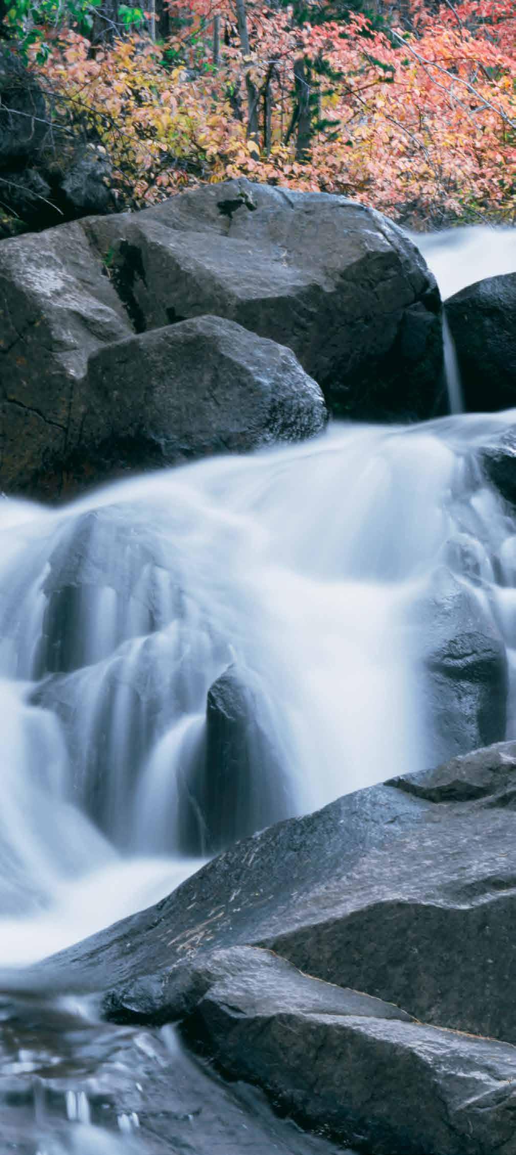
1O Easy SIERRA DAY HIKES
|
|
|
- Mercy Robertson
- 5 years ago
- Views:
Transcription


1 1O Eas SIERRA DAY HIKES

2 10 DAY HIKES North AND west OF YOSEMITE Bear Valle Arnold Murphs 2 7 Pinecrest 1 9 Sonora 6 Yosemite National Park 9 Groveland El Portal 9 1 The area of the Sierra Nevada north and west of Yosemite Park rises graduall from California s Central Valle to elevations over 11,000. It includes the Stanislaus National Forest, the Emigrant and Carson-Iceberg Wilderness areas, and a number of small towns. Opportunities abound for the outdoor enthusiast. Here are 10 of the region s best da hikes.
3 9 HERON PT. TRAIL Angels Camp 9 New Melones Lake 9 Sonora heron point trail new melones recreation area EASY 1 OR 2.5 MILE ROUND TRIP SEASON: ACCESSIBLE YEAR-ROUND VIEWS OF LAKE, BIRDS, WILDFLOWERS TO TRAILHEAD ELEVATION: 1,100 From Sonora, take Hw 9 north towards Angels Camp for 8 miles. Turn left onto Renolds Ferr Rd at the sign for Tuttletown Recreation Area. Go through the entrance station and past Acorn Campground on our right. Turn right onto the short road to the Heron Point da-use area. The trail begins at the gate near the restroom and parking area. Those wanting a loop hike can follow the trail approximatel 1 mile, then take a shortcut on the right back to the trailhead. At 0.3 miles past this cutoff, the trail comes to a T. Going left takes ou to the reservoir. Going right takes ou up to the Acorn Campground, or ou can retrace our route back for a 2 mile hike. Open ear-round, the scenic Heron Point Trail winds along the shoreline of New Melones Reservoir. It is part of a larger sstem of trails located in the New Melones Recreation Area.
4 9 Angels Camp 9 PARROTTS FERRY RD Columbia New Melones Lake 9 9 Sonora 9 2 NATURAL BRIDGES TRAIL NEW MELONES RECREATION AREA MODERATE 2 MILE ROUND TRIP SEASON: ACCESSIBLE YEAR-ROUND VIEW (OR SWIM THROUGH) LIMESTONE CAVE TO TRAILHEAD ELEVATION: 1,500 Look for the sign for the trailhead on the west side of Parrotts Ferr Road, 6 miles north of Columbia or 3.7 miles south from Highwa. Park in the dirt off Parrotts Ferr or down along the spur road. The trail starts at the round metal gate on the west side of the spur road. The trail descends 00 feet in elevation to Coote Creek, which flows through limestone caves to create natural bridges. The water can be cold even in summer, but ou can swim through the caves or enjo one of the swimming holes along the creek. Be careful to avoid poison oak. Remember that unique geological structures such as these can take thousands of ears to form, so make an extra effort to avoid causing an harm when visiting this unique low-elevation site.

5 Arnold Calaveras Big Trees State Park NORTH GROVE BIG TREES TRAIL Murphs TO ANGELS CAMP 3 NORTH GROVE LOOP TRAIL CALAVERAS BIG TREES STATE PARK EASY 1.5 MILE ROUND TRIP SEASON: ACCESSIBLE YEAR-ROUND ANCIENT GIANT SEQUOIAS, GUIDED TOURS TO TRAILHEAD ELEVATION:,700 Head east on Highwa until ou see signs for Calaveras Big Trees State Park - about 3 miles past Arnold. Turn right and pa the $10 fee at the entrance station. Park in the main parking lot to access the North Grove as well as the visitor center. There aren t man places in the Sierra Nevada to see spectacular Giant Sequoia groves. These huge trees can live to be 3,000 ears old! The flat, handicap-accessible North Grove Trail provides eas access to man impressive trees, and guided hikes are offered periodicall.
6 DUCK LAKE TRAIL Lake Alpine Bear Valle lake alpine Dorrington t TO ANGELS CAMP DUCK LAKE STANISLAUS NATIONAL FOREST EASY 2.5 MILE ROUND TRIP SEASON: SUMMER & FALL ALPINE LAKE, EXPOSED GRANITE, WILD AREA TO TRAILHEAD ELEVATION: 7,200 From Arnold, head east on Highwa for about 29 miles to Lake Alpine. Turn right at the east shore of the lake, and head a short distance upslope to the Silver Valle Trailhead, near the entrance to the Silver Valle Campground. The trail starts with a mild uphill section. Be sure to sta on the main fork headed southeast to Duck Lake. The gentle trail swings over a ridge and winds down to the west of Duck Lake, a small, grass lake in the Carson-Iceberg Wilderness. Visitors ma see beautiful wildflowers and wildlife, especiall if ou extend the hike b following the trail around Duck lake. Mosquitos love the marsh meadow conditions in spring, so bring repellent if ou visit earl! Energetic hikers can add an hourlong walk around Lake Alpine at the start or end of the Duck Lake hike.

7 Bear Valle lake alpine ebbetts pass noble lake t TO angels camp 5 EBBETTS PASS TO NOBLE LAKE HUMBOLDT-TOIYABE N.F. MODERATE 8 MILE ROUND TRIP SEASON: SUMMER & FALL VOLCANIC GEOLOGY, PEAKS, WILDLIFE TO TRAILHEAD ELEVATION: 8,700 Head east on Highwa from Arnold about 3 miles until ou reach the crest of Ebbetts Pass. At 0. miles east of the crest, turn right up a short, bump dirt road to the large trailhead parking area for the Pacific Crest Trail. Look for a wooden trailhead sign and a permanent restroom. This portion of the Pacific Crest Trail swings south from Ebbetts Pass, offering sweeping views of the volcanic geolog unique to this part of the Sierra Nevada. The trail traverses a ridge below the volcanic crest before it descends into Noble Canon, where the trail swings sharpl to the right to make the short ascent to Noble Lake. This small lake provides scenic views of volcanic peaks, a swim-friendl shoreline, and fishing opportunities.

8 6 Sonora 9 9 Twain Harte TUOLUMNE RD tuolumne RD N. Tuolumne WEST SIDE TRAIL STANISLAUS NATIONAL FOREST EASY UP TO 10 MILE ROUND TRIP SEASON: ACCESSIBLE YEAR-ROUND WILDFLOWERS, CANYON VIEWS, HISTORY TO TRAILHEAD ELEVATION: 2,900 From Sonora, take Mono Wa to Tuolumne Road and head southeast toward Tuolumne. Travel 7 miles to a T - intersection. Turn left on Carter, and then right on Buchanan Road. Before the road winds into the canon, look on the left side for a trailhead parking area, just after Mira Monte Drive. Wooden stairs descend to the trail. Interpretive signs describe local histor along this flat, old railroad grade. Enjo wildflower displas in the earl springtime and views of the North Fork Tuolumne River far below. There is not much shade on this trail, so it is most popular in mild weather. Bring sun protection and water when visiting.

9 Forest Rte. N01 Cold Springs Pinecrest Twain Harte t TO SONORA 7 SOUTH FORK STANISLAUS RIVER FRASER FLAT RAILROAD GRADE STANISLAUS NATIONAL FOREST MODERATE 6 MILE ROUND TRIP SEASON: SPRING THROUGH FALL SCENIC FOREST, RIVER VIEWS, EASY ACCESS TO TRAILHEAD ELEVATION:,770 Head east from Sonora about 2 miles on Highwa. Turn left on Fraser Flat Road (Forest Rte N01). Follow the winding paved road just over 2.5 miles down to the South Fork Stanislaus River. Park on the right before the bridge. There are no signs, but the trail (an old railroad grade) winds along the south side of the river, ending at Old Strawberr Rd. This stretch of the old Sugar Pine Railroad grade provides a ver eas hike above the South Fork Stanislaus River. You will pass through patches of beautiful older forest and enjo scenic river views as ou follow the old railroad grade toward the town of Strawberr. Watch for migrator songbirds and other wildlife.
10 CLARK FORK RD Kenned Meadows Pinecrest t TO SONORA 8 CLARK FORK TRAIL STANISLAUS NATIONAL FOREST MODERATE 5+ MILES ROUND TRIP SEASON: SUMMER & FALL WILD AREA, RIVER VIEWS, HIKING, FISHING TO TRAILHEAD ELEVATION: 5,600 Take Highwa east, about 7 miles from Sonora. Turn left at Clark Fork Road and follow it for 9 miles until it ends at Iceberg Meadow. Park off the road. The Clark Fork Trail begins on the river side of the road (the Disaster Creek trail begins across the road). This scenic hike follows along the Clark Fork of the Stanislaus River, ascending up through old forest in the Carson-Iceberg Wilderness with several places to access the river to wade, fish, or picnic. One short, earl stretch has ver steep switchbacks. In about 2.5 miles ou ll reach the Boulder Lake trail junction, one possible turn-around spot. If ou feel ambitious, head up the river toward Boulder Lake. The trail definitel gains elevation, but children or older hikers can do this hike if the pace is gentle.

11 t TO pinecrest Dardanelle Sonora Pass 9 ST. MARY S PASS STANISLAUS NATIONAL FOREST MODERATE 3 MILE ROUND TRIP SEASON: SUMMER & FALL VIEWS OF SIERRA CREST, WILDFLOWERS TO TRAILHEAD ELEVATION: 9,200 Travel east on Highwa to a point 0.75 mile west of the Sonora Pass crest. Turn left onto a difficult to notice dirt spur road and head up to the small parking area. Look for a small sign indicating the St. Mar s Pass trailhead. The highl scenic trail begins at over 9,000 feet and climbs above 10,000 feet, traversing open hillsides that are seasonall covered in wildflowers. Enjo the small seasonal creeks as ou enter the Carson- Iceberg Wilderness, and enjo the shade of a patch of pines. Take our time reaching the top of the pass as the trail ascends steepl. At the top ou can take in views of Sierra Nevada peaks in ever direction, with Stanislaus Peak nearb to the north and Sonora peak to the east. In summer, the wildflowers here are amazing.

12 t TO groveland Buck Meadows evergreen RD Yosemite National Park CARLON FALLS TRAIL 10 STANISLAUS NATIONAL FOREST YOSEMITE NATIONAL PARK EASY MILE ROUND TRIP SEASON: SPRING THROUGH FALL WATERFALLS, YOSEMITE, RIVER VIEWS TO TRAILHEAD ELEVATION:,300 Take Highwa east from Groveland about 23 miles. Turn left onto Evergreen Road, just a half mile before the entrance to Yosemite Park. Follow Evergreen Road for one mile until ou reach the South Fork Tuolumne River, where ou can park at the dirt pullout. The trail heads upstream on the far (east) side of the river. For a short distance this trail is located within the Stanislaus National Forest before it enters Yosemite Park. Roughl one mile out on the trail, Carlon Falls can be heard and then seen. If ou visit in spring, be ver cautious of high water levels. Also be aware of hazardous dead trees remaining from the Rim Fire that burned through this area. When the high spring runoff has subsided, the serene waterfall becomes a popular swimming hole.

13 TIPS for DAY HIKERS Smart hikers plan ahead. Obtain trail maps, guidebooks, trail distance, estimated time required and an other information before ou leave on a hike. Check weather conditions and forecast. Start earl so that ou have time to enjo our hike and the destination. Plan to finish our hike before dark. Tell someone of our plans and when ou expect to return. Keep trail maps and guidebooks in a ziplock bag. Consider using a GPS. Consider the abilit level of everone in our group. Avoid hiking alone. Invite a friend. 7 Keep our pack weight as light as possible. Bring plent of water 2 quarts per person or take a purification sstem. Plan accordingl for cooler temps at higher elevations. Hike onl as fast as the slowest member of our group. Pace ourself. Don t hike too quickl. Save our energ. Sta on trails. Never approach wild animals. Be careful where ou are walking. Keep track of our progress on the map. Pack high energ snacks like granola, energ & fruit bars. Keep our feet dr change socks. Hiking sticks or poles ma help make our trip a little easier b giving ou some stabilit on wet trails, and reducing strain on our legs when going up or down slopes. Be aware of our increased exposure to ticks. Bring a whistle and our smart phone.
14
 has served as an environmental watchdog for the")


15 Water Forests Wildlife Wild Places Yosemite Education For over 25 ears, the Central Sierra Environmental Research Center (CSERC) has served as an environmental watchdog for the Northern Yosemite region identifing threats to nature and striving for balanced solutions. CSERC takes water samples in local streams, surves for rare wildlife species, and monitors logging projects and livestock impacts to meadows and wetlands. Without CSERC, man threats to water, forests, and wildlife would go unchallenged. CSERC also presents free educational presentations to schools and communit groups reaching 150,000+ participants since Interested in learning more? Download this guide and read about other trails at our website:

16 PRINTED ON 100% RECYCLED PAPER images on FRONT AND BACK COVERS AND PAGE 1 BY PRESTON BIRDWELL -
Crystal Lake Area Trails
 Lake Area Trails Welcome to the Lake area of the Big Snowy Mountains! This island mountain range in central Montana features peaks reaching to 8,600 feet and long, high ridges from which vistas of the
YOSEMITE ON HORSEBACK: THREE RIDES ALONG TIOGA ROAD Cindy Casey White Wolf Area, May Lake Loop, Ragged Peak Loop
 YOSEMITE ON HORSEBACK: THREE RIDES ALONG TIOGA ROAD Cindy Casey White Wolf Area, May Lake Loop, Ragged Peak Loop The high country along Tioga Road presents us with some of the most dramatic scenery in
GOLDEN EARS PROVINCIAL PARK
 GOLDEN EARS PROVINCIAL PARK Trail Information as of October 10 th 2015 Do not underestimate the mountainous wilderness of Golden Ears Provincial Park. The combination of rugged terrain and rapidly changing
playwinterpark.com Off The Beaten Path Hikes Hiking Recommendations for the Adventurous Hiker
 playwinterpark.com Off The Beaten Path Hikes Hiking Recommendations for the Adventurous Hiker Hike: Devil s Thumb (difficult) Length: 3.93 miles one-way Elevation: Trailhead 9609 Destination 12,236 Trailhead
Driving Time: 3 hours (allow extra time for stops)
") Scenic Byways loop This journey takes visitors through the eastern edge of Mt. Rainier National Park and along two of Washington s most beloved scenic byways, the Chinook Byway and the White Pass Scenic
Scenic Byways loop This journey takes visitors through the eastern edge of Mt. Rainier National Park and along two of Washington s most beloved scenic byways, the Chinook Byway and the White Pass Scenic
beach. Make the ford and follow the trail out to the junction with Red Creek Tr in an open grassy area.
 Description: This is a moderate to slightly strenuous 22.8 mile backpack (add 2.6 miles if you do the packless out and back to the Lion s Head) that will have you exploring nearly every thing that is The
Rogue Gorge (Mt. Stella) Roadless Area-- T30S R3E (primarily in portions of Sections 23, 26, 33, 34 & 35)
 Roadless Area-- T30S R3E (primarily in portions of Sections 23, 26, 33, 34 & 35)") Rogue Gorge (Mt. Stella) Roadless Area-- T30S R3E (primarily in portions of Sections 23, 26, 33, 34 & 35) Rogue River-Siskiyou National Forest--High Cascades Ranger District Upper, higher elevation trail
Rogue Gorge (Mt. Stella) Roadless Area-- T30S R3E (primarily in portions of Sections 23, 26, 33, 34 & 35) Rogue River-Siskiyou National Forest--High Cascades Ranger District Upper, higher elevation trail
Best Hikes on Orcas Island
 Published on San Juan Islands Washington Visitors Bureau Orcas Island Lopez Island Friday Harbor San Juan Island (https://www.visitsanjuans.com) Best Hikes on Orcas Island The Emerald Isle offers big trees,
GIFFORD PINCHOT NATIONAL FOREST
 GIFFORD PINCHOT NATIONAL FOREST 9341 Wright Meadow 93 Spencer Meadow Spencer Butte 4247' 30 30A 19 24 80 31C Lewis River Lower Falls 5 Quartz Creek 90 Taidnapam Falls Upper Falls 31 Spencer Peak 3861'
Stephens State Park Trails
 TRAILS OF ALLAMUCHY MOUNTAIN & STEPHENS STATE PARKS Allamuchy Mountain and Stephens State Parks contain 28 marked trails providing access to diverse landscapes for walking, hiking, biking, bird-watching,
Tiger Mountain State Forest:
 98 60 hikes within 60 miles: SEATTLE 20 Tiger Mountain State Forest: West Tiger Mountain Three Loop i KEY AT-A-GLANCE INFORMATION Length: 5.1 miles round-trip Configuration: Loop Difficulty: Moderate difficult
Trail Beginning Elevation: 7553 ft The Poison Creek Trailhead is located at the end of National Forest Road 646E (NF-646E).
.") West Mountain Trails Poison Creek Trail #134 Length: 2.9 miles (4.7 km) Difficulty Horseback: A good trail for the first time west mountain rider, some steep sections Hiking: Most Difficult USGS Maps:
West Mountain Trails Poison Creek Trail #134 Length: 2.9 miles (4.7 km) Difficulty Horseback: A good trail for the first time west mountain rider, some steep sections Hiking: Most Difficult USGS Maps:
C E N T R A L C A T S K I L L S
 120 C E N T R A L C A T S K I L L S Central Catskills Once out of the southern parts of the Catskills, the Long Path enters the more well traveled and civilized regions. The trail joins the Devil s Path,
Suggested Day Hikes. Mount Greylock State Reservation 3, 4 1, 2. Take a Hike! Things to remember:
 Suggested Day Hikes Mount Greylock State Reservation Take a Hike! This guide offers suggested day hike routes in two parts: 1) Year-round Hikes and 2) Seasonal Hikes (late-may to Nov.1). Use this guide
Skyline Drive Hogback Canon City
 Skyline Drive Hogback Canon City Direction to trailhead: From US 50, turn north onto 15th Street. At the traffic circle, continue north on 15th Street until it dead ends at Washington Street (about 1.5
Location: Height: Access: Distance: Elevation: Season: Difficulty: Lat/Long: Directions:
 Upper Eagle Falls Upper Eagle Falls (~20 ft.) is a short hike up from the roadside at the Eagle Falls picnic area. It is very difficult to get a parking spot here during the day, so it is recommended to
A Publication of Friends of Sleeping Bear Dunes
 A Publication of Friends of Sleeping Bear Dunes 2014, Friends of Sleeping Bear Dunes, P.O. Box 545, Empire, MI 49630 www.friendsofsleepingbear.org info@friendsofsleepingbear.org Learn more about the Friends
San Luis Obispo. Bishop Peak Felsman Loop Eagle Rock Maino Open Space Poly Canyon Poly P Other Areas
 San Luis Obispo Bishop Peak Felsman Loop Eagle Rock Maino Open Space Poly Canyon Poly P Other Areas 1 JCT. ELEV. 72 400 00 0 FELSMAN LOOP GATE LOOP RIDGE 600 FENCE JCT. ELEV. 860 1000 1200 BISHOP PEAK
Royal Gorge Far Out Trail to Le Point
 Royal Gorge Far Out Trail to Le Point Direction to trailhead: From East Ridge Campground: Drive west from Canon City on US 50 to County Road 3A, the entrance road to the Royal Gorge Park. Turn left onto
Friday October 3. Lower Javelina Trail - Level D. about 3 miles, less than 500. Hike Contact: Joel Tormoen
 Friday October 3 Lower Javelina Trail - Level D. about 3 miles, less than 500 Hike Contact: Joel Tormoen joeltormoen@gmail.com Depart WB trailhead 8:00 am - return before 11:00 am This quite easy hike
A Long Weekend in Yosemite. 4 Days
 A Long Weekend in Yosemite 4 Days A Long Weekend in Yosemite On this relaxed yet action-paced 4-day hiking adventure, discover the wildly scenic, glacially sculpted Yosemite Valley, deep in the heart of
Southern Utah University Hike Brochure
 Southern Utah University Hike Brochure Taylor Creek Trail Twenty minutes from Cedar City Red Hollow An hour and a half from Cedar City Fees: Entrance fee to Kolb Canyon Length: 5 miles round trip Length:
Hiking Las Vegas.com
 Hike: Mt. Wilson via First Creek Canyon route Trailhead: First Creek marked Distance: 10 miles up and back Elevation gain: 3,400 feet Elevation of Peak: 7,070 feet Time: 7 to 9 hours (up and back) Difficulty:
Hiking Trail Descriptions
 Hiking Trail Descriptions For ye shall go out with joy. And be led forth with peace. The mountains and the hills shall break forth before you in singing. And all the trees of the fields shall clap their
Hike at Pico Blanco Labor Day Weekend!
 Hike at Pico Blanco Labor Day Weekend! The Pico Blanco Hymn Here among the trees majestic Pleasures you will find On the trails of Pico Blanco With your friends and mine Trail the Eagle ever onward This
Lava Mountain Trail Distance: Elevation Range: Trail Type: Difficulty: Season: Driving Distance: Driving Time: USGS Maps: Pros Cons
 Lava Mountain Trail Distance: 13.4 miles (including the side trip to North Star Lake) Elevation Range: 5900'-8330' Trail Type: singletrack Difficulty: moderate Season: late June-October Driving Distance:
Section 7: Pick Up Where You Left Off! S-Tree Road over the Todd Road
 2018 TRACE NOTES Helpful information for your adventure on Section 7 of the Hiker Challenge. Start Point S-Tree Rd. End Point Intersection Todd Rd. / Hale Ridge Rd. WEATHER DECISION Weather Alert!!!! Potential
Pacific Crest Trail: Northern California By Jeffrey P. Schaffer READ ONLINE
 Pacific Crest Trail: Northern California By Jeffrey P. Schaffer READ ONLINE The Pacific Crest National Scenic Trail (PCT) is a 2,600-mile. While the PCT portion of this celebrated Northern California landmark
Route #1) Mt. of the Holy Cross - North Ridge
 Mt. of the Holy Cross - North Ridge") Climbing 14ers can be very dangerous, please read the Mountaineering Safety Page and make sure you have a map+compass and can use them effectively, without the help of electronic devices. Route #1) Mt.
Climbing 14ers can be very dangerous, please read the Mountaineering Safety Page and make sure you have a map+compass and can use them effectively, without the help of electronic devices. Route #1) Mt.
Griffith Park Trail Run Trail Guide Click for
 The Griffith Park Trail Run by Hike- LosAngeles.com Griffith Park Trail Run Trail Guide Click for downloadable cell phone guide and map from EveryTrail. DISTANCE: 4.55 Miles ELEVATION: 1280' ELEVATION
Little Grand Canyon near Pomona, Illinois
 Little Grand Canyon near Pomona, Illinois Below: View of the trail and the terrain created using the Map My Hike app Below: Summary of the hike created using the Map My Hike app Presented by: Jennifer
Route #2) Mt. Massive - Southwest Slopes
 Mt. Massive - Southwest Slopes") Route #2) Mt. Massive - Southwest Slopes Difficulty: Class 2 Ski: Advanced, D6 / R2 / III Exposure: Summit Elevation: Trailhead Elevation: Elevation Gain: Round-trip Length: Trailhead: County Sheriff:
Route #2) Mt. Massive - Southwest Slopes Difficulty: Class 2 Ski: Advanced, D6 / R2 / III Exposure: Summit Elevation: Trailhead Elevation: Elevation Gain: Round-trip Length: Trailhead: County Sheriff:
Sun City Lincoln Hills Pine Mountain Lake/ Yosemite Getaway.
 Sun City Lincoln Hills Pine Mountain Lake/ Yosemite Getaway. Monday May 21, 2018- Thursday May 24, 2018 Preliminary information, specifics to follow next year Our spring getaway will include hiking in
Yellowstone & Grand Teton: Walking America s First National Park
 Yellowstone & Grand Teton: Walking America s First National Park Yellowstone & Grand Teton: Walking America s First National Park A massive canyon carved by an ancient volcano plumes of water leaping into
Telluride-to-Moab Alternative Singletrack Options
 Telluride-to-Moab Alternative Singletrack Options Day 1 Day 1 Alternate 1: Galloping Goose to Deep Creek. 18.4 miles, ascent 3,530ft, descent 1,388ft. This is fun, flowey, moderate to intermediate singletrack
County Line trail - Miller Peak to Little Navaho
 County Line trail - Miller Peak to Little Navaho 7-17-2008 This hike features a portion of the County Line trail in the Teanaway that receives extremely little use despite offering a spectacular ridge-run
Piestewa Peak/Dreamy Draw Trail Guide
 Piestewa Peak/Dreamy Draw Trail Guide Trail #1A - Perl Charles Memorial Trail Length: 4.8 miles Elevation: 2,200 ft. - 1,340 ft. Difficulty: Moderate to difficult The Perl Charles trailhead is located
YOSEMITE TO SAN FRANCISCO CYCLE
 USA CYCLE DEMANDING ABOUT THE CHALLENGE Journey from the spectacular Yosemite National Park to the Pacific Coast, finishing with an unforgettable finish at the iconic Golden Gate Bridge into San Francisco.
HIKING IN THE CANADIAN ROCKIES
 HIKING IN THE CANADIAN ROCKIES Distance Time Elevation y MORAINE LAKE TRAILS THE ROCKPILE 0.8 km (0.5 mi) 20 min 30 m (98 ft) Located adjacent to the Lodge, the short interpretive trail up the Rock Pile
Looking back across Emerald Lake at Wapta Mountain (on the left) and Mount Burgess (on the right):
 and Mount Burgess (on the right):") YOHO LAKE FROM EMERALD LAKE, YOHO NATIONAL PARK, BRITISH COLUMBIA, CANADA We decided to hike to Yoho Lake from Emerald Lake even though the distance is longer than the trail from Takakkaw Falls (about
YOHO LAKE FROM EMERALD LAKE, YOHO NATIONAL PARK, BRITISH COLUMBIA, CANADA We decided to hike to Yoho Lake from Emerald Lake even though the distance is longer than the trail from Takakkaw Falls (about
The West Coast California Part 2
 The West Coast California Part 2 I have wanted to visit Yosemite National Park for years, always saying one day I ll get there. Well the time is here and I m going to spend 6 days exploring as much as
Marilla Reservoir to Chestnut Ridge via Marilla Trails and Bullis Hollow Trail east to west
 USGS topographic maps useful to this hike are the Bradford and Stickney 7.5 minute sectionals. These notes are designed to assist in identifying distance and location using geophysical and man-made characteristics
(west) onto Charleston Boulevard. Drive 16 miles on Charleston and turn right into Red Rock
 onto Charleston Boulevard. Drive 16 miles on Charleston and turn right into Red Rock") Hike: North Peak and Ice Box Overlook up and back Trailhead: 2.5 miles up the Rocky Gap Road not mark Distance: 5 miles round trip Elevation gain: 2,694 feet Elevation Peak: 7,094 feet Time: 3 to 5 hours
Hike: North Peak and Ice Box Overlook up and back Trailhead: 2.5 miles up the Rocky Gap Road not mark Distance: 5 miles round trip Elevation gain: 2,694 feet Elevation Peak: 7,094 feet Time: 3 to 5 hours
HAVE A GREAT HIKE AND ENJOY!
 BAKER LAKE HIKE #5634 & #234 (Moderate to Strenuous walking sticks recommended) DIRECTIONS TO TRAILHEAD: From Triple Creek s driveway, turn left on West Fork Road and drive about 1.3 miles (just past mile
MOUNTAIN BIKING THE CASCADE LOOP
 MOUNTAIN BIKING THE CASCADE LOOP By Henry Freimuth All photographs by Henry Freimuth The Cascades are on the Spanish Creek, which is a tributary of the Feather River. The Feather River was named by Spanish
2019 Work Week Crew. Schedule and Descriptions
 2019 Work Week Crew WAWONA WW1 Mariposa Grove Restoration and Invasive Plant Removal June 2 June 8 YOSEMITE VALLEY YV1 Washington Column Climber s Trail Rehabilitation June 9 June 15 YV2 Weed Warriors/
AOTA ArtTrek Locations
 AOTA ArtTrek Locations ArtTrek is a summer-long Grand County, CO art adventure. Highlighted by snow-covered mountain vistas and rolling meadows threaded with sparkling streams and rivers, numerous sites
TREK THE ROCKIES ABOUT THE CHALLENGE TREK THE ROCKIES FOR HIGHLAND HOSPICE CANADA TREK DEMANDING
 TREK THE ROCKIES CANADA TREK DEMANDING ABOUT THE CHALLENGE The Canadian Rockies are justifiably world-famous for their magnificent scenery: the combination of impressive, jagged mountains, bright turquoise
Photographing Upper Peninsula Waterfalls
 Photographing Upper Peninsula Waterfalls Tod Poirier Freelance Photographer Photography is one of my passions. The following spread showcases several Upper Peninsula waterfalls. At times a single drop
ASRA 2018 Hike Schedule
 ASRA 2018 Hike Schedule Date/Day Destination Hike Info Meeting Info Leader Feb 10, Saturday Stagecoach and 9:00 at the Confluence kiosk. Manzanita trails Parking fee required. We ll hike along the trail
OMH Trail Data / History
 Lake Sylvia Loop Ouachita National Forest (AR) This is a five-mile loop with several variations for Saturday hikes. The basic loop starts at Lake Sylvia campground and goes south to meet the Ouachita Trail
Blue Ridge Hiking Club Hike List July- September 2016
 Blue Ridge Hiking Club Hike List July- September 2016 Saturday, July 2, Elk Knob: 3.8 mile round trip with 900 ft. gain in elevation. Spectacular views at the summit. The trails are mostly moderate, but
OCTOBER 2018 RECREATION & ACTIVITIES (Schedule and activities subject to weather and changing conditions - visit the Recreation Desk for updates.
 OCTOBER 2018 RECREATION & ACTIVITIES (Schedule and activities subject to weather and changing conditions - visit the Recreation Desk for updates.) www.rushcreeklodge.com (209) 379-2373 recreation@rushcreeklodge.com
John Muir Trail: Northbound. 13 Days. to Yosemite
 John Muir Trail: Northbound 13 Days to Yosemite John Muir Trail: Northbound to Yosemite Tackle the northbound half of the John Muir Trail set in California's stunning Sierra Nevada, beginning in Lake Florence
Drive and Stop Routes
 Drive and Stop Routes Limantour Road 1 - easy and likely productive. From Bear Valley Visitor Center drive back out and turn left onto Bear Valley Rd. Turn left at Limantour Road (the first road). Drive
Non-motorized Trail Plan & Proposal. August 8, 2014
 Town of Star Valley Ranch, Wyoming and the Star Valley Ranch Association in partnership with the USDA Forest Service, Bridger-Teton National Forest, Greys River Ranger District Non-motorized Trail Plan
Sierra Nevada Wildflowers: A Field Guide To Common Wildflowers And Shrubs Of The Sierra Nevada, Including Yosemite, Sequoia, And Kings Canyon
 Sierra Nevada Wildflowers: A Field Guide To Common Wildflowers And Shrubs Of The Sierra Nevada, Including Yosemite, Sequoia, And Kings Canyon National Parks (Wildflower Series) By Karen Wiese These published
Bradshaw Trails Series
 Bradshaw Trails Series Curtis James Troop 7014 Curtis.James@erau.edu My Motto: Never get lost! Hiking Rules Bradshaw Hiking Patch Series Hiking Tools Hiking Rules Hiking Merit Badge* Take five 10-mile
ROAD SCHOLAR SPRING HIKING ADVENTURE Tentative Schedule April 9-14, 2017
 ROAD SCHOLAR SPRING HIKING ADVENTURE Tentative Schedule April 9-14, 2017 Sunday, April 9 PM 3:00-5:00 Arrival, registration and move in to the dorm. 6:00 Supper EVE 7:15 Welcome & Orientation, Sign Ups
Trail Phasing Plan. Note: Trails in the Clear Creek Canyon area (Segments will be finalized in the future to minimize wildlife impacts
 Note: Trails in the Clear Creek Canyon area (Segments 2 5 and a future JCOS connection) will be finalized in the future to minimize wildlife impacts Trail Phasing Plan P Parking 3 Easy Trail Intermediate
Logan Canyon Hiking Trail Guide
 C a c h e V a l l e y V i s i t o r s B u r e a u Logan Canyon Hiking Trail Guide Monique Beeley Legend Trail Location Guide WASATCH CACHE NATIONAL FOREST WILDERNESS PAVED WATER TRAILHEAD 9 Logan River
McGee Creek. BCM Course Area Guide Base Camp. Camp High Sierra Base Camp BCM San Leandro Office
 McGee Creek BCM Course Area Guide Base Camp Camp High Sierra Base Camp BCM San Leandro Office General Information BCM Headquarters 1667 Vine St. Denver, CO 80206 303.271.9200 www.bigcitymountainers.org
CIEC 9 PEAKS AWARD SUPPLEMENT POSSIBLE ROUTES FOR THE 9 PEAKS AWARD TRIP
 CIEC 9 PEAKS AWARD SUPPLEMENT POSSIBLE ROUTES FOR THE 9 PEAKS AWARD TRIP As you plan your trip, be aware of 3 regulations in this wilderness: 1. Camp only in designated campsites. 2. No campfires allowed.
Cannon Traverse via Lonesome Lake - Hi Cannon - Kinsman Ridge
 AMC April 28, 2010 Cannon Traverse via Lonesome Lake - Hi Cannon - Kinsman Ridge 0 1673 ft 2007, Appalachian Mountain Club. All rights reserved. Notes Created by AMC White Mountain Guide Online wmgonline.org
California Section I - Page 1. California Section I miles. WACS0948 may be the last. End - Hwy 108 [Sonora Pass], mile 1016.
![California Section I - Page 1. California Section I miles. WACS0948 may be the last. End - Hwy 108 [Sonora Pass], mile 1016.](/thumbs/89/98421036.jpg "California Section I - Page 1. California Section I miles. WACS0948 may be the last. End - Hwy 108 [Sonora Pass], mile 1016.") California Section I - Page 1 2 8m 2 8m 2 0m 2 91000m 2 92000m 294000m 2 8m 41 9m 41 9m California Section I - 74.4 miles 948 may be the last water northbound until McCabe Start - Hwy 120 [Tuolumne Meadow],
California Section I - Page 1 2 8m 2 8m 2 0m 2 91000m 2 92000m 294000m 2 8m 41 9m 41 9m California Section I - 74.4 miles 948 may be the last water northbound until McCabe Start - Hwy 120 [Tuolumne Meadow],
California Section L - Page 1
 64 N. 63 N. 62 N. 725000m 726000m 727000m California Section L - Page 1 728000m 729000m 730000m CA Section L - 38.3 miles Start - Hwy 80 [Donner Summit], mile 1157.1 End - Hwy 49 [near Sierra City], mile
Anderson Mt. Proposed Wilderness Additions to the Rogue-Umpqua Divide Wilderness-- T30S R3E (mostly) Sections 4 & 9, and T29S R3E Section 33
 Sections 4 & 9, and T29S R3E Section 33") Anderson Mt. Proposed Wilderness Additions to the Rogue-Umpqua Divide Wilderness-- T30S R3E (mostly) Sections 4 & 9, and T29S R3E Section 33 When the 35,701 acre Rogue-Umpqua Divide Wilderness was designated
Anderson Mt. Proposed Wilderness Additions to the Rogue-Umpqua Divide Wilderness-- T30S R3E (mostly) Sections 4 & 9, and T29S R3E Section 33 When the 35,701 acre Rogue-Umpqua Divide Wilderness was designated
, \b. Non-Motorized Trails. Eldorado National Forest
 United States Department of Agriculture Non-Motorized Trails Eldorado National Forest Be Prepared Bring at least the 10 essentials: map, compass, sunglasses/sunscreen, whistle, extra food and water, extra
SAMPLE NOVEMBER RECREATION & ACTIVITIES
 SAMPLE NOVEMBER RECREATION & ACTIVITIES Subject to changing conditions stop by the Recreation Desk during your stay for updates www.evergreenlodge.com (209) 379-2606 recreation@evergreenlodge.com GUIDED
Pocahontas Area Map Jasper INFORMATION CENTRES Lake Louise Field Golden Banff
 Pocahontas Miette Hot Springs Area Map Jasper Maligne JASPER Columbia Icefield Saskatchewan River Crossing INFORMATION CENTRES Banff National Park Louise Kootenay Park Lodge Yoho National Park Columbia
CAMELBACK MOUNTAIN: CHOLLA TRAIL
 CITY OF PHOENIX :: Camelback Mountain: Cholla T rail 21 CAMELBACK MOUNTAIN: CHOLLA TRAIL IN BRIEF Camelback Mountain is the tallest point in the city of Phoenix. From the 2,704-foot summit of Camelback,
Hiking California's Trinity Alps Wilderness: A Guide To The Area's Greatest Hiking Adventures (Regional Hiking Series) By Dennis Lewon READ ONLINE
 By Dennis Lewon READ ONLINE") Hiking California's Trinity Alps Wilderness: A Guide To The Area's Greatest Hiking Adventures (Regional Hiking Series) By Dennis Lewon READ ONLINE With over 600 miles of trails and 500000 acres of wilderness
Hiking California's Trinity Alps Wilderness: A Guide To The Area's Greatest Hiking Adventures (Regional Hiking Series) By Dennis Lewon READ ONLINE With over 600 miles of trails and 500000 acres of wilderness
Hiking. Lesson 4.1. Fitness. Hiking
 Lesson 4.1 By Carone Fitness If you enjoy walking, you will probably enjoy hiking. The main difference between hiking and fitness walking is the change in terrain. is typically done in a forest, wilderness,
Black Hill Regional Park, Little Seneca Lake
 Black Hill Regional Park, ittle Seneca ake ittle Seneca ake, in Black Hill Regional Park, is a reservoir created after a previous drought struck the Washington area. The park is under Maryland-National
Autumn in the Sierra
 October 2016 140 Where, when, and how to discover the best photography in America Published since 1989 37,57.0836N 119,13.3653W Autumn in the Sierra California s Aspen Groves If you enjoy photographing
Saturday Hike - Hancock Loop & Out
 AMC August 3, 2015 Saturday Hike - Hancock Loop & Out 0 2487 ft 2007, Appalachian Mountain Club. All rights reserved. Notes Created by AMC White Mountain Guide Online wmgonline.org 1 Distance Time Elev
BANFF NATIONAL PARK, ALBERTA, CANADA LYC ADVENTURE TRIP ITINERARY 2016
 BANFF NATIONAL PARK, ALBERTA, CANADA LYC ADVENTURE TRIP ITINERARY 2016 Tuesday, July 5, 2016 Anytime prior to 5:00pm Staff & Camper Arrival (Airport pick-up Calgary International Airport Calgary, Alberta,
Asheville & WNC Hikes
 Asheville & WNC Hikes Amazingly, we have 3,000+ miles of free public hiking trails near Asheville, including 1,600 miles in the Pisgah and Nantahala National Forests, 850 miles in Great Smokey Mountains
Hoover Wilderness Region Trail Map: Twin Lakes, Lundy Lake, Bridgeport, Green Creek, Virginia Lakes, Buckeye Creek, Leavitt Meadows, Matterhorn Peak,
 Hoover Wilderness Region Trail Map: Twin Lakes, Lundy Lake, Bridgeport, Green Creek, Virginia Lakes, Buckeye Creek, Leavitt Meadows, Matterhorn Peak, (Tom Harrison Maps) By Tom Harrison If searched for
Cannon and the Cannon Balls Traverse with Lonesome Lake
 AMC April 13, 2010 Cannon and the Cannon Balls Traverse with Lonesome Lake 0 1966 ft 2007, Appalachian Mountain Club. All rights reserved. Notes Created by AMC White Mountain Guide Online wmgonline.org
NATIONAL ATV / UTV JAMBOREE RIDES
 NATIONAL ATV / UTV JAMBOREE RIDES Note: Rides range from Beginner to Advanced and will last from 2 to 3 hours or an entire day of riding. 1. DESERT RIDE (CLEAR LAKE BIRD REFUGE & LACE CURTAINS/LAVA TUBES)
Hiking Las Vegas.com
 Hike: Juniper Peak up and back Trailhead: Oak Creek Canyon marked Distance: 5.5 miles round trip Elevation gain: 2,200 feet Elevation peak: 6,109 feet Time: 4 to 5 hours - Up and back Difficulty: 3 Danger
Cincinnati Nature Center s
 120 60 hikes within 60 miles: cincinnati 24 Cincinnati Nature Center s Rowe Woods i KEY AT-A-GLANCE INFORMATION Length: 8.9 miles Configuration: Loop Difficulty: Difficult Scenery: Forest, ponds, prairie,
garfield lafayette v.3.1
 AMC March 28, 2012 garfield lafayette v.3.1 0 4033 ft 2007, Appalachian Mountain Club. All rights reserved. Notes Created by AMC White Mountain Guide Online wmgonline.org 1 Distance Time Elev Change Trail
(/ 12 (/ 18 (/ 18 (/ 12 (/ 51 (/ 14 Æ%106 Æ% 106 Æ% 213 Æ% 104 Æ% 89 Æ% 26 Æ% 73 Æ% 59 Æ% 138 Æ% 92 Æ% 26 Æ% 67 Æ% 11 Æ% 11 Æ% 11. Æÿ H Æÿ Z.
 WAUKESHA Existing Ice Age Trail, subject to change as it evolves toward completion Glacial Drumlin Rail-Trail 94 Ice Age Trail Rock, Walworth and Jefferson Counties Other Trail Unofficial Connecting Route
Hetch Hetchy. BCM Course Area Guide Base Camps. BCM San Leandro Office Yosemite National Park Valley School Tioga High School Base Camp
 Hetch Hetchy BCM Course Area Guide Base Camps BCM San Leandro Office Valley School Tioga High School Base Camp General Information BCM Headquarters 1667 Vine St. Denver, CO 80206 303.271.9200 www.bigcitymountainers.org
BROCHURE. APPLE HILL WOODS 118 +/- Acres Camino, California. Presented by Jim Copeland
 BROCHURE APPLE HILL WOODS 118 +/- Acres Camino, California Presented by Jim Copeland 1 The Property This 118 acre is a rare gem in the Sierra Nevada foothills. Covered with lush forestland and scattered
TriPyramids via Slide Trails
 AMC August 12, 2010 TriPyramids via Slide Trails 0 2999 ft 2007, Appalachian Mountain Club. All rights reserved. Notes Created by AMC White Mountain Guide Online wmgonline.org 1 Distance Time Elev Change
Photo Credit: Banff Lake Louise Tourism / Paul Zizka Photography MOUNTAIN ADVENTURES
 Photo Credit: Banff Lake Louise Tourism / Paul Zizka Photography MOUNTAIN ADVENTURES MOUNTAIN ADVENTURE PROGRAM Operated by Fairmont Chateau Lake Louise Fairmont Chateau Lake Louise has a long and proud
The rewards more than make up for the efforts of seeing the country this is a truly unforgettable trek.
 MADAGASCAR TREK ORANGE 2 ABOUT THE CHALLENGE This exciting trek takes us to remote Madagascar, where spectacular scenery and amazing wildlife awaits! From canyons and gorges to bush-covered plains and
Blue Ridge Hiking Club - First Quarter 2018 Hikes
 Blue Ridge Hiking Club - First Quarter 2018 Hikes Monday, Jan 1: Trout Lake to Manor House & Figure 8 Trail: Meet at Trout Lake parking lot, at 9:30. (1st exit left off Parkway just south of Cone Manor
Trail Assessment Report
 Trail Assessment Report Trail Options for the Bear Creek Canyon located in Pikes Peak Ranger District, Pike National Forest and on Colorado Springs Utility Lands Due to the presence of a unique species
Fall 2017 Hiking Schedule All Hikes Depart From Pavilion Across From White Pine and Hemlock Lodges
 Pace Codes: Fall 2017 Hiking Schedule All Hikes Depart From Pavilion Across From White Pine and Hemlock Lodges Leisurely: Nature or historical walk; frequent stops for observation Moderate: Steady, 1 to
Trekking at Peuma Hue
 Trekking at Peuma Hue Peuma Hue is a paradise for those who love hiking and trekking. A large variety of trails cross pristine forest, ancient rocks and stunning waterfalls with beautiful views over the
ROAD SCHOLAR SPRING HIKING ADVENTURE Tentative Schedule April 8-13, 2018
 Sunday, April 8 ROAD SCHOLAR SPRING HIKING ADVENTURE Tentative Schedule April 8-13, 2018 PM 3:00-5:00 Arrival, registration and move in to the dorm. 6:00 Supper EVE 7:00 Welcome & Orientation, Sign Ups
Sunrise Ranch 6890 acres, Jeff Davis County, Texas On the Fort Davis Scenic Loop
 Sunrise Ranch 6890 acres, Jeff Davis County, Texas On the Fort Davis Scenic Loop 432-386-2821 Cell 432-426-2024 Office james@kinglandwater.com King Land & Water LLC P.O. Box 109, 600 State Street, Fort
The Croatan MST Segment 16B
 1 Mountains-to-Sea Trail Last Updated 1/1/2017 A sandy road through longleaf pine savanna in the Croatan National Forest Photo by PJ Wetzel, www.pjwetzel.com The Croatan MST Segment 16B STELLA TO THE NEUSIOK
Kitimat. Pacific Inland Coast. Hiking Guide Kitimat, British Columbia, Canada
 Kitimat Pacific Inland Coast Hiking Guide Kitimat, British Columbia, Canada 2010-2011 Sites and Trails Emergency Call 911 Police - Fire - Medical 2 Welcome to Kitimat This information was produced to assist
Roduner Ranch FOR SALE. 5,878± Acres Potential Development Land. Merced County, California. Offices Serving The Central Valley
 FOR SALE 5,878± Acres Potential Development Land Merced County, California Offices Serving The Central Valley F R E S N O V I S A L I A B A K E R S F I E L D 7480 N. Palm Ave, Ste 101 3447 S. Demaree Street
Ten Lakes. BCM Course Area Guide Base Camps. BCM San Leandro Office Yosemite National Park Valley School Tioga High School Base Camp
 Ten Lakes BCM Course Area Guide Base Camps BCM San Leandro Office Yosemite National Park Valley School Tioga High School Base Camp General Information BCM Headquarters 1667 Vine St. Denver, CO 80206 303.271.9200