THOMPSON PASS AVALANCHE MITIGATION STUDY 138 KV TRANSMISSION LINE. Final FOR THE SOLOMON GULCH
|
|
|
- Nickolas Blair
- 6 years ago
- Views:
Transcription

1 THOMPSON PASS AVALANCHE MITIGATION STUDY FOR THE SOLOMON GULCH 138 KV TRANSMISSION LINE Final June 2011
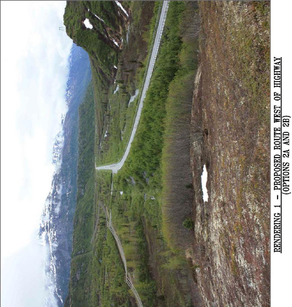
2 Table of Contents Executive Summary... 2 Background and Objectives... 2 Mitigation Options... 6 Evaluation of the Options List of Tables Table 1 Summary of Five Destructive Avalanches... 3 Table 2 Reliability Due to Avalanche Risk Scoring Table 3 Reliability Due to Non Avalanche Risk Scoring Table 4 Estimated Life Costs of Avalanche Mitigation Options Table 4a Summar of Initial Investment Costs Table 5 Cost Analysis Scoring Table 6 Initial Environmental Effects and Permitting Difficulty Scoring Table 7 Long Term Environmental Effects and Permitting Difficulty Scoring Table 8 Overall Ranking and Scoring of Options List of Figures Figure 1 Thompson Pass/Ptarmigan Creek Avalanche Area... 4 Figure 2 Existing and Alternative Routes... 9 List of Renderings Rendering 1 Proposed Route West of Highway (Options 2A and 2B) Rendering 2 Proposed Route Along Highway (Options 7A and 7B) Rendering 3 Proposed Highway Route (Option 7A and 7B) Looking Southwest Toward Worthington Glacier Prepared by: Greg Huffman, P.E., Dryden & LaRue Contributors: Dan Beardsley, Dryden & LaRue Del LaRue, P.E., Dryden & LaRue Doug Fesler, Alaska Mountain Safety Center, Inc Page 1
3 EXECUTIVE SUMMARY Copper Valley Electric Association, Inc. (CVEA) commissioned Dryden & LaRue, Inc. to review, analyze, and recommend avalanche mitigation alternatives for CVEA s 106 mile long Solomon Gulch transmission line. The primary focus of this study is a four mile section of the transmission line traversing the Thompson Pass area. Five times since 1986, avalanches have destroyed towers and caused sudden outages in the Thompson Pass area of the 138 kv Solomon Gulch transmission line. Each destructive event requires more generation in the Copper Basin area, effects CVEA s hydroelectric generation dispatch, requires expensive repairs, and places field personnel in jeopardy. Avalanche mitigation options have been identified and studied numerous times under previous ownership for this problem, but due mostly to the expense to construct and maintain solutions, nothing has been done to date other than preparing for the next destructive avalanche. In 2009, CVEA acquired ownership of the transmission line and resolved to find long term solutions to mitigate or eliminate the avalanche risk. After seeing only one destructive avalanche in the line s first 19 years of existence, four damaging avalanches have occurred in the last 11 years. If the recurrence interval of damaging avalanches seen in the last decade continues in the long term, it now makes economic sense to act. We believe there are several mitigation options that will significantly improve reliability over the present donothing approach while minimizing the economic impact over the expected life of the line. Considering reliability, life time costs, environmental effects, and permitting difficulty, we believe the preferred option is to relocate the section of line that now exists on the east side of the Richardson Highway down into either Alaska Department of Transportation and Public Facilities (DOT/PF) right of way or across the highway onto Alaska Department of Natural Resources Division of Land, Mining and Water (DNR) lands in the valley on the west side. If located in the highway right of way, structures should be self supporting steel poles at deadend, angle and avalanche risk locations, and either wood poles or steel poles elsewhere. If located west of the highway, wood H frame structures have been recommended over steel structures. These three options; along the highway using a combination of steel and wood poles, along the highway using all steel poles, and west of the highway using wood H frame structures, were evaluated to essentially be equivalent in overall preference. We recommend a detailed routing and permitting effort be initiated for these options to relocate the line. Once permitting difficulties and special stipulations have been established for the options, the preferred route can be selected and final design initiated. The estimated upfront costs of these options to relocate the line vary from $2.5 million, $2.7 million, and $3.3 million respectively for the options using wood and steel structures along the highway, wood H frame structures along the western valley, and all steel structures along the highway. These costs include materials, labor, retirement, permitting, engineering, construction, construction management and administration. Page 2
4 BACKGROUND AND OBJECTIVES The Solomon Gulch 138 kv transmission line was constructed in 1981 to connect the Solomon Gulch hydroelectric plant to the Copper Basin, approximately 106 miles away. The line generally follows the Richardson Highway through deep glacial valleys of the Chugach Mountains. The combined effects of terrain, weather, and climate produce a deep and often unstable snow cover in the mountain areas that is highly susceptible to frequent and sometimes extensive avalanche activity. Since 1986, no less than six avalanche occurrences have taken the line out of service for extended periods. All but one of these avalanches occurred in the Thompson Pass area between MP 27 and 30 on the Richardson Highway. The last four avalanches taking the line out in Thompson Pass have occurred in three to four year intervals. Table 1 summarizes the five destructive avalanches that have occurred to the line in the Thompson Pass area. Table 1 Summary of Five Destructive Avalanches Date Towers Damaged by Avalanche Repair Period Repair Cost December * 39 Weeks $1,500,000 January , Weeks $350,000 January /2 7 Weeks $280,000 February /3 4 Weeks $340,000 December /3 5 Weeks $205,000 *The 1988 avalanche directly hit and carried Tower feet downhill. Six adjacent towers were also damaged due to the high strength conductor not breaking. The high strength conductor has since been replaced with a weaker conductor in this area. When the line is out, more energy, at a greater expense, must be generated in the Glennallen Diesel Plant and prolonged transmission line outages may affect CVEA s ability to utilize all of the hydroelectric reserves contained in Solomon Gulch. Line repairs resulting from avalanche damage are expensive because they are unexpected, urgent, and must be performed during adverse winter conditions. Furthermore, all personnel on site are exposed to additional avalanches and other risks associated with steep terrain and deep snow. Several avalanche studies have been provided for the Solomon Gulch transmission line, the first being provided in 1981 during the design/construction phase, and the last, and most comprehensive, being provided in The 2003 study identified several options for mitigating avalanche risk to the line and, using weighted criteria, included ranking the options by a six member committee consisting of representatives from the owner and the operating utility, and specialists in avalanche hazards, transmission engineering, and environmental/permitting issues. This report specifically addresses Towers 43 6 to 47 8 in the Thompson Pass/Ptarmigan Creek portion of the Solomon Gulch 138 kv transmission line, a distance of 4.2 miles along the existing alignment. Approximately 3.4 miles of these are exposed to dozens of interconnected paths in several distinct avalanche areas (see Figure 1). Since the 2003 study was published, two avalanches have taken the line out. Also, on February 24, 2009 CVEA acquired the Solomon Gulch project from the Southeast Alaska Power Agency (SEAPA), formerly the Four Dam Pool Power Agency. Page 3


5 Figure 1 Thompson Pass/Ptarmigan Creek Avalanche Area MP OUTSIDE OF STUDY AREA Ptarmigan Drop OUTSIDE OF STUDY AREA MP 29 Worthington Flats Avalanche Area A l h A MP The Bulge Avalanche Area 29 Mile Avalanche Area 44-5 School Bus 27 Mile 43-6 A l h A A l h A 27 Mile Camp A l h A Lake Corner A l h A MP Odessey Avalanche Area OUTSIDE OF STUDY AREA 43-1 To Valdez Potential Avalanche Hazard Areas 43-1 Transmission Line Structure Numbers Direction of Avalanche Flow & Impact MP 27 Richardson Highway Mile Posts Solomon Gulch 138 kv Transmission Scale: Grids: 1 square mile; Contour Intervals: 100 feet Source Map: USGS Valdez A 5, 1:63, Alaska Mountain Safety Center, Inc N Page 4
6 This report will not discuss snow avalanche characteristics or specific avalanche exposures in the study area. The reader is referenced to the 2003 study for a thorough discussion of these topics. The same definitions of risk categories and risk index (RI) used in the 2003 report will be used in this report and are repeated here. The risk of damage or destruction to transmission line structures and conductors in the study area are divided into four categories of risk: Low, Moderate, High or Unaffected according to the following definitions: High Risk: Five or more potentially destructive avalanches are expected to impact a given structure location during any 50 year period, and avalanche pressure thresholds are likely to exceed the maximum design strength of the current structures, likely resulting in severe damage or destruction. The mean return interval equals 10 years or less (i.e. a 10% or more annual probability of encounter). The avalanches may involve debris and/or powder blast components. Moderate Risk: One to four potentially destructive avalanches are expected to impact a given structure location during any 50 year period, and avalanche pressure thresholds are likely to exceed the maximum design strength of the current structures, likely resulting in severe damage or destruction. The mean return interval equals 25 years or more (i.e. a 4% or less annual probability of encounter). The avalanches may involve debris and/or powder blast components. Low Risk: Regardless of avalanche frequency or magnitude, one or more non destructive avalanches are expected to impact a given structure during any 50 year period, but because the maximum design strength of the structures exceeds the avalanche pressure thresholds, no significant damage to the system will be likely. This category applies to two situations: a) structures located in small avalanche paths repeatedly hit by shallow debris from frequent, small avalanches; and b) structures located in or near the extreme limits of an avalanche run out zone where, on rare occasion, are hit by powder blasts from a design magnitude avalanche, where most of the avalanche energy has already dissipated (i.e. a structure is dusted, but not damaged). Unaffected: As the label implies, these structures are located outside the range of avalanche impact and cannot be hit, damaged, or destroyed by avalanches. In summary, only structures rated as Moderate or High are susceptible to severe damage or destruction. Low risk structures may be hit, but are built strong enough to withstand the avalanche forces to which they are subjected. Unaffected structures cannot be hit, damaged, or destroyed. The percentage of risk reduction attributable to an individual mitigation option is described in terms of a risk index (RI). Previous avalanche studies for the Thompson Pass/Ptarmigan Creek area have normalized a RI value of 1.0 to a design magnitude avalanche with energy density of about 2,700 lbs/ft 2. The existing line in its unaltered state has a RI value or 1.0. Mitigation options with RI values less than 1.0 imply a reduction in exposure. Though the avalanche hazard may remain unaltered, a particular mitigation option may reduce the risk to a manageable level. Page 5
7 MITIGATION OPTIONS The 2003 study recommended the following six mitigation options be further considered: 1. Make no line modifications but establish a fund to finance future failures (Do Nothing Option). 2. Relocate the transmission line west of the Richardson Highway. 3. Install avalanche deflection structures adjacent to the transmission line structures. 4. Transfer the existing transmission structures to new high reveal foundations. 5. Combination of external (deflection structures) and internal (high reveal foundations) protection. 6. Daily avalanche maintenance forecasting and control. For relocating the line west of the Richardson Highway, we have evaluated two options. Option 2A uses wood H frame type structures and Option 2B uses tubular steel towers similar to the existing line. We have reduced to two the number of options involving mitigation work adjacent to or on existing structures. Since we believe a couple of the existing structures should be protected externally rather than internally, we ve not included the all high reveal, internal protection option. Option 3 uses external deflection structures at sites needing protection and Option 4 uses deflection structures only at two sites and high reveal foundations at all the other sites needing protection. Relocating the line underground was an option considered in the 2003 study, but was not ranked very high due mostly to high cost. Technical advancements, product competition and popularity of high voltage underground systems in recent years have seen a reduction in their costs. Underground options are also favorites of land owners/managers and the public. We therefore have included this option for re evaluation. We have also included overhead re route options along the Richardson Highway. This option was not included in the 2003 study because it did not eliminate avalanche risk. The rational was if the line is relocated, move it far enough west of the highway where the avalanche risk can essentially be eliminated. For this report, we have included two variations of an overhead highway route. Both use self supporting, tubular steel poles at deadend, line angle and avalanche risk locations. Thus there will be no guys or anchors along the highway, and steel pole structures will be designed to be avalanche resistant at locations with avalanche hazards. The difference between the two options is one uses wood poles where steel poles are not needed for strength (Option 7A), and the other option uses steel poles everywhere (Option 7B). Because there are few possibilities for improvement, the option of relocating structures within the existing right of way was not recommended for further consideration in 2003, and we therefore have not included it in this report. In all, 9 options are evaluated in this report. The following is a brief discussion of these options: Page 6
8 Option 1 Do Nothing Doing nothing implies an acceptance of the present level of risk. It means major avalanche events capable of destroying portions of the power line can be anticipated on a fairly regular basis. The 2003 study was based on a seven year return interval for destructive avalanches. Given the four destructive avalanches that have occurred in the Thompson Pass in the last 11 years, the current report is based on a three year return interval. Typical repair costs in today s dollars are $350,000 per event and typical outage time for each repair is approximately five weeks. Additionally, field personnel will still be at risk during the repair phase. The Do Nothing option is often initially the most attractive because it requires little effort and appears on the surface to be the least expensive but often it becomes much more expensive in the long term. This option provides no effective reduction in risk, maintenance or repair costs, down time, or exposure to field personnel. The RI value remains 1.0. Option 2A and 2B Relocate the Line West of the Richardson Highway Because the most reliable mitigation is avoidance, relocation to non exposed areas must be considered as the avalanche reliability yardstick by which all other mitigation options should be compared. Relocating the line to the valley floor to the western side of the Richardson Highway following the Trans Alaska pipeline avoids avalanche risk in the Thompson Pass area. A renowned avalanche expert, Doug Fesler, identified two alternate alignments for the 2003 study. Each of these routes has advantages over the other. Route A is largely hidden from public view behind the old terminal moraine mounds located mid way between the highway and Worthington Glacier. Though this route is aesthetically more pleasing, it impacts an area not previously disturbed, provides slightly more difficult access for construction and maintenance, and crosses the pipeline at two locations. Route B, on the other hand, is more visible from the highway, but provides easier construction access and does not require a pipeline crossing. See Figure 2 for locations of these two routes. For this report we evaluated two structure options for Route B; Option 2A uses wood H frame type structures and Option 2B uses tubular steel towers similar to the existing structures. Options 2A and 2B will require approximately 27 new structures. We believe Route A would score very similar to Route B, and should not be dismissed. If either Options 2A or 2B proves to be the preferred option, a more detailed comparison of the two routes is warranted. Relocating the line on the west side of the highway using steel structures and retiring the existing line is estimated to cost approximately $4.3 million, including permitting, engineering and administration. This estimate is based on using all new structures and will require approximately three weeks of outage time. The cost could be reduced by about $300,000 if the old structures are used on the new alignment, but this would require about four more weeks of outage time if the existing line can be retired at the same time the new line is constructed. This might not be practical because new construction is best suited for the summer time and retirement of the existing line is best suited for winter time due to access issues. Costs for these routes could be further reduced if new wood H frame structures are used in lieu of steel structures. However, reliability would be reduced and maintenance costs would likely increase. If wood structures are used for this route, we estimate construction cost will be approximately $2.7 million, including permitting, engineering and administration. Page 7

9 The obvious advantage of these options is they are not exposed to any avalanche risk. Additionally, these routes will be more concealed from the highway than the existing line, and will be easier to access due to not having to cross Ptarmigan Creek. See Rendering 1 at the end of this report for a conceptual rendering of Options 2A and 2B looking northeast from a knoll west of the Richardson Highway. The disadvantages of these options are construction costs and the uncertainties and costs associated with the environmental studies and permitting process required to vacate the old right of way and obtain a new one. The new alignment would cross the Worthington Glacier access route, the main reason why the line was originally located on the east side of the highway. The new alignment will also cross open areas popular with winter recreational users. New land use and construction permits will be required from the Alaska Department of Natural Resources (DNR) which will require a public review and input process. Though less visible from the highway than the existing line and not likely to interfere with a view of the glacier, public objection and permitting challenges are highly likely with these reroutes. Option 3 Defense Structures Built Adjacent to Existing Structures Direct protection structures suitable for transmission towers include splitting wedges and impact structures built using steel piles and beams, reinforced concrete, or earthenfilled wood crib construction. Dryden & LaRue recently designed a splitting wedge structure to protect a lattice tower on the Snettisham 138 kv line near Juneau, Alaska. It consists of tube steel members welded to 4 ft. diameter, vertical pipes. It is 40 ft. tall, has a 45 ft. and a 60 ft. long wall, and is designed to resist 5,000 psf flowing avalanche forces. It is located on steep rock faces only accessible by helicopter. It cost nearly $2 Snettisham Splitting Wedge Structure million to construct this single defense structure. The strongest splitting wedge defense structures for Thompson Pass structures will need to be approximately 25 ft. tall and designed to resist 2,700 psf avalanche forces. Wheeled or tracked vehicle access during construction would be anticipated. So with better access, smaller size and less load, they will not be nearly as expensive as the Snettisham wedge. We estimate construction cost for splitting wedges for the 10 greatest risk and four less risk Thompson Pass structures will average $215,000 each. Total cost, including permitting, engineering and administration, is estimated to be $3.7 million for this option. The advantage of defense structures is they can be built within the existing right of way with only access permits and minimal environmental review anticipated. They require little space to build, can be constructed with readily available materials, and no disruption to the transmission line is required. Page 8

10 Page 9
 leg, and down guys should be either protected, designed to break away, or designed to resist avalanche forces.")
11 The disadvantage is cost, which can exceed the cost of a transmission structure, and the fact the risk cannot totally be eliminated. Each tower leg must be protected, not just the leading (uphill) leg, and down guys should be either protected, designed to break away, or designed to resist avalanche forces. Summer construction is anticipated so access restrictions and stipulations will definitely impact construction cost. Option 4 High Reveal Foundations In lieu of external protection, such as splitting wedge structures, internal protection of existing structures may be used to withstand design magnitude avalanche forces. A likely scenario for strengthening the line would involve constructing new, high reveal, very strong foundations where the existing structures could be transferred. Elevating the transmission line structures and conductors will also reduce the powder blast forces on them. The structures likely would not require modifications if they Snettisham Splitting Wedge Structure were installed above the flowing avalanche. There are two sites where external (splitting wedge) protection is still preferred over high reveal foundations. Structure #44 6 is a critical, in line deadend X tower with fore and aft brace legs. It is the only deadend structure recommended to be protected. Although probably a little more expensive to construct, we would recommend this structure be left alone and a strong defense structure be constructed uphill from it. Deadend structures are critical to the lines mechanics, and losing it either during construction or due to an avalanche might have catastrophic consequences to adjacent structures. Structure #45 6 is a Y tower with only one foundation, albeit a strong moment resisting one. We estimate constructing a splitting wedge structure to protect one structure shaft is more economical and preferred over constructing a new high reveal, moment resisting foundation. The advantages of high reveal foundations include confined construction areas, construction remaining in the existing right of way, minimal anticipated environmental review and permitting, and reduced powder blast forces on the conductors. The disadvantages of Option 3, i.e. cost and non elimination of risk, also apply to Option 4. Internal protection has additional disadvantages when compared to external protection. Elevating the line will make it more noticeable from the highway and outages will be required during construction. Also, an avalanche with forces in excess of the design magnitude event could potentially result in severe damage, power interruption, and costly, urgent repairs. The same avalanche hitting an external protection structure might only damage the external structure, but keep the line intact. If only the external structure is damaged, repairs would be less expensive and non urgent. Page 10
12 Total cost for Option 4 is estimated to be $3.7 million, or essentially the same as Option 3. But unlike Option 3, Option 4 will require an estimated six weeks of outage time. Option 5 Avalanche Forecasting and Control Avalanche hazard forecasting is the process of integrating assessments of terrain capability, snow stability, and weather effects to anticipate avalanche activity, estimate run out distances, evaluate the potential threat to personnel and structures, and implement avalanche control or other appropriate mitigation measures to reduce the risk. Avalanche control, whether by artillery, helicopter bombing, or some other means, is the process of artificially releasing avalanches with the intention of bringing down relatively small slides that clean out most of the unstable snow, but stop short of impacting the power line being protected. To be effective, any kind of avalanche control must be carried out on a consistent basis during periods of instability throughout the entire winter season. The risk of releasing larger than anticipated deep avalanches increases significantly if control operations are delayed, if they are conducted after multiple storms have distributed deep accumulations of snow in the starting zones, or if snow conditions in the paths are more unstable than anticipated. Conversely, by not timing control operations to coincide with the periods of instability, results are likely to be negligible (i.e. time, money, and effort might be wasted). Other limitations of such a program would be the unavailability of artillery and ammunition, reliance upon helicopters as the main means of delivering explosives to the starting zones, and the difficulty of getting or keeping qualified avalanche professionals. The primary weakness of helicopter reliance is the inability to fly during periods of bad weather, the very time when avalanche conditions might be critical. Other problems are licensing/permitting, explosive storage, liability, and environmental impacts. The licensing and permitting process for explosive transport, storage, and use became considerably more involved and expensive after the September 11, 2001 terrorist attacks. Future restrictions might be imposed on explosives that make their use more difficult or expensive, or even impossible. Either a secure explosive storage area would have to be constructed or an agreement to DOT/PF s explosives caches would have to be arranged. There are also usually increased liability (insurance) costs associated with explosives and helicopters. Environmental impacts of avalanche control are not negligible. Each explosion leaves the snow surface (and subsequently the ground surface) coated with chemical residue and debris, which can be harmful to humans, wildlife and plant life. It is not unusual for avalanche control operations using explosives to occasionally have a dud (explosive device that did not detonate). These pose a risk to people until they are detonated or removed. Risk is involved in removing them, not only from the devise itself, but also from avalanches and terrain hazards. Artificially releasing avalanches in the Thompson Pass area will require close coordination with DOT/PF, and likely highway closures. On the positive side, avalanche control is the only option that requires no construction and yet still reduces risk. It can also be applied to other sections of the Solomon Gulch project at little extra cost. Avalanche forecasting and control programs are popular for protecting roads and ski areas. However, there is a significant difference when used to protect a power line. When used to protect roads and public areas, the areas are closed to traffic and people while releasing avalanches, thus Page 11
13 there is usually little concern about releasing too big of an avalanche. But when used to protect a power line, the structures cannot be removed from the avalanche zones. The artificially released avalanche has the potential to damage the structures. Alaska DOT/PF currently uses avalanche forecasting and control to mitigate avalanches from reaching the Richardson Highway. They regularly shoot artillery from the turnout near Summit Lake (Structure #44 3), targeting the School Bus Avalanche area. Although not an objective of DOT/PF, their actions to protect the highway usually also protect the power line. However, they might also inadvertently jeopardize the line by releasing an avalanche that damages structures. New innovations for releasing avalanches include controlled explosive devices that generate shock waves by combusting a hydrogen/oxygen mixture. These devices can either be permanently installed on mountain sides and remotely activated, or suspended from helicopters and flown over starting zones. Both Alyeska Ski Resort (Girdwood, Alaska) and Alaska Electric Light & Power (AEL&P) (Juneau, Alaska) have recently purchased the Daisybell device which incorporates this technology and is carried by helicopter above the snow surface. Additionally, AEL&P has hired a full time avalanche expert. His primary responsibilities are forecasting and controlling avalanches along the Snettisham transmission line, but that role consumes only a fraction of his yearly employment. In order to keep him on staff, AEL&P tasks him with other utility work when he is not working avalanches. The initial investment and setup cost for a Thompson Pass avalanche hazard and management program involving forecasting and control is estimated to cost approximately $250,000. The seasonal cost of such a program is estimated at $250,000 to $300,000 depending upon the severity of the season. This includes avalanche forecasters for 24/7 coverage, explosives or combusting materials, helicopter and transportation, housing, and safety training. A joint program with DOT/PF may be possible for this portion of the line and may reduce costs by $80,000 to $120,000 per season. The RI value for a top notch avalanche forecasting and control program would be approximately 0.2 over the long term. It is important to remember an avalanche control program, no matter how well intentioned and managed, has the potential to trigger avalanches larger than intended, thus creating the possibility of damaging the very facilities that were intended to protect. Options 6 Relocate the Line Underground While the benefits from underground construction are obvious from an avalanche perspective, this option is very expensive to construct. It would not be practical to install an underground line in the high risk areas of the existing right of way due to the extremely difficult terrain. The most likely location for an underground line would be along the Richardson Highway. New deadend/riser structures would be installed where the existing overhead line crosses the highway; between Structures #44 2 and #44 3 on the south end and Structures #47 2 and #47 3 on the north end. The underground alignment would be approximately 3.1 miles long, cross several creeks, and require a significant permitting and DOT/PF coordination effort. Advances in high voltage cable technology, increased popularity, and product competition have caused underground transmission costs to decrease in recent years. We have talked to cable manufacturers and contractors and have identified two feasible underground construction Page 12
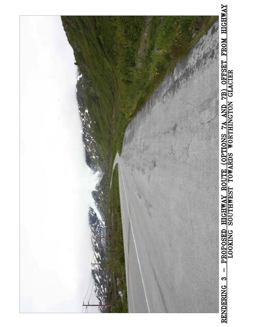
14 alternatives. One alternative uses the more traditional installation of cables inside conduits. A trench would be dug, four 6 inch conduits laid, and the trench backfilled. Vault spacing is controlled by cable pulling strength. For this project, we estimate typical vault spacing will be about 1,200 ft., resulting in 14 vaults for the underground alignment. Single cables would be pulled between vaults through three conduits and spliced to adjacent sections inside the vaults. The fourth conduit is a spare. Most utilities leave it empty until one of the cables experiences a fault, at which time a new cable would be pulled through the spare conduit and spliced in. Lead times for this size cable are fairly long, so it may be prudent to have spare cable on hand, or optimize preparedness even further by installing it in the fourth conduit during construction. The second alternative uses direct buried cable where the cable is installed directly in the trench without conduits. The cable has a heavy outer shield that helps protect it from backfill and dig ins. Because the cable does not have to be pulled through conduit, vaults can be spaced further apart, resulting in less vaults and splices. We estimate vault spacing would average about 2,000 feet, resulting in nine vaults for the direct buried option. Four cables, one of which would be a spare, would be installed in the trench and terminated on the riser structures. The advantage of this alternative is its cost savings and having a readily available spare cable. It also has fewer splices, which are common fault locations. The disadvantages include having to leave the entire trench open between vaults for several days during construction in order to install all four cables. Direct buried cables are also more vulnerable to dig in damage. Both conduit encased and direct buried cable systems can be backfilled with concrete for added protection. We estimate the construction cost of a conduit encased underground system to be $7.2 million including removal of the existing overhead line. This same option was estimated to cost $7.8 million in Purchasing spare cable for the full alignment length will add about $1.0 million, and installing the spare cable during construction will add another $400,000. Adding permitting, engineering, and managements costs, the no spare, spare in storage, and spare installed variations of this alternative are estimated to cost $9.0, $10.0, and $10.5 million respectively. The directburied with spare installed alternative is estimated to cost $8.2 million including permitting, engineering and management. Because of the cost savings and readily available spare cable, we ve only further considered the direct buried alternative, identified as Option 6. We estimate four weeks of outage time will be required to construct this option. Our evaluation for an underground line assumes the line can be built in road fill material, which means it is essentially along the highway shoulder. If DOT/PF objects to having the line this close to the highway, winter construction and/or directional boring techniques will be required to install the line underground through wet areas. This will significantly increase the construction cost. Option 7A and 7B Relocate the Line Overhead Along the Highway These options relocate the line from the high avalanche areas on the east side of the Richardson Highway down to and along the highway. Like the underground options, the new alignment will intersect the existing line at two locations where it crosses the highway approximately 3.1 miles apart. We have identified a likely alignment based on desirable locations to intersect the existing line, terrain, highway alignment, avalanche risk and other factors. The re route would begin underneath the existing line on the east side of the highway in the turnout area adjacent to Summit Lake. It would traverse north on the east side of the highway for about a 1,000 feet and then cross Page 13
15 the highway to the west side. It will follow the highway on the west side for two plus miles, occupying upper elevations of cut areas, but staying within the DOT/PF right of way. Near the access road to the emergency air strip on the west side, the alignment will cross back over to the east side of the highway and follow the highway the final three quarters of a mile to the existing line. This alignment will increase overhead highway crossings from two to four in the Thompson Pass area, which is more an aesthetic issue than a design issue. Being on the east side of the highway for the last three quarters of a mile will have poorer ground conditions and slightly more avalanche risk than being on the west side. However, we believe it will be better to be on the east side in order to stay away from the FAA listed emergency air strip located a couple hundred feet from the highway on the west side. Relocating the line to the highway does not eliminate avalanche hazard. Avalanches cross the highway on average every few years, despite the DOT/PF s efforts to forecast and control them. For an option to be considered avalanche reliable along the highway, structures must be selectively located and/or designed to resist avalanches of magnitudes expected to reach them. The two options along the highway will require approximately 39 new structures. Both options use selfsupporting steel poles where the line deadends or turns an angle (approximately 10 locations) and at locations with avalanche hazards (approximately 10 additional locations). Option 7A uses wood poles for the remaining 19 tangent applications whereas Option 7B uses steel poles at these locations. Typical pole heights for both options are estimated to be 60 feet above ground based on providing ground clearance above approximately ten feet of snow cover. Estimated construction cost for Option 7A is $2.6 million and estimated cost for Option 7B is $3.3 million, including permitting, engineering and management. Both options are estimated to require approximately four weeks of outage time during construction. The advantages of these options are significant reduction in avalanche risk and the line will be more accessible for maintenance and repairs. The disadvantages are cost and an increased exposure to the public s view. There is also an increased risk to the line due to damage from vehicles. Rendering 2 shows what Options 7A and 7B might look like from the same perspective as Rendering 1, which shows Options 2A and 2B. Rendering 3 shows Options 7A and 7B looking southwest towards Worthington Glacier from the north end of the reroute. These renderings can be found at the end of this report. EVALUATION OF THE OPTIONS All 9 options discussed above have their advantages and disadvantages. Selecting a preferred option is highly dependent on the evaluation criteria and how the criteria is scored and weighed. Criteria for evaluating the options include system reliability, both from avalanche risk and other risks, life costs, environmental effects, and permitting difficulties. These criteria are by no means the only considerations for selecting a preferred option, but they are the major deciding factors. Other criteria include construction risk and ease of maintenance. However, we find these criteria have less significance, are similar for all the options, or have already been compensated for in the reliability and cost criteria. Since scoring the options and weighing the criteria are subjective, it Page 14
16 would be prudent to consider these lesser criteria in order to tip the scale when deciding the preferred option over other closely scored options. Evaluation criteria are not created equally and they should therefore not carry the same weight. The difficulty here is that everyone has a different opinion on how the weight should be distributed. We believe total reliability should be the number one weight contributor, followed by lifetime costs, and environmental/permitting considerations. The following is our proposed evaluation criteria and importance weighing using a 100 point scoring system: System Reliability due to Avalanches Risks points System Reliability due to Non Avalanches Risks points Life Cycle Costs points Initial Environmental Effects and Permitting Difficulties..15 points Long term Environmental Effects and Permitting Difficulties 15 points Total: 100 points The following are definitions of the criteria as they apply to this project and a discussion of relative rankings/groupings of the options for each of the main evaluation criteria. At the end of each discussion we have included our subjective scoring of the options based on the point value assigned to the criterion. System Reliability due to Avalanche Risk: This addresses the ability of a proposed option to reduce the negative impacts of all anticipated avalanche events and the probability that the proposed option will function as intended. The RI value attributed to the options is a comparative measure of avalanche impact reduction. The following grouping of the options considered this reduction along with how well we believe the option will perform as intended. The two options (Option 2A and 2B) to relocate the line to the west side of the highway are considered to have the highest system reliability due to avalanche risk. At these locations, the risk is essentially eliminated and the probability that their avalanche mitigation will function is high. The next level of reliability is the underground option (Options 6). The section that would be installed underground would actually have higher avalanche reliability than relocating the line overhead west of the highway, but the underground option retains a few avalanche risk structures west of the highway that Options 2A and 2B relocate to no risk areas. Options 7A and 7B, relocating the line along the highway using avalanche resistant steel structures at locations with avalanche risk, are judged to be next in avalanche reliability ranking. The two options (Options 3 and 4) to provide internal or external protection to the line in the existing right or way have less avalanche reliability because of concerns with their performance. The avalanche risk can be significantly reduced or eliminated in theory by building defense structures or elevating the existing structures on high reveal foundations. However, there are uncertainties and potential errors associated with predicting avalanche forces. These concerns carry over to the design and construction of the structures to resist these forces. Option 3, Defense Page 15
17 Structures adjacent to the towers is ranked a little more reliable than the option involving internal protection because it can sustain avalanche damage without necessarily damaging the transmission line. Option 5, avalanche forecasting and control, is estimated to have a RI of 0.2. It is evaluated fairly low because of the many variables and potential problems with a human reliant intervention program. Obviously, the do nothing option (Option 1) is last on the list of avalanche reliability. Table 2 Reliability Due to Avalanche Risk Scoring (25 possible points) Rank Option Score 1 2B Relocated line to West Route using Steel A Relocate Line to West Route using Wood Relocate Line Underground by Direct Burying B Relocate Line to Highway using Steel Poles A Relocate Line to Highway using Wood and Steel Poles Defense Structures Adjacent to Existing Towers Combination of Defense Structures/High Reveal Foundations Avalanche Forecasting and Control Do Nothing 2 System Reliability due to Other Risks: This addresses the ability of a proposed option to minimize the negative impacts of aging and risk events other than avalanches. Generally speaking, new line sections will be more reliable than the existing line, which has been in service for nearly 30 years. Relocating the line using steel structures is considered to have the highest reliability. Relocating west of the highway (2B) is considered more reliable than relocating along the highway (Option 7B) because there are fewer old structures, fewer total structures, and no potential for vehicle collisions along the highway. Relocating the line using wood poles is considered to have similar reliability than options continuing to use existing structures. Wood structures are considered less reliable and have less life expectancy than steel structures. Direct embedded wood pole foundations are also susceptible to cold region problems such as frost jacking and permafrost degradation, although these concerns are expected to be minimal in the Thompson Pass area. But the options that continue to use the existing line (Options 1, 3, 4, and 5) are highly dependent on the line s 30 year old age. Not counting avalanche events, the existing line has been very reliable, and there is no foreseeable need to replace it due to age. However, 30 years of use in the extreme environment of Thompson Pass, including being slammed by several avalanches that may have caused undetected damage, must be considered in evaluating the reliability of these options. Page 16
18 The options to add mitigation measures in the existing right of way, Options 3 and 4, continued to use the existing line, and also add new facilities to maintain and rely on. Therefore options adding defense structures or high reveal foundations will be less reliable than the options with no new construction. The reliability of high voltage underground lines is generally considered less reliable than overhead lines because of potential material, design and construction deficiencies, and the long outages needed to repair them. Having a spare cable in place increases the reliability, but in the event of a fault, still requires outage time for repairs and expensive replacement of damaged sections to reestablish the same level of reliability. Also, drainage, icing, and ground heaving are serious concerns in the Thompson Pass area for underground systems. Of particular concern is accumulation of water in the vaults and damage resulting from freeze thaw cycles. Thus, direct burying the line underground (Option 6) is considered less reliable than all the overhead reroute options. Table 3 Reliability Due to Non Avalanche Risk Scoring (15 possible points) Rank Option Score 1 2B Relocate Line to West Route using Steel Poles B Relocate Line to Highway using Steel Poles A Relocate Line to West Route using Wood Poles A Relocate Line to Highway using Wood and Steel Poles Do Nothing 8 5 Avalanche Forecasting and Control Defense Structures Adjacent to Existing Towers 7 4 Combination of Defense Structures/High Reveal Foundations Relocate Line Underground by Direct Burying 5 Life Cycle Costs: This criterion is the economical piece of the evaluation. It includes the cost of the initial investment, and present value costs for annual maintenance and lifetime avalanche repairs. The initial investment includes estimated costs for implementing, permitting, performing environmental studies, engineering, procuring materials, constructing, construction management, and administration for the options. Administration/overhead costs were assumed to be 15% of all other initial costs. Annual cost is the average estimated cost to maintain the line and the avalanche mitigation facilities or program, excluding repairing major avalanche damage. Avalanche repair cost is the estimated average cost to repair avalanche damage to the line or mitigation facility, including administration and management costs every time a destructive avalanche occurs. Present values for annual costs and avalanche repair costs are calculated using an assumed annual net return rate of 2.5% (interest less inflation). Estimated avalanche repair intervals were used to calculate present values for Page 17
19 avalanche repair costs. These repair intervals are our estimate of the average recurrence interval or repairing damage to the line or mitigation facility caused by avalanches. They range from three years for the do nothing option to 100 years for options relocating the line to the west side of the highway. Table 4 summarizes the cost estimates, repair intervals, and present value costs for the options. Table 4a summarizes the initial investment costs of the options. The reader is cautioned that the values listed in these tables are dependent on many variables and assumptions. Changes to any of these might affect the scoring. It is noted that cost to generate power from the Glennallen Diesel Plant and the potential impact of not fully utilizing Solomon Gulch while the 138 kv line is out, whether during initial construction or during avalanche repairs, have not been included in the life cycle costs. Page 18
20 Table 4 Estimated Life Costs of Avalanche Mitigation Options O & M Cost Avalanche Repair Option Initial Investment Annual Life Time Interval Cost Qnty. Life Time $ Present Value 1 - Do Nothing $0 $25,000 $537,055 3 years $350, $3,366,5 70 $3,903,624 2A - Relocate Line to West Route B using Wood $2,715,610 $20,000 $429, years n/a 0 $0 $3,145,254 2B - Relocate Line to West Route B using Steel $4,303,076 $15,000 $322, years n/a 0 $0 $4,625, Defense Structures adjacent to Towers 4 - Combination of Internal/External Protection 5 - Avalanche Forecasting and Control $3,739,800 $30,000 $644, years $550,000 2 $565,822 $4,950,088 $3,704,725 $30,000 $644, years $550,000 2 $565,822 $4,915,013 $250,000 $300,000 $6,444, years $350,000 3 $626,925 $7,321, Relocate Line Underground via Direct Buried $8,143,495 $10,000 $214, years $300,000 1 $113,352 $8,471,669 7A - OH along Hwy. - Wood and Steel Poles 7B - OH along Hwy. - All Steel Poles $2,515,779 $20,000 $429, years $225,000 1 $122,462 $3,067,884 $3,300,746 $15,000 $322, years $225,000 1 $122,462 $3,745,441 Assumptions: Annual interest rate = 4% Annual inflation rate = 1.5% Project life = 50 years First avalanche repair occurs approximately half the interval from the present, and then every interval period thereafter. Page 19
21 Table 4a Summary of Initial Investment Costs Option Material Labor Retirement Perm., Eng., Mgmt., Total 1 Do Nothing $0 $0 $0 $0 $0 2A Relocate Line to West Route B using Wood $517,450 $1,130,150 $268,800 $799,210 $2,715,610 2B Relocate Line to West Route B using Steel $1,337,505 $1,630,500 $268,800 $1,066,271 $4,303,076 3 Defense Structures adjacent to Towers $1,652,800 $1,289,200 $0 $797,800 $3,739,800 4 Combination of Internal/External Protection $894,300 $1,987,200 $0 $823,225 $3,704,725 5 Avalanche Forecasting and Control $50,000 $150,000 $0 $50,000 $250,000 6 Relocate Line Underground via Direct Buried $4,576,800 $1,857,500 $177,000 $1,532,195 $8,143,495 7A OH along Hwy. Wood and Steel Poles $537,734 $1,112,900 $177,000 $688,145 $2,515,779 7B OH along Hwy. All Steel Poles $757,314 $1,595,900 $177,000 $770,532 $3,300,746 Based on the above cost analysis, the options are scored and ranked in Table 5 Table 5 Cost Analysis Scoring (30 possible points) Rank Option Score 1 7A Relocate line to Highway using Wood and Steel Poles A Relocate Line to West Route using Wood Poles B Relocate Line to Highway using Steel Poles Do Nothing B Relocate Line to West Route using Steel Poles Combination of Defense Structures/High Reveal Foundations Defense Structures Adjacent to Existing Towers Avalanche Forecasting and Control Relocate Line Underground by Direct Burying 1 Permitting Difficulties and Environmental Effects: Permitting difficulties addresses the degree of difficulty associated with obtaining the permits needed to construct and operate the transmission line and avalanche facilities or programs. Consideration is given for the number of permits required, and the risk obtaining a permit might delay the project or the project would be allowed to proceed only after significant modifications are made. Environmental effects addresses the quantity and degree of significance of the negative effects an option has on the soil, water, traffic, recreation, and aesthetic resources of the project area. Environmental effects include those associated with both the construction and operation of the system. Page 20
22 Permitting difficulties and environmental effects are not unrelated and in fact follow the same ranking patterns. For this reason we ve chosen to include both in the same criteria. However for scoring purposes, we believe it s worth distinguishing the combined difficulties, effects and risks into an initial and life span criterion. The initial criterion includes all the permitting difficulties and negative environmental effects associated with new construction or programs, whereas the lifespan criterion includes those that can be expected over the life of the project. Aesthetic and recreation issues, for example, are environmental issues that might have long term effects to a project, but they are considered mostly an initial concern because once a new project is assessed, scrutinized and permitted, these issues are no longer considered a difficulty or risk. Before assessing permitting risks, a brief discussion of the current land use, and the relevant land use and regulatory permitting requirements is in order. Thompson Pass Land Use: Except for the Richardson Highway right of way, maintenance camp and the Worthington Glacier State Recreation Site (Park) located in U.S. Survey 3577, the lands in Thompson Pass are under the management of the DNR. DOT/PF's Richardson Highway Right of Way was 150 feet each side of the original centerline of the highway as constructed across Thompson Pass. Portions of the highway were relocated in the late 1970s or early 1980s within an intra agency land management transfer (ILMT) issued by DNR to DOT/PF. Between Glennallen and Valdez the Richardson Highway has been designated as a Scenic Highway. No management plan has been adopted for the Richardson Highway Scenic Highway. The Alaska Division of Public and Outdoor Recreation (State Parks) manages the Park under an ILMT issued by DNR. Thompson Pass is a special use area that designated the Pass as a recreational area. That designation also allows DNR to enforce safety measures within the special use area. Recreation users have also obtained permits for various activities in Thompson Pass. These include permits for support activities, events and land use for several backcountry skiing outfits as well as a local snowmachine organization. Alyeska Pipeline Service Company's (APSC) pipeline and several access roads occupy the westerly side of the Pass by virtue of a lease from the DNR. CVEA's existing transmission line easement was issued by DNR subject to concurrence of Alyeska Pipeline Service Company (APSC) under a letter of nonobjection (LNO). A 2,500 foot, Federal Aviation Administration (FAA) listed, emergency airstrip parallels the highway at the north end of the study area. Copper Valley Telecom (CVT) and GCI Fiber Communication Company, Inc. (GCI) have fiber optic cables located along the westerly edge of the DOT/PF right of way. Land Use Permits Required: For those facilities constructed within or crossing the Richardson Highway right of way, DOT/PF will require a major utility permit. Outside of the Richardson Highway right of way, DNR will require an easement to cross the DNR lands. Any construction or maintenance access outside of the existing CVEA easement, the highway right of way or a new DNR easement will require a land use permit from DNR. All facilities constructed within U.S. Survey 3577 will require the specific concurrence of State Parks. Facilities constructed adjacent to or across the APSC easement will need to comply with the terms of the LNO. In the event of conflicts with CVT and GCI fiber optic cables, the communication utilities non objection will be required and the cables will need to be relocated as necessary. DOT/PF does not as a general rule require public notice for issuance of major utility permits; however, with the Scenic Highway designation there is the potential that DOT/PF may notify the public of the proposed permitting effort on its Scenic Highway Website. DNR's easement process Page 21
23 does include public notice. With the number of user groups for this recreational area and potential impacts to the parks, DNR will likely require a major public information process with hearings to allow affected users an opportunity to provide their comments. Regulatory Permits Required: Three major regulatory permits may be required for new construction, a Corps of Engineers (COE) wetlands permit, a FAA Notice of Proposed Construction for structures near the airstrip and an Environmental Protection Agency (EPA) Notice of Intent (NOI) if greater than an acre of land is disturbed. Any new construction occurring in wetlands will require issuance of a COE Nationwide No. 12 Permit. It is possible the COE may require a general permit for installation of buried line, Option 6, depending upon the quantity of land affected and the impacts to the wetlands. FAA requires a Notice of Proposed Construction for any structures proposed within vicinity of an airport. As a FAA listed, emergency airstrip, notices will have to be filed for Alternatives 2 and 7. EPA NOI requirements are broken down by acreage of land disturbed. Less than one acre disturbed by the project does not require notice, more than one acre but less than five acres requires a notice and a storm water pollution prevention plan, SWPPP, but may be eligible for a waiver of the requirements. Disturbing more than five acres requires notice and a SWPPP. In addition to the major permits, Alaska Department of Fish and Game (ADF&G) may require a fish habitat permit for a resident fish stream for crossings of Ptarmigan Creek. Option Analysis: Option 1, do nothing, is the most favorable for initial permitting difficulties and environmental effects because it requires no initial permits and has essentially no initial environmental effects. It is what has been practiced since the line was constructed in the early 1980s. Next is the underground Option 6. It requires a DOT/PF permit to construct and operate the line in highway right of way, and will have soil, water and traffic environmental effects during construction. A COE Nationwide permit or a general permit to cross wetlands will also be required, as well as an EPA NOI for disturbance of more than one acre. But of all the options involving new construction, it is expected to be the easiest to permit because it eliminates about three miles of overhead line from the view shed. This positive aesthetic effect makes this option the public s and agencies favorite. The most significant permitting drawback with this option is DOT/PF's reluctance to authorize construction adjacent to the road structure. This is due to DOT/PF's permit obligation to relocate permitted utilities at DOT/PF expense once they have been permitted for five years. DOT/PF will either require a waiver of the right to relocation at DOT/PF expense, or require the line to be located at the perimeter of the right of way. Relocation to the perimeter entails considerably more trenching in wetlands than along the highway alignment which will increase project costs. Waiver of the right to relocation at DOT/PF's expense raises the risk that over the remaining life of the project, highway reconstruction will require relocation of all or a portion of the underground segment. Access will be needed to the existing line to remove structures and wires, but since no earthwork is anticipated, retirement work can be performed during the winter time. In this case, land use and ADF&G fish habitat permits will be required much like what s required to repair avalanche damage to the existing line. Page 22
24 Option 5, avalanche forecasting and control, does not require any construction permits but requires permits to purchase, store and use explosives. Strict certification of explosive handlers is also now required. Options involving mitigation measures constructed in the existing right of way, namely high reveal foundations on existing towers (Option 4) and defense structures adjacent to existing towers (Option 3), will have some permitting challenges and will adversely affect the view shed. Building defense structures adjacent to the existing towers and elevating the line on high reveal foundations both require heavy equipment access to the right of way, presumably during non winter times. Obtaining the necessary COE wetlands permit and ADF&G fish stream permit might be difficult because crossing Ptarmigan Creek and the wetlands during thawed conditions impose greater environmental impacts to the wetlands and stream banks. Additional working area around the foundations and structures will require DNR land use permits during construction. Both these options will also have negative aesthetic impacts. An elevated line will be more visible, and dark, 25 foot tall, defense structures silhouetted against a white mountain will likely be perceived as aesthetically negative. Like the underground option, options involving relocating the line overhead along the highway (Options 7A and 7B) will require a DOT/PF major utility permit to construct and operate the line within the right of way, with DNR land use and fish habitat permits necessary to retire the existing line. DOT/PF will require the alignment to be located as close as practical to the edge of the highway right of way. But unlike the underground option, the overhead options bring the line closer to the public s view and thus more public resistance can be anticipated. The two primary areas of concern for the overhead lines arise at the northern end of the project: view shed and an emergency airstrip. Winter recreational use in the open areas at the south end of the project will pose a major issue with options 2A and 2B and may result in some opposition to the highway alignments as well. At the north end, the airstrip is used as a landing zone for backcountry heliskiing trips and each March/April for the Tailgate Alaska Event held in connection with the World Freeriding and King of the Hill events. One potentially positive impact of relocating the line adjacent to the highway is it may actually decrease conflicts for backcountry skiers on the easterly slopes and move the line to an area that does not interfere with kite boarding at the South end of the valley; however, that positive impact is expected to be offset by the opposition to the view shed impacts and location near the airstrip. The Richardson Highway from Valdez to Glennallen is designated as a scenic highway by the DOT/PF. DNR Parks is concerned with the potential of all aerial routes to affect a popular tourist view point of the Worthington Glacier from the vicinity of the pipeline access road south of the airstrip. For options 7A and 7B this concern may be mitigated by installation of viewpoint wayside under the transmission alignment that will provide a safe location for the traveling public to get off the road and take pictures of the Glacier without the line in the view. DOT/PF has not adopted a scenic highway management plan or regulations for the Richardson Highway, so there is limited guidance for the DOT/PF to assess the relocation of an existing use within a very short segment of the scenic highway corridor. With respect to the airstrip, the relocation options parallel the runway at the north end of the project. Options 7A and 7B are located south of the highway and airstrip, Options 2A and 2B lie north of the runway. The runway is identified as an emergency landing strip, but classified a public Page 23
25 civil airstrip by the FAA. The conceptual overhead design for both relocation options encroaches into the transition zone and approach zones. Without a survey to establish the ground elevations and structure heights the actual requirements cannot be determined, but reducing the height of the structures and moving the alignments farther from the runway can resolve the airspace issues. Moving Option 7A and 7B to the south may reduce the Worthington Glacier view shed impacts but will result in greater environmental conflicts with wetlands and Ptarmigan Creek crossings. Besides the COE wetlands permit and ADF&G fish habitat permits, a DNR easement and possibly a land use permit will be required to move the alignment to the South. New right of way, construction on DNR lands and potential interference with the airport approach zone are expected to make the options for relocating the line west of the highway (Options 2A and 2B) the most difficult to permit. Kite boarders (snow boards pulled behind a kite) use the open areas at the south end of the project during the winter. This user group will likely oppose options 2A and 2B. Option 2A and 2B both cross the approach zone to the west of the airstrip and will also receive greater scrutiny due to the helicopter backcountry ski operations that take off from the west end of the runway. While this may be the most difficult option to permit and obtain an easement, it is also the option that would better hide the transmission line from the view shed than the highway option. The highway option will continue to obstruct the view shed and may be an issue in the future should Scenic Highway requirements become more restrictive. Should DNR concur that it is in the best long term public interest to hide the transmission line from the view shed, then working through the public comment process would be a necessary burden CVEA and its board may determine is also in its long term best interest. The DNR easement process for Options 2A and 2B will require a public review and input process which is expected to make approval of these options onerous at best and impossible at worst. Strong opposition is expected from the State Parks and the public due to the vicinity of the line to Worthington Glacier and the conflicts it might have to recreation opportunities. Options 2A and 2B will also involve obtaining agreements and coordinating access/construction with APSC along the Trans Alaska pipeline. APSC's has concerns about helicopter safety for its regular security patrols and frequent maintenance surveillance flights. For safety reasons, APSC may request a longitudinal setback as a condition for a revised LNO for alignments 2A and 2B. Following is our scoring for the initial permitting and environmental criteria. Page 24
26 Table 6 Initial Environmental Effects and Permitting Difficulty Scoring (15 possible points) Rank Option Score 1 1 Do Nothing Relocate Line Underground by Direct Burying Avalanche Forecasting and Control Combination of Defense Structures/High Reveal Foundations Defense Structures Adjacent to Existing Towers 8 6 7A Relocate Line to Highway using Wood and Steel Poles 7 7 7B Relocate Line to Highway using Steel Poles 7 8 2A Relocate Line to West Route using Wood Poles 3 9 2B Relocate Line to West Route using Steel Poles 2 The long term permitting and environmental criteria take somewhat of a reverse ranking as does the initial criteria. Options involving new construction typically have the highest initial difficulties and risks whereas the options involving no new construction have these issues over their life time. But regardless of how much an environmental issue is considered during the permitting process, one cannot totally ignore the long term effects it might have on a project. The option evaluated to have the least long term permitting difficulties and environmental effects is relocating the line underground along the highway (Option 6). After construction is complete no additional permits are anticipated and very little environmental effects can be imagined. New mitigation measures within the existing right of way (Options 3 and 4) are next. Land use and fish habitat permits may be required to repair and maintain the line and mitigation structures, but this is not expected to be needed often. Similarly, Options 7A and 7B relocating the line overhead along the highway do not expect to have significant future permitting/environmental difficulties or effects. But because they are overhead and highly visible, their aesthetic value is less than the underground option. Relocating the line west of the highway, Options 2A and 2B, might require an occasional land use permit to access for maintenance or repair, but their biggest long term effect falls back to their negative impact to aesthetics and recreation. The do nothing Option 1 will require land use and fish habitat permits and risk environmental damage every few years when avalanches are expected to require repairs to the existing structures. The land use permit is obtained from the Alaska Department of Natural Resources (DNR) allowing heavy, tracked equipment be move across state lands to access the right of way. The fish habitat permit is required to cross Ptarmigan Creek. This permit has winter travel restrictions and stipulations intended to protect the creek beds and banks. These permits are usually obtainable within a few days. Page 25
27 Last in this long term ranking is Option 5, avalanche forecasting and control. This option will require periodic certification of explosive handlers and continued permitting for the transporting, storage and use of explosives. These regulations likely will become more rather than less strict in future years. As previously stated, explosives will also leave residue that pose potential risk to flora and fauna. It will also have some effects on traffic when the highway is closed while avalanches are artificially released. Table 7 Long term Environmental Effects and Permitting Difficulty Scoring (15 possible points) Rank Option Score 1 6 Relocate Line Underground by Direct Burying Combination of Defense Structures/High Reveal Foundations Defense Structures Adjacent to Existing Towers A Relocate Line to Highway using Wood and Steel Poles 9 7B Relocate Line to Highway using Steel Poles 9 6 2A Relocate Line to West Route using Wood Poles 6 2B Relocate Line to West Route using Steel Poles Do Nothing Avalanche Forecasting and Control 3 Page 26
28 Final Ranking of the Options Table 8 summarizes the final ranking of the 9 options from the highest to lowest scores. Table 8 Overall Ranking and Scoring of Options Overall Rank Option Risk Index System Reliability Avalanche 25 points Other 15 points Life Cycle Cost 30 points Environmental & Permitting Initial Long term 15 points 15 points 1 2A Relocate Line to West Route B using Wood A OH along Hwy. Wood and Steel Poles B OH along Hwy. All Steel Poles B Relocate Line to West Route B using Steel Combination of Internal/External Protection Defense Structures adjacent to Towers Relocate Line Underground via Direct Buried Do Nothing Avalanche Forecasting and Control Total Score As can be seen from Table 8, Option 2A, relocating the line to the west side of the highway using wood structures, has the highest total score of 67. But this is only one point higher than Options 7A and 7B, relocating the line along the highway using wood and steel poles and all steel poles, respectively. The scores for these three options are close enough to be considered within the margin of error of our evaluation. The fourth highest score, the option to relocate the line west of the highway using all steel poles, is not far behind. All four of the top scoring options involve moving the line to safer grounds, either along the highway or west of the highway, using steel or wood structures. These options outscored the other options because, at a manageable cost, they significantly reduce avalanche risk and personnel safety issues. However, all options involving relocating the line will require major permitting and public involvement efforts with unpredictable results. Initially DOT/PF indicated that undergrounding was the preferred construction methodology for occupying the Scenic Highway right of way. After consideration of the recurring damages to the existing lines and the financial and operational concerns of underground construction, DOT/PF indicated above ground construction would be an option. Since both sides of the right of way limit are state lands, DOT/PF believed locating the transmission line outside of the right of way would not subject DOT/PF to a reimbursement obligation if it should need its entire right of way in the future. Absent a compelling reason to relocate within the right of way, DOT/PF would be inclined to request Page 27
29 a waiver of the reimbursement rules. DNR on the other hand opined that keeping roads and utilities in defined transportation corridors is sound land management policy. Both agencies acknowledged that CVEA raised legitimate reasons to consider relocating the line, but would defer to the application and decision making process to determine the most appropriate location. If the line can be kept entirely within highway right of way such that DNR permits for new construction can be avoided or limited to the area south of the highway and airstrip, the public scrutinizing process is expected to be reduced. DNR actually encouraged a permitting application with alternatives in and adjacent to the highway as well as away from the highway. The downside to that approach is a lengthier, more involved public participation process and additional design costs, but it does present the agency with the opportunity to decide which alignment is in the best interest of the state to grant. It is our recommendation that routing and permitting efforts be jointly initiated for relocating the line west of the highway and along the highway. The preferred route will depend on how the encountered permitting difficulties compare to those anticipated in this study. If environmental/permitting difficulties and risk are found to be significantly different than estimated in this study, or if information becomes available that might change the scoring/weighing, further study and evaluation may be warranted. Page 28
30 Page 29
31 Page 30
32 Page 31
THRESHOLD GUIDELINES FOR AVALANCHE SAFETY MEASURES
 BRITISH COLUMBIA MINISTRY OF TRANSPORTATION & INFRASTRUCTURE AVALANCHE & WEATHER PROGRAMS THRESHOLD GUIDELINES FOR AVALANCHE SAFETY MEASURES British Columbia Ministry of Transportation & Infrastructure
Report to Congress Aviation Security Aircraft Hardening Program
 Report to Congress Aviation Security Aircraft Hardening Program Washington, DC 20591 December 1998 Report of the Federal Aviation Administration to the House and Senate Committees on Appropriations pursuant
Typical avalanche problems
 Typical avalanche problems The European Avalanche Warning Services (EAWS) describes five typical avalanche problems or situations as they occur in avalanche terrain. The Utah Avalanche Center (UAC) has
Proceedings, 2012 International Snow Science Workshop, Anchorage, Alaska
 I-90 SNOQUALMIE PASS: OPERATING A HIGHWAY AVALANCHE PROGRAM DURING A MAJOR CONSTRUCTION PROJECT John Stimberis, Washington State Department of Transportation ABSTRACT: Snoqualmie Pass, WA (921m) receives
e. Artificial avalanche release. This usually consists of delivering explosives to avalanche starting 2.5 AVALANCHE MITIGATION
 2.5 AVALANCHE MTGATON 2.5.1 General considerations Several alternative forms of avalanche mitigation are in use around the world. The selection of the best form of avalanche protection in a given area
C. APPROACH FOR IDENTIFYING THE BEST ROUTES FOR THE NEEDED TRANSMISSION SYSTEM IMPROVEMENTS
 C. APPROACH FOR IDENTIFYING THE BEST ROUTES FOR THE NEEDED TRANSMISSION SYSTEM IMPROVEMENTS CL&P s approach for identifying the best routes for the needed transmission system improvements included a determination
Project Purpose: Project History and Status:
 Plant Unit Substation Improvements Project Purpose: The purpose of this project is to ensure that the portions of the Nine Springs Wastewater Treatment Plant powered by Unit Substations U11, U12, and U13
a. The historic avalanche areas, or areas in which there exists clear evidence of previous avalanches, are mapped.
 1 OBJECTIVES AND LIMITATIONS OF STUDY ;J'-o~ 1 j 1.1 BACKGROUND AND STUDY OBJECTIVES The communities of Aspendell, Habegger's, and Sage Flat are located in the eastern Sierra Nevada west of the towns of
VAR-501-WECC-3 Power System Stabilizer. A. Introduction
 A. Introduction 1. Title: Power System Stabilizer (PSS) 2. Number: VAR-501-WECC-3 3. Purpose: To ensure the Western Interconnection is operated in a coordinated manner under normal and abnormal conditions
International Snow Science Workshop
 A PRACTICAL USE OF HISTORIC DATA TO MITIGATE WORKER EXPOSURE TO AVALANCHE HAZARD Jake Elkins Jackson Hole Mountain Resort, Teton Village, Wyoming Bob Comey* Jackson Hole Mountain Resort, Teton Village,
Northfield to Ingle Farm #2 66 kv Sub transmission line
 Header Reasonableness Test RT 011/11 Northfield to Ingle Farm #2 66 kv Sub transmission line RT011-11 Northfield to Inglefarm Page 1 of 8 Reasonableness Test: Northfield to Ingle Farm 66 kv line DISCLAIMER
Draft Concept Alternatives Analysis for the Inaugural Airport Program September 2005
 Draft Concept Alternatives Analysis for the Inaugural Airport Program September 2005 Section 3 - Refinement of the Ultimate Airfield Concept Using the Base Concept identified in Section 2, IDOT re-examined
Proceedings, International Snow Science Workshop, Breckenridge, Colorado, 2016
 THE WHITE PASS AND YUKON ROUTE AVALANCHE PROGRAM, FORECASTING AND RISK MAN- AGEMENT FOR A HISTORICAL RAILROAD Bill Glude Alaska Avalanche Specialists, Juneau, AK The White Pass and Yukon Route (WPYR) is
Dallas Executive Airport
 648 DECLARED DISTANCE OPTION 1a DISPLACE 31 THRESHOLD BY 97 Considers RSA Limiting Factor No runway extensions 13 31 TORA 6,451 6,451 TODA 6,451 6,451 ASDA 5,958 6,451 LDA 5,958 6,354 Runway 17-35 (3,8
PULLMAN-MOSCOW REGIONAL AIRPORT Runway Realignment Project
 PULLMAN-MOSCOW REGIONAL AIRPORT Runway Realignment Project GENERAL AIRPORT INFORMATION AIRPORT USERS Airport ownership: Public, owned by the Pullman-Moscow Regional Airport Board Year opened: February
VISITOR RISK MANAGEMENT APPLIED TO AVALANCHES IN NEW ZEALAND
 VISITOR RISK MANAGEMENT APPLIED TO AVALANCHES IN NEW ZEALAND Don Bogie*, Department of Conservation, Christchurch, New Zealand Mike Davies, Department of Conservation, Wellington, New Zealand ABSTRACT:
Guidelines for Snow Avalanche Risk Determination and Mapping. David McClung University of British Columbia
 Guidelines for Snow Avalanche Risk Determination and Mapping David McClung University of British Columbia Why do we need guidelines? Costs: 14 fatalities/year, $0.5 M/year property damage, $10 M/year avalanche
Alternative 3 Prohibit Road Construction, Reconstruction, and Timber Harvest Except for Stewardship Purposes B Within Inventoried Roadless Areas
 Roadless Area Conservation FEIS Summary Table S-1. Comparison of Key Characteristics and Effects by Prohibition Alternative. The effects summarized in this table A would occur in inventoried roadless areas
PUBLIC NOTICE. Table 1 Projects Proposed by Amendment
 PUBLIC NOTICE The Dallas Department of Aviation (the Department) intends to file an amendment application to increase the PFC amount of one previously approved project at Dallas Love Field Airport (the
DESIGN-MAGNITUDE AVALANCHE MAPPING AND MITIGATION ANALYSIS KIRKWOOD RESORT, CALIFORNIA -- AN UPDATED STUDY. Prepared For. Mr.
 0 ----- )11.eCtfS t QQ'7 0 f-ieceivel) P,mador County MAR 0 3 2003 PLANNING DEPARTMENT DESIGN-MAGNITUDE AVALANCHE MAPPING AND MITIGATION ANALYSIS KIRKWOOD RESORT, CALIFORNIA -- AN UPDATED STUDY Prepared
Part 1: Introduction to Decision Making
 Part 1: Introduction to Decision Making 1.1 - Anatomy of a Decision ABOUT AIARE Learning Outcomes Identify that backcountry decision making involves five key components: Plan, Observe, Teamwork, Choose
A. Introduction Title: Power System Stabilizer (PSS) 2. Number: VAR 501 WECC
 2. Number: VAR 501 WECC") A. Introduction 1. 1. Title: Power System Stabilizer (PSS) 2. 3. 2. Number: VAR 501 WECC 2 3. Purpose: To ensure the Western Interconnection is operated in a coordinated manner under normal and abnormal
A. Introduction 1. 1. Title: Power System Stabilizer (PSS) 2. 3. 2. Number: VAR 501 WECC 2 3. Purpose: To ensure the Western Interconnection is operated in a coordinated manner under normal and abnormal
Aspen Skiing Company Policy for Use of Other Power-Driven Mobility Devices And Service Animals
 Aspen Skiing Company Policy for Use of Other Power-Driven Mobility Devices And Service Animals Introduction New rules under the Americans with Disabilities Act (ADA), Titles II and III, went into effect
SAMTRANS TITLE VI STANDARDS AND POLICIES
 SAMTRANS TITLE VI STANDARDS AND POLICIES Adopted March 13, 2013 Federal Title VI requirements of the Civil Rights Act of 1964 were recently updated by the Federal Transit Administration (FTA) and now require
Executive Summary. MASTER PLAN UPDATE Fort Collins-Loveland Municipal Airport
 Executive Summary MASTER PLAN UPDATE Fort Collins-Loveland Municipal Airport As a general aviation and commercial service airport, Fort Collins- Loveland Municipal Airport serves as an important niche
Preliminary Findings of Proposed Alternative
 Preliminary Findings of Proposed Alternative The attached drawing provides a schematic layout of the proposed alternative that will be discussed on July 27, 2010. A full report will follow and should be
A. CONCLUSIONS OF THE FGEIS
 Chapter 11: Traffic and Parking A. CONCLUSIONS OF THE FGEIS The FGEIS found that the Approved Plan will generate a substantial volume of vehicular and pedestrian activity, including an estimated 1,300
Theme: Predominately natural/natural appearing; rustic improvements to protect resources. Size*: 2,500 + acres Infrastructure**:
 Recreation Opportunity Spectrum (ROS) Classes The Recreation Opportunity Spectrum (ROS) provides a way to describe the variations in the degree of isolation from the sounds and influences of people, and
Chapter 8.0 Implementation Plan
 Chapter 8.0 Implementation Plan 8.1 Introduction This chapter is the culmination of the analytical work accomplished in the previous chapters. The result is a prioritized list of the essential projects.
RE: Extreme Avalanche Hazard at New Jumbo Glacier Resort (JGR) Daylodge Building Site
 Daylodge Building Site") To: Ms. Autumn Cousins Manager, Policy and Compliance BC Environmental Assessment Office, via Email to autumn.cousins@gov.bc.ca and eao.compliance@gov.bc.ca PO Box 9426 Stn Prov Govt Victoria, BC V8W 9V1
To: Ms. Autumn Cousins Manager, Policy and Compliance BC Environmental Assessment Office, via Email to autumn.cousins@gov.bc.ca and eao.compliance@gov.bc.ca PO Box 9426 Stn Prov Govt Victoria, BC V8W 9V1
2012 Mat Su Valley Collision Avoidance Survey
 Table of Contents Table of Contents 1 INTRODUCTION Measurement Objectives 3 Methodology and Notes 4 Key Findings 5 PILOT LOCATION Activity in the Area 7 Pilot Location 8 Altitudes Flown 9 SAFETY IN THE
AGENDA Addendum 1 Special Meeting of the Board of City Commissioners June 6, :30 pm City Hall Williston, North Dakota
 AGENDA Addendum 1 Special Meeting of the Board of City Commissioners June 6, 2018-3:30 pm City Hall Williston, North Dakota 1. Roll Call of Commissioners 2. Farm Plan Group 1 Bid Award 3. Farm Plan Group
Evaluation of Alternative Aircraft Types Dr. Peter Belobaba
 Evaluation of Alternative Aircraft Types Dr. Peter Belobaba Istanbul Technical University Air Transportation Management M.Sc. Program Network, Fleet and Schedule Strategic Planning Module 5: 10 March 2014
Appendix B Ultimate Airport Capacity and Delay Simulation Modeling Analysis
 Appendix B ULTIMATE AIRPORT CAPACITY & DELAY SIMULATION MODELING ANALYSIS B TABLE OF CONTENTS EXHIBITS TABLES B.1 Introduction... 1 B.2 Simulation Modeling Assumption and Methodology... 4 B.2.1 Runway
Hartford-Brainard Airport Potential Runway Closure White Paper
 Hartford-Brainard Airport Potential Runway 11-29 Closure White Paper June 2012 In recent years there has been discussion regarding the necessity of Runway 11-29 to the Hartford- Brainard Airport (HFD)
SHEET PILE WALLS A SPACE-SAVING AVALANCHE DEFENCE STRUCTURE
 SHEET PILE WALLS A SPACE-SAVING AVALANCHE DEFENCE STRUCTURE ÁRNI JÓNSSON, ORION Consulting Engineers * ERIK HESTNES, Norwegian Geotechnical Institute** ABSTRACT: Steel sheet piles, primarily used as retaining
Appalachian Power Company Smith Mountain Hydroelectric Project FERC No Debris Management Plan
 Appalachian Power Company Smith Mountain Hydroelectric Project FERC No. 2210 Debris Management Plan Final July2008 TABLE OF CONTENTS Description Page SUMMARY 1 1.0 Introduction.. 2 1.1 Project Lands and
BLASTING GLACIAL ICE AND SNOW ABSTRACT
 BLASTING GLACIAL ICE AND SNOW HERB BLEUER ABSTRACT This presentation, with the aid of slides, is about methods of blasting large quantities of glacial ice and snow. The project illustrated here involved
RECREATION. Seven issues were identified that pertain to the effects of travel management on outdoor recreation within portions of the project area.
 RECREATION Seven issues were identified that pertain to the effects of travel management on outdoor recreation within portions of the project area. OPPORTUNITIES FOR SOLITUDE / QUIET TRAILS. One attraction
CHAPTER 1: INTRODUCTION
 CHAPTER 1: INTRODUCTION Purpose and Scope The information presented in this report represents the study findings for the 2016 Ronan Airport Master Plan prepared for the City of Ronan and Lake County, the
Draft Concept Alternatives Analysis for the Inaugural Airport Program September 2005
 Section 10 Preferred Inaugural Airport Concept 10.0 Introduction The Preferred Inaugural Airport Concept for SSA was developed by adding the preferred support/ancillary facilities selected in Section 9
An Analysis of Dynamic Actions on the Big Long River
 Control # 17126 Page 1 of 19 An Analysis of Dynamic Actions on the Big Long River MCM Team Control # 17126 February 13, 2012 Control # 17126 Page 2 of 19 Contents 1. Introduction... 3 1.1 Problem Background...
Section 3-04 Cross Sectional Elements TABLE OF CONTENTS. INTRODUCTION...3 General...3 Exhibit 1-Cross-Sectional Elements...3
 Section 3-04 Cross Sectional Elements TABLE OF CONTENTS INTRODUCTION...3 General...3 Exhibit 1-Cross-Sectional Elements...3 CROSS-SECTIONAL ELEMENTS...3 Traveled Way...3 Shoulder...3 Surfacing Taper...3
PERFORMANCE MEASURE INFORMATION SHEET #16
 PERFORMANCE MEASURE INFORMATION SHEET #16 ARROW LAKES RESERVOIR: RECREATION Objective / Location Recreation/Arrow Lakes Reservoir Performance Measure Access Days Units Description MSIC 1) # Access Days
NETWORK MANAGER - SISG SAFETY STUDY
 NETWORK MANAGER - SISG SAFETY STUDY "Runway Incursion Serious Incidents & Accidents - SAFMAP analysis of - data sample" Edition Number Edition Validity Date :. : APRIL 7 Runway Incursion Serious Incidents
Investor Update September 2017 PARTNER OF CHOICE EMPLOYER OF CHOICE INVESTMENT OF CHOICE
 Investor Update September 2017 PARTNER OF CHOICE EMPLOYER OF CHOICE INVESTMENT OF CHOICE 1 Forward Looking Statements In addition to historical information, this presentation contains forward-looking statements
DEPARTMENT OF CIVIL AVIATION Airworthiness Notices EXTENDED DIVERSION TIME OPERATIONS (EDTO)
") EXTENDED DIVERSION TIME OPERATIONS (EDTO) 1. APPLICABILITY 1.1 This notice is applicable to operator engaged in Commercial Air Transport Operations beyond the threshold time established by DCA for EDTO
EXTENDED DIVERSION TIME OPERATIONS (EDTO) 1. APPLICABILITY 1.1 This notice is applicable to operator engaged in Commercial Air Transport Operations beyond the threshold time established by DCA for EDTO
New Opportunities PUBLIC WORKSHOP. Venice Municipal. Bringing g the pieces together
 Bringing g the PUBLIC WORKSHOP Venice Municipal Airport New Opportunities Presented for Venice City Council & Citizens of Venice September 25, 2009 Slide 1 Bringing g the Welcome & Introductions May 12th
2009 Muskoka Airport Economic Impact Study
 2009 Muskoka Airport Economic Impact Study November 4, 2009 Prepared by The District of Muskoka Planning and Economic Development Department BACKGROUND The Muskoka Airport is situated at the north end
ACAS on VLJs and LJs Assessment of safety Level (AVAL) Outcomes of the AVAL study (presented by Thierry Arino, Egis Avia)
 Outcomes of the AVAL study (presented by Thierry Arino, Egis Avia)") ACAS on VLJs and LJs Assessment of safety Level (AVAL) Outcomes of the AVAL study (presented by Thierry Arino, Egis Avia) Slide 1 Presentation content Introduction Background on Airborne Collision Avoidance
ACAS on VLJs and LJs Assessment of safety Level (AVAL) Outcomes of the AVAL study (presented by Thierry Arino, Egis Avia) Slide 1 Presentation content Introduction Background on Airborne Collision Avoidance
Excelsior Pass Avalanche Accident January 1, 2008
 Excelsior Pass Avalanche Accident January 1, 2008 Accident Summary Time: 1 January 2008, approximately 13:00 hrs Location: Near Excelsior Pass to east of Church Mt, Northern Washington Cascades WA Activity:
CLASS SPECIFICATION 5/12/11 SENIOR AIRPORT ENGINEER, CODE 7257
 Form PDES 8 THE CITY OF LOS ANGELES CIVIL SERVICE COMMISSION CLASS SPECIFICATION 5/12/11 SENIOR AIRPORT ENGINEER, CODE 7257 Summary of Duties: A Senior Airport Engineer performs the more difficult and
Thessaloniki Chamber of Commerce & Industry TCCI BAROMETER. Palmos Analysis Ltd.
 Thessaloniki Chamber of Commerce & Industry TCCI BAROMETER Palmos Analysis Ltd. March 2014 TCCI BAROMETER (Executive Summary) Thessaloniki Chamber of Commerce and Industry (TCCI), consistent to its efforts
Wicking Geosynthetic Used for Frost Heave Prevention Pioneer Mountain Scenic Byway
 Wicking Geosynthetic Used for Frost Heave Prevention Pioneer Mountain Scenic Byway Mark Sikkema TenCate 365 South Holland Drive Pendergrass, GA 30567 (760)-693-1800 m.sikkema@tencate.com James B. Carpita,
CHAPTER 6 NOISE EXPOSURE
 CHAPTER 6 NOISE EXPOSURE FAA requires that the NEM submitted for review represent the aircraft noise exposure for the year of submittal (in this case 2008) and for a future year (2013 for OSUA). However,
TfL Planning. 1. Question 1
 TfL Planning TfL response to questions from Zac Goldsmith MP, Chair of the All Party Parliamentary Group on Heathrow and the Wider Economy Heathrow airport expansion proposal - surface access February
Northeast Stoney Trail In Calgary, Alberta
 aci Acoustical Consultants Inc. 5031 210 Street Edmonton, Alberta, Canada T6M 0A8 Phone: (780) 414-6373, Fax: (780) 414-6376 www.aciacoustical.com Environmental Noise Computer Modelling For Northeast Stoney
DAMAGE ASSESSMENT OF SAND FENCING GARDEN CITY, NORTH LITCHFIELD AND LITCHFIELD BEACH GEORGETOWN COUNTY, SC
 OF SAND FENCING GARDEN CITY, NORTH LITCHFIELD AND LITCHFIELD BEACH GEORGETOWN COUNTY, SC June 07, 2017 PREPARED FOR: GEORGETOWN COUNTY DEPARTMENT OF PUBLIC SERVICES PREPARED BY: The EARTHWORKS Group 11655
Henderson Mountain Avalanche Accident Two riders caught, one partially buried, one fully buried
 Henderson Mountain Avalanche Accident Two riders caught, one partially buried, one fully buried Custer-Gallatin National Forest 28 November 2014 Synopsis A group of 6 or 7 snowmobilers (part of a larger
Advanced Flight Control System Failure States Airworthiness Requirements and Verification
 Available online at www.sciencedirect.com ScienceDirect Procedia Engineering 80 (2014 ) 431 436 3 rd International Symposium on Aircraft Airworthiness, ISAA 2013 Advanced Flight Control System Failure
Rule Governing the Designation and Establishment of All-Terrain Vehicle Use Trails on State Land
 Rule Governing the Designation and Establishment of All-Terrain Vehicle Use Trails on State Land 1.0 Authority 1.1 This rule is promulgated pursuant to 23 V.S.A. 3506. Section 3506 (b)(4) states that an
TRANSFER OIL. thermoplastic and ptfe hoses fittings and assemblies
 Scope Thermoplastic Sewer Cleaning Hose Factors of Hose Service Life Transfer Oil sewer cleaning hoses are purpose designed for aggressive sewer cleaning applications. The hose is designed and constructed
MP : Blue Hill and the Disney Avalanche Path
 MP 252-253: Blue Hill and the Disney Avalanche Path This section of the Auto Tour includes a portion of the wagon road, one of Colorado s most famous avalanches and the remains of an old dam. Route Mile
The purpose of this Demand/Capacity. The airfield configuration for SPG. Methods for determining airport AIRPORT DEMAND CAPACITY. Runway Configuration
 Chapter 4 Page 65 AIRPORT DEMAND CAPACITY The purpose of this Demand/Capacity Analysis is to examine the capability of the Albert Whitted Airport (SPG) to meet the needs of its users. In doing so, this
SECTION 6 - SEPARATION STANDARDS
 SECTION 6 - SEPARATION STANDARDS CHAPTER 1 - PROVISION OF STANDARD SEPARATION 1.1 Standard vertical or horizontal separation shall be provided between: a) All flights in Class A airspace. b) IFR flights
MESA COUNTY DEPARTMENT OF PUBLIC WORKS Administration - Building - Engineering Road and Bridge Traffic - Planning - Solid Waste Management
 MESA COUNTY DEPARTMENT OF PUBLIC WORKS Administration - Building - Engineering Road and Bridge Traffic - Planning - Solid Waste Management 200 S. Spruce St. P.O. Box 20,000 Grand Junction, Colorado 81502-5022
Addendum - Airport Development Alternatives (Chapter 6)
") Bowers Field Addendum - Airport Development Alternatives (Chapter 6) This addendum to the Airport Development Alternatives chapter includes the preferred airside development alternative and the preliminary
Bowers Field Addendum - Airport Development Alternatives (Chapter 6) This addendum to the Airport Development Alternatives chapter includes the preferred airside development alternative and the preliminary
II. Purpose and Need. 2.1 Background
 II. 2.1 Background The Metropolitan Washington Airports Authority is preparing an Environmental Assessment of potential environmental impacts associated with proposed enhancements to the Runway 4-22 and
FORECASTING FUTURE ACTIVITY
 EXECUTIVE SUMMARY The Eagle County Regional Airport (EGE) is known as a gateway into the heart of the Colorado Rocky Mountains, providing access to some of the nation s top ski resort towns (Vail, Beaver
National Association of Rocketry Level 3 High Power Certification Requirements
 National Association of Rocketry Level 3 High Power Certification Requirements 1.0 Flyer Requirements 1.1 Any individual attempting NAR Level 3 Certification must be a Level 2 high power certified NAR
White Mountain National Forest
 White Mountain National Forest United States Department of Agriculture Forest Service Eastern Region Boles Brook Snowmobile Bridge Decision Memo Boles Brook Snowmobile Bridge Project Town of Woodstock
STAFF REPORT. Airport Land Use Consistency Determination Betteravia Plaza. MEETING DATE: January 21, 2016 AGENDA ITEM: 8D
 STAFF REPORT SUBJECT: Airport Land Use Consistency Determination Betteravia Plaza MEETING DATE: AGENDA ITEM: 8D STAFF CONTACT: Andrew Orfila RECOMMENDATION: Adopt findings for the Betteravia Plaza project
Below is an example of a well laid-out template of a route card used by the Sionnach Team which is a good format to begin with.
 Route Card A route card is used as a navigational aid to hill walkers by setting out a step by step plan for an intended hike. It is good practice to make out a route card before every hike you or your
Sawtooth National Forest Fairfield Ranger District
 United States Department of Agriculture Forest Service Sawtooth National Forest Fairfield Ranger District P.O. Box 189 Fairfield, ID. 83327 208-764-3202 Fax: 208-764-3211 File Code: 1950/7700 Date: December
City of Fort Lauderdale. Frequently Asked Questions. Proposed Sea Wall Ordinance
 City of Fort Lauderdale Frequently Asked Questions Proposed Sea Wall Ordinance The City of Fort Lauderdale is considering amending the Unified Land Development Regulations of the City of Fort Lauderdale
Network of International Business Schools
 Network of International Business Schools WORLDWIDE CASE COMPETITION Sample Case Analysis #1 Qualification Round submission from the 2015 NIBS Worldwide Case Competition, Ottawa, Canada Case: Ethiopian
Working Draft: Time-share Revenue Recognition Implementation Issue. Financial Reporting Center Revenue Recognition
 March 1, 2017 Financial Reporting Center Revenue Recognition Working Draft: Time-share Revenue Recognition Implementation Issue Issue #16-6: Recognition of Revenue Management Fees Expected Overall Level
Axe and Saw Permit: Safe Use of Axes
 Page 1 of 7 Objective: The objective of this workshop guide is for the Scout Leader and/or Scout youth to be able to describe and demonstrate safe use of the Axe. Axe or Hatchet: What s the difference?
Airport Master Plan Update June 15, 2017
 Airport Master Plan Update June 15, 2017 www.harveyfield.com The Master Plan is a 20-year plan to understand the needs of current and future users of the Airport. This is important to ensure that safe
Avalanche Accident Report
 Hatcher Pass Avalanche Center POB 1223 Chickaloon, AK 99674 907-746-4566 info@hatcherpassavalanchecenter.org Avalanche Accident Report January 2, 2016 Avalanche Accident in Grubstake Gulch, Talkeetna Mountains,
Attachment F1 Technical Justification - Applicability WECC-0107 Power System Stabilizer VAR-501-WECC-3
 Power System Stabilizer Applicability in the WECC System Study Progress Report to WECC-0107 Drafting Team Shawn Patterson Bureau of Reclamation April 2014 Introduction Power System Stabilizers (PSS) are
CHAPTER FOUR AIRPORT ALTERNATIVES
 4.0 INTRODUCTION CHAPTER FOUR The goal of the master planning process is to provide the City of New Smyrna Beach with an assessment of the adequacy and capabilities of the Airport as well as to identify
Notice of Intent to File an Application to Impose and Use a Passenger Facility Charge at Fort Lauderdale-Hollywood International Airport
 Notice of Intent to File an Application to Impose and Use a Passenger Facility Charge at Fort Lauderdale-Hollywood International Airport Pursuant to 14 CFR Part 158.24(a) (1) (III), the Broward County
Report from Marcel Meier Dog-handler sub-commission regarding the dog-handler gathering that be held by Marcel last winter.
 Avalanche commission report Killarney Ireland 2015 Oct. Practical day : Presence of the President of the avalanche commission. Assembly of Delegates of the Avalanche Rescue Commission: Welcome / Meeting
SMS HAZARD ANALYSIS AT A UNIVERSITY FLIGHT SCHOOL
 SMS HAZARD ANALYSIS AT A UNIVERSITY FLIGHT SCHOOL Don Crews Middle Tennessee State University Murfreesboro, Tennessee Wendy Beckman Middle Tennessee State University Murfreesboro, Tennessee For the last
San Mateo County Airports Policies and Procedures for Hangars, T-Shades, Tiedowns and Waiting Lists
 San Mateo County Airports Policies and Procedures for Hangars, T-Shades, Tiedowns and Waiting Lists February 13, 2008 I. GENERAL A. Hangar, T-Shade, and Tiedown Permit Eligibility Only individuals may
FRANCE : HOW TO IMPROVE THE AVALANCHE KNOWLEDGE OF MOUNTAIN GUIDES? THE ANSWER OF THE FRENCH MOUNTAIN GUIDES ASSOCIATION. Alain Duclos 1 TRANSMONTAGNE
 FRANCE : HOW TO IMPROVE THE AVALANCHE KNOWLEDGE OF MOUNTAIN GUIDES? THE ANSWER OF THE FRENCH MOUNTAIN GUIDES ASSOCIATION ABSTRACT : Alain Duclos 1 TRANSMONTAGNE Claude Rey 2 SNGM The French Mountain Guides
White Paper: Assessment of 1-to-Many matching in the airport departure process
 White Paper: Assessment of 1-to-Many matching in the airport departure process November 2015 rockwellcollins.com Background The airline industry is experiencing significant growth. With higher capacity
Economic Impact of Kalamazoo-Battle Creek International Airport
 Reports Upjohn Research home page 2008 Economic Impact of Kalamazoo-Battle Creek International Airport George A. Erickcek W.E. Upjohn Institute, erickcek@upjohn.org Brad R. Watts W.E. Upjohn Institute
According to FAA Advisory Circular 150/5060-5, Airport Capacity and Delay, the elements that affect airfield capacity include:
 4.1 INTRODUCTION The previous chapters have described the existing facilities and provided planning guidelines as well as a forecast of demand for aviation activity at North Perry Airport. The demand/capacity
SYNOPSIS WEATHER AND SNOWPACK
 Peak 6996 Avalanche Fatality Incident Report Glacier National Park, MT Date of Avalanche: 31 March 2010 Date of Investigation: 2 April 2010 Investigation Team: Erich Peitzsch (USGS), Ted Steiner (Chugach
NivoTest : a personal assistant for avalanche risk assessment
 NivoTest : a personal assistant for avalanche risk assessment R.Bolognesi METEISK, CP 993, CH-1951 SION. www.meteorisk.com Introduction About avalanche risk Every mountaineer knows that avalanche hazard
ROUTE ANALYSIS PROCESS
 ROUTE ANALYSIS PROCESS Progress to Date: 1. Recorded and labeled all routes received from PAT Meetings. 2. Determined opportunity, avoidance and exclusion areas crossed by PAT proposed routes. 3. Routes
Third Parties/Crossing
 Third Parties/Crossing Presentation by Bill Scheers Canadian Association of Petroleum Land Administration Surface Land Administration Advisory Committee November 29, 2011 Agenda EAPUOC Guide for Working
CONTACT: Investor Relations Corporate Communications
 NEWS RELEASE CONTACT: Investor Relations Corporate Communications 435.634.3200 435.634.3553 Investor.relations@skywest.com corporate.communications@skywest.com SkyWest, Inc. Announces Second Quarter 2017
Rapid Deployable System (RDS)
") Rapid Deployable System (RDS) The deployable system utilized by the RDS is based on structural/mechanical principles that deliver measurable improvement over existing deployable tent systems. 2014 Johnson
Rapid Deployable System (RDS) The deployable system utilized by the RDS is based on structural/mechanical principles that deliver measurable improvement over existing deployable tent systems. 2014 Johnson
NBAA Testimony. Before TSA s Large Aircraft Security Program Public Hearing. January 8, Atlanta, Georgia
 NBAA Testimony Before TSA s Large Aircraft Security Program Public Hearing January 8, 2009 Atlanta, Georgia Good morning. My name is Doug Carr and I have the pleasure of serving as Vice President of Safety
FNORTHWEST ARKANSAS WESTERN BELTWAY FEASIBILITY STUDY
 FNORTHWEST ARKANSAS WESTERN BELTWAY FEASIBILITY STUDY EXECUTIVE SUMMARY The 2030 Northwest Arkansas Regional Transportation Plan developed by the Northwest Arkansas Regional Planning Commission (NWARPC)
Surveillance and Broadcast Services
 Surveillance and Broadcast Services Benefits Analysis Overview August 2007 Final Investment Decision Baseline January 3, 2012 Program Status: Investment Decisions September 9, 2005 initial investment decision:
RESEARCH AND DEVELOPMENT PERTAINING TO STEEL WIRE ROPE NET SYSTEMS FOR THE PREVENTION OF SNOW AVALANCHES1. Robert A. Thommen, Jr.
 RESEARCH AND DEVELOPMENT PERTAINING TO STEEL WIRE ROPE NET SYSTEMS FOR THE PREVENTION OF SNOW AVALANCHES1 Robert A. Thommen, Jr. 2 Avalanches are most effectively prevented using support structures installed