Nelson City Council Site Assessment Freedom Camping
|
|
|
- Quentin Weaver
- 6 years ago
- Views:
Transcription


1 Nelson City Council Site Assessment Freedom Camping June 2017 A Nelson City Council Site Assessment Freedom Camping 2
2 PROJECT DIRECTOR David Hammond Director Hammond Robertson Ltd Mob: +64 (027) Nelson City Council Site Assessment Freedom Camping 2
3 Contents Section 1. Introduction... 6 Assessment Guidelines... 7 Assessment Criteria... 8 Assessment Scoring Method... 9 Definitions Section 2. Assessment Cemeteries Esplanade Reserves Paremata Flats Foreshore (Maori Pa Road) Esplanade Reserve Wakapuaka River (Maori Pa Road / Wakapuaka Road) Esplanade Reserve Marina (Port Nelson area) Maitai River Esplanade Reserve (QEII Drive to Maitai Dam) Maitai River Esplanade Reserve Shakespeare Walk Oyster Island Haulashore Island The Glen Beach Foreshore Paremata Flats Reserve Wakapuaka Sandflats (Boulder Bank Drive) Carparks Monaco Foreshore Reserves Recreation and Sport Reserves Neale Park, Guppy Park and Miyazu Park Trafalgar Park Rutherford Park Andrew s Farm Reserve Botanics Sports field Maitai Cricket Ground Pioneers Park Sports Ground P a g e
4 Tahunanui Recreation Reserve Ngawhatu Sports Field Marsden Recreation Ground Saxton Field Greenmeadows Reserve Neighbourhood Reserves Glenduan Reserve Corder Park Wakapuaka Reserve Hira Reserve Branford Park Waahi Taakaro Reserve Centennial Park Burrell Park Tosswill Reserve Monaco Reserve Pipers Park Betsy Eyre Park Betsy Eyre (North) Park Cattle Market Reserve Enner Glynn Reserve Grove Reserve Hanby Park Hockey Reserve Moncrieff Reserve Norgate Reserve Paddy s Knob Reserve Riverside Reserve Russell Reserve Public Garden ANZAC Memorial Park Queen s Gardens Pikimai (Church Hill) P a g e
5 Broadgreen Gardens Isel Park Landscape Reserves Grampians Reserve Conservation Reserves Marsden Valley Reserve Roding Water Reserve Maitai Water Reserve Carparks Wakatu Carpark Montgomery Carpark Buxton Carpark Miller s Acre Carpark Strawbridge Square Road Reserves Haven Road - adjacent to ANZAC Park Riverside Queen Elizabeth II (Gardens) Reserve Other Nelson City Local Authority Areas Nelson Inner-City Streets (Inner-City Zone) Nelson City Streets (other) P a g e
6 Section 1. Introduction The purpose of the Significant Site Assessment is to identify Council owned or vested land throughout the City, which has the potential to be used for Freedom Camping and then assess each site against specific criteria, as provided for under s.11 of the Freedom Camping Act 2011 (the Act), to determine if that site is a significant site by using a scoring system. If a site is classified as a significant site the document provides an assessment on the type of restrictions which would apply to those particular sites, such as prohibited or restricted - thereby being able to clearly determine what a significant site is in regards to Freedom Camping within Nelson City. Where the document is silent on a reserve it is because there is no carparking on that reserve, and it is therefore prohibited. Aim The aim of the Significant Site Assessment is: to provide a clear determination of what a significant site is; and to provide a consistent and fair approach to the classification of Council owned land in relation to restrictions or prohibitions on Freedom Camping within Nelson City. Requirements of the Act The Act seeks to regulate freedom camping on land controlled or managed by local authorities and the Department of Conservation. The Act is very permissive generally in its approach to freedom camping and provides councils with the opportunity to place restrictions or prohibitions through the development of bylaws. Bylaws must be made in accordance with the Act or any other enactment and must not prohibit freedom camping absolutely within the district. Through the development of a bylaw councils must be satisfied that a bylaw is necessary for one or more of the following purposes: To protect the area; To protect the health and safety of people who may visit the area; and To protect access to the area. A bylaw can determine if an area within the district is restricted and state the restrictions which apply; and a bylaw can also determine if freedom camping in an area is prohibited. The areas defined under a bylaw must be detailed in a map or a description of its locality. 6 P a g e
7 Council s role and responsibility Under section 10 of the Local Government Act 2002, the purpose of Local Government is to meet the current and future needs of communities for [the] performance of regulatory functions in a way that is most cost-effective for households and businesses. Under the Freedom Camping Act 2011, councils are given powers to regulate and enforce any Freedom Camping Bylaws which have been developed and adopted under the Act. This is to ensure that freedom camping can still occur with the City, but enables Council to place reasonable restrictions on freedom camping to protect the area, the health and safety of people who may visit the area, and protect access to the area. It is important to be able to balance the regulatory aspect of enforcing the bylaw to protect and maintain the natural environment of the district, with the need to promote and encourage the opportunity of freedom camping in the district. Assessment Guidelines Public land vs. Private land The assessment looks at sites on Council owned or managed property. Under section 3 and 4 of the Act, the regulation of freedom camping on private land is specifically excluded. Council Officers have reviewed Reserve Management Plans to assess any issues, which ensure that there is no conflict with the Plans and Freedom Camping. Leased Council Land Council owns land throughout the City, which is not allocated at any given time to specific purposes (such as parks and reserves). To ensure that the land is maintained, Council may lease the land for purposes such as camping grounds through a formal contract. Therefore leased land is not included within the assessment. Accessible Land The assessment is only undertaken on land which is accessible and which has a recognised caprpark area. Land outside of this criteria is covered by the general provisions of the Bylaw dealing with all other local authority land. This means that a vehicle (such as a campervan) could access the site either by road verge or formed road. Sites which are blocked from vehicle access are excluded from the assessment and are not deemed suitable for freedom camping. Treaty Settlement Land Council may in the future return land to local Iwi due to any Treaty Land Settlements; in which case Freedom Camping will be by negotiation with Iwi. 7 P a g e
8 Assessment Criteria Under the Act, the Council must be satisfied that the bylaw is necessary for the following purposes: To protect the area; To protect the health and safety of people who may visit the area; and To protect access to the area. These three criteria are considered in this document to be the assessment criteria. The following paragraphs show how the Council has interpreted the assessment criteria specifically, and provides clarity on how the assessment of the Act was undertaken using a fair and consistent approach. 1. Protection of the Area The types of sites identified for analysis have a wide range of environments, such as residential areas, recreation grounds and parks in the urban area to bush, coastal and farmland sites in rural areas. The protection of the natural environment, such as the flora and fauna, has been assessed at each site. Nelson City also has many culturally or historically significant sites, some of which are listed under the Nelson Resoure Management Plan. The significance of these sites has been analysed in regards to Freedom Camping, to ensure that the areas are protected for future generations to enjoy. Alongside flora, fauna and history is anther aspect of culture. The culture of the City has been taken into account for where people recreate and how important the sites are to forms of recreation. Sports Grounds (the turf) have been designed for a specific community use. To ensure that these areas are maintained i.e. not damaged by freedom camping vehicles and do not require expensive remediation, sports fields generally will have a higher score. To maintain the service level expected of sports grounds that benefit the entire community, freedom camping is prohibited from turf surfaces. 2. Health and safety of those visiting the site The Act requires that the health and safety of those visiting the site are considered. Some sites have a high level of vehicular traffic (car parks and lookout points), or have a high level of use for other activities (like sports grounds). These aspects of health and safety have been considered during the assessment. As too have issues of persistent vandalism and vagrancy. 8 P a g e
9 3. Access to the Area Within this document the current access to each site is assessed. This includes taking into account the current vehicular access, to ensure that no unreasonable damage is caused by the access of vehicles to significant flaura and fauna, or the impact that people accessing the site will have on other users to the area. Assessment Scoring Method The scoring method is based on the three assessment criteria set out in the Act. Each criteria (protection of area, health and safety and access) has been allocated scores from 1 (being the lowest) to 5 (being the highest). The total score of each of the criteria provide the total significance score. If the significance score for any one of the three criteria (area protection, health and safety of people who may visit, access to the area) is 5, this means that the site is determined to have a significant issue and freedom camping may be prohibited or restricted. Cumulatively over all three criteria, if the significance score is 9 or above, this means that the site is determined to be a significant site and freedom camping may be prohibited. If the significance score is 8 or below, freedom camping may be permitted at the site; however there could be some restrictions placed on the conditions specific to the type of camping at the site (which is further defined in the assessment of freedom camping category types). Assessment Scoring Method: Protection of the area Cultural significance, Historical significance, Flora or Fauna 1 No significant site concerns 2 Low concerns regarding significant sites 3 Some concerns regarding significant sites 4 Significant sites but not fully protected 5 Fully protected area, historical, cultural or native significance Protect the health and safety of those visiting the area 1 No health and safety concerns 2 Low health and safety concerns 3 Minimal health and safety concerns (risk for the elderly or children) 4 Significant health and safety concerns 5 Risk to health and safety is too great to allow access to the site 9 P a g e
10 Protect access to the area 1 Fully formed access to the site 2 Good access to the site, which would not cause damage 3 Moderate access to the site, and any vehicle access would cause minimal damage 4 Restricted access to the site, and any vehicle access would cause damage 5 No access to the site, and any vehicle access would cause significant damage Once a site has been assessed and given a significance score, it will determine if freedom camping is permitted or prohibited (see previous page). The assessment of freedom camping category types highlights for the reader the types of freedom camping permitted at the site. This is where particular restrictions can be applied to freedom camping. Definitions Significant site is an area that has been assessed within this document and has a significance score of 9 or greater. Self-contained means a vehicle designed and built for the purpose of camping which is configured to meet the ablutionary and sanitary needs of occupants of that vehicle for a minimum of three days, without requiring any external services or discharging any waste and complies with New Zealand Standard 5465:2001 or subsequent amendments, as evidenced by the display of a current self-containment warrant issued under New Zealand Standard Self Containment of Motor Caravans and Caravans, NZS 5465:2001. Non-self-contained vehicle means a vehicle which does not have any built in on-board ablutionary or sanitary facilities and does not carry a current self-containment warrant issued under New Zealand Standard Self Containment of Motor Caravans and Caravans, NZS 5465:2001 or subsequent amendments. Tenting means camping in a portable and collapsible temporary structure (which is usually made of fabric), is supported by poles and affixed to the ground with pegs. 10 P a g e

, use of specialised digging equipment and burial services taking place.")
11 Section 2. Assessment Cemeteries Nelson City Council Cemeteries Marsden Valley Cemetery Haven Cemetery Wakapuaka Cemetery Hira Cemetery Seaview Cemetery Quakers Acre Cemetery St Andrews Cemetery Hallowell Cemetery All cemeteries in Nelson City are considered to have a high level of historical and cultural significance. There are moderate health and safety concerns due to the likelihood of open ground (plots), use of specialised digging equipment and burial services taking place. Access to cemeteries is granted to the public generally during the day; however gates are locked at night. All sites are fenced to restrict access. Due to the cultural and historical significance of these sites, it is proposed that all types of freedom camping is prohibited. Significance Score /15 11 P a g e

12 Esplanade Reserves Paremata Flats Foreshore (Maori Pa Road) Esplanade Reserve This esplanade reserve is located along the foreshore of Delaware Inlet in the vicinity of Bishops Peninsula. The reserve does not have formed carpark or toilet facilities, though there is a space which people have used for picnicking. The Esplanade and Foreshore Reserve Management Plan 2008 states of camping: To generally prohibit camping in all esplanade and foreshore reserves, except by permit, on a short term basis at identified sites that have appropriate water and toilet facilities (3.18), and of carparking: Prohibit vehicle use in reserves except in designated roadways or parking areas (3.28.1). Significance Score /15 This is a commonly used reserve including unformed vehicle access without active restriction by council. There are no toilet facilities. The area has iwi significance and not considered appropriate for Freedom Camping. 12 P a g e


13 A B C D E F 13 P a g e

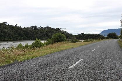
14 Esplanade Reserves Wakapuaka River (Maori Pa Road / Wakapuaka Road) Esplanade Reserve This part of the esplanade reserve is located at the fork of the Cable Bay and Maori Pa Roads. The reserve does not have formed carpark or toilet facilities. It is used for swimming and picnicking, has large native trees such as Kahikatea and Totara, and part of the reserve is in grazing lease. The reserve has no toilet facilities. Photos are attached in the following page of currently used carparking sites. The Esplanade and Foreshore Reserve Management Plan 2008 states of camping: To generally prohibit camping in all esplanade and foreshore reserves, except by permit, on a short term basis at identified sites that have appropriate water and toilet facilities (3.18), and of carparking: Prohibit vehicle use in reserves except in designated roadways or parking areas (3.28.1). Significance Score /15 While the significance score does not reach the threshold of 9, the reserve does not have toilet facilities nor a formed carpark. Carparking on the site is not planned for nor intended. 14 P a g e
15 Esplanade Reserves Marina (Port Nelson area) This is a mixed area of some esplanade reserve, road reserve and sea bed. It also has mixed ownership including LINZ. There are two distinct parts to the reserve which are referred to as: 1. Dixon Basin (Akersten Street): The main marina area providing onshore facilities which support the floating pontoons. It is an unformed piece of land where vehicles can park, including boat trailers. It is also used for boat storage, Waka Ama, BBQs, sea cadets, sea scout storage and launching. It has rubbish bins, and toilets and showers for use by the boating community which are open 24/7. A further under-utilised area known as the log storage site adjacent to the Marina, has been used as a designated site for Freedom Camping by council over the 2016/17 summer. The area is tagged for future development including marine servicing, and until the Marina Strategy is implemented, it is intended to fence the perimeter and allocate the space for boat trailer parking to support the launching ramp for motorised boats. There are soil contamination matters to consider also. 2. Old Boat Harbour (Vickerman Street): This area has carparking for Marina users and toilets open 24/7. The area has considerable congestion issues. The Esplanade and Foreshore Reserve Management Plan 2008 states of camping: To generally prohibit camping in all esplanade and foreshore reserves, except by permit, on a short term basis at identified sites that have appropriate water and toilet facilities (3.18), and of carparking: Prohibit vehicle use in reserves except in designated roadways or parking areas (3.28.1). Dixon Basin Score: /15 Old Boat Harbour Score: /15 Area Freedom camping selfcontained Freedom Camping nonself-contained Freedom Camping - tenting Dixon Basin: Old Boat Harbour: It is intended to bollard off the Dixon Basin site for Marina related activities. The Old Boat Harbour area is not suitable for any further camping vehicles as it is already under significant congestion by Marina users. Health and Safety concerns have been raised with freedom campers swimming in the Marina, which is a dangerous activity. 15 P a g e
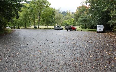
16 Esplanade Reserves Maitai River Esplanade Reserve (QEII Drive to Maitai Dam) This esplanade reserve is located in the Maitai Valley, following the River until the location of the dam. It is a key area in Nelson for picnicking, swimming and passive recreation. Historically it has been a nocamping area for this reason and much of the reserve is bollarded off from vehicle access. The reserve has a Golf Course on it with carpark and toilets, Maitai Campground, high quality plantings, a mountain bike area, and picnic facilities. There is an additional toilet block on the South end of the reserve. The only formal carparking area is at the Golf Course. There are several unformed access points available for picnicking, but it is not intended these are used for formal vehicle parking, nor to normalise these areas for that purpose. The following page attaches photos of currently used carparking areas. The Esplanade and Foreshore Reserve Management Plan 2008 states of camping: To generally prohibit camping in all esplanade and foreshore reserves, except by permit, on a short term basis at identified sites that have appropriate water and toilet facilities (3.18), and of carparking: Prohibit vehicle use in reserves except in designated roadways or parking areas (3.28.1). Significance Score /15 The area rates highly for community cultural significance as a main recreating area. Health and Safety ranked highly due to the ongoing vandalism, vehicle related problems and public nuisance at night. Many areas are located at night because of these issues, including the Dam. The Gold Course carpark is not suitable for motorhome parking due to its small size and high usage. The activity of campervan parking is not consistent with the Esplanade and Foreshore Reserves Management Plan P a g e


17 H I J K L M N O 17 P a g e

18 Esplanade Reserves Maitai River Esplanade Reserve Shakespeare Walk This esplanade reserve also follows the River located in The Woods suburb. It is a passive reserve for strolling and dog walking, and a whitebait spawning ground. The River bank is kept in long grass in part, to protect this spawning ground. There are no toilets or formed carparks on the site. Vehicles do park on the grass reserve while people are walking or exercising their dogs. The Esplanade and Foreshore Reserve Management Plan 2008 states of camping: To generally prohibit camping in all esplanade and foreshore reserves, except by permit, on a short term basis at identified sites that have appropriate water and toilet facilities (3.18), and of carparking: Prohibit vehicle use in reserves except in designated roadways or parking areas (3.28.1). Significance Score /15 Although vehicles are parking on the grass verge, this is not a formed and official area to be encouraged further. In addition the Esplanade and Foreshore Reserves Management Plan 2008 does not permit this activity. 18 P a g e
19 Esplanade Reserves Oyster Island This esplanade and recreation reserve is located 400m offshore from Monaco Peninsula. The area has very high Maori historic values. There has been extensive planting to restore the native vegetation. The Island was bought by the Oyster Island Preservation Society and gifted to council. It has toilets and a changing shed. There is no ferry access. The Esplanade and Foreshore Reserve Management Plan 2008 states of camping: To generally prohibit camping in all esplanade and foreshore reserves, except by permit, on a short term basis at identified sites that have appropriate water and toilet facilities (3.18), and of carparking: Prohibit vehicle use in reserves except permitted by individual reserve policies (3.28.1). Oyster Island has a camping policy stating, Allow short term camping provided all conditions set out in the camping general policy are met (Policy 1). Significance Score /15 No No Yes per conditions Vehicles do not have access to the Island and it is assessed to be highly significant (exceeds 9/15). Tenting is permitted in accordance with conditions including that permission is required of the council first. 19 P a g e

20 Esplanade Reserves Haulashore Island This esplanade and recreation reserve was originally a Maori reserve and transferred to the Crown. It eventually passed through ownership structures until gifted to the council by Perrine Moncrieff in Part of the Island is subject to Iwi claim. The area has very high Maori and European historic values. Maori used the site for fishing and construction of stone tools. Oyster Island has a jetty, toilets and picnic facilities. The Esplanade and Foreshore Reserve Management Plan 2008 states of camping: To generally prohibit camping in all esplanade and foreshore reserves, except by permit, on a short term basis at identified sites that have appropriate water and toilet facilities (3.18), and of carparking: Prohibit vehicle use in reserves except permitted by individual reserve policies (3.28.1). Haulashore Island has a camping policy stating, Designate as a short term camping site for organised groups (Policy 2). Significance Score /15 No No Yes per conditions Vehicles do not have access to the Island and it is assessed to be highly significant (exceeds 9/15). Tenting is permitted in accordance with conditions including that permission is required of the council first. 20 P a g e

21 Esplanade Reserves The Glen Beach Foreshore This esplanade reserve is located in The Glen and services as access to the beach. The reserve has high Iwi significance with nearby midden sites. The site does not have toilet facilities within a reasonable distance for non-self-contained vehicles, and an unformed carpark which can take around 12 vehicles. The Esplanade and Foreshore Reserve Management Plan 2008 states of camping: To generally prohibit camping in all esplanade and foreshore reserves, except by permit, on a short term basis at identified sites that have appropriate water and toilet facilities (3.18), and of carparking: Prohibit vehicle use in reserves except in designated roadways or parking areas (3.28.1). Significance Score /15 There are no close toilet facilities to support tenting or non-self-contained vehicles. The area is popular for parking and viewing the ocean and also as a starting point for walks including the Boulder Bank and the trail to Cable Bay and therefore Freedom Camping is unable to be provided for. 21 P a g e
22 Esplanade Reserves Paremata Flats Reserve Access to this reserve is off Maori Pa Road. The reserve is fully fenced and gated, being of high environmental value. The reserved was purchased for its environmental values and contains coastal regeneration forest planted by the local community, Forest and Bird and council. There is no formed carpark area. Significance Score /15 The reserve ranks highly on significance for the environmental values and for this reason vehicle access is restricted from it. Health and Safety issues were elevated as the open paddock environment is not suitable for freedom camping vehicles. Access issues reflect the site s purpose for environmental planting which is incompatible for vehicles. 22 P a g e

23 Esplanade Reserves Wakapuaka Sandflats (Boulder Bank Drive) Carparks This reserve provides access to the Wakapuaka Sewerage Plant and further along, to a surfing spot. The reserve borders a DoC reserve, being an environmentally sensitive coastal margin of boulder bank and vegetation. There is active regeneration of the area. This is also a significant site for migratory Godwits. There are two carparks for consideration of freedom camping. They are identified as the Sewerage Plant carpark, and Snapper s Carpark to the North East used by surfers. Legislative purpose Area/significance Health and Safety Access Total Sewerage Plant Carpark Score: /15 Snapper s Carpark Score: /15 Area Freedom camping selfcontained Freedom Camping nonself-contained Freedom Camping - tenting Sewerage Plant Carpark Score: Yes (2 vehicles) No No Snapper s Carpark Score: The sewerage plant carpark area is considered suitable for a small number of self-contained vehicles, given both size and amount of current usage. No non self-contained vehicles are appropriate at either site due to the lack of toilet facilities. No vehicles are recommended at the Snapper s carpark area as it is well used by surfers, has a small number of parks and large vehicles on the sensitive coastal margin is not appropriate for environmental reasons. 23 P a g e


24 Esplanade Reserves Monaco Foreshore Reserves This esplanade reserve includes the site of a former Scout Den which was closed and reformed into a picnic area. It has a picnic table on a reserve with outstanding views bordering the water s edge. There is an unformed carpark with some 2-3 vehicle spaces. Significance Score /15 The carpark space is very small and does not provide opportunity for campervans with public access. The remainder of the reserve stretches along the foreshore of the Monaco Peninsula. It includes an attractive picnic area north of the Honest Lawyer Tavern but has no off street parking. It is not suitable for campervans. 24 P a g e
25 Recreation and Sport Reserves Neale Park, Guppy Park and Miyazu Park These recreation reserves are on a former landfill site with access from State Highway 6, Atawhai Drive, North Rd, Weka St and Sovereign St. The reserves have a mix of a Japanese Garden with toilets open 24/7, a skate park, Founder s Heritage Museum, a council nursery, changing facilities, dance club and pipe band buildings, active recreation sports grounds including rugby, cricket and soccer, and an area of boggy grassland. The reserve also borders a Marae. There are two carparks permitting around 30 vehicles. Significance Score /15 Miyazu Carpark /15 Area 25 P a g e Freedom camping selfcontained Freedom Camping nonself-contained Freedom Camping - tenting Marae-end Carpark: Sovereign St Carpark: Skate Park Carpark Weka St Carpark North Rd and Carpark Founders Carpark Miyazu Carpark The carpark near the marae has some 30 carparks and there is a set of toilets and refuse facilities. During tangi or Marae community gatherings there is a shortage of parking spaces, and freedom camping cannot be provided for. The Sovereign St, Skatepark, Weka St and North Rd carparks are not suitable for freedom camping as they are required to service sport. Founders carpark provides for Founders Museum, often for evening events and is not available. The Miyazu Carpark provides for 4 cars which are required for visitors to the Miyazu Gardens. Use is high in the evenings and therefore unsuitable for freedom camping.

26 Recreation and Sport Reserves Trafalgar Park This is a recreation reserve and local purpose reserve. This is a significant reserve with high quality sandbased sportsground hosting major events of up to 10,000 spectators. Facilities on the reserve include grandstand, toilet and change facilities, netball, rugby and soccer facilities, squash club, brass band, and gym. The Reserve Management Plan for Trafalgar Park allows for self-contained vehicles for two consecutive nights but non self-contained are not provided for. Significance Score /15 Area Freedom camping selfcontained Freedom Camping nonself-contained Freedom Camping - tenting Hathaway Tce Carpark: Kinzett Tce Carpark: Yes (4 vans in the northern Kinzett Terrace area) No No This reserve scored highly for significance as it is the main outdoor events area for the City. It also has high access issues including night games and regular weekend usage. The Reserve Management Plan does not allow non self-contained. A provision for 4 vans can be made in the Kinzett Terrace area. However, in the Hathaway Terrace carpark no provision is made due to high congestion and access issues frequently in the week and weekends. 26 P a g e
27 Recreation and Sport Reserves Rutherford Park This is a local purpose and recreation reserve. Part of the reserve is significant to Maori (Nelson Tenths portion). Agreement about future use of the area with iwi is under discussion. The discussion to date centres on activities which are for park uses, which would not include freedom camping. The park contains the Trafalgar Centre indoor events centre, skate park, squash, tennis, croquet areas, an Arts Council building, Plunket and the Citizen s Advice Bureau. The Reserve Management Plan for Rutherford Park contemplates freedom camping for two consecutive nights. However, under resource consent the conditions of consent are that the number of carparks are provided for the users. Additional draw on the carpark by freedom camping is not consented. Significance Score /15 The Park is a significant recreation area in Nelson. No freedom camping is permitted on the site due to the resource consent requirements of the Trafalgar Centre, and the developing Iwi agreement. 27 P a g e
28 Recreation and Sport Reserves Andrew s Farm Reserve This sports field reserve borders the Codgers Mountain Bike Trails the main mountain bike hub. The reserve contains a riding for disabled arena, organic garden, and open space for mountain bike events. Facilities include a composting toilet for the organic garden and a carpark with some 12 spaces. There is insufficient parking for the demand caused by mountain biking and planning is underway for an expanded carpark with some 50 carparks. Significance Score /15 This is a carparking area under considerable stress from congestion which is a major issue to local people and mountain bikers alike. It is not appropriate to add to this issue with freedom camping vehicles. For this reason the Access criteria has scored highly. 28 P a g e


29 Recreation and Sport Reserves Botanics Sports field The Botanics Sports field is the site of the first rugby game in New Zealand played in This recreation reserve was vested in council in 1966 and contains notable trees. Facilities include playing fields, clubrooms, toilets open 24/7, playground, cricket nets and pitch, boardwalk and trails. It is well used in summer and winter. The reserve contains angle carparking for some 12 vehicles. Significance Score /15 The reserve is assessed as significant historically and due to its present high quality amenity values. With only 12 carpark spaces it does not provide for freedom camping. 29 P a g e
30 Recreation and Sport Reserves Maitai Cricket Ground This recreation reserve was purchased from a neighbouring landowner in the 1990s for the purpose of a sports ground to add to Branford Reserve. It is used for cricket, soccer, weekend junior sports, dog walking and some mountain biking. There are no toilet facilities and an unformed carpark with some 10 vehicle spaces. Significance Score /15 Yes (2 vehicles) No No The area would support overnighting by a small number of self-contained vehicles, but not non selfcontained due to the lack of toilet facilities. Due to the small number of carparks only two are recommended available for self-contained vehicles to be moved on before weekend sport begins. 30 P a g e

31 Recreation and Sport Reserves Pioneers Park Sports Ground This neighbourhood reserve is used as a sports ground with clubrooms, playground, youth meeting room, toilets, Nelson Athletics building, junior soccer and the meeting place for various Nelson sports groups. It is well used and located in an area of high density housing, close to the City. There is a carpark with 21 spaces around the clubroom which is used most nights. The road edge is unsuitable for carparking as a steep slope drops away. Significance Score /15 The site is not suitable for freedom camping as it has very few carparks at a well-used facility. Conflict of space is too great. 31 P a g e

32 Recreation and Sport Reserves Tahunanui Recreation Reserve This is one of Nelson s premier recreation reserves with high landscape and ecological values. The 2.6ha area was part-purchased from the Green estate in 1900 for recreational use. Six Iwi have mana whenua over the area and are clarifying ownership. It was an historic area for seafood gathering. The back beach embayment has nationally significant ecological values. Multiple sports and passive recreation users recreate in the area. Its facilities include playground and skate park equipment, Tahuna Fun Park, megaslide, commercial hospitality and community facilities, campground and multiple sporting codes using sports field throughout the year. The Tahuna Reserve Management Plan 2004 does not permit freedom camping. The Plan states (1.16.6) Camping is only permitted in the motor camp. The Tahuna campground offers a low rate of $10 (2016/17) camping on site for motorhomes. Significance Score /15 Freedom camping is not permitted under the Tahuna Reserve Management Plan P a g e
33 Recreation and Sport Reserves Ngawhatu Sports Field This is a recreation reserve with a cricket wicket and two rugby league fields. There are also changing rooms and a playground. The carpark has some 12 spaces. Significance Score /15 There are not currently carparking or toilet facilities for freedom camping. The reserve is well used by the public for sports and the carpark is required to service sport. 33 P a g e

34 Recreation and Sport Reserves Marsden Recreation Ground This recreation reserve located in Stoke is a significant hub for Stoke sports. Originally it was gifted to the City with a caveat stating, For the playing of English games. Facilities on the site include cricket and pavilion, toy library, indoor bowls Stoke Community Hall, age centre, Plunket rooms, and toilets within a building which are inaccessible to freedom camping. A carpark with some 50 parks services well used buildings. The Stoke Community Hall is one of Nelson s most utilised hall facilities and the facilities are used most nights including 21 st birthday parties, wedding functions and other events. Significance Score /15 Without toilet facilities the carpark is not suitable for non self-contained. The carpark is also not suitable for self-contained as it is a well-used area requiring the parks to service the community. 34 P a g e


35 Recreation and Sport Reserves Saxton Field Saxton Field recreation reserve is Nelson s premier sports ground hosting international games for cricket, softball and hockey. The facility is jointly owned with Tasman District Council. This top quality sports ground includes fields, stands, athletics track, indoor stadium, netball courts, hockey, softball, indoor cricket, small-bore rifle, archery, soccer fields, outdoor velodrome and playgrounds. The site has large numbers of carparks available but these are well used in the evenings and at weekends. Significance Score /15 Saxton Field exceeds the significance score as the premier sports facility in Nelson. It is a controlled site including its carparking, so freedom camping is not appropriate here. 35 P a g e
36 Recreation and Sport Reserves Greenmeadows Reserve This is a recreation reserve purchased in the 1950s for the purpose of sports grounds. It contains sports fields, clubrooms and 5 tennis courts. Currently a new Community Centre is being constructed on the site. There are no formed carparking or toilet facilities open to the general public at this time. However, when construction of the Community Centre is completed, these facilities will be provided. Significance Score /15 There are not currently carparking or toilet facilities for freedom camping. However when the Community Centre is built the appropriateness for freedom camping can be reassessed. The future availability of carparking will be guided by the resource consent conditions which stipulate how many carparks must be made available for the consented building. 36 P a g e

37 Neighbourhood Reserves Glenduan Reserve This recreation reserve with sportsground located on the boulder bank coastal margin. It borders a reserve of national significance managed by Department of Conservation. The reserve was purchased from a neighbouring farmer for a community resource. The reserve itself also has areas of cultural significance including Iwi midden sites. The reserve includes soccer fields, general sports ground, native regeneration plantings, pathway, small skate ramp, children s playground, toilet facility open 24/7 and a carpark with around 20 carparks. Significance Score /15 There are basic toilet facilities, however the car park is locked at night in agreement with nearby residents to prevent noisy behavior. The purpose of the reserve does not lend itself to a camping site. 37 P a g e

38 Neighbourhood Reserves Corder Park This is a recreation reserve with access off Atawhai Crescent for the purpose of cycling, walking and running. The reserve has a sewerage pump station, play centre, and open space. There are no toilet facilities. There is a carpark attached to the play centre but is for use of play centre parents and staff. Cars park on the roadside edge. There is also tidal encroachment into part of the reserve. The Reserve Management Plan for Corder Park highlights issues caused by vehicles on the reserve and rubbish left. Significance Score /15 This site does not have formed access and the playground carpark is not appropriate. There are no toilets. In addition the Reserve Management Plan already outlines issues of vehicles on the reserve and rubbish left behind. 38 P a g e

39 Neighbourhood Reserves Wakapuaka Reserve Wakapuaka Hall is on neighbourhood reserve land, located on SH6. It was vested in council from the former Waimea County in On the reserve is a hall, tennis courts, play centre, playground, recreation space, war memorial, toilets open 24/7, and an unformed carpark with some 40 spaces. The reserve has high daily usage for tennis and play centre. Significance Score /15 Yes (3 sites) No No The reserve rates high for Health and Safety concerns due to the conflict of vehicles and children. It is an uncontrolled site. The site is appropriate for self-contained vehicles with time restrictions on Saturday morning (vacate by 8am). Unfortunately the toilet is not adequate for non self-contained vehicle needs and nor is there adequate rubbish facilities. If the area is enhanced in future this site could be suitable for non self-contained vehicles. 39 P a g e


40 Neighbourhood Reserves Hira Reserve This reserve caters for local people enjoying the Wakapuaka River, picnics and BBQs. It has few facilities and there is one long drop toilet. There is a Reserve Management Plan over the area which highlights the roughly graded road as restricting vehicle access and the risk of polluting the River. Significance Score /15 The reserve is not suitable for motorhome vehicles and has an uncontrolled environment with the general public. The toilets are not high quality and are considered to be at capacity already. There are no rubbish facilities. 40 P a g e
41 Neighbourhood Reserves Branford Park This is a large and beautiful neighbourhood reserve with open grassed space on route to the Maitai Valley. Access is restricted by bollards. There is a large carpark on the north east end with access to the river at Dennes Hole and a toilet nearby. The area near the river at Black Hole is used by local people for a swimming hole. Parking spaces are well used. On the south west end of the reserve are two further carparks allowing some 30 vehicles and further carparks on the opposite side of Maitai Valley Road near the quarry. The reserve is a significant green space for the nearby city. Because of the popularity of the area for picnicking there has been an historic position of keeping camping out of this area. Significance Score /15 The area scored highly for significance due to its importance to the city public for recreation. Access is also scored highly as the reserve has been bollarded off to restrict vehicle access. Considering the evening use of the reserve there simply is not room for motorhome vehicles. 41 P a g e
42 Neighbourhood Reserves Waahi Taakaro Reserve This reserve up the Maitai Valley is adjacent the Maitai River and includes the swimming hole Sunday Hole. It is a picnic and recreation area for city residents. A carpark at Sunday Hole can cater for some 20 vehicles. This reflects an ongoing issue with reserves in the area of vandalism and vagrancy. Significance Score /15 The reserve ranks highly on significance as it is a premier playground for local residents. Health and Safety and Access rank highly as safety cannot be guaranteed with the vandalism and issues in the area at night. The carpark has been locked at night as a result. 42 P a g e

 No No This reserve is suitable for self-contained vehicle")
43 Neighbourhood Reserves Centennial Park Centennial Reserve in Tahunanui is a neighbourhood reserve with sports ground and passive recreation. It has no toilet facilities but does have a carpark with holds some 18 vehicles. Significance Score /15 Yes (4 vehicles) No No This reserve is suitable for self-contained vehicle parking. No non self-contained are contemplated as there are no toilet facilities. 43 P a g e
44 Neighbourhood Reserves Burrell Park This is a neighbourhood reserve close to the Centennial Reserve. It is open space with meeting rooms in the Tahuna Community Centre. The Community Centre hosts a play group and Tai chi. The Park has a small carpark for some 16 cars which is well used by the Community Centre and play group. There are toilets inside the building which are accessible when the building is in use. Significance Score /15 Burrell Park only has limited access for users and toilet facilities are only available to users of the building. 44 P a g e


45 Neighbourhood Reserves Tosswill Reserve Tosswill Reserve is a sports park hosting bowling and tennis. There is a carpark of some 30 vehicles to cater for the clubs. The carpark is well used. Toilet facilities are available to club members and open when sports are being played. The facilities are well used in daytime and evening. Significance Score /15 The reserve is well used by clubs and limited in facilities for non self-contained vehicles as well. 45 P a g e


46 Neighbourhood Reserves Monaco Reserve This is neighbourhood reserve with grassed area for community recreating in the Monaco community. There is a carpark with some 12 spaces. The reserve has a set of basic public toilets open 24/7 some 80m away from the carpark. Significance Score /15 The space is suitable for self-contained vehicles, however the parking area is currently locked at night to avoid disturbance to the adjacent neighbour. This indicates that this area is unsuitable for freedom camping. 46 P a g e
47 Neighbourhood Reserves Pipers Park This is a recreation which contains revegetating areas and mountain bike tracks. There is also a walking track route towards Tahuna Beach. The reserve does not have toilet facilities. Parking is provided at the end of Emano Street, but is minimal and unformed. Significance Score /15 Access has been assessed highly as there is no genuine access for vehicles to the area. Those using several unformed points are mountain bikers accessing the trails. 47 P a g e


48 Neighbourhood Reserves Betsy Eyre Park This neighbourhood reserve borders the Codgers Mountain Bike Trails the main mountain bike park. In recent years it has served as the carpark area for mountain bikers which has caused considerable contention with neighbouring residents. To resolve issues planning is underway for an expanded carpark with some 50 carparks further up the Brook Valley. Significance Score /15 This is a carparking area under considerable stress from congestion which is a major issue to local people and mountain bikers alike. It is not appropriate to add to this issue with freedom camping vehicles. For this reason the Access criteria has scored highly. The carparking is likely to be removed. 48 P a g e


49 Neighbourhood Reserves Betsy Eyre (North) Park This small recreation reserve was gazetted in It contains open space with mature trees. There is an unformed carpark with some 3-4 carpark spaces. The intention on the reserve is to retire it completely to native plantings. There are no toilet facilities. Significance Score /15 While there could be a case for self-contained vehicles in this carpark, there is an intention to retire the area for planting. Allowing vehicles under these circumstances would be confusing. 49 P a g e


50 Neighbourhood Reserves Cattle Market Reserve This neighbourhood park was the original site of the cattle market. Today it hosts the Centennial Bowling Club with a number of New Zealand champion bowlers having come from this club. There is club carpark with some 30 carparks, all of which are used by the Bowling Club. Significance Score /15 The carparking area scores highly for Access as the area is well used for the Bowling Club. 50 P a g e
51 Neighbourhood Reserves Enner Glynn Reserve This neighbourhood reserve is located on Enner Glynn Road. It contains a kindergarten and plantings. There are 8 carparks and no publicly accessible toilet facilities. The carparks are well used by the kindergarten and primarily for this purpose. Significance Score /15 Access scores highly as this carparking area is primarily for kindergarten use and not appropriate for freedom camping. 51 P a g e
52 The Neighbourhood Reserves Grove Reserve This neighbourhood reserve was received by council as a bequest from R.B. Jackson in the early 1900s. It contains a kindergarten, playground and toy library. There is vehicular access which serves as a drop-off point for kindergarten parents. There are no publicly accessible toilet facilities. Significance Score /15 The Access criteria scored highly as there are very few carparks and the primary purpose as a drop-off area. 52 P a g e


53 Neighbourhood Reserves Hanby Park Hanby Park is a pretty park located on Hanby Road. This is a neighbourhood park which fulfils esplanade purposes. The park is part of the Maitai Walkway / Cycleway and is adjacent to a popular swimming hole. There are no toilets on-site and no parking. Significance Score /15 This area is unsuitable for freedom camping. 53 P a g e


54 Neighbourhood Reserves Hockey Reserve Hockey Reserve is adjacent to the esplanade reserve at Brook Stream. This neighbourhood reserve has been vested in council through subdivision reserve contribution. It contains a children s playground to accommodate the subdivision families and some 4 carparks. The playground is particularly popular and attracts residents from a wider area of the City. There are no toilet facilities and the community has been asking for toilet facilities to be constructed. Significance Score /15 The Access criteria has scored highly as there are only 4 carparks for a very popular playground. Freedom camping purposes cannot be considered here. 54 P a g e
55 Neighbourhood Reserves Moncrieff Reserve This neighbourhood reserve located in the Tahuna Hills was vested in council through subdivision reserve contributions. It has an accessway and walkway with a viewing platform over Tasman Bay. There are no facilities nor formed carpark. Significance Score /15 The Significance criteria scored highly due to the reserve s popularity of stunning Tasman Bay views. However there is no formed carparking area. 55 P a g e


56 Neighbourhood Reserves Norgate Reserve This neighbourhood reserve is located close to the Annesbrook roundabout. It was vested in council through subdivision reserve contributions. The reserve contains tree plantings with three unformed carparks. Significance Score /15 The small carparking area is located on NZTA land however its use for freedom camping would restrict access to the Council Reserve. There are no toilet facilities. 56 P a g e

 No No This carparking area would be suitable for self-contained campervans overnighting who could use 4 of the existing car park spaces.")
57 Neighbourhood Reserves Paddy s Knob Reserve This neighbourhood reserve has a viewing platform and well photographed views over Tasman Bay. There is well established vegetation on the site but no toilet facilities. The formed carpark contains 3 bus parks and 5 carparks and has congestion during the day. There is discussion with neighbouring residents about the potential for a future playground on the site which would likely reduce the number of carparks. Significance Score /15 Yes (4) No No This carparking area would be suitable for self-contained campervans overnighting who could use 4 of the existing car park spaces. Congestion is more a daytime issue. There are no facilities to support non self-contained vehicles. Health and Safety rated higher due to vandalism issues on the park. 57 P a g e


58 Neighbourhood Reserves Riverside Reserve Riverside Reserve is a neighbourhood reserve at Riverside Pool. Riverside Pool is the main pool complex for Nelson City and is well used by park goers and swimmers from early morning to evening. There are some 40 carparks. Significance Score /15 The carparking area is dedicated for pool and park use and is not suitable for freedom camping. 58 P a g e


59 Neighbourhood Reserves Russell Reserve This neighbourhood reserve is located on a steep hillside. It has a playground, tree and a walking track. There are no toilets and a small carpark for 2 vehicles only. Significance Score /15 There is insufficient carparking space for freedom camping use. 59 P a g e
60 Public Garden ANZAC Memorial Park ANZAC Park is a significant cultural site in Nelson with the main RSA Memorial site, public toilets and a number of notable trees. The RSA have a significant stake in usage of the reserve. The reserve contains a public garden. The Reserve itself does not have a carpark. Significance Score /15 This site is of significant cultural value. Access issues are rated highly as no carparking is provided on the site. Freedom camping is not permitted. 60 P a g e
61 Public Garden Queen s Gardens Queen s Gardens are Nelson s premier public gardens and do not contain vehicle access. The site includes notable trees and is significant to both iwi and European history. It was an original eeling site for local Maori. The site includes toilet and refuse facilities, and walks. Significance Score /15 Queen s Gardens ranks as significant on the scoring due to its high cultural and botanic significance. Access issues are rated highly as no carparking is provided on the site. Therefore no freedom camping is appropriate. 61 P a g e


62 Public Garden Pikimai (Church Hill) This reserve contains high quality public gardens, a cathedral, and listed trees and includes an historic Maori Pa site. There is a carpark servicing the cathedral but it is under the control of the Diocesan. Significance Score /15 No freedom camping is permitted on the site due to its highly significant values. 62 P a g e


63 Public Garden Broadgreen Gardens This reserve is a public garden containing the historic Broadgreen pioneer homestead and grounds. The building dates to the 1840s. The house is now a museum with surrounding rose gardens. There is a standalone toilet block and a small carpark for some 3 vehicles. Significance Score /15 This is a significant reserve to the City and has a very small carpark not enabling other vehicles to share the space. 63 P a g e

64 Public Garden Isel Park Isel Park is a public gardens recreation reserve purchased in the 1950s. It is the site of the historic Thomas Marsden home which has heritage status. The house also has museum storage, grounds and carparking which services Isel House and reserve with some 15 carparking spaces. There is also a second carpark off Main Road Stoke which has some 30 carpark spaces. This also services the adjacent church and cemetery and Greenmeadows Recreation Reserve. Legislative purpose Area/significance Health and Safety Access Total Marsden House Carpark Score: /15 Main Rd Stoke Carpark Score: /15 Area Freedom camping selfcontained Freedom Camping nonself-contained Freedom Camping - tenting Isel House Carpark Score: Main Rd Stoke Carpark Score: Yes (3) No No The Isel House carparking area is not appropriate for freedom camping. It is a significant site with a carpark well used by locals and visitors to the historic building and museum. The Main Road Stoke carpark also serves Greenmeadows, one of Nelson s busiest sports fields. For this reason freedom camping is limited to P a g e
65 Landscape Reserves Grampians Reserve The Grampians is a 160 hectare, hilly landscape reserve that forms the greenbelt backdrop to the City. The reserve is used for walking activities. It has almost no public vehicular access and a small unformed carpark with some 6 spaces off Market Road. In the Conservation and Landscapes Reserve Management Plan 2009, significant issues for management in the reserve include the risk of wild fire and invasive pests. Regarding vehicle use and carparking (5.23) the Reserve Management Plan allows parking on designated (meaning, officially formed) roadways and parking area so long as it does not threaten habitats, water quality, heritage values or conflicts with other reserve users. Under the Reserve Management Plan camping is permitted in provided-for huts (5.17), but currently there are none in this reserve. Significance Score /15 The Grampians does not have sufficient access for motorhomes, and parking is not permitted anyway under the Plan as the small number of informal carparks are unformed. 65 P a g e
66 Conservation Reserves Marsden Valley Reserve This is a conservation reserve with significant native vegetation including Kahikatea and Totara, and part forestry. There are also indigenous bird populations. The reserve has walking tracks (including the Involution Track), mountain biking trail, and a campsite well into the interior. There are no toilet facilities near vehicle access points. There are two carparking areas which are unformed. One is located at Involution track on the Marsden Valley Road near to Glider Road and accommodates some 12 sites. The other is at the turnaround on Marsden Valley Road. This is a turnaround not a car park, but cars park there. The resereve includes a war memorial, entrance to a walking track and is a school planting and regeneration site. In the Conservation and Landscapes Reserve Management Plan 2009, significant issues for management in the reserve include the protection of vegetation and limiting of public access and to animals. Regarding vehicle use and carparking (5.23) the Reserve Management Plan allows parking on designated (meaning, officially formed) roadways and parking area so long as it does not threaten habitats, water quality, heritage values or conflicts with other reserve users. Camping is permitted in provided-for huts (5.17). Significance Score /15 No No Yes (per conditions) The carparking areas are not formed official areas, and are small. Freedom camping is not permitted under the Conservation and Landscapes Reserve Management Plan There are enough informal sites to cater for public use access only. Tenting is permitted at designated campgrounds in the interior, not accessible by road. 66 P a g e
67 Conservation Reserves Roding Water Reserve This is a local purpose reserve for the purpose of providing water to Nelson City from the headwaters of the Roding River. The reserve traverses both Nelson City and Tasman District local government boundaries. It contains archaeological sites of regional and national significance such as Champion Smelter. Many other sites are undocumented. The reserve is also a significant bird breeding area, and contains three historic copper mines from the 1800s. There are no toilet facilities in the Nelson City portion of the reserve. In the Conservation and Landscapes Reserve Management Plan 2009, significant issues for management in the reserve include the need to limit public access to protect water quality. Regarding vehicle use and carparking, Policy of the Reserve Management Plan restricts vehicle access to the area behind the caretaker s house. Camping is permitted in provided-for huts (5.17). Significance Score /15 No No Yes (per conditions) This is assessed as a significant reserve due to its ecological and historic values, and water purposes. Carparking is not permitted under the Conservation and Landscapes Reserve Management Plan 2009 apart from behind the caretaker s house, which is not appropriate for freedom camping. Tenting is permitted at the official campground in the interior, not accessible by road. 67 P a g e
68 Conservation Reserves Maitai Water Reserve This is a local purpose reserve for the purpose of providing water to Nelson City from the headwaters of the Matai River. It contains ecosystems regarded as originally rare and are nationally listed as a priority for protection. It also contains historic copper mining heritage. Vehicle access is along the Maungatapu Track which is locked at night due to vandalism and vagrancy problems. In the Conservation and Landscapes Reserve Management Plan 2009, significant issues for management in the reserve include the need to limit public from the Maungatapu Track due to damage of the track and the conflict of vehicles and other users of the reserve (p.39). Significance Score /15 This is assessed as a significant reserve due to its ecological and historic values, and water purposes. Carparking is not provided for under the Conservation and Landscapes Reserve Management Plan 2009 and vehicular access is prevented by locked gate at night due to vandalism problems. 68 P a g e
69 Carparks Wakatu Carpark This carpark is located on Achilles Avenue and offers some 170 paid carpark spaces, with no toilet facilities. The purpose of the carpark is retail parking and it is used from early morning to late in the evening. It is often full. Significance Score /15 Yes (20 vehicles) No No This carpark does not have toilet facilities. A number of 20 self-contained vehicles are recommended to be permitted in specifically posted spaces to enable ease of management of regulatory staff. 69 P a g e
, showers and laundry.")
70 Carparks Montgomery Carpark Montgomery carpark has some 274 carparks allowing a maximum stay of 3 hours. Facilities on-site include a facility with toilets (including some open 24/7), showers and laundry. Weekend usage means that the carpark has restrictions on use from 3am Saturday morning and all day Sunday. This carpark has permitted both self-contained and non self-contained freedom camping with considerable documented issues including inappropriate use of washing facilities, environmental concerns with the flow of grey water to the Maitai River, conflict over perceptions of the inner city carpark as a camping ground, and visual nuisance of unkempt non self-contained van spaces and visitors not fully clothed in public. Significance Score /15 Yes (20 vehicles) No No The carpark does support the use of non self-contained vehicles with its 24/7 toilet facilities. However the weight of issues by past non self-contained freedom campers leads to the recommendation that none be permitted on-site. A number of 20 self-contained vehicles are recommended to be permitted under time conditions (6pm to 7.30am, except on Friday and Saturday nights) as markets are held on the Square on Saturdays and Sundays and early setups are required. Specifically posted campervan spaces will be made available to enable ease of management of regulatory staff. The draft Nelson City Freedom Camping Strategic Plan 2016 considered the carpark for freedom camping and concluded that the City s camping grounds need to be supported and the development of carparks into surrogate camping grounds is not supported by the draft Strategy. Self-contained vehicles were supported for overnighting. 70 P a g e

71 Carparks Buxton Carpark Buxton carpark has some 315 paid carparks allowing a maximum stay of 3 hours. Facilities on-site include toilets open 24/7 and rubbish facilities. This carpark has permitted both self-contained and non selfcontained freedom camping in the past with some documented issues including environmental concerns with the flow of grey water to the Maitai River, opposition to its use for freedom camping by New Zealand Police, conflict over perceptions of the inner city carpark as a camping ground, and visual nuisance of unkempt non self-contained van spaces and visitors not fully clothed in public. A counter opinion was that Buxton Carpark was suitable for non self-contained vehicles as it aided surveillance on a historically troubled space at night, and added to the cosmopolitan inner-city aura. Significance Score /15 Yes (20 vehicles) No No The carpark does support the use of non self-contained vehicles with its 27/7 toilet facilities. However the weight of issues by past non self-contained freedom campers leads to the recommendation in this Assessment that none be permitted on-site. A number of 20 self-contained vehicles are recommended to be permitted in specifically posted spaces to enable ease of management of regulatory staff. The Nelson City Freedom Camping Strategic Plan 2016 considered the carpark for freedom camping and concluded that the City s camping grounds need to be supported and the development of carparks into surrogate camping grounds is not supported by the Strategy. Self-contained vehicles were supported for overnighting. Non self-contained was also supported subject to the preference of elected council in the matter. 71 P a g e
72 Carparks Miller s Acre Carpark This carpark has some 65 carparks allowing a maximum stay of 3 hours. Located adjacent to the Information Centre the carpark was opened some time ago to non self-contained vehicles to support the link to tourism information. After a spate of nuisance and rubbish incidents on the site the carpark was closed to non self-contained vehicles and remains so. There is conflict of space in this carpark. Significance Score /15 The carpark is well used at night by movie goers, as it provides nearby parking for the cinema. The carpark toilet facilities are closed at night, and with a history of civic problems caused by freedom campers, this carpark is not recommended for either category of vehicle. 72 P a g e
73 Carparks Strawbridge Square This carpark has some 160 parks serving the surrounding shopping centre of Stoke. There is shortage of space in this carpark. Significance Score /15 The carpark toilet facilities are adjacent to the library. Visibility into the site is poor, and the carpark well used. It is not recommended for either category of vehicle. 73 P a g e


74 Road Reserves Haven Road - adjacent to ANZAC Park There are some 38 carparks in the Haven Road road reserve adjacent to ANZAC Park. The parks team has identified issues in the reserve caused by non self-contained freedom campers walking through high value shrubbery to use the toilet facilities. Plants are being damaged. Significance Score /15 This site is of significant cultural value and also has issues of congestion at times. Whilst there are toilet facilities which are open 24/7, due to the historic issues with freedom campers damaging plants non self-contained freedom camping is not permitted. 74 P a g e


75 Road Reserves Riverside Riverside is a road leading to a neighbourhood reserve and the Riverside Pool, which is the main pool complex for Nelson City. The road culminates in a carpark which is well used by park goers, and swimmers from early morning to evening. There are some 40 carparks. Significance Score /15 The carparking area is used by pool and park users and is not suitable for freedom camping. 75 P a g e
76 Queen Elizabeth II (Gardens) Reserve This reserve is partially owned by NZTA and partly by the Council and located on the seaward side of QE II Drive opposite Neale Park. There is a management agreement between NZTA and Nelson City Council for the reserve s maintenance. Carparking consists of a State Highway 6 layby. Under NZTA s policy position freedom camping is permitted. There is no clause in the management agreement permitting Nelson City Council to modify this stance. Significance Score /15 Yes (sharing carparking space) No No The layby area is guided by NZTA policies which permit freedom camping. Self-contained vehicles can share the carparking space but there are no toilet facilities to recommend non self-contained vehicles. 76 P a g e

77 Other Nelson City Local Authority Areas Nelson Inner-City Streets (Inner-City Zone) The freedom camping strategic review 2016 recommends an approach of providing a warm embracing City to visitors in a way which balances economic benefits with City values and quality of environment. The inner-city has proved popular for visitors over the years. This Site Assessment has recommended that freedom camping in self-contained certified vehicles be permitted in several inner-city carparks with restrictions on hours and numbers of vehicles. At peak, Nelson City may be catering for up to 510 vehicles per night which are looking to stay 1-2 nights. The concentration of Inner-City Zone (excluding restricted carparks) vehicles in the inner-city has historically led to issues of public feedback and conflict with various options being developed to manage the effects of Freedom Camping. Sites trialled and abandoned for Freedom Camping have included Sovereign Street and Miller s Acre Carpark. The inner-city zone has been defined by council as the streets bounded by Grove Street, Halifax Street, Haven Road, Rutherford Street, Selwyn Place, Selwyn Place West and Collingwood Street. Significance Score /15 The inner-city zone rates as highly significant to the Nelson community. Considerable research has been undertaken into the issues surrounding the inner-city area and freedom camping to arrive at this recommendation. The research is outlined in the next section relating to Other Nelson Streets, and relates to both sections. Health and Safety issues for visitors has been elevated to a 3 in consideration of reported crime toward visitors in the inner-city. 77 P a g e
Nelson/Tasman Recreation Cross Boundary Partnerships. Presented by Richard Kempthorne Mayor Tasman District
 Nelson/Tasman Recreation Cross Boundary Partnerships Presented by Richard Kempthorne Mayor Tasman District Presentation in two parts Regional Communities Facilities Plan Regional Communities Facilities
Relationship of bylaw with the Ngati Tuwharetoa, Raukawa and Te Arawa River Iwi Waikato River Act
 Contents 1. Title......... 3 2. Commencement...... 3 3. Purpose......... 3 4. Interpretation...... 3 5. Camping Grounds...... 4 6. Freedom Camping...... 4 7. Offences and penalties...... 5 8. Relationship
1932 The Aero Club leased 45 acres from the Saxtons for their first terminal Cook Strait Airways started operations from the Aero Club.
 6. History Pre-European history There is no record of the area (which was very swampy) being of particular significance but the general area around Tasman Bay was used for fishing, eeling and hunting by
Frequently Asked Questions South Head Paper Roads By the South Head Action Group
 Frequently Asked Questions South Head Paper Roads By the South Head Action Group May 2010 What is the issue about? The Rodney District Council is planning to close a safe public vehicle accessway to the
Draft Marine and Harbour Facilities Strategy
 Draft Marine and Harbour Facilities Strategy Vision The Coromandel peninsula is a destination of choice for safe, sustainable and accessible marine and harbour facilities that are fit for purpose to meet
Land Management Summary
 photo credit: ANGAIR Anglesea Heath Land Management Summary The Anglesea Heath (6,501 ha) was incorporated into the Great Otway National Park in January 2018. This provides an opportunity to consider the
Council is proposing to standardise with the New Zealand Motor Caravan Association Model Bylaw Oppose
 From: Sent: To: Subject: Webmaster Thursday, 27 August 2015 2:29 p.m. General Freedom Camping Bylaw Submission Name: Graeme Egerton Organisation (if applicable): There is an opportunity to speak about
2.2 For these reasons the provision of tourist signing will only be considered:
 TOURIST SIGNING POLICY 2015 1. DEFINITION 1.1 A tourist destination is defined as a permanently established attraction which attracts or is used by visitors to an area and is open to the public without
STATEMENT OF PROPOSAL
 STATEMENT OF PROPOSAL DISTRICT FREEDOM CAMPING BYLAW 2011 1. Background 1.1 Reasons for the Proposal Sections 145 and 146(b)(vi) of the Local Government Act 2002 (LGA02) and section 12 of the Litter Act
E40. Temporary activities
 E40. Temporary activities E40.1. Background Temporary activities contribute to Auckland's vibrancy and to the social, cultural and economic well-being of communities. Temporary activities also enable filming
FAMILY CARAVAN AND CAMPING SITE RULES AND REGULATIONS
 FAMILY CARAVAN AND CAMPING SITE RULES AND REGULATIONS March 2018 March 2018 Family Caravan and Camping Site 2018 Cardiff Bay will play host to the 2018 National Eisteddfod, which will be held between 3
FREEDOM CAMPING Bylaw.
 FREEDOM CAMPING Bylaw 2017 www.napier.govt.nz Contents Napier City Freedom Camping Bylaw 2017 1. Title page 2 2. Commencement and review date page 2 3. Purpose page 2 4. Definitions page 2 5. Areas for
1.1 To promote safe and environmentally responsible overnight camping within the Ruapehu District.
 Council Policy Policy Title: Responsibility: Group Manager Community Services First Adopted: 13 March 2012 Review Frequency: Three yearly or as required Last Reviewed: February 2018 Next Review Due: February
DESCRIPTION Governance Glenmark Reserve Committee Management Glenmark Reserve Committee Location Glenmark INTRODUCTION
 CLUTHA MACKENZIE RESERVE GLENMARK RESERVE Area (hectares) 0.2645 Legal Description 216 District/ Part Lot 1 DP 12263 Block XV Adjacent Land Residential properties and Motanau Beach Parade Playground Reserve
Discover. Ashhurst Domain. Nature s Playground
 Discover Ashhurst Domain Nature s Playground Discover Step back into New Zealand, Aotearoa, of generations long gone. Discover lush natural surrounds echoing with rich birdsong in one of the Manawatu s
Park Design and Location Criteria
 Park Design and Location Criteria This section is presented in the interest of assisting park and recreation agencies in the development of a system of parks and recreation areas. A recreation system is
Wanaka Community Board 15 April Report for Agenda Item: 4
 Wanaka Community Board 15 April 2015 Department: Infrastructure Report for Agenda Item: 4 Mt Burke Station Stopping and Vesting of Road Purpose 1 To obtain the Board s support for a stakeholder agreement
Otorohanga Stopbank Pathway - Project Overview
 Otorohanga Stopbank Pathway - Project Overview Introduction Otorohanga District Council with the support of the Otorohanga Community Board are constructing a 3.5 km long gravel pathway for shared use on
SPORT AND RECREATION portfolio
 40 Annual Report 2012 SPORT AND RECREATION portfolio To maximise opportunities for Cantabrians to continue to participate in sport and recreation activities. The Trustees focus is on youth participation.
MTB Trails Trust Submission to Council s Long Term Plan
 MTB Trails Trust Registration Number CC50635 P.O. Box 78 Brightwater 7051 MTB Trails Trust Submission to Council s Long Term Plan 2015-2025 Introduction This submission is from the Mountainbike Trails
EDEN PARK REDEVELOPMENT COMPLETED STADIUM DESIGN
 1 INTRODUCTION New Zealand was awarded the Rugby World Cup 2011 hosting rights in November 2005. A condition of the winning bid was the provision of a 60,000 seat stadium for the finals. New Zealand s
b. Minimum Site Area. Recreational vehicle parks shall be located on a parcel of land not less than 3 acres in area.
 6450 RECREATIONAL VEHICLE PARK REGULATIONS 6450 TITLE AND PURPOSE. The provisions of Section 6450 through 6499, inclusive, shall be known as the Recreational Vehicle Park Regulations. The purpose of these
1 INFORMATION REQUIREMENTS
 1 INFORMATION REQUIREMENTS 1.1 BACKGROUND 2 1.2 WHAT IS THE DISTRICT PLAN 3 1.3 DISTRICT PLAN STRUCTURE 4 1.4 HOW TO USE THE DISTRICT PLAN 5 1.5 STRATEGIC FRAMEWORK 6 Whanganui District Plan (15 January
Appendix 7 Local Green Spaces - Detailed Evidence
 Appendix 7 Local Green Spaces - Detailed Evidence Neigh Bridge Country Park, Somerford Keynes General information Neigh Bridge Country Park is situated at the southern entrance to Somerford Keynes village.
Blueways: Rivers, lakes, or streams with public access for recreation that includes fishing, nature observation, and opportunities for boating.
 Parks, Open Space and Trails PRINCE WILLIAM COUNTY 2008 COMPREHENSIVE PLAN TRAILS PLAN CONTENTS The components of the trails plan are: Intent Definitions Goals, Policies, and Action Strategies Trails Map
2. Goals and Policies. The following are the adopted Parks and Trails Goals for Stillwater Township:
 D. PARKS AND TRAILS 1. Introduction Stillwater Township s population is relatively low, with most residents living on rural residences on large lots. The need for active park space has been minimal in
Old Limberlost Sports Club, Butlers Road, Handsworth Wood, Birmingham, B20 2NT
 Committee Date: 07/03/2013 Application Number: 2012/07986/PA Accepted: 29/11/2012 Application Type: Variation of Condition Target Date: 24/01/2013 Ward: Handsworth Wood Old Limberlost Sports Club, Butlers
Council - Commercial Centre. Council - Reserves (General)
") Council - Commercial Centre A shopping centre Create old town and new town feeling More commercial (zoned) land near Fresh Choice Shopping centre, activities on outskirts of town to stop blockages Commercial
Council - Commercial Centre A shopping centre Create old town and new town feeling More commercial (zoned) land near Fresh Choice Shopping centre, activities on outskirts of town to stop blockages Commercial
First proposed route Purangi Estuary to Hot Water Beach. Stella Evered Reserve. Purangi Estuary
 Great Walks Project First proposed route Purangi Estuary to Hot Water Beach PACIFIC OCEAN Cathedral Cove Hahei Hereheretaura Ngati Hei Pa site Stella Evered Reserve Proposed Carpark Lees Rd Blow Hole site
CHESTER COUNTY HEALTH DEPARTMENT 402. CONTROL OF SANITATION IN ORGANIZED CAMPS AND CAMPGROUNDS.
 CHESTER COUNTY HEALTH DEPARTMENT 402. CONTROL OF SANITATION IN ORGANIZED CAMPS AND CAMPGROUNDS. 402.1. GENERAL PROVISIONS. 402.1.1 PURPOSE. The purpose of this Section is to provide for the protection
Chapter 6. Action Program. Heart of the Lakes Area Recreation Plan
 Heart of the Lakes Area Recreation Plan 1. Design and construct the following trails (please see the following map): a. the Speedway Trail 1) primary pathway the main trail 2) secondary pathway the proposed
Park-specific management and policies Wainuiomata Recreation Area
 Park-specific management and policies Wainuiomata Recreation Area 6.8 Wainuiomata Recreation Area 6.8.1 Legal status Title held: Legislative status: Wellington Regional Council Administered under Local
Applying for Tourism Signs
 Applying for Tourism Signs Section 1, Application for Tourism Signing in Kent Introduction Kent County Council Highways and Transportation (KCC Highways) control signs on local roads (excluding Medway)
Report of the Responsible Camping Working Group
 Report of the Responsible Camping Working Group To the Minister of Tourism 31 July 2018 Executive Summary The Minister of Tourism set up the Responsible Camping Working Group in April 2018 as a partnership
Port Bruce. Interim Management Statement
 Port Bruce Interim Management Statement Port Bruce Interim Management Statement August 3, 1999 This Port Bruce Provincial Park Interim Management Statement provides direction for the custodial management
RIVERDALE CITY CITY COUNCIL AGENDA January 20, 2009 AGENDA ITEM:
 RIVERDALE CITY CITY COUNCIL AGENDA January 20, 2009 AGENDA ITEM: G3 SUBJECT: Consideration of Ordinance #728 adopting a new Chapter under Title 4, Public Health and Safety, Chapter 5b, Camping. PETITIONER:
6.46 Panepane Point. Background:
 6.46 Panepane Point Location Matakana Island Current Inventory Classification: Fee Simple Toilet ID 1252 Nil 178.1806 Ha Rural. Previous RMP Kaimai Ward RMP October 2008. Matakana Island Plan adopted 23
PIONEER PARK. City of Des Peres Parks Master Plan. SWT Design 46 INTRODUCTION
 PIONEER PARK INTRODUCTION Pioneer Park is a 7 acre neighborhood park located east of Interstate 270 and south of Manchester Road along Tallie Road. The park is situated in a residential neighborhood with
PROTECTED AREAS ZONE - POLICY
 PROTECTED AREAS ZONE - POLICY.1 Introduction The Protected Areas Zone applies to the land depicted on the Ruapehu District Plan Maps as: Amenity Policy Area. Protected Areas - Conservation. (c) Protected
Date: 11 th January, From: Plaistow & Ifold Parish Neighbourhood Plan - Steering Group. Plaistow & Ifold Parish Council
 Date: 11 th January, 2017 From: Plaistow & Ifold Parish Neighbourhood Plan - Steering Group To: Plaistow & Ifold Parish Council Re: Neighbourhood Plan Report to Parish Council Meeting 17 Jan 2017 The Steering
QLDC Council 14 December Report for Agenda Item: 13
 QLDC Council 14 December 2017 Department: Property & Infrastructure Report for Agenda Item: 13 New licence to E-Skate Limited to undertake guided electric skateboard tours along the Frankton Track Purpose
Open Meeting. To update the Board on issues arising from the previous meeting.
 Open Meeting To Raglan Community Board From Tony Whittaker General Manager Strategy & Support Date 28 August 2017 Prepared by Sharlene Jenkins PA General Manager Strategy & Support Chief Executive Approved
Pembrey Country Park Caravan & Campsite 2018 Booking Conditions
 Pembrey Country Park Caravan & Campsite 2018 Booking Conditions Bookings Information:- Pembrey Country Park Pembrey, Llanelli, Carmarthenshire SA16 0EJ. Telephone: 01554 742424. E-mail: camppembrey@carmarthenshire.gov.uk
CAMPING LOS GALLARDOS RULES & REGULATIONS
 RULES AND REGULATIONS Page 1 of 8 CAMPING LOS GALLARDOS RULES & REGULATIONS (April 2008) Revision 2.0.3. Notice: These rules & Regulations may be subject to change without notice as outlined in Point 25).
TOURISM & PUBLIC SERVICES RURAL SIGNAGE POLICY
 Policy and Procedures Subject Title: Tourism and Public Services Rural Signage Policy Corporate Policy (Approved by Council): X Policy Ref. No.: ROADS-01-07 Administrative Policy (Approved by CAO): By-Law
POLICY ON VISITOR USE AND ACTIVITIES IN PARRAMATTA PARK
 POLICY ON VISITOR USE AND ACTIVITIES IN PARRAMATTA PARK Contact Officer: Visitor Services Officer Policy Approval Date: 10 January 2017 Next Policy Review Date: 10 January 2019 Published Date: 13 January
WASHINGTON STATE PARKS AND RECREATION COMMISSION POLICY/PROCEDURE
 WASHINGTON STATE PARKS AND RECREATION COMMISSION POLICY/PROCEDURE 65-13-1 Use of Other Power-Driven Mobility Devices by Persons with Mobility Disabilities at State Park Facilities See Also: 28 CFR 35 Title
SUMMER VILLAGE OF SILVER SANDS. Municipal Development Plan
 SUMMER VILLAGE OF SILVER SANDS Municipal Development Plan Bylaw 253-2014 Adopted August 22, 2014 Summer Village of Silver Sands Municipal Development Plan Bylaw No. 253-2014 Page 2 1 INTRODUCTION 1.1 SETTING
Logo Department Name Agency Organization Organization Address Information 5700 North Sabino Canyon Road
 Logo Department Name Agency Organization Organization Address Information United States Forest Coronado National Forest 5700 North Sabino Canyon Road Department of Service Santa Catalina Ranger District
places esplanade Distinctive Destinations Healthy,Active and Event Ready Family Friendly Foreshore Evolution five
 five places 1 6 2 4 3 14 5 7 8 9 13 Foreshore & esplanade Healthy,Active and Event Ready Parkland planning for enhanced triathlon competitor and spectator experience, as well as catering for everyday exercise
The original needs analysis carried out in 2001 identified three options for acquiring or leasing land for the crèche:
 5. REDCLIFFS/SUMNER COMMUNITY CRÈCHE RELOCATION Officer responsible Author Property Manager Kevin Mara, DDI 941 6401 The purpose of this report is to update the Council on the status of this project, in
Approval of Limited Facilities Camping Interim Policy 1
 Strategic policy Approval of Limited Facilities Camping Interim Policy Corporate Plan reference: A smart economy A prosperous, high-value economy of choice for business, investment and employment - Strong
J. Recreation Plan of Conservation and Development. The Town of Hebron. Section 2. Preservation of Unique Assets. 1 P a g e
 The Town of Hebron Section 2 2014 Plan of Conservation and Development Preservation of Unique Assets J. Recreation Open spaces, parks, sports fields, and recreational programs are considered essential
RIVER ACCESS STRATEGY
 RIVER ACCESS STRATEGY The River Access Strategy is a 10-year plan the City of Edmonton is developing to inform future programming, operations and infrastructure improvements that support access to the
Damage Barton Terms & Conditions
 Damage Barton Terms & Conditions We let a pitch to you with the expectation that you will follow the usual customs of good camping and caravanning. We reserve the right to ask you to leave at any point
NEW TRACK: Purerua Peninsula - Taronui Reserve Access
 NEW TRACK: Purerua Peninsula - Taronui Reserve Access NQ01 Legal access way to Taronui Reserve from Purerua Road. At the side of Purerua Road (securing may be a problem). Department of Conservation and
Reference: 06/13/0594/F Parish: Fritton & St Olaves Officer: Mrs M Pieterman Expiry Date:
 Schedule of Planning Applications Committee Date: 21 st January 2014 Reference: 06/13/0594/F Parish: Fritton & St Olaves Officer: Mrs M Pieterman Expiry Date: 20-01-2014 Applicant: Proposal: Site: Lord
PLACE RECORD FORM CITY OF MELVILLE, WESTERN AUSTRALIA LOCAL GOVERNMENT INVENTORY PLACE REFERENCE NO.: BN06 REINSTATE + NEW LISTINGS
 CITY OF MELVILLE, WESTERN AUSTRALIA PLACE RECORD FORM LOCAL GOVERNMENT INVENTORY PLACE REFERENCE NO.: BN06 REINSTATE + NEW LISTINGS NAME: POINT WALTER RESERVE, including POINT WALTER GOLF COURSE and BLACKWALL
BOAT DOCKS AND LAUNCHES. Public Engagement Report July 2015
 BOAT DOCKS AND LAUNCHES Public Engagement Report July 2015 TABLE OF CONTENTS BACKGROUND 3 STAKEHOLDER CONSULTATION 6 PARTICIPANT PROFILE 7 RESPONSE THEMES 8 CONCLUSION 16 BACKGROUND The North Saskatchewan
Bridge School, Longmoor Campus, Coppice View Road, Sutton Coldfield, Birmingham, B73 6UE
 Committee Date: 22/01/2015 Application Number: 2014/05949/PA Accepted: 08/12/2014 Application Type: Full Planning Target Date: 02/02/2015 Ward: Sutton Vesey Bridge School, Longmoor Campus, Coppice View
Recreation Management Plan Lake Baroon and Ewen Maddock Dam
 Lake Baroon and Ewen Maddock Dam December 2013 Contents Overview... 3 The Value of Our Natural Areas... 4 Management Approach... 6 Funding... 7 Recreation Management... 8 Conditions of Access and Use...
Motorhome/campervan Permit Terms and Conditions
 Motorhome/campervan Permit Terms and Conditions These conditions apply to the permit holder and any person(s) accompanying them. Any breach of these permit conditions is a contravention of byelaw 11 of
Lake Myra County Park. Wake County, North Carolina Community Forum #2 June 12, 2008
 Lake Myra County Park Wake County, North Carolina Community Forum #2 June 12, 2008 Welcome and Introduction Meeting Agenda Welcome Introductions of Project Team Master Plan Process Community Forum #1 Updates
TOWN OF WARWICK LOCAL LAW NO. 4 OF 2015 A LOCAL LAW TO AMEND THE ZONING LAW
 Local Law Filing NEW YORK STATE DEPARTMENT OF STATE 162 WASHINGTON AVENUE ALBANY, NY 12231 (Use this form to file a local law with the Secretary of State.) Text of law should be given as amended. Do not
CITY OF NAPIER DISTRICT PLAN Recognising the significant role signs have in directing, informing and advertising within the City.
 Chapter 58 SIGNS 58.1 RESOURCE MANAGEMENT ISSUES The following Resource Management Issues have been identified as significant for the City: 58.1.1 Recognising the significant role signs have in directing,
Te Kowhai COMMUNITY PLAN
 1 2011-2021 Te Kowhai COMMUNITY PLAN Vision To realise a lifestyle potential 2 Map of Te Kowhai area 3 4 History of the plan In 2004 the Te Kowhai Community Group Committee and the residents put together
ORDINANCE NO. JACKSON TOWNSHIP, CAMBRIA COUNTY
 ORDINANCE NO. JACKSON TOWNSHIP, CAMBRIA COUNTY AN ORDINANCE OF THE TOWNSHIP OF JACKSON AMENDING SECTIONS OF THE JACKSON TOWNSHIP ZONING ORDINANCE AS FOLLOWS: PROVIDING NEW DEFINITIONS OF CAMPGROUNDS, CAMPSITE,
Trail Etiquette. Hours of Operation. Trail Accessibility
 Trail Guide The Elmhurst Park District, with 28 parks and over 460 acres of land, offers nearly six miles of paved or asphalt park trails and maintains an additional 3.6 miles of trails within Elmhurst.
Flow Stand Up Paddle Board Parkway Plan Analysis
 Regional Parks Department Jeffrey R. Leatherman, Director County of Sacramento Divisions Administration Golf Leisure Services Maintenance Rangers Therapeutic Recreation Services Flow Stand Up Paddle Board
COFFS HARBOUR OPEN SPACE
 COFFS HARBOUR OPEN SPACE Developer Contributions Plan 2016 TABLE OF CONTENTS PART 1 SUMMARY SCHEDULES Executive Summary... 1 Date of Commencement of the Plan... 1 Summary of Works Schedule... 2 Summary
Watchorn Provincial Park. Management Plan
 Watchorn Provincial Park Management Plan 2 Watchorn Provincial Park Table of Contents 1. Introduction... 3 2. Park History... 3 3. Park Attributes... 3 3.1 Natural... 4 3.2 Recreational... 4 3.3 Additional
Binley Woods Parish Plan - Analysis of Main Survey Responses Section D1 Sports Activities & Play Equipment
 Binley Woods Parish Plan - Analysis of Main Survey Responses Section D1 Sports Activities & Play Equipment Question D1: How often do you use the following? Binley Woods Parish Plan Main Questionnaire 1
Hawke s Bay Regional Parks Network. Pekapeka Regional Park Individual Park Plan
 Hawke s Bay Regional Parks Network Pekapeka Regional Park Individual Park Plan 2015-2024 Hawke s Bay Regional Council 159 Dalton Street Private Bag 6006 Napier 4110 Hawke s Bay New Zealand Telephone: 0800
BOWLING BASIN WEST DUMBARTON
 BOWLING BASIN WEST DUMBARTON WELCOME Living on Water offers a vibrant and exciting way of life that opens up a whole host of opportunities. At Bowling Basin in Glasgow, Living on the Water s pretty residential
Silver Lake Park An Environmental Jewel for the Citizens of Prince William County
 Silver Lake Park An Environmental Jewel for the Citizens of Prince William County The Prince William Park Authority Mission Statement states: The Prince William County Park Authority will create quality
Freedom Camping Policy
 Freedom Camping Policy Adopted Council 17 December 2010 See following page for policy. 2010 Page1 - Page2 f camping - priv follow. areas waur enjoy. Page3 residents.. beaches, rubbish hot-spots. campers
Request for Expressions of Interest To Lease a Portion of Building located at 675 Marina Way, Penticton, BC
 Request for Expressions of Interest To Lease a Portion of Building located at 675 Marina Way, Penticton, BC Issued: October 4, 2012 The City of Penticton is seeking Expressions of Interest to sublease
Dookie and District Action Plan
 Dookie and District Action Plan 2017-18 Goal Actions Partnerships Timeframe Status Strategic Goals (i.e Council pillar) Rail Trail Continue to seek funding options for Stage 2 of the Rail Trail (to Cosgrove)
Freedom Camping Bylaw 2017
 Freedo Caping Bylaw 2017 Contents 1. TITLE... 2 2. COMMENCEMENT... 2 3. PURPOSE... 2 4. DEFINITIONS... 2 5. LOCAL AUTHORITY AREAS WHERE FREEDOM CAMPING IS PERMITTED... 3 6. PROHIBITED AREAS... 4 7. RESTRICTED
At a meeting of the Development Management Committee held on 22 February 2018
 1 HAVANT BOROUGH COUNCIL At a meeting of the held on Present Councillor Keast (Chairman) Councillors Buckley, Hughes, Keast, Perry, Satchwell, Lloyd and Guest (Standing Deputy) 105 Apologies for Absence
F6. Coastal Ferry Terminal Zone
 F6. Coastal Ferry Terminal Zone F6.1. Zone description The purpose of the Coastal Ferry Terminal Zone is to provide for the integrated and efficient operation and development of ferry terminal facilities.
Campsite Information 2018
 Campsite Information 2018 Main Road, Grendon, Northants, NN7 1JW 01933 665303 www.grendonlakes.co.uk info@grendonlakes.co.uk W E L C O M E Our campsite provides a beautiful part of Central Northamptonshire
About this consultation
 About this consultation With under 18 months to go until the XX Commonwealth Games in Glasgow, the role of each of the Games Venues is coming sharply into focus. Glasgow 2014 Ltd. will be progressing planning
PUBLIC CONSULTATION - THE PURPOSE
 PUBLIC CONSULTATION - THE PURPOSE ² To review the sites identified for housing development; ² To introduce new sites that have come forward since the last Public Consultation with potential for housing
General Rules for Use of Lands Managed by the. Middle Peninsula Chesapeake Bay Public Access Authority
 General Rules for Use of Lands Managed by the Middle Peninsula Chesapeake Bay Public Access Authority As a visitor to lands managed by the Middle Peninsula Chesapeake Bay Public Access Authority (PAA),
Gliding Society TOURING CARAVAN PARK RULES
 Gliding Society TOURING CARAVAN PARK RULES Revision 3 1. PURPOSE The purpose of the Touring Caravan Park is to support the flying activities at Lasham by providing land for parking touring caravans to
Ewen Maddock Dam RECREATION GUIDE
 Ewen Maddock Dam RECREATION GUIDE seqwater.com.au About Ewen Maddock Dam OUR VISION To manage access to recreation opportunities while protecting natural resources and water quality. Ewen Maddock Dam,
Risk Assessment. This risk assessment is fully reviewed on and annual basis. Amendments and additions are incorporated as required.
 KICC is a camping and activity centre located in Kingsdown, Nr Deal, Kent. Set in 40 acres of sloping open grassland the estate enjoys woodland boundaries and unparalleled sea views across the English
A summary of Draft Makara Peak Mountain Bike Park Master Plan
 A summary of Draft Makara Peak Mountain Bike Park Master Plan OVEMBER 216 Image: Peter Marshall 2 3 Introduction Since it was established in 1998, the Makara Peak Mountain Bike Park (Makara Peak) has grown
MASTER PLAN EXECUTIVE SUMMARY
 Biscuit Run State Park Scottsville Road (State Route 20) Charlottesville, VA 22902 Biscuit Run State Park MASTER PLAN EXECUTIVE SUMMARY Department of Conservation and Recreation Division of Planning and
NAVAJO COMMUNITY PLAN
 NAVAJO COMMUNITY PLAN Prepared by the NAVAJO COMMUNITY PLANNERS and THE CITY OF SAN DIEGO City of San Diego Planning Department 202 C Street, MS 4A San Diego, CA 92101 Printed on recycled paper. This information,
SEASONAL CAMPGROUND ADMISSION AGREEMENT
 1SEASONAL CAMPER AGREEMENT FOR 2012 (Final) 2 1 SEASONAL CAMPGROUND ADMISSION AGREEMENT 2 3 THIS AGREEMENT IS BETWEEN THE CAMPGROUND,, AND 4THE FOLLOWING PERSONS: 5ADULTS:. 6MINORS:. 7ONLY THE PERSONS
FILE: /PERM EFFECTIVE DATE: May 16, 2014 AMENDMENT:
 APPROVED AMENDMENTS: Effective Date Briefing Note /Approval Summary of Changes: FILE: 11000-00/PERM EFFECTIVE DATE: May 16, 2014 AMENDMENT: Table of Contents 1. POLICY APPLICATION... 1 2. PRINCIPLES AND
FEASIBILITY CRITERIA
 This chapter describes the methodology and criteria used to evaluate the feasibility of developing trails throughout the study areas. Land availability, habitat sensitivity, roadway crossings and on-street
A GUIDE TO MANITOBA PROTECTED AREAS & LANDS PROTECTION
 A GUIDE TO MANITOBA PROTECTED AREAS & LANDS PROTECTION Manitoba Wildands December 2008 Discussions about the establishment of protected lands need to be clear about the definition of protection. We will
Cooloolabin Dam Recreation Management Discussion Paper. November 2013
 Cooloolabin Dam Recreation Management Discussion Paper November 2013 Contents November 2013... 1 Background... 3 Overview of Cooloolabin Dam... 6 Weed Management... 7 Cultural Heritage... 7 Commercial
LYNDHURST NEW URBAN DEVELOPMENT AREA STRUCTURE PLAN. Lyndhurst New Urban Development Area Structure Plan OUTCOMES AND PERFORMANCE STANDARDS
 APPENDIX 15.1-3 LYNDHURST NEW URBAN DEVELOPMENT AREA STRUCTURE PLAN Purpose of the Structure Plan Lyndhurst New Urban Development Area Structure Plan OUTCOMES AND PERFORMANCE STANDARDS LSP-P1 The District
Community Sports Hub
 The Adelaide City Council invites engagement from the community about Project Summary Council is seeking your feedback on a draft agreement to enable the South Australian Cricket Association (SACA) to
ANAGEMENT. LAN November, 1996
 M ANAGEMENT P LAN November, 1996 for Paul Lake Provincial Park Ministry of Environment, Lands and Parks BC Parks Department Paul Lake Provincial Park M ANAGEMENT P LAN Prepared by BC Parks Kamloops Area
PARK PAVILION RULES AND REGULATIONS
 1 HARRY S. TRUMAN PARKWAY ANNAPOLIS, MARYLAND 21401 410-222-7300 PARK PAVILION RULES AND REGULATIONS Reservation Permit Is Issued Subject To The Following: 1. This permit is for a maximum of 100 persons