TEN MILE PLANNING COMMISSION AGENDA April 14, :30 p.m. Buffalo Mountain Room, County Commons 0037 Peak One Dr., SCR 1005, Frisco, CO
|
|
|
- Percival Armstrong
- 6 years ago
- Views:
Transcription

1 PLANNING DEPARTMENT Peak One Dr. PO Box Frisco, CO TEN MILE PLANNING COMMISSION AGENDA April 14, :30 p.m. Buffalo Mountain Room, County Commons 0037 Peak One Dr., SCR 1005, Frisco, CO Commission Dinner: 5:00pm I. CALL TO ORDER II. ROLL CALL III. APPROVAL OF SUMMARY OF MOTIONS: March 10, 2016 IV. APPROVAL OF AGENDA: Additions, Deletions, Change of Order V. CONSENT AGENDA: VI. PUBLIC HEARINGS: PLN Temporary Use Permit for Camping at Chapel Lot A Temporary Use Permit for tent and RV camping at Chapel Lot (Parcel 18 of the Copper Mountain PUD) to accommodate Ride the Rockies from June 13th through June 15th, 2016; Lots A, B, 2, and 3, Block 1, Copper Mountain Subdivision #2, four parcels consisting of approximately 3.8 acres; zoned Copper Mountain PUD. VII. VIII. IX. WORK SESSION ITEMS DISCUSSION ITEMS: Lake Hill Master Plan Election of Officers Suggested Revisions for Consideration in Next Master Plan Update Countywide Planning Commission issues Follow-up of previous BOCC meeting Planning Commission Issues ADJOURNMENT
2 TEN MILE PLANNING COMMISSION SUMMARY OF MOTIONS March 10, 2016 COMMISSION MEMBERS PRESENT: Mark Sabatini, Deborah Shaner, Lina Lesmes, Michael Grady, and Donna Skupien STAFF PRESENT: Keely Ambrose, Assistant County Attorney, Lindsay Hirsh, Planning Manager, Sid Rivers, Planner II, Alan Hanson, Senior Planner, Jim Curnutte, Community Development Director Mark Sabatini, Temporary Chairman, called the meeting of the Ten Mile Planning Commission to order at 5:35 p.m. Approval of Summary of Motions: The Summary of Motions of January 14, 2016 was approved as presented. REGULAR AGENDA PUBLIC HEARINGS: 1. PLN Copper Mountain PUD, Major Sign Program Comprehensive amendment to the Copper Mountain Sign Program regulating all signage within Copper Mountain, zoned Copper Mountain PUD; Sections 25, 29, and 30, T. 6 S., R.78 W. of the 6 th P.M. Motion: Commissioner Lesmes moved to approve PLN as proposed with the modified findings listed below, the removal of the condition listed in the staff report, and the provision that temporary event signs can be displayed 14 days prior to an event and three days after. FINDINGS 1. The proposed sign program is consistent with the County s Zoning Regulations, and other applicable regulations of the Code and the Copper Mountain PUD. The proposed sign program would prohibit the interior illumination of signs within the PUD. 2. The proposed sign program insures the use of sign styles and materials that are consistent and coordinated within all areas of the Copper Mountain PUD. 3. The proposed sign program specifies the number of signs, method of illumination, and location of signs that would be allowed within the Copper Mountain PUD. 4. The proposed sign program conforms to the basic sign requirements contained in Section 9100 et seq. of the Code. 5. The proposed sign program will prevent visual clutter and the disruption of important scenic corridors or vistas. The view shed within the Interstate 70, Highway 91 corridor will not be compromised. 6. The proposed sign program facilitates communication in a manner compatible with the surrounding environment as it proposes improved wayfinding signage in pedestrian and vehicular areas throughout the Copper Mountain PUD. 7. The proposed sign program protects the safety of motorists and pedestrians in a manner compatible with the surrounding environment. The Sign Program as proposed improves wayfinding for both vehicle users and pedestrians. 8. The proposed sign program is compatible with surrounding land uses and the neighborhood and will not create a substantial adverse impact on adjacent properties or infrastructure. The Sign Program was specifically designed for all neighborhoods and areas within the Copper Mountain PUD. 9. The proposed sign program is in general conformance with the applicable goals, policies/actions and provisions of the Countywide Comprehensive Plan, the Ten Mile Master Plan, and the Copper Mountain Subbasin Plan. Commissioner Grady seconded the motion and the motion passed on a unanimous vote of 4-0. Commissioner Skupien abstained as she did not attend the January meeting when this item was first discussed.
3 2. PLN15-107/108 Copper Point Townhomes Site Plan and Preliminary Plat Preliminary plat to subdivide acre Lot 2, Copper Mountain East Neighborhood Subdivision into Lot 2A, a acre parcel for the Copper Point Townhomes project and Lot 2B, a acre remainder parcel that accommodates the Alpine Parking Lot and part of the Copper Mountain Golf Course; as well as a site plan for 15 workforce townhomes on the proposed acre Lot 2A, East Lake Development Parcel (Parcel 29), Copper Mountain East Village, Copper Mountain Resort Motion: Commissioner Grady moved to approve PLN15-107, a site plan for 15 workforce townhomes on the proposed acre Lot 2A, East Lake Development Parcel (Parcel 29), Copper Mountain East Village, Copper Mountain Resort with the following findings and subject to the following conditions: FINDINGS 1. The application complies with all applicable County Zoning Regulations, including but not limited to the use, density limitations, and development standards of the Copper Mountain PUD addressing setbacks, building height, workforce housing requirements, wetland buffers, access, parking, snowstorage, and site coverage. 2. With compliance with the condition of approval noted below, the application complies with applicable County Road & Bridge standards regarding driveway access onto Copper Road. 3. The application complies with County Subdivision Regulations regarding the avoidance of development constraints, provision of adequate water, sewer, and fire protection, and avoidance of sensitive wildlife habitat such as East Lake and its associated wetland complex. 4. There are no previous approved plans or conditions of approval for the site still in effect. CONDITIONS 1. Prior to issuance of any permits by the County, the applicant shall provide a sign and circulation plan for review and approval by the Engineering and Road & Bridge Departments that mitigates atypical and potentially unsafe traffic conflicts between vehicles entering and existing the project and busses using the Shark Lane to the maximum extent feasible. 2. Prior to the issuance of any permits the applicant shall prepare a traffic safety plan, including use of the Alpine Lot s southern entrance for construction vehicle access to the site instead of using Copper Road to address safety issues for cyclists and pedestrians when driveway improvements to the Shark Lane and Copper Road are constructed. Commissioner Shaner seconded and the motion passed on a unanimous vote of 5-0 Motion: Commissioner Grady moved to recommend that the BOCC approve PLN15-108, a preliminary plat to subdivide acre Lot 2, Copper Mountain East Neighborhood Subdivision into Lot 2A, a acre parcel for the Copper Point Townhomes project and Lot 2B, a acre remainder parcel that accommodates the Alpine Parking Lot and part of the Copper Mountain Golf Course with the following findings: FINDINGS 1. The proposed subdivision of Lot 2, Copper Mountain East Neighborhood into Lot 2A (1.665 acres) and Lot 2B ( acres) will facilitate construction of 15 workforce townhomes as required pursuant to 2.7 et seq. of the Copper Mountain PUD. The proposed workforce housing project meets all other applicable requirements of the Copper Mountain PUD and the County s Zoning Ordinance. 2. The proposed preliminary plat is consistent with the County s subdivision regulations as water and sewer service will be provided by the Copper Mountain Consolidated Metro District, access will be provided from Copper Road in compliance with County Road & Bridge standards, fire protection will be provided by the Copper Mountain Fire Department, and all necessary utilities and associated easements are in place to serve the proposed Copper Point Townhome development. The project would avoid sensitive wildlife habitat
4 such as East Lake, its associated wetlands, and result in enhancement of the wetland buffer. There are no development constraints onsite such as steep slopes, geological hazards, or overly problematic soil conditions. 3. The proposed preliminary plat is in conformance with the applicable goals, policies and actions of the Countywide Comp Plan regarding; providing affordable and workforce housing, focusing new development within existing urban areas, protecting sensitive wildlife habitat such as East Lake and its associated wetland complex, supporting more transit oriented development, avoiding impacts to visually important natural features and public views, and protection of cultural resources such as the two historic cabins on the property that will be relocated and preserved as part of the overall development project. The project conforms to applicable goals, policies, and actions of the Ten Mile Basin Master Plan including; increasing the supply of affordable and workforce housing in the Basin, protecting the mountain character of the Basin by focusing new development within the Copper Mountain urban area, and protecting sensitive habitat areas by creating an enhanced wetland buffer around the East Lake wetlands complex. The proposed preliminary plat conforms to the goals, policies, and actions of the Copper Mountain Subbasin Plan because it will facilitate the provision of workforce housing at the resort that is well designed and in compliance with all applicable design standards (e.g. setbacks, height limits, architectural design character of the Copper Mountain PUD). 4. The Copper Mountain Consolidated Metro District has indicated that they have adequate water and sewer capacity to supply the proposed 15-unit Copper Point Townhome project. 5. There are no problematic soil or geological conditions that cannot be feasible addressed through proper engineered designs. There are no steep slopes or geological hazards onsite. 6. Access to the State highway and Summit County road systems will be provided via a private driveway off Copper Road. Commissioner Lesmes seconded the motion and the motion passed on a unanimous vote of 5-0 DISCUSSION The Planning Manager Lindsay Hirsh presented an update on the County s progress on planning for the Lake Hill property. ADJOURNMENT The meeting was adjourned at 8:12 PM. Respectfully submitted, Sid Rivers, Planner II Alan Hanson, Senior Planner

5 PLANNING DEPARTMENT Peak One Dr. PO Box Frisco, CO STAFF REPORT TO: Ten Mile Planning Commission FROM: Jessica Potter, Planner I FOR: Meeting of April 14, 2016 SUBJECT: Planning Case PLN16-010: Ride the Rockies TUP for Tent & RV Camping at Chapel Lot APPLICANT: Zach Ostrander OWNER: Powdr - Copper Participation, LLC REQUEST: A Temporary Use Permit for tent and RV camping at Chapel Lot (Parcel 18 of the Copper Mountain PUD) to accommodate Ride the Rockies from June 13th through June 15th, 2016; Lots A, B, 2, and 3, Block 1, Copper Mountain Subdivision #2, four parcels consisting of approximately 3.8 acres; zoned Copper Mountain PUD PROJECT DESCRIPTION Location: Chapel Lot; 670 Copper RD (CR 1190) Legal Description: Lots A, B, 2, and 3, Block 1, Copper Mountain Subdivision #2 Existing Zoning: Copper Mountain PUD Proposed Use: Participant tent and RV camping for Ride the Rockies from June 13 15, 2016 Other Uses: N/A Total site area: 3.8 Acres Adjacent land uses: East: Lots 1A (Open Space), 1B (Copper Chapel), 1C (Open Space) Copper Mountain Subdivision Filing #2 West: Snowbridge Square Condos, Block 1, Copper Mountain Sub. #2 (West Ten Mile Creek) North: Copper Road South: Copper Mountain Sub. #2 (West Ten Mile Creek) BACKGROUND Ride the Rockies is a road cycling event occurring annually in Colorado in the summertime. The 2016 ride is scheduled to begin on June 12 th in Carbondale and end on June 17 th in Ft. Collins taking road cyclists on a tour of Colorado. The event is organized by the Denver Post Community Foundation, a registered 501(c)3 tax-exempt charitable organization. The event s approximately 2,000 participants either camp at designated sites or stay in hotel/rental accommodations in the evenings during the ride. Ride the Rockies will be at Copper Mountain from June 13 th June 15 th, and participants will stay in accommodations at or near Copper Mountain as well as camp at various approved locations throughout the PUD. On June 23, 2015 the Board of County Commissioners approved PLN15-024, a PUD amendment to allow camping associated with charity events (such as the Courage Classic, most notably) on the lawn between the bike path and The Edge (Development Parcel 10), on the lawn around the Copper Chapel (Private Open Space Parcel K/Development Parcel 19), and RV/tent camping in the Alpine Lot (Development Parcel 30) (Attachment C). Ride the Rockies proposes to utilize these locations for
6 camping, but also requests to utilize the Chapel Lot for camping. Since the Chapel Lot is not one of the already-approved charity event camping locations, this application is for a Temporary Use Permit (TUP) to allow tent and RV camping at Chapel Lot from June 13 th to June 15 th, Ride the Rockies will count as one of the three camping-associated charity events permitted by the PUD. Currently, Courage Classic is the other charity event associated with camping that has been scheduled thus far for the 2016 calendar year. CRITERIA FOR DECISION The criteria of Decision for a TUP is found in Section of the Code A. The proposed use meets the definition of temporary or seasonal. B. The use is in harmony and compatible with surrounding land uses and the neighborhood and will not create a substantial adverse impact on adjacent properties or on services and infrastructure. C. The location of the proposed use is appropriate and rezoning to allow the use on a permanent basis is not advisable. D. The proposed temporary use is in compliance with the County s Zoning Regulations. E. The use complies with any specific criteria stated in this Code for the use. F. Adequate services and infrastructure are available to serve the use or the applicant has obligated himself to provide services and infrastructure in sufficient time to serve the proposed use. G. The proposal is in general conformance with the goals, policies/actions and provisions of the Summit County Countywide Comprehensive Plan and any applicable basin or subbasin master plans. DISCUSSION / ISSUES Criterion A: The proposed use meets the definition of temporary or seasonal The Summit County Land Use and Development Code defines temporary or seasonal uses as uses that: 1. Do not require any new permanent structures or improvements for their operation. 2. May use existing buildings or improvements. 3. Are active only on a seasonal or short-term basis. 4. Do not result in any negative long-term impact on surrounding properties. 5. Are situated to minimize the negative short-term impact on surrounding properties. 6. Do not exceed the following time limits (except for uses listed in Section ): a. A maximum of six (6) months annually for seasonal uses. b. A maximum of one (1) year if the use will exceed six (6) months annually for temporary uses. The request for camping at the Chapel Lot meets the above definition for temporary or seasonal. The request is for a specific time period the three days and two nights between June 13 th and June 15 th, there will be no new permanent structures or improvements, and the campers may utilize existing facilities. The short term negative impacts will be mitigated as discussed in this report and there will be no long term negative impacts. Criterion B: The use is in harmony and compatible with surrounding land uses and the neighborhood and will not create a substantial adverse impact on adjacent properties or on services and infrastructure. The request for camping at Chapel Lot will be in harmony with the surrounding land uses and neighborhoods. For the three days and two nights that Ride the Rockies will be at Copper, there will be approximately 3,000 additional individuals at the resort. Ride the Rockies will have a significant presence TMPC: PLN16-010
7 at Copper, creating a festival-like environment. Situating some of the campers at Chapel Lot, near to Center Village, which serves as a hub for the event, will be in harmony with the temporary atmosphere created for these three days (Attachments D E). Furthermore, there is already approved tent camping at the Chapel Lawn, directly to the east of the site. There is no residential or commercial use to the north, and West Ten Mile Creek provides a buffer to the campers from the commercial and residential uses to the south and south west of Chapel Lot. The campers at Chapel Lot will be adjacent to the residential uses to the northwest; however, the layout of the spaces calls for an approximately 100 buffer between the campers and Snowbridge Square, a mixed-use condominium building. Additionally, Copper will distribute a handout to campers with shower information, RV dumping procedures, and rules for camping, such as a prohibition on campfires and setback distances for tents from West Tenmile Creek, among other items. Copper has submitted the handout used for the Courage Classic as an example, and has verified that the same information will be disseminated to campers with Ride the Rockies (Attachment F). Ride the Rockies has contracted with a professional management company to coordinate and orchestrate the logistics of hauling the camp gear from site to site along the route. In accordance with the comments received from the Copper Mountain Fire District, the layout of campsites shall include adequate access for emergency fire vehicles and EMS response in case of emergency, the Fire District has reviewed the proposed layout of the campsites and has no concerns. Criterion C: The location of the proposed use is appropriate and rezoning to allow the use on a permanent basis is not advisable. As discussed, the Copper Mountain PUD was modified in 2015 to allow camping associated with charity events in designated sites as a permitted use. The Chapel Lot was not part of this request. The usual scale of events at Copper, such as the Courage Classic can be accommodated by these designated sites approved in For comparison, the Chapel Lawn can accommodate campsites whereas the Chapel Lot can accommodate 360 campsites. The scale of Ride the Rockies is considerably greater than the typical events where campers are accommodated in the summer months. Rezoning the PUD to add Chapel Lot to the list of designated sites for camping is unnecessary because the normal scale of events where camping is requested can be accommodated by the current zoning. This discussion notwithstanding regarding the applicability of this request as a TUP, it shall be noted in this report that should the applicant request camping of this scale on a repeated basis, they will be required to apply for a zoning amendment as opposed to a TUP. Criterion D: The proposed temporary use is in compliance with the County s Zoning Regulations. A 25-foot stream/riparian setback will be enforced along West Tenmile Creek. All temporary lighting for the event will comply with County zoning regulations fully-shielded and down-lit. There are no additional zoning requirements for this type of use. Criterion E: The use complies with any specific criteria stated in this Code for the use. Other than the requirements to maintain the standard stream/riparian setbacks and adhere to the County s lighting and sanitation regulations, there are no specific criteria in the Code applicable to short-term camping. Criterion F: Adequate services and infrastructure are available to serve the use or the applicant has obligated himself to provide services and infrastructure in sufficient time to serve the proposed use. TMPC: PLN16-010
8 Adequate services and infrastructure will be provided for campers at Chapel Lot. Chapel Lot may accommodate up to 360 campsites. Copper has confirmed that if additional requests for camping or lodging are made in excess of that which can be accommodated by the resort, those participants will need to find lodging elsewhere. Overnight security will be provided at Chapel Lot from 6pm to 6am. The applicant has submitted a plan for providing potable water, showers, trash/recycling, portable toilets, and gray water removal. They have contracted with McDonald Farms, a water-hauler licensed by the Colorado Department of Public Health and Environment, to provide potable drinking water and the removal of gray water from the site. County Environmental Health has met with the applicant and reviewed their plans for the provision of potable water and the removal of gray water and has no concerns. County Environmental Health has provided the applicant with information regarding the required number of portable toilets and has submitted comments requiring that all toilets are maintained in a sanitary condition that prevents the potential for disease or nuisance conditions. Additionally, the portable toilets must maintain a 50-foot setback from the top of bank of West Tenmile Creek. Showers will be available via shower trucks stationed in the Chapel Lot and overflow showers may be accommodated in the nearby Athletic Center. Criterion G: The proposal is in general conformance with the goals, policies/actions and provisions of the Summit County Countywide Comprehensive Plan and any applicable basin or subbasin master plans. The camping covered under the requested TUP is consistent with the Goals and Actions/Policies of the Countywide Comp Plan, Ten Mile Basin Master Plan, and Copper Mountain Subbasin Plan involving protection of water quality and environmentally sensitive areas due to the fact that all camping would have to maintain a minimum 25-foot setback from the top-of-bank of West Ten Mile Creek and all portable toilets would maintain a minimum 50-foot setback from the creek s top-of-bank. Additionally, the use is in line with Goal V of the Ten Mile Master plan which is to Provide for a wide range of recreational activities with the Copper Mountain Subbasin since this use and event promotes camping and cycling in the area. STAFF RECOMMENDATION Staff recommends that the Ten Mile Planning Commission approve the requested TUP with the findings and conditions set forth in the attached draft resolution. ATTACHMENTS Attachment A: Resolution Attachment B: Vicinity Map Attachment C: Approved Camping Locations via PLN Attachment D: Site Plan of Camping Chapel Lot Attachment E: Plans for Ride the Rockies at Copper Attachment F: Example of Rules for Campers cc: Zach Ostrander, Copper Mountain TMPC: PLN16-010
9 RESOLUTION NO TEN MILE PLANNING COMMISSION OF THE COUNTY OF SUMMIT STATE OF COLORADO A RESOLUTION APPROVING PLN16-010, a Temporary Use Permit for tent and RV camping at Chapel Lot (Parcel 18 of the Copper Mountain PUD) to accommodate Ride the Rockies from June 13th through June 15th, 2016; Lots A, B, 2, and 3, Block 1, Copper Mountain Subdivision #2, four parcels consisting of approximately 3.8 acres; zoned Copper Mountain PUD; (Applicant Zach Ostrander, Copper Mountain Resort); WHEREAS, Zach Ostrander of Copper Mountain Resort has submitted an application to the Ten Mile Planning Commission for a Class 4 Temporary Use Permit to allow tent and RV camping at Chapel Lot associated with Ride the Rockies from June 13 th June 15 th, 2016; and, WHEREAS, the Ten Mile Planning Commission has reviewed the application at a public hearing on April 14, 2016 with public notice as required by law and considered the evidence and testimony presented at that hearing; and, WHEREAS, in light of such considerations, the Ten Mile Planning Commission of Summit County, Colorado finds that: 1. Camping associated with Ride the Rockies at Chapel Lot from June 13 th through June 15 th, 2016 meets the definition of temporary/seasonal in that the requested TUP is for this event only, no permanent structures are required, the use will utilize existing facilities, and this use does not exceed the time limits for a TUP as stated in the Code. This use will not result in any long term negative impacts, and the short term negative impacts will be property mitigated. 2. Camping at Chapel Lot for these three days will be in harmony with the surrounding land uses and the campers will not create a substantial adverse impact on the adjacent properties, services, or infrastructure since the applicant has provided detailed information in regards to providing potable water, showers, gray water removal, and sanitary facilities. The use at Chapel Lot will be in harmony with the festival-like atmosphere created during the event. 3. The location of the use is appropriate based on the compatibility of the surrounding land uses and the proximity to Center Village. Rezoning to allow this use on a permanent basis is not appropriate since the current PUD can accommodate the normal scale of charity camping events that occur at Copper Mountain. 4. The proposed use is in compliance with all zoning regulations since all temporary lighting shall comply with Section of the Code and all campers will be
10 setback a minimum of 25 feet from the edge of West Tenmile Creek. 5. Other than the requirements relating to lighting and the streamside setback, there are no specific criteria in the Code relating to short-term camping. 6. Adequate services and infrastructure to support this use will be provided. The applicant has plans for providing potable water, portable toilets, shower trucks, trash/recycling receptacles, and the removal of gray water from the site. 7. The requested TUP for camping is consistent with the Goals and Actions/Policies of the applicable Master Plans relating to water quality and recreation since campers and portable toilets will be subject to buffers from West Tenmile Creek and the use aids in providing a wide range of recreation opportunities in the Ten Mile Basin. NOW, THEREFORE, BE IT RESOLVED BY THE TEN MILE PLANNING COMMISSION OF THE COUNTY OF SUMMIT, STATE OF COLORADO THAT: a Temporary Use Permit for tent and RV camping at Chapel Lot (Parcel 18 of the Copper Mountain PUD) to accommodate Ride the Rockies from June 13th through June 15th, 2016 is hereby approved subject to the following conditions: 1. All camping shall maintain a minimum setback of 25 feet from West Tenmile Creek. 2. All portable toilets shall be setback a minimum of 50 feet from West Tenmile Creek and maintained in a sanitary condition that prevents the potential for disease or nuisance conditions. 3. Any temporary lighting shall meet the criteria found in Section of the Code fully-shielded and down-lit. ADOPTED THIS 14TH DAY OF APRIL, COUNTY OF SUMMIT STATE OF COLORADO BY AND THROUGH ITS TEN MILE PLANNING COMMISSION ATTEST: Mark Sabatini, Chair Jessica Potter, Planner I

 668-2968 CR 8 st e r A Rd Dr 91 R 11 9 a s y Hw Cart Path RD C Fa ir way Ln Haul Rd (C R 1189) 118 6) 1 lf C l er C")


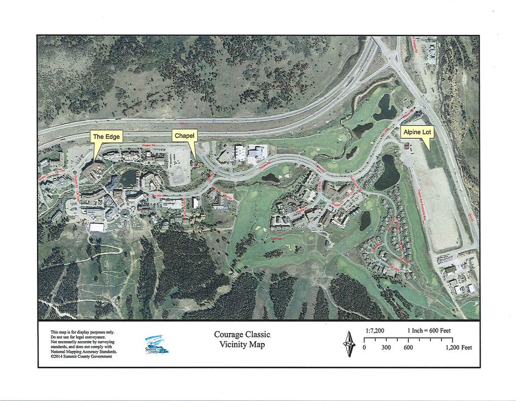
11 nge thora e on ta g Rd (C R 119 7) I W h o u rs Go M remont athf Recp Attachment B CR B Road PLN16-010: TUP - Camping at Chapel Lot for Ride the Rockies Lots A, B, 2, & 3, Block 1, Copper Mountain Subdivision #2 Planning Department Jessica.Potter@summitcountyco.gov (970) CR 8 st e r A Rd Dr 91 R 11 9 a s y Hw Cart Path RD C Fa ir way Ln Haul Rd (C R 1189) 118 6) 1 lf C l er C er P 9 11 r D eel Wh CR e Dr CR 1192 CR ir CR 0 ee l Rec l per Cop Recpath e rs 7 LN ( ou C Ten Mile Cir Un ev acp Rl oint lf 20U ni o n 00 CR er P Go r Coppe path Guller CR Rd 1188 C re ek Tr 94 l CR 11 r 1195 CR Copper Ci Pl CR B e e ler P ler e pp Co d rr Cop p t mon athfre Recp CR I-70 Eastbound Copper Rd e Be d rr 0 Subject Parcels e pp Co ,000 1,500 Feet 2,000 This map is for display purposes only. Do not use for legal conveyance. Not necessarily accurate by surveying standards, and does not comply with National Mapping Accuracy Standards Summit County Government
12 Attachment C
 Fire Access Lane Fire Access Lane Dumpster Porta")
13 Porta Potties Generator Dumpster Attachment D Grey Water Truck Water Truck (2) Fire Access Lane Fire Access Lane Dumpster Porta Potties

14 Attachment E.1 Vendor s Stage Reserved C.N.R.A. Medical Massage

15 Attachment E.2 P.U.D. Approved Tent Camping Center Village- Primary Event Venue Requested T.U.P. Tent & R.V. Camping P.U.D. Approved Tent Camping P.U.D. Approved Tent & R.V. Camping


16 Attachment F: Example of Rules from Courage Classic - Will be the Same for RTR


17 Attachment F: Example of Rules from Courage Classic - Will be the Same for RTR
18 Attachment F: Example of Rules from Courage Classic - Will be the Same for RTR
ORDINANCE NO. JACKSON TOWNSHIP, CAMBRIA COUNTY
 ORDINANCE NO. JACKSON TOWNSHIP, CAMBRIA COUNTY AN ORDINANCE OF THE TOWNSHIP OF JACKSON AMENDING SECTIONS OF THE JACKSON TOWNSHIP ZONING ORDINANCE AS FOLLOWS: PROVIDING NEW DEFINITIONS OF CAMPGROUNDS, CAMPSITE,
b. Minimum Site Area. Recreational vehicle parks shall be located on a parcel of land not less than 3 acres in area.
 6450 RECREATIONAL VEHICLE PARK REGULATIONS 6450 TITLE AND PURPOSE. The provisions of Section 6450 through 6499, inclusive, shall be known as the Recreational Vehicle Park Regulations. The purpose of these
DEPARTMENT OF PLANNING, COMMUNITY & ECONOMIC DEVELOPMENT
 DEPARTMENT OF PLANNING, COMMUNITY & ECONOMIC DEVELOPMENT DATE: December 11, 2015 TO: FROM: SUBJECT: City Council Kevin Cricchio, AICP Associate Planner Department of Planning, Community & Economic Development
CITY OF OCEAN SHORES, WASHINGTON ORDINANCE NO. 940
 CITY OF OCEAN SHORES, WASHINGTON ORDINANCE NO. 940 AN ORDINANCE OF THE CITY COUNCIL OF THE CITY OF OCEAN SHORES, WASHINGTON, AMENDING OCEAN SHORES MUNICIPAL CODE TITLE 15 BUILDINGS AND CONSTRUCTION, CHAPTER
December 11, Planning and Land Development Regulation Commission (PLDRC) 3969 State Road 44, New Smyrna Beach. Glenn Storch, Esquire
 3969 State Road 44, New Smyrna Beach. Glenn Storch, Esquire") 1 of 21 GROWTH AND RESOURCE MANAGEMENT DEPARTMENT PLANNING AND DEVELOPMENT SERVICES DIVISION CURRENT PLANNING ACTIVITY 123 W. Indiana Avenue, DeLand, FL 32720 (386) 943-7059 PUBLIC HEARING: CASE NO: SUBJECT:
1 of 21 GROWTH AND RESOURCE MANAGEMENT DEPARTMENT PLANNING AND DEVELOPMENT SERVICES DIVISION CURRENT PLANNING ACTIVITY 123 W. Indiana Avenue, DeLand, FL 32720 (386) 943-7059 PUBLIC HEARING: CASE NO: SUBJECT:
Development Agreement No. DA16-002
 STAFF REPORT Planning Commission AGENDA ITEM NUMBER 5 MEETING DATE April 13, 2016 CASE NUMBER PROPERTY OWNER PROJECT PROPONENTS City of Buena Park as Successor Agency to the former Community Redevelopment
NOTICE OF PUBLIC HEARING.
 NOTICE OF PUBLIC HEARING. In accordance with Tennessee Code Annotated Section 13-7- 105, the Board of County Commissioners of Blount County, Tennessee, will convene in a called meeting and hold public
Rule Governing the Designation and Establishment of All-Terrain Vehicle Use Trails on State Land
 Rule Governing the Designation and Establishment of All-Terrain Vehicle Use Trails on State Land 1.0 Authority 1.1 This rule is promulgated pursuant to 23 V.S.A. 3506. Section 3506 (b)(4) states that an
ARLINGTON COUNTY, VIRGINIA
 ARLINGTON COUNTY, VIRGINIA County Board Agenda Item Meeting of April 16, 2005 DATE: March 28, 2005 SUBJECTS: A. Adoption of the Fort Myer Heights North Plan. B. GP-300-04-1 Adoption of the following General
Architectural Review Commission
 Architectural Review Commission staff report Item 3: Project Planner: Applicant/Owner: VITALITY BOWLS SIGNAGE APPEAL 100 CRESCENT DRIVE PLN 14-0473 Jeff Olsen, (925) 671-5206, jolsen@ci.pleasant-hill.ca.us
Town of Southern Pines Planning Board Meeting Douglass Community Center 1185 W. Pennsylvania Avenue November 17, 2016 at 7:00 p.m.
 AGENDA Town of Southern Pines Planning Board Meeting Douglass Community Center 1185 W. Pennsylvania Avenue November 17, 2016 at 7:00 p.m. I. Call to Order II. III. Approval of Minutes Public Hearing: CU-07-16:
Bloor Street West Rezoning Application for a Temporary Use By-law Final Report
 STAFF REPORT ACTION REQUIRED 3741 3751 Bloor Street West Rezoning Application for a Temporary Use By-law Final Report Date: June 12, 2007 To: From: Wards: Reference Number: Etobicoke York Community Council
Temporary Campground Plan Review Application
 Procedure to obtain a Temporary Campground Permit Step #1 At least fifteen (15) days prior to the opening of the temporary campground, operators should complete the plan review application (Page #2 to
Priscilla Davenport, Saluda District
 AT A MEETING OF THE MIDDLESEX COUNTY PLANNING COMMISSION HELD ON THURSDAY, NOVEMBER 13, 2003, IN THE PUBLIC MEETING ROOM OF THE COOK S CORNER OFFICE COMPLEX, COOK S CORNER, VIRGINIA. Present: Absent: John
ARTICLE 7 MOBILE HOME AND RECREATIONAL VEHICLE PARKS AND CAMPGROUNDS
 ARTICLE 7 MOBILE HOME AND RECREATIONAL VEHICLE PARKS AND CAMPGROUNDS Section 701. APPLICABILITY Where a municipality has no subdivision or land development ordinance the provisions of this article shall
Parkland County Municipal Development Plan Amendment Acheson Industrial Area Structure Plan
 Parkland County Municipal Development Plan Amendment Acheson Industrial Area Structure Plan New Plan Acheson Industrial Area Structure Plan Amendment Parkland County Municipal Development Plan Board Reference
TOWN OF WARWICK LOCAL LAW NO. 4 OF 2015 A LOCAL LAW TO AMEND THE ZONING LAW
 Local Law Filing NEW YORK STATE DEPARTMENT OF STATE 162 WASHINGTON AVENUE ALBANY, NY 12231 (Use this form to file a local law with the Secretary of State.) Text of law should be given as amended. Do not
Community Development
 Community Development City & Borough of Juneau Community Development 155 S. Seward Street Juneau, AK 99801 (907) 586 0715 Phone (907) 586 4529 Fax DATE: February 11, 2016 TO: FROM: Planning Commission
Town of Hamburg Planning Board Meeting July 26, 2017
 Town of Hamburg Planning Board Meeting July 26, 2017 Minutes The Town of Hamburg Planning Board met for a Work Session at 6:30 P.M., followed by a Regular Meeting at 7:00 P.M. on Wednesday, July 26, 2017
ZC08-06 Rezone request of Charles Leon Saltz from R3 High Density Single Family Residential to B-4 Business and Professional Office
 The Planning & Zoning Commission of the City of Fairhope met Monday, August 4, 2008, at 5:00 PM at the City Administration Building, 161 N. Section Street in the Council Chambers. Present: Jean Wilson,
North Forty Area ( area bounded by Lark Avenue, Los Gatos Boulevard, Highway 85 and
 RESOLUTION 2015-056 RESOLUTION OF THE TOWN COUNCIL OF THE TOWN OF LOS GATOS ADOPTING GENERAL PLAN AMENDMENTS NECESSARY FOR THE NORTH FORTY SPECIFIC PLAN. THE PLAN AREA COMPRISES APPROXIMATELY 44 ACRES
RECREATIONAL VEHICLE EXAMPLES
 RV Ordinance 21.03.010 (I). Recreational Vehicles. 1. Purpose. The purpose of the recreational vehicle (RV) code is to clearly define what is considered a recreational vehicle and to identify locations
AN URGENCY ORDINANCE OF THE COUNTY OF BUTTE CAMP FIRE DISASTER RECOVERY TEMPORARY HOUSING ORDINANCE: 4/5 VOTE REQUIRED
 1 2 Ordinance No. 0 AN URGENCY ORDINANCE OF THE COUNTY OF BUTTE CAMP FIRE DISASTER RECOVERY TEMPORARY HOUSING ORDINANCE: / VOTE REQUIRED The Board of Supervisors of the County of Butte ordains as 7 follows:
CITY OF PALMDALE. REPORT to the Mayor and Members of the City Council from the City Manager
 CITY OF PALMDALE REPORT to the Mayor and Members of the City Council from the City Manager DATE: June 4, 2014 SUBJECT: Specific Plan Amendment 14-01; Amending the Use Designation of 23.97 Acres within
October 10, Planning and Land Development Regulation Commission (PLDRC)
") Page 1 of 21 GROWTH AND RESOURCE MANAGEMENT DEPARTMENT PLANNING AND DEVELOPMENT SERVICES DIVISION 123 West Indiana Avenue, DeLand, Florida 32720 (386) 736-5959 PUBLIC HEARING: CASE NO: SUBJECT: LOCATION:
Page 1 of 21 GROWTH AND RESOURCE MANAGEMENT DEPARTMENT PLANNING AND DEVELOPMENT SERVICES DIVISION 123 West Indiana Avenue, DeLand, Florida 32720 (386) 736-5959 PUBLIC HEARING: CASE NO: SUBJECT: LOCATION:
RIVERDALE CITY CITY COUNCIL AGENDA January 20, 2009 AGENDA ITEM:
 RIVERDALE CITY CITY COUNCIL AGENDA January 20, 2009 AGENDA ITEM: G3 SUBJECT: Consideration of Ordinance #728 adopting a new Chapter under Title 4, Public Health and Safety, Chapter 5b, Camping. PETITIONER:
URBAN DESIGN REPORT. Proposed Residential Development, Old Church Road, Caledon East
 Proposed Residential Development, Old Church Road, Caledon East TABLE CONTENTS: 1.0 DEVELOPMENT 1.1 Introduction-Analysis of Guiding Principles and Documents 1.2 Community Design and Architectural Design
UPPER TOWNSHIP ZONING BOARD OF ADJUSTMENT MEETING MINUTES JUNE 14, 2018
 UPPER TOWNSHIP ZONING BOARD OF ADJUSTMENT MEETING MINUTES The regular meeting of the Upper Township Zoning Board of Adjustment was held at the Township Hall, 2100 Tuckahoe Road, Petersburg, New Jersey.
Hearings will be held in the Shirley Huffman Auditorium in the Charles D. Cameron Public Services Building, 155 North First Avenue, Hillsboro, Oregon.
 Hearings will be held in the Shirley Huffman Auditorium in the Charles D. Cameron Public Services Building, 155 North First Avenue, Hillsboro, Oregon. On September 24, 2013, the Board of County Commissioners
Georgetown-Lewes Rail/Trail Study. Rail/Trail Study: Cool Spring to Cape Henlopen State Park New Road Extension (House Resolution No.
 Georgetown-Lewes Rail/Trail Study Rail/Trail Study: Cool Spring to Cape Henlopen State Park New Road Extension (House Resolution No. 47) August 22, 2011 Presentation Outline Background Benefits Statewide
SUMMER VILLAGE OF SILVER SANDS. Municipal Development Plan
 SUMMER VILLAGE OF SILVER SANDS Municipal Development Plan Bylaw 253-2014 Adopted August 22, 2014 Summer Village of Silver Sands Municipal Development Plan Bylaw No. 253-2014 Page 2 1 INTRODUCTION 1.1 SETTING
CITY OF UMATILLA PLANNING & ZONING AGENDA ITEM STAFF REPORT
 CITY OF UMATILLA PLANNING & ZONING AGENDA ITEM STAFF REPORT DATE: May 5, 2016 MEETING DATE: May 12, 2016 SUBJECT: Olde Mill Stream ISSUE: Ordinance 2016 B, Conditional Use Permit amendment Resolution 2016-07,
SAN MATEO COUNTY AGRITOURISM GUIDELINES
 SAN MATEO COUNTY AGRITOURISM GUIDELINES The San Mateo County Planning and Building Department and the San Mateo County Agricultural Advisory Committee s subcommittee on agritourism have developed the following
D1 January 8, 2014 Public Hearing APPLICANT: HUNT CLUB FARM
 D1 January 8, 2014 Public Hearing APPLICANT: HUNT CLUB FARM PROPERTY OWNER: HUNT CLUB A-1- A, LLC. STAFF PLANNER: Kevin Kemp REQUEST: Modification of a Conditional Use Permit approved by the City Council
LIVONIA JOINT ZONING BOARD OF APPEALS MEETING MINUTES- November 3, 2014
 LIVONIA JOINT ZONING BOARD OF APPEALS MEETING MINUTES- November 3, 2014 Present: Chair P. Nilsson, C. Rider, M. Sharman, G. Cole, Code Enforcement Officer A. Backus, Recording Secretary J. Brown Absent:
Proposal to Redevelop Lower Kananaskis River-Barrier Lake. Bow Valley Provincial Park. Frequently Asked Questions
 Proposal to Redevelop Lower Kananaskis River-Barrier Lake Bow Valley Provincial Park Frequently Asked Questions What is being proposed? What are the details of the proposal? Where is the project area located?
NOTE: YOU MAY COMPLETE THIS SURVEY ONLINE (USING THIS DOCUMENT TO VIEW MAPS AND GRAPHICS) AT:
 AT:") for completing the Town of Beech Mountain Comprehensive Planning Survey. The information you provide in reply to the following questions will be used to help the Town develop a plan that will guide our
for completing the Town of Beech Mountain Comprehensive Planning Survey. The information you provide in reply to the following questions will be used to help the Town develop a plan that will guide our
ROAD AND TRAIL PROJECT APPROVAL
 ROAD AND TRAIL PROJECT APPROVAL www.marincountyparks.org Marin County Parks, 3501 Civic Center Dr, Suite 260, San Rafael, CA 94903 DATE: July 12, 2017 PRESERVE: Gary Giacomini Open Space Preserve PROJECT:
Northwest Triangle. Redevelopment Proposal. Property Acquisition, Engineering, and Demolition. December, 2005 REDEVELOPMENT AUTHORITY OF THE
 Northwest Triangle Redevelopment Proposal Property Acquisition, Engineering, and Demolition December, 2005 REDEVELOPMENT AUTHORITY OF THE CITY OF YORK York City Redevelopment Authority 14 West Market Street,
STAFF REPORT. Airport Land Use Consistency Determination Betteravia Plaza. MEETING DATE: January 21, 2016 AGENDA ITEM: 8D
 STAFF REPORT SUBJECT: Airport Land Use Consistency Determination Betteravia Plaza MEETING DATE: AGENDA ITEM: 8D STAFF CONTACT: Andrew Orfila RECOMMENDATION: Adopt findings for the Betteravia Plaza project
Section 61 Recreational Vehicle Park / Campground (Bylaw No. 2012/10)
") Part 7 General Regulations Section 61 Recreational Vehicle Park / Campground (Bylaw No. 2012/10) 61.1 A comprehensive site plan shall be provided to the satisfaction of the Development Authority that shows
Part 7 General Regulations Section 61 Recreational Vehicle Park / Campground (Bylaw No. 2012/10) 61.1 A comprehensive site plan shall be provided to the satisfaction of the Development Authority that shows
COUNCIL REPORT Meeting Date: December 10, 2013
 Subject: Highway 63/881 Corridor Area Structure Plan Amendment Bylaw No. 13/037 APPROVALS: Felice Mazzoni, Director Henry Hunter, Executive Director Glen Laubenstein, Chief Administrative Officer COUNCIL
City of Cedar Hill Planning and Zoning Commission February 5, MINUTES PLANNING AND ZONING COMMISSION Meeting of February 5, 2007
 Page 1 of 9 MINUTES PLANNING AND ZONING COMMISSION Meeting of The of the, Texas met on MONDAY, at 6:00 p.m. in the Council Chambers of City Hall, Cedar Hill, Texas. Present: Chairman Detrick Deburr, Vice-Chairman
4.0 Context for the Crossing Project
 4.0 Context for the Crossing Project This section provides background information about key features of the North Douglas Crossing project area, and opportunities and constraints. This information is important
DRAFT GENERAL IMPLEMENTATION PLAN AND SPECIFIC IMPLEMENTATION PLAN MIDDLETON MUNICIPAL AIRPORT MOREY FIELD. Revised 12/12/03
 DRAFT GENERAL IMPLEMENTATION PLAN AND SPECIFIC IMPLEMENTATION PLAN MIDDLETON MUNICIPAL AIRPORT MOREY FIELD Revised 12/12/03 As recommended for approval by the Plan Commission General Project Description
Ordinance Number Snowmobiles and ATVs. Replaces pages See also Section County ATV Ordinance.
 Ordinance Number 05-2009 Snowmobiles and ATVs Replaces pages 900-28 - 900-29 See also Section 905.2.2 County ATV Ordinance Amended 02-15-11 ORDINANCE NO. 05-2009 WHEREAS, the use of snowmobiles and All
SEASONAL CAMPGROUND ADMISSION AGREEMENT
 1SEASONAL CAMPER AGREEMENT FOR 2012 (Final) 2 1 SEASONAL CAMPGROUND ADMISSION AGREEMENT 2 3 THIS AGREEMENT IS BETWEEN THE CAMPGROUND,, AND 4THE FOLLOWING PERSONS: 5ADULTS:. 6MINORS:. 7ONLY THE PERSONS
MESA COUNTY DEPARTMENT OF PUBLIC WORKS Administration - Building - Engineering Road and Bridge Traffic - Planning - Solid Waste Management
 MESA COUNTY DEPARTMENT OF PUBLIC WORKS Administration - Building - Engineering Road and Bridge Traffic - Planning - Solid Waste Management 200 S. Spruce St. P.O. Box 20,000 Grand Junction, Colorado 81502-5022
Minutes of the Tuesday May 22, 2018 Planning and Zoning Commission Meeting
 Minutes of the Tuesday May 22, 2018 Planning and Zoning Commission Meeting The May 22 nd, 2018 Regular Planning and Zoning Commission meeting was called to order at 6:00 pm. Roll Call. The Following Commissioners
COASTAL CONSERVANCY. Staff Recommendation December 2, 2004 COYOTE HELLYER COUNTY PARK BAY AREA RIDGE TRAIL
 COASTAL CONSERVANCY Staff Recommendation December 2, 2004 COYOTE HELLYER COUNTY PARK BAY AREA RIDGE TRAIL File No. 04-057 Project Manager: Amy Hutzel RECOMMENDED ACTION: Authorization to disburse up to
Official Minutes of MARION COUNTY BOARD OF COUNTY COMMISSIONERS. May 8, 2018
 Official Minutes of MARION COUNTY BOARD OF COUNTY COMMISSIONERS May 8, 2018 CALL TO ORDER: The Marion County Board of County Commissioners met in a special session in Commission Chambers at 5:33 p.m. on
Longmont to Boulder Regional Trail Jay Road Connection DRAFT FINAL REPORT
 Longmont to Boulder Regional Trail Jay Road Connection DRAFT FINAL REPORT December 2018 Project Summary Boulder County, Colorado, in partnership with the City of Boulder, is evaluating options for multi-use
APPLICATION FOR SITE DEVELOPMENT PLAN LETTER OF INTENT Amended
 Est. 1982 Est. 1982 Urban Planning Community Design Landscape Architecture 731 North Weber Street, Suite 10, Colorado Springs, CO 80903, 719 633-9700 http://www.gumanltd.com/ Members American society of
TOWN OF SILVERTHORNE PLANNING COMMISSION MEETING MINUTES SEPTEMBER 1, :00 P.M.
 TOWN OF SILVERTHORNE PLANNING COMMISSION MEETING MINUTES SEPTEMBER 1, 2015 6:00 P.M. 1. CALL TO ORDER The meeting was called to order at 6:00 p.m., on September 1, 2015, in the Council Chambers of the
CITY OF PALMDALE LOS ANGELES COUNTY, CALIFORNIA RESOLUTION NO. CC
 CITY OF PALMDALE LOS ANGELES COUNTY, CALIFORNIA RESOLUTION NO. CC 2010-087 A RESOLUTION OF THE CITY COUNCIL OF THE CITY OF PALMDALE, CALIFORNIA, APPROVING SPECIFIC PLAN AMENDMENT 10-01, AMENDING THE PALMDALE
MONTGOMERY COUNTY PLANNING DEPARTMENT THE MARYLAND-NATIONAL CAPITAL PARK AND PLANNING COMMISSION
 MONTGOMERY COUNTY PLANNING DEPARTMENT THE MARYLAND-NATIONAL CAPITAL PARK AND PLANNING COMMISSION Three Sisters Road: Abandonment No. AB740 MCPB Item No. 11 Date: 5-1-14 Katherine Holt, Senior Planner,
MUNICIPALITY OF ANCHORAGE
 DATE: June 3, 2009 MUNICIPALITY OF ANCHORAGE PARKS & RECREATION DEPARTMENT MEMORANDUM PRC #09-35 TO: FROM: SUBJECT: Parks and Recreation Commission Tom Korosei, Park Planner Proposed Land Exchange for
Memorandum / Letter of Intent
 VERONA WAUKESHA KENOSHA APPLETON WESTON Memorandum / Letter of Intent To: Adam Sayre, Director of Planning & Development, City of Verona From: Kevin Yeska, JSD Professional Services, Inc. www.jsdinc.com
PLANNING COMMISSION AGENDA REPORT May 10, Members of the Planning Commission. Joyce Parker-Bozylinski, Contract Planner
 PLANNING COMMISSION AGENDA REPORT May 10, 2007 TO: FROM: PROPOSAL: APPLICANT: RECOMMENDATION: Members of the Planning Commission Joyce Parker-Bozylinski, Contract Planner Approval of the Calabasas Trails
PRELIMINARY STAFF PLANNING REPORT TO THE WALWORTH COUNTY ZONING AGENCY X CONDITIONAL USE
 This report was prepared prior to the public hearing. This report may be supplemented or amended to reflect the review of additional information presented at the public hearing and written material submitted
REGIONAL BOARD REPORT
 REGIONAL BOARD REPORT Administrator s Office For the Board August 21, 2008 DATE: August 14, 2008 FILE NOS.: A-07-06377/8/9.000 FROM: RE: Chief Administrative Officer OCP and Zoning Amendment Application
BOARD REPORT. TO: Chair and Directors File No: BL PL
 BOARD REPORT TO: Chair and Directors File No: BL 825-38 PL20180175 SUBJECT: Electoral Area F: Scotch Creek/Lee Creek Amendment (Pinegrove RV Park) Bylaw No. 825-38 DESCRIPTION: Report from Dan Passmore,
Airport Planning Area
 PLANNING AREA POLICIES l AIRPORT Airport Planning Area LOCATION AND CONTEXT The Airport Planning Area ( Airport area ) is a key part of Boise s economy and transportation network; it features a multi-purpose
SARPY COUNTY PLANNING COMMISSION MINUTES OF MEETING June 20, 2017
 SARPY COUNTY PLANNING COMMISSION MINUTES OF MEETING l. CALL MEETING TO ORDER A meeting of the of Sarpy County, Nebraska was convened in open and public session at the call of Chairman Tom Ackley at 7:00
Official Plan Amendment No 76 Airport and Employment Hearing 2011 P a g e 1
 Official Plan Amendment No 76 Airport and Employment Hearing 2011 P a g e 1 8(f) 2.2.3 Managing Growth Within the Urban Area Employment 19. In all urban communities outside the Central Area, opportunities
1 #N7 AMX42TOD4BVTv1
 ntroduced by: ORDNANCE NO. AN ORDNANCE OF THE CTY OF PASADENA AMENDNG TTLE 17 (ZONNG CODE) OF THE PASADENA MUNCPAL CODE TO ALLOW THE CONVERSON OF HOTELS AND MOTELS TO AFFORDABLE HOUSNG, AND AMENDNG TTLE
Commission SUMMARY: 12, Action. review. hearing is. being. 601 E Kennedy Blvd., 18
 Hillsborough County City-Countyy Planning Commission 601 E Kennedy Blvd., 18 th floor, Tampa, Florida, 33601 813-272-5940 theplanningcommission.org EXECUTIVE SUMMARY Meeting Date: August 12, 2013 Agenda
377 Spadina Rd & 17 Montclair Ave Zoning Amendment Application Final Report
 STAFF REPORT ACTION REQUIRED 377 Spadina Rd & 17 Montclair Ave Zoning Amendment Application Final Report Date: September 14, 2016 To: From: Wards: Reference Number: Toronto and East York Community Council
Springfield Township Planning Commission Workshop Meeting Minutes of March 3, 2005
 Springfield Township Planning Commission Workshop Meeting Minutes of March 3, 2005 Call to Order: Chairperson Roger Lamont called the March 3, 2005 Workshop Meeting of the Springfield Township Planning
DEPARTMENT OF PLANNING JEFFERSON PARISH, LOUISIANA
 DEPARTMENT OF PLANNING JEFFERSON PARISH, LOUISIANA DESIGN REVIEW REPORT : CPZ-3-5 ADVERTISING DATES: 03/25/5 04/0/5 04/08/5 : 2425 PUBLIC HEARING: 04/6/5 S: HEARING: 05/3/5 : Ricky J. Templet Chris Roberts,
March 4, Mr. H. Dale Hemmerdinger Chairman Metropolitan Transportation Authority 347 Madison Avenue New York, NY Re: Report 2007-F-31
 THOMAS P. DiNAPOLI STATE COMPTROLLER 110 STATE STREET ALBANY, NEW YORK 12236 STATE OF NEW YORK OFFICE OF THE STATE COMPTROLLER March 4, 2008 Mr. H. Dale Hemmerdinger Chairman Metropolitan Transportation
PART I GENERAL INFORMATION OF KENT COUNTY WATER AUTHORITY
 PART I GENERAL INFORMATION OF KENT COUNTY WATER AUTHORITY 1.1 BACKGROUND: The Kent County Water Authority was created by Chapter 1740 of the January Session 1946 of the General Assembly of the State of
Rural Rustic Road Program
 Virginia Department of Transportation s Rural Rustic Road Program Prepared by the Local Assistance Division Virginia Department of Transportation 1401 East Broad Street Richmond, Virginia 23219 Michael
Is designed to provide seasonal or temporary living quarters for camping and which may be connected to utilities.
 ZS 1-318. Campgrounds. (a) Definitions. For the purposes of this section, the following definitions shall strictly apply: CABIN A structure built on a permanent foundation or attached to a permanent chassis
2433 Dufferin Street Zoning By-law Amendment Application - Preliminary Report
 STAFF REPORT ACTION REQUIRED 2433 Dufferin Street Zoning By-law Amendment Application - Preliminary Report Date: July 22, 2014 To: From: Wards: Reference Number: North York Community Council Director,
Continental Divide National Scenic Trail Legislative History and Planning Guidance
 Continental Divide National Scenic Trail Legislative History and Planning Guidance Legislation, Policy, and Direction Regarding National Scenic Trails The National Trails System Act, P.L. 90-543, was passed
The Summit County Open Space and Trails Regulations
 The Summit County Open Space and Trails Regulations ADOPTED PURSUANT TO RESOLUTION NO. 2007-59 ON AUGUST 14, 2007 AMENDED PURSUANT TO RESOLUTION NO. 2015-55 ON OCTOBER 16, 2015 Section 1. Intent The Summit
VILLAGE OF ALGONQUIN PLANNING AND ZONING COMMISSION Meeting Minutes William J. Ganek Municipal Center-Board Room February 13, :30 p.m.
 VILLAGE OF ALGONQUIN PLANNING AND ZONING COMMISSION Meeting Minutes William J. Ganek Municipal Center-Board Room February 13, 2017 7:30 p.m. AGENDA ITEM 1: Present: Absent: Staff Members Present: Roll
The following criteria shall be applied within the boundaries of the AO District:
 Sec. 419 (a) Purpose AIRPORT OVERLAY DISTRICT (AO) The purpose of the Airport Overlay District is to regulate and restrict the height of structures, objects, or natural growth, regulate the locations of
LAND USE GUIDELINES NEW TOWN
 VI LAND USE A L T ETruRck TNraiAl T I V E S AarNnelDla D E S I G N W GUIDELINES NEW TOWN ad Ro DAVEN CA LF IRE ALTERNATIVE LAND USE PLANS AND DESIGN GUIDELINES - VI VI LAND USE ALTERNATIVES Asilomar Hotel
Staff Report Sign Design
 Staff Report Sign Design July 29, 2014 Planning & Zoning Commission Meeting Report date July 23, 2014 Project type Sign Design Legal description Section 2, Township 5, Range 82 Lots 3&4, S1/2NW1/4, SW1/4
Thornton Water Project. Larimer County Route Study and Project Update September 12, 2017
 Thornton Water Project Larimer County Route Study and Project Update September 12, 2017 Purpose of Meeting Provide information on the Thornton Water Project Present the results of the pipeline routing
ISTRIO MUNICIPALITY OF MUSKOK
 ISTRIO MUNICIPALITY OF MUSKOK.- -..-.. -.-... -- PLANNING AND ECONOMIC DEVELOPMENT DEPARTMENT 70 PINE STREET, BRACEBRIDGE, ONTARIO PI L 1 N3 Telephone (705) 645-2231 OR 1-800-461-4210 (705 area code) Fax
Concept Curtin Precinct Map and Code
 Concept Curtin Precinct Map and Code Proposed changes from the revised Curtin Group Centre Draft Master Plan recommendations Disclaimer: This document is intended to show the proposed changes to the existing
Village of Glenview Appearance Commission
 STAFF REPORT December 5, 2012 Village of Glenview Appearance Commission TO: Chairman and Appearance Commissioners FROM: Planning and Economic Development Department CASE MANAGER: Tony Repp, Planner SUBJECT:
2.2 For these reasons the provision of tourist signing will only be considered:
 TOURIST SIGNING POLICY 2015 1. DEFINITION 1.1 A tourist destination is defined as a permanently established attraction which attracts or is used by visitors to an area and is open to the public without
RIO ARRIBA COUNTY BOARD OF COUNTY COMMISSIONERS ORDINANCE NO RIO ARRIBA COUNTY TRAVEL TRAILER CAMPGROUND REGULATIONS
 RIO ARRIBA COUNTY BOARD OF COUNTY COMMISSIONERS ORDINANCE NO. 1992-03 RIO ARRIBA COUNTY TRAVEL TRAILER CAMPGROUND REGULATIONS EFFECTIVE: DECEMBER 18, 1992 ADOPTED: OCTOBER 19, 1992 JOE B. ROMERO, CHAIRMAN
REGIONAL WATER QUALITY MANAGEMENT PLAN WALWORTH COUNTY METROPOLITAN SEWERAGE DISTRICT / ELKHORN SANITARY SEWER SERVICE AREA
 AMENDMENT TO THE REGIONAL WATER QUALITY MANAGEMENT PLAN WALWORTH COUNTY METROPOLITAN SEWERAGE DISTRICT / ELKHORN SANITARY SEWER SERVICE AREA AS ADOPTED BY THE SOUTHEASTERN WISCONSIN REGIONAL PLANNING COMMISSION
Draft for approval by TCC on 2/3, TAQC on 2/9 and ARC Board on 2/22. Regional Trail Plan. Mike Alexander, Director, Center for Livable Communities
 DATE: February 3, 2017 ISSUE SUMMARY: Regional Trail Plan FROM: Mike Alexander, Director, Center for Livable Communities IMPORTANCE: In May 2016, ARC adopted the active transportation component of the
TOURISM & PUBLIC SERVICES RURAL SIGNAGE POLICY
 Policy and Procedures Subject Title: Tourism and Public Services Rural Signage Policy Corporate Policy (Approved by Council): X Policy Ref. No.: ROADS-01-07 Administrative Policy (Approved by CAO): By-Law
Community Development Committee
 C Community Development Committee For the Metropolitan Council meeting of October 31, 2012 Committee Report Item:2012-316 ADVISORY INFORMATION October 16, 2012 Date Prepared: Subject: Intercity Regional
OFFICE OF THE PLANNING COMMISSION City Hall Holland, Michigan
 OFFICE OF THE PLANNING COMMISSION City Hall Holland, Michigan Planning Commission Report Report 4 To: Mayor DeBoer and Members of the Holland City Council Date: May 25, 2016 Subject: 11th Street Rezoning
CITY OF ANAHUAC ORDINANCE NO RECREATIONAL VEHICLE PARKS
 CITY OF ANAHUAC ORDINANCE NO. 2014-04-04 RECREATIONAL VEHICLE PARKS AN ORDINANCE OF THE CITY OF ANAHUAC, TEXAS REGARDING THE PLACING AND LOCATION OF RECREATIONAL VEHICLE PARKS TO BE LOCATED WITHIN THE
Madison Metro Transit System
 Madison Metro Transit System 1101 East Washington Avenue Madison, Wisconsin, 53703 Administrative Office: 608 266 4904 Fax: 608 267 8778 TO: FROM: SUBJECT: Plan Commission Timothy Sobota, Transit Planner,
REGULAR MEETING OF THE KENNER CITY COUNCIL DECEMBER 7, :00P.M. COUNCIL CHAMBER- KENNER CITY HALL SUPPLEMENTAL AGENDA PUBLIC APPEARANCE AGENDA
 REGULAR MEETING OF THE KENNER CITY COUNCIL DECEMBER 7, 2017-5:00P.M. COUNCIL CHAMBER- KENNER CITY HALL SUPPLEMENTAL AGENDA PUBLIC APPEARANCE AGENDA 13. RESOLUTIONS AND MOTIONS BY COUNCILMEMBERS 13-H. A
EAST DON TRAIL ENVIRONMENTAL ASSESSMENT. Community Liaison Committee Meeting #3 July 15, :30 to 8:30 pm Flemingdon Park Library
 EAST DON TRAIL ENVIRONMENTAL ASSESSMENT Community Liaison Committee Meeting #3 July 15, 2013 6:30 to 8:30 pm Flemingdon Park Library Agenda 1. Welcome 2. Housekeeping and Updates a) Housekeeping b) CLC
SAMTRANS TITLE VI STANDARDS AND POLICIES
 SAMTRANS TITLE VI STANDARDS AND POLICIES Adopted March 13, 2013 Federal Title VI requirements of the Civil Rights Act of 1964 were recently updated by the Federal Transit Administration (FTA) and now require
STAFF REPORT. Airport Land Use Plan Consistency Review: Old Town Village Mixed Use Project City of Goleta. MEETING DATE: June 18, 2015 AGENDA ITEM: 5M
 STAFF REPORT SUBJECT: Airport Land Use Plan Consistency Review: Old Town Village Mixed Use Project City of Goleta MEETING DATE: AGENDA ITEM: 5M STAFF CONTACT: Peter Imhof, Andrew Orfila RECOMMENDATION:
AGENDA ITEM 5 D WAKULLA ENVIRONMENTAL INSTITUTE (WEI) TRAIL FEASIBILITY STUDY
 TRAIL FEASIBILITY STUDY") March 19, 2018 AGENDA ITEM 5 D WAKULLA ENVIRONMENTAL INSTITUTE (WEI) TRAIL FEASIBILITY STUDY TYPE OF ITEM: Action STATEMENT OF ISSUE The Wakulla Environmental Institute (WEI) Trail is one of several trails
March 19, 2018 AGENDA ITEM 5 D WAKULLA ENVIRONMENTAL INSTITUTE (WEI) TRAIL FEASIBILITY STUDY TYPE OF ITEM: Action STATEMENT OF ISSUE The Wakulla Environmental Institute (WEI) Trail is one of several trails
Executive Summary Downtown Park Fund Allocation HEARING DATE: MAY 5, 2016
 Executive Summary Downtown Park Fund Allocation HEARING DATE: MAY 5, 2016 Date: April 28, 2016 Case No.: 2016 004634CWP Project Name: Allocation of $4,000,000 from the Downtown Park Fund for the Renovation