DRAFT DRAFT DRAFT. Fish, Numbered & Question Lakes Area Recreation Managment Plans. Issues and Preliminary Recommendations
|
|
|
- Kristina Newman
- 5 years ago
- Views:
Transcription

1 DRAFT DRAFT DRAFT Fish, Numbered & Question Lakes Area Recreation Managment Plans Issues and Preliminary Recommendations Prepared for Matanuska-Susitna Borough, Department of Land Management by Agnew::Beck Consulting March 2006
2
3 Fish, Numbered and Question Lakes Area Recreation Management Plans Table of Contents Project Background & Overview...1 Planning Process...2 Project Area Features & Use...4 Fish Lake Area...7 Numbered and Question Lakes Area...14 Recommended Management...19 Policy Recommendations for Fish Lake...22 Policy Recommendations for Numbered & Question Lakes...32 Implementation Issues...41 References...43 Table of Maps Project Area Map...5 Public Parks and Recreation Areas in Talkeetna Map...6 Land Ownership Map...9 Soil Map for the Fish Lake Area...10 Topography Map...11 Soil Map for the Numbered and Question Lakes Area...16 Preliminary Draft TABLE OF CONTENTS i
4 ii TABLE OF CONTENTS Preliminary Draft
5 PROJECT BACKGROUND & OVERVIEW It was recommended in the 1998 Talkeetna Comprehensive Plan that certain Matanuska-Susitna Borough (MSB) lands in the Talkeetna vicinity be reserved for park and preservation. 1 The specific areas identified were a portion of State and Borough lands around X, Y, Z and Tigger Lakes, a portion of contiguous Borough land north of Fish Lake, and a portion of Borough land Land ownership in the Talkeetna area is predominately private, Native Corporation, or University of Alaska. As this property is subdivided and developed, there will not be the natural open space that we now take for granted. Our parks will become ever more valuable as refuges for wildlife and for people seeking nature and a quiet outdoor experience. From Concept: Talkeeetna Numbered Lakes Natural Area, prepared by a group of local residents around Numbered Lakes. In October 2005, the Talkeetna Community Council requested that the MSB reclassify a portion of the Numbered Lakes and Fish Lake areas as Park and Preserve, and develop a park and preserve master plan for the area. In early 2006, Agnew::Beck Consulting, LLC of Anchorage was awarded the contract to work with MSB staff and the community to prepare Recreation Management Plans for these lands (see Project Area map on page 5). With the exception of one parcel (the southwestern most 40 acre parcel that straddles the Spur Road is classified as material land ), the MSB lands identified in this planning effort remain unclassified. After evaluating site opportunities and constraints, use patterns, and considering public opinion, this planning effort will ultimately classify the MSB lands considered in this plan for particular uses (e.g., public recreation land, private recreation land). Several past planning efforts have been completed in the Talkeetna area that provide context for this work. These include: The Talkeetna Comprehensive Plan, The Talkeetna Lakes (XYZ Lakes) Recreation Plan, 2003; a Land Use Plan and Economic Development Strategy for the Talkeetna Riverfront Park, 2003; and a Lake Management Plan for the Question, Little Question, Lake Five and Unnamed Lakes, See the list of references at the end of this document for a complete listing of past planning efforts, ecological studies and background information. The Fish, Numbered and Question Lakes Area Recreation Management Plans will consider and seek consistency with these past planning efforts. The Matanuska-Susitna Borough encourages the development of a plan to guide the future use of any Borough lands classified for public recreation or preservation where public interest is high and there are competing views regarding future uses. 1 Talkeetna Comprehensive Plan, 1998, Matanuska-Susitna Borough (pages 6-38, 6-40) Preliminary Draft PROJECT BACKGROUND & OVERVIEW 1
6 PLANNING PROCESS The planning process allows community members to set goals for and to determine what, if any, improvements (e.g., trails, parking) or management strategies (e.g., controls on type of trail use) are necessary to reach these goals. The process began with a public meeting on March 8, The primary goal of this meeting was to identify the area s physical characteristics, natural habitat, current uses and access routes. Meeting attendants were also able to convey some initial goals and vision for the future of the areas. Additional public meetings will allow for public comment on the compilation of background information regarding the characteristics of these sites, as well as review draft plans that set out recommended management for these areas. Revisions will be made to the draft plans based on public feedback. The document will then be presented to the Talkeetna Community Council for their review and approval. Once the Community Council approves this plan, it will go to the Matanuska Susitna Borough Parks and Recreation Advisory Board, Real Property Asset Management Advisory Board, the Matanuska- Susitna Borough Planning Commission, and Assembly for final review and approval. Who is involved? Talkeetna Parks Advisory Committee Talkeetna Community Council Residents and landowners near study area Matanuska-Susitna Borough, Land & Resource Management representatives Agnew::Beck Consulting, working as the prime consultant Role of the Advisory Committee The Borough establishes local Advisory Committees whenever there are diverse views on best management of a public recreation area. As stated in the Talkeetna Comprehensive Plan, it is recommended that a citizens Park Advisory Board be created to guide the management of these and other area parks in order to maximize both their wildlife habitat and compatible recreation values. The Talkeetna Parks Advisory Committee is comprised of a core committee and an at-large committee. This committee, chaired by Chris Mannix, guides the development of this plan for management and improvements to the area. Affected Agencies State of Alaska Department of Natural Resources (DNR) own tracts of land that are adjacent to the study areas. Cook Inlet Regional Inc. (CIRI) owns a large area of land, primarily east of the study areas. The University of Alaska owns tracts of land that are adjacent to the study areas. 2 PLANNING PROCESS Preliminary Draft
7 State of Alaska Department of Transportation and Public Facilities (DOT&PF) may be involved with any parking improvements and maintenance along the road. Project Timeline Date Action The Talkeetna Comprehensive Plan recommends portions of MSB land 1998 around Fish and Numbered Lakes be reserved for park and preservation. The Talkeetna Community Council requests the MSB reclassify the October 2005 land as Park and Preserve, and develop a park and preserve master plan for the area. February 06 Agnew::Beck was awarded contract to prepare a Recreation Plan. February 06 Publicity of the project began with flyer posted around community; informational postcards were sent to over 200 adjacent landowners. March 8 06 Initial site visit and meeting with the local Parks Advisory Committee and interested community members. March 06 Prepare Issues and Preliminary Recommendations and review with MSB staff, Parks Advisory Committee and other key stakeholders March 06 Distribute Issues and Preliminary Recommendations for community review April 5 06 Community Workshop #1 April 06 Revise Preliminary Recommendations to create Draft Plan April 06 Release Draft Plan for community review May 06 Community Workshop #2 May 06 Revise and finalize Plans May 06 Community Council meets to approve Plans June 06 Matanuska-Susitna Borough Advisory Boards, Planning Commission and Assembly approve Plans Preliminary Draft PLANNING PROCESS 3
8 PROJECT AREA FEATURES & USE The lands considered in this plan are owned and managed by the Matanuska-Susitna Borough and are located within the Talkeetna Community Council area. Talkeetna is an unincorporated community. Separate goals, policies, implementation strategies will be developed in two different regions: Fish Lake Area (land north of Fish Lake) and Numbered and Question Lakes Area (parcel around Numbered Lakes and small parcel west of Question Lake). See Project Area map on the following page for the location of study area parcels. Because the uses, access, land ownership, physical environment, etc. are different among the parcels, it is important to differentiate the two regions and set policies separately. Other Public Lands in the Area Talkeetna has a variety of public lands that serve as parks or are used for recreational activities. Decisions on the future use of the Fish, Numbered and Question Lakes areas will need to reflect the range of recreation options in the community. Close to downtown is the Village and Riverfront Park which is small but heavily used, both by residents and summer tourists. Amenities include overnight camping, picnicking, fishing, yearround trail and river access, parking and boat launch facilities. This area is owned by the Alaska Railroad, the state and the MSB. This is the most heavily used, extensively developed recreation site in the Talkeetna area. About a mile and a half southeast of downtown is Christiansen Lake Park, a large day-use park that principally provides fishing, boating and swimming. A mile farther south is the Talkeetna Lakes Park (the X, Y, Z and Tigger Lakes area), a larger park that is MSB owned and reserved for public recreation use. This area is road-accessible yet largely undeveloped. Only nonmotorized activities are permitted which attracts activities such as skiing, fishing, dog mushing, mountain biking, hiking, canoeing and camping. This area lies a few miles north of Fish Lake. See the Public Parks and Recreation Areas in Talkeetna map on page 6 for an approximate location of these parks. Improvements underway or planned in this area include a walking, biking and ski trail system and associated trail head parking areas. These areas have been used for generations by the local community. Not till recently have these areas been formally identified as parks, and infrastructure and recreational development been established. Separate plans for the Riverfront Park and the Talkeetna Lakes Park were completed in PROJECT AREA FEATURES & USE Preliminary Draft


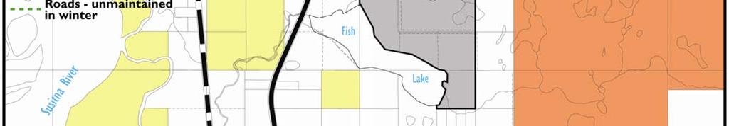
9 Project Area Map Preliminary Draft PROJECT AREA FEATURES & USE 5


10 Public Parks and Recreation Areas in Talkeetna Map 6 PROJECT AREA FEATURES & USE Preliminary Draft
11 FISH LAKE AREA Fish Lake itself is located at approximately mile 9 of the Spur Road, just east of the road. Downtown Talkeetna is approximately 5 miles northwest. The MSB parcel that is the focus of this plan covers approximately 240 acres. Land Ownership and Land Use in the Surrounding Area The Borough land at Fish Lake is completely surrounded by private property and Fish Lake itself. See the Land Ownership map on page 9. As discussed further below, Fish Lake is a popular public recreation destination, but currently nearly all this use crosses the private lands along the Spur Road at the west end of the lake. Adjoining private property is primarily used for low density residential uses, both for year-round and second homes. About half the parcels in the immediate vicinity of the Fish Lake parcel have been developed. Parcels with homes or cabins include a cluster of residential uses at the southeastern end of Fish Lake, and a few developed parcels on the north, east and west sides of the Borough parcel. Access to the Area This Fish Lake MSB parcel is surrounded by private property, with no public constructed roads leading to any portion or access point. Users access the area from their own property, private driveways, other people s private property or along undeveloped public right-of-ways (ROW). The land owner who owns the land between the Spur Road and Fish Lake (and those who lease from him) currently allows people to park on and cross through his property to access the lake, the MSB land or private property adjoining the lake or on the eastern end of the study area. Other users travel by boat to an informal trailhead at the east end of the lake at which point they hike through the Borough parcel to their cabins. There is also an undeveloped public ROW that extends east from the Spur Road and enters the northern portion of the project area. Residential users south of Fish Lake enter the area on a private driveway that heads north from South Birch Creek Blvd. As is discussed further below, the area east of the Fish Lake is primarily wetlands. This area is used for access in the winter, but is a barrier to travel during summer months. Physical Environment Topography The Fish Lake parcel has rolling, variable, glacial-created topography with a complex pattern of mounds, ridges and more level areas. In general, the land slopes south towards the lake, with a relatively steep slope along the shoreline, creating a pleasant sunny, southern exposure. The map on page 11 shows the topography of this area. Hydrology With the exception of the southern portion of the area and the two lakes in the northeast, this area is primarily high and dry. What the locals call Gator Creek, an anadromous salmon stream just west of the project boundary, flows south into Fish Lake. (The most accessible public ROW, mentioned in the Access to the Area section earlier in this chapter, crosses this stream bed.) Preliminary Draft PROJECT AREA FEATURES & USE 7
12 Upper Birch Creek flows west from the Bartlett Hills into Fish Lake. It then drains from the western end of lake and turns into Lower Birch Creek. The Citizens Water Monitoring group is in its 5 th year of upper and lower Birch Creek monitoring. The eastern portion of the area is primarily wetlands, allowing for easy winter travel and vistas across the lake. Portions of two unnamed lakes extend into the northeast portion of the project area The topographic map on page 11 provides a good summary of the streams and lakes in the area; the soils map on page 10 shows the boundaries of the wetlands. Vegetation Vegetation includes a mix of forested and marshy areas. The forest is relatively open and walkable in some areas but thick with devil s club, high bush cranberries and additional brush in other sections. Black spruce and mixed birch are the dominant trees; alder and willow shrubs are also found. The wetland areas are primarily muskeg (peat bog) which provides a home for an abundance of plants that thrive in wet, acid soil; sphagnum moss is the mainstay. This mix of forests and wetlands contribute to the area s significant habitat values. Wildlife This area is home to a variety of wildlife and also provides migratory corridors for a number of species. Wildlife found in the area includes beaver, river otter, bear, moose and fox. (Over a recent, four month summer stretch, one resident at the east end of the lake reported seeing 33 moose and 8 bear.) Birds in the area include swans, cranes, eagles, gray owls, scoters, long-tail ducks, loons and red-necked grebes. Fish in the area includes anadromous coho salmon, Chinook salmon, sockeye salmon, rainbow trout, Dolly Varden, long-nose suckers and stickleback. Unlike a number of other lakes in the Talkeetna area, Fish Lake and the smaller lakes to north are not stocked by the Alaska Department of Fish and Game (ADF&G). The Fish Lake parcel has a strategic location between the paths of two important anadromous fish stream systems Gator Creek to the north and Upper and Lower Birch Creeks to the east and west. As a result, this area functions as an important wildlife corridor, for black and brown bears and other species, linking the Bartlett Hills to the Susitna River. 8 PROJECT AREA FEATURES & USE Preliminary Draft


13 Land Ownership Map Preliminary Draft PROJECT AREA FEATURES & USE 9


14 Soil Map for the Fish Lake Area This map may contain errors, may not be current, and may omit important information. This map is solely a representation of real-world conditions and is made available to for informational purposes only. 10 PROJECT AREA FEATURES & USE Preliminary Draft


15 Topography Map Preliminary Draft PROJECT AREA FEATURES & USE 11
16 Current Human Uses in the Fish Lake Area Summer The Fish Lake area (both the MSB land and the lake itself) is used primarily by local residents who use the lake itself for fishing, swimming and boating (primarily non-motorized). With the exception of freeze- and break-up, Fish Lake sees daily use including the float plane activity, people crossing to access their land, and recreationists. Fish Lake is the primary take-off and landing area for float plane use in the Talkeetna area. The lake s proximity to the Spur Road allows for easy access, and the lake s size and orientation make it work well for float planes. The landowner on the west side of the lake leases land to four different float plane operators. The float plane activity has approached a level that is beginning to concern many locals who use the lake to boat, canoe, kayak or swim. While residents say that the recreation and float plane use currently are compatible, growth in use could present a significant safety hazard. The MSB land to the north of the lake is used for walking, hiking, bird watching and hunting. This area sees far less use than the lake itself and is largely undeveloped and natural. Other than float plane operators, only one other commercial business operates in the area cabin rentals on the east side of the lake have infrequent and minimal occupancy. Winter The area is used primarily by local residents in the winter who use the lake itself for skiing (volunteers groom freestyle and classic ski trails along the lake s edge), dog mushing, snow machining and ice skating. The MSB land to the north of the lake is used for snow shoeing, skiing, hunting and trapping. Like in summer, this area sees far less use than the lake itself. While float plane activity is put on hold for the winter, snowmachine use is not. Snowmachines are primarily used in the Talkeetna area for transportation rather than for recreational use, but Fish Lake is one area that attracts recreational snowmachiners, primarily because of the wideopen territory that allows for high-speed driving and the proximity to the Spur Road. Evidence of Impacts of Use Currently, there is little evidence of physical changes to the natural environment of the Fish Lake parcel. As mentioned earlier, there is a boat landing and summer trail to private cabins on the east side of the Borough parcel. While float plane use is the primary concern, only audible annoyances have been reported (some residents have reported that float planes buzz too closely to private cabins). Future Human Uses in the Fish Lake Area Trends in Settlement Growth trends in the Talkeetna area, like the Matanuska-Susitna Borough as a whole (fastest growing area in Alaska, with a nearly 50% increase from 1990 to 2000), are on the rise. The current population of Talkeetna is 873, a 13% increase from the 772 population of Talkeetna serves as the social and business center for the area s population. 2 State of Alaska Department of Commerce, Community and Economic Development 12 PROJECT AREA FEATURES & USE Preliminary Draft
17 As the Land Ownership map shows, the majority of land in the Talkeetna area is privately owned (while none of the Native land is developed, it is still privately owned, and likely to be developed over time). While not all developed, this percentage of private property sets the stage for not only population growth but increased recreation use as well. One current project directly adjoining the Borough land north of Fish Lake is an approximately 50 acre subdivision planned just east of the Spur Road and northwest of the project area. The owner is proposing a development that would subdivide that area into 27 lots. Smaller lots are becoming more common in Talkeetna of the nearly 300 acres close to Fish Lake that have been subdivided in recent years, nearly half are two acres or less, the rest are about five acres. Trends in Tourism and Commercial Recreation Talkeetna is one of the more visited areas in interior Alaska. Tourism in the area is increasing with the proximity of Denali National Park (Denali attracts nearly half of all the tourists that come to Alaska), the picturesque and charming qualities of downtown Talkeetna, popular boating and flight opportunities, and construction of major hotels. It s also the launching point for mountaineers and McKinley climbers and a popular stop for tour companies. Currently, 70% of the revenues generated by the MSB bed tax come from the Upper Susitna Valley. 3 Commercial recreation, increased float plane business (recreational and utilitarian) is on the rise and of concern. Demand and Potential Impacts of Increase Use Probably the biggest demand for this area is public lake access for float planes, swimmers, canoers, skiers, boaters, snowmachiners, property owners across the lake, etc. As stated earlier, private property owners along the road currently allow users to park and access the lake from their property. While this option is convenient for many, other legal options must be explored. The potential impact of improved access and more activity in the area is: environmental and noise pollution (snowmachines and float planes), impacts on wetlands (ATVs and pedestrians), increased fire danger (camping and campfires), trash and trailhead misuse (more users typically equates to more and/or inconsiderate disposal of trash and human waste), disturbance to wildlife, and human use conflicts (noise and aesthetics). 3 Anchorage Daily News article, Preliminary Draft PROJECT AREA FEATURES & USE 13
18 NUMBERED AND QUESTION LAKES AREA The Numbered and Question Lakes area is located approximately 7 miles south of Talkeetna, east of the Spur Road. The area discussed in this plan covers approximately 750 acres (Numbered Lakes parcel is approximately 740 acres; the Question Lake parcel is approximately 10 acres). Land Ownership and Land Use in the Surrounding Area Unlike the Fish Lake parcel which is surrounded by private property and the lake itself, land ownership surrounding this area includes state, Native, University of Alaska and private property. Numbered Lakes Parcel The southern portion of the Numbered Lakes area adjoins state, private and University of Alaska property. To the east lies a large amount of CIRI (Cook Inlet Regional Inc.) property. Private property surrounds the north and west. Question Lake Parcel The southern portion of the small MSB parcel is CIRI land. To the east is Question Lake, to the north is private property, and to the west is the DOT right of way. Access to the Area Numbered Lakes Parcel As in the Fish Lake area, most users of the area access the Borough land from their private property. Barge Drive runs east from the Spur Road and runs along the northern boundary of the Numbered Lakes area. A privately funded road was recently put in along the southern boundary, also a section line. Question Lake Parcel Although it adjoins the Spur Road right of way, the MSB parcel at Question Lake currently has no developed parking or access to Question Lake. In fact, Question Lake can not be seen from the Spur Road or the power line corridor east of the road until one is adjacent to the private property north of the MSB land. Locals used to access Question Lake from this private property but within the past few years, the private property owner has installed a gate that protects his utility lines, and no longer allows access. While a sign along the Spur Road informs boaters of the Lake Management Plan, it does not identify the parcel as MSB land. It has been reported that private property owners on the north end of the lake allow access to the lake. Tollefsen Road, a private driveway that extends east from the Spur Road, leads to the southern end of Question Lake. 14 PROJECT AREA FEATURES & USE Preliminary Draft
19 Physical Environment Numbered Lakes Area Topography The maps on pages 11 and 16 present soils and topographic information. Topography in the area is a complex mix of relatively flat to rolling terrain, separated by flat lake and wetland areas. Soils are a mix of marshy and better drained soil. The shorelines are a mix of low angle and relatively steep slopes (often with overhanging banks). The majority of the wetlands within the Numbered Lakes area are connected to streams and lakes that support salmon. 4 Hydrology For Talkeetna, this ecosystem is unique for its numerous springs with open flowing water yearround. In addition to precipitation, springs are the sole source of water for all lakes, ponds and wetlands in the area. The MSB land in the Numbered Lakes area is composed of 6 named lakes, a number of ponds and spring-fed palustrine (define) streams and associated uplands. Because of the complex system of lakes, ponds and streams, drainage in the area is in several directions. Lake Five and Six drain north and west into Question Lake and Little Question Lake respectively, then into Question Creek. Lakes One and Three drain into Lake Four. The outlet stream of Lake Four flows west directly into Question Creek. Question Creek joins Answer Creek just west of the Spur Road, flowing south into Sunshine Creek and ultimately the Susitna River. 5 This lake system provides an estimated 200 acres of open water habitat with an estimated 40% of the surface area composed of lakes and associated wetlands. Vegetation Like the Fish Lake area, vegetation includes a mix of forested and marshy areas. The forested areas are a mix of black spruce and birch uncharacteristically open and walkable, uncluttered with devil s club and other brush. The marshy areas, on the other hand are wet, fragile and difficult to travel across in the summer months. The wetland areas are primarily muskeg (peat bog) which provides a home for an abundance of plants that thrive in wet, acid soil; sphagnum moss is the mainstay. Wildlife This area is home to a variety of wildlife and also provides migratory corridors for a number of species. Wildlife found in the area includes beaver, river otter, bear, moose, fox and coyotes. The beavers are continually building dams and lodges, changing the water levels of ponds, lakes and streams, and occasionally altering the lives of plants and birds. Many adult salmon make their way to the spring-fed waters of this area. The slow-flowing streams allow for excellent spawning and rearing habitat for thousands of young salmon. The abundance of fish helps explain the diversity of life in the area. Fish in the area includes anadromous coho salmon, Chinook salmon, sockeye salmon, rainbow trout, Dolly Varden, longnose suckers and stickleback. None of the lakes are stocked. 4-5 An Ecological Description of the Numbered Lakes Ecosystem and Potential Development Impact Assessment, The Aquatic Restoration and Research Institute, 2006 Preliminary Draft PROJECT AREA FEATURES & USE 15


20 Soil Map for the Numbered and Question Lakes Area This map may contain errors, may not be current, and may omit important information. This map is solely a representation of real-world conditions and is made available to for informational purposes only. 16 PROJECT AREA FEATURES & USE Preliminary Draft
21 Because of the springs and open water system, this ecosystem is a valuable resting and feeding habitat for many species of waterfowl. The ponds and lakes are especially important for both migrating and nesting waterfowl. Birds observed in the area include swans, cranes, eagles, gray owls, scoters, long-tail ducks, loons, red-necked grebes, dippers and magpies. Physical Environment Question Lake Parcel Topography of this 10 acre parcel is relatively flat with low-angle hills sloping to the north and down towards Question Lake. The northwest corner slopes into a wetland area, the only wet portion of the parcel; no streams or creeks exist. The vegetation and wildlife (with the exception of fish) is similar to that of the Numbered Lakes area. Current Human Uses Like the Fish Lake area, adjoining private property around Question Lake is primarily used for low density residential uses, both for year-round and second homes. Approximately 80 percent of Question Lake is fronted by residential parcels. There are approximately 15 homes on the lake (2/3 of which are year-round residents) and several homes north of Little Question Lake. Fewer parcels in the immediate vicinity of Numbered Lakes have been developed than is the case at Fish, Question and Little Question Lakes. While used for residential purposes, the predominate sense of the area is undeveloped and natural. The area is used primarily by local residents and with the exception of the occasional snowmachine and ATV, is non-motorized. Summer Summer activities include hiking, swimming, fishing, bird watching and berry picking. The only trails that exist are those created by wildlife. Winter Winter activities include cross country skiing, snowshoeing, dog mushing and ice skating when the conditions permit. There is little historical snowmachine use in the area. Evidence of Impact Because this area is predominately non-motorized and used by few, very little evidence of impact currently exists. The area is clean and pristine with no evidence of fire pits, trash and trails. No commercial activities exist. Future Human Uses in the Number Lakes Area Trends in Settlement It is believed by some that Talkeetna will eventually come to have the same population density that currently exists in the lower Matanuska-Susitna Valley. The Numbered Lakes area is largely surrounded by private land owners, which could potentially increase the immediate population significantly. Preliminary Draft PROJECT AREA FEATURES & USE 17
22 Trends in Tourism and Commercial Recreation As was described for Fish Lake, tourism is growing in the area, and likely to create steadily increasing pressures for use of attractive outdoor recreational environments. While no commercial recreation business currently exists in the Numbered Lakes area, this possibility is a concern to many of the locals. Demand and Potential Impacts of Increased Use While not a huge demand, public access to these MSB lands should be considered for future users and landowners in the area. Considering future access options could help avoid undesignated and potentially harmful trails and access routes. Like in the Fish Lake area, these are potential impacts to recreation and habitat values on the MSB lands posed by improved access and more activity in the area. These impacts include: changes to the hydrology adjoining development, environmental and noise pollution (snowmachines and float planes), destruction of wetlands (ATVs and pedestrians), increased fire danger (camping and campfires), trash and trailhead misuse (more users typically equates to more and/or inconsiderate trash disposal), disturbance to wildlife, and human use conflicts (noise and aesthetics). 18 PROJECT AREA FEATURES & USE Preliminary Draft
23 RECOMMENDED MANAGEMENT Overview of Values, Issues and Goals for Both Parcels Values During the initial public involvement process in spring 2006, participants voiced an unusual level of consensus about the values of these public lands in their natural state, and about preserving these values for future generations. They identified these values as: Highly productive fish and wildlife habitat, resulting from - low levels of human use and impacts - natural hydrology and high water quality - waterbody connectivity for fish spawning and rearing Upland habitat connectivity that allows wildlife movement parallel to creeks between the Bartlett Hills and the Susitna River Diversity, such as clearings and mature forest, wetlands, waterbodies of varying depths Specific natural features, such as the year-round open waters at Numbered Lakes and the solar exposure of the north shore of Fish Lake. Accessible but not highly advertised - backyard natural area for current and future residents - not currently a primary destination for visitors from outside of Talkeetna Specific recreation opportunities that are tied to the natural features: - winter exploration by skis and snowshoes - summertime wandering through clearings and forested islands at Numbered Lakes - swimming and paddling at various lakes - viewing wildlife and nature in all seasons - low levels of human impacts: a pristine setting Preliminary Draft RECOMMENDED MANAGEMENT 19
24 Goals As stated in the Talkeetna Comprehensive Plan, and re-stated often by residents, there is a strong desire to maintain the natural setting and the easy connection for residents to the natural setting. Several residents express this as keeping it the way it is. These are draft goals. They will be discussed and revised by the participants at the April work session in Talkeetna. Goal 1. Maintain the natural, largely undeveloped, character of the area. Goal 2. Protect the productivity of the fish and wildlife habitat. Goal 3. Provide reasonable opportunities for public access consistent with the first two goals. Goal 4. Provide for and manage low to moderate levels of non-motorized recreation compatible with the first two goals. Some residents have proposed that habitat protection is the over-arching goal for the Numbered & Question Lakes. They propose to call those lakes and Borough lands the Talkeetna Numbered Lakes Natural Area. They propose that recreation, research, and education would be allowed but controlled and perhaps limited to avoid impacts to habitat. An excerpt from that group s recommended plan the area is presented below: The primary purpose for which the Talkeetna Numbered Lakes Natural area is established is to protect and perpetuate the long-term quality, conditions, and viability of fish and wildlife populations and habitat, wetlands and waterbodies, natural quiet, and natural open space values contained or supported within the Natural Area boundaries, for the benefit of present and future generations. Other purposes for establishment of the Talkeetna Numbered Lakes Natural Area include compatible outdoor recreation, education, and scientific research. Excerpt from citizen proposal: Purpose of the Numbered Lakes Natural Area Issues What challenges does the community face in keeping it the way it is? Increased number of users Recreation demand in the general area is likely to increase as the number of residents and tourists increases. Increased concentration of uses Recreation use is likely to concentrate on public lands as private lands are developed and become unavailable for traditional public recreation. New access points New roads, residences, and subdivisions are being constructed at or near the boundaries of Borough land. This will probably increase the number of recreation users and change the access patterns. Uncertainty of existing access Access to Fish Lake has long depended on the generosity of one private landowner who allows public parking and traversing of his private property. This arrangement does not guarantee future public access to the lake shore. 20 RECOMMENDED MANAGEMENT Preliminary Draft
25 Request for roads There are private property owners east of both Question Lake and Fish Lake who have indicated a desire for road access across the Borough land to their properties. Effect of publicity Development of access points, facilities, and management plans may attract users that currently don t know about these lands. Impacts from not adding any facilities Not developing access points and facilities to accommodate increasing use may result in negative impacts: - damage to sensitive habitat - disruption to wildlife - nuisances to adjoining land owners. Impacts from adding facilities Facilities may displace users who are drawn primarily to the natural setting. Facilities will concentrate users to some degree. Place of refuge for wildlife These Borough lands will play an increased role in sustaining fish and wildlife populations in the Talkeetna area as surrounding development reduces habitat. Lack of data Lack of detailed habitat mapping or species documentation makes it difficult to keep it the way it is in terms of habitat. Management Alternatives This planning process considers a broad spectrum of management alternatives, beginning with doing nothing. However, doing nothing will not result in the desired goals for keeping these Borough lands as they are, because these lands are not insulated from the changing access patterns and residential development all around. Maintaining the natural character, habitat productivity, and recreation quality of these lands in the long run, and probably even for the near term, requires management strategies for access and recreation. Policies and facilities can be phased and implemented as needed in order to anticipate, and keep pace with, change, but not greatly stimulate new use. Preliminary Draft RECOMMENDED MANAGEMENT 21
26 POLICY RECOMMENDATIONS FOR FISH LAKE Summary of Management Intent Consistent with the goals expressed above, the overall intent for the Fish Lake Parcel is that it be retained in Borough ownership, and managed to protect its natural character and value for habitat. The parcel and the adjoining lake should be managed to low-intensity recreation uses, such as walking, bird-watching, snowshoeing and cross country skiing. Motorized recreation uses should be prohibited. Public access to the lake may be developed. The recommended Borough land classification is Public Recreation/Watershed lands. This draft identifies five preliminary policies and related management recommendations for Fish Lake: 1. Access to Fish Lake 2. Access to lands east of Fish Lake 3. Parking 4. Lakefront facilities 5. Trails 1. Access to Fish Lake Background Most of the current public use at Fish Lake occurs on the lake itself. The Borough land provides no road or trail access to the shore. Recreation users must currently cross private land to reach the shore of Fish Lake. The lessee at the west end of Fish Lake has traditionally allowed local residents public to park on his lease site, and cross it to the lake shore. This access depends entirely on the land owner s or lessee s permission and thus future public access at the west end of Fish Lake is site is not guaranteed. One outcome of this plan should be to identify permanent public access to the shore of Fish Lake. A new route to the shore will require analysis of the site conditions, including terrain, soils, wetlands and streams. This plan can offer only preliminary judgment that an access route is needed and is technically and environmentally feasible. The exact alignment, engineering, design and cost of the access facilities would be determined in a project scoping analysis before construction. 22 RECOMMENDED MANAGEMENT Preliminary Draft
27 Options for Access to Fish Lake, Fish Lake Shore OPTION NOTES BENEFITS DRAWBACKS 1. No action Current access to the shore depends on private land owner/lessee s permission. Access is effectively limited to locals who know of the unwritten arrangement, or to bold out-of-towners, who see the lake, and guess that it s OK to park and use the area. 2. Acquire public access from private owner at West end of Fish Lake 3. Identify new access along north boundary of Borough land, across Gator Creek, and south to shore (following the western portion of the ROW that has been reserved crossing through the Fish Lake parcel) This access follows a section line easement along the edge of a proposed subdivision to Gator Creek. The creek bed is anadromous and would require some sort of a water passage, such as a culvert or bridge. This area is already being platted for a subdivision (Fish Lake Village 27 lots Some residents who value low intensity use favor the current unofficial access because wouldbe users are deterred Avoid cost and potential environmental impacts of new road or trail construction Concentrate developed use at one shore area Easy to monitor because it is visible from Spur Road Provides permanent public access, and a reasonably convenient location.. Access to a relatively gently sloping shore with southern exposure Generally concentrates human use of shore (and of Fish Lake Parcel) at west end of lake, where private development will also happen Deciding on this access now would alert buyers in new subdivision so they locate their houses accordingly Potential loss of public access at any time, depending on landowner and lessee. Uncertain how much increase in public use the landowner will accommodate No facilities or signs to reduce impacts/educate public Some users are deterred from using these public lands and waters by the lack of official public access. MSB is highly unlikely to purchase and will not pursue a property condemnation or eminent domain because they have already made a large commitment of Borough land to recreation near Talkeetna More likely to attract new users because of visibility from Spur Road Habitat disturbance: Gator Creek is spawning stream for salmon and a bear corridor Habitat disturbance on north shore, which has been noted as a waterfowl spring concentration and nesting area Road construction costs: Gator Creek has several channels and would require a relatively costly crossing. Road maintenance costs MSB and/or local road service district Fish Lake Recommendations, Policy 1: Access to MSB Lands. An access route will be identified and reserved from the Spur Road to the northern boundary of Borough lands and south to the lakefront. The access route, when constructed, will be improved as a narrow access road and will include a bridge to guarantee a safe, low impact crossing over Gator Creek. Access Preliminary Draft RECOMMENDED MANAGEMENT 23
28 will be constructed with design and use criteria to deter misuse, with the intent to protect the natural setting and habitat values of Fish Lake; and when commitments for adequate maintenance and monitoring are in place. 2. Access to Lands East of Fish Lake Background People who want to reach land east of Fish Lake currently use the lake in winter as a route for skis or snow machines. In summer the lake functions as a route for boats for the same purpose. An un-built road right of way zigzags through the center of the Fish Lake parcel, providing access to the parcel and private lands to the east. As of spring 2006, the Borough has not received any formal request to develop this road. However, this easement serves a sensible function and if it is dropped an alternative route should be provided. Options for Private Access to Lands East of Fish Lake OPTION NOTES BENEFITS DRAWBACKS 1. No action Current access by boat across Fish Lake depends on crossing or launching a boat from private land with the owner/lessee s permission. 2. Use the zig zag ROW through the Fish Lake MSB Parcel This is the only right-of-way to three parcels east of Fish Lake. No public cost No impacts to Borough lands as long as status quo continues. Through issuances of a road construction permit, Borough could require some features of the road to serve recreationists, such as aligning the road for good views Potential loss of access for several eastside property owners, depending on landowner and lessee. Uncertain how much increase in public use the landowner will accommodate No facilities or signs to reduce impacts/educate public Uncertain timing for construction of road: it could accelerate use of Borough lands Borough couldn t manage vehicle entry: this would be a public thoroughfare Road may attract nuisance behavior such as bonfires and trash disposal Change to natural character of land and hydrology: road may require cut- and -fill and wetland crossings Disruption to wildlife. This land is thought to be a movement area for bears and a spring concentration area for moose Obstacle to future trail systems because the road splits the parcel 24 RECOMMENDED MANAGEMENT Preliminary Draft
29 3. Vacate the existing public access easement that crosses through Fish Lake parcel, substitute a route that would head east along Pow Wow Road to the border of CIRI land, and then south along a section line at the west edge of CIRI property. Provides permanent overland access easement to private owners. Avoids bisecting Fish Lake uplands with a road: preserves the natural qualities valued for recreation and habitat. MSB retains control over vehicle access into the Borough lands: can choose to keep it roadless, or to have a road that can be closed to manage impacts Is the Pow Wow alignment physically suited for road construction? With the exception of a small pond at the east end of Pow Wow, which could be bypassed, route looks straightforward. 4. Vacate the existing public access easement that crosses through Fish Lake parcel; substitute access either by acquiring a public use easement on the existing private land on the west end of Fish Lake, or by using the route shown on maps on the south side of Fish Lake The status of the route shown on maps on the south side of Fish Lake has not been determined this may not be a legitimate, public access option. No private cost to property owners to build road across Borough lands No impacts to Borough lands. Concentrate developed use at one shore area Easy to monitor because it is visible from Spur Road MSB will not purchase or otherwise obtain an easement for private parties without also addressing public access to the lakefront East shore property owners might not get overland access until considerable other development brings road connections to the areas east of Fish Lake. Fish Lake Recommendations, Policy 2: Access easement to lands east of Fish Lake. Vacate the existing public access easement that crosses through Fish Lake parcel, and substitute a route that would head east along Pow Wow Road to the border of CIRI land, and then south along a section line at the west edge of CIRI property. Preliminary Draft RECOMMENDED MANAGEMENT 25
30 3. Parking at Fish Lake Background Most people come to Fish Lake by vehicle and park on private leased lands near the outlet. When a public access road or trail is built to the northern boundary of the Borough Lands, users will park at that new location. The parking must be situated and designed to serve primarily local day users and to avoid misuse. Because Fish Lake is a boating destination (both for recreation and for transportation to roadless private properties), Fish Lake needs at least one public access point for boat launching. This can be designed as a primitive road or narrow driveway with a turnaround at the end for boat dropoff. There would be no parking near the shore. A conceptual site plan will be included in draft plan. Fish Lake Recommendations, Policy 3: Parking. When a public access road is built to the west side of the MSB Fish Lake Parcel, parking will be provided. The parking area will be designed to serve primarily local day users, with overnight parking allowed only for persons using boat access to private properties on the lake. Specific issues to be addressed, and preliminary recommendations for parking improvements, are listed below: Phasing - Parking should be built at the time that a public access road is constructed into MSB land. Separation distance from the lake - After the road crosses Gator Creek and turns south, it should proceed most of the way to the lake, stopping yards from the shoreline. Scale for a parking area - Initial plan is six parking spaces, which could include two boat trailer spaces. Boat launch discuss with community any option to secure rights for boat launch at the existing developed (private) west end of the lake? Visibility from Spur Road Parking should not be visible from the Spur Road. Gate Closing hours for the parking area should be posted, and a gate installed near Spur Road that could be locked at night by a borough employee or volunteer local resident. This will help deter inappropriate late-night or overnight use. Walk-in trailheads Encourage future trail connections from neighborhoods to reduce driving to this site. As adjacent lands and nearby lands are developed, platted pedestrian easements to the MSB lands would encourage neighborhood users to arrive on foot rather than drive to Fish Lake. 4. Lakefront Facilities at Fish Lake Background When public access is developed to the shore of Fish Lake, some level of signs and facilities may be needed to manage use, minimize user conflicts and impacts to the lake. The community expressed the vision of Fish Lake as an informal local recreation area for day use only. They prefer that Fish Lake remain less developed and less frequented than other 26 RECOMMENDED MANAGEMENT Preliminary Draft
31 public waterfront lands in and around Talkeetna which are being developed for more intensive public recreation. These more intensive public recreation sites are: Talkeetna River Park, which provides overnight camping sites near downtown; The Talkeetna River boat launch and campground, located east of downtown Talkeetna; Talkeetna Lakes (XYZ Lakes) recreation area, with commercial canoe rentals in summer and groomed ski trails in winter; Xxxxx trail system near downtown; and Christensen Lake Park, which has a public beach area for swimming and day use, with toilets, picnic tables and trash collection. Camping is prohibited. There is a separate boat launch and leased sites for float plane tie-downs. Christensen Lake allows motorized boating with a speed restriction of 40 mph. Although Fish Lake is envisioned as a natural area with a low level of recreation development, modest day-use facilities (benches, trashcans, picnic tables, shore landing spots) can help visitors to enjoy the area and concentrate visitors in spots that are deemed appropriate, away from sensitive natural areas. For example, to keep boaters from landing and picnicking on gravel bars where shore birds and waterfowl congregate, an informal picnic area could be set on firm ground back from the lakefront with a view of the bird concentration area. Options for Lakefront Facilities at Fish Lake Toilets and trash cans The need for toilets and trash cans depends on the pattern of use: how many users per day, how long users stay in that area, and partly, whether they are arriving from nearby or from afar. At walk-in access points from the neighborhood, recreation users don t need toilets or trash cans. At vehicle trailheads for local users, toilets probably aren t a necessity unless there is occasional staging for events such as a ski race. At picnic or swimming sites, people are likely to come from farther away, concentrate in one area, and stay longer, probably needing toilets at some point during their visit. To protect the health and aesthetics of these sites as the level of use grows, it is advisable to have toilets and trash cans at picnic and swimming sites, at least during peak seasons and events. Shoreline protection The soils along the shore are vulnerable to erosion. Even low levels of day use, concentrated at one spot, will cause trampling of vegetation and siltation on into the lake. In addition, people and pets naturally like to wander along the shore, which can cause an expanding zone of soil compaction, vegetation loss, and siltation. These impacts to the shore and water quality can be avoided by facilities such as those listed below. Fish Lake Recommendations, Policy 4: Facilities. Fish Lake lakefront facilities will be developed if needed to ensure human safety, avoid user conflicts, provide for sanitation, or protect the shoreline, habitat values and water quality. Specific issues to be addressed, and preliminary recommendations for these improvements are listed below: In the near term (1-5 years), limited facilities are expected to be needed: access, parking, trash cans and basic amenities for day use. Preliminary Draft RECOMMENDED MANAGEMENT 27
MATANUSKA-SUSITNA BOROUGH TALKEETNA LAKES PARK MANAGEMENT PLAN. Adopted by the Assembly April 2004
 MATANUSKA-SUSITNA BOROUGH TALKEETNA LAKES PARK MANAGEMENT PLAN Adopted by the Assembly April 2004 Prepared for: Matanuska Susitna Borough Community Development Department Prepared by: Agnew::Beck Consulting,
Preferred Recreation Recommendations Stemilt-Squilchuck Recreation Plan March 2018
 Preferred Recreation Recommendations Stemilt-Squilchuck Recreation Plan March 2018 Below are the recommended recreation ideas and strategies that package together the various recreation concepts compiled
4.0 Context for the Crossing Project
 4.0 Context for the Crossing Project This section provides background information about key features of the North Douglas Crossing project area, and opportunities and constraints. This information is important
A number of goals were identified during the initial work on this Big Lake Transportation Plan.
 C. Transportation General Background Information Big Lake s transportation system includes all the roads, paths and facilities that allow the movement of private vehicles, trains and planes, as well as
Flow Stand Up Paddle Board Parkway Plan Analysis
 Regional Parks Department Jeffrey R. Leatherman, Director County of Sacramento Divisions Administration Golf Leisure Services Maintenance Rangers Therapeutic Recreation Services Flow Stand Up Paddle Board
Logo Department Name Agency Organization Organization Address Information 5700 North Sabino Canyon Road
 Logo Department Name Agency Organization Organization Address Information United States Forest Coronado National Forest 5700 North Sabino Canyon Road Department of Service Santa Catalina Ranger District
Welcome to the future of Terwillegar Park a Unique Natural Park
 Welcome to the future of Terwillegar Park a Unique Natural Park 1 Introduction The Terwillegar Park Concept Plan study will develop an overall concept plan, management objectives and development guidelines
MASTER PLAN EXECUTIVE SUMMARY
 Biscuit Run State Park Scottsville Road (State Route 20) Charlottesville, VA 22902 Biscuit Run State Park MASTER PLAN EXECUTIVE SUMMARY Department of Conservation and Recreation Division of Planning and
MANAGEMENT DIRECTION STATEMENT June, 1999
 Thompson River District MANAGEMENT DIRECTION STATEMENT June, 1999 for Roche Lake Provincial Park Ministry of Environment Lands and Parks BC Parks Division Table of Contents I. Introduction A. Setting
VOLUME II APPENDIX F DETAILED PHYSICAL DESCRIPTION OF PROJECT RESERVOIRS AND LANDS
 VOLUME II APPENDIX F DETAILED PHYSICAL DESCRIPTION OF PROJECT RESERVOIRS AND LANDS THE CENTRAL NEBRASKA PUBLIC POWER AND IRRIGATION DISTRICT FERC PROJECT NO. 1417 PHYSICAL DESCRIPTION OF PROJECT LANDS
Proposal to Redevelop Lower Kananaskis River-Barrier Lake. Bow Valley Provincial Park. Frequently Asked Questions
 Proposal to Redevelop Lower Kananaskis River-Barrier Lake Bow Valley Provincial Park Frequently Asked Questions What is being proposed? What are the details of the proposal? Where is the project area located?
Please Tell Us What You Think: Candidate Sites for Recreation Business Activities
 Please Tell Us What You Think: Candidate Sites for Recreation Business Activities Background In January 2015, the Washington State Parks and Recreation Commission (Commission) approved some forms of privately
Recreation Opportunity Spectrum for River Management v
 Recreation Opportunity Spectrum for Management v. 120803 Introduction The following Recreation Opportunity Spectrum (ROS) characterizations and matrices mirror the presentation in the ROS Primer and Field
Theme: Predominately natural/natural appearing; rustic improvements to protect resources. Size*: 2,500 + acres Infrastructure**:
 Recreation Opportunity Spectrum (ROS) Classes The Recreation Opportunity Spectrum (ROS) provides a way to describe the variations in the degree of isolation from the sounds and influences of people, and
FINGER-TATUK PROVINCIAL PARK
 FINGER-TATUK PROVINCIAL PARK PURPOSE STATEMENT AND ZONING PLAN March 2003 FINGER-TATUK PROVINCIAL PARK Purpose Statement and Zoning Plan Finger-Tatuk Provincial Park is 17,151 ha in size. It includes the
Rule Governing the Designation and Establishment of All-Terrain Vehicle Use Trails on State Land
 Rule Governing the Designation and Establishment of All-Terrain Vehicle Use Trails on State Land 1.0 Authority 1.1 This rule is promulgated pursuant to 23 V.S.A. 3506. Section 3506 (b)(4) states that an
TAYLOR CANYON RANCH COLORADO - ROUTT COUNTY - STEAMBOAT SPRINGS
 TAYLOR CANYON RANCH COLORADO - ROUTT COUNTY - STEAMBOAT SPRINGS Tucked up against the steep valley shaped by Mt. Pau and rising to the Routt National Forest, Taylor Canyon Ranch is an easily accessible,
MANAGEMENT DIRECTION STATEMENT June, 1999
 Thompson River District MANAGEMENT DIRECTION STATEMENT June, 1999 for Clearwater River Corridor (Addition to Wells Gray Park) Ministry of Environment Lands and Parks BC Parks Division ii Table of Contents
Rogue River Access and Management Plan Draft Alternatives
 Rogue River Access and Management Plan Draft Alternatives The Rogue River Access and Management Plan was initiated in December, 2011 and is being led by Jackson County Parks (JCP) and Oregon Department
Understanding user expectations And planning for long term sustainability 1
 Understanding user expectations And planning for long term sustainability 1 What is a natural surface trail? It can be as simple has a mineral soil, mulched or graveled pathway, or as developed as elevated
Sawtooth National Forest Fairfield Ranger District
 United States Department of Agriculture Forest Service Sawtooth National Forest Fairfield Ranger District P.O. Box 189 Fairfield, ID. 83327 208-764-3202 Fax: 208-764-3211 File Code: 1950/7700 Date: December
EAST DON TRAIL ENVIRONMENTAL ASSESSMENT. Community Liaison Committee Meeting #3 July 15, :30 to 8:30 pm Flemingdon Park Library
 EAST DON TRAIL ENVIRONMENTAL ASSESSMENT Community Liaison Committee Meeting #3 July 15, 2013 6:30 to 8:30 pm Flemingdon Park Library Agenda 1. Welcome 2. Housekeeping and Updates a) Housekeeping b) CLC
Longmont to Boulder Regional Trail Jay Road Connection DRAFT FINAL REPORT
 Longmont to Boulder Regional Trail Jay Road Connection DRAFT FINAL REPORT December 2018 Project Summary Boulder County, Colorado, in partnership with the City of Boulder, is evaluating options for multi-use
Procedure for the Use of Power-Driven Mobility Devices on Mass Audubon Sanctuaries 1 September 17, 2012
 Procedure for the Use of Power-Driven Mobility Devices on Mass Audubon Sanctuaries 1 September 17, 2012 Background As part of Mass Audubon s mission to preserve the nature of Massachusetts for people and
155 acres on Tyaughton Lake 900 feet of Pristine Waterfront Private & Secluded Property
 155 acres on Tyaughton Lake 900 feet of Pristine Waterfront Private & Secluded Property 946 Tyaughton Lake Road Gold Bridge BC V0K1P0 900 ft of waterfront with 155 acres of south facing easy access. This
Map 1.1 Wenatchee Watershed Land Ownership
 Map 1.1 Wenatchee Watershed Land Ownership Map 1.1 Wenatchee Watershed Land Ownership The Wenatchee watershed lies in the heart of Washington state in Chelan County. Just larger than the state of Rhode
WELCOME to the Iditarod Dog Sledding Historic District (IDSHD) Workshop. January 11, Houston Middle School Houston, Alaska
 Workshop. January 11, Houston Middle School Houston, Alaska") WELCOME to the Iditarod Dog Sledding Historic District (IDSHD) Workshop January 11, 2012 Houston Middle School Houston, Alaska Workshop Purpose: Present/discuss proposed resolutions to comments received
WELCOME to the Iditarod Dog Sledding Historic District (IDSHD) Workshop January 11, 2012 Houston Middle School Houston, Alaska Workshop Purpose: Present/discuss proposed resolutions to comments received
Proposal to Redevelop Lower Kananaskis River-Barrier Lake. Bow Valley Provincial Park
 Frequently Asked Questions Proposal to Redevelop Lower Kananaskis River-Barrier Lake Bow Valley Provincial Park Frequently Asked Questions What has been decided? What are the details of the plan? What
2. Goals and Policies. The following are the adopted Parks and Trails Goals for Stillwater Township:
 D. PARKS AND TRAILS 1. Introduction Stillwater Township s population is relatively low, with most residents living on rural residences on large lots. The need for active park space has been minimal in
AGENDA ITEM 5 D WAKULLA ENVIRONMENTAL INSTITUTE (WEI) TRAIL FEASIBILITY STUDY
 TRAIL FEASIBILITY STUDY") March 19, 2018 AGENDA ITEM 5 D WAKULLA ENVIRONMENTAL INSTITUTE (WEI) TRAIL FEASIBILITY STUDY TYPE OF ITEM: Action STATEMENT OF ISSUE The Wakulla Environmental Institute (WEI) Trail is one of several trails
March 19, 2018 AGENDA ITEM 5 D WAKULLA ENVIRONMENTAL INSTITUTE (WEI) TRAIL FEASIBILITY STUDY TYPE OF ITEM: Action STATEMENT OF ISSUE The Wakulla Environmental Institute (WEI) Trail is one of several trails
MARBLE RIVER PROVINCIAL PARK
 MARBLE RIVER PROVINCIAL PARK PURPOSE STATEMENT AND ZONING PLAN March 2003 MARBLE RIVER PROVINCIAL PARK Purpose Statement and Zoning Plan Primary Role The primary role of Marble River Park is to protect
AMERICAN S PARTICIPATION IN OUTDOOR RECREATION: Results From NSRE 2000 (With weighted data) (Round 1)
 (Round 1)") AMERICAN S PARTICIPATION IN OUTDOOR RECREATION: Results From NSRE 2000 (With weighted data) (Round 1) The emphasis of this report is on participation patterns across activities and segments of our society.
AMERICAN S PARTICIPATION IN OUTDOOR RECREATION: Results From NSRE 2000 (With weighted data) (Round 1) The emphasis of this report is on participation patterns across activities and segments of our society.
Chuckanut Ridge Fairhaven Highlands EIS Scoping Concerns
 Chuckanut Ridge Fairhaven Highlands EIS Scoping Concerns Coalition of Southside Neighborhoods CSN Comments for Fairhaven Highlands EIS Scope Hearing, Jan 16, 2008 1 Chuckanut Ridge Hilly Terrain: Potential
SUMMER VILLAGE OF SILVER SANDS. Municipal Development Plan
 SUMMER VILLAGE OF SILVER SANDS Municipal Development Plan Bylaw 253-2014 Adopted August 22, 2014 Summer Village of Silver Sands Municipal Development Plan Bylaw No. 253-2014 Page 2 1 INTRODUCTION 1.1 SETTING
SOUTH INTERCHANGE AREA
 Santaquin City General Plan 1 Location and Characteristics The South Interchange Area of Santaquin is located west of Interstate 15 and south of 500 South (Figure 1). It includes properties already annexed
Lake Wissota Access Locations within the LaFayette Township. By Chad Martin
 Lake Wissota Access Locations within the LaFayette Township By Chad Martin Anson/ Wissota Access Point # 1 Road: 195 th St. Associated Fire Numbers: 13294 Defining Characteristics: Forested from road
ROAD AND TRAIL PROJECT APPROVAL
 ROAD AND TRAIL PROJECT APPROVAL www.marincountyparks.org Marin County Parks, 3501 Civic Center Dr, Suite 260, San Rafael, CA 94903 DATE: July 12, 2017 PRESERVE: Gary Giacomini Open Space Preserve PROJECT:
White Mountain National Forest Saco Ranger District
 United States Department of Agriculture Forest Service White Mountain National Forest Saco Ranger District 33 Kancamagus Highway Conway, NH 03818 Comm: (603) 447-5448 TTY: (603) 447-3121 File Code: 1950
Blueways: Rivers, lakes, or streams with public access for recreation that includes fishing, nature observation, and opportunities for boating.
 Parks, Open Space and Trails PRINCE WILLIAM COUNTY 2008 COMPREHENSIVE PLAN TRAILS PLAN CONTENTS The components of the trails plan are: Intent Definitions Goals, Policies, and Action Strategies Trails Map
RIVER ACCESS STRATEGY
 RIVER ACCESS STRATEGY The River Access Strategy is a 10-year plan the City of Edmonton is developing to inform future programming, operations and infrastructure improvements that support access to the
CHAPTER III: TRAIL DESIGN STANDARDS, SPECIFICATIONS & PERMITS
 CHAPTER III Trail Design Standards, Specifications & Permits This chapter discusses trail standards, preferred surface types for different activities, permits, and other requirements one must consider
Whitemouth Falls Provincial Park. Draft Management Plan
 Whitemouth Falls Provincial Park Draft Management Plan Whitemouth Falls Provincial Park Draft Management Plan Table of Contents 1. Introduction... 3 2. Park History... 3 3. Park Attributes... 4 3.1 Natural...
Dungeness Recreation Area County Park Master Plan
 Dungeness Recreation Area County Park Public Outreach Meeting October 10, 2007 Project Overview USFWS Site Dungeness Recreation Area County Park Meeting Objectives: Re-Introduce project; provide status
National Forests and Grasslands in Texas
 United States Department of Agriculture Forest Service National Forests and Grasslands in Texas Sam Houston NF 394 FM 1375 West New Waverly, Texas 77358 Phone 936-344-6205 Dear Friends, File Code: 1950
Segment 2: La Crescent to Miller s Corner
 goal of the USFWS refuges is to conserve, protect and enhance fish, wildlife and plants and their habitats for the continuing benefit of the American people. Refuge lands are used largely for fishing,
Appendix A BC Provincial Parks System Goals
 Appendix A BC Provincial Parks System Goals The British Columbia Provincial Parks System has two mandates: To conserve significant and representative natural and cultural resources To provide a wide variety
Welcome and thank you for being here! Kick-Off Public Workshop November 19, 2014
 Welcome and thank you for being here! Kick-Off Public Workshop November 19, 2014 OPEN SPACE MATTERS: Boise s First Reserve Master Plan Julia Grant Foothills and Open Space Manager City of Boise Ellen Campfield
Blue River Trail Master Plan JSA to Town Hall June 2004
 Blue River Trail Master Plan JSA to Town Hall June 2004 Prepared for: Silverthorne Town Council Silverthorne SPORT Committee Department of Recreation and Culture Silverthorne Public Works Silverthorne
APPENDIX OFFICIAL MAP ORDINANCE OF HAMILTONBAN TOWNSHIP OFFICIAL MAP NARRATIVE
 APPENDIX A OFFICIAL MAP ORDINANCE OF HAMILTONBAN TOWNSHIP OFFICIAL MAP NARRATIVE INTRODUCTION: The Official Map of Hamiltonban Township has been prepared to identify those lands and features that Hamiltonban
Northeast Quadrant Distinctive Features
 NORTHEAST QUADRANT Northeast Quadrant Distinctive Features LAND USE The Northeast Quadrant includes all the area within the planning area that is east of Interstate 5 and to the north of State Route 44.
Appendix 1: Best Management Practices For Hang Gliding and Paragliding in Jasper National Parks
 Appendix 1: Best Management Practices For Hang Gliding and Paragliding in Jasper National Parks Name of Best Management Practice Best Management Practices for Hang Gliding and Paragliding in Jasper National
Snowmobile Connectors Are Disconnected
 Snowmobile Connectors Are Disconnected By Dave Gibson Adirondack Explorer MONDAY, AUGUST 10, 2015 The Boreas River and Route 28N where DEC proposes a new snowmobile bridge. Photo c Dave Gibson The contradictory,
MAIN LAKE PROVINCIAL PARK
 MAIN LAKE PROVINCIAL PARK PURPOSE STATEMENT AND ZONING PLAN March 2003 MAIN LAKE PROVINCIAL PARK Purpose Statement and Zoning Plan Primary Role The primary role of Main Lake Park is to protect a biologically
Wallace Falls State Park Classification and Management Planning Stage 3 Preliminary Recommendations July 18, 2018 Sultan City Hall
 Wallace Falls State Park Classification and Management Planning Stage 3 Preliminary Recommendations July 18, 2018 Sultan City Hall Thanks for coming! This document contains State Parks preliminary recommendations
Airport Planning Area
 PLANNING AREA POLICIES l AIRPORT Airport Planning Area LOCATION AND CONTEXT The Airport Planning Area ( Airport area ) is a key part of Boise s economy and transportation network; it features a multi-purpose
ANAGEMENT. LAN November, 1996
 M ANAGEMENT P LAN November, 1996 for Paul Lake Provincial Park Ministry of Environment, Lands and Parks BC Parks Department Paul Lake Provincial Park M ANAGEMENT P LAN Prepared by BC Parks Kamloops Area
CHAPTER 9. PARKS, RECREATION, TRAILS AND NATURAL AREA RESOURCES
 CHAPTER 9. PARKS, RECREATION, TRAILS AND NATURAL AREA RESOURCES The forms of recreation chosen by residents and visitors in the CBJ are as diverse as the population. Many people choose to recreate in developed
Draft Concept Plan. for the. Proposed Saskatoon Mountain Provincial Recreation Area
 Draft Concept Plan for the Proposed Saskatoon Mountain Provincial Recreation Area April 2014 Table of Contents INTRODUCTION... PROPOSAL SUMMARY... 1.0 DESCRIPTION OF THE PROPOSED SASKATOON MOUNTAIN PROVINCIAL
2.0 PARK VISION AND ROLES
 2.0 PARK VISION AND ROLES 2.1 Significance in the Protected Area System Marble Range and Edge Hills provincial parks protect 6.8% of the Pavillion Ranges Ecosection, which is located in the Southern Interior
FEASIBILITY CRITERIA
 This chapter describes the methodology and criteria used to evaluate the feasibility of developing trails throughout the study areas. Land availability, habitat sensitivity, roadway crossings and on-street
Crystal Lake Area Trails
 Lake Area Trails Welcome to the Lake area of the Big Snowy Mountains! This island mountain range in central Montana features peaks reaching to 8,600 feet and long, high ridges from which vistas of the
Watchorn Provincial Park. Management Plan
 Watchorn Provincial Park Management Plan 2 Watchorn Provincial Park Table of Contents 1. Introduction... 3 2. Park History... 3 3. Park Attributes... 3 3.1 Natural... 4 3.2 Recreational... 4 3.3 Additional
The Recreational Trail along Cushing Park road has been a successful addition to the city
 The Recreational Trail along Cushing Park road has been a successful addition to the city Trails TRAILS, PATHS, ROUTES AND CONNECTORS Citizen input pointed to trails, paths, bike routes, and other non-motorized
Stephens Rd. Nature Preserve
 Stephens Rd. Nature Preserve History Stephens Road Nature Preserve (SRNP) is a 350-acre nature preserve in Huntersville that comprises nine properties purchased between 1994 and 2008. Parcels included
Pinellas County Environmental Lands
 Pinellas County Environmental Lands In addition to traditional parks and recreation facilities, Pinellas County owns and manages a system of environmental lands that provides specialized resource-based
Header i
 Header i 048285014.10 Header Sub Title Body Text here. Body text here. Body text here. Section 1... 1 Executive Summary... 1 Opportunities and Constraints... 3 Overall Opportunities and Constraints Map
Finn Creek Park. Management Direction Statement Amendment
 Finn Creek Park Management Direction Statement Amendment November 2013 Management Direction Statement Amendment Approved by: Jeff Leahy Regional Director, Thompson Cariboo BC Parks November 12, 2013 Date
THOMAS A. SWIFT METROPARK Introductions History Present Conditions Future Development Plans Implementation Strategies Statistics
 THOMAS A. SWIFT METROPARK Introductions History Present Conditions Future Development Plans Implementation Strategies Statistics Introduction As an open meadow park positioned along the Mahoning River,
Introduction: Prepared By Bill Spencer PE CE-11408
 Talkeetna Lakes Park Recreational Trails Master Plan Talkeetna, Alaska Draft 10/31/2010 Prepared for the community of Talkeetna and the Matanuska Susitna Borough with funding from Upper Susitna Soil and
MANAGEMENT DIRECTION STATEMENT March 2003
 Skeena Region MAAGEMET DIRECTIO STATEMET March 2003 for Meziadin Lake Provincial Park Ministry of Water, Land and Air Protection Environmental Stewardsh Division This page left blank on purpose ii Table
Clearwater Lake Provincial Park. Draft Management Plan
 Clearwater Lake Provincial Park Draft Management Plan Clearwater Lake Provincial Park Draft Management Plan Table of Contents 1. Introduction... 3 2. Park History... 4 3. Park Attributes... 4 3.1 Location/Access...4
PURPOSE AND NEED. Introduction
 Public Scoping: Allocation of Recreation Capacity for Commercial Outfitter Guide Services on North Kruzof Island Trails (Kruzof Island Outfitter Guide) PURPOSE AND NEED Introduction The U.S. Department
General Rules for Use of Lands Managed by the. Middle Peninsula Chesapeake Bay Public Access Authority
 General Rules for Use of Lands Managed by the Middle Peninsula Chesapeake Bay Public Access Authority As a visitor to lands managed by the Middle Peninsula Chesapeake Bay Public Access Authority (PAA),
Clam Harbour Provincial Park
 Clam Harbour Provincial Park Public Engagement Session Thursday, September 14 th, 2017 5:30pm 7:30pm Webbers Store 11470 Nova Scotia Trunk 7 Lake Charlotte, NS Agenda Overview of the Provincial Parks System
Cascade River State Park Management Plan Amendment
 This document is made available electronically by the Minnesota Legislative Reference Library as part of an ongoing digital archiving project. http://www.leg.state.mn.us/lrl/lrl.asp Cascade River State
5.0 OUTDOOR RECREATION OPPORTUNITIES AND MANAGEMENT
 5.0 OUTDOOR RECREATION OPPORTUNITIES AND MANAGEMENT 5.1 Introduction This section describes the range of recreational activities that currently take place in Marble Range and Edge Hills Parks, as well
DRAFT - APRIL 13, 2007 ROUTING STUDY FOR TRAIL CONNECTIONS BETWEEN CALAIS AND AYERS JUNCTION
 DRAFT - APRIL 13, 2007 ROUTING STUDY FOR TRAIL CONNECTIONS BETWEEN CALAIS AND AYERS JUNCTION Abstract The vision for the East Coast Greenway is an off-road urban trail system running from Calais, Maine
Camping (Primitive) Camping (RV) Electrical Potable Water Grill Established Fire Pit Picnic Table
 Camping (RV) Electrical Potable Water Grill Established Fire Pit Picnic Table") Alden - 9th Road River Mile 777 Map: 38.20833, -98.32031 Managing Agency: Kansas Department of Wildlife, Parks & Tourism Nearest Community: Alden, Rice County Kansas Developed Amenities Provided Parking
Alden - 9th Road River Mile 777 Map: 38.20833, -98.32031 Managing Agency: Kansas Department of Wildlife, Parks & Tourism Nearest Community: Alden, Rice County Kansas Developed Amenities Provided Parking
MPRB: Southwest LRT Community Advisory Committee Issues and Outcomes by Location Current to: 12 November 2010
 MPRB: Southwest LRT Community Advisory Committee Issues and Outcomes by Location Current to: 12 November 2010 This is a compilation of issues and outcomes identified by the CAC. It is a work in progress,
MUNICIPALITY OF ANCHORAGE
 MUNICIPALITY OF ANCHORAGE ANCHORAGE PARKS & RECREATION Memorandum PRC 08-56 DATE: 5 August 2008 TO: FROM: SUBJECT: Parks & Recreation Commission Holly Spoth-Torres, Park Planner PRC 08-56 Far North Bicentennial
System Group Meeting #1. March 2014
 System Group Meeting #1 March 2014 Meeting #1 Outcomes 1. Understand Your Role 2. List of Revisions to Existing Conditions 3. Information Sources Study Area The Purpose of Mountain Accord is to Preserve
2.0 Physical Characteristics
 _ 2.0 Physical Characteristics 2.1 Existing Land Use for the Project The site is comprised of approximately 114 acres bounded by Highway 101 to the north, the existing town of Los Alamos to the east, State
Yard Creek Provincial Park. Management Plan
 Yard Creek Provincial Park Management Plan Draft January 2010 Yard Creek Provincial Park Management Plan Approved by: telàlsemkin/siyam/chief Scott Benton Bill Williams Squamish Executive Director ation
PROUDLY BRINGING YOU CANADA AT ITS BEST. Management Planning Program NEWSLETTER #1 OCTOBER, 2000
 PROUDLY BRINGING YOU CANADA AT ITS BEST VUNTUT NATIONAL PARK Management Planning Program NEWSLETTER #1 OCTOBER, 2000 INTRODUCTION This newsletter launches the development of the first management plan for
C. APPROACH FOR IDENTIFYING THE BEST ROUTES FOR THE NEEDED TRANSMISSION SYSTEM IMPROVEMENTS
 C. APPROACH FOR IDENTIFYING THE BEST ROUTES FOR THE NEEDED TRANSMISSION SYSTEM IMPROVEMENTS CL&P s approach for identifying the best routes for the needed transmission system improvements included a determination
Connie Rudd Superintendent, Black Canyon of the Gunnison National Park
 National Park Service U.S. Department of the Interior Black Canyon of the Gunnison National Park and Curecanti National Recreation Area Information Brochure #1 Wilderness and Backcountry Management Plan
Birch Point Provincial Park. Management Plan
 Birch Point Provincial Park Management Plan 2 Birch Point Provincial Park Table of Contents 1. Introduction... 3 2. Park History... 3 3. Park Attributes... 4 3.1 Natural... 4 3.2 Recreational... 4 4. Park
CHAPTER 5. Chapter 5 Recreation Element
 CHAPTER 5 Recreation Element Chapter 5 Recreation Element The Recreation Element of the Meyers Area Plan is a supplement to the Recreation Element of the TRPA Regional Plan and the El Dorado County General
J. Recreation Plan of Conservation and Development. The Town of Hebron. Section 2. Preservation of Unique Assets. 1 P a g e
 The Town of Hebron Section 2 2014 Plan of Conservation and Development Preservation of Unique Assets J. Recreation Open spaces, parks, sports fields, and recreational programs are considered essential
At the time, the portion of the line through Eagle County remains wholly under the ownership of Union Pacific Railroad (UP).
.") Chapter 5 The Railroad Corridor as a Trail Corridor The intent of this chapter is to identify how the rail corridor, if available for lease or purchase in all or part, could be incorporated into the core
Chapter 5 The Railroad Corridor as a Trail Corridor The intent of this chapter is to identify how the rail corridor, if available for lease or purchase in all or part, could be incorporated into the core
RECREATION. Seven issues were identified that pertain to the effects of travel management on outdoor recreation within portions of the project area.
 RECREATION Seven issues were identified that pertain to the effects of travel management on outdoor recreation within portions of the project area. OPPORTUNITIES FOR SOLITUDE / QUIET TRAILS. One attraction
Parkland County Municipal Development Plan Amendment Acheson Industrial Area Structure Plan
 Parkland County Municipal Development Plan Amendment Acheson Industrial Area Structure Plan New Plan Acheson Industrial Area Structure Plan Amendment Parkland County Municipal Development Plan Board Reference
Jan Lake Representative Area -- Concept Management Plan --
 Jan Lake Representative Area -- Concept Management Plan -- Saskatchewan Environment and Resource Management December, 1999 Saskatchewan s Representative Areas Network Program The government of Saskatchewan,
Chair and Members of Harbour East - Marine Drive Community Council. Brad Anguish, Director, Parks and Recreation
 P.O. Box 1749 Halifax, Nova Scotia B3J 3A5 Canada Item No. 15.1.1 Harbour East-Marine Drive Community Council December 3, 2015 TO: SUBMITTED BY: Chair and Members of Harbour East - Marine Drive Community
Description of the Proposed Action for the Big Creek / Yellow Pine Travel Plan (Snow-free Season) and Big Creek Ford Project
 and Big Creek Ford Project") Description of the Proposed Action for the Big Creek / Yellow Pine Travel Plan (Snow-free Season) and Big Creek Ford Project Payette National Forest Krassel Ranger District Valley and Idaho Counties, Idaho
Description of the Proposed Action for the Big Creek / Yellow Pine Travel Plan (Snow-free Season) and Big Creek Ford Project Payette National Forest Krassel Ranger District Valley and Idaho Counties, Idaho
BROUGHTON ARCHIPELAGO PROVINCIAL PARK
 BROUGHTON ARCHIPELAGO PROVINCIAL PARK PURPOSE STATEMENT AND ZONING PLAN March 2003 BROUGHTON ARCHIPELAGO PROVINCIAL PARK Purpose Statement and Zoning Plan Primary Role The primary role is to contribute
CHAPTER 6 NOISE EXPOSURE
 CHAPTER 6 NOISE EXPOSURE FAA requires that the NEM submitted for review represent the aircraft noise exposure for the year of submittal (in this case 2008) and for a future year (2013 for OSUA). However,
1803 West Hwy 160 Monte Vista, CO (719) TTY (719)
 TTY (719)") USDA Forest Service Rio Grande National Forest http://www.fs.fed.us/r2/riogrande 1803 West Hwy 160 Monte Vista, CO 81144 (719)852-5941 TTY (719)852-6271 USDI Bureau of Land Management San Luis Valley Center
USDA Forest Service Rio Grande National Forest http://www.fs.fed.us/r2/riogrande 1803 West Hwy 160 Monte Vista, CO 81144 (719)852-5941 TTY (719)852-6271 USDI Bureau of Land Management San Luis Valley Center
METROPOLITAN COUNCIL 390 North Robert Street, St. Paul, MN Phone (651) TDD (651)
 TDD (651)") DATE: March 27, 2012 METROPOLITAN COUNCIL 390 North Robert Street, St. Paul, MN 55101 Phone (651) 602-1000 TDD (651) 291-0904 TO: Metropolitan Parks and Open Space Commission FROM: Arne Stefferud, Planning
DATE: March 27, 2012 METROPOLITAN COUNCIL 390 North Robert Street, St. Paul, MN 55101 Phone (651) 602-1000 TDD (651) 291-0904 TO: Metropolitan Parks and Open Space Commission FROM: Arne Stefferud, Planning
MORGAN CREEK GREENWAY Final Report APPENDICES
 APPENDICES MORGAN CREEK GREENWAY Appendix A Photos of Existing Conditions in Trail Corridor Photos of existing conditions Main trail corridor - February 2009 Photos of existing conditions south bank Morgan