Exploration of RANGTIK TOKPO and SHIMLNIG TOKPO alpine climbing potentials in Zanskar
|
|
|
- Marjory Blake
- 5 years ago
- Views:
Transcription

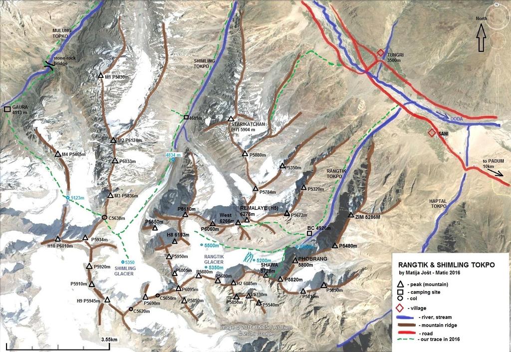
1 Haptal mountains 2016 Slovenian expedition Exploration of RANGTIK TOKPO and SHIMLNIG TOKPO alpine climbing potentials in Zanskar In summer 2016 Anastasija Davidova Nastja and I (Matija Jošt Matic) spent some nice time exploring and trekking in the Haptal mountains massif. Idea to travel back to beautiful Zanskar arises in 2015 when we spent nice time in Raru Mountains and Tetleh Nala. At that time we realize that mountain area southwest of the Doda river (also refer as Stod river) is very rarely visited by mountaineers and may be hiding some nice alpine climbing potentials. From mid July to beginning of September 2016 we visit Rangtik Tokpo, Shimling Tokpo and Denyai Tokpo. In this report I will cover exportation of Rangtik and Shimling Tokpo, Exploration of Denyai Tokpo is covered in separate report. Main Doda river valley (Zanskar valley) running from Darung-Drung glacier near Pensi La to southeast direction towards Padum where after confluence with Tsarap river they form Zanskar river, a tributary of the Indus river. Along the river is main Kargil Padum road witch passes villages of Akshow, Abran, Kushol, Phey, Tungri. Southwest of the Doda river is Great Himalayan range, there
2 are many valleys originate from it and converge to Zanskar. Some of them are (from north to south): Haskira Tokpo, Kange Tokpo, Hangshu Nala, Panding Tokpo, Bakarsei Tokpo, Denyai Tokpo, Mulung Tokpo, Shimling Tokpo, Rangtik Tokpo, Haptal Tokpo, Chhogo Tokpo, Gompe Tokpo. All this valleys are surrounded by many mostly unclimbed peaks. The altitude of the peaks vary from 5200 m to 6400 m. Local Ladakhi people (and early explorers) uses some of the valleys for connection with Kisthwar in the south. Main trekking passes are: Muni La at the head of Haptal Tokpo, Umasi La at the head of Mulung Tokpo and Hagshu La at the head of Hangshu Nala. Most popular for climbing is Hangshu Nala with famous and beautiful peak Hagshu (6515 m). All the other valleys get very little or no attention from climbers, but popularity of the area is increasing in recent years. The main reason for that are two reports. In 2009 Spanish climber Sergi Ricart who spent several months in Ladakh and Zanskar also visit the Haptal area and report in AAJ. At that time he visited Rangtik Tokpo and Kange Tokpo. In 2012 Japanese senior expedition (leader Kimikazu Sakamoto) explore in the area. They report about their activity and also made better mapping of the area and identification of many peaks. So the best map of the area so far is Sakamoto map, he marked peaks with H1, H2 etc for Haptal Tokpo, and M1, M2, etc for peaks in Mulung Tokpo. With cooperation of local agency Skitpo Travel ( we first visit Rangtik Tokpo, where we spent some 20 days climbing and exploring. Skitpo Travel employs local people mostly from Tungri village and they provide us really with excellent service and very nice cultural experience as we were introduced well to their traditional way of life. First we made acclimatization climb on south slopes of Remalaye (H5, 6278 m) and we reached prominent point on west ridge of the mountain (Remalaye west, GPS: 6266 m, 33 28'50" North, 76 43'33" East). It was obvious that main summit is higher and also some ridge gendarmes leading to the main summit looked higher than our standing point. After this weather turn to very unstable with mostly more than one shower per day. We made some attempts on Phobrang and P6193 m (aka H8). Every time we were forced to retreat quite low from their faces. Despite not so good weather we managed to climb route Rolling Stones to the summit of Shawa Kangri. First ascent of peak was made 16 th August 2008 by Spanish climbers Luc Pellissa and Sergi Ricart via approximately 500 m high route Rolling Stones and graded it D+, ice 65, rock UIAA V+. They also named peak itself. The summit block looks like horn so they named it Shawa (Shawa means horn in Ladakhi language). Climbing was on nice ice and very good quality rock. It took us 8 hours roundtrip from our BC (GPS: 33 28'30" North, 76 45'13 East, 4926 m) to repeat this real nice alpine route. At summit we did GPS reading so the coordinates of Shawa Kangri are: 5728 m, 33 27'46 North, 76 44'07" East. Because no improvement in weather we evacuated our BC and went for trekking. We stated up the Shimling Tokpo, treked almost to the very head of Shimling glacier, then turned back and passed 5638 m col to Mulung Tokpo and ended it at Zunkul Gompa. After some days in Tungri village we did also trek to Denyai Tokpo but I will report that in separate report. In first days of September weather improves and we hiked again in Rangtik Tokpo. We made strong attempt on P6193 m (aka H8). We climb to small col (between P6110 m and P6193 m) from the east and then move to icy north flanks but we stop at some 6100 m and returned safe back down to our high cam at Rangtik glacier. During our trip we see and identify some very attractive peaks. Almost all peaks we see are unclimbed and unnamed but they provided great potential for alpine style ascents of all sorts and of all grades.
3
, L is P5480 m, F is Phobrang (5800 m), M is P5820 m, G is Shawa Kangri (GPS: 5728 m, 33 27'46 North, 76 44'07\" East), H is P6085 m (aka H2), E is Remalaye (H5, 6278 m), A is")
4 View of Rangtik and Shimling mountains from north-east from slopes above Tungri village. V is Zim (5286 m), L is P5480 m, F is Phobrang (5800 m), M is P5820 m, G is Shawa Kangri (GPS: 5728 m, 33 27'46 North, 76 44'07" East), H is P6085 m (aka H2), E is Remalaye (H5, 6278 m), A is P6193 m (aka H8), B is P6110 m, S is P5880 m, P is Starikatchan (aka H7, 5904 m) and R is P6124 m (aka M2).
, G is Shawa Kangri (GPS: 5728 m, 33 27'46 North, 76 44'07\" East), H is P6085 m (aka H2), I is P5680 m, J is P6095 m and K is P6005 m.")
5 Base camp site in Rangtik Tokpo (GPS: 33 28'30" North, 76 45'13 East, 4926 m) and mountains on the south side of Rangtik glacier. F is Phobrang (5800 m), G is Shawa Kangri (GPS: 5728 m, 33 27'46 North, 76 44'07" East), H is P6085 m (aka H2), I is P5680 m, J is P6095 m and K is P6005 m. Route of first ascent of Shawa Kangri is marked in red. First ascent of peak was made 16 th August 2008 by Spanish climbers Luc Pellissa and Sergi Ricart. They named their approximately 500 m high route Rolling Stones and graded it D+, ice 65, rock UIAA V+. They also named peak itself. The summit block looks like horn so they named it Shawa (Shawa means horn in Ladakhi language).
, M is P5820 m, G is Shawa Kangri (GPS: 5728 m, 33 27'46 North,")
6 Mountains on the south side of Rangtik glacier as seen from upper Rangtik Glacier. L is P5480 m, F is Phobrang (5800 m), M is P5820 m, G is Shawa Kangri (GPS: 5728 m, 33 27'46 North, 76 44'07" East).
, H is P6085 m (aka H2), I is P5680 m, O is P5850 m, J is P6095 m, K is")
7 Mountains on the south and west side of Rangtik glacier as seen from upper Rangtik Glacier. G is Shawa Kangri (GPS: 33 27'46 North, 76 44'07" East, 5728 m), H is P6085 m (aka H2), I is P5680 m, O is P5850 m, J is P6095 m, K is P6005 m, N is P5950 m and A is P6193 m (aka H8).
, B is P6110 m, C is P6060 m, D is Remalaye west (GPS: 33 28'50\" North, 76 43'33\" East, 6266 m), E is Remalaye main (aka H5, 6278 m).")
8 Mountains on the west and north side of Rangtik glacier as seen from Shawa Kangri summit. A is P6193 m (aka H8), B is P6110 m, C is P6060 m, D is Remalaye west (GPS: 33 28'50" North, 76 43'33" East, 6266 m), E is Remalaye main (aka H5, 6278 m). Red line indicates line of first ascent via south slopes by Anastasija Davidova - Nastja and Matija Jošt - Matic in 2016.

9 East face (in shadow) and southeast face of P6193 m (aka H8) marked with A as seen from the summit of Ramalaye west. N is P5950 m and B is western part of P6110 m
, D is Remalaye west (GPS: 6166 m, 33 28'50\" North,")

10 View of Remalaye from town of Padum. E is Remalaye main (H5, 6278 m), D is Remalaye west (GPS: 6166 m, 33 28'50" North, 76 43'33" East). Red line indicates line of first ascent by Anastasija Davidova - Nastja and Matija Jošt - Matic in View down the Shimling glacier towards south west face of Starikatchan (H7, 5904 m) marked with P.


11 West face of Starikatchan (H7, 5904 m) marked with P as seen from main Kargil Padum road. Photo was taken near Phe village. East face of Starikatchan (H7, 5904 m), highest point of the mountain is marked with P. Photo was taken from ridge just east of the mountain (GPS: 5227 m, 33 30'40" North, 76 44'25" East).

12 P6124 (aka M2) marked with R as seen from lower Shimling Tokpo.

13 E is Remalaye main (H5, 6278 m), D is Remalaye west (GPS: 33 28'50" North, 76 43'33" East, 6266 m), B is P6110 m. Photo showing west and north slopes of the peaks. Photo is taken from viewpoint above campsite in lower Shimling Tokpo.
, N is P5950 m, K is P6005 m, J is P6095 m.")
14 Panoramic view of the peaks on the east side of the upper Shimling glacier showing their west slopes. B is P6110 m, A is P6193 m (aka H8), N is P5950 m, K is P6005 m, J is P6095 m. On the far right of the photo is col C5650 m.

15 Panoramic view of the peaks on the west side of the upper Shimling glacier showing their east slopes. X is P5945 m, W is 5910 m, Z is P5920 m. On the far left of the photo is col C5620 m.
, N is P5950 m, K is P6005 m, J is P6095 m.")
16 Panoramic view of the peaks on the east side of the upper Shimling glacier showing their west and north slopes. B is P6110 m, A is P6193 m (aka H8), N is P5950 m, K is P6005 m, J is P6095 m. Photo was taken from the pass connecting Shimling Tokpo with Mulung Tokpo (GPS: 33 28'58" North, 76 40'32" East, 5638 m). On the far right of the photo is col C5650 m.
17 Panoramic view towards east from the viewpoint at glacier junction in Mulung Tokpo (GPS: 33 29'25" North, 76 39'42" East, 5123 m). R is P6124 (aka M2), T is P6033 m, U is P5836 (aka M3) and A is P6193 m (aka H8). Just in front and right of P6193 m on very right edge of the photo is pass connecting Shimling Tokpo with Mulung Tokpo (GPS: 33 28'58" North, 76 40'32" East, 5638 m).
 marked with")
18 North slopes of P6010 (aka H10) marked with Y.
STOK KANGRI 5490M STOK KANGRI TREK Aug 03-15, 2019
 STOK KANGRI 5490M STOK KANGRI TREK Aug 03-15, 2019 STOK KANGRI TREK: INTRODUCTION One of the most popular trekking peaks in the Indian Himalayas and on the planet, the proximity to Leh (the capital of
Stok Kangri Peak (6120m) 2 to 16 September 2018 Explore the hidden kingdom of Ladakh with Stok Kangri Peak
 2 to 16 September 2018 Explore the hidden kingdom of Ladakh with Stok Kangri Peak") Stok Kangri Peak (6120m) 2 to 16 September 2018 Explore the hidden kingdom of Ladakh with Stok Kangri Peak Stok Kangri is a perfect objective for fit trekkers without climbing experience, and is one of
Stok Kangri Peak (6120m) 2 to 16 September 2018 Explore the hidden kingdom of Ladakh with Stok Kangri Peak Stok Kangri is a perfect objective for fit trekkers without climbing experience, and is one of
From Rassa to Sumur..a journey of exploration and climbing.
 From Rassa to Sumur..a journey of exploration and climbing. In 2001, a glimpse of Rassa glacier, during our expedition to Arganglas valley indicated great opportunity for exploration and climbing. In July
The height of Machu is 6630m on the Swiss map, 6612m on the Russian map and 6603m on Google Earth.
 Hispar Expedition 2017 Expedition Final Report MEF reference: 17-42 Country and region visited: Pakistan, Hunza Valley, Karakoram. Objective To make the first ascent of Machu (6630m) by the southwest and
Stok Kangri Trek 2013
 Stok Kangri Trek 2013 Area: Ladakh Duration: 11 Days Altitude: 6153 mts Grade: Moderate to Challenging Towering at an impressive 6153 m, Stok Kangri is a serious challenge. Although at such an impressive
PERUVIAN ANDES ADVENTURES. ARTESONRAJU CLIMB 6025m (19767 ft) Grade: D+ to TD/ Technical. Routes: The two routes to climb Artesonraju are;
 Grade: D+ to TD/ Technical. Routes: The two routes to climb Artesonraju are;") PERUVIAN ANDES ADVENTURES ARTESONRAJU CLIMB 6025m (19767 ft) Grade: D+ to TD/ Technical Routes: The two routes to climb Artesonraju are; *Via the Paron Valley South East Ridge 5 days (option for 6 with
PERUVIAN ANDES ADVENTURES ARTESONRAJU CLIMB 6025m (19767 ft) Grade: D+ to TD/ Technical Routes: The two routes to climb Artesonraju are; *Via the Paron Valley South East Ridge 5 days (option for 6 with
ASIAN ALPINE E NEWS. Issue No. 27 June 2018
 ASIAN ALPINE E NEWS Issue No. 27 June 2018 Extract published in last AAE25 with permission from Roli Books from the book "Legendary Maps from the Himalayan Club", edited by Harish Kapadia. Available from
Markha Valley Trek 2016
 Markha Valley Trek 2016 Area: Ladakh Himalayas Duration: 11 Days Max. Altitude: 5150 mts/16895 ft) Grade: Moderate to challenging Season: Mid June - October The Markha Valley Trek is certainly one of the
Muchu Chhish Expedition 2014
 Muchu Chhish Expedition 2014 MEF reference 14/21 Country and region visited: Pakistan, Batura Muztagh, Karakoram. Objectives: To make the first ascent of Muchu Chhish 7453m by the south and west ridges.
Stok Kangri, (6121ms) Ladakh, Indian Himalayas
 Ladakh, Indian Himalayas") Stok Kangri, (6121ms) Ladakh, Indian Himalayas This outstanding trek to the summit of India s highest mountain Stok Kangri, (6,121m/20,082ft) is the perfect challenge for trekkers, who want to summit an
Stok Kangri, (6121ms) Ladakh, Indian Himalayas This outstanding trek to the summit of India s highest mountain Stok Kangri, (6,121m/20,082ft) is the perfect challenge for trekkers, who want to summit an
6 DAYS MACHAME ROUTES ON KILIMANJARO
 6 DAYS MACHAME ROUTES ON KILIMANJARO Day 1: Moshi Machame camp In the morning, we depart from our base hotel at approximately 8:00 AM for the Machame village where you begin the trek. From the park entrance
! Kilimanjaro Expedition
 ! Kilimanjaro Expedition Tanzania 2016 Climb Only: $4,350 (land costs) Feb 4-12; June 12-20; July 10-18; Aug 6-14; Sept 11-19; Dec 4-12 2016 Climb & Safari: $5,850 (land costs) Feb 4-15; June 12-23; July
INDIA HIMALAYA STOK KANGRI ASCENT 21 DAYS
 INDIA HIMALAYA STOK KANGRI ASCENT 21 DAYS No words can describe the overwhelming experience of being among the world s greatest mountains you really have to be here! The enormous glaciated peaks, challenging
2015 Temasa Nala Expedition
 1 2015 Temasa Nala Expedition A report on the exploration and unclimbed peaks of the upper Korlomshe Tokpo region of Zanskar in the Indian Himalaya 20 th August 20 th September 2015 Derek R Buckle (18
2017 Sumur Valley Expedition*
 1 2017 Sumur Valley Expedition* A report on the exploration and unclimbed peaks of the Sumur Glacier in the Indian East Karakoram 31st August 7th October 2017 Derek R Buckle (18 Hillfield Road, Redhill,
REPORT. MANASLU EXPEDITION (8163 m) Track NE (traditional)
 Track NE (traditional)") REPORT MANASLU EXPEDITION (8163 m) Track NE (traditional) Contents Expedition passport 2 Description of the route 3 Description of the expedition 4-5 Scheme of the route 6 Map of the route 7 Map of the
REPORT MANASLU EXPEDITION (8163 m) Track NE (traditional) Contents Expedition passport 2 Description of the route 3 Description of the expedition 4-5 Scheme of the route 6 Map of the route 7 Map of the
Two Peaks in the Headwaters of Karcha Nala JAC Tokai to the Indian Himalayas
 KAZUO HOSHI Two Peaks in the Headwaters of Karcha Nala JAC Tokai to the Indian Himalayas The Tokai Section of the Japanese Alpine Club (hereinafter described as JAC Tokai) conducted 11 expeditions to the
Autumn 2009 Expedition to the Kangri Garpo East Mountains, Tibet
 JAPANESE ALPINE NEWS 2015 KIMIKAZU TATSUO (TIM) SAKAMOTO INOUE Exploration The First in Ascent Kinner of and Lopchin Spiti of Feng Indian (KG-2) Himalaya 6,805m 2014 Autumn 2009 Expedition to the Kangri
GUIDE INDIA HIMALAYA STOK KANGRI ASCENT 21 DAYS SUMMER 2019
 GUIDE INDIA HIMALAYA STOK KANGRI ASCENT SUMMER 2019 21 DAYS WHERE ARE YOU GOING? INDIA HIMALAYA No words can describe the overwhelming experience of being among the world s greatest mountains you really
18 day itinerary: ACONCAGUA Normal Route 15 day trek. T r i p I t i n e r a r y
 T r i p I t i n e r a r y HIGHLIGHTS Summit the highest mountain in South America, and the second highest of the Seven Summits Breath-taking views of the Andes Three days set aside for the summit attempt
PERUVIAN ANDES ADVENTURES. TOCLLARAJU CLIMB or ISHINCA + TOCLLARAJU CLIMBING. Tocllaraju 4 Days Ishinca + Tocllaraju 5 or 6 days
 PERUVIAN ANDES ADVENTURES TOCLLARAJU CLIMB or ISHINCA + TOCLLARAJU CLIMBING Tocllaraju 4 Days Ishinca + Tocllaraju 5 or 6 days PEAKS Tocllaraju: 6034m (19797 ft) Grade: D / Hard / Some steep & technical
CHALLENGE OVERVIEW. ACCOMMODATION. You will be accommodated in friendly, simple hotels and tents whilst on the mountain.
 CHALLENGE OVERVIEW Mount Kilimanjaro is one of the seven Natural Wonders of the World and for many people, standing on its summit is a life-long ambition. The snow-capped peak was first reached by German
LADAKH: MARKHA VALLEY & DZO JONGO
 LADAKH: MARKHA VALLEY & DZO JONGO This information should answer some of your questions about the trip and give you a better idea of what we do day-to-day. It doesn t hope to answer everything. If you
Island Peak (Imja Tse )
") Popularly known as Imja Tse, Island Peak is the most climbing peaks in Nepal. It appears as an island of the icy sea while viewing form Dingbuche and on close inception, it exposes itself to be the most
Popularly known as Imja Tse, Island Peak is the most climbing peaks in Nepal. It appears as an island of the icy sea while viewing form Dingbuche and on close inception, it exposes itself to be the most
The Langtang Valley Trek December 2014
 The Langtang Valley Trek December 2014 1 TREK THE LANGTANG VALLEY IN NEPAL ( Dec 2014) Kathmandu to Kathmandu) Amongst the three major trekking areas in Nepal, namely, Everest, Annapurna and Langtang,
Indian Mountaineering Foundation. Highlights of Festival. announces
 Indian Mountaineering Foundation announces Mountaineering Festival 2018-19 Himachal Pradesh 23 Jul- 12 Aug 2018 Sikkim 15 Oct- 03 Nov 2018 Uttarakhand 20 May-8 Jun 2019 Ladakh (J&K) 22 Jul- 11 Aug 2019
Future Climbing Park Nyainbo Yuze in Qinghai
 JAPANESE ALPINE NEWS 2014 HENGDUANG MAOUNTAINS CLUB Future Climbing Park Nyainbo Yuze in Qinghai A GUIDE TO MOUNTAINEERING IN CHINA (jointly edited and published by the China Mountaineering Association
Machame 7 Days 6 Nights
 Machame 7 Days 6 Nights If Marangu is the Coca Cola route, then the Machame Route is the Whiskey route. It is the second most popular and one of the most scenic routes on the mountain. All climbers sleep
Trek2Kili P.O. Box 2112 Moshi TZ Whatsapp
 Trek2Kili P.O. Box 2112 Moshi TZ Whatsapp +255 673 360 trek2kili@gmail.com MT. KILIMANJARO SHIRA 8 DAY 7 NIGHT TREK Very similar to Lemosho route, however it starts at 3,600 meters and is therefore not
PERUVIAN ANDES ADVENTURES. EXPEDITION Climbing Alpamayo & Huascaran. PEAKS: Maparaju 5350m Alpamayo 5947m Huascaran Sur 6768m
 PERUVIAN ANDES ADVENTURES EXPEDITION Climbing Alpamayo & Huascaran PEAKS: Maparaju 5350m Alpamayo 5947m Huascaran Sur 6768m 23 days Huaraz to Huaraz Grade: Technical, physically demanding This is a comprehensive
KANG YATSE-II KANG YATSE-II TREK Jul 23 - Aug 04 &Aug 15-27, 2019
 KANG YATSE-II KANG YATSE-II TREK Jul 23 - Aug 04 &Aug 15-27, 2019 KANG YATSE-II: INTRODUCTION The Western Summit of the Kang Yatse Peak, or Kang Yatse II, offers the perfect challenge for folks looking
THE THREE PEAKS OF TANZANIA
 THE THREE PEAKS OF TANZANIA Longido, Mt Meru, and Kilimanjaro in 13 days Day 1 Arrival Longido approx 10kms trekking FBA can arrange your flights to Nairobi or Kilimanjaro. If booking your own flights,
 +91-8048756753 Explore Himalayas http://www.ladakhvisit.com/ Since 1993 we are engaged in providing tour & travel services as Ladakh Tour Packages, Mountain Biking Tour, Markha Valley Trek, Markha Valley
trek Stok Kangri at a glance trip highlights
 Stok Kangri actionchallenge on stands magnificently at 6153m, towering over the Stok range in the Indian Himalayas. This is our latest opportunity to take on a new trekking peak in high altitude with Action
Getaway Goddess - Ladakh
 Your Itinerary in Brief Day Description Meals Hotel DAY 1 Arrival transfer from airport to hotel in Leh (NAC Private Vehicle). D Hotel Kanika Himalayan View Or Similar ( Leh ) DAY 2 Visit Shanti Stupa,
MOUNT SIDLEY EXPEDITION 2019
 MOUNT SIDLEY EXPEDITION 2019 TRIP NOTES MOUNT SIDLEY 2019 Expedition Notes All material Copyright Adventure Consultants Ltd 2018/2019 During the southern summer of 2018/2019, Adventure Consultants will
Junglam Trek. Day 02: Leh Shey Thiksey On this day you will go a sightseeing trip to some ancient monasteries in this area.
 Junglam Trek The trek starts from Hemis monastery (one of the richest monastery in Ladakh). It enters in famous Markha valley and Zanskar via Junglam, which is open only for a month. In summer this route
Oman Trek Trek the dramatic and beautiful scenery of Oman
 Oman Trek Trek the dramatic and beautiful scenery of Oman Discover Oman on this breath taking 5 day challenge. The mountain ranges and deserts of Oman offer spectacular trekking, and enables you to experience
TREK THE ROCKIES ABOUT THE CHALLENGE TREK THE ROCKIES FOR HIGHLAND HOSPICE CANADA TREK DEMANDING
 TREK THE ROCKIES CANADA TREK DEMANDING ABOUT THE CHALLENGE The Canadian Rockies are justifiably world-famous for their magnificent scenery: the combination of impressive, jagged mountains, bright turquoise
Summer Haute Route Trek 2018 TRIP NOTES
 Summer Haute Route Trek 2018 TRIP NOTES Summer Haute Route Trek 9 days (7 days trekking, 2 travel days) 2018 Trip Notes All material Copyright Adventure Consultants Ltd 2017/2018 This alpine classic follows
MT KILIMANJARO TREK- LEMOSHO ROUTE
 #Trekking MT KILIMANJARO TREK- LEMOSHO ROUTE 10 Days 9 Nights Overview Take the challenging and less-travelled Lemosho route up to the highest peak in Africa, considered by many to be the most beautiful
KATKAR NALA EXPEDITION INDIA
 KATKAR NALA EXPEDITION INDIA 2015 CHISHOLM, NICOLL & PARTNERS EXPEDITION REPORT OVERVIEW The aim of our expedition was to complete first ascents of peaks at around 5,900m in the Greater Himalaya, in the
KUSHILAND Expeditions & Tour Safaris Ltd
 KILIMANJARO TREK MACHAME ROUTE TOUR CODE KMC 02 7 DAYS MACHAME ROUTE Kilimanjaro s Machame Route, often referred to as the Whiskey route, is more scenic and is longer than Marangu. The minimum duration
During trekking and climbing period, trail starts From Katmandu to Syabrubesi by local Bus or other private transportation via Dhunche.
 Yala Peak Climbing Yala Peak Climbing is one of Nepal's easier trekking peaks among whole peaks in Nepal. This peak climbing lies in northern part of Kathmandu valley and located in the Langtang trekking
ON OCTOBER 3, 1982 Dana
 Gongga Shan- Minya Konka Revisited DOUGLAS KELLEY and JOSEPH E. MURPHY ON OCTOBER 3, 1982 Dana Coffield and Douglas Kelley reached the summit of Gongga Shan, a 24,891-foot peak in western Sichuan province
MT FRIENDSHIP TREK. A Mountaineering Expedition in Pir Panjal Range of Himalayas!
 MT FRIENDSHIP TREK A Mountaineering Expedition in Pir Panjal Range of Himalayas! With a view to promote Youth into the less explored field of Mountaineering or Mountain Hiking, Invincible the youth run
Ladakh Trek Trek Little Tibet amidst India s finest mountains
 Ladakh Trek Trek Little Tibet amidst India s finest mountains Travel to India and experience this stunning 5 day trek passing through the multi-coloured mountain range ornamented with villages, monasteries,
PREPARED BY LADAKHTRIPMAKER EXPLORE AND ENJOY LADAKH WITH US...
 PREPARED BY LADAKHTRIPMAKER EXPLORE AND ENJOY LADAKH WITH US... Ladakh, one of the few strongholds of Tibetan Buddhist life, culture and religion, lies cradled in the heart of the Great North-Western Himalaya.
Mount Kilimanjaro Climbing via Marangu Route 6 day-itinerary
 Mount Kilimanjaro Climbing via Marangu Route 6 day-itinerary (For the 5-day route, simply exclude the additional acclimatisation day at Horombo hut - day 3 on the itinerary below.) Total hiking distance:
Adventure Travel Trip Itinerary
 s of trip: August 20 - September 4, 2019 Aug 20 (Tues) Travel to Geneva, Switzerland 1 Aug 21 (Wed) Arrival in Geneva Please plan to arrive before 2 p.m. local time, to allow enough time to get through
VINSON MASSIF EXPEDITIONS 2017/2018 TRIP NOTES
 VINSON MASSIF EXPEDITIONS 2017/2018 TRIP NOTES VINSON MASSIF 2017/2018 Expedition Notes All material Copyright Adventure Consultants Ltd 2017/2018 During the southern summer of 2017/2018, Adventure Consultants
Mt. Gunnbjörn, Dome and Cone (IMG66)
") 2018 The Peaks of Greenland: Mt. Gunnbjörn, Dome and Cone (IMG66) Ski ascent of the highest peaks in the Greenland Arctic - Expedition manual - Content overview Expedition overview Further information
2018 The Peaks of Greenland: Mt. Gunnbjörn, Dome and Cone (IMG66) Ski ascent of the highest peaks in the Greenland Arctic - Expedition manual - Content overview Expedition overview Further information
Aconcagua Leadership and Guide Training Course
 Aconcagua Leadership and Guide Training Course Cerro Aconcagua is located in the central Andes of Argentina near the border with Chile. At 22,841ft (6,962m), it is one of the seven summits and the only
South Simvu: Kanchenjunga s last kept Secret
 South Simvu: Kanchenjunga s last kept Secret Text & Photographs: Anindya Mukherjee Maps, if caviare 1 to the general, are, as Louis Stevenson has insisted, very suggestive to persons with proper imagination.
VINSON TRIP INFORMATION PACKET TRIP INFORMATION PRICE INCLUDES:
 VINSON TRIP INFORMATION PACKET TRIP INFORMATION Location: Ellsworth Range, Antarctica Days: 21 Summit Height: 16,050 ft. Trip begins in Punta Arenas, Chile Airport (PUQ) PRICE INCLUDES: Mountain Professionals
Day by Day Itinerary: Mera Peak - 20 days. $ per person
 Mera Peak - 20 days Go on 20 days trip for $ per person Mera Peak (6,654 m) is the highest permitted trekking peak in Nepal. It stands to the south of Everest and dominates the watershed between the heavily
Mt. Gunnbjörn, Dome and Cone (IMG66)
") 2015 The Peaks of Greenland: Mt. Gunnbjörn, Dome and Cone (IMG66) Ski ascent of the highest peaks in the Greenland Arctic - Expedition manual - Content overview Expedition overview Further information
2015 The Peaks of Greenland: Mt. Gunnbjörn, Dome and Cone (IMG66) Ski ascent of the highest peaks in the Greenland Arctic - Expedition manual - Content overview Expedition overview Further information
RUSSIA. Elbrus. I
 RUSSIA Elbrus RUSSIA Elbrus Mount Elbrus is the highest peak in Russia and Europe and although many mountaineers visit the area to climb the mountain, there are also many other attractions here. On the
Non-motorized Trail Plan & Proposal. August 8, 2014
 Town of Star Valley Ranch, Wyoming and the Star Valley Ranch Association in partnership with the USDA Forest Service, Bridger-Teton National Forest, Greys River Ranger District Non-motorized Trail Plan
2015 Cordillera Central Mountains of Peru, Sullcon and Paca climbing Expedition
 Introduction The Cordillera Central (also called the Huarochiri or Pariacacca Mountains) is the closest Andean Mountain Range to Lima the Capital of Peru (see Map 1). It is located approximately 80 to
Global Adventure Trekking A best holiday maker
 Everest Base Camp trekking Everest Base Camp trekking goes through Sherpa village, Trans Himalayan trade centre Namche Bazar into the Alpine climatic zone to Kalapather and Everest base camp in Khumbu
Mountaineering in the Cordillera Blanca, Peru
 Mountaineering in the Cordillera Blanca, Peru ANUMC Expedition Proposal June-July 2019 Introduction: The Andes of South America form the world s highest mountain range outside of Asia and, as the longest
The Cirque. Everything you need to know about climbing the Lotus Flower Tower. Southeast Face 2000 feet 19 pitches up 10 rappels down 5.
 The Cirque Cirque of the Unclimbables, Northwest Territories, Canada Created: Sept 4, 2011 Everything you need to know about climbing the Lotus Flower Tower Southeast Face 2000 feet 19 pitches up 10 rappels
DALHOUSIE WINTER TREKKING EXPEDITION
 DALHOUSIE WINTER TREKKING EXPEDITION Winter Himalayan Trekking Expedition 2016-17 To groom the youngsters in the field of adventures and environmental awareness, Invincible NGO presents the most interactive
Japanese Alpinists in the Himalaya
 Japanese Alpinists in the Himalaya I. THE FIRST ASCENT OF CHOGOLISA P r o f. T ak eo K uw abara T h e A c a d e m ic A l p i n e C l u b o f K y o t o went on an expedition to Chogolisa (7.654 m.; 25,110
MT. KILIMANJARO SHIRA ROUTE 8 days
 MT. KILIMANJARO SHIRA ROUTE 8 days Activities: Trekking Difficulty: Moderate to Adventurous Max Elevation: 5,895m/ 19,340 ft at summit Meal: Full board on trek Accommodation: Hotel in Moshi/ tent on trek
S2Kilimanjaro 8220 Barningham Road Richmond VA / /
 S2Kilimanjaro 8220 Barningham Road Richmond VA 23235 / 505.670.1441 Adventures @S2Mountaineering.com / www.s2mountaineering.com Lemosho Route The Lemosho Route is a remote, unspoiled and very beautiful
L U N C H C R E E K T R A I L GLACIER NATIONAL PARK
 D I R T I N M Y S H O E S L U N C H C R E E K T R A I L GLACIER NATIONAL PARK Lunch Creek "Secret" Hike This short hike on the Lunch Creek Trail will knock your socks off! It's the perfect mix of length,
CLIMBING A NAMELESS PEAK AND SHORT SURVEYS AROUND MUSTANG TO THE NORTHWEST
 CLIMBING A NAMELESS PEAK AND SHORT SURVEYS AROUND MUSTANG TO THE NORTHWEST The summer 2001 in Mustang was about to end when we placed training camps at a point of 4070m and 4780m (both GPS height) en route
LANGTANG, GANJA LA & YALA PEAK
 COMMUNITY ACTION TREKS LTD Stewart Hill Cottage, Near Hesket Newmarket, Wigton, Cumbria, CA7 8HX Tel: 01768 484842 Email: info@catreks.com Web: www.catreks.com LANGTANG, GANJA LA & YALA PEAK Grade: Strenuous
EXPEDITIONS & NOTES. Trekkers approaching Saraswati col at the head of Mana glacier
 Trekkers approaching Saraswati col at the head of Mana glacier 342 13 In Search of the Elusive Arwa Col Avilash Bisht We were all exhilarated. We could see Kalindi pass right across and a host of peaks
Everest Advanced Base Camp Trek
 We call this the Highest trek in the world, 15 days culture and wilderness on the Tibetan Plateau. With an average altitude in excess of 3500m, Tibet can truly be described as the roof of the world. Lying
ILLAMPU (6368M) TECHNICAL CLIMBING
 TECHNICAL CLIMBING") ILLAMPU (6368M) Illampu s south face TECHNICAL CLIMBING Illampu (6356m) is the northern most mountain in the Cordillera Real, and according to indigenous folklore is considered the King of the mountains.
ILLAMPU (6368M) Illampu s south face TECHNICAL CLIMBING Illampu (6356m) is the northern most mountain in the Cordillera Real, and according to indigenous folklore is considered the King of the mountains.
KASHMIR GREAT LAKES THE GREAT LAKES OF KASHMIR TREK Jun 29 - Jul 09 & Jul 12-23, 2019
 KASHMIR GREAT LAKES THE GREAT LAKES OF KASHMIR TREK Jun 29 - Jul 09 & Jul 12-23, 2019 THE GREAT LAKES TREK: INTRODUCTION The Great Lakes of Kashmir trek is set in an almost heavenly arena of high mountain
INFORMATION PACK ABOUT CAMP QUALITY TREK 4 KIDS. MT KILIMANJARO
 INFORMATION PACK ABOUT CAMP QUALITY TREK 4 KIDS. MT KILIMANJARO Camp Quality challenge events have seen supporters from all around Australia walk the Kokoda Track and crawl through the Jungles of Borneo
Mt Kenya Sirimon Chogoria Route 8 day Mt Kenya trek
 10 Oswald Road Llandudno Junction Conwy LL31 9EP Telephone: 01492 588069 Email: info@adventurousewe.co.uk www.adventurousewe.co.uk Mt Kenya Sirimon Chogoria Route 8 day Mt Kenya trek Why this itinerary?
Base Camp Trek. Trek dates October to early December and end of February to May
 Base Camp Trek This special version of the trek to Everest Base Camp is designed for anyone who is very fit and has some trekking experience. The route to base camp is the same as the longer trek but with
Mt. Rainier Three-Day Muir Climb
 Mt. Rainier Three-Day Muir Climb Details below provided by AAI Elevation: 14,411 feet Guide Service: Alpine Ascents International (AAI) Fundraising minimum: $5,000.00 USD Muir Three-Day Overview Our three-day
MIYAR VALLEY AND THE KANG LA
 A challenging trek over the rarely crossed Kang La to Zanskar Glacier trekking in the Indian High Himalaya Rarely visited villages and spectacular mountain scenery From Manali to Zanskar through the Miyar
Mount Kilimanjaro Climbing via Rongai Route 8 day-itinerary
 Mount Kilimanjaro Climbing via Rongai Route 8 day-itinerary Total hiking distance: Approximately 70 kms The Rongai route ascends Kilimanjaro from the north-eastern side of the mountain, along the border
LADAKH - MARKHA VALLEY AND THREE PASSES
 COMMUNITY ACTION TREKS LTD Tel: 01 Email: info@catreks.com Web: www.catreks.com LADAKH - MARKHA VALLEY AND THREE PASSES Grade: Demanding Land-only duration: 18 days Delhi - Delhi Trekking days: 10 Maximum
TREKKING IN THE ALPS HILARY SHARP SUMMER HIKING AND WINTER SNOWSHOEING
 TREKKING IN THE ALPS HILARY SHARP SUMMER HIKING AND WINTER SNOWSHOEING www.trekkinginthealps.com info@trekkinginthealps.com NO hidden costs. Small groups guaranteed. Expert guiding All levels catered for.
Grizzly Peak A - East Ridge July 15, 2012
 Grizzly Peak A - East Ridge July 15, 2012 Difficulty: Difficult Class 2/Class 3 Upper Elevation: 13,995 feet Trailhead Elevation: 11,360 feet Elevation Gain: 3,000 feet Round-trip Length: 6.0 miles Trailhead:
HIKING IN THE CANADIAN ROCKIES
 HIKING IN THE CANADIAN ROCKIES Distance Time Elevation y MORAINE LAKE TRAILS THE ROCKPILE 0.8 km (0.5 mi) 20 min 30 m (98 ft) Located adjacent to the Lodge, the short interpretive trail up the Rock Pile
South Col Expeditions 1
 sujoyrdas@gmail.com 1 sujoyrdas@gmail.com 2 Map of the Annapurna Region This trek covers the route to the south base camp of Annapurna I, the tenth highest mountain in the world. This classic trek starts
Everest Base Camp Trek
 Everest Base Camp Trek TRIP FACTS Tengboche Monastery visit, Rhododendron forest (flower; March/April), superb mountain views including Everest, picturesque Sherpa settlements, visit of Kalapatthar (5545m)
GOLDEN EARS PROVINCIAL PARK
 GOLDEN EARS PROVINCIAL PARK Trail Information as of October 10 th 2015 Do not underestimate the mountainous wilderness of Golden Ears Provincial Park. The combination of rugged terrain and rapidly changing
South Col Expeditions 1
 sujoyrdas@gmail.com 1 The trek initially follows the Annapurna Circuit route but branches off north east at Koto Qupar and then enters a restricted valley bordering Tibet. It then crosses the 5300 metre
GO LADAKH! An initiation to Ladakh. What is it? 10th edition of the annual CWH group trip to the land of passes. 3 rd 11 th June 2017.
 GO LADAKH! An initiation to Ladakh What is it? 10th edition of the annual CWH group trip to the land of passes. 3 rd 11 th June 2017. What would you call a journey traversing 3 of the 5 highest motorable
Mt Kilimanjaro Machame Standard Program
 Kilimanjaro is a snow-covered mountain 19,710 feet high, and is said to be the highest mountain in Africa. Its western summit is called by the Masai the House of God. Close to the western summit there
Summit Africa. Kilimanjaro Charity Climb to support construction of. Corner Stone Children s Centre
 Summit Africa Kilimanjaro Charity Climb to support construction of Corner Stone Children s Centre 6 day Machame Route Climb In aid of the Corner Stone Children s Centre (Moshi, Tanzania) Plus : Optional
Climbing Mt. Elbrus (5642m) from the North - 9 days
 from the North - 9 days") Climbing Mt. Elbrus (5642m) from the North - 9 days Elbrus is a volcanic massif to the north of the main ridge of the Caucasus Mountains. The ascent begins from Djilysu and continues along the north slope
Climbing Mt. Elbrus (5642m) from the North - 9 days Elbrus is a volcanic massif to the north of the main ridge of the Caucasus Mountains. The ascent begins from Djilysu and continues along the north slope
PARANG LA 5490M PARANG LA T REK July 26-Aug 11, 2019
 PARANG LA PARANG LA TREK July 26-Aug 11, 2019 PARANG LA: INTRODUCTION The Parang La trail follows the traditional trade route between the people of Spiti, Changthang and Tibet. It begins after the high-altitude
STEVE PRESCOTT FOUNDATION - Mt. Kilimanjaro Challenge
 STEVE PRESCOTT FOUNDATION - Mt. Kilimanjaro Challenge MACHAME ROUTE (DURATION: 8 DAYS including Crater Camp) ABOUT THE ROUTE: Many say this is the most beautiful route up Kilimanjaro; your efforts will
In 2003 the Third Koksil Glacerier was visited by Bernard Vaucher and his Pakistan friend Ishaq Ali. They reached the Peak 5,717 (Jacky Chhish)
") JAPANESE ALPINE NEWS 2012 TATSUO JANUSZ (TIM) MAJER INOUE The First Koksil Ascent Valley of Lopchin Ghujerab Feng Mountains (KG-2) 6,805m Autumn 2009 Exploration Expedition 2011 to Northern Kangri Karakoram,
JAPANESE ALPINE NEWS 2012 TATSUO JANUSZ (TIM) MAJER INOUE The First Koksil Ascent Valley of Lopchin Ghujerab Feng Mountains (KG-2) 6,805m Autumn 2009 Exploration Expedition 2011 to Northern Kangri Karakoram,
ASIAN ALPINE E NEWS. Issue No.35, September 2018
 ASIAN ALPINE E NEWS Issue No.35, September 2018 Unexplored Mekong Headwaters: Sunshine Glacier no 3 and largest of the Glaciers showing here the upper Neve portion centre top, our campsite was under the
The Summits of Canada Expedition Information and Education Summary
 The Summits of Expedition Information and Education Summary A historic Canadian adventure, the Summits of Expedition, will take place in 2006 to put the first Canadian Team on the highest point of s thirteen
Part I. Gankar Punsum
 TAMOTSU TATSUO (TIM) NAKAMURA INOUE The First Hightlights Ascent of on Lopchin the Eastern Feng Himalaya (KG-2) 6,805m Autumn Gankar 2009 Punsum, Expedition Namcha to the Kangri Barwa and Garpo Gyala East
Skiing and Snowshoes on Un-groomed Fernan Saddle Terrain
 Skiing and Snowshoes on Un-groomed Fernan Saddle Terrain Three ski or snowshoe routes are available from the Fernan Saddle Parking Lot which either do not cover routes ordinarily groomed for snow machine
Kit Carson-Challenger Ridge Trail Project Annual Performance Report-2014 October 22, 2014
 1 Kit Carson-Challenger Ridge Trail Project Annual Performance Report-2014 October 22, 2014 Willow Lake and Kit Carson Peak 2 SUMMARY The Rocky Mountain Field Institute began Phase 1 of a multi-phase,