ASIAN ALPINE E NEWS. Issue No.35, September 2018
|
|
|
- Ariel Jefferson
- 5 years ago
- Views:
Transcription
1 ASIAN ALPINE E NEWS Issue No.35, September 2018 Unexplored Mekong Headwaters: Sunshine Glacier no 3 and largest of the Glaciers showing here the upper Neve portion centre top, our campsite was under the rock peak centre picture, the glacier heading to right hand side of the picture arrives just out of picture at Facile Col. This view from 5794m. CONTENTS TAMOTSU (TOM) NAKAMURA Map of the upper Mekong River Page 2 ~ 3 The Source and Mountains in the headwaters NATHAN DAHLBERG A trip to the Mountains of South Qinghai Yushu Page 4 ~ 27 Mountain systems of the area between the geographical triangle Page 28 ~ 42 - Yushu to Zhidoi to Zadoi in detail - 1

2 TAMOTSU (TOM) NAKAMURA Map of the Source of Mekong River 1
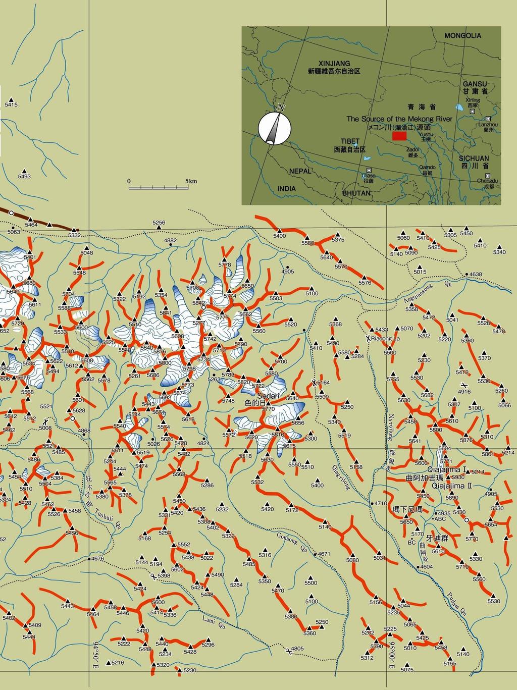
3 2
4 NATHAN DAHLBERG A trip to the Mountains of South Qinghai Yushu 14 months of planning saw me landing in Yushu airport in Qinghai China at 3800m to meet my companions Ben and Jos Hoetjes who had ridden by bike almost a 1000 km's from Xining over 10 days for acclimatization. The mission was simple a lightweight attempt on what we believe after much research to be the highest mountains on this part of the Qinghai Tibet Plateau, the glaciated peaks surrounding point 5875m. The whole project was initiated, after reading the final lines from the article Qiajajima, first ascent American Alpine Club Journal 2005, stating: Sedari (5,770m) and 5,700m 5,800m peaks ranging to the west, where glaciers are most developed. This massif remains unvisited. No photographs of the mountains have been taken. This was certainly an interesting challenge. With only a few blurry images on Google Earth and some old Russian maps from the 1950's we put together a plan to explore and if possible climb some of these peaks using bicycles as transport light weight and fast is part of our philosophy, along with the wish to visit new places especially on the roof of the world. We rode across to Zhidoi almost 200kms over a 4800 meters pass in the first 2 days I adapted fast although somewhat struggling for breath behind my better acclimated companions. In Zhidoi we had a most fortunate meeting with some foreigners who told us a new road had been built between Zhidoi and Zadoi, some 300kms to the south. Until than we had in mind initially following the route of the Spanish who had climbed Guozongmucha near the source of the Mekong in 2013, before turning off and heading south over a 5100m pass, then trying to cross the headwaters of the An yang qong chu. The river crossing had worried me greatly, and with the road plus bridge option and also the fact 1 day of trekking was eliminated, our chance of doing some worthwhile work had increased significantly. Considering fuel, food and time limitations we would only have about 1 week in the wilderness. It took us 1 long day s ride to the bridgehead where we got to see our peaks for the first time, then another day to camp 1, where we would leave our bikes and then climb our first peak, 5806m (ranked 3 in the area in height I have based all heights on which seems the most accurate resource). After this we progressed up into the main Glacier system and here camped at about 5350m for 3 nights, in the process exploring some of the 2 main valley glaciers and climbing peak 5875m (rank 1) and peak 5794m (rank 6). We than returned down the river valley, over a 5000m road pass and to Yushu, via Zadoi, admiring the fantastic mountain scenery on the way. We also tried to build up a general picture of the area for the future, and on returning to Yushu, I also tried to obtain further information on the peaks to the South, which form the Southern extension of this mountain system. 1

5 Timeline 2018: 6 th July: Depart Yushu 3700m for Zhidoi by bike. 7 th July: Arrive Zhidoi 4200m. 8 th July: Depart Zhidoi and establish camp 1 by the An yang qong chu river at approx. 4650m. 9 th July: Establish camp 2 under point, 5806m at approx. 4800m. 10 th July: Climb Deception peak 5896m. 11 th July: Establish camp 3 on Sunshine glacier at approx. 5350m. 12 th July: Climb Ben Jai Ma, 5875m 13 th July: Climb Constellation peak 5794m 14 th July: Walk out, then ride over Rilong pass and establish camp 4, under peak 5660m of the Qiajajima group. 15 th to 18th July: Return to Yushu by way of Zadoi. 2


6 It was 3 long days ride and about 300 kms all up from Yushu to the bridge head where we could access our chosen mountains. All along the route, if we meet people at all, we attracted much interest, all the locals wanting photos with us. Even Chinese are a rarity out here, and often only Tibetan is spoken. Ben and Jos getting there first views of the glacial system, in the distance, that we have travelled half the World to explore. 3


7 The Central and Southern end of the main glacial system, seen from the East. The high points are all over 5700m. 4
8 We can t ride much further. Behind is point 5806m (rank 3), we called it Deception Peak, as it looked easy, but proved very tough. We marked out a pencil drawn map, with all our own names, as we have no idea what the Tibetan ones are if any. Campsite on the South side of the An yang qong chu river directly below 5806m. The yurts on left side of picture are on the Northside of the river as is the rocky range of mountains. The bikes were left here and we proceeded on foot. 5


9 A short mountain reconnaissance in the evening - here Ben and Jos try and figure out the cartography of glacier Number 2 from the flanks of Peak 5806m. 6


10 Jos on the lower slopes of Peak 5806m. In the distance are the peaks SW of these, that constitute the source of the Mekong. The river at the base is the An yang qong chu, with our campsite directly below. The serious work began, after climbing very loose steep rock, once we hit the glacial cap!!! 7


11 Four 50m pitches took us past the worst of the slippery snow-covered ice. There was very little protection provided by the ice screws in the rather shabby ice. Snow showers greeted us on top, but the sun was our real enemy the snow would deteriorate in minutes with the slightest hint of sun. Heavily corniced Northern ridgeline of our descent route. 8


12 We descended to the Glacier seen here on the left of the picture, which is due East of the peak. There were 4 main Northern valley glaciers running to the An yang qong chu river, all running from South to North. 9
 steep narrow glacier gave a feeling of deep unrest.")

13 We called it Desolation Glacier. The descent route was fairly straight forward but very long. When we arrived on the valley floor, exhaustion was creeping in, and the relatively short (4 kms or less) steep narrow glacier gave a feeling of deep unrest. Directly behind at the head of the glacier is peak 5761m. Heading up to Sunshine Glacier. Sunshine Glacier - the heart of the mountain range. We camped up here at approximately 5350 meters, in preparation to climb peak 5875m, and explore the mountains and glaciers around. The exposed white ice of Sunshine glacier stretches almost 10 kms and is several kms wide at its head. 10


14 On the ascent of Peak 5875m - crossing the second Glacier of the day which we called Fox Glacier, after a fox who ran out in front of us. A heavy overnight freeze, followed by an absolutely clear day, left perfect conditions for our ascent. In fact, it was the best day of our whole trip, weather-wise. Jos and Ben, celebrating the summit. We named the peak Ben Jai Ma, somewhat a cross between Tibetan and English, or just Big Ben. 11


15 High (approx 5700m) rock peaks tower out of the Valleys to the East (Qiajajima group). The extensive glaciers and high summer snowfalls gave our system something of a soft touch. Considering the state of the rock we encountered, I can't imagine climbing these peaks in their bare form. View to the South East - Glaciers and mountain peaks stretched to the horizon. 12


16 Descending back down to Fox Glacier Jos on Sunshine Glacier. Our Campsite is on the right side of the picture, at the bottom of the rock face. The Ice cream dome on the left side is Constellation Peak. 13


17 Constellation Peak, 5794m (rank 6) is the cone, centre picture. We had bigger ambitions the day after the ascent of Ben Jai Ma, but I was too exhausted physically, mentally and emotionally, and we all settled for an easy walk up what I called Consolation Peak. However, the Hoetje brothers didn't want such a derogatory appellation applied, and they thought Constellation Peak was more appropriate - the peak being at the centre of many others. Jos on the lower slopes of Constellation Peak. Behind him is Ben Jai Ma 5875m. 14


18 I was very pleased that it was such a lovely peak that dominates the area, and a fine but relatively easy climb. All the glaciers were riddled with crevasses, and we roped up most of the time. The high summer snowfall had filled most large ones, but here Ben goes down a slot on the descent of Constellation Peak. 15 Resting on Facile Col, approx. 5500m. Jos plays the harmonica and Ben sings along.


19 Returning to camp, with the whole glacier turning to liquid beneath us. Fortunately, we had not attempted anything more difficult. There had only been a light freeze overnight followed by intense sun, and conditions were not ideal. 16 Leaving the Sunshine glacial terminus. It had snowed on the way in, and also on the way out.


20 Flowers, flowers and more flowers. What a wonderful sight! I had just read Frank Smythe s book 'Valley of Flowers', so guess what we called this valley?? Passing the outlet of Glacier No. 2, the only one we left without a name and hadn t walked on: the shortest and steepest of the 4 main South-North glaciers. 17

21 Leaving, we push the bikes down river. 18 Eventually we find car tracks and start heading east towards the bridge head.


22 Rilong Pass m, highest road point, behind some of the lesser peaks of the Qiajajima Group. 19 Riding down a lovely valley towards Zhadoi. Looking back is almost the last view of the Southern end of the main range we climbed in.


23 Making butter. The Nomads derive almost everything they need from the yak: skin, meat, milk and dung for fires, and also fences!! 20 Horse shoe in action!!


24 Enjoying the hospitality of the Tibetan nomads. 21 Heading to Zadoi


25 Buddhist icons everywhere. 22 Buddhist Temple outside Yushu.


26 Jos and Ben left me in Yushu, and I wanted to further explore the area South of Yushu, where we had spotted some high glaciated peaks (point 5672 m). I went for a long ride up an approx m pass. Above towered lofty rock peaks but the higher peaks were further West and not visible. Jos 23


27 Ben All three of us on top of road pass, 4760m, on the way into the mountains. The brothers Ben and Jos Hoetjes and Nathan Dahlberg. 24
28 NATHAN DAHLBERG Mountain systems of the area between the geographical triangle - Yushu to Zhidoi to Zadoi in detail - The Mountain systems involved run roughly SE to NW over 300 kms from below Yushu to above the Sources of the Mekong. Near Yushu there are deep river valleys as low as 3500m where the Yangtze runs and there is no definite end to the system to the SE- the mountains drop down below 5300 becoming ranges that stretch towards Sichuan province before rising again to over 6000m. To the North, West and South the mountains drop into the rolling hills of the Tibetan plateau often around 4800 m high. Almost all peaks over 5400m will have small glaciers upon them but the only heavily glaciated valleys are in the far NW - divided by rivers into three separate mountain systems. The largest, with the highest and most prominent peaks is the main system we entered many peaks exceed 5750m in a very small area. To the SW is the second largest glacial system (unexplored??) - with 1 peak above 5700m and finally to the NW is the third smaller system which eventually merge into the sources of the Mekong system which has seen several visits all peaks under 5700m (HP 5679m). Outside the main glaciated mountains, the most significant mountain ranges we saw are (Peaks above 5650m) 1} The Qiajijima Massif which is a range of rock towers running parallel to the North of the main system with at least 2 peaks exceeding 5700m (5761 and 5713) 2) A small range SE of main system by roughly 50 kms with one peak of 5725m with quite a few visible Glaciers 3} A very prominent stands alone mountain of 5730m also SE of the main system by almost 60 kms with a large ice cap on it. 4} A range of very striking Alpine peaks south of Yushu by 50 kms just under 5700m (HP 5672m). These mountains are documented in the photos below. The one major area we missed is the area around peak 5801m on the old Russian maps and 5802m (rank 4) on Arcis maps ( N, E) an area directly North of the Qiajajima Massif. Judging by the contour lines and Google Earth this peak should be a Matterhorn like spire rising very sharply out of the valleys featuring a NW facing almost vertical wall over 600m high with the only other significant peaks around being under 5700m. The photo guide below concentrates on the above-mentioned areas/peaks but throughout the trip we were constantly surrounded by ranges of beautiful peaks of 5300m to 5650m of all types of which there are literally hundreds and opportunities abound for further exploration. 1

29 T Trip intentions and general disclaimer of any errors in this repor Our Intention was to make a fast light weight exploration of the glacial region concentrated around peak 5875m and if possible climb this mountain. We were in no way equipped to make detailed geographical notes about this region which is a vast mountain area and deserves the attention from much larger and better equipped expeditions than ours to give an accurate assessment and cartographic analysis of the area. We are fairly sure from all points of reference including the summit that point 5875m is indeed the highest of all the large glacial areas although we did not have the means to verify its exact height. On most modern maps and radar mapped surveys it is listed as the highest mountain in the entire mountain ranges between Yushu to the South and the Sources of the Mekong to the North and indeed in a much larger area. There is the question of the Qaijajima massif with a well-documented Japanese AAJ 2004 climb of the main peak (coordinates given by the expedition would put it on a secondary peak of the range). This massif is significantly lower on Satellite and radar maps (high point 5761m). Whilst travelling in and out of the area we photographed as many peaks as possible and the pictures below with coordinates and possible entry, exit routes is again a rough guide only based on our experience and brief notes rather than detailed mapping. The names we have given various mountains, valleys and glaciers are purely for convenience and our sense of fun and we fully expect these will be replaced by local names over the course of further exploratory efforts. The main glacial central system Most of the highest peaks in the entire overall region are concentrated in the area above Sunshine glacial between peaks 5838m (Rank 2) and Peak 5875 (Rank 1). To the right pic is the SW Glacial system and its high point 5725m. The peaks of the SW system are generally softer in appearance than the main central system peaks but are heavily glaciated as well. 2


30 5806m - Deception peak N E - rises about 1000m above its base and is the largest and most prominent peak outside the Sunshine / Fox Glacier area. The high pyramid is roughly our ascent - descent route from R to L after climbing from the valley behind. On our return trip we found the entire visible North face seen here had avalanched in 2 large events and most of the face was bare white ice. Deception peak from NW side, our ascent took us up the scree below the ridge on the left to the upper glacier via a series of loose rock gullies. Looking up Glacier No 2 the smallest and steepest of the 4 main North descending glaciers. The peak at the far end is 5753m N E. 3
 Ascent of Ben Jai Ma 5875m.")

31 Peak 5875m Ben Jai Ma N, E - the high point is in centre view, on the right of 5875m the outstanding peak is 5766m in the foreground is Sunshine Glacier and behind in the distance the range of glacial peaks containing 5725m stretching out to the Tibetan plateau. (Seen from 5794m) Ascent of Ben Jai Ma 5875m. Our route was directly across Fox Glacier from the rocky scree ramp below peak 5701m. Then there was about 400 vertical climbing to the summit on easy slopes from the head of the glacier. The only source of difficulty was traversing below the rocks just above the col on moderately steep ice slopes - on the return after 2 hours these slopes had become treacherous as the sun had turned the surface to big loose sugar size crystals. The summit is not visible being about 20m higher and 100m beyond the cornice seen at the top here. A Bergschrund ran right across the slope between the lower corniced summit and the higher non-visible one but this was completely filled and provided no obstacle. 4

32 Sunshine Glacier no 3 and largest of the Glaciers showing here the upper Neve portion centre top, our campsite was under the rock peak centre picture, the glacier heading to right hand side of the picture arrives just out of picture at Facile Col. This view from 5794m. The Neve of Fox Glacier. In the back ground, L to R are peaks 5838m, 5794m and 5763m. Centre picture is the rocky scree col we descended on route from Sunshine Glacier to Fox Glacier. The Peak on right is 5701m. 5


33 Looking down Facile Col N E at approx. 5500m (Facile is easy in French) to Facile Glacier. We named it Facile Col as it seemed to be the easiest way in to the main mountain system and the shortest, only about 19kms march from the bridge. In the far distance can be seen peaks of the Qiajajima group. Ben and Jos below peak 5781m N, E. This formidable looking peak is the only peak height that figures on the old Russian map as 5770m. 6


34 5838m viewed from Sunshine Glacier second highest peak in region. View from 5875m of the peaks to the west of the main system. The major peak centre right is 5725m, the high point and about 19kms from 5875m. The glaciers of the Source of the Mekong lie about 40kms from 5875m to the NW (right side of photo out of view) 7
 not visible. The Snow cap on the left side of picture is almost 5700m.")

35 Travelling torwards Zhadoi on the road from Zhidoi we could see the Southern end of the Glacial system we had been in this was the final view we had. The high ridge line leads to the high point on the Southern end of the main system 5797m (Sedari???) not visible. The Snow cap on the left side of picture is almost 5700m. Qiajajima massif In direct contrast to the concentrated and highly glaciated peaks in the Main, South West and Source of the Mekong systems, the peaks directly to the East of the Main group are widely spaced rock towers of the Qiajajima massif. Qiajajima massif viewed from Deception peak (point 5806m) peak 5730m to the right of the picture is totally separate some 75kms to the East of 5806m (see photos below) showing the incredible clarity of the atmosphere. The glaciated peaks between 5660m and 5730m are the small system that contains peak 5725m (approx. 65kms East of 5806m) also completely separate from the Qiajajima massif. The peaks listed in the Qiajajima range are an estimation only based on this photo against Arcis topo maps. 8
 and 5642m.")

36 Looking up from the river valley towards pass 5002m (Rilong pass) we got our only clear close range views of the the Qiajajima massif L to R 5380m, 5660m,5761m (H P of range) and 5642m. (Estimation only) The Southern end of Qiajajima group contains two larger rocks massifs, 5660m in the picture which we camped below and 5693m further down the valley. Unlike the sharp spires of the Northern end of the range both are very large in area with big glaciers on top. Both peaks are right beside the Zhidoi Zadoi road. 9

 actually existed in the range. Other Areas This is as close as we got to the lovely glacial system centreed around peak 5725m - 33 15 39 N 95 23 56 E.")
37 The only look we got from the road to the interior peaks of the Qiajijima ramge was to peak 5623 m. We had mistakenly thought the Qiajajima range was much further back and were unaware that the road we were travelling on was just one valley over from the main range. If there was one big loss exploration wise from the trip is that a very short walk to a high point near the road could have confirmed whether or not any major peaks (over 5800m) actually existed in the range. Other Areas This is as close as we got to the lovely glacial system centreed around peak 5725m N E. This is probably the 4 th largest system of glaciers in the whole region. 10

38 A beautiful and very prominent snow dome appeared as we traveled on further to Zadoi peak 5730m N E. There is easy road access to this mountain. Directly South of Yushu by roughly 40kms is this range of lovely Alpine peaks - high point is 5672m we only caught glimpses of these peaks from a distance but they looked very sharp and spectacular. There seems to be a road accessing them - seen on Google Earth and as a trekking trail on the old Russian maps. 11


39 I road by bicycle South of Yushu over this pass marked 4760m on the road side but Arcis makes it about 4880m (and on the old Russian maps its over 5000m) in quest of a better view of the Alpine peaks. My views were blocked by a range of rock towers - this one 5379 m directly above the road being the highest and most impressive. Road map of trip The road trip by bike was Yushu to Zhidio on S308 approx 195 kms, then on the new often dirt road between Zhidoi and Zadoi approx 230kms and finally S kms. The route is marked on this excert from the geographical map of China and we followed an anti- clockwise direction. 12


40 Landsat image of main mountain area Close up of Main Mountain area we were in. The 3 peaks we climbed are marked. The numbers represent: 1 Fox Glacier, 2 Sunshine Galcier, 3 Facile Col, 4 Glacier number 2, 5 Desolation Glacier, 6 just above bridge crossing of the An yang qong chu river. 13

41 Google Earth Map with peak heights looking due South. 14
PERUVIAN ANDES ADVENTURES. ARTESONRAJU CLIMB 6025m (19767 ft) Grade: D+ to TD/ Technical. Routes: The two routes to climb Artesonraju are;
 Grade: D+ to TD/ Technical. Routes: The two routes to climb Artesonraju are;") PERUVIAN ANDES ADVENTURES ARTESONRAJU CLIMB 6025m (19767 ft) Grade: D+ to TD/ Technical Routes: The two routes to climb Artesonraju are; *Via the Paron Valley South East Ridge 5 days (option for 6 with
PERUVIAN ANDES ADVENTURES ARTESONRAJU CLIMB 6025m (19767 ft) Grade: D+ to TD/ Technical Routes: The two routes to climb Artesonraju are; *Via the Paron Valley South East Ridge 5 days (option for 6 with
Future Climbing Park Nyainbo Yuze in Qinghai
 JAPANESE ALPINE NEWS 2014 HENGDUANG MAOUNTAINS CLUB Future Climbing Park Nyainbo Yuze in Qinghai A GUIDE TO MOUNTAINEERING IN CHINA (jointly edited and published by the China Mountaineering Association
MT KILIMANJARO TREK- LEMOSHO ROUTE
 #Trekking MT KILIMANJARO TREK- LEMOSHO ROUTE 10 Days 9 Nights Overview Take the challenging and less-travelled Lemosho route up to the highest peak in Africa, considered by many to be the most beautiful
PERUVIAN ANDES ADVENTURES. EXPEDITION Climbing Alpamayo & Huascaran. PEAKS: Maparaju 5350m Alpamayo 5947m Huascaran Sur 6768m
 PERUVIAN ANDES ADVENTURES EXPEDITION Climbing Alpamayo & Huascaran PEAKS: Maparaju 5350m Alpamayo 5947m Huascaran Sur 6768m 23 days Huaraz to Huaraz Grade: Technical, physically demanding This is a comprehensive
Island Peak (Imja Tse )
") Popularly known as Imja Tse, Island Peak is the most climbing peaks in Nepal. It appears as an island of the icy sea while viewing form Dingbuche and on close inception, it exposes itself to be the most
Popularly known as Imja Tse, Island Peak is the most climbing peaks in Nepal. It appears as an island of the icy sea while viewing form Dingbuche and on close inception, it exposes itself to be the most
TREK THE ROCKIES ABOUT THE CHALLENGE TREK THE ROCKIES FOR HIGHLAND HOSPICE CANADA TREK DEMANDING
 TREK THE ROCKIES CANADA TREK DEMANDING ABOUT THE CHALLENGE The Canadian Rockies are justifiably world-famous for their magnificent scenery: the combination of impressive, jagged mountains, bright turquoise
Mount Daly a Most Prominent Peak via South Ridge
 Mount Daly a Most Prominent Peak via South Ridge Difficulty: Class 3 Exposure: Exposed in places along the ridge Summit Elevation: 13,305 Elevation Gain: 4100 from trailhead; 1800 from Capitol Lake camp
Two Peaks in the Headwaters of Karcha Nala JAC Tokai to the Indian Himalayas
 KAZUO HOSHI Two Peaks in the Headwaters of Karcha Nala JAC Tokai to the Indian Himalayas The Tokai Section of the Japanese Alpine Club (hereinafter described as JAC Tokai) conducted 11 expeditions to the
Mt. Thielsen Trip Report: April 29, 2012
 Mt. Thielsen Trip Report: April 29, 2012 Outing Organizer: Geoff Hance, with Brent McGregor Elevation Gain: 3,800 feet, over warming snow, with an exposed summit block Distance: About 9 miles round trip
TREK KILIMANJARO ABOUT THE CHALLENGE KILIMANJARO TREK - 11 DAY TANZANIA TREK RED 3
 TREK KILIMANJARO TANZANIA TREK RED 3 ABOUT THE CHALLENGE Climb the highest freestanding mountain in the world! Kilimanjaro is the highest mountain on the African continent at 5896m. Its snow-capped summit
Formation of a Corrie
 Formation of a Corrie A corrie looks rather like a armchair has been cut out of the rock face When a hill has been heavily eroded with 3 or 4 corries the jagged hill that is left is known as a pyramidal
REPORT. MANASLU EXPEDITION (8163 m) Track NE (traditional)
 Track NE (traditional)") REPORT MANASLU EXPEDITION (8163 m) Track NE (traditional) Contents Expedition passport 2 Description of the route 3 Description of the expedition 4-5 Scheme of the route 6 Map of the route 7 Map of the
REPORT MANASLU EXPEDITION (8163 m) Track NE (traditional) Contents Expedition passport 2 Description of the route 3 Description of the expedition 4-5 Scheme of the route 6 Map of the route 7 Map of the
ASIAN ALPINE E NEWS. Issue No. 27 June 2018
 ASIAN ALPINE E NEWS Issue No. 27 June 2018 Extract published in last AAE25 with permission from Roli Books from the book "Legendary Maps from the Himalayan Club", edited by Harish Kapadia. Available from
DISCOVERY & FIRST DESCENT OF MEKONG HEADWATERS
 Masayuki Kitamura DISCOVERY & FIRST DESCENT OF MEKONG HEADWATERS Quest for True Source and Rafting Down By international geographic convention, the source of a river is the furthest source of water from
2015 Cordillera Central Mountains of Peru, Sullcon and Paca climbing Expedition
 Introduction The Cordillera Central (also called the Huarochiri or Pariacacca Mountains) is the closest Andean Mountain Range to Lima the Capital of Peru (see Map 1). It is located approximately 80 to
ANUMC Ski Mountaineering Expedition. Classic Haute Route ANUMC Expedition Fund Application By Andrew Gough
 ANUMC Ski Mountaineering Expedition Classic Haute Route 2010 ANUMC Expedition Fund Application By Andrew Gough Introduction: The Haute route (or High Mountaineers Route ) is one of the worlds most famous
Itinerary Overview. Sawatch Range Mountaineering Ages days
 Itinerary Overview Sawatch Range Mountaineering Ages 14-16 22 days Course Description Welcome, you re in for an experience of a lifetime! Imagine hiking through rolling forests, sharing alpine meadows
MOUNT KILIMANJARO TREK
 TANZANIA TREK EXTREME ABOUT THE CHALLENGE Climb the highest freestanding mountain in the world! Kilimanjaro is the highest mountain on the African continent at 5896m. Its snow-capped summit rises high
climb Mount Elbrus at a glance trip highlights
 climb actionchallenge on Our ascent of begins in the foothills of the lower Caucasus. Elbrus, an inactive volcano, is one of the famous Seven Summits and, at 5,642 m, is the highest mountain in Europe.
PERUVIAN ANDES ADVENTURES. TOCLLARAJU CLIMB or ISHINCA + TOCLLARAJU CLIMBING. Tocllaraju 4 Days Ishinca + Tocllaraju 5 or 6 days
 PERUVIAN ANDES ADVENTURES TOCLLARAJU CLIMB or ISHINCA + TOCLLARAJU CLIMBING Tocllaraju 4 Days Ishinca + Tocllaraju 5 or 6 days PEAKS Tocllaraju: 6034m (19797 ft) Grade: D / Hard / Some steep & technical
Mount Kilimanjaro Climbing via Marangu Route 6 day-itinerary
 Mount Kilimanjaro Climbing via Marangu Route 6 day-itinerary (For the 5-day route, simply exclude the additional acclimatisation day at Horombo hut - day 3 on the itinerary below.) Total hiking distance:
The height of Machu is 6630m on the Swiss map, 6612m on the Russian map and 6603m on Google Earth.
 Hispar Expedition 2017 Expedition Final Report MEF reference: 17-42 Country and region visited: Pakistan, Hunza Valley, Karakoram. Objective To make the first ascent of Machu (6630m) by the southwest and
Trail Phasing Plan. Note: Trails in the Clear Creek Canyon area (Segments will be finalized in the future to minimize wildlife impacts
 Note: Trails in the Clear Creek Canyon area (Segments 2 5 and a future JCOS connection) will be finalized in the future to minimize wildlife impacts Trail Phasing Plan P Parking 3 Easy Trail Intermediate
S2Kilimanjaro 8220 Barningham Road Richmond VA / /
 S2Kilimanjaro 8220 Barningham Road Richmond VA 23235 / 505.670.1441 Adventures @S2Mountaineering.com / www.s2mountaineering.com Lemosho Route The Lemosho Route is a remote, unspoiled and very beautiful
HB/VS-078 Üssers Barrhorn
 HB/VS-078 Üssers Barrhorn Paul HB9DST, August 23, 2015 Summary: This was a HB9SOTA club project, an activation of the highest summit in Europe you can hike up without ropes or other equipment. The headline
Trek2Kili P.O. Box 2112 Moshi TZ Whatsapp
 Trek2Kili P.O. Box 2112 Moshi TZ Whatsapp +255 673 360 trek2kili@gmail.com MT. KILIMANJARO MACHAME 7 DAY 6 NIGHT TREK Known as the Whisky Route, this is one of the most scenic and therefore popular routes
Grizzly Peak A - East Ridge July 15, 2012
 Grizzly Peak A - East Ridge July 15, 2012 Difficulty: Difficult Class 2/Class 3 Upper Elevation: 13,995 feet Trailhead Elevation: 11,360 feet Elevation Gain: 3,000 feet Round-trip Length: 6.0 miles Trailhead:
Mt. Kilimanjaro Trek. WanderTours P.O. Box Seattle WA Itinerary dates: January 23 - February 1, 2019 Tour Escort: Beth Whitman
 WanderTours P.O. Box 16102 Seattle WA 98116 Mt. Kilimanjaro Trek Itinerary dates: January 23 - February 1, 2019 Tour Escort: Beth Whitman HIGHLIGHTS The six-day Machame Route to Uhuru Peak, considered
Itinerary Overview. Maroon Bells Mountaineering 22-days. Course Description
 Itinerary Overview Maroon Bells Mountaineering 22-days Course Description Welcome, you re in for an experience of a lifetime! Imagine hiking through rolling forests, sharing alpine meadows with mountain
Nanda Devi East Base Trek Photo Log - October 2016
 Nanda Devi East Base Trek Photo Log - October 2016 As one drives through Kumaon the most noticeable aspect is how different the terrain is as compared to Garhwal. The foothills are a lot more gentle in
Draft II - Trip Report by Kurt Wibbenmeyer
 Draft II - Trip Report by Kurt Wibbenmeyer COLORADO MOUNTAIN CLUB FAIRWEATHER MOUNTAIN EXPEDITION 2010 TEAM Rich McAdams Leader Mike Butyn Wayne Herrick Gerry Roach Bill Blazek Dave Covill Jim Rickard
18 day itinerary: ACONCAGUA Normal Route 15 day trek. T r i p I t i n e r a r y
 T r i p I t i n e r a r y HIGHLIGHTS Summit the highest mountain in South America, and the second highest of the Seven Summits Breath-taking views of the Andes Three days set aside for the summit attempt
From Rassa to Sumur..a journey of exploration and climbing.
 From Rassa to Sumur..a journey of exploration and climbing. In 2001, a glimpse of Rassa glacier, during our expedition to Arganglas valley indicated great opportunity for exploration and climbing. In July
Mount Kilimanjaro Climbing via Rongai Route 8 day-itinerary
 Mount Kilimanjaro Climbing via Rongai Route 8 day-itinerary Total hiking distance: Approximately 70 kms The Rongai route ascends Kilimanjaro from the north-eastern side of the mountain, along the border
Itinerary Overview. Continental Divide Alpine Backpacking 22 days Ages Course Description
 Itinerary Overview Continental Divide Alpine Backpacking 22 days Ages 16-18 Course Description Welcome, you re in for an experience of a lifetime! Imagine hiking through rolling forests, sharing alpine
THE THREE PEAKS OF TANZANIA
 THE THREE PEAKS OF TANZANIA Longido, Mt Meru, and Kilimanjaro in 13 days Day 1 Arrival Longido approx 10kms trekking FBA can arrange your flights to Nairobi or Kilimanjaro. If booking your own flights,
! Kilimanjaro Expedition
 ! Kilimanjaro Expedition Tanzania 2016 Climb Only: $4,350 (land costs) Feb 4-12; June 12-20; July 10-18; Aug 6-14; Sept 11-19; Dec 4-12 2016 Climb & Safari: $5,850 (land costs) Feb 4-15; June 12-23; July
Itinerary Overview. Colorado San Juan Mountaineering 15-days
 Itinerary Overview Colorado San Juan Mountaineering 15-days Course Description Welcome, you re in for an experience of a lifetime! Imagine hiking through rolling forests, sharing alpine meadows with mountain
KUSHILAND Expeditions & Tour Safaris Ltd
 KILIMANJARO TREK MACHAME ROUTE TOUR CODE KMC 02 7 DAYS MACHAME ROUTE Kilimanjaro s Machame Route, often referred to as the Whiskey route, is more scenic and is longer than Marangu. The minimum duration
Mountaineering in the Cordillera Blanca, Peru
 Mountaineering in the Cordillera Blanca, Peru ANUMC Expedition Proposal June-July 2019 Introduction: The Andes of South America form the world s highest mountain range outside of Asia and, as the longest
Three Sisters Wilderness Oct. 2009
 Three Sisters Wilderness Oct. 2009 I was in Bend, OR and had the whole day to travel back to Boise so I decided to take a hike to the popular Green Lakes and summit the South Sister in Three Sisters Wilderness.
Pyrenees Les to Andorra
 Pyrenees Les to Andorra 12 th May to 20 th May 2018 13 th October to 21 st October 2018 The Pyrenees Those of you who have already been to the Pyrenees will agree that it is one of the most fascinating
Machame 7 Days 6 Nights
 Machame 7 Days 6 Nights If Marangu is the Coca Cola route, then the Machame Route is the Whiskey route. It is the second most popular and one of the most scenic routes on the mountain. All climbers sleep
MT. KILIMANJARO SHIRA ROUTE 8 days
 MT. KILIMANJARO SHIRA ROUTE 8 days Activities: Trekking Difficulty: Moderate to Adventurous Max Elevation: 5,895m/ 19,340 ft at summit Meal: Full board on trek Accommodation: Hotel in Moshi/ tent on trek
STEVE PRESCOTT FOUNDATION - Mt. Kilimanjaro Challenge
 STEVE PRESCOTT FOUNDATION - Mt. Kilimanjaro Challenge MACHAME ROUTE (DURATION: 8 DAYS including Crater Camp) ABOUT THE ROUTE: Many say this is the most beautiful route up Kilimanjaro; your efforts will
Summer Haute Route Trek 2018 TRIP NOTES
 Summer Haute Route Trek 2018 TRIP NOTES Summer Haute Route Trek 9 days (7 days trekking, 2 travel days) 2018 Trip Notes All material Copyright Adventure Consultants Ltd 2017/2018 This alpine classic follows
Itinerary Overview and Travel Information: 15-Day Alaska Alpine Backpacking Course for Adults
 Itinerary Overview and Travel Information: 15-Day Alaska Alpine Backpacking Course for Adults Course Description Welcome, you re in for the experience of a lifetime! Imagine hiking through rolling forests,
GLACIER STUDIES OF THE McCALL GLACIER, ALASKA
 GLACIER STUDIES OF THE McCALL GLACIER, ALASKA T John E. Sater* HE McCall Glacier is a long thin body of ice shaped roughly like a crescent. Its overall length is approximately 8 km. and its average width
Etna winter expedition 1
 Etna winter expedition Etna, still active volcano. I ve been always tempted to climb it. I found a cheap flight ticket to Catania in February and I told myself why not in the winter! Two adventurous friends
HB/VD-034 La Dôle. February 22, 2015 Paul HB9DST
 HB/VD-034 La Dôle February 22, 2015 Paul HB9DST Summary: So many options, your choice will depend on conditions. As in previous hikes, most of the work is in the second half. Not a technically difficult
Mt. Sneffels (from Yankee Boy Basin) - A Cool Fourteener
 - A Cool Fourteener") Mt. Sneffels (from Yankee Boy Basin) - A Cool Fourteener Difficulty: Difficult Class 3 Exposure: Summit Elev.: 14,150 feet Trailhead: Yankee Boy Basin Climbers: Rick Crandall; Shan Stuart; Laura Welch
Mt. Sneffels (from Yankee Boy Basin) - A Cool Fourteener Difficulty: Difficult Class 3 Exposure: Summit Elev.: 14,150 feet Trailhead: Yankee Boy Basin Climbers: Rick Crandall; Shan Stuart; Laura Welch
Climbing Trikora and Mandala
 Climbing Trikora and Mandala After climbing Carstensz Pyramid and 3 surrounding peaks (Sumantri, Ngga Pulu, East Carstensz) in February, Anthony Nightingale, Dan Zokaites and Steven Drive Liwe, this time
CHALLENGE OVERVIEW. ACCOMMODATION. You will be accommodated in friendly, simple hotels and tents whilst on the mountain.
 CHALLENGE OVERVIEW Mount Kilimanjaro is one of the seven Natural Wonders of the World and for many people, standing on its summit is a life-long ambition. The snow-capped peak was first reached by German
TUPPER DESIGNATED ACCESS ROUTE
 TUPPER DESIGNATED ACCESS ROUTE 1 FOR ACCESS/EGRESS TO CONNAUGHT, LOOKOUT, STONE ARCH, PORTAL PATHS AND TUPPER TRAVERSE EGRESS Length: 2.6km Vertical Gain: +162m / -83m (Values are for access. For egress,
The trek & climb combination allows you to experience the grandeur of both mountain ranges the Cordillera Huayhuash and the Cordillera Blanca
 PERUVIAN ANDES ADVENTURES HUAYHUASH MINI TREK & CLIMB ISHINCA 10 days trek & climb (plus a rest day in Huaraz) For those clients who would like to enjoy the spectacular scenery offered by the Cordillera
TREKKING IN THE ALPS HILARY SHARP SUMMER HIKING AND WINTER SNOWSHOEING
 TREKKING IN THE ALPS HILARY SHARP SUMMER HIKING AND WINTER SNOWSHOEING www.trekkinginthealps.com info@trekkinginthealps.com NO hidden costs. Small groups guaranteed. Expert guiding All levels catered for.
Ribbon Cliff - Ribbon Mesa text and photos by Charlie Hickenbottom
 Ribbon Cliff - Ribbon Mesa text and photos by Charlie Hickenbottom Looking for something a little different than Sage Hills or Saddlerock? Perhaps something a little wilder, a little less traveled? Look
CIEC 9 PEAKS AWARD SUPPLEMENT POSSIBLE ROUTES FOR THE 9 PEAKS AWARD TRIP
 CIEC 9 PEAKS AWARD SUPPLEMENT POSSIBLE ROUTES FOR THE 9 PEAKS AWARD TRIP As you plan your trip, be aware of 3 regulations in this wilderness: 1. Camp only in designated campsites. 2. No campfires allowed.
Itinerary Overview. Sangre de Cristo Alpine Backpacking 22 days Ages Course Description
 Itinerary Overview Sangre de Cristo Alpine Backpacking 22 days Ages 16-18 Course Description Welcome, you re in for an experience of a lifetime! Imagine hiking through rolling forests, sharing alpine meadows
VINSON MASSIF EXPEDITIONS 2017/2018 TRIP NOTES
 VINSON MASSIF EXPEDITIONS 2017/2018 TRIP NOTES VINSON MASSIF 2017/2018 Expedition Notes All material Copyright Adventure Consultants Ltd 2017/2018 During the southern summer of 2017/2018, Adventure Consultants
1. Waterfall Gully Mt Lofty. 5 Of the Best Hikes in Adelaide
 Adelaide is a beautiful city, and one of the most incredible things about Adelaide is the quality of bushwalking available on the suburban fringe. It is surrounded by the Mt Lofty Ranges, and much of the
South Simvu: Kanchenjunga s last kept Secret
 South Simvu: Kanchenjunga s last kept Secret Text & Photographs: Anindya Mukherjee Maps, if caviare 1 to the general, are, as Louis Stevenson has insisted, very suggestive to persons with proper imagination.
Greenland. Polar Express Liverpool Land
 Greenland Polar Express Liverpool Land Itinerary Greenland Polar Express 18 days 17 Nights Reykjavik Constable Point Liverpool Land Carlsberg Fjord Istorvet Glacier Pedersens Age Nielsens Glacier Constable
Simien Mountain Trek and Lalibela (ES 2017)
") Simien Mountain Trek and Lalibela (ES 2017) TRIPDURATIO 13 DAYS Tour Style: Classic Tour Type: Small Groups Trip Code: ES Accommodation Grade: Simple Trek Grade: Challenging Trip Highlights - Simien Mountain
Simien Mountain Trek and Lalibela (ES 2017) TRIPDURATIO 13 DAYS Tour Style: Classic Tour Type: Small Groups Trip Code: ES Accommodation Grade: Simple Trek Grade: Challenging Trip Highlights - Simien Mountain
Unit 1: Physical Environment Glaciated Landscapes
 Unit 1: Physical Environment Glaciated Landscapes Corries Corries are bowl-shaped hollows high up in the mountains. They are formed in the following way: Snow collects in a hollow on a mountainside (usually
August 4-8, 2003 Collecting Cambrian Trilobites in the Bob Marshall Wilderness Area
 August 4-8, 2003 Collecting Cambrian Trilobites in the Bob Marshall Wilderness Area "The Bob". For the rest of my life those two words will conjure up images of pristine forests, beautiful scenery, and
Itinerary Overview: What you will be doing Maroon Bells Alpine Backpacking 22 days
 Itinerary Overview: What you will be doing Maroon Bells Alpine Backpacking 22 days 0BCourse Description Welcome, you re in for an experience of a lifetime! Imagine hiking through rolling forests, sharing
Oman Trek Trek the dramatic and beautiful scenery of Oman
 Oman Trek Trek the dramatic and beautiful scenery of Oman Discover Oman on this breath taking 5 day challenge. The mountain ranges and deserts of Oman offer spectacular trekking, and enables you to experience
 www.classictours.co.uk 3379 China leaves a lasting impression on all who go there. It is a country immersed in history, mythology and ancient traditions. This huge mass of land has the largest population
02-10 June 2015 Round-the-World Trip: Canadian Rockies. Dear Friends,
 Dear Friends, Here is another chapter of our adventures. Few days after my return from California, we went on a 4-day trip to the Canadian Rockies with Louise, Nasser and Leah. After that we continued
Trek2Kili P.O. Box 2112 Moshi TZ Whatsapp
 Trek2Kili P.O. Box 2112 Moshi TZ Whatsapp +255 673 360 trek2kili@gmail.com MT. KILIMANJARO SHIRA 8 DAY 7 NIGHT TREK Very similar to Lemosho route, however it starts at 3,600 meters and is therefore not
Vatnajökull Glacier Expedition (IMG51)
") 2018 Vatnajökull Glacier Expedition (IMG51) Nine-Day Cross Country Ski-Tour with Pulkas / Sledges across the mighty Vatnajökull Glacier in Iceland - Expedition manual - Content overview Expedition overview
2018 Vatnajökull Glacier Expedition (IMG51) Nine-Day Cross Country Ski-Tour with Pulkas / Sledges across the mighty Vatnajökull Glacier in Iceland - Expedition manual - Content overview Expedition overview
INTRODUCTION ITINERARY PERU - EQUESTRIAN ADVENTURE TRIP CODE PETSMLP DEPARTURE DURATION. 7 Days LOCATIONS. Peru
 INTRODUCTION The Chimu Collections range consists of boutique properties, cruises & itineraries, throughout Latin America, designed for travellers seeking unique experiences. This exclusive trip allows
SYNOPSIS WEATHER AND SNOWPACK
 Peak 6996 Avalanche Fatality Incident Report Glacier National Park, MT Date of Avalanche: 31 March 2010 Date of Investigation: 2 April 2010 Investigation Team: Erich Peitzsch (USGS), Ted Steiner (Chugach
Explore Greenland s wild and dramatic, glaciated terrain as part of this self-supported, pioneering summer expedition.
 Secret Compass achieve the extraordinary https://www.secretcompass.com GREENLAND Dividing the furthest reaches of the North Atlantic, Greenland remains largely unexplored. Its wild, ice-gripped shores
KILIMANJARO 2018 RUN & TREK February 28 March 12
 KILIMANJARO 2018 RUN & TREK February 28 March 12 Wednesday 28 Feb Depart USA to Kilimanjaro International Airport, Tanzania, Africa Thursday 01 March Arrive Kilimanjaro. Met upon arrival at the Kilimanjaro
INFORMATION PACK ABOUT CAMP QUALITY TREK 4 KIDS. MT KILIMANJARO
 INFORMATION PACK ABOUT CAMP QUALITY TREK 4 KIDS. MT KILIMANJARO Camp Quality challenge events have seen supporters from all around Australia walk the Kokoda Track and crawl through the Jungles of Borneo
Cotopaxi (5.897mts) & Chimborazo s (6.268mts) Summit
 & Chimborazo s (6.268mts) Summit") Cotopaxi (5.897mts) & Chimborazo s (6.268mts) Summit Day 1: Arrive in Quito, transfer to hotel. Day 2: Acclimatisation day in Quito (city tour) Duration: 3 4 hours Enjoy a leisurely tour through Colonial
Cotopaxi (5.897mts) & Chimborazo s (6.268mts) Summit Day 1: Arrive in Quito, transfer to hotel. Day 2: Acclimatisation day in Quito (city tour) Duration: 3 4 hours Enjoy a leisurely tour through Colonial
GUIDE NEPAL EVEREST BASE CAMP 21 DAYS SUMMER 2019
 GUIDE NEPAL EVEREST BASE CAMP SUMMER 2019 21 DAYS WHERE ARE YOU GOING? NEPAL Birthplace of Buddha and home of Everest, the tiny kingdom of Nepal is the greatest adventure paradise of all! Discover the
NEPAL LANGTANG TREK ABOUT THE CHALLENGE NEPAL TREK TOUGH
 NEPAL TREK TOUGH ABOUT THE CHALLENGE This magnificent trek, with the ultimate combination of spectacular scenery and fascinating culture, takes us to the magnificent Langtang region of the Himalayas, open
Mt Everest Base Camp
 Mt Everest Base Camp Reach the Roof of the World on this unforgettable journey. You start the trip in the bustling city of Kathmandu and visit the temples and cultural sites. As your quest for the mountains
NWAC Blog. Cornices - don't walk the line! Written by Robert Hahn on March 14, Last update on May 15, 2017.
 NWAC Blog Cornices - don't walk the line! Written by Robert Hahn on March 14, 2017. Last update on May 15, 2017. Human-triggered cornice fall avalanche from March 10th, 2017. The crown release exposed
Route #2) Mt. Massive - Southwest Slopes
 Mt. Massive - Southwest Slopes") Route #2) Mt. Massive - Southwest Slopes Difficulty: Class 2 Ski: Advanced, D6 / R2 / III Exposure: Summit Elevation: Trailhead Elevation: Elevation Gain: Round-trip Length: Trailhead: County Sheriff:
Route #2) Mt. Massive - Southwest Slopes Difficulty: Class 2 Ski: Advanced, D6 / R2 / III Exposure: Summit Elevation: Trailhead Elevation: Elevation Gain: Round-trip Length: Trailhead: County Sheriff:
In the 1860s, with a movement to
 Trains Railway crew on hand car, 1888. In the 1860s, with a movement to push for Canadian independence gaining ground, the British government passed legislation establishing the Dominion of Canada. At
Skiing and Snowshoes on Un-groomed Fernan Saddle Terrain
 Skiing and Snowshoes on Un-groomed Fernan Saddle Terrain Three ski or snowshoe routes are available from the Fernan Saddle Parking Lot which either do not cover routes ordinarily groomed for snow machine
Kakadu Highlights No. 9: September 23 - October 6, 2018
 Kakadu Highlights No. 9: September 23 - October 6, 2018 Section 1: Barramundi Creek: September 23-26 We begin with a four to six hour, 350 kilometre drive from Darwin. The last 45 kilometres is on a 4WD
Lava Mountain Trail Distance: Elevation Range: Trail Type: Difficulty: Season: Driving Distance: Driving Time: USGS Maps: Pros Cons
 Lava Mountain Trail Distance: 13.4 miles (including the side trip to North Star Lake) Elevation Range: 5900'-8330' Trail Type: singletrack Difficulty: moderate Season: late June-October Driving Distance:
Location: Height: Access: Distance: Elevation: Season: Difficulty: Lat/Long: Directions:
 Upper Eagle Falls Upper Eagle Falls (~20 ft.) is a short hike up from the roadside at the Eagle Falls picnic area. It is very difficult to get a parking spot here during the day, so it is recommended to
Kuruwita Erathna Trail to Sri Pada (Adam s Peak)
") Kuruwita Erathna Trail to Sri Pada (Adam s Peak) Trail Difficulty: Easy Moderate Strenuous Tough Trail Head: Adevikanda, Erathna (near entrance to mini-hydro power plant) Nearest Town: Erathna Nearest
Kuruwita Erathna Trail to Sri Pada (Adam s Peak) Trail Difficulty: Easy Moderate Strenuous Tough Trail Head: Adevikanda, Erathna (near entrance to mini-hydro power plant) Nearest Town: Erathna Nearest
TREK TO ANCIENT PETRA
 JORDAN TREK DEMANDING ABOUT THE CHALLENGE This challenging and adventurous trek takes us through unique landscapes in one of the friendliest countries in the world, ending at the impressive rock-hewn facades
trek Ethiopia actionchallenge in Ethiopia at a glance trip highlights w w w. a c t i o n c h a l l e n g e. c o m
 actionchallenge in This incredible trek takes us into the Simien Mountains, from the market town of Debark to the barren summit of Ras Dashen at 4,533m. It is a fantastic, unforgettable ten day challenge
EXPLORATION PROJECT OF THE SOURCES OF THE MEKONG RIVER AND UNCLIMBED MOUNTAINS OF KHAM (TIBET)
") EXPLORATION PROJECT OF THE SOURCES OF THE MEKONG RIVER AND UNCLIMBED MOUNTAINS OF KHAM (TIBET) SPRING 2013 Sergi Ricart Dani Martín Josito Fernández 1. TEAM (from left to right) JOSE MANUEL (JOSITO) FERNÁNDEZ
EXPLORATION PROJECT OF THE SOURCES OF THE MEKONG RIVER AND UNCLIMBED MOUNTAINS OF KHAM (TIBET) SPRING 2013 Sergi Ricart Dani Martín Josito Fernández 1. TEAM (from left to right) JOSE MANUEL (JOSITO) FERNÁNDEZ
San Luis Obispo. Bishop Peak Felsman Loop Eagle Rock Maino Open Space Poly Canyon Poly P Other Areas
 San Luis Obispo Bishop Peak Felsman Loop Eagle Rock Maino Open Space Poly Canyon Poly P Other Areas 1 JCT. ELEV. 72 400 00 0 FELSMAN LOOP GATE LOOP RIDGE 600 FENCE JCT. ELEV. 860 1000 1200 BISHOP PEAK
Mt. Gunnbjörn, Dome and Cone (IMG66)
") 2015 The Peaks of Greenland: Mt. Gunnbjörn, Dome and Cone (IMG66) Ski ascent of the highest peaks in the Greenland Arctic - Expedition manual - Content overview Expedition overview Further information
2015 The Peaks of Greenland: Mt. Gunnbjörn, Dome and Cone (IMG66) Ski ascent of the highest peaks in the Greenland Arctic - Expedition manual - Content overview Expedition overview Further information
FROM JUTA TO ROSHKA via Chaukhi pass
 FROM JUTA TO ROSHKA via Chaukhi pass Duration: 1-2 days The hike can take one or two days, depending on how you plan it. I will focus on the 1-day version of the trek which takes 8-9 hours and starts in
Self-Guided Walk Langdale Pikes. Start & Finish: NT car park (free to members) at Sticklebarn - on the right just beyond the New Dungeon Ghyll hotel.
 at Sticklebarn - on the right just beyond the New Dungeon Ghyll hotel.") Self-Guided Walk Langdale Pikes Key Information These mountains form a collection of spires and cliffs on the north side of Langdale. This walk visits four of the main tops Pavey Ark, Harrison Stickle,
Self-Guided Walk Langdale Pikes Key Information These mountains form a collection of spires and cliffs on the north side of Langdale. This walk visits four of the main tops Pavey Ark, Harrison Stickle,
Dnigi Hut. Dnigi is Dnaina for Moose. Location:
 Dnigi Hut in places. Stay on the main thoroughfare. Continue along the ridge top, going east to a pass above Knob Creek. Just beyond here look for a left turn which descends north-northwest (61,45.578,-148,52.414,2081
Typical avalanche problems
 Typical avalanche problems The European Avalanche Warning Services (EAWS) describes five typical avalanche problems or situations as they occur in avalanche terrain. The Utah Avalanche Center (UAC) has
Punta Union Pass Santa Cruz Ulta Trek
 PERUVIAN ANDES ADVENTURES SANTA CRUZ QUEBRADA ULTA TREK & PISCO CLIMB 10 days (plus one rest day in Huaraz) Santa Cruz Ulta Trek 6 Days Grade: Moderate to Hard Punta Union Pass Santa Cruz Ulta Trek This
Stok Kangri Trek 2013
 Stok Kangri Trek 2013 Area: Ladakh Duration: 11 Days Altitude: 6153 mts Grade: Moderate to Challenging Towering at an impressive 6153 m, Stok Kangri is a serious challenge. Although at such an impressive