CHAPTER 4 INFRASTRUCTURE AND PUBLIC SERVICES
|
|
|
- Lee Jenkins
- 5 years ago
- Views:
Transcription
1

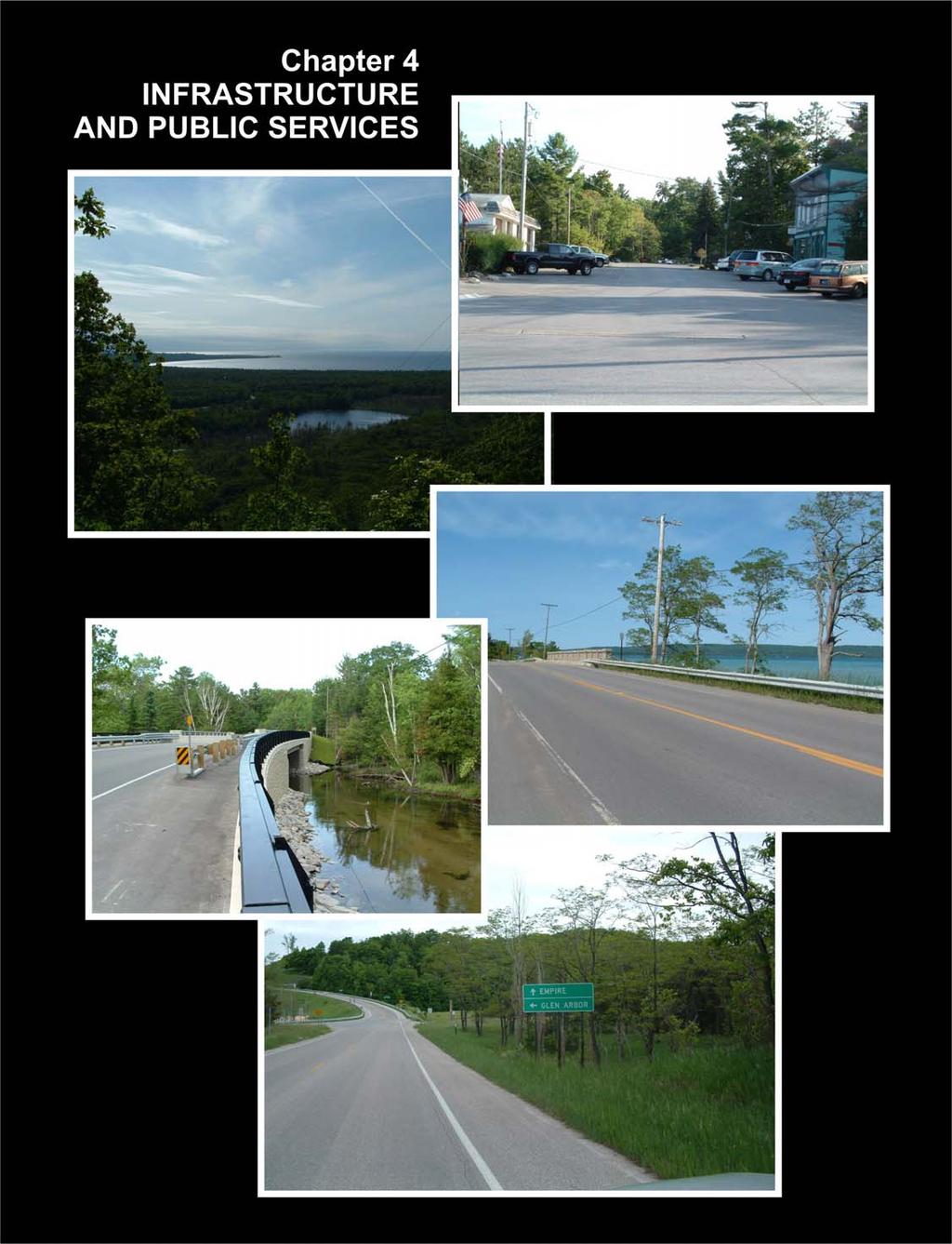
2 CHAPTER 4 INFRASTRUCTURE AND PUBLIC SERVICES This Chapter discusses the community facilities, schools, utilities and transportation system of Glen Arbor Township. It looks at present conditions and future needs. Township Hall The Township Hall is a large building located at 6394 West Western Avenue midway between Lake and Oak on the north side of the street, across from the old schoolhouse. See Map 4-1. The front three-quarters of the Township Hall is an historic gymnasium with an old barn-style roof. There is also a stage and a large kitchen. The room easily accommodates several hundred persons seated at tables and is used for a wide range of activities from Town Meetings to educational programs. The rear portion of the Township Hall is much smaller and the Township offices occupy one large room, while a smaller room is used for meetings by Township boards and commissions. The Township Board is comprised of five members and meets regularly on the third Tuesday of each month. The Township Board is the elected, governing body of Glen Arbor Township that adopts ordinances and manages the operations of the Township. The Township Planning and Zoning Commission has seven members and meets the first Tuesday of each month. The Planning and Zoning Commission is an appointed group responsible for advising the Township Board on planning and zoning issues and administering land use regulations for the Township. Photo 4-1 Glen Arbor Township Hall Photo by Terry Gretzema 4-1

3 Located behind the Township Hall is public parking that is used seasonally for tourists, as well as for any other events. Weekly, during the summer, this parking lot is turned into a farmers market. Map 4-1 Township Buildings and Recreation Facilities in Glen Arbor Garden & Restrooms Graphic by John Warbach, Planning & Zoning Center, Inc. Fire, EMS and Rescue Services The Glen Arbor Fire and Rescue Department, which operates as The Glen Lake Fire and Rescue Department (GLFD), is a 24 hour a day, seven days a week service, staffed by a full-time chief and full-time core members, supplemented by a small contingent of part-time personnel. Many Department members are certified Michigan firefighters and/officers and licensed as either paramedics (EMT-P) or basic emergency medical technicians (EMT-B). The Department operates from two stations: the Public Safety Building, located at 6401 W. State Street in Glen Arbor, is staffed full time with one paramedic and three firefighter/emt-bs; The fire station in Empire, located at LaCore Ave, is staffed full time with two firefighter/emt-bs. Shift staffing is augmented during the peak, summer months and personnel and equipment from either or both stations will respond to calls separately or together, depending on the nature and location of each incident. 4-2

4 The Department provides Advanced Life support (ALS) medical services, including transport and ice rescue, plus fire fighting services, vehicle extrication, high angle rescue at the Dunes, search and rescue, plus a newly added 28 foot marine rescue/fire fighting boat to service Glen Lake and Lake Michigan, as well as surrounding properties, in coordination with the U.S. Coast Guard. This important new capacity will require continuing study for ways to improve the access to Lake Michigan available at the Township s Lake Street launch site. The Department operates two ambulances, one ALS and one Basic, plus a Pierce Ladder Truck (105 ), two Pierce Engines, two Pierce 2,000 gallon Tanker/Pumpers, one Pierce Rescue Squad, a Viking custom 28 foot Rescue/Fire Boat, two Polaris Ranger ATV s used for wildland fire and medical rescue, and a Ford Command Vehicle. The Department participates with and provides assistance to other county fire departments under a mutual aid agreement. Public education programs and CPR classes are made available to the public throughout the year. For the calendar year 2010, the Department responded to 171 fire calls and 398 medical calls. Staffing of the Department consists of 19 full-time and 12 part-time members, all of whom are cross trained and licensed/certified in both the fire and medical disciplines An aggressive professional development program is conducted on a continuing basis through the year amounting to 4,580 hours during Photo 4-2 Glen Arbor Public Safety Building Photo by Terry Gretzema Munson Health Care, based in Traverse City, is the major healthcare provider for Leelanau County. Leelanau Urgent Care in Lake Leelanau also provides medical 4-3

5 services. The Paul Oliver Memorial Hospital located southwest of Glen Arbor in Frankfort, Michigan is now the next closest hospital to Munson. Public Safety The Law Enforcement Division of the Leelanau County Sheriff s Office provides 24-hour law enforcement to 11 townships and three villages, including Glen Arbor Township. The Law Enforcement Division is comprised of three sergeants and 13 deputies that act as first responders to a variety of requests for police services. The division also conducts preliminary investigations, follow-up investigations, and self-initiated enforcement activities. Park Rangers work closely with the Leelanau County Sheriff s Department and provide emergency assistance to county officers when requested. The Marine Safety Unit of the Sheriff s Office patrols the waterways within Glen Arbor Township and Leelanau County. This unit responds to distress and emergency calls in all weather conditions, while working in concert with the United States Coast Guard and the Michigan Department of Natural Resources. Glen Arbor Township is located within the Michigan State Police s Seventh District. The community is served by the Michigan State Police post located in Traverse City. Photo 4-3 Leelanau County Sheriff s Photo courtesy Leelanau County website Parks and Recreation Glen Arbor Township s location amidst miles of National Lakeshore, sand dunes, inland lakes, rivers and streams provides numerous recreational opportunities to seasonal and year-around residents and tourists. Activities such as camping, fishing, hiking, skiing, and golfing are all readily accessible within the community. During the summer months, many seasonal residents and tourists flock to the area to take advantage of its intrinsic natural beauty and recreational opportunities. Recreational facilities are located on Map 4-1 and include: Glen Arbor Township Hall Gymnasium: Contains indoor basketball court, restroom facilities, and a stage. Glen Arbor Township Park: Contains a basketball court, four tennis courts, and a childrens play area with a variety of playground equipment. 4-4
6 Glen Arbor Boat Ramp: Boat launch located on Lake Michigan. Beach Facilities: Beaches are located on both Lake Michigan and Little Glen Lake and provide limited parking. Crystal River Canoe Access: A narrow strip of land from the road to the water, accessed along M-22. Two privately owned canoe outfitters rent canoes, kayaks, and bicycles. Little Glen Lake Access at the Narrows: Small beach with large amounts of poison ivy. This is a narrow strip of land from the road to the water with no public parking. Miller Hill Lookout Park: A small undeveloped park at the juncture of Miller Hill and the power lines. Sleeping Bear National Lakeshore: 26 square miles of National Park containing a campground, numerous historic buildings, a maritime museum, a dune climb and scenic drive, cross-country and snowshoe trails, canoeing and fishing opportunities, and a visitor s center. The Homestead: A privately owned resort that includes a golf course, swimming pools, tennis courts, ski trails and hills, and showshoe and cross-country trails. Golf Courses Golfers in the Glen Arbor community have access to several golf courses within Leelanau County. Within Glen Arbor, golfers need to look no further than The Homestead Resort, which features a 9-hole course that is unique in that the golf facility shares the same area as the ski layout during the changing seasons. The Homestead is a par 3 course with a hilly design and an abundance of trees. The variable elevation provides beautiful views of Lake Michigan, Manitou Passage, and North and South Manitou islands. ; In addition, golfers can take advantage of The Sleeping Bear Golf Club north of Cedar; Dunes Golf Club, an 18-hole course east of Empire; and the Leelanau Club at Bahle Farms in Sutton s Bay The old golf course of Sugar Loaf. The Manitou Passage Golf Course, is the former Kings Challenge Golf course located 7 miles from the Homestead Resort. This beautiful 18 hole golf course has been redeveloped and redesigned in the Arnold Palmer standard. Leland Country Club, is a private course that features and 18 hole course on rolling terrain with fairways lined with mature maple, birch, oak and beech trees. School System Glen Arbor Township is served by the Glen Lake Community School District, part of the larger Traverse Bay Area Intermediate School District. Glen Lake Community Schools encompass 200 square miles and serves 6,032 year round residents. See Map 4-2. Glen Lake schools have a district-wide enrollment of 930 students. In 2003, the district received operating revenue of $6,888 per student from the state of Michigan. All Glen Lake schools are fully accredited by the North Central Association and the district was one of the first districts within the state to receive K-12 North Central accreditation. Glen Lake High School was built in 1958 and received improvements in 1968 and The elementary school and middle school wing was added in During the school year, the high school received 50% additional instructional space. 4-5

7 Presently, Glen Lake Elementary School educates students in grades kindergarten through fifth grade. Glen Lake High School, which also houses the middle school, has grades six through twelve. The student-teacher ratio at the elementary school is 18 to 1 while the student-teacher ratio at the high school is 21 to 1. Interscholastic sports at both the middle school and high school levels allow students to participate in varsity, junior varsity and available freshman teams in any offered sport. Map 4-2 Glen Lake Community School District Source: Leelanau General Plan Library The Glen Lake Community Library has served Glen Arbor, Empire, and Kasson Townships since In 1983, the library moved into the former Empire Fire Hall. The 4-6

8 overwhelming approval of a property tax levy in 1996 by all three townships allowed for major renovation and expansion, which was completed in October The library offers over 19,000 items, including 13,000 book titles, 800 recordings on tape or compact disc, over 2,000 videotapes and DVD s, and nearly 50 periodicals and newspapers. The library also has public computers with high speed internet access. The library provides information materials and services to all community residents and visitors on an equal, publicly funded basis. A Board of Trustees, comprised of residents from all three townships, governs operational and financial matters. Highways Glen Arbor is served by two state trunklines, M-22 and M-109. M-22 is designated as the major access route into the Township. It passes along the west side of Big Glen Lake and across the Narrows. The road along Glen Lake winds and is tree-lined. The Narrows is a congregating place for visitors who like the view, for fisherman off the bridge, and for customers at the marina. This attraction sometimes creates hazardous traffic situations. Map 4-3 depicts the system of roads in Western Leelanau County. Map 4-3 Roads in Western Leelanau County 4-7
9 M-22 serves as both a major transportation artery for the County and as a corridor for viewing some of the country's most scenic vistas. As such, MDOT has designated M-22 and M-109 as a Scenic Heritage Route. The Heritage Route program was initiated through legislation in 1993 and emphasizes cooperation among local residents, their government officials, landowners and interested groups to preserve unique scenic, historic or recreational highways. The Scenic Historic Route designation ensures that the rural character of Leelanau County is preserved and that the inherent qualities of the peninsula continue to be showcased. In 2002, MDOT helped secure funding from the U.S. Department of Transportation to designate M-22 in Leelanau County as a National Scenic Byway. National Scenic Byway funds enable states to embark on eligible projects along highways designated as National Scenic Byways and state-designated byways. Planning projects to inventory, preserve and enhance the qualities of the byway, safety improvements, construction of bike and pedestrian facilities, and resource protection such as scenic easements are eligible within this program. While MDOT paved much of M-22 from Empire to Glen Arbor in 2003 and 2004 as well as M109 in 2004, and maintained a paved shoulder which is useful for bicyclists, an ongoing effort is underway by the Sleeping Bear Heritage Trail (SBHT) to complete a bike trail. The SBHT will be a hard-surfaced multiuse trail paralleling M-22 and M-109 for 27 miles through the Lakeshore. It will provide a safe, non-motorized, multi-use transportation alternative connecting the Lakeshore s main visitor destinations with Glen Arbor and Empire The SBHT will give walkers, runners, wheelchair users, bicyclists, cross-country skiers, baby strollers, and rollerbladers a safe, enjoyable and carefree way to access and explore the Lakeshore and neighboring communities. M-22 is an arterial road, while M-109, Glen Haven Road (former M-209) and County Road 675 are collector roads. All other public roads are local streets. There are also many private roads that provide access to property like local streets. M-22 and M-109 are maintained by MDOT, while all other public roads in the Township are maintained by the Leelanau County Road Commission. Traffic Counts By most traffic engineering standards, traffic, even during the peak summer months is limited. However, that does not mean that residents are not sensitive to it nor concerned about it. The biggest concerns are on M-22 from the Narrows to Glen Arbor where many homes are very close to the road and there is little road shoulder in many places. Similar concerns exist along M-109 on the west end of Little Glen Lake where most homes are set farther back but speeds are higher. Map 4-4 depicts average daily traffic volumes as measured by MDOT and published in its 2003 traffic count map. These are days averaged across the year, not peak days. 4-8
.")
10 Map 4-4 Traffic Counts Average Daily Traffic (number of vehicles per day) Source: MDOT, 2004 Utilities In Glen Arbor Township, natural gas and electricity are provided by private companies. At present, public sewer and water services are nonexistent. Natural gas in Glen Arbor is provided by Michigan Consolidated Gas Company (MichCon). Consumers Energy provides electricity to residents, businesses and institutions in the Glen Arbor community. Century Telephone and Ameritech provide local phone service. Cable is provided by Charter Communications, Inc. Fiber optic service is available. 4-9
CHAPTER 4 INFRASTRUCTURE AND PUBLIC SERVICES
 CHAPTER 4 INFRASTRUCTURE AND PUBLIC SERVICES This Chapter discusses the community facilities, schools, utilities and transportation system of Glen Arbor Township. It looks at present conditions and future
Non-Motorized Transportation
 Non-Motorized Transportation Non-motorized facilities are important components to the transportation system. They provide an environmentally-friendly, low-cost mode of travel. Some of the facilities can
GENERAL INFORMATION SIGNS
 GENERAL INFORMATION SIGNS I 1-1 THROUGH I14-1b RECREATIONAL AND CULTURAL INTEREST AREA SIGNS Michigan Department of Transportation Traffic and Safety PW Reference Documents\Traffic Reference\Typicals\Develop\Sign_StdHwySigns_D\i00_titlepage_i.dgn
University Region Non-Motorized Plan 2015
 Non-Motorized Transportation Non-motorized facilities are important components to the transportation system. They provide an environmentally-friendly, low-cost mode of travel. Some of the facilities can
A Publication of Friends of Sleeping Bear Dunes
 A Publication of Friends of Sleeping Bear Dunes 2014, Friends of Sleeping Bear Dunes, P.O. Box 545, Empire, MI 49630 www.friendsofsleepingbear.org info@friendsofsleepingbear.org Learn more about the Friends
2. Goals and Policies. The following are the adopted Parks and Trails Goals for Stillwater Township:
 D. PARKS AND TRAILS 1. Introduction Stillwater Township s population is relatively low, with most residents living on rural residences on large lots. The need for active park space has been minimal in
Chapter 6. Action Program. Heart of the Lakes Area Recreation Plan
 Heart of the Lakes Area Recreation Plan 1. Design and construct the following trails (please see the following map): a. the Speedway Trail 1) primary pathway the main trail 2) secondary pathway the proposed
EMPLOYMENT OPPORTUNITY. Police Chief. Buena Vista Charter Township
 EMPLOYMENT OPPORTUNITY Police Chief Buena Vista Charter Township Police Chief BUENA VISTA CHARTER TOWNSHIP Buena Vista Charter Township is located in Saginaw County, Michigan. The township strives to be
200' to Beach,Wi-Fi,AC,Hot Tub,Golf Cart,Lakeviews,2000sf,3BR,2 Bth
 200' to Beach,Wi-Fi,AC,Hot Tub,Golf Cart,Lakeviews,2000sf,3BR,2 Bth Summary We call our home our Kidcatcher. Description We call our home our Kidcatcher. The kids love to come back to this house to catch
SUGAR BEACH V I L L A S L U X U R Y C O N D O M I N I U M S
 31 TRAVERSE CITY 37 Peninsula Dr Center Rd Grand Traverse Bay 31 ACME 72 Munson Ave Parsons Rd 72 3 Mile Rd N Sugar Beach Villas FIVEMILE CORNER 620 S Airport Rd W 611 Garfield Rd N 660 Hammond Rd E 5
GENERAL INFORMATION SIGNS
 GENERAL INFORMATION SIGNS I 1-1 THROUGH I13-2 RECREATIONAL AND CULTURAL INTEREST AREA SIGNS CLEARVIEW FONT MI/2012 Michigan Department of Transportation PW: Reference Docum ents\traffic Reference\Typicals\Develop\Sign_StdHwySigns_D\I00_titlepage_e.dgn
Acquisition in fee simple of approximately one-half acre of property on the shore of Spring Lake to expand the Lakeside Beach Park.
 Lakeside Beach TF00-136 $122,550.00 in fee simple of approximately one-half acre of property on the shore of Spring Lake to exp the Lakeside Beach. 2000 River Ravines TF00-150 $910,000.00 in fee simple
WASHINGTON STATE PARKS LAND CLASSIFICATION SYSTEM
 WASHINGTON STATE PARKS LAND CLASSIFICATION SYSTEM Administrative Code Establishing Land Classification System WAC 352-16-020 Land classification system. State park areas are of statewide natural, cultural,
CHAPTER 5. Chapter 5 Recreation Element
 CHAPTER 5 Recreation Element Chapter 5 Recreation Element The Recreation Element of the Meyers Area Plan is a supplement to the Recreation Element of the TRPA Regional Plan and the El Dorado County General
TOURISM & PUBLIC SERVICES RURAL SIGNAGE POLICY
 Policy and Procedures Subject Title: Tourism and Public Services Rural Signage Policy Corporate Policy (Approved by Council): X Policy Ref. No.: ROADS-01-07 Administrative Policy (Approved by CAO): By-Law
Township Superintendent
 EMPLOYMENT OPPORTUNITY Township Superintendent Buena Vista Charter Township Township Superintendent BUENA VISTA CHARTER TOWNSHIP Buena Vista Charter Township, located in Saginaw County, Michigan, strives
Lewis and Clark Recreation Area
 Lewis and Clark Recreation Area Bicycle/Pedestrian Trail Also part of the Pierson Ranch Recreation Area trail Type of trail: Walking, biking and rollerblading Trail surface: Asphalt Rated: Mostly flat.
4.0 OUTDOOR RECREATION 4.1 PUBLIC LANDS
 4.0 OUTDOOR RECREATION 4.1 PUBLIC LANDS Public lands provide a wide range of recreational opportunities and are considered a valuable community asset. There may be seasonal and/or other use restrictions
Public Park System. Township of Derry. Providing natural open space for the recreational use of our residents and guests.
 Township of Derry Public Park System Providing natural open space for the recreational use of our residents and guests. Directory of Recreational Amenities Hershey s Commitment to Recreation Famous candy
Bridge Collapse. Minneapolis Public Works Department. Presented by Steven Kotke, P.E. - Director of Public Works
 Bridge Collapse Minneapolis Public Works Department Presented by Steven Kotke, P.E. - Director of Public Works 1 St. Anthony Falls I-35W Bridge History Construction started in 1964 Opened to traffic in
Northeast Quadrant Distinctive Features
 NORTHEAST QUADRANT Northeast Quadrant Distinctive Features LAND USE The Northeast Quadrant includes all the area within the planning area that is east of Interstate 5 and to the north of State Route 44.
Business Item No XXX. Proposed Action That the Metropolitan Council approve the Coon Creek Regional Trail Master Plan.
 Business Item No. 2015-XXX Metropolitan Parks and Open Space Commission Meeting date: July 7, 2015 For the Community Development Committee meeting of July 20, 2015 For the Metropolitan Council meeting
Chapter eight. Parks and Recreation. Introduction. Crystal Lake Park District
 Chapter eight Parks and Recreation Introduction One of the indicators of quality of life in a city is the parks and recreation system. The City of Crystal Lake is fortunate to have an excellent parks and
A Leelanau County guide to scenic, historic and recreational opportunities along one of Michigan s designated highways
 Resources Leelanau Scenic Heritage Route Committee c/o Northwest Michigan Council of Governments PO Box 506; Traverse City MI 49684 231-929-5000 http://www.m22leelanauheritageroute.org/ Sleeping Bear Dunes
A Publication of Friends of Sleeping Bear Dunes
 2019, Friends of Sleeping Bear Dunes, P.O. Box 545, Empire, MI 49630 www.friendsofsleepingbear.org info@friendsofsleepingbear.org Learn more about the Friends of Sleeping Bear Dunes, our mission, projects,
TART Trails, Inc. (231)
") TART Trail System TART Trails, Inc. www.traversetrails.org (231) 941-4300 Leelanau Trail Stretching 15 miles along a former railroad corridor, the TART-owned Leelanau Trail connects Traverse City and Suttons
TART Trail System TART Trails, Inc. www.traversetrails.org (231) 941-4300 Leelanau Trail Stretching 15 miles along a former railroad corridor, the TART-owned Leelanau Trail connects Traverse City and Suttons
TRUCKEE TAHOE AIRPORT DISTRICT BOARD OF DIRECTOR STAFF REPORT
 AGENDA ITEM: 11 TRUCKEE TAHOE AIRPORT DISTRICT BOARD OF DIRECTOR STAFF REPORT AGENDA TITLE: MEETING DATE: January 24, 2018 PREPARED BY: NTPUD Agency Partnership Opportunity, Multi-Use Trailhead Access
Crystal Lake Area Trails
 Lake Area Trails Welcome to the Lake area of the Big Snowy Mountains! This island mountain range in central Montana features peaks reaching to 8,600 feet and long, high ridges from which vistas of the
Understanding user expectations And planning for long term sustainability 1
 Understanding user expectations And planning for long term sustainability 1 What is a natural surface trail? It can be as simple has a mineral soil, mulched or graveled pathway, or as developed as elevated
Maple Grove, beach home 10 min. to Traverse City, 20 min. to Sleeping Bear
 Maple Grove, beach home 10 min. to Traverse City, 20 min. to Sleeping Bear Summary Sandy beach, 3 bdrm, 2 bath, fireplace, central air, WiFi, 10 minutes to Traverse City, 20 minutes from Sleeping Bear
MASTER PLAN EXECUTIVE SUMMARY
 Biscuit Run State Park Scottsville Road (State Route 20) Charlottesville, VA 22902 Biscuit Run State Park MASTER PLAN EXECUTIVE SUMMARY Department of Conservation and Recreation Division of Planning and
Blueways: Rivers, lakes, or streams with public access for recreation that includes fishing, nature observation, and opportunities for boating.
 Parks, Open Space and Trails PRINCE WILLIAM COUNTY 2008 COMPREHENSIVE PLAN TRAILS PLAN CONTENTS The components of the trails plan are: Intent Definitions Goals, Policies, and Action Strategies Trails Map
Lincoln County ORP Survey Response Summary
 Lincoln County ORP Survey Response Summary North Central Wisconsin Regional Planning Commission Q1 Which recreational activities did you participate in during 2015? (Choose all that apply.) Answered: 125
A CASE FOR COMPLETING THE JORDAN RIVER PARKWAY: A
 A CASE FOR COMPLETING THE JORDAN RIVER PARKWAY: A safe crossing at 9000 South and 850 West Proposed 9000 South Underpass Parkway Timeline Parkway, Trail, and Tourism Facts Blueprint Jordan River 1971 1973
4.19 Parks, Recreation, and Conservation Lands
 interchange would have on the Reed Paige Clark Homestead located on the north side of Stonehenge Road. Alternative D would also affect Palmer Homestead, E.F. Adams House, and Knapp Brothers Shoe Manufacturing
Emily to Blind Lake Trail PROPOSED TRAIL DEVELOPMENT APPLICATION SUMMARY
 Emily to Blind Lake Trail PROPOSED TRAIL DEVELOPMENT APPLICATION SUMMARY Township 137 Range 26 (Fairfield Township) sections 2 & 3 Township 138 Range 26 (City of Emily) sections 27, 34, 35, & 36 Township
CHAPTER 4 EXISTING PARKS AND RECREATION FACILITIES INVENTORY
 CHAPTER 4 EXISTING PARKS AND RECREATION FACILITIES INVENTORY Existing park and recreation sites and facilities provide the basis upon which to build a park and recreation plan for the city. This inventory
CHAPTER FOUR: TRANSPORTATION
 CHAPTER FOUR: TRANSPORTATION Barron County Comprehensive Plan: Transportation Page 61 Background Transportation facilities have a significant influence on land use, development and quality of life for
PUBLIC INPUT MEETING Heart of Navarre Tourism Corridor September 27, 2016
 PUBLIC INPUT MEETING Heart of Navarre Tourism Corridor September 27, 2016 Meeting Overview What is the Heart of Navarre Tourism Corridor? Highway 98 from Ortega to Andorra Street County-owned portion
Yuba Creek Natural Area Acquisition. Acme Township. Acme Township. TF Acquisition $1,576, Grand Traverse
 Yuba Creek Natural Area TF00-162 $1,576,021.00 in fee simple of 403 acres of critical wetls upl habitat with over 5,000 feet of frontage on Yuba Creek, a tributary to the east arm of Bay. 2000 Petobago
Committee Report. Community Development Committee For the Metropolitan Council meeting of August 12, Business Item No.
 Committee Report Business Item No. 2015-168 Community Development Committee For the Metropolitan Council meeting of August 12, 2015 Subject: Coon Creek Regional Trail Master Plan, Anoka County Proposed
POLICY DCS-04: Tourism Directional Sign Policy. Development and Cultural Services
 DCS-04 Page 1 of 8 POLICY DCS-04: Tourism Directional Sign Policy Development and Cultural Services Approval Date: March 11, 2008 Approval Authority: Council, Resolution No. 7 Effective Date: March 11,
Sierra Sacramento Valley EMS Agency Program Policy. EMS Aircraft Operations
 Sierra Sacramento Valley EMS Agency Program Policy EMS Aircraft Operations Effective: 06/01/2016 Next Review: 04/2019 450 Approval: Troy M. Falck, MD Medical Director Approval: Victoria Pinette Executive
Lake Myra County Park. Wake County, North Carolina Community Forum #2 June 12, 2008
 Lake Myra County Park Wake County, North Carolina Community Forum #2 June 12, 2008 Welcome and Introduction Meeting Agenda Welcome Introductions of Project Team Master Plan Process Community Forum #1 Updates
Economic Development and Tourism
 SECTION 4 SECTION 4 Economic Development and Tourism 4. Economic Development and Tourism Tourism plays a very important role in Niagara s economy, providing employment and generating business for support
9/10/2012. Chapter 54. Learning Objectives. Learning Objectives (Cont d) Wilderness EMS
 Wilderness EMS") Chapter 54 Wilderness EMS 1 Learning Objectives Define and describe wilderness medicine and wilderness EMS Define and describe the wilderness EMS system Describe the differences in practice environments
Chapter 54 Wilderness EMS 1 Learning Objectives Define and describe wilderness medicine and wilderness EMS Define and describe the wilderness EMS system Describe the differences in practice environments
Topsham Trail Guide.
 Topsham Trail Guide A guide to the walking, hiking, biking, water and ATV trails of Topsham, Maine and surrounding towns $4.95 Developed by the www.greatertopshamtrailalliance.org The Greater Topsham Trail
RECREATION ACCESS AND COMMUNITY ENRICHMENT PLAN
 Template for facilitating Siskiyou County, the City of Yreka and the State of Jefferson in a RECREATION ACCESS AND COMMUNITY ENRICHMENT PLAN Access to the Mountains CREATING ACCESS TO PUBLIC AND PRIVATE
Segment 2: La Crescent to Miller s Corner
 goal of the USFWS refuges is to conserve, protect and enhance fish, wildlife and plants and their habitats for the continuing benefit of the American people. Refuge lands are used largely for fishing,
FINAL TESTIMONY 1 COMMITTEE ON RESOURCES UNITED STATES HOUSE OF REPRESENTATIVES. July 13, 2005 CONCERNING. Motorized Recreational Use of Federal Lands
 FINAL TESTIMONY 1 STATEMENT OF DALE BOSWORTH CHIEF Of the FOREST SERVICE UNITED STATES DEPARTMENT OF AGRICULTURE Before the SUBCOMMITTEE ON FORESTS AND FOREST HEALTH And the SUBCOMMITTEE ON NATIONAL PARKS,
Department of Legislative Services Maryland General Assembly 2009 Session
 Department of Legislative Services Maryland General Assembly 2009 Session SB 650 FISCAL AND POLICY NOTE Senate Bill 650 (Senators Pipkin and Astle) Finance and Budget and Taxation Medevac Helicopter Improvement
OPEN SPACE. The Open Space Element describes the County s goals and policies with respect to open space areas and addresses the following topics:
 PURPOSE This element addresses open spaces for: the managed production of resources, outdoor recreation, public health and safety, and the preservation of natural resources. Amador County s open space
CHAPTER 2H. RECREATIONAL, HISTORICAL MARKER, TRAFFIC GENERATOR AND CULTURAL INTEREST AREA SIGNS
 2006 Edition Page 2H-1 CHAPTER 2H. RECREATIONAL, HISTORICAL MARKER, TRAFFIC GENERATOR AND CULTURAL INTEREST AREA SIGNS Section 2H.01 Scope Recreational or cultural interest areas are attractions or traffic
Rating: 5.0 (scale of 1-10)
") 95 Community Trail System Groundcover: 2-metre paved path, 1- metre grass buffer on either side. Location: Fort St. John Ownership: City of Fort St. John Rating: 5.0 (scale of 1-10) Strategic value: Linear
95 Community Trail System Groundcover: 2-metre paved path, 1- metre grass buffer on either side. Location: Fort St. John Ownership: City of Fort St. John Rating: 5.0 (scale of 1-10) Strategic value: Linear
CHAPTER 9. PARKS, RECREATION, TRAILS AND NATURAL AREA RESOURCES
 CHAPTER 9. PARKS, RECREATION, TRAILS AND NATURAL AREA RESOURCES The forms of recreation chosen by residents and visitors in the CBJ are as diverse as the population. Many people choose to recreate in developed
Tracy Ridge Shared Use Trails and Plan Amendment Project
 Tracy Ridge Shared Use Trails and Plan Amendment Project Scoping Document Forest Service Allegheny National Forest Bradford Ranger District McKean, County, Pennsylvania In accordance with Federal civil
Classrooms & Resources Available. Regional Public Safety Training Center
 Classrooms & Resources Available Regional Public Safety Training Center Note: If you are viewing this PDF online, the Room numbers are clickable links to pages specific to those rooms. Standard Classrooms
Trail Etiquette. Hours of Operation. Trail Accessibility
 Trail Guide The Elmhurst Park District, with 28 parks and over 460 acres of land, offers nearly six miles of paved or asphalt park trails and maintains an additional 3.6 miles of trails within Elmhurst.
PUBLIC SAFETY. FY 2015 BUDGET Prince William County CIP-PUBLIC SAFETY 551
 PUBLIC SAFETY FY 2015 BUDGET Prince William County CIP-PUBLIC SAFETY 551 PUBLIC SAFETY 552 CIP-PUBLIC SAFETY Prince William County FY 2015 BUDGET Bacon Race Station Total Project Cost - $11.2 M The station
4. Safety Concerns Potential Short and Medium-Term Improvements
 NH Route 104 Access Management Study Page 19 4. Safety Concerns Potential Short and Medium-Term Improvements Potential safety improvement strategies are listed by priority based on field observations by
chapter - Hex Highway Touring Route Hamburg to Strausstown Overview
 chapter - 2 Hex Highway Touring Route Hamburg to Strausstown Overview The on-road Hex Highway automobile and bicycle touring route begins on State Street in downtown Hamburg. The route continues west on
Willow Cottage on beach 10 minutes from Traverse City
 Willow Cottage on beach 10 minutes from Traverse City Summary Willow Cottage is one of 3 cottages that make up our small lakeside resort. It is located on 1.2 acres of land, with 70 ft of sandy Silver
2014 REVENUES by SOURCE OPERATING REVENUES HISTORY SUMMIT COUNTY OPERATING FUNDS REVENUES. 60 Millions 50 9% 2% 45% 16% 16%
 SUMMIT COUNTY OPERATING FUNDS REVENUES TAXES 19,823,121 20,629,131 21,563,392 20,448,612 Property Taxes 22,865,800 22,865,800 6,913,712 7,297,403 7,600,000 7,700,000 Sales & Use Taxes 8,000,000 8,000,000
Wilds. Headwaters. Lakes. Oxbows. Falls
 56 5 4 3 Wilds Headwaters Lakes Oxbows Falls 57 Zones It could be said the on-the-ground essence of this master plan appears within the next 6 pages of this report. As we learned in the preceding Cultural
F. Forest Recreation Management
 F. Forest Recreation Management F.1) Park and Recreation Management F.1.A. Program Overview. The park and recreation program has been in existence since 1980. With ever increasing outdoor recreation demands
APPENDIX A: Survey Instruments
 Three different surveys were conducted during the research phase of the NCHA Trails Study. One questionnaire was designed for elected officials and user groups (general public). The other two questionnaires
DRAFT Scenic Byways & Regional Tourism
 11 Scenic Byways & Regional Tourism 2016 Regional Transportation Plan 11 Scenic Byways and Regional Tourism The five scenic byways in Franklin County play an important role in regional tourism. The five
Bike/Pedestrian/Golf Cart Trail Recommendations for the City of Dasher
 Valdosta-Lowndes MPO Memo To: From: City of Dasher Mayor and City Council VLMPO Staff CC: Date: 7/12/2018 Re: Bike/Pedestrian/Golf Cart Trail Recommendations for the City of Dasher The City of Dasher is
STANDARD OPERATING PROCEDURES TACTICAL OPERATIONS b AIRCRAFT INCIDENTS AND ACCIDENTS EFFECTIVE: OCTOBER 2007
 STANDARD OPERATING PROCEDURES TACTICAL OPERATIONS 202.15b AIRCRAFT INCIDENTS AND ACCIDENTS EFFECTIVE: OCTOBER 2007 AIRCRAFT INCIDENTS AND ACCIDENTS Goals 1. To familiarize with Airport Index 2. To familiarize
Project Summary 2009
 Project Summary 2009 SB-2009-MN-55360: Lady Slipper Scenic Byway Pedestrian Walkway State Submission Date not submitted Division Submission Date not submitted State Priority 0 This application must be
Greater Minnesota Regional Parks and Trails Commission Designation Application
 Greater Minnesota Regional Parks and Trails Commission Designation Application General Section Designation Application #: 16-043D Date Submitted: 04/28/2016 Park or Trail Name: Tioga Recreation Area District
Picture your next event in Novi!
 Picture your next event in Novi! Facility Reservation Guide Why Novi? Thank you for considering Novi as the location for your next event. We look forward to welcoming you at one of our unique venues which
TYPES OF LODGING PROPERTIES II. Based on Service Level Limited Service Properties
 TYPES OF LODGING PROPERTIES II Based on Service Level Limited Service Properties COPYRIGHT Copyright Texas Education Agency, 2011. These Materials are copyrighted and trademarked as the property of the
CHAPTER 4 -- THE LAND USE PLAN: DESCRIPTIONS AND POLICIES FOR THIRTEEN PLANNING AREAS
 CHAPTER 4 -- THE LAND USE PLAN: DESCRIPTIONS AND POLICIES FOR THIRTEEN PLANNING AREAS NORTH CENTRAL CAC AREA LITTLE VALLEY ROAD TO JUG HANDLE CREEK PLANNING AREA This planning area includes Cleone, Noyo,
RUSHMORE CONNECTOR TRAIL PROPOSAL
 PURPOSE AND NEED Background The U.S. Forest Service, Black Hills National Forest (Forest Service) has received a special use permit application from the State of South Dakota Department of Game, Fish and
Chambers of Commerce and Lake Groups advertised this NCWRPC created online survey that was : Opened: August 22, 2012; and Closed: October 4, 2012.
 Vilas County Outdoor Recreation Survey Chambers of Commerce and Lake Groups advertised this NCWRPC created online survey that was : Opened: August 22, 202; and Closed: October 4, 202. Q What Vilas County
City of Durango 5.8 FUNDING TRAILS DEVELOPMENT
 5.8 FUNDING TRAILS DEVELOPMENT The City has been successful in establishing dedicated local funding sources as well as applying for grants to develop the City s trail system, having received nearly $2.4
RAPID CITY REGIONAL AIRPORT
 RAPID CITY REGIONAL AIRPORT Budget: $16,232,274 Full time Employees: 24 Mission Statement It is the mission of the Rapid City Regional Airport Board to provide safe, efficient, environmentally sensitive,
Morgan Estates. Lassen County, CA. Proudly Offered By
 Morgan Estates Lassen County, CA Proudly Offered By 707 Merchant Street, Suite 100, Vacaville, Ca 95688 (707) 455-4444 Office (707) 455-0455 Fax info@caoutdoorproperties.com Introduction Looking North
DRIVING TOUR OF PICKETT COUNTY TN THROUGH PHOTOS Traveling east on Hwy 111 starting at the Overton/Pickett County Line
 DRIVING TOUR OF PICKETT COUNTY TN THROUGH PHOTOS Traveling east on Hwy 111 starting at the Overton/Pickett County Line Welcome Sign as one enters County County Line Flea Market and Auction Historic Church
NOTE: YOU MAY COMPLETE THIS SURVEY ONLINE (USING THIS DOCUMENT TO VIEW MAPS AND GRAPHICS) AT:
 AT:") for completing the Town of Beech Mountain Comprehensive Planning Survey. The information you provide in reply to the following questions will be used to help the Town develop a plan that will guide our
for completing the Town of Beech Mountain Comprehensive Planning Survey. The information you provide in reply to the following questions will be used to help the Town develop a plan that will guide our
KLHQ Fairfield County Emergency Response Plan (August 13, 2012)
") (August 13, 2012) Purpose The purpose of this plan is to ensure the safe and efficient handling of emergency situations that may arise at the Fairfield County (KLHQ) Lancaster, Ohio Airport. It is intended
(August 13, 2012) Purpose The purpose of this plan is to ensure the safe and efficient handling of emergency situations that may arise at the Fairfield County (KLHQ) Lancaster, Ohio Airport. It is intended
FILE NO. ANMICALGIC-1
 MUNICIPAL GOVERNMENT BOARD FILE NO. ANMICALGIC-1 IN TEE MATTER OF THE "Municipal Government Act" AND IN THE MATTER OF an application by the City of Calgary, in the Province of Alberta, to annex certain
System Group Meeting #1. March 2014
 System Group Meeting #1 March 2014 Meeting #1 Outcomes 1. Understand Your Role 2. List of Revisions to Existing Conditions 3. Information Sources Study Area The Purpose of Mountain Accord is to Preserve
13.1 REGIONAL TOURISM ISSUES AND SUMMARY OF FINDINGS
 13 REGIONAL TOURISM T he County of Mariposa s recreation needs and facilities fall within two categories: regional tourism and local recreation. This Element focuses on regional tourism issues related
Document prepared by MnDOT Office of Aeronautics and HNTB Corporation. MINNESOTA GO STATE AVIATION SYSTEM PLAN
 LAST UPDATE JULY 2013 Acknowledgements The preparation of this document was financed in part by a grant from the Federal Aviation Administration (Project No: 3-27-0000-07-10), with the financial support
OVERVIEW OF THE PROGRAM
 HeLa Ventures Site 147, Comp. 12, RR#4 Rocky Mountain House, AB T4T 2A4 Lana Ohler-Madsen, Director Phone: (780) 468-1492 Camp Phone: (403) 845-4325 Cell: (780) 932-4820 helaventures@gmail.com OVERVIEW
ADVENTURE PLAN EXPLORE PARK
 ADVENTURE PLAN ROANOKE COUNTY S EXPLORE PARK ROANOKE COUNTY PARKS, RECREATION AND TOURISM 1206 KESSLER MILL RD SALEM, VA 24153 (540) 387-6078 WHAT S INCLUDED? Explore Park Adventure Plan - Guided by extensive
CITY PARK SYSTEM FEES AND CHARGES PARKS AND NATURAL AREAS EFFECTIVE JANUARY 1, 2018
 CITY PARK SYSTEM FEES AND CHARGES PARKS AND NATURAL AREAS EFFECTIVE JANUARY 1, 2018 GENERAL PARK SYSTEM FEES GENERAL PARK SYSTEM FEES Large Land Use $500/day Medium Land Use $250/day Small Land Use $100/day
Park Design and Location Criteria
 Park Design and Location Criteria This section is presented in the interest of assisting park and recreation agencies in the development of a system of parks and recreation areas. A recreation system is
Directions to New Life Ranch
 Directions to New Life Ranch 160 New Life Ranch Drive / Colcord, Oklahoma 74338 / (918)422-5506 From Fayetteville & Springdale, AR: We are thirty miles west of Springdale on Highway 412. Four miles west
1. Overview of Aberdeen Township and Its Waterfront
 Aberdeen 1. Overview of Aberdeen Township and Its Waterfront 1.1 Geographic Overview Aberdeen Township is a suburban township with a land area of 5.45 square miles, with about 2 miles of shoreline along
County of Elgin Tourism Signage Policy Addendum A
 1.0 INTRODUCTION County of Elgin Tourism Signage Policy Addendum A 1.1 PURPOSE OF ELGIN TOURISM SIGNAGE POLICY To define the eligibility, use, design and authority for tourism oriented directional signage
SAN LUIS OBISPO COUNTY EMERGENCY MEDICAL SERVICES AGENCY PREHOSPITAL POLICY
 SAN LUIS OBISPO COUNTY EMERGENCY MEDICAL SERVICES AGENCY PREHOSPITAL POLICY Policy Reference No: 155 Effective Date: 05/01/2013 Supersedes: 07/29/2012 Review Date: 03/01/2015 SUBJECT: EMS AIRCRAFT (HELICOPTER)
By Julianna Roche. East Bay Beach in Traverse City State Park
 Travel: Northern Michigan Up North Adventures Beaches, DUNes, Festivals Await By Julianna Roche Homes, Cottages, Condos Vacations to remember in beautiful Northwest Michigan! Mention code CINCY12 when
West Point Project U.S. Army Corps of Engineers VOLUNTEER VACANCY ANNOUNCEMENT Posted: 1/12/2018
 West Point Project U.S. Army Corps of Engineers VOLUNTEER VACANCY ANNOUNCEMENT Posted: 1/12/2018 Current Volunteer Coordinator: Park Ranger Rebecca Downey Rebecca.m.downey@usace.army.mil 706-645-6113 West
Camping (Primitive) Camping (RV) Electrical Potable Water Grill Established Fire Pit Picnic Table
 Camping (RV) Electrical Potable Water Grill Established Fire Pit Picnic Table") Alden - 9th Road River Mile 777 Map: 38.20833, -98.32031 Managing Agency: Kansas Department of Wildlife, Parks & Tourism Nearest Community: Alden, Rice County Kansas Developed Amenities Provided Parking
Alden - 9th Road River Mile 777 Map: 38.20833, -98.32031 Managing Agency: Kansas Department of Wildlife, Parks & Tourism Nearest Community: Alden, Rice County Kansas Developed Amenities Provided Parking
Village of Taos Ski Valley 2015 Master Plan. Recreation Element
 Village of Taos Ski Valley 2015 Master Plan Taos Ski Valley is known across the world for skiing and winter sports, but the Village has more to offer than advanced skiing terrain and short lift lines.
East Bay Charter Township 1965 Three Mile Road North Traverse City, MI Regular Board Meeting Monday November 18, 2013
 East Bay Charter Township 1965 Three Mile Road North Traverse City, MI 49696 Regular Board Meeting Monday November 18, 2013 Call Meeting to Order: Chairman Lile called the meeting to order at 6:30pm. Pledge
375 Sheldon Road, Fair Haven, VT
 375 Sheldon Road, Fair Haven, VT Curtis Trousdale, Owner, Broker, Realtor Cell: 802-233-5589 curtis@preferredpropertiesvt.com 2004 Williston Road, South Burlington VT 05403 www.preferredpropertiesvt.com