2005 NEW MEXICO COMMUNITIES AT RISK ASSESSMENT PLAN
|
|
|
- Annabella Richards
- 5 years ago
- Views:
Transcription

1 2005 NEW MEXICO COMMUNITIES AT RISK ASSESSMENT PLAN ENERGY, MINERALS AND NATURAL RESOURCES DEPARTMENT FORESTRY DIVISION APRIL 2005
2 4/25/05 Cover photo: Defensible space efforts in the Ranches of Sonterra subdivision in the Greater Ruidoso Area. March 2004 Prepared by: Nancy Neskauskas EMNRD Forestry Division 2
3 Table of Contents Executive Summary Accomplishments..6 Table 1- Communities with Completed CWPPs 8 Figure 1- NM Community Protection Zones 9 Table 2- Communities at Risk List.. 10 Appendix 1- SW Area BIA Hazard Risk Rating Appendix 2-Community Wildfire Protection Plan Checklist Appendix 3-Community Protection Zone Maps...18 Appendix 4- Other Plans and Assessments Addressing Fire Hazards in New Mexico..55 Appendix 4-Reference List
4 4
5 EXECUTIVE SUMMARY The New Mexico Fire Planning Task Force (NMFPTF) was created by the 2003 New Mexico Legislature to identify wildland urban interface areas most vulnerable to danger from forest fire in the State of New Mexico. Additionally, the Task Force works with local governments in developing minimum standards for building codes and ordinances that will reduce the threat of forest fires to those communities. The NMFPTF annually reviews the Communities at Risk list, whether for the inclusion of new communities or the reduction of adjective ratings or the ultimate removal of communities from the list. By September 30 of each year the Communities at Risk subgroup of the NMFPTF identifies updates and revisions to the Communities at Risk list and submits these to the full NMFPTF for approval. By December 15 of each year the NMFPTF publishes updates and revisions to the list and provides a finalized report to the Governor and New Mexico legislature. The National Fire Plan has brought funding into the state for planning and treatment in fire prone areas. Matching complementary projects on private and adjacent federal lands continues to be the primary goal. This assessment highlights eighteen Community Protection Zones (in GIS polygon format) around the state. Inside these polygons are 224 communities. Using standard hazard risk rating methodology there are 136 communities rated high, 66 rated moderate and 22 rated at low risk from wildland fire. Highlights in the 2005 plan include the removal of 2 communities that have been determined to fall within the boundaries of the Village of Ruidoso. The addition of six communities to the list is being made after consultation with local community working groups in collaboration with state and federal partners. The completion of Community Wildfire Protection Plans for the Greater Ruidoso, Otero County and Black Range WUI groups. The communities listed annually in this publication will replace the January 2001 Federal Register listing for Communities at Risk. The information will be forwarded to federal cooperators for their use. 5
6 2004 ACCOMPLISHMENTS Community groups throughout New Mexico have had a busy year working on the ground to complete ongoing projects. At the same time many communities are completing their Community Wildfire Protection Plans in the nationally recommended format provided by the Society of American Foresters publication Preparing a Community Wildfire Protection Plan: A Handbook for Wildland- Urban Interface Communities available at (see Appendix 4) Funding requests for treatments in interface areas continues to exceed expectations as well as available funding. However community groups and state and local government continue to add projects and treat acres across the state. Two Wildland Urban Interface (WUI) groups presented requests to the Fire Planning Task Force Communities at Risk subgroup for consideration. The first was the Greater Ruidoso Area WUI group. The group revised the base map from the 2004 Communities at Risk (CAR) Plan (see page 45). There were changes to the boundaries to better reflect work in progress and future work plans. The group determined that the communities of Hollywood and Ponderosa Hills listed in the 2004 CAR Plan actual fall within the municipal boundaries of the Village of Ruidoso. These communities will be deleted from the list. Treatments are ongoing in these subdivisions under the auspices of the Village of Ruidoso. The Greater Ruidoso Area WUI working group has determined four additional communities for inclusion along with a hazard risk rating for the communities. They are Carrizo Canyon rated high, Ranches of Sontera rated high, Loma Grande rated high, and Angus rated high. Finally in October 2004 the group finalized the Greater Ruidoso Area Community Wildfire Protection Plan. All collaborating partners have signed off on the plan. The plan covers 14 high risk communities. The entire plan can be viewed at The Otero County WUI group worked diligently to complete the Otero County Wildfire Protection Plan in November The group revised the base map from the 2004 CAR Plan (see page 41). Areas in the eastern portion of the Mescalero Apache Reservation and southeast quadrants of the Lincoln National Forest were removed that pose little threat to homes and communities. The base map now better reflects areas where work is ongoing and projected in agency work plans. The entire plan can be viewed at 6
7 The Otero County WUI working group has determined that there are two additional communities for inclusion along with a hazard risk rating for the communities. They are Sunspot rated high due to the density and sensitive nature of scientific instruments located there and the community of Bent that has been rated at moderate risk. The Sierra County WUI group completed a Community Wildfire Protection Plan in January This work was completed after the Fire Planning Task Force Communities at Risk Subgroup met on November 16, In 2005 the Sierra County WUI group will petition the Communities at Risk Subgroup to approve the plan and include the communities of Monticello and Placitas. The entire plan can be viewed at The Sierra County WUI group has remapped the Black Range Community Protection Zones to more accurately reflect the occlude nature of the communities (see page 19). There are also two areas mapped along the lower Rio Grande. While there is no risk from wildland fire entering the adjacent communities of Truth or Consequences, Elephant Butte, Williamsburg and Arrey these communities can and will be impacted by smoke should these large areas of salt cedar and other invasive plants ignite. The northern area has mitigation work in progress funded by a Collaborative Forest Restoration Grant and mitigation activities are scheduled for the southern portion north of the community of Arrey. There has been a request from the US Fish and Wildlife Service (FWS) to include several communities that are in close proximity to FWS lands. There is concern that there could be a loss of funding to FWS if refuges are not associated with a community at risk. The two refuges of concern are the Bitter Lakes National Wildlife Refuge with the associated communities of Roswell, Acme and Melina and the Maxwell National Wildlife Refuge with the associated community of Maxwell. The FWS has made contact with local officials and completed some preliminary assessment work. The Communities at Risk Subgroup has tasked the FWS with increasing community involvement in the planning process before these communities are considered for inclusion as Communities at Risk. The Catron County WUI group is working on completion of a Community Wildfire Protection Plan with a target date of late spring The Grant County WUI group will be completing a Community Wildfire Protection Plan with a target date of Fall GIS work is being completed along the Middle Rio Grande Community Protection Zone. This is a challenging area as portions of four counties are included. The Community Wildfire Protection Plan for this area is anticipated to be completed in the summer of There are Community Wildfire Protection Plans underway in the Colfax/Taos, Espanola Bosque (including the Pilar area), City of Santa Fe, Greater Jemez, 7
8 Sandia/Manzano Mountains, Mora, Raton, Northern Rio Arriba County, and Western San Miguel areas that should be completed during calendar year The CWPP process is starting for the Truchas area of southern Rio Arriba County. This group has the potential of requesting Community at Risk status in the coming year. Again it should be noted that the communities listed within the polygons are by no means a final tally of areas at risk from wildland fire. Communities not listed have the opportunity to be included through the development of a Community Wildfire Protection Plan (CWPP). The 2005 Communities at Risk Plan highlights eighteen Community Protection Zones (in GIS polygon format) around the state. Inside these polygons are 224 identified communities. Using standard hazard risk rating methodology there are 136 communities rated high, 66 rated moderate and 22 rated at low risk from wildland fire. Communities are encouraged to contact their local Forestry Division district office for assistance. Agencies concerned with communities or occluded subdivisions near ecologically or culturally sensitive areas may have these areas considered for inclusion through the development of Hazard Risk Assessments that include a local community collaboration component. Through the use of CWPPs the Healthy Forest Restoration Act provides communities with the opportunity to influence where and how federal agencies implement fuel reduction projects on federal lands and how federal funds are distributed for projects on non-federal lands. Local CWPPs can take a variety of forms based on the publication Preparing a Community Wildfire Protection Plan: A Handbook for Wildland-Urban Interface Communities available at The communities listed annually in this publication will replace the January 2001 Federal Register listing for communities at risk. The information will be forwarded to federal cooperators for their use and reside in a database managed by the USGS that includes the name and latitude and longitude of each community. Table 1 Communities with Completed CWPPs Community Completion Date Available at Black Range/Sierra County January 2005 nmforestry.com Greater Ruidoso Area October 2004 nmforestry.com Otero County November 2004 nmforestry.com 8
9 FIGURE 1 9
10 TABLE COMMUNITIES AT RISK LIST COMMUNITY PROTECTION COMMUNITY RANKING ZONE Black Range/Sierra County Chloride H Black Range/Sierra County Hillsboro M Black Range/Sierra County Kingston M Black Range/Sierra County Poverty Creek M Black Range/Sierra County Winston H Catron Apache Creek M Catron Aragon M Catron Coyote Creek M Catron Cruzville M Catron Datil Area H Catron Elk Springs H Catron Glenwood M Catron Horse Mountain M Catron Jewett Gap H Catron Luna H Catron Mogollon H Catron Pie Town Area M Catron Quemado Lake Estates H Catron Rancho Grande Estates H Catron Reserve H Catron Wildhorse M Catron Willow Creek H Colfax/Taos Amalia M Colfax/Taos Angel Fire H Colfax/Taos Arroyo Hondo M Colfax/Taos Arroyo Seco M Colfax/Taos Black Lake H Colfax/Taos Costilla M Colfax/Taos Eagle Nest L Colfax/Taos El Padro L Colfax/Taos Idlewild H Colfax/Taos Lakeview Pines H Colfax/Taos La Lama L Colfax/Taos Latir H Colfax/Taos Questa M Colfax/Taos Red River M Colfax/Taos Shady Brook H Colfax/Taos Taos L Colfax/Taos Taos Pueblo H* Colfax/Taos Valle Econdido H *Hazard Risk rated by BIA 10
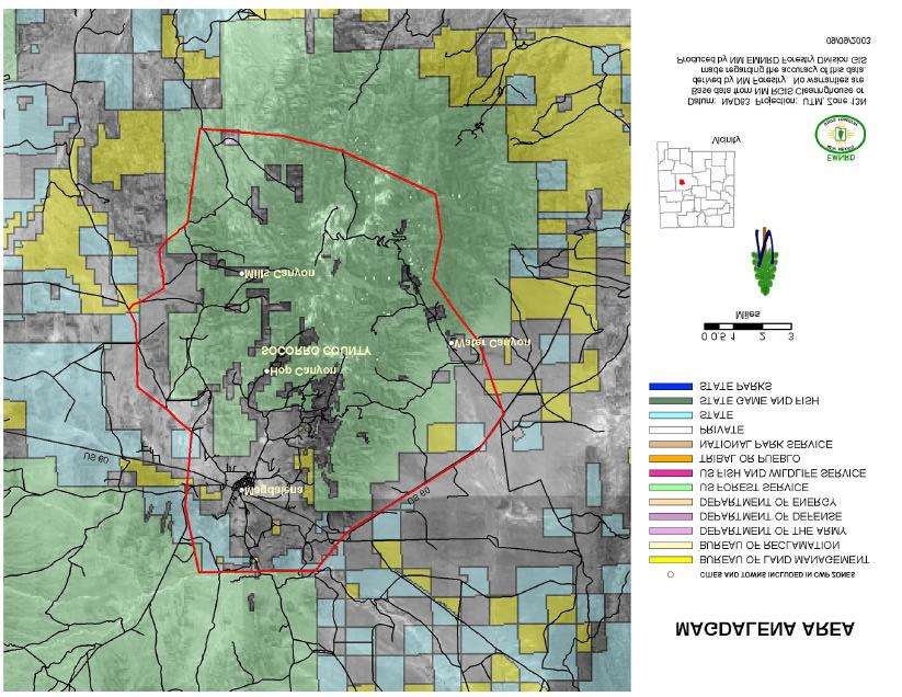
11 COMMUNITY PROTECTION ZONE COMMUNITY RANKING Espanola Bosque Alcalde M Espanola Bosque Chamita M Espanola Bosque Chili M Espanola Bosque Embudo L Espanola Bosque Espanola M Espanola Bosque Fairview M Espanola Bosque Hernandez H Espanola Bosque La Mesilla M Espanola Bosque Los Luceros M Espanola Bosque Lyden M Espanola Bosque San Juan Pueblo H* Espanola Bosque Santa Clara Pueblo H* Espanola Bosque Velarde L Grant Bayard M Grant Burro Mountain Area M Grant Hanover H Grant Lake Roberts H Grant LS Mesa H Grant Mimbres Valley H Grant Oak Grove H Grant Pinos Altos H Grant San Lorenzo M Grant Santa Clara M Grant Silver City M Grant White Signal H Greater Jemez Cochiti Mesa H Greater Jemez Fenton Lake State Park H Greater Jemez Jemez Springs M Greater Jemez La Cueva H Greater Jemez Seven Springs H Greater Jemez Sierra de Los Pinos H Greater Jemez Thompson Ridge H Los Alamos Los Alamos M Los Alamos White Rock M Magdalena Area Hop Canyon H Magdalena Area Magdalena M Magdalena Area Mills Canyon H Magdalena Area Water Canyon M 11
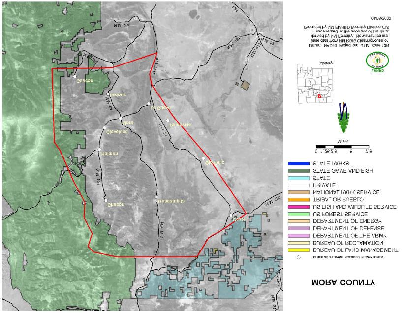
12 COMMUNITY PROTECTION COMMUNITY RANKING ZONES Middle Rio Grande Bosque Abeytas H Middle Rio Grande Bosque Albuquerque H Middle Rio Grande Bosque Belen H Middle Rio Grande Bosque Bernalillo H Middle Rio Grande Bosque Bernardo M Middle Rio Grande Bosque Bosquecito H Middle Rio Grande Bosque Cochiti Lake H Middle Rio Grande Bosque Cochiti Pueblo H* Middle Rio Grande Bosque Corrales H Middle Rio Grande Bosque Isleta Pueblo H* Middle Rio Grande Bosque La Joya H Middle Rio Grande Bosque Lemitar M Middle Rio Grande Bosque Los Lunas H Middle Rio Grande Bosque Los Ranchos H Middle Rio Grande Bosque Pena Blanca M Middle Rio Grande Bosque Peralta H Middle Rio Grande Bosque Placitas M Middle Rio Grande Bosque Pueblito H Middle Rio Grande Bosque San Acacia H Middle Rio Grande Bosque San Antonio M Middle Rio Grande Bosque San Felipe Pueblo H* Middle Rio Grande Bosque San Pedro H Middle Rio Grande Bosque Sandia Pueblo H* Middle Rio Grande Bosque Santa Ana Pueblo H* Middle Rio Grande Bosque Santo Domingo Pueblo H* Middle Rio Grande Bosque Socorro M Middle Rio Grande Bosque Valencia H Middle Rio Grande Bosque Veguita H Mora Chacon H Mora Cleveland H Mora Gascon H Mora Guadalupita H Mora Holman H Mora La Cueva M Mora Ledoux H Mora Mora H Mora Rainsville M Mora Ocate H Mora Ojo Feliz M 12
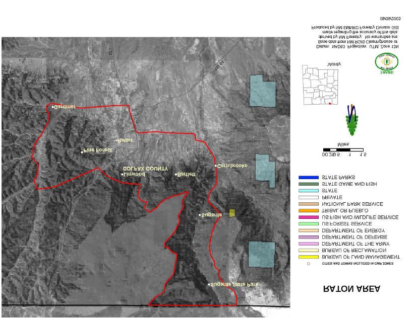
13 COMMUNITY PROTECTION ZONES COMMUNITY RANKING Otero Bent M Otero Cloudcroft H Otero Cox Canyon H Otero Dry Canyon H Otero High Rolls H Otero James Canyon H Otero Mayhill H Otero Mescalero Apache Res. H* Otero Sacramento H Otero Sixteen Springs H Otero Sunspot H Otero Timberon H Otero Weed H Raton Bartlett H Raton Carisbrooke L Raton Gardiner M Raton Linwood H Raton Pine Forest H Raton Raton M Raton Sugarite H Raton Sugarite State Park H Northern Rio Arriba Brazos M Northern Rio Arriba Canones M Northern Rio Arriba Ensenada L Northern Rio Arriba La Puente L Northern Rio Arriba Los Ojos L Northern Rio Arriba Plaza Blanca L Northern Rio Arriba Ponderosa Estates H Northern Rio Arriba Rutheron L Northern Rio Arriba Tierra Amarilla L Greater Ruidoso Area Alto H Greater Ruidoso Area Angus H Greater Ruidoso Area Bonito H Greater Ruidoso Area Carrizo Canyon H* Greater Ruidoso Area Cedar Creek H Greater Ruidoso Area Eagle Creek H Greater Ruidoso Area Gavilan Canyon H Greater Ruidoso Area Loma Grande H Greater Ruidoso Area Ranches of Sonterra H Greater Ruidoso Area Ruidoso H Greater Ruidoso Area Ruidoso Downs H Greater Ruidoso Area Sierra Vista H Greater Ruidoso Area Sun Valley H Greater Ruidoso Area Villa Madonna H 13
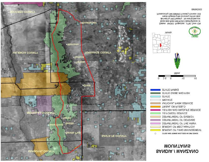
14 COMMUNITY PROTECTION COMMUNITY RANKING ZONES Western San Miguel Bernal M Western San Miguel Canoncito H Western San Miguel Cedar Hill L Western San Miguel East Las Vegas L Western San Miguel El Porvenir H Western San Miguel Gabaldon M Western San Miguel Gallinas H Western San Miguel Ilfeld H Western San Miguel Las Vegas L Western San Miguel La Manga M Western San Miguel Manuelitas H Western San Miguel Mineral Hill H Western San Miguel Montezuma H Western San Miguel North San Ysidro H Western San Miguel Pecos H Western San Miguel Pendaries Village H Western San Miguel Rociada H Western San Miguel Romeroville H Western San Miguel Rowe H Western San Miguel San Antonio M Western San Miguel San Miguel L Western San Miguel Sapello H Western San Miguel Sheridan H Western San Miguel Tecolote M Western San Miguel Tererro H Western San Miguel Tres Lagunas H Western San Miguel Upper Colonias H Western San Miguel Upper Rociada H Western San Miguel Villaneuva L Western San Miguel Winsor Creek H Sandia/Manzano Mts. Cedar Crest H Sandia/Manzano Mts. Chilili H Sandia/Manzano Mts. Manzano H Sandia/Manzano Mts. Mountainair M Sandia/Manzano Mts. Sandia Park H Sandia/Manzano Mts. Sedillo M Sandia/Manzano Mts. Tajique H Sandia/Manzano Mts. Tijeras H Sandia/Manzano Mts. Torreon H 14
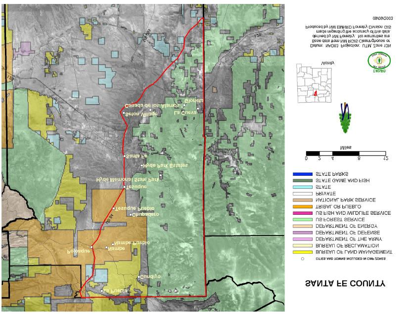
15 COMMUNITY PROTECTION ZONES COMMUNITY RANKING Santa Fe County Canada de los Alamos H Santa Fe County Chupadero M Santa Fe County Cundiyo M Santa Fe County Glorieta H Santa Fe County Hyde Park Estates H Santa Fe County Hyde State Park H Santa Fe County La Cueva H Santa Fe County La Puebla M Santa Fe County Nambe M Santa Fe County Nambe Pueblo M* Santa Fe County Pojoaque L Santa Fe County Santa Fe H Santa Fe County Seton Village H Santa Fe County Tesuque Pueblo H* Santa Fe County Tesuque H Zuni Mountains Bluewater M Zuni Mountains El Morro L Zuni Mountains Fort Wingate M Zuni Mountains Lobo Canyon (Grants) M Zuni Mountains McGaffey H Zuni Mountains Milan L Zuni Mountains Page L Zuni Mountains Pinehaven M Zuni Mountains Ramah M 15
16 APPENDIX 1 Southwest Region BIA ranking of tribal Communities at Risk Federal Register Tribal Priority Included in State Risk Assessment? Community Carrizo H No Cochiti Pueblo H Yes Dulce H No Elk H No Fort Wingate H No Isleta Pueblo H Yes Jemez Pueblo H No Mescalero H Yes Mount Taylor Game Ranch H No Nambe Pueblo M Yes Paguate M No Pescado L No Picuris Pueblo H No Pine Hill H No Pojoaque Pueblo M No Acoma Pueblo H No Laguna Pueblo H No San Felipe Pueblo H Yes San Ildefonso Pueblo H No San Juan Pueblo H Yes Sandia Pueblo H Yes Santa Ana Pueblo H Yes Santa Clara Pueblo H Yes Santo Domingo Pueblo H Yes Tamaya M No Taos Pueblo H Yes Tesuque Pueblo H Yes Three Rivers H No Whitetail H No Zia Pueblo H No Zuni Pueblo H No 16
17 APPENDIX 2 Step One: Convene Decision Makers Community Wildfire Protection Plan 1 Summary and Checklist Form a core team made up of representatives from the appropriate local governments, local fire authority, and state agency responsible for forest management. Step Two: Engage Interested Parties Contact and encourage active involvement in plan development from a broad range of interested organizations and stakeholders. Identify and engage local representatives of the USFS and BLM. Contact and involve other land management agencies as appropriate. Step Three: Establish a Community Base Map Work with partners to establish a baseline map of the community that defines the community s WUI and displays inhabited areas at risk, forested areas that contain critical human infrastructure, and forest areas at risk for large-scale fire disturbance. Step Four: Identify Problems to Be Addressed Work with partners to identify problems to be addressed, including fuel hazards; risk of wildfire occurrence; structural ignitability; local preparedness capability; and location of homes, businesses, essential infrastructure and other community values at risk. This community risk assessment can be simple or complex depending on the resources available to the community and partners. Step Five: Establish Community Priorities and Recommendations Use the base map and community risk assessment to facilitate a collaborative community discussion that leads to the identification of local priorities for fuel treatment, reducing structural ignitability, and improving fire response capability. Clearly indicate whether priority projects are directly related to protection of communities and essential infrastructure or to reducing wildfire risks to other community values. Step Six: Develop an Action Plan and Assessment Strategy Consider developing a detailed implementation strategy to accompany the CWPP, as well as a monitoring plan that will ensure its long-term success. Step Seven: Complete the Community Wildfire Protection Plan Consider the CWPP complete for the year and date stamp the document. Communicate the results to the community and partners. Collect information to update the plan for revision the following year. 1 This checklist was adapted from the publication Preparing a Community Wildfire Protection Plan: A handbook for Wildland-Urban Interface Communities that can be downloaded from The checklist was modified by the New Mexico Fire Planning Task Force for use in New Mexico. 17
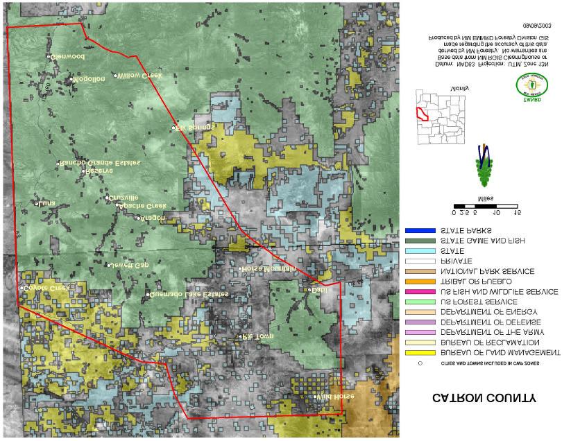
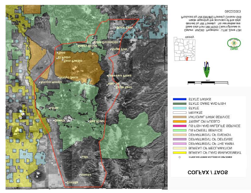
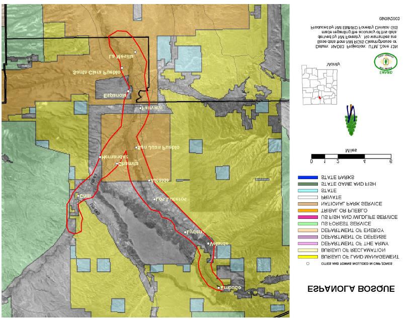
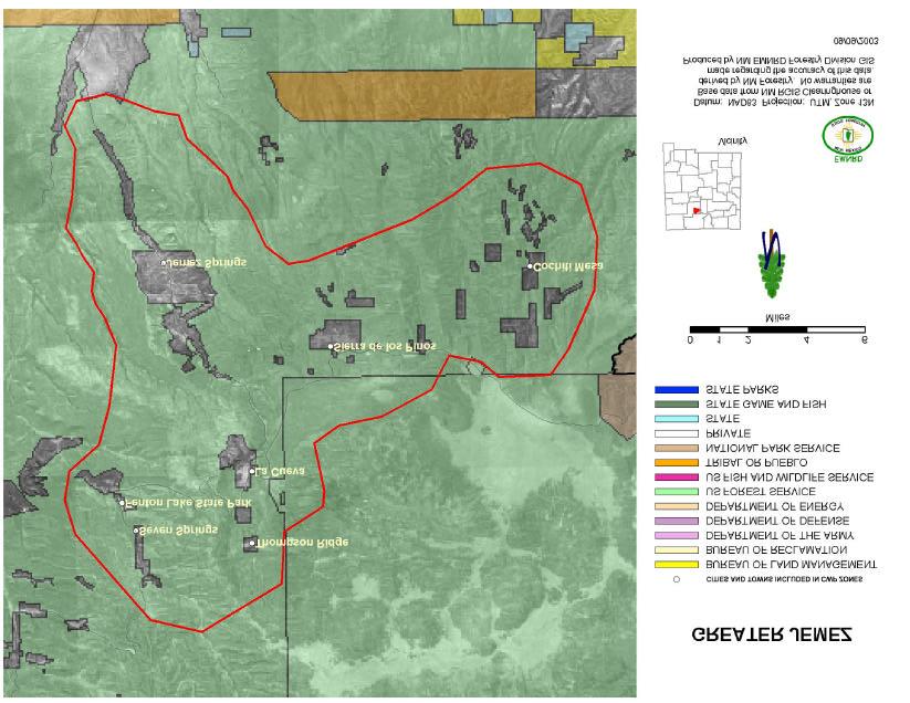
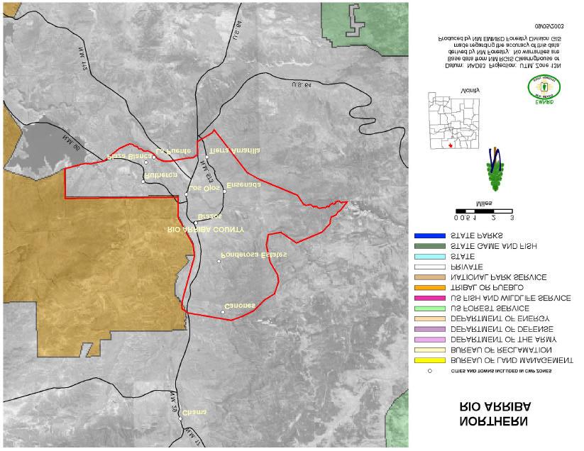
18 APPENDIX 3 New Mexico Community Protection Zone Maps Black Range Catron County Colfax/Taos Espanola Bosque Grant County Greater Jemez Los Alamos Magdalena Area Middle Rio Grande Bosque Mora County Otero County Raton Northern Rio Arriba County Greater Ruidoso Area Western San Miguel County Sandia/Manzano Mountains Santa Fe County Zuni Mountains 18
19 19
20 20
21 21
22 22
23 23
24 24
25 25
26 26

27 27
28 28
29 29
30 30
31 31
32 32
33 33
34 34
35 35
36 36
37 37
38 38
39 39
40 40
41 41
42 42
43 43
44 44
45 45
46 46
47 47
48 48
49 49
50 50
51 51
52 52
53 53
54 54
55 APPENDIX 4 * FIRE PLANNING ASSESSMENTS IN NEW MEXICO MEDIUM AND SMALL SCALE Area Funding source Completion Available at date Bernalillo County USFS-SPS7 6/ Catron County State/local 10/ Grant County USFS-SPS7 9/ City of Las Vegas FEMA 10/ Eight N. Pueblos USFS-SPS7? Los Alamos FEMA 5/2001 Mora County USFS-SPS7 6/ Otero County USFS-SPS7 9/ Raton/Colfax County USFS-SPS7 In progress Rio Arriba County USFS-SPS7 9/ Sandoval County USFS-SPS7 12/ San Miguel County USFS-SPS7 Fall 2003 Santa Fe County State/county 2/ Sierra County State/local 6/ Sierra Land Grant USFS-SPS7 9/ Torrance County USFS-SPS7 12/ Truchas Land Grant USFS-SPS7 9/ ADDITIONAL PLANS ADDRESSING FIRE HAZARDS IN NEW MEXICO Area Funding source Completion Available at date Catron Stewardship State 1/ Grant Stewardship State 4/ Hyde State Park WSFM 6/ N14 Stewardship WSFM 11/ S14 Stewardship WSFM 11/ State/local 1/ Save Our Bosque Task Force Action Plan * This information was originally presented in the 2004 Communities at Risk Plan 55
56 APPENDIX 5 REFERENCE LIST: Wildland/Urban Interface Fire Hazard Assessment Methodology. NWCG, undated (c.1997). A Collaborative Approach for Reducing Wildland Fire Risks to Communities and the Environment. 10-Year Comprehensive Strategy Implementation Plan. May FIELD GUIDANCE Identifying and Prioritizing Communities at Risk. National Association of State Foresters. June 2003 Preparing a Community Wildfire Protection Plan A handbook for Wildland-Urban Interface Communities. Society of American Foresters. March 2004 New Mexico Communities At Risk Assessment Plan Neskauskas et. al. April
zip Zipcode name City State County Name
 zip Zipcode name City State County Name 87510 ABIQUIU, NM ABIQUIU NM RIO ARRIBA 88310 ALAMOGORDO, NM ALAMOGORDO NM OTERO 88311 ALAMOGORDO, NM ALAMOGORDO NM OTERO 87101 ALBUQUERQUE, NM ALBUQUERQUE NM BERNALILLO
SPONSOR/EXHIBITOR INFORMATION & REGISTRATION
 SPONSOR/EXHIBITOR INFORMATION & REGISTRATION The 23 rd Annual New Mexico Infrastructure Finance Conference will be held October 24-26, 2018 at the Isleta Resort in Albuquerque, NM. Sessions have been selected
NATIONWIDE PERMIT ACTIONS JULY - SEPTEMBER Action Type Project Name Closure Method County State SPA SCO NWP River West Development
 DA Number Action Type Project Name Closure Method County State SPA-2013-00282- River West Development Chaffee CO SPA-2010-00457 Delbert Smith Conejos CO SPA-2010-00457 Delbert Smith Conejos CO SPA-2013-00379
SHELBY RANCH. unique places. Offered By: real estate
 SHELBY RANCH Offered By: SHELBY RANCH The Shelby Ranch is a great opportunity to acquire 702 +/- acres of northern New Mexico property that is less than 1.5 hours from Albuquerque and Durango and offers
Withdrawn Due To No Permit Required (NPR) Baca CO. Verified Without Special Conditions Chaffee CO. Verified Without Special Conditions Chaffee CO
 Baca CO. Verified Without Special Conditions Chaffee CO. Verified Without Special Conditions Chaffee CO") DA Number 00045-00057 NWP 00118 NWP 00477- NATIONWIDE PERMIT ACTIONS JAN - MAR 2013 Action Type Project Name End Date Railroad Bridge 190.22 Replacement, BNSF Railway Company, Two Butte Creek Tributary,
DA Number 00045-00057 NWP 00118 NWP 00477- NATIONWIDE PERMIT ACTIONS JAN - MAR 2013 Action Type Project Name End Date Railroad Bridge 190.22 Replacement, BNSF Railway Company, Two Butte Creek Tributary,
NATIONWIDE PERMIT ACTIONS APRIL - JUNE 2014
 DA Number 00385-LCO 00123 00124 00073 00075 00430 00043-SCO 00062-SCO 00062-SCO 00183-SCO 00195-SCO 00264-SCO 00272-SCO 00278-SCO 00282-SCO Action Type Name Closure Method County State Kingston Road and
ROCKHOUND MESA. unique places. Offered By: real estate
 ROCKHOUND MESA Offered By: unique places real estate ROCKHOUND MESA Now is your chance to purchase your very own mesa! Rockhound Mesa has it all. Sandstone rock galleries, ponderosa pine, cliffs, views,
North Central Regional Transit District. Quick Facts. Our Mission Statement:
 North Central Regional Transit District Our Mission Statement: The mission of the North Central Regional Transit District is to provide safe, secure and effective public transportation within North Central
2009 BOYS STATE TOURNAMENT March Albuquerque Class A P = University Arena (The Pit) 1 Cliff 58 S = Santa Ana Star
 1 Cliff 58 S = Santa Ana Star") Albuquerque Class A P = University Arena (The Pit) 1 Cliff 58 Wed 3-11 2:00 pm (B) Cliff 56 B = Bernalillo 8 Carrizozo 42 Thu 3-12 4:45 pm (S) Fort Sumner 67 4 Tatum 60 Wed 3-11 5:30 pm (B) Fort Sumner
Albuquerque Class A P = University Arena (The Pit) 1 Cliff 58 Wed 3-11 2:00 pm (B) Cliff 56 B = Bernalillo 8 Carrizozo 42 Thu 3-12 4:45 pm (S) Fort Sumner 67 4 Tatum 60 Wed 3-11 5:30 pm (B) Fort Sumner
Sulphur Creek Wetlands Restoration Project in the Valles Caldera National Preserve, Sandoval County, New Mexico
 DA Number Action Type Project Name Closure Method County State SPA-2015-00107-ABQ Sulphur Creek Wetlands Restoration Project in the Valles Caldera National Preserve, Sandoval County, New Mexico Sandoval
Knights ~ District Deputy 1, July. Page 1. District. Assigned Councils. Home Council. Name and Address. David Martinez 6212 Alzira NW
 Knights of Columbus New Mexico State Deputies for 2017 ~ 2018 Deputy Phone (s) 1 9105 12812 14452 David Martinez 6212 Alzira NW Albuquerque, NM 87114 505-359-4048 davidrmtz@hotmail.com 2 6696 7633 14999
Bernalillo Marketplace Shop Space
 JOIN Available: NEC Hwy. & NM 313 For Lease Suite 140-C Suite 180-B Suite 180-F Suite 180-H Lease Rate: $18.00 SF + NNN ($4.21/SF) Property Highlights: Fast-growing retail corridor in underserved market
NATIONWIDE PERMIT ACTIONS APR - JUN DA Number Action Type Project Name End Date Closure Method County State
 SPA-2008-00427-S Clear Creek ranch - stream restoration/enhancement -Clear Creek, Chaffee Co., 12-Jun-13 Chaffee SPA-2013-00127 Arkansas River Bank Stabilization Project at 352 and 354 East Sacket Avenue
Bernalillo Marketplace
 TURNKEY SALON JOIN Available: NEC Hwy. & NM 313 For Lease ±1,200 SF Turnkey Salon Lease Rate: $18.00 SF + NNN ($4.21/SF) Property Highlights: Fully built-out salon space 7 stations, 3 sinks, 1 bathroom,
PROVIDER SERVICES TERRITORY GRID 2017 CONTACT INFORMATION FOR
 PROVIDER SERVICES TERRITORY GRID 2017 CONTACT INFORMATION FOR Physical Health, Behavioral Health, Long Term Support Services PHYSICAL HEALTH PROVIDER SERVICE REPRESENTATIVES TERRITORY RESPONSIBILITIES
Organization Geographic Area Contact Phone # Address Address Site Location(s)
") Children, Youth, and Families Department List of Approved Domestic Violence Offender Treatment (DVOT) Providers CYFD will update the list to identify newly-approved providers and/or providers who have
Children, Youth, and Families Department List of Approved Domestic Violence Offender Treatment (DVOT) Providers CYFD will update the list to identify newly-approved providers and/or providers who have
Key Ham Repeaters for NM SAR Missions Published: 18 November 2012
 Key Ham Repeaters for NM SAR Missions Published: 18 November 2012 Police : 1 1-1 Pajarito Mt 145.190 -.600 none KD5CUC Los Alamos None 13 S 372147 3971695 1 1-2 Tesuque 146.820 -.600 162.2 W5SF Santa Fe
Knights ~ District Deputy 1, Page 1. July. Assigned Councils. Home Council. District. Name and Address. Vacant. Rio Rancho Bernalillo
 Knights of Columbus New Mexico State Deputies for 2017 ~ 2018 Deputy Phone (s) 1 9105 12282 12812 14452 2 6696 7633 14999 16122 Bernalillo Charles E. Hilger, Jr. P.O. Box 66252 Albuquerque, NM 87193-6252
PROVIDER SERVICES TERRITORY GRID 2017 CONTACT INFORMATION FOR
 PROVIDER SERVICES TERRITORY GRID 2017 CONTACT INFORMATION FOR Physical Health, Behavioral Health, Long Term Support Services PHYSICAL HEALTH PROVIDER SERVICE REPRESENTATIVES TERRITORY RESPONSIBILITIES
PROVIDER SERVICES TERRITORY GRID CONTACT INFORMATION FOR Physical Health Behavioral Health Long Term Support Services 2017
 PROVIDER SERVICES TERRITORY GRID CONTACT INFORMATION FOR Physical Health Behavioral Health Long Term Support Services 2017 PHYSICAL HEALTH PROVIDER SERVICE REPRESENTATIVES TERRITORY RESPONSIBILITIES Physical
Month to Month Comparison of Crash-related Fatalities. Fatalities. - Jan Feb Mar Apr May Jun Jul Aug Sep Oct Nov Dec
 New Mexico ly Traffic Fatality Report, Produced for the New Mexico Department of Transportation, Traffic Safety Division, Traffic Records Bureau, Under Contract No. 5801 by UNM Geospatial and Population
New Mexico Monthly Traffic Fatality Report, 2017
 New Mexico ly Traffic Fatality Report, 2017 Produced for the New Mexico Department of Transportation, Traffic Safety Division, Traffic Records Bureau, Under Contract No. 5801 by UNM Geospatial and Population
Month to Month Comparison of Crash-related Fatalities. Fatalities. - Jan Feb Mar Apr May Jun Jul Aug Sep Oct Nov Dec
 New Mexico ly Traffic Fatality Report, 2018 Produced for the New Mexico Department of Transportation, Traffic Safety Division, Traffic Records Bureau, Under Contract No. 5801 by UNM Geospatial and Population
Month to Month Comparison of Crash-related Fatalities. Fatalities. - Jan Feb Mar Apr May Jun Jul Aug Sep Oct Nov Dec
 New Mexico ly Traffic Fatality Report, 2018 Produced for the New Mexico Department of Transportation, Traffic Safety Division, Traffic Records Bureau, Under Contract No. 6093 by UNM Geospatial and Population
Representative Ben Ray Luján
 The 9 federally-funded health center organizations with a presence in New Mexico's 3rd Congressional District leverage $34,118,816 in federal investments to serve 155,459 patients. Utah 84 Colorado Kansas
Work Flows Into (CountyW)
") Counts of ers Commutg From New Mexico Counties 1 Each Flow Represents at Least.5 of All Trips Origatg the New Mexico County From () Into () endg endg Bernalillo Co. NM 261,708 Bernalillo Co. NM 243,949
Counts of ers Commutg From New Mexico Counties 1 Each Flow Represents at Least.5 of All Trips Origatg the New Mexico County From () Into () endg endg Bernalillo Co. NM 261,708 Bernalillo Co. NM 243,949
Key Ham Repeaters for NM SAR Missions Updated 11 June 2018
 1 1-1 Pajarito Mt 145.19-0.6 none KD5CUC Los Alamos None 13 S 372147 3971695 1 1-2 Tesuque 146.82-0.6 162.2 W5SF Santa Fe Other Linked 13 S 429358 3960277 SF Linked System - Tesuque, Elk Mt., St. Vincent
I-25/US24/Cimarron Street. Interchange Reconstruciton Special Conditions El Paso. Interchange Reconstruciton
 DA Number SPA-2014-00350- NATIONWIDE PERMIT ACTIONS JUL - SEPT 2014 Action Type Project Name Closure Method County State Pocket Wave Project, Buena Vista Whitewater Park, Arkansas River, Chaffee County,
Key Ham Repeaters for NM SAR Missions Updated 04 Oct. 2018
 Police District ID Name Frequency (MHz) Offset (MHz) Access Tone Callsign Located Near System UTM NAD27 Coords Comments 1 1-1 Pajarito Mt 145.19-0.6 162.2 W5SF Los Alamos None 13 S 372147 3971695 1 1-2
Verified With Special
 NATIONWIDE PERMIT ACTIONS OCT - DEC 2012 DA Number 00268-DR 00284- Action Type Project Name End Date NMDOT Reconstruction of US64, MP 60-62, West of Bloomfield, 18-Oct-12 Best, Acequia de la Otra Banda,
Closure Method County State Laguna Pueblo 404(F) Activity not. Activity not. Activity involve discharge into NONwaters.
 Activity not. Activity not. Activity involve discharge into NONwaters.") DA Number 00273-00291- 00295-00298- 00304- Action Type Project Name End Date Closure Method County State Laguna Pueblo Irrigation/Diversion Structure Maintenance, Seboyeta Creek, Cibola County 9-Jul-12
DA Number 00273-00291- 00295-00298- 00304- Action Type Project Name End Date Closure Method County State Laguna Pueblo Irrigation/Diversion Structure Maintenance, Seboyeta Creek, Cibola County 9-Jul-12
NATIONWIDE PERMIT ACTIONS JUL - SEP 2012
 DA Number 00188-00429 NWP NATIONWIDE PERMIT ACTIONS JUL - SEP 2012 Action Type Project Name End Date Closure Method County State Forest View Acres Water District, waterline crossing, Monument 12-Jul-12
WHERE WE VE BEEN. Dec 2016 Ra Paulette Cave Wilderness Shrines Las Vegas New Mexico Jan s on Fourth Cooking School Meow Wolf, Santa Fe
 WHERE WE VE BEEN Dec 2016 Nov 2016 Oct 2016 Sep 2016 Aug 2016 July 2016 June 2016 May 2016 Mar 2016 Feb 2016 Jan 2016 Nov 2015 Oct 2015 Sep 2015 Aug 2015 June 2015 Ra Paulette Cave Wilderness Shrines Las
Las Conchas Wildfire (NM):
:") Las Conchas Wildfire (NM): Progression, Management, and Context Kristen Honig Los Alamos National Laboratory July 24, 2012 LA UR 12 22538 Photo Credit: Kristen Honig Las Conchas Fire Background Fire Timeline/Summary
Las Conchas Wildfire (NM): Progression, Management, and Context Kristen Honig Los Alamos National Laboratory July 24, 2012 LA UR 12 22538 Photo Credit: Kristen Honig Las Conchas Fire Background Fire Timeline/Summary
Santa Cruz North Interior
 Santa Cruz North Interior The Santa Cruz North Interior planning area includes the area commonly referred to as the San Lorenzo Valley. The greatest amount of development occurs in the communities of Boulder
Santa Cruz North Interior
 Santa Cruz North Interior The Santa Cruz North Interior planning area includes the area commonly referred to as the San Lorenzo Valley. The greatest amount of development occurs in the communities of Boulder
El Dorado County COMMUNITY WILDFIRE PROTECTION PLAN Community Tab for AUBURN LAKE TRAILS FIRE SAFE COUNCIL ACTIVITIES
 El Dorado County COMMUNITY WILDFIRE PROTECTION PLAN Community Tab for AUBURN LAKE TRAILS FIRE SAFE COUNCIL ACTIVITIES Prepared for Inclusion in the: EL DORADO COUNTY FIRE SAFE COUNCIL Community Wildfire
Kiwanis International
 Page 1 of 7 Southwest 02 Division 2 K0003A Albuquerque NM 79 76 76 76 76 77 84 85 85 7.59 +6 K04781 Aztec NM 5 5 5 5 5 5 5 5 5 0.00 K147 Bloomfield NM 4 4 4 4 4 4 4 4 4 0.00 K08906 Coronado, Albuquerque
TREATY OF GUADALUPE HIDALGO. Exposure Draft
 GAO United States General Accounting Office January 2001 TREATY OF GUADALUPE HIDALGO Definition and List of Community Land Grants in New Mexico Exposure Draft GAO-01-330 Form SF298 Citation Data Report
Unit 13: La Entrada The Spanish Enter New Mexico
 Assessment Activities: Student Activity Sheet Activity 1. Matching Place Names Draw a line to connect the Spanish Place Name with its English definition. 1. Los Alamos a. mayor 2. Española b. the stream
San Mateo North - Coastal
 San Mateo North - Coastal The San Mateo North Coastal planning area covers the northwest portion of San Mateo County outside the cities of Half Moon Bay, El Granada and Moss Beach. The eastern boundary
LIHTC Properties in New Mexico's 3rd District LIHTC (1997 to. (Ben Ray Lujan - R) 2016) Source: HUD LIHTC Through 2016
 2016) Source: HUD LIHTC Through 2016") LIHTC Properties in New Mexico's 3rd District LIHTC (1997 to (Ben Ray Lujan - R) 2016) Source: HUD LIHTC Through 2016 nprofit Placed AZTEC PROPERTIES II 401 S PARK AVE AZTEC NM 87410 t 30 t EATON VILLAGE
LIHTC Properties in New Mexico's 3rd District LIHTC (1997 to (Ben Ray Lujan - R) 2016) Source: HUD LIHTC Through 2016 nprofit Placed AZTEC PROPERTIES II 401 S PARK AVE AZTEC NM 87410 t 30 t EATON VILLAGE
NEW MEXICO ATTRACTIONS
 Scenic beauty is the number one reason visitors come to New Mexico, the Land of Enchantment. The geological makeup includes high mountain ranges, desert terrain, great plains, marvelous canyons and of
Mid Region Metropolitan Planning Organization List Date: July 12, Cross Refrence List of TIP Projects by Project Title 1 of 15
 96.3 A301522 2nd St SW (Valle de Oro) Trail Phase 2 Prosperity Ave. Rio Bravo Blvd. County of Bernalillo ABQ Ride Bus Stop Facilities 431.5 TA00064 Improvements Wide ABQ Ride Bus Stop Facilities 431.6
New Mexico Legislators Guide To Rural Transportation
 New Mexico Legislators Guide To Rural Transportation Purpose: The purpose of this educational material is to increase legislative awareness of Regional Planning Organization (RPO) structure, jurisdiction,
Chapter 2: El Dorado County Characteristics and Demographics
 Chapter 2: El Dorado County Characteristics and Demographics 2.1 Geographic Area and Demographics El Dorado County comprises 1,805 square miles with over half of the area in the Eldorado National Forest
Mid Region Metropolitan Planning Organization List Date: December 27, Project Title From To Lead Agency Pend Amend
 3.4 A300604 Orthophotography 3 wide NMDOT D 3.. $50,000.00 3.5 A300605 Orthophotography 3 wide NMDOT D 3.. $50,000.00 3.6 A300606 Orthophotography 3 wide NMDOT D 3.. $50,000.00 6.6 A301121 I 25 & NM 6
Notice of Intent to Repatriate Cultural Items: U.S. Department of Agriculture, Forest
 This document is scheduled to be published in the Federal Register on 06/06/2013 and available online at http://federalregister.gov/a/2013-13461, and on FDsys.gov 4312-50 DEPARTMENT OF THE INTERIOR National
SHASTA WEST PLANNING AREA
 2016 SHASTA COUNTY COMMUNITY WILDFIRE PROTECTION PLAN SHASTA WEST PLANNING AREA Covering the communities of: Centerville Redding (west & downtown) Shasta I. PROPOSED PROJECTS A. THE PLANNING AREA SHASTA
New Mexico Department of Transportation Transit and Rail Division
 New Mexico Department of Transportation Transit and Rail Division FY 2018 Statewide Transit Application/RPO Prioritization and Budget Award Recommendation Meeting May 25, 2017 10:00 AM NMDOT, Transit and
Doña Ana School Road water infrastructure. New Mexico Colonias Infrastructure Fund Act Annual Report
 Doña Ana School Road water infrastructure New Mexico Colonias Infrastructure Fund Act 2014 Annual Report Introduction The Colonias Infrastructure Fund Board (CIFB) was established by the Legislature in
Guide to the Ezra Zubrow aerial photographs of the Rio Grande Pueblos, circa 1967
 Guide to the Ezra Zubrow aerial photographs of the Rio Grande Pueblos, circa 1967 Photo Lot 2010 13 SMITHSONIAN INSTITUTION National Museum of Natural History National Anthropological Archives 4210 Silver
Elementary Schools
 2014-2015 List is limited to schools with any grade KN through 4 that are operational in school year 2014-15. Proficiencies are from 2014 and are for 3rd grade only. Title I Alamogordo Public 567 30.3
Attachment O Verified Statement of Christopher Banet Page 1 of 7
 Attachment O Verified Statement of Christopher Banet Page 1 of 7 Attachment O Verified Statement of Christopher Banet Page 2 of 7 Curriculum Vitae Education Christopher Banet United States Department of
El Dorado County COMMUNITY WILDFIRE PROTECTION PLAN Community Tab for LAKEHILLS FIRE SAFE COUNCIL ACTIVITIES
 El Dorado County COMMUNITY WILDFIRE PROTECTION PLAN Community Tab for LAKEHILLS FIRE SAFE COUNCIL ACTIVITIES Prepared for Inclusion in the: EL DORADO COUNTY FIRE SAFE COUNCIL Community Wildfire Protection
WORKSHEET 1 Wilderness Qualities or Attributes Evaluating the Effects of Project Activities on Wilderness Attributes
 WORKSHEET 1 Wilderness Qualities or Attributes Evaluating the Effects of Project Activities on Wilderness Attributes Date: 3/7/2017 Roadless Area: Ruby South Description of Project Activity or Impact to
Walgreen's Pharmacy Walgreens Pharmacies (Albuquerque) Store# Address Intersection City Zip Phone# Fax#
 Store# Address Intersection City Zip Phone# Fax#") Walgreen's Pharmacy Walgreens Pharmacies (Albuquerque) 9336 2011 12th St. NW 12th St. & Indian School Albuquerque 87104 247-2353 243-3779 7351 4700 4th Street NW 4th Street & Griegos Albuquerque 87107
Walgreen's Pharmacy Walgreens Pharmacies (Albuquerque) 9336 2011 12th St. NW 12th St. & Indian School Albuquerque 87104 247-2353 243-3779 7351 4700 4th Street NW 4th Street & Griegos Albuquerque 87107
Alternative 3 Prohibit Road Construction, Reconstruction, and Timber Harvest Except for Stewardship Purposes B Within Inventoried Roadless Areas
 Roadless Area Conservation FEIS Summary Table S-1. Comparison of Key Characteristics and Effects by Prohibition Alternative. The effects summarized in this table A would occur in inventoried roadless areas
Trails and Towers El Camino Real and the Verde Power Line in Santa Fe County
 Devin Bent, p 1 of 6, December 16, 2016. Introduction Trails and Towers El Camino Real and the Verde Power Line in Santa Fe County El Camino Real begins in Mexico City and travels 1600 miles north entering
Steve Holdsambeck District Ranger Spring Mountains National Recreation Area
 EXHIBIT C1 TESTIMONY ON RESOURCE MANAGEMENT ACTIVITIES ON THE SPRING MOUNTAINS NATIONAL RECREATION AREA HUMBOLDT-TOIYABE NATIONAL FOREST FOR THE LEGISLATIVE COMMITTEE ON PUBLIC LANDS May 28, 2004 Steve
FOR SALE >> VACANT LAND. Albuquerque, PRESENTED BY: COLLIERS INTERNATIONAL TOM FRANCHINI, CCIM BILL ROBERTSON
 FOR SALE >> WEST FOR SALE >> MESA Albuquerque, West Mesa NM Vacant Land PRESENTED BY: BILL ROBERTSON LIC. #8433 SENIOR VICE PRESIDENT PRINCIPAL DIR +1 505 880 7050 CELL +1 505 263 6644 BILL.ROBERTSON@COLLIERS.COM
Backcountry Flying in New Mexico
 Backcountry Flying in New Mexico Larry Filener 1 Fly New Mexico! What is backcountry flying. What kind of aircraft do I need? Resources for backcountry flying. Who supports backcountry flying. Where to
HIGH COUNTRY L-BAR RANCH
 HIGH COUNTRY L-BAR RANCH Sandoval and mckinley counties N e w m e x i c o Jim Haworth, Ranch Team Lead Broker ~ 505-235-5236 3613 NMSR 528 NW, Ste. H, Albuquerque, NM 87114 505-792-3713 www.wwrealty.com
Map 1.1 Wenatchee Watershed Land Ownership
 Map 1.1 Wenatchee Watershed Land Ownership Map 1.1 Wenatchee Watershed Land Ownership The Wenatchee watershed lies in the heart of Washington state in Chelan County. Just larger than the state of Rhode
HIGHWAY 17 WILDLIFE and REGIONAL TRAIL CROSSINGS
 HIGHWAY 17 WILDLIFE and REGIONAL TRAIL CROSSINGS Agenda and Meeting Format 7:00-7:15 Welcome 7:15-8:00 Presentation 8:00-8:30 Open House 8:30 Recap 9:00 Conclusion 2 Meeting Goals: Introduce the project
NEW MEXICO. Acoma Pueblo. New Mexico
 New Mexico NEW MEXICO Acoma Pueblo Acoma Cibola County, New Mexico Pueblo of Acoma P. O. Box 309 Acomita, NM 87034 (505) 552-6604 Fax: 552-6600 Total area 378,114 acres Federal Trust 364,809 acres Tribally
Sands Motel 112 McArthur St, Grants, New Mexico 87020
 Sands Motel 112 McArthur St, Grants, New Mexico 87020 6565 Americas Pkwy NE Suite 200, Albuquerque, NM 87110 verify the subject offering as suitable for the intended use. Neither exp Realty LLC, it s agents
Subject to Sale, Withdrawal or Error
 We are proud to offer an exclusive listing on a ranch in a very highly desired part of Northeast New Mexico. This ranch truly expresses the long understood real estate requirements of location, location,
Airport. Appendix A REFERENCES AND PREPARERS
 Double Eagle II Airport Appendix A REFERENCES AND PREPARERS Appendix A REFERENCES AND PREPARERS REFERENCES The following documents and websites were utilized during the preparation of this Environmental
MEMO TO STATE PUBLICATION PROGRAM LIBRARIES June 2, 2005
 MEMO TO STATE PUBLICATION PROGRAM LIBRARIES June 2, 2005 All expenses paid! Digital Archive Training! - We are planning a late July meeting and training session here in Santa Fe for any libraries interested
Ocho Rios, Jamaica GEF-IWCAM AND IABIN INDICATORS MECHANISM WORKSHOP March TNC s Marine Protected Area Work.
 TNC s Marine Protected Area Work in the Caribbean GEF-IWCAM AND IABIN INDICATORS MECHANISM WORKSHOP 10-12 March 2008 Ocho Rios, Jamaica Caribbean Decision-Support System 3 years (2003-2006) $2.2 million
On Page 5, following the Planning Process subsection, insert the following: 2012 Committee members included:
 Appendix D: City of Happy Valley Addendum to the Clackamas County Natural Hazards Mitigation Plan 2012 Amendments and Update The Oregon Partnership for Disaster Resilience prepared this Appendix to the
1. NUMERIC SITE IDENTIFICATION SYSTEM NEW MEXICO TEXAS COLORADO UTAH ARIZONA NEVADA...
 1 Contents 1. NUMERIC SITE IDENTIFICATION SYSTEM... 3 2.0 NEW MEXICO... 3 3.0 TEXAS... 8 4.0 COLORADO... 10 5.0 UTAH... 11 6.0 ARIZONA... 11 7.0 NEVADA... 13 2 1. Numeric Identification System T he numeric
New Mexico's 19 Pueblos
 puroticorico New Mexico's 19 Pueblos Santa Fe, 3 Days Table of contents: Guide Description 2 Itinerary Overview 4 Daily Itineraries 6 Santa Fe Snapshot 12 1 Guide Description AUTHOR NOTE: New Mexico s
Final School Rank Report by Weighted NMCI, Sorted by District then Facility Name 6/20/2007
 474 Alamogordo (A) Academy Del Sol HS 21,177 23.44% 646 Alamogordo (C) Lacy Simms MS 9,940 8.61% 391 Alamogordo Alamogordo High 268,548 29.36% 163 Alamogordo Buena Vista Elem 38,884 45.93% 274 Alamogordo
NMAC AFFILIATE OFFICERS June 2014 June 2016
 NMAC AFFILIATE OFFICERS June 2014 June 2016 NMAC ADVISORY COUNCIL CHAIR NMAC EXECUTIVE DIRECTOR Gabriel Romero Steve Kopelman NMAC Vice President Ex-Officio Member Taos County Commissioner 444 Galisteo
COPYRIGHTED MATERIAL. The Best of Northern New Mexico. New Mexico s Pueblo tribes have one character who stands out among many as a
 1 The Best of Northern New Mexico New Mexico s tribes have one character who stands out among many as a symbol of the spirit of this state: the fun-maker, called by a variety of names, most notably Koshare.
New Mexico s Pueblo tribes have one character who
 THE BEST OF NORTHERN NEW MEXICO New Mexico s tribes have one character who stands out among many as a symbol of the spirit of this state: the fun-maker, called by a variety of names, most notably Koshare.
Pinellas County Environmental Lands
 Pinellas County Environmental Lands In addition to traditional parks and recreation facilities, Pinellas County owns and manages a system of environmental lands that provides specialized resource-based
Creating a User-Driven Long-Distance OHV Trail Through Partnering
 Joseph Raffaele Outdoor Recreation Planner U.S. Bureau of Land Management Yuma, Arizona Creating a User-Driven Long-Distance OHV Trail Through Partnering BLM is a multiple-use land management agency within
BACKCOUNTRY TRAIL FLOOD REHABILITATION PROGRAM
 BACKCOUNTRY TRAIL FLOOD REHABILITATION PROGRAM Backcountry Trail Flood Rehabilitation A June 2013 Flood Recovery Program Summary In June 2013, parts of Southern Alberta were devastated from significant
COPYRIGHTED MATERIAL INDEX. A (Albuquerque), 108
, 108") INDEX A (Albuquerque), 108 AAA (American Automobile Association), 126, 377 Abiquiu, 194, 196 198, 280 Abiquiu Reservoir, 280 Abo, 120 Abourezk Building (Raton), 293 ABQ Ride (Albuquerque), 80 ABQ Uptown
INDEX A (Albuquerque), 108 AAA (American Automobile Association), 126, 377 Abiquiu, 194, 196 198, 280 Abiquiu Reservoir, 280 Abo, 120 Abourezk Building (Raton), 293 ABQ Ride (Albuquerque), 80 ABQ Uptown
April 10, Mark Stiles San Juan Public Lands Center Manager 15 Burnett Court Durango, CO Dear Mark,
 Mark Stiles San Juan Public Lands Center Manager 15 Burnett Court Durango, CO 81301 Dear Mark, We are pleased to offer the following comments on the draft San Juan Public Lands Center management plans
Final Environmental Impact Statement for the Merced Wild and Scenic River. Comprehensive Management Plan, Yosemite National Park, Madera and Mariposa
 This document is scheduled to be published in the Federal Register on 02/26/2014 and available online at http://federalregister.gov/a/2014-04061, and on FDsys.gov DEPARTMENT OF THE INTERIOR 4312-FF NATIONAL
NMAC AFFILIATE OFFICERS June 2016 June 2018
 NMAC AFFILIATE OFFICERS June 2016 June 2018 NMAC ADVISORY COUNCIL CHAIR NMAC EXECUTIVE DIRECTOR Rebecca Long Steve Kopelman President Elect Ex-Officio Member Lea County Commissioner 444 Galisteo St. 226
Establishing a National Urban Park in the Rouge Valley
 STAFF REPORT ACTION REQUIRED Establishing a National Urban Park in the Rouge Valley Date: March 29, 2012 To: From: Wards: Reference Number: Executive Committee Deputy City Manager, Cluster B All p:\2012\cluster
Albuquerque & Santa Fe. Street Atlas
 Albuquerque & Santa Fe. Street Atlas If looking for a book Albuquerque & Santa Fe. Street Atlas in pdf form, then you've come to faithful website. We present utter option of this book in doc, DjVu, epub,
French Fire Recovery and Restoration Project Wilderness Resource Impact Analysis
 French Fire Recovery and Restoration Project Wilderness Resource Impact Analysis This Wilderness Resource Impact Analysis for the French Recovery and Restoration Project (Project) includes a review of
South Central Regional Transit District Update
 Update Update This presentation will provide an update to the work done by the South Central Regional Transit District (SCRTD) with communities to plan a regionally based transit system. Additionally,
This grand ranch, set in
 Gallo Creek Ranch This grand ranch, set in the magnificent foothills of the Sacramento Mountains, is a dream for the seasoned rancher. Set in the natural backdrop of rolling hills, endless canyons and
Preferred Recreation Recommendations Stemilt-Squilchuck Recreation Plan March 2018
 Preferred Recreation Recommendations Stemilt-Squilchuck Recreation Plan March 2018 Below are the recommended recreation ideas and strategies that package together the various recreation concepts compiled
SUNPORT SOUTH BUSINESS PARK
 SUNPORT SOUTH BUSINESS PARK IS A NEW 330 ACRE DEVELOPMENT WITH RAIL, INTERSTATE AND AIRPORT ACCESS IN ALBUQUERQUE, NEW MEXICO. WHATEVER YOUR INDUSTRIAL NEED IS, SUNPORT SOUTH DELIVERS. COLLIERS INTERNATIONAL
Yard Creek Provincial Park. Management Plan
 Yard Creek Provincial Park Management Plan Draft January 2010 Yard Creek Provincial Park Management Plan Approved by: telàlsemkin/siyam/chief Scott Benton Bill Williams Squamish Executive Director ation
Planning Wildlife Crossings in Canada's Mountain Parks SESSION: Highway Mitigation: new insights for practitioners
 Planning Wildlife Crossings in Canada's Mountain Parks ID95 SESSION: Highway Mitigation: new insights for practitioners Trevor Kinley, Project Manager Lake Louise Yoho Kootenay Field Unit, Parks Canada
Ciudad Perdida, Colombia Project Progress Report
 Ciudad Perdida, Colombia 2012 Project Progress Report Executive Summary 2012 was another successful and exciting year of progress in and around the site of Ciudad Perdida in the Santa Marta Mountains of
Phoenix Habitat Restoration Projects
 Phoenix Habitat Restoration Projects Spur Cross Ranch Cave Creek (Estergard) Regional Tree and Shade Summit March 9, 2010 Desert Riparian Ecosystems Healthy riparian areas like this once existed along
13.1 REGIONAL TOURISM ISSUES AND SUMMARY OF FINDINGS
 13 REGIONAL TOURISM T he County of Mariposa s recreation needs and facilities fall within two categories: regional tourism and local recreation. This Element focuses on regional tourism issues related
EAST VALLEY PARKWAY FOR SALE - RESIDENTIAL DEVELOPMENT OPPORTUNITY 3141 E. VALLEY PARKWAY ESCONDIDO, CA ACRE SITE $1,100,000
 3141 E. VALLEY PARKWAY ESCONDIDO, CA 92027-5219 3.31 ACRE SITE $1,100,000 OFFERING HIGHLIGHTS Valley High School Residential Development Opportunity Close to Frances Ryan Park & Multiple Schools Settled
2.0 Physical Characteristics
 _ 2.0 Physical Characteristics 2.1 Existing Land Use for the Project The site is comprised of approximately 114 acres bounded by Highway 101 to the north, the existing town of Los Alamos to the east, State
Dr. Melissa Grigione And Kurt Menke. Jaguar -Arturo. Jaguarundi -Arturo. Ocelot -Arturo. Caso. Caso. Caso
 Identifying Priority Conservation Areas in the U.S.- Mexico Border Region for America s Neotropical Cats, the Jaguar, Jaguarundi and Ocelot: An International Effort Dr. Melissa Grigione And Kurt Menke