Tumbler Ridge UNESCO Global Geopark
|
|
|
- Rosanna O’Connor’
- 5 years ago
- Views:
Transcription


1 Tumbler Ridge UNESCO Global Geopark TUMBLER RIDGE TO HOLE-IN-THE-WALL DRIVING TOUR
2 2
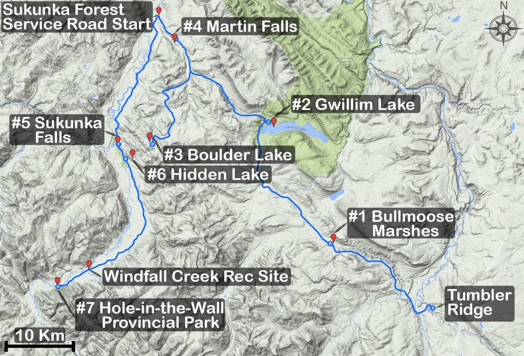
3 The one-way distance of this trip is 160 km if the recommended side trips are enjoyed. En route there are many attractions: a wetland hiking area, three lakes, two waterfalls, and a resurgence spring, with three provincial parks. These form the seven suggested stops described in this guide. Short hiking trails lead to most of these attractions. With the exception of Martin Falls, they lie within the Tumbler Ridge UNESCO Global Geopark. The drive from Tumbler Ridge to Hole-in-the-Wall involves 69 km of pavement on Hwy 29, then 52 km of unpaved road up the Sukunka Forest Service Road (FSR). The last 10 km are rough. There is no circular route option, so it is necessary to return to Tumbler Ridge the same way, or to head for Chetwynd (22.5 km away) when Hwy 29 is reached on the return journey. Hwy 29 and the Sukunka FSR pass through pleasant foothills scenery of the Hart Ranges of the Rocky Mountains. Hwy 29 northwest from Tumbler Ridge Zero your odometer at the junction of Hwy 29 and Mackenzie Way. Hwy 29 leaves Tumbler Ridge, crosses Flatbed Creek (beside the Lions Campground), the Murray River and the Wolverine River in quick succession. The Wolverine River is the site for evening lantern tours to dinosaur footprints offered in summer by the Tumbler Ridge Museum Foundation. The road crosses the bridge over Bullmoose Creek, then climbs, passing the turnoff to the Wolverine Forest Service Road. It ascends over a saddle, reaching an elevation of 1,126 m above sea level. It then descends into the Bullmoose Creek valley, and crosses the creek, after which there are signs for the first stop of the driving tour, Bullmoose Marshes. STOP # 1 BULLMOOSE MARSHES WETLAND AREA (Trail #14) Distance to turnoff from Tumbler Ridge: 24.5 km Distance off Hwy 29: 200 m (unpaved), then 900 m of trails The Sora Trail (250 m) and Bittern Trail (650 m) lead along boardwalks and trails to benches and viewing platforms overlooking this peaceful wetland and forest area with beaver dams. A bird checklist and trail brochure are available, and signs interpret the wetland habitats. 3

4 Viewing Platform at end of Sora Trail, Bullmoose Marshes Beyond Bullmoose Marshes Hwy 29 passes a turnoff to the left, which leads up the valley between Mt Spieker and Bullmoose Mountain to the Bullmoose Mine, which produced metallurgical coal from 1983 to Next there is a turnoff on the right for just over 5 km to the recreation site at Moose Lake, which is popular for fishing and camping. As Hwy 29 continues into the drainage of Meikle Creek and descends into a wide valley, the next large turnoff to the left leads to the Meikle Wind Project the huge wind turbines can be seen from the highway. Meikle Creek drains into Gwillim Lake, which is one of the bigger bodies of water in the region. STOP # 2 GWILLIM LAKE PROVINCIAL PARK (Park #5) Distance to turnoff from Tumbler Ridge: 45 km Distance off Hwy 29: 600 m to viewpoint, 2.5 km to lake shore (paved). It is worthwhile stopping at the viewpoint on the right 600 m after entering the park, where a large sign interprets the history and features of the lake and park. Gwillim Lake was named after J.C. Gwillim ( ), who conducted the first geological surveys in the region in Gwillim created the most accurate map at the time for what is now the Tumbler Ridge area, which included the first written mention of the name Tumbler Range. 4

5 Mt Meikle, the summit above the far shore of Gwillim Lake, is a mountain of sandstone left behind when softer shales were eroded away by ice and water after the formation of the Rocky Mountain foothills. The basin that was scoured out below Mt Meikle filled with water, forming Gwillim Lake, which is now 10 km long, with a maximum depth of 48 m. Twelve prehistoric First Nations sites have been identified along the shores of the lake. These sites typically contain lithic scatters, usually stone tools or the stone flakes created while producing these tools. Most are composed of regionally occurring quartzite or black chert, but flakes of basalt or obsidian are of volcanic origin and do not occur in the region. The obsidian likely originated on Mt Edziza, in the Coast Ranges of northwestern British Columbia. These discoveries imply significant trade patterns between First Nations. One site that contained burnt bone and charcoal was radiocarbon dated to 3500 years. Visitors are reminded that it is illegal to remove items, archeological or otherwise, from a provincial park. Canoeing on Gwillim Lake The horizon to the southwest is formed by Bullmoose Mountain. Its three summits and surrounding alpine slopes and cliffs are home to a herd of over 50 mountain goats. The highest of these summits is 2038 m above sea level. The rock layers visible from the viewpoint are from the Cretaceous Period. Rocks in the region are youngest in the northeast and oldest in the southwest. Those that form Bullmoose Mountain are of the Gates Formation and are just 5

6 over 100 million years old. They are older than those that form Mt Meikle on the south shore of Gwillim Lake. After you have enjoyed the viewpoint, proceed on down to the camping area and day use area on the shore of the lake. The Lakefront Trail (less than 1 km long, and rated easy) is a worthwhile short excursion. Gwillim Lake Day Use Area From the turnoff to Gwillim Lake, Hwy 29 continues northwest, over another saddle, and enters the Martin Creek valley. After 15 km there is a turnoff on the left to Boulder Lake. STOP # 3 BOULDER LAKE (Park #3) Distance to turnoff from Tumbler Ridge: 59.5 km Distance off Hwy 29: 17 km (unpaved), then 500 m easy trail The unpaved road winds through the Kwoen Hills, with occasional views of the mountains from logged areas. After 17 km there is a T junction. Turn right down a very steep road, park before a puddle in the road unless you have a good 4 x 4, walk past the puddle, and look for the trailhead on the right. The trail leads for 350 m past some large boulders to the peaceful lakeshore. Boulder Lake has a near-perfect rectangular shape, being over a kilometre 6

7 long and just 100 metres wide. The lake fills the trough of a syncline: note the angle of the rock layers that line the sides of the lake in places. The northwestern end of the lake is the source of Boulder Creek. Boulder Lake is ideal for fishing from the lakeshore or from a canoe or inflatable, portaged in from the trailhead. Boulder Lake STOP # 4 MARTIN FALLS (Trail #16) Distance to turnoff from Tumbler Ridge: 66 km Distance off Hwy 29: roadside parking, then a moderate trail of under 1 km The parking lot for Martin Falls is on the left side of the highway, 6.5 km from the turnoff to Boulder Lake and 21 km from the turnoff to Gwillim Lake. The hiking club in Chetwynd has done a great job of building a trail down into the canyon and to the falls (there are actually three successive waterfalls in Martin Canyon). From where the trail reaches the creek level it is an easy walk or boulder-hop upstream to the foot of the upper falls. Heading downstream along a spur trail or over bedrock leads to a viewsite of the middle falls, but caution should be used because of steep unprotected dropoffs. Martin Canyon is lined by rocks of the Dunvegan Formation (97 million years old), which were deposited in fresh water. Dinosaur tracks have been found in the canyon, and the rocks near the falls contain plant fossils. 7
.")
8 From the pullout for Martin Falls Hwy 29 continues down a long hill for just under 3 km, after which the Sukunka Forest Service Road enters from the left. Turn left here, 68.7 km from Tumbler Ridge. Martin Falls The Sukunka FSR is very busy with industrial traffic. This is a radio-controlled road, with instructions to call kilometres when driving back (north). Be prepared to pull over for large trucks. Reset your trip-meter to zero at the start of this road. There are reasonably accurate kilometre markers up to km 39. At km 12 there is a pleasant riverside stop beside a concrete structure, good for swimming in the deep pools beside the rocks. STOP # 5 SUKUNKA FALLS PROVINCIAL PARK (Park #4) Distance from Tumbler Ridge: 90 km Km 21 on Sukunka FSR Distance off Sukunka FSR: 250 m of steep, sometimes rough trails. Sukunka Falls Provincial Park preserves the wildest stretch of the river. A series of falls and rapids have viewpoints and there is a short hiking trail down to river level below the main falls, with offshoots to the rapids upstream and downstream. The river tumbles over successive parallel rock layers of the 8

9 Gething Formation from the Early Cretaceous Period (about 113 million years old), and the slightly older Cadomin Formation. The first pullout and parking area provide a good view of the falls, while the second, smaller pullout forms the trailhead. Autumn is a particularly good time, as the colours of the aspen are spectacular. One dinosaur footprint has been discovered just below the falls, where there is a small sandy beach. Sukunka Falls At km 22 there are further falls, which can be glimpsed through the forest, with a very faint trail that leads very steeply to river level. At km 24 there are rapids in the river which runs close to the road at this point, although there is no trail. STOP # 6 FROSLEY LAKE (HIDDEN LAKE) Distance from Tumbler Ridge: 94 km Km 25 on Sukunka FSR Distance off Sukunka FSR: 4 kilometre ATV route At km 25 there is a major turnoff left to a natural gas plant. A hundred metres along this side road, and before the entrance to the gas plant, lies the start of the trail to Frosley Lake, also known as Hidden Lake. This 4 km ATV route climbs steadily for a vertical gain of over 200 m, to reach the summit of a high 9

10 ridge. Hidden on the summit is a remarkable lake, which can be called Boulder Lake on steroids. Frosley Lake is 750 m long, and less than 75 m wide. Much of the shore is lined by steep cliffs of the Cadomin Formation, which dip at an angle of 80 degrees, forming a tight syncline. The lake fills this syncline and is very deep, and its shores are so straight and regular that it almost looks man-made. The trail emerges from the forest at the top of some of the highest cliffs. Here local daredevils, not content with jumping off the 10 m high cliffs into the lake below, have built an even higher jumping platform supported by trees. Frosley Lake (Hidden Lake) En route to Frosley Lake the trail passes a fine viewsite of the Sukunka Valley and surrounding mountains. While more suited to ATVs, the trail can also be used for hiking, mountain running, or difficult mountain biking. An ankylosaur dinosaur hand print was discovered right on the ATV trail. The Sukunka FSR continues up the valley, with a number of side roads that lead to industrial sites. Continue straight at all these junctions. Kilometre signs become less frequent after km 39, and the road progressively becomes less maintained. At km 42 there is private land on the right, after this point the road needs to be driven slowly and with caution to avoid potholes. It can be driven 10
11 without 4WD when conditions are dry, although moderately high clearance is required. Just before km 46 is the pleasant Windfall Creek Forest Recreation Site, with a few rustic campsites, fire rings and picnic tables. Just beyond this, after crossing the creek, the road verges on a nice stretch of river. The worst patch of road is a badly rutted, wet section at km 49. For those who make it this far, reaching and enjoying Hole-in-the-Wall is well worth the effort. STOP # 7 HOLE-IN-THE-WALL PROVINCIAL PARK Distance from Tumbler Ridge: 119 km Km 52 on Sukunka FSR Distance off Sukunka FSR: 50 m trail Here a substantial clear stream emerges at the foot of a vertical blue-grey limestone cliff, and flows through the forest surrounded by lush vegetation. The creek flows beneath the road after 40 m. Driving up the Sukunka valley into the mountains, progressively older rock layers are encountered. The limestone cliff is from the Mississippian Period, between 359 and 323 million years old. In some other parts of the world rocks of this age contain the remains of ancient forests, and have yielded abundant coal resources. By contrast, rocks of this age in the Tumbler Ridge UNESCO Global Geopark were formed from sediments deposited on the floor of a balmy, shallow sea, about 20 north of the equator, off the shore of the continent of Laurentia. Water in which carbon dioxide is dissolved forms the weakly acidic carbonic acid, which can dissolve limestone rock. Surface water is rare in such areas, and most water drainage occurs through tunnels and channels in the rock deep underground. At the bottom of the limestone rock layer, if the underlying rocks are impermeable to water, this water may travel along the upper surface of the impermeable rock until it reaches the surface as a spring. Holein-the-Wall is an outstanding example of such a resurgence spring. Flow rates are higher in spring but remain considerable throughout the year. A pair of American Dippers can be often be seen bobbing up and down on the rocks in the creek, or foraging in the water. They usually nest right above the spring in the rock cliff in June and July. Please do not disturb these birds when nesting. 11


12 Hole-In-The-Wall Resurgence Spring Having come this far up the valley, it may be worthwhile continuing another 4 km up the Sukunka FSR to where it crosses the river, beside an attractive wilderness camping area. The Sukunka FSR goes much further into the mountains, but this is a remote area and the road deteriorates even further. For intrepid adventurers there is a combination of excellent scenery, remote alpine lakes and mountain summits, caves, and such choice destinations as Burnt River Falls, Burnt River Cave, and the railway tunnels at the headwaters of the Sukunka River. Photo Credits: Charles Helm, Birgit Sharman, Recreation Sites and Trails BC 2017 Wolverine Nordic and Mountain Society 12
Tumbler Ridge Global Geopark
 Tumbler Ridge Global Geopark WILDERNESS WATERFALLS These waterfalls are in remote locations, no trails exist, and GPS is required. Not every geosite needs a hiking trail. Providing ready access to all
beach. Make the ford and follow the trail out to the junction with Red Creek Tr in an open grassy area.
 Description: This is a moderate to slightly strenuous 22.8 mile backpack (add 2.6 miles if you do the packless out and back to the Lion s Head) that will have you exploring nearly every thing that is The
Sponsorship Package. [Type text] Sponsor Inquiries: John Powell District of Tumbler Ridge (P): (E):
![Sponsorship Package. [Type text] Sponsor Inquiries: John Powell District of Tumbler Ridge (P): (E):](/thumbs/85/92262239.jpg "Sponsorship Package. [Type text] Sponsor Inquiries: John Powell District of Tumbler Ridge (P): (E):") [Type text] Sponsor Inquiries: Sponsor Inquiries: John Powell District of Tumbler Ridge (P): 250-242-4246 (E): coalforum@dtr.ca Stephanie Rowe (P): 250-242-4246 (E): coalforum@dtr.ca Dear Friend of the
[Type text] Sponsor Inquiries: Sponsor Inquiries: John Powell District of Tumbler Ridge (P): 250-242-4246 (E): coalforum@dtr.ca Stephanie Rowe (P): 250-242-4246 (E): coalforum@dtr.ca Dear Friend of the
Rogue Gorge (Mt. Stella) Roadless Area-- T30S R3E (primarily in portions of Sections 23, 26, 33, 34 & 35)
 Roadless Area-- T30S R3E (primarily in portions of Sections 23, 26, 33, 34 & 35)") Rogue Gorge (Mt. Stella) Roadless Area-- T30S R3E (primarily in portions of Sections 23, 26, 33, 34 & 35) Rogue River-Siskiyou National Forest--High Cascades Ranger District Upper, higher elevation trail
Rogue Gorge (Mt. Stella) Roadless Area-- T30S R3E (primarily in portions of Sections 23, 26, 33, 34 & 35) Rogue River-Siskiyou National Forest--High Cascades Ranger District Upper, higher elevation trail
playwinterpark.com Off The Beaten Path Hikes Hiking Recommendations for the Adventurous Hiker
 playwinterpark.com Off The Beaten Path Hikes Hiking Recommendations for the Adventurous Hiker Hike: Devil s Thumb (difficult) Length: 3.93 miles one-way Elevation: Trailhead 9609 Destination 12,236 Trailhead
Trail Phasing Plan. Note: Trails in the Clear Creek Canyon area (Segments will be finalized in the future to minimize wildlife impacts
 Note: Trails in the Clear Creek Canyon area (Segments 2 5 and a future JCOS connection) will be finalized in the future to minimize wildlife impacts Trail Phasing Plan P Parking 3 Easy Trail Intermediate
Location: Height: Access: Distance: Elevation: Season: Difficulty: Lat/Long: Directions:
 Upper Eagle Falls Upper Eagle Falls (~20 ft.) is a short hike up from the roadside at the Eagle Falls picnic area. It is very difficult to get a parking spot here during the day, so it is recommended to
Lava Mountain Trail Distance: Elevation Range: Trail Type: Difficulty: Season: Driving Distance: Driving Time: USGS Maps: Pros Cons
 Lava Mountain Trail Distance: 13.4 miles (including the side trip to North Star Lake) Elevation Range: 5900'-8330' Trail Type: singletrack Difficulty: moderate Season: late June-October Driving Distance:
CRAZY HORSE TRAIL GUIDE
 CRAZY HORSE TRAIL GUIDE Abridged Version: July 2016 This is a short form of our interpretive trail guide for the Crazy Horse Trail. The full version of the guide has a more detailed description of the
GIFFORD PINCHOT NATIONAL FOREST
 GIFFORD PINCHOT NATIONAL FOREST 9341 Wright Meadow 93 Spencer Meadow Spencer Butte 4247' 30 30A 19 24 80 31C Lewis River Lower Falls 5 Quartz Creek 90 Taidnapam Falls Upper Falls 31 Spencer Peak 3861'
HOLE IN THE WALL PROVINCIAL PARK
 HOLE IN THE WALL PROVINCIAL PARK PURPOSE STATEMENT AND ZONING PLAN Peace Region 2006 Approved by: Andy Ackerman, Regional Manager Environmental Stewardship Division Peace Region Date: 2006 Nancy Wilkin
Route #2) Mt. Massive - Southwest Slopes
 Mt. Massive - Southwest Slopes") Route #2) Mt. Massive - Southwest Slopes Difficulty: Class 2 Ski: Advanced, D6 / R2 / III Exposure: Summit Elevation: Trailhead Elevation: Elevation Gain: Round-trip Length: Trailhead: County Sheriff:
Route #2) Mt. Massive - Southwest Slopes Difficulty: Class 2 Ski: Advanced, D6 / R2 / III Exposure: Summit Elevation: Trailhead Elevation: Elevation Gain: Round-trip Length: Trailhead: County Sheriff:
Driving Time: 3 hours (allow extra time for stops)
") Scenic Byways loop This journey takes visitors through the eastern edge of Mt. Rainier National Park and along two of Washington s most beloved scenic byways, the Chinook Byway and the White Pass Scenic
Scenic Byways loop This journey takes visitors through the eastern edge of Mt. Rainier National Park and along two of Washington s most beloved scenic byways, the Chinook Byway and the White Pass Scenic
155 acres on Tyaughton Lake 900 feet of Pristine Waterfront Private & Secluded Property
 155 acres on Tyaughton Lake 900 feet of Pristine Waterfront Private & Secluded Property 946 Tyaughton Lake Road Gold Bridge BC V0K1P0 900 ft of waterfront with 155 acres of south facing easy access. This
Piestewa Peak/Dreamy Draw Trail Guide
 Piestewa Peak/Dreamy Draw Trail Guide Trail #1A - Perl Charles Memorial Trail Length: 4.8 miles Elevation: 2,200 ft. - 1,340 ft. Difficulty: Moderate to difficult The Perl Charles trailhead is located
CIEC 9 PEAKS AWARD SUPPLEMENT POSSIBLE ROUTES FOR THE 9 PEAKS AWARD TRIP
 CIEC 9 PEAKS AWARD SUPPLEMENT POSSIBLE ROUTES FOR THE 9 PEAKS AWARD TRIP As you plan your trip, be aware of 3 regulations in this wilderness: 1. Camp only in designated campsites. 2. No campfires allowed.
Crystal Lake Area Trails
 Lake Area Trails Welcome to the Lake area of the Big Snowy Mountains! This island mountain range in central Montana features peaks reaching to 8,600 feet and long, high ridges from which vistas of the
Erskine Creek via Pisgah Rock and Jack Evans
 Erskine Creek via Pisgah Rock and Jack Evans 4 hrs 30 mins 7.1 km Circuit Very experienced only 6 421m This walk visits some great lookouts and explores the lower section of Erskine Creek. Most of the
Kitimat. Pacific Inland Coast. Hiking Guide Kitimat, British Columbia, Canada
 Kitimat Pacific Inland Coast Hiking Guide Kitimat, British Columbia, Canada 2010-2011 Sites and Trails Emergency Call 911 Police - Fire - Medical 2 Welcome to Kitimat This information was produced to assist
HIKING IN THE CANADIAN ROCKIES
 HIKING IN THE CANADIAN ROCKIES Distance Time Elevation y MORAINE LAKE TRAILS THE ROCKPILE 0.8 km (0.5 mi) 20 min 30 m (98 ft) Located adjacent to the Lodge, the short interpretive trail up the Rock Pile
Skiing and Snowshoes on Un-groomed Fernan Saddle Terrain
 Skiing and Snowshoes on Un-groomed Fernan Saddle Terrain Three ski or snowshoe routes are available from the Fernan Saddle Parking Lot which either do not cover routes ordinarily groomed for snow machine
Photographing Upper Peninsula Waterfalls
 Photographing Upper Peninsula Waterfalls Tod Poirier Freelance Photographer Photography is one of my passions. The following spread showcases several Upper Peninsula waterfalls. At times a single drop
Arches of the. Sandflats Area. By Virginia Allen
 Arches of the Sandflats Area By Virginia Allen TABLE OF CONTENTS Introduction Dedication Road Log Arches 1. Perforated View Arch 2. Fee Booth Arch 3. Windsong Arch 4. Weird Arch 5. Resting Arch 6. Bike
MONKMAN PASS MEMORIAL TRAIL
 MONKMAN PASS MEMORIAL TRAIL DRIVING TOUR CAUTION In 2009 over half of the driving tour is still on unpaved, sometimes rough roads, and therefore not always suitable for motor homes or small vehicles. But
Mountain Footsteps. Photo: Ric Carless
 ho: Ric Carless Road Directions Middle White River FS Roads Deep Lake and Driftwood Lake see page 101, Connor Lakes along Maiyuk Creek see page 105, and for access Top of the World rovincial ark see page
Non-motorized Trail Plan & Proposal. August 8, 2014
 Town of Star Valley Ranch, Wyoming and the Star Valley Ranch Association in partnership with the USDA Forest Service, Bridger-Teton National Forest, Greys River Ranger District Non-motorized Trail Plan
CWMGIEDD FROM ABERCRAVE
 Abercrave to Cwmgiedd Walk Page 1 Starting from The Abercrave Inn. Grid Ref: SN 824128 From the Abercrave Inn, an 11.3km (7 miles) walk to the foothills of the Cribarth Mountain, then through forest to
APPENDIX 19-II. Ontario Trail Network Trailheads EAST-WEST TIE TRANSMISSION PROJECT AMENDED ENVIRONMENTAL ASSESSMENT REPORT
 EAST-WEST TIE TRANSMISSION PROJECT AMENDED ENVIRONMENTAL ASSESSMENT REPORT APPENDIX 19-II Ontario Network heads Report. 1536607/2000/2219 Ontario Network heads in the n-commercial Land and Resource Use
Trekking at Peuma Hue
 Trekking at Peuma Hue Peuma Hue is a paradise for those who love hiking and trekking. A large variety of trails cross pristine forest, ancient rocks and stunning waterfalls with beautiful views over the
Note: Coordinates are provided as Universal Transverse Mercator UTM Zone U21, North American Datum 1983 (NAD 83).
.") Northern Traverse Route Description The Northern Traverse (formerly the North Rim Traverse) is an unmarked and rugged backcountry hiking route. It is known be a demanding hike, because of its terrain and
Northern Traverse Route Description The Northern Traverse (formerly the North Rim Traverse) is an unmarked and rugged backcountry hiking route. It is known be a demanding hike, because of its terrain and
Logan Canyon Hiking Trail Guide
 C a c h e V a l l e y V i s i t o r s B u r e a u Logan Canyon Hiking Trail Guide Monique Beeley Legend Trail Location Guide WASATCH CACHE NATIONAL FOREST WILDERNESS PAVED WATER TRAILHEAD 9 Logan River
Skyline Drive Hogback Canon City
 Skyline Drive Hogback Canon City Direction to trailhead: From US 50, turn north onto 15th Street. At the traffic circle, continue north on 15th Street until it dead ends at Washington Street (about 1.5
Androscoggin River Trail Access Sites. North Woods. 168 miles from its source at Lake Umbagog to Merrymeeting Bay
 Androscoggin River Trail Access Sites North Woods 168 miles from its source at Lake Umbagog to Merrymeeting Bay Trail Under Construction More than 40 Public Access Sites Available Androscoggin River Watershed
Hiking Las Vegas.com
 Hike: Mt. Wilson via First Creek Canyon route Trailhead: First Creek marked Distance: 10 miles up and back Elevation gain: 3,400 feet Elevation of Peak: 7,070 feet Time: 7 to 9 hours (up and back) Difficulty:
The striking colours of the setting sun reflecting on the waters is how Crimson Lake received its name. Crimson Lake Provincial Park is a meeting
 The striking colours of the setting sun reflecting on the waters is how Crimson Lake received its name. Crimson Lake Provincial Park is a meeting place of foothills forests in the west, bog and muskeg
Dadder Cave and Jack Evans track
 Dadder Cave and Jack Evans track 2 Days 10.3 km Circuit Very experienced only 535m This fairly short overnight walk is a great way to explore Erskine Creek. The walking along Erskine creek is mostly off
Telluride-to-Moab Alternative Singletrack Options
 Telluride-to-Moab Alternative Singletrack Options Day 1 Day 1 Alternate 1: Galloping Goose to Deep Creek. 18.4 miles, ascent 3,530ft, descent 1,388ft. This is fun, flowey, moderate to intermediate singletrack
Berowra Waters to Cowan Station
 Berowra Waters to Cowan Station 3 hrs 30 mins 7.2 km One way Hard track 597m This is a hilly walk out of the beautiful Berowra Waters valley to Cowan Station. There are many wide views across Berowra Creek
GOLDEN EARS PROVINCIAL PARK
 GOLDEN EARS PROVINCIAL PARK Trail Information as of October 10 th 2015 Do not underestimate the mountainous wilderness of Golden Ears Provincial Park. The combination of rugged terrain and rapidly changing
HIKING/BIKING IN MERRITT AREA
 HIKING/BIKING IN MERRITT AREA Coquihalla Lakes: Just inside the southern boundary of BC Park's Coquihalla Summit Park, a nice little twin lakes paddle with a private campground & lodge is the Coquihalla
(west) onto Charleston Boulevard. Drive 16 miles on Charleston and turn right into Red Rock
 onto Charleston Boulevard. Drive 16 miles on Charleston and turn right into Red Rock") Hike: North Peak and Ice Box Overlook up and back Trailhead: 2.5 miles up the Rocky Gap Road not mark Distance: 5 miles round trip Elevation gain: 2,694 feet Elevation Peak: 7,094 feet Time: 3 to 5 hours
Hike: North Peak and Ice Box Overlook up and back Trailhead: 2.5 miles up the Rocky Gap Road not mark Distance: 5 miles round trip Elevation gain: 2,694 feet Elevation Peak: 7,094 feet Time: 3 to 5 hours
ITINERARY OUTLINE FOR BESPOKE TRIPS
 TREK GRAND CANYON 1 ITINERARY OUTLINE FOR BESPOKE TRIPS DAY 1 DEPART / ARRIVE LAS VEGAS We arrive into Las Vegas and transfer 30 minutes directly to our Boulder City hotel with our local team. This evening
Lake Wissota Access Locations within the LaFayette Township. By Chad Martin
 Lake Wissota Access Locations within the LaFayette Township By Chad Martin Anson/ Wissota Access Point # 1 Road: 195 th St. Associated Fire Numbers: 13294 Defining Characteristics: Forested from road
C E N T R A L C A T S K I L L S
 120 C E N T R A L C A T S K I L L S Central Catskills Once out of the southern parts of the Catskills, the Long Path enters the more well traveled and civilized regions. The trail joins the Devil s Path,
Listing of Campsites on the Manigotagan River
 Listing of Campsites on the Manigotagan River This document lists and describes the campsites along the Manigotagan River between Highway #314 and the government dock in the community of Manigotagan. The
Delaware Wildlife Area
 Delaware Wildlife Area 8 miles away from Delaware 4,670 acre Wildlife Area 1) Take Rt. 36/East Williams Street eastward 2) Take left onto Rt. 42/Lake Street 3) Slight left onto Horseshoe Rd./CR. 220 4)
Mountain Goats and Winter Recreation November 17, 2011
 Mountain Goats and Winter Recreation November 17, 2011 Summary Mountain goats need protection from disruption and displacement in their winter feeding areas by motorized and non-motorized recreationists
Mt Kuring-gai Track to Berowra station
 Mt Kuring-gai Track to Berowra station 4 hrs 15 mins 9.7 km One way Hard track 4 553m This walk explores three valleys, with great displays of wild flowers in spring, and some nice sandstone overhangs.
BULLET CANYON - GRAND GULCH
 BULLET CANYON - GRAND GULCH Rating: Long Dayhike / Easy Backpack Length: 7-10 hours Gear: Standard Hiking Gear Maps: Cedar Mesa North, UT; Pollys Pasture, UT Water: Several Spring in Bullet and at the
Pocahontas Area Map Jasper INFORMATION CENTRES Lake Louise Field Golden Banff
 Pocahontas Miette Hot Springs Area Map Jasper Maligne JASPER Columbia Icefield Saskatchewan River Crossing INFORMATION CENTRES Banff National Park Louise Kootenay Park Lodge Yoho National Park Columbia
Dnigi Hut. Dnigi is Dnaina for Moose. Location:
 Dnigi Hut in places. Stay on the main thoroughfare. Continue along the ridge top, going east to a pass above Knob Creek. Just beyond here look for a left turn which descends north-northwest (61,45.578,-148,52.414,2081
Evaluation of Outstanding Remarkable Values for Collawash River March 2011
 Evaluation of Outstanding Remarkable Values for Collawash River March 0 Segment From headwaters of East Fork Collawash River to Buckeye Creek Mileage: miles Free flowing: Yes Scenic:, Substantial River
Ribbon Cliff - Ribbon Mesa text and photos by Charlie Hickenbottom
 Ribbon Cliff - Ribbon Mesa text and photos by Charlie Hickenbottom Looking for something a little different than Sage Hills or Saddlerock? Perhaps something a little wilder, a little less traveled? Look
Figure 1 Understanding Map Contours
 Figure 1 Understanding Map Contours The light brown lines overprinted on topographic maps are called contour lines. They indicate the elevation above sea level of land features and thus permit you to view
UTAH S NATIONAL PARK TOUR
 UTAH S NATIONAL PARK TOUR DAY 1 Each client needs to check in any time at the fabulous Aria Hotel located in the heart of Las Vegas. We will meet at 6pm for a one hour orientation explaining the schedule
Bryce Canyon Country ATV Multi-Day Itinerary
 Bryce Canyon Country ATV Multi-Day Itinerary Look for more trail information and maps on these web-sites listed below. www. Casto Canyon Kick off your ATV adventure with this 36 mile round-trip ride through
S H A W A N G U N K R I D G E T R A I L
 214 Shawangunk Ridge Trail The Shawangunk Ridge Trail was originally conceived as a relocation of the Long Path from Harriman State Park to Minnewaska State Park. Now part of the Long Path system, the
Hiking Trail Descriptions
 Hiking Trail Descriptions For ye shall go out with joy. And be led forth with peace. The mountains and the hills shall break forth before you in singing. And all the trees of the fields shall clap their
CRANBERRY. Introduction
 Introduction Introduction The Cranberry Boulders are a group of 60 problems set in a beautiful mossy forest above the Cranberry Creek. The boulders are located approximately 36km south of Revelstoke on
Best Hikes on Orcas Island
 Published on San Juan Islands Washington Visitors Bureau Orcas Island Lopez Island Friday Harbor San Juan Island (https://www.visitsanjuans.com) Best Hikes on Orcas Island The Emerald Isle offers big trees,
Beautiful Walks from the Blue Ball Inn
 Walk No. 5 RIVER VALLEYS AND MOOR Countisbury, Watersmeet, Hillsford Bridge, Cheriton, Shilstone Hill, Rockford and Chiselcombe. 8.5 MILES APPROX. Walking time four and a half hours approx. OS 1;25,000
Hike at Pico Blanco Labor Day Weekend!
 Hike at Pico Blanco Labor Day Weekend! The Pico Blanco Hymn Here among the trees majestic Pleasures you will find On the trails of Pico Blanco With your friends and mine Trail the Eagle ever onward This
Garibaldi Provincial Park Trail Conditions
 Garibaldi Provincial Park s August 2, 2018 Garibaldi Park is located in the coast mountain wilderness and the weather can be severe and unforgiving. Be well prepared, properly equipped and informed before
APPENDIX C LIST OF OTHER PARK SYSTEMS WITHIN THE PRRD
 APPENDIX C LIST OF OTHER PARK SYSTEMS WITHIN THE PRRD The PRRD is well served with parks of various kinds and levels within its boundaries. Although there are no national parks within the PRRD, there is
Exploring the Dumaresq River
 Exploring the Dumaresq River The Dumaresq River (dew merrick) lies on the western side of the Great Dividing Range, the continuous line of mountains that flanks the entire east coast of Australia. The
HAVE A GREAT HIKE AND ENJOY!
 BAKER LAKE HIKE #5634 & #234 (Moderate to Strenuous walking sticks recommended) DIRECTIONS TO TRAILHEAD: From Triple Creek s driveway, turn left on West Fork Road and drive about 1.3 miles (just past mile
Asheville & WNC Hikes
 Asheville & WNC Hikes Amazingly, we have 3,000+ miles of free public hiking trails near Asheville, including 1,600 miles in the Pisgah and Nantahala National Forests, 850 miles in Great Smokey Mountains
Located in the northeastern part of WA, the Gibb River Road is ready for adventure. Photo: Aaron Schubert
 Australia has some world class camping destinations, and the Gibb River Road in the northern part of Western Australia is a prime example of this. Located in the Kimberley, the Gibb River Road is a spectacular
Self-Guided Walk Langdale Pikes. Start & Finish: NT car park (free to members) at Sticklebarn - on the right just beyond the New Dungeon Ghyll hotel.
 at Sticklebarn - on the right just beyond the New Dungeon Ghyll hotel.") Self-Guided Walk Langdale Pikes Key Information These mountains form a collection of spires and cliffs on the north side of Langdale. This walk visits four of the main tops Pavey Ark, Harrison Stickle,
Self-Guided Walk Langdale Pikes Key Information These mountains form a collection of spires and cliffs on the north side of Langdale. This walk visits four of the main tops Pavey Ark, Harrison Stickle,
Glacial Geomorphology Exercise
 James Madison University Field Course in western Ireland Glacial Geomorphology Exercise 3-day road log (abbreviated) Striations Large kame terrace Cirque with moraines Kame delta Striations Eskers Raised
1. Drive to Lake Cowichan via Highway 18 (which connects to the Trans-Canada Highway just north of Duncan)
") Driving Instructions to the Walbran Valley via Lake Cowichan (updated July 2018) 1. Drive to Lake Cowichan via Highway 18 (which connects to the Trans-Canada Highway just north of Duncan) 2. At the traffic
Driving Instructions to the Walbran Valley via Lake Cowichan (updated July 2018) 1. Drive to Lake Cowichan via Highway 18 (which connects to the Trans-Canada Highway just north of Duncan) 2. At the traffic
MOAB Multi-Day (update ) RUN ANNOUNCEMENT
 RUN ANNOUNCEMENT") MOAB Multi-Day (update 02-06-18) RUN ANNOUNCEMENT RUN FULL NO MORE RSVPs ACCEPTED Date: March 31st to April 6th 2018 Trail Leader: Mike Wallace (714) 504-8514 Max Vehicle Limit Reached Meeting Tims: To
MOAB Multi-Day (update 02-06-18) RUN ANNOUNCEMENT RUN FULL NO MORE RSVPs ACCEPTED Date: March 31st to April 6th 2018 Trail Leader: Mike Wallace (714) 504-8514 Max Vehicle Limit Reached Meeting Tims: To
Richmond Centre for Disability
 Richmond Centre for Disability Duke of Edinburgh Challenge Gold Medal Level Expedition Information & Planning May 21 24, 2010 Overall Schedule Time Location Activity May 21, 2010, Friday 9 a.m. RCD To
Beaver Country Trails ATV Jamboree
 Beaver Country Trails ATV Jamboree #1 Lincoln Mine Intermediate (Open to all ATVs/UTVs) 34 Miles Highlights: This ride will highlight the historic Lincoln Mining District, the first lead mine in Utah,
Region 1 Piney Woods
 Region 1 Piney Woods Piney Woods 1. This ecoregion is found in East Texas. 2. Climate: average annual rainfall of 36 to 50 inches is fairly uniformly distributed throughout the year, and humidity and temperatures
Canada Rocky Mountain Adventure Into the Wild
 Canada Rocky Mountain Adventure Into the Wild Itinerary Canada Rocky Mountain Adventure Into the Wild 15 days / 14 nights Calgary Kananaskis Country Spray Lake Canmore Banff Lake Louise Moraine Lake Jasper
Looking back across Emerald Lake at Wapta Mountain (on the left) and Mount Burgess (on the right):
 and Mount Burgess (on the right):") YOHO LAKE FROM EMERALD LAKE, YOHO NATIONAL PARK, BRITISH COLUMBIA, CANADA We decided to hike to Yoho Lake from Emerald Lake even though the distance is longer than the trail from Takakkaw Falls (about
YOHO LAKE FROM EMERALD LAKE, YOHO NATIONAL PARK, BRITISH COLUMBIA, CANADA We decided to hike to Yoho Lake from Emerald Lake even though the distance is longer than the trail from Takakkaw Falls (about
Stein Valley Nlaka pamux Heritage Park
 Stein Valley Nlaka pamux Heritage Park - Trail Information Update and Winter Advisory November 2017 March 2018 Welcome to Stein Valley Nlaka pamux Heritage Park! **This trail update is to inform park users
BRYCE CANYON COUNTRY Boulder Mountain Scenic backways itinerary
 BRYCE CANYON COUNTRY Boulder Mountain Scenic backways itinerary Boulder Mountain Area The high plateaus of the Aquarius Plateau (Boulder Mountain), are heavily forested and covered in countless winding
TUPPER DESIGNATED ACCESS ROUTE
 TUPPER DESIGNATED ACCESS ROUTE 1 FOR ACCESS/EGRESS TO CONNAUGHT, LOOKOUT, STONE ARCH, PORTAL PATHS AND TUPPER TRAVERSE EGRESS Length: 2.6km Vertical Gain: +162m / -83m (Values are for access. For egress,
Southwest Family Adventure. 7 Days
 Southwest Family Adventure 7 Days Southwest Family Adventure See three amazing National Parks Grand Canyon, Bryce, and Zion on this epic camping trip designed with families in mind. Every day offers magnificent
Camp Jack Wright PERMANENT ORIENTEERING COURSE (2004)
") Camp Jack Wright PERMANENT ORIENTEERING COURSE (2004) WHAT IS ORIENTEERING? The skill which enables a person to navigate with a map. In the competitive sport, the winner is the person who finishes in the
Camp Jack Wright PERMANENT ORIENTEERING COURSE (2004) WHAT IS ORIENTEERING? The skill which enables a person to navigate with a map. In the competitive sport, the winner is the person who finishes in the
Three Sisters Wilderness Oct. 2009
 Three Sisters Wilderness Oct. 2009 I was in Bend, OR and had the whole day to travel back to Boise so I decided to take a hike to the popular Green Lakes and summit the South Sister in Three Sisters Wilderness.
KETTLEBOWL - Distance: Approximately 13 miles Highway 52 to Polar at Highway 64.
 LANGLADE COUNTY ICE AGE NATIONAL SCENIC TRAIL CONDITIONS (As of September 7, 2017) Due to situations beyond the control of the Langlade County Chapter of the Ice Age Trail Alliance, conditions are constantly
Great Basin Drive, Yosemite to Las Vegas (C18A-3)
") Great Basin Drive, Yosemite to Las Vegas (C18A-3) After finishing up with the California parks, I left Yosemite and entered the Great Basin, which spans a large area east of the Sierra Nevada mountains
Great Basin Drive, Yosemite to Las Vegas (C18A-3) After finishing up with the California parks, I left Yosemite and entered the Great Basin, which spans a large area east of the Sierra Nevada mountains
Control Description Sheet 1
 Control Description Sheet 1 Headings I0A Example M20 M21 M35 1 8.8km 250m Event Title Classes (optional) Course Code; Course length, Height climb Start location as if it was a control. First Control Description
middle left: Riversleigh fossils lower left: Constance Range images: Hj Preuss... Thx
 Upstreampaddle Summer 2008 18 middle left: Riversleigh fossils lower left: Constance Range images: Hj Preuss... Thx top right: road west of the Isa middle right: Constance Range lower right: rocky outcrop
LAS VARAS RANCH CA COASTAL TRAIL PROPOSED ALIGNMENT
 LAS VARAS RANCH CA COASTAL TRAIL PROPOSED ALIGNMENT Santa Barbara Trails Council * Prepared by Ray Ford February 1,2012 The following notes accompany the Santa Barbara Trails Council map for the Las Varas
APPENDIX D: SUSTAINABLE TRAIL DESIGN. APPENDICES Town of Chili Parks and Recreation Master Plan Update
 APPENDIX D: SUSTAINABLE TRAIL DESIGN APPENDICES Town of Chili Parks and Recreation Master Plan Update Sustainable Trail Construction Sustainable trails are defined by the US Forest Service as trails having
Hiking Las Vegas.com
 Hike: Juniper Peak up and back Trailhead: Oak Creek Canyon marked Distance: 5.5 miles round trip Elevation gain: 2,200 feet Elevation peak: 6,109 feet Time: 4 to 5 hours - Up and back Difficulty: 3 Danger
Guide Book Excerpts. Wham Ridge 2006
 Guide Book Excerpts Wham Ridge 2006 Approach: Molus Lake / Elk Park / Vestal Creek Roach and Roach Description Take the Durango & Silverton Narrow Gauge train from either Durango or Silverton and get off
Stephens State Park Trails
 TRAILS OF ALLAMUCHY MOUNTAIN & STEPHENS STATE PARKS Allamuchy Mountain and Stephens State Parks contain 28 marked trails providing access to diverse landscapes for walking, hiking, biking, bird-watching,
Wicklow Mountains Path Survey
 Wicklow Mountains Path Survey Glenmacnass Tonelagee Start to Finish: O 114 030 to O 085 016 Altitude (lowest highest): 370m 817m Weather: Sunny day, hot Access: Military Road, Glenmacnass Surveyed by:
PRIEST LAKE TRAILS. More information contact: Priest Lake Ranger District
 PRIEST LAKE TRAILS The varying terrain in the Priest Lake area ranges from river bottoms with an elevation of 2,600 to 7,500 ft. Valley bottoms, dense forests, meadows and occasional clearings and barren
ID: 283 Distance: 6.2 miles Height gain: 500 Metres Map: Explore OL 19 Contributor David and Chris Stewart
 Walkingworld Wild Boar Fell ID: 283 Distance: 6.2 miles Height gain: 500 Metres Map: Explore OL 19 Contributor David and Chris Stewart Features Birds, Great Views, Hills or Fells Description: Wild Boar
TAYLOR CANYON RANCH COLORADO - ROUTT COUNTY - STEAMBOAT SPRINGS
 TAYLOR CANYON RANCH COLORADO - ROUTT COUNTY - STEAMBOAT SPRINGS Tucked up against the steep valley shaped by Mt. Pau and rising to the Routt National Forest, Taylor Canyon Ranch is an easily accessible,
Camping (Primitive) Camping (RV) Electrical Potable Water Grill Established Fire Pit Picnic Table
 Camping (RV) Electrical Potable Water Grill Established Fire Pit Picnic Table") Alden - 9th Road River Mile 777 Map: 38.20833, -98.32031 Managing Agency: Kansas Department of Wildlife, Parks & Tourism Nearest Community: Alden, Rice County Kansas Developed Amenities Provided Parking
Alden - 9th Road River Mile 777 Map: 38.20833, -98.32031 Managing Agency: Kansas Department of Wildlife, Parks & Tourism Nearest Community: Alden, Rice County Kansas Developed Amenities Provided Parking
(Short Listing) DUPUYER ACREAGE, ROCKY MOUNTAN FRONT
 DUPUYER ACREAGE, ROCKY MOUNTAN FRONT") (Short Listing) DUPUYER ACREAGE, ROCKY MOUNTAN FRONT This unique property is located 8½ miles northwest of Dupuyer, Montana and approximately thirty 30 miles northwest of Choteau, Montana. Great Falls
(Short Listing) DUPUYER ACREAGE, ROCKY MOUNTAN FRONT This unique property is located 8½ miles northwest of Dupuyer, Montana and approximately thirty 30 miles northwest of Choteau, Montana. Great Falls
Trail Notes Palouse Region Hikes
 Trail Notes Palouse Region Hikes Campus Recreation 875 Perimeter Drive MS 1230 Moscow, Idaho 83844-1230 Ph: 208.885.6810 Rentals: 208.885.6170 Fax: 208.885.6879 uidaho.edu/outdoorprogram 0 PALOUSE REGION
Rail Trail Walking Challenge!
 Included with these routes is the Municipality of the District of Lunenburg s trail brochure. This map gives a rough estimate of the locations of our 6 rail trails, all managed by volunteer associations!