River Protection Workgroup Information Sheet
|
|
|
- Brent Norris
- 6 years ago
- Views:
Transcription

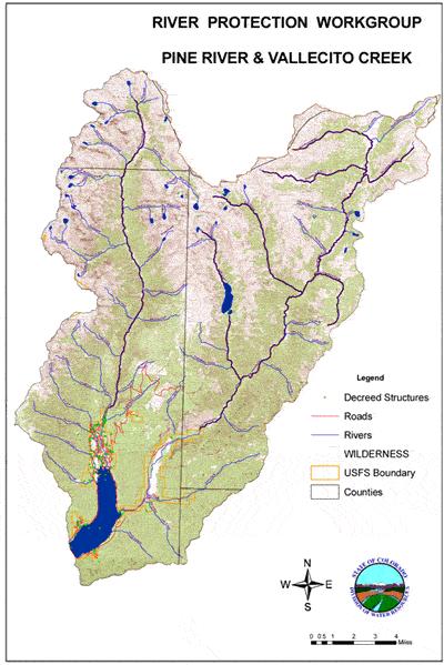
1 River Protection Workgroup Information Sheet Vallecito Creek and Pine River (Version: 7/5/11) This Initial Information Sheet was prepared to inform participants involved in the Vallecito and Pine River Workgroup. This version can be updated and changed as the Workgroup proceeds and as new information is made available or requested. Please refer to the Glossary of Terms and the Glossary of Agencies handouts for clarification on any words used or entities mentioned (documents available at the meetings and on the Web site). Area of Focus: The area of focus includes the watersheds of Vallecito Creek and the Los Pinos River upstream of the USFS boundary with private land. The area drained by Vallecito Creek at the USFS boundary falls mainly in La Plata and San Juan Counties, but also includes portions of Hinsdale County. The area drained by Vallecito Creek includes no private land. The area drained by the Los Pinos River at the USFS boundary falls mainly in Hinsdale County but does include small portions of La Plata and San Juan Counties. This area includes no private land. Please refer to the last page of this document for a map. The San Juan Public Lands Draft Land Use Plan (2007), found Vallecito Creek and the Los Pinos River (and 6 tributaries), upstream of the USFS boundary, to be eligible for Wild and Scenic Rivers ( WSR ) designation. In addition, the Los Pinos and 6 tributaries upstream of the USFS boundary were found to be preliminarily suitable (Draft Land Use Plan 2007). Read on for more information. Values (in alphabetical order): Economic: Livestock grazing; agricultural, domestic and municipal water supplies; outfitting businesses (water-related, dude ranches, hunting, fishing, etc.); and a regional public access and recreation attraction. Fish: Fish species in the Los Pinos River and Vallecito Creek drainages (above the point where the rivers cross the USFS boundary) include but are not limited to Colorado cutthroat trout, rainbow trout, brook trout, brown trout, various subspecies of cutthroat trout, and Emerald lake rainbow trout. Emerald Lake rainbow trout are a rainbow and cutthroat hybrid from late 1880s stocking: a unique strain of fish. The Emerald Lakes were barren of fish until fish were brought up from the Los Pinos River, where there was a hatchery operation, in the late 1880s. Gunnison -1-
2 River rainbow trout were stocked one time in the early 1890s and the result has been a hybridized cutbow : the Emerald Lakes rainbow trout. Yellowstone cutthroat trout were stocked by air one time in 1954 (4000 fingerlings), and genetic tests suggest that that single stocking introduced Yellowstone genetics into the hybridized population. Yellowstone cutthroats are a more lake adapted sub-species of cutthroat trout. The Colorado Division of Wildlife ( CDOW ) applies standard fishing regulations to all waters in the two drainages, except the following: Emerald Lakes (Big and Little): artificial flies and lures only, bag and possession limit and maximum size for trout is two fish, 14 inches long; fishing is prohibited Jan.1 July 15 in the Lake Creek inlet for ½ mile above Big Emerald Lake. Los Pinos River (headwaters to USFS southern Weminuche Wilderness boundary): flies and lures only, 2 fish limit. Vallecito Creek (headwaters to southern boundary of Weminuche Wilderness): flies and lures only, 2 fish limit. All streams located in the Vallecito and Los Pinos drainages within the Weminuche Wilderness capable of supporting trout are wild trout streams (i.e., no stocking occurs). There are no Conservation Populations of Colorado River cutthroat trout in these drainages. A Conservation Population of cutthroat trout is defined as being 90% or more genetically pure. Colorado cutthroat trout have been introduced to the previously barren Sierra Vandera Creek drainage, with success as yet unknown. If successful, it will be a Conservation Population. Most headwater lakes have been stocked by air with CRCT since Because there is little to no reproduction in these cold high elevation lakes, CRCT will eventually be the only fish in the lakes. Flora: The USFS Region 2 Forester identifies a list of Sensitive Species of animals and plants ( for which population viability is a concern, based on significant current or predicted downward trends in populations and/or habitat. See the handout entitled: Checklist of sensitive plant species known to occur, or with potential to occur, in the Vallecito Creek and Los Pinos River drainages above the San Juan National Forest boundary. There are no known occurrences of plant species listed under the federal Endangered Species Act. Geology: The geology of the Area illustrates a broad span of earth s geologic history and contributes to the dramatic scenic values of the two drainages. There are essentially three distinct layers of volcanic activity, each representing large spans of time, overlaying even more ancient sedimentary rocks. Some of the geologic formations include the Pine River Batholith granitic formation, the Rio Grande Pyramid which is part of the Rio Grande Volcanic Flow, and the San Juan Dome. Healthy Natural Landscape: These two watersheds are valuable because they represent a diverse ecosystem that encompasses a diversity of life zones starting with ponderosa pine up to alpine. They are healthy and intact and provide wildlife movement corridors. Due to their overall intactness, as well as the presence of Wilderness within the drainages, they maintain a wild quality. The Weminuche Wilderness is the largest wilderness area in Colorado. The fact that the majority of both of these watersheds falls within designated wilderness is unusual and significant in Colorado. -2-
3 Recreation: The area is part of a highly used regional recreation center in close proximity to Durango and other southwest Colorado communities. It is used for a variety of recreational activities including: Backcountry skiing Backpacking Camping Extreme kayaking Fishing Hiking Horseback riding and horse packing Hunting Mountaineering Rock-climbing Scenery: The area is very beautiful. Terrestrial wildlife: Some of the wildlife species common in the area include: elk, mule deer, big horn sheep, black bear, coyote, bobcat, mountain lion, beaver, and snowshoe hare. Mountain goats and moose also use the area. The USFS identifies a list of Sensitive Species, some of which are known or likely to occur in the area. In addition, the Colorado Division of Wildlife s (CDOW) State Wildlife Action Plan identifies species most in need of pro-active conservation measures. The CDOW Plan identifies a 2-tiered list of Species of Greatest Conservation Need, with Tier I species having the most urgent need. A handout is available that provides more information on USFS, State and Federally listed species with potential to use the Area of Focus. USFS-Identified Outstandingly Remarkable Values or ORVs : As part of its evaluation of rivers for Wild and Scenic River (WSR) eligibility, the USFS analyzes rivers for any river-related values that are unique, rare, or exemplary, and that are significant at a regional or national scale. These features are identified as Outstandingly Remarkable Values. The following box provides a description of the ORVs identified for Vallecito Creek and for the Los Pinos River and 6 tributaries based on the San Juan Public Lands Center s Draft Land Management Plan: Vallecito Creek Scenery The valley provides outstanding views of the stream in the impressive granite canyon, and the views of surrounding mountains. Recreation The creek is popular with extreme kayakers due to its difficulty (Class 5+) and the sheerwalled granite canyon, which provides extremely narrow slots. It is recommended for expert kayakers only. It has crystal-clear water flowing through an incredible gorge with some of the highest-quality drops to be found. It is also nationally significant for whitewater recreation. It s listing on American Whitewater s national river inventory, while not sufficient by itself to be an ORV, supports the above analysis [DLMP Appendix D]. Los Pinos River and 6 Tributaries (Lake Creek, Flint Creek, Sierra Vandera Creek, Snowslide Gulch, Rincon la Osa, Rincon la Vaca) Scenery The Los Pinos River corridor stands out as spectacular and distinctive. The peaks and granite ridge tops are focal points capping the deep canyons delineated by rock outcrops and precipitous vertical walls. Near the Continental Divide the granite landscape gives way to peaks surrounded by open alpine valleys and slopes. The corridor and valley support both coniferous and deciduous forests and shrub lands, giving way to dramatic displays of color in the fall. The upper valley is dotted with numerous lakes and ponds, and the waters running down valley rest in pools between series of cascades and vertical waterfalls [paraphrased from Los Pinos River Wild and Scenic Recommendation]. -3-
4 Land and Water Protections Currently in Place Roadless Area: The majority of the Area of Focus lies within the Weminuche Wilderness. However, about 3100 acres of the Weminuche Adjacent 2006 Inventoried Roadless Area fall within the Area of Focus. The 2001 Roadless Area Conservation Rule (36 CFR 294) prohibits road construction and timber harvest, with limited exceptions, in Inventoried Roadless Areas. The 2001 rule is currently in litigation with different courts issuing conflicting decisions. It seems likely that some version of a roadless rule although it is not clear which one (the Colorado Rule or the Federal Rule) will be in place in the future, restricting road construction and timber-harvest. Wilderness: The majority of the Vallecito Creek watershed (46,400 acres) and the entire Los Pinos River watershed (67,840 acres), where they cross the USFS boundary with private land, fall within the Weminuche Wilderness. Wild and Scenic Suitability: The Wild and Scenic Rivers Act of 1968 directed the US Department of Agriculture and the US Department of Interior to evaluate selected rivers for potential addition to the W&S Rivers System. In 1979, one such suitability study was completed for the Los Pinos River and tributaries, and recommended designation for these segments. The Los Pinos River and 6 tributaries were re-evaluated in 1989, with no changes made. In order to manage this suitable river for its potential inclusion into the National Wild and Scenic River System, the USFS uses existing authorities to protect the Los Pinos River s free-flowing character, water quality, ORVs and recommended classification as Wild. According to the San Juan Public Lands 2007 Draft Environmental Impact Statement (p.3.549): A finding of suitability does not create a water right. A water resource project proposed on a suitable river will be analyzed as to its effect on a river s free-flow, water quality, and outstandingly remarkable values, with adverse effects prevented to the extent of existing agency authorities (such as special-use authority) and subject to valid existing rights. Projects on a suitable river may be subject to more intense analysis and additional mitigation, compared to rivers not eligible or suitable. See page 10 for information on the currently proposed suitability under the San Juan Public Lands 2007 Draft Land Management Plan. USFS management: The entire focus area is managed by the USFS. The box on the next page provides more information: -4-
5 Vallecito Creek (above the USFS boundary) The San Juan Public Lands Center s Draft Land Management Plan allocates the entire watershed to Management Area (MA)1W, Natural Processes Dominate: Designated Wilderness, Wilderness Study Areas and Piedra Area, other than a small area in the southeastern portion of the drainage on the west flank of Middle Mountain. This area falls outside of the Weminche Wilderness Area and the Draft Plan allocates it partly to MA 3 Natural Landscape with Limited Management, (portions of the Weminuche Adjacent Inventoried Roadless Area ), and partly to MA 5 Active Management. The MA 5 portion is mapped as suitable for cattle and sheep grazing, as well as timber harvest and some motorized recreation. Under current management this area outside of the Weminuche Wilderness is all allocated to MA 5 Active Management. Los Pinos River (above the USFS boundary) The San Juan Public Lands Center s Draft Land Management Plan allocates all of the area in the Los Pinos River drainage to Management Area (MA)1W, Natural Processes Dominate: Designated Wilderness, Wilderness Study Areas and Piedra Area. The area would continue to be managed similarly to how it has been in the past if the Draft Plan s recommendations are made final. Overall, the majority of the area would continue to be managed similarly to how it has been in the past if the Draft Plan s recommendations are made final. In-Stream Flows and Minimum Lake Levels: An In-Stream Flow is an in-channel appropriation of non-consumptive water between two specific points and is appropriated by the Colorado Water Conservation Board for the purpose of protecting the natural environment to a reasonable degree. A Minimum Lake Level is a non-consumptive, in-lake use of water made exclusively by the Colorado Water Conservation Board for minimum levels in natural lakes in order to preserve or improve the natural environment to a reasonable degree. Both in-stream flow and natural lake level rights are administered within the State s water right priority system. Vallecito Creek Drainage above USFS boundary In-stream Flows: There are no in-stream flow appropriations within the Vallecito Creek watershed. Minimum Lake Levels: Lake Name Case No. Level (Acre-feet) Appropriation Date Donut Lake W /9/1977 Hazel Lake W /12/1976 Irving Lake W= /12/1976 South Leviathan Lake W /9/
6 Lake Name Case No. Level (Acre-feet) Appropriation Date Lower Leviathan Lake W /9/1977 Lower Sunlight Lake W /12/1976 Mystery Lake W /9/1977 North Leviathan Lake W /9/1977 Sunlight Pothole #1 Lake W /12/1976 Sunlight Pothole #2 Lake W /12/1976 Trinity Lake (aka Upper Storm King) W /9/1977 Upper Sunlight Lake W /12/1976 Vallecito Lake W /12/1976 Los Pinos River Drainage above USFS boundary In-Stream Flows: Stream Name Case No. Amounts (CFS) Appropriation Date Los Pinos River 84CW /13/1984 Minimum Lake Levels: Lake Name Case No. Level (Acre-feet) Appropriation Date Emerald Lake Reservoir W /12/1976 Half Moon Lake W /12/1976 Little Emerald Lake W /12/
7 Lake Name Case No. Level (Acre-feet) Appropriation Date Moon Lake W /12/1976 Annie Lake W /12/1976 Bettie Lake W /12/1976 Big Flint Lake W /12/1976 Divide Lake W /12/1976 Elk Lake W /12/1976 Granite Lake W /12/1976 Little Flint Lake W /12/1976 Rock Lake W /12/1976 Important Water Information Court Actions: USFS Reserved Rights: A case is pending (USFS Reserved Rights Application in Case W B) that involves whether the USFS is entitled to water rights "reserved" as of the date Congress reserved land for the National Forest for fluvial geomorphological (stream-channel maintenance) purposes, and, if so, how much water per stream across USFS land. In short, this case relates to whether or not the USFS holds a Federally Reserved Water Right and, if so, its size. Negotiations to resolve the case have been limited since Municipal and other Consumptive Uses: Vallecito Creek and the Los Pinos River are sources of water for numerous state adjudicated water rights located downstream of the USFS boundary, including but not limited to irrigation, domestic, stock, commercial, fish and municipal water for the communities of Bayfield and Ignacio. Potential for Additional Consumptive Uses: There are no conditional water rights within either the Vallecito Creek or the Los Pinos River above the USFS boundary, therefore there is currently no potential for additional consumptive use within the Area of Focus. A presidential exemption would be needed for development of facilities within the wilderness boundary. -7-
8 Potential Water Diversion and Storage Locations: SWSI sites The State Water Supply Initiative ("SWSI") was a basin-by-basin study conducted by the Colorado Water Conservation Board to examine Colorado's water uses, water-supply needs, and future waterplanning efforts. SWSI focused on using a common technical basis for identifying and quantifying water needs and issues. SWSI catalogued the specific projects, plans, and processes that local water suppliers have identified and are undertaking as components of their own water-supply planning efforts to meet the needs they themselves have identified. In addition, pursuant to House Bill 1117 and the Water for the 21 st Century Act, the Southwest Water Roundtable is evaluating the consumptive and non-consumptive needs in the basin. For more information, go to: (then go to the SWSI I and SWSI II). There are no SWSI identified sites within the Area of Focus. Stream-Flow Data: Several U.S. Geological Survey gauges have been operated in the area. The chart below shows the gauge sites number, name and dates of operation. Gauge Site Number Site Name Dates of Operation LOS PINOS RIVER AT WILDERNESS BNDRY NR BAYFIELD,CO Active LAKE CREEK NEAR BAYFIELD, CO Active LOS PINOS RIVER ABOVE LAKE CREEK NEAR BAYFIELD, CO Active UPPER GRIZZLY INFLOW LOS PINOS R BL SNOSLiDE CAN, NR WEMINUCHE PS, CO PINE R-WEMINUCHE PASS D AT WEMINUCHE PASS, CO VALLECITO CREEK AT CAMPGROUND, LA PLATA, CO VALLECITO CREEK NEAR BAYFIELD, CO. Active VALLECITO CREEK BELOW TAYLOR CREEK NR BAYFIELD, CO Active FIRST CREEK NEAR BAYFIELD, CO Active SECOND CREEK, LA PLATA, CO IRVING CREEK, LA PLATA CO JOHNSON CREEK, LA PLATA, CO ROELL CREEK, LA PLATA, CO UPPER GRIZZLY LAKE SUNLIGHT CREEK, LA PLATA, CO UPPER SUNLIGHT LAKE UPPER SUNLIGHT INFLOW LOWER SUNLIGHT LAKE LOWER SUNLIGHT INFLOW LEVIATHAN CREEK, SAN JUAN, CO ROCK CREEK, SAN JUAN CO NEBO CREEK, VALLECITO CREEK ABOVE NEBO VALLECITO LAKE OUTLET -8-
9 Note: Stream-flow data for each of these gauges is available in a variety of formats on the U.S. Geological Survey Water Data Web site at: Water Rights: The following chart shows water rights. There are no storage water rights within the Area of Focus. The only direct flow water rights are transbasin rights from the Los Pinos River to the Rio Grande River. Please refer to the Glossary of Terms (handed out at the meetings and also on the Web site) to understand these various types of water rights). TRANSBASIN DIRECT FLOW WATER RIGHTS Total # of Rights Total CFS (Cubic feet per second) VALLECITO CREEK (above USFS boundary) Absolute water rights 0 0 Conditional water rights 0 0 LOS PINOS RIVER (above USFS boundary) Absolute water rights 7 58 Conditional water rights 0 0 Water Quality: The Colorado Water Quality Control Commission is the agency responsible for developing specific state water-quality policies to implement the broader policies set forth by the Legislature in the Colorado Water Quality Control Act. The Commission adopts water-quality classifications and standards for surface and ground waters of the state, as well as regulations aimed at achieving compliance with those classifications and standards. There are various categories that apply to measuring water quality. Basic standards are the general water-quality standards that apply to all surface waters of the state. For more detail on water-quality standards, please refer to the handouts at the meeting and/or the State of Colorado s Water Quality Control Division. Above the Weminuche Wilderness boundary, all tributaries of Vallecito Creek and the Los Pinos River are officially designated as Outstanding, as are all streams in Colorado wilderness areas. The hard Precambrian geology of the two watersheds contributes to the generally good water quality. There is one stream within the Vallecito Creek watershed that does have naturally high sulphate levels. There is a USGS national benchmark water quality station at the Vallecito Creek Gage, just inside the wilderness boundary. Between the wilderness boundary and Vallecito Reservoir on both Vallecito Creek and the Los Pinos River, the water quality is classified just as it is above the Wilderness Boundary: Cold Water Fishery 1, Recreation E, Water Supply and Agricultural (See WQTableValue Standards_Vallecito_Pine.pdf and WQStandards_San Juan_Dolores.pdf) Draft Wild and Scenic River (WSR) Information: Both Vallecito Creek and the Los Pinos River above the USFS boundary with private land were found to be eligible for Wild and Scenic Rivers ( WSR ) designation by the United States Forest Service (USFS) in the San Juan Public Lands 2007 Draft Land Management Plan. The Los Pinos River and 6 tributaries were found preliminarily suitable. Stream Vallecito Creek Los Pinos River, above Vallecito Reservoir Eligible Segment USFS boundary with private land USFS boundary with private land Classification Length ORVs Eligible Suitable Wild 16.59mi Recreation and Scenery Yes No Wild 21.89mi Scenery Yes Yes -9-
10 Stream Lake Creek Eligible Segment confluence with Los Pinos River Classification Length ORVs Eligible Suitable Wild 8.05mi Scenery Yes Yes Flint Creek Sierra Vander a Creek Snowsli de Gulch Rincon la Osa Rincon la Vaca confluence with Los Pinos River Wild 7.03mi Scenery Yes Yes Wild 3.67mi Scenery Yes Yes confluence with Los Pinos River Wild 3.51mi Scenery Yes Yes confluence with Los Pinos River Wild 5.69mi Scenery Yes Yes confluence with Los Pinos River Wild 4.33mi Scenery Yes Yes confluence with Los Pinos River Source: San Juan Public Lands Center, 2007 Draft Land Management Plan. Anyone interested in more information can access the actual Wild and Scenic Rivers Act of 1968 and its amendments by going to and look under the Information Tab for WSR Act. This site also offers more user friendly summaries of the Act, under the Publications Tab, in Technical Papers. Note: The website is maintained by the interagency Wild and Scenic Rivers Council. According to the website: The Council consists of representatives of the four wild and scenic rivers administering agencies the Bureau of Land Management, National Park Service, U.S. Fish and Wildlife Service, and U.S. Forest Service. Other federal agencies with river interests have key contacts and participate in discussions affecting their interests. The public has an opportunity to provide input at all Council meetings; their support is crucial to the Council's success. Other Important Information Potential Conflicts: To be discussed thoroughly in the Vallecito and Pine River Workgroup meetings and process. Air Quality: According to the San Juan Public Lands 2007 Draft Land Management Plan, the Weminuche Wilderness Class I Area has been recognized by Congress as being an outstanding special area deserving the highest air-quality protection in the nation. Under the Clean Air Act of 1963, as amended, Federal land managers are responsible for protecting the air quality related values within class I areas. Reasonably Foreseeable Economic Development: Logging There is very little land within the Area of Focus that is available for timber production due to wilderness designation. However, a small portion of the Vallecito Creek drainage above the USFS boundary, on the west flank of Middle Mountain, has been harvested in the past and remains suitable and available for timber production under the San Juan Public Lands Draft Land Management Plan,
11 Oil, Gas, and Mineral development Designated wilderness areas are withdrawn from mineral entry, including oil and gas leasing. There are no privately owned patented mining claims and there are no unpatented mining claims within the Area of Focus. There is no oil and gas potential nor production within the Area of Focus. Private land development There is no private land within the Area of Focus. There is private land with some potential for new development downstream of the points where Vallecito Creek and the Los Pinos River cross the USFS boundary. Commercial outfitting (fishing, hunting, horseback riding, mountaineering, climbing, kayaking etc.) Commercial outfitters require a permit to operate on USFS lands. There are several active permits within the Area of Focus. There is potential for increasing the number of permitted outfitters. Livestock grazing Livestock owners require a permit to graze on public lands. There are active cattle allotments within the lower portion of the two watersheds; all sheep allotments are currently vacant due to proximity to the wild bighorn sheep population. Transportation: Los Pinos Watershed The entire watershed is located within the Weminuche Wilderness, therefore there are no roads. However, there are many trails along the mainstem and tributaries: over 53.8 miles within the river corridors evaluated for Wild and Scenic. Vallecito Creek Watershed The entire watershed is located within the Weminuche Wilderness, therefore there are no roads. However, there are 17.6 miles of trail within the corridor evaluated for Wild and Scenic by the USFS. Weeds: The San Juan National Forest s Invasive Species Action Plan for FY identifies as priorities for treatment the following weed species that are known to occur in the vicinity of the Vallecito Creek and Los Pinos River watersheds: scentless chamomile, dames rocket, yellow toadflax, houndstongue, spotted knapweed, leafy spurge, oxeye daisy, hoary cress, Scotch thistle, musk thistle, bull thistle, Canada thistle. Weed infestations are largely focused along trails and roads. Wildfire: Two recent wildfires - the 2002 Missionary Ridge Fire that burned 70,000 acres around Vallecito Reservoir, and the 2003 Bear Creek Fire that burned 1,500 acres in the upper Vallecito Creek watershed significantly impacted water quality in the drainage in the years immediately following the fires. Map (see next page) For more information, please contact: Bruce Whitehead, Southwestern Water Conservation District at or water@frontier.net Dan Randolph, San Juan Citizens Alliance at x 1 or dan@sanjuancitizens.org Workgroup facilitator, Tami Graham at or tamigraham11@gmail.com Web site:
12 -12-
Piedra River Protection Workgroup Meeting #5 Feb. 21, 2012 Ross Aragon Community Center, Pagosa Springs
 Piedra River Protection Workgroup Meeting #5 Feb. 21, 2012 Ross Aragon Community Center, Pagosa Springs What happened at this meeting? - Identified conservation easements - Discussed In-stream Flows -
April 10, Mark Stiles San Juan Public Lands Center Manager 15 Burnett Court Durango, CO Dear Mark,
 Mark Stiles San Juan Public Lands Center Manager 15 Burnett Court Durango, CO 81301 Dear Mark, We are pleased to offer the following comments on the draft San Juan Public Lands Center management plans
Role of the Protected Area
 Role of the Protected Area Provincial and Regional Context Height of the Rockies and Elk Lakes provincial parks lie in southeastern British Columbia in the Rocky Mountains, about 85 km southwest of Calgary,
MANAGEMENT DIRECTION STATEMENT June, 1999
 Thompson River District MANAGEMENT DIRECTION STATEMENT June, 1999 for Clearwater River Corridor (Addition to Wells Gray Park) Ministry of Environment Lands and Parks BC Parks Division ii Table of Contents
2.0 PARK VISION AND ROLES
 2.0 PARK VISION AND ROLES 2.1 Significance in the Protected Area System Marble Range and Edge Hills provincial parks protect 6.8% of the Pavillion Ranges Ecosection, which is located in the Southern Interior
TAYLOR CANYON RANCH COLORADO - ROUTT COUNTY - STEAMBOAT SPRINGS
 TAYLOR CANYON RANCH COLORADO - ROUTT COUNTY - STEAMBOAT SPRINGS Tucked up against the steep valley shaped by Mt. Pau and rising to the Routt National Forest, Taylor Canyon Ranch is an easily accessible,
Hermosa Area Preservation The Colorado Trail Foundation 4/11/2008
 Hermosa Area Preservation The Colorado Trail Foundation 4/11/2008 Legend d o Tr ail NPA - National Protection Area ra NCA - National Conservation Area o e C Th The Colorado Trail lo FS inventoried Roadless
Wilderness Areas Designated by the White Pine County bill
 Wilderness Areas Designated by the White Pine County bill SEC. 321. SHORT TITLE. This subtitle may be cited as the `Pam White Wilderness Act of 2006'. SEC. 322. FINDINGS. Congress finds that-- The White
Figure 1-Example of terracing from livestock
 To: District Ranger Matt Janowiak April 3, 2016 P.O. Box 439, Bayfield, CO 81122 comments-rocky-mountain-san-juan-columbine@fs.fed.us From: Greg Warren Golden, CO 80401 Please consider the following comments
As outlined in the Tatshenshini-Alsek Park Management Agreement, park management will:
 Management Strategy General Strategy The priority management focus for the park is to ensure that its internationally significant natural, cultural heritage and recreational values are protected and that
Yard Creek Provincial Park. Management Plan
 Yard Creek Provincial Park Management Plan Draft January 2010 Yard Creek Provincial Park Management Plan Approved by: telàlsemkin/siyam/chief Scott Benton Bill Williams Squamish Executive Director ation
Continental Divide National Scenic Trail Legislative History and Planning Guidance
 Continental Divide National Scenic Trail Legislative History and Planning Guidance Legislation, Policy, and Direction Regarding National Scenic Trails The National Trails System Act, P.L. 90-543, was passed
Colorado s Instream Flow Program at 40. ICWP Annual Conference October 16, 2013 Denver, Colorado
 Colorado s Instream Flow Program at 40 ICWP Annual Conference October 16, 2013 Denver, Colorado ISF Program established in 1973 by Senate Bill 97 Recognized the need to correlate the activities of mankind
Outdoor Recreation Opportunities Management
 Outdoor Recreation Opportunities Management Introduction The natural features of Height of the Rockies and Elk Lakes provincial parks provide a wide variety of outdoor recreational activities. However,
Colorado s Instream Flow Program at 40. Celebrating 40 Years of Success and Challenges January 15, 2014 Denver, Colorado
 Colorado s Instream Flow Program at 40 Celebrating 40 Years of Success and Challenges January 15, 2014 Denver, Colorado ISF Program established in 1973 by Senate Bill 97 Recognized the need to correlate
PAUL S PLACE ELK, DEER AND VIEWS FISHTAIL, MONTANA
 McCaslin Land 2010 PAUL S PLACE ELK, DEER AND VIEWS FISHTAIL, MONTANA LOCATION Paul s Place is ideally located in the foothills of the Beartooth Mountains, approximately 5 to 5-1/2 miles west of Fishtail,
3.12 Roadless Areas and Unroaded Areas
 3.12 Roadless Areas and Unroaded Areas Introduction This analysis focuses on the direct and indirect effects of activities proposed in the Como Forest Health project on roadless area values, including
Brinker Creek Ranch. Colorado - Routt County - Yampa
 Located at the base of the Flattops Range in the Steamboat/Vail corridor, Brinker Creek Ranch consists of 1,451 acres ideally suited for high country grazing and native grass hay production. Traditionally
SECTION 3 GENERAL DESCRIPTION OF THE RIVER BASIN
 SECTION 3 GENERAL DESCRIPTION OF THE RIVER BASIN SECTION 3 GENERAL DESCRIPTION OF THE RIVER BASIN River basin description. A general description of the river basin or subbasin, as appropriate, in which
Whitefish Range Partnership Tentatively Approved by WRP 11/18/2013!Rec. Wilderness Page 1
 Whitefish Range Partnership Tentatively Approved by WRP 11/18/2013!Rec. Wilderness Page 1 Recommended Wilderness Background The Whitefish Range has a long management and legislative history associated
Decision Memo Broken Wheel Ranch Equestrian Outfitter Special-Use Permit Proposed Action
 Decision Memo Broken Wheel Ranch Equestrian Outfitter Special-Use Permit USDA Forest Service Mississippi Bluffs Ranger District, Shawnee National Forest Jackson and Union Counties, Illinois Proposed Action
MANAGEMENT DIRECTION STATEMENT June, 1999
 Thompson River District MANAGEMENT DIRECTION STATEMENT June, 1999 for Roche Lake Provincial Park Ministry of Environment Lands and Parks BC Parks Division Table of Contents I. Introduction A. Setting
5.0 OUTDOOR RECREATION OPPORTUNITIES AND MANAGEMENT
 5.0 OUTDOOR RECREATION OPPORTUNITIES AND MANAGEMENT 5.1 Introduction This section describes the range of recreational activities that currently take place in Marble Range and Edge Hills Parks, as well
Piedra River Protection Workgroup Meeting # 15 January 15, 2013 Ross Aragon Community Center, Pagosa Springs, Colo.
 Piedra River Protection Workgroup Meeting # 15 January 15, 2013 Ross Aragon Community Center, Pagosa Springs, Colo. What happened at this meeting? 1. Final river segment analysis completed. 2. Discussion
Sawtooth National Forest Fairfield Ranger District
 United States Department of Agriculture Forest Service Sawtooth National Forest Fairfield Ranger District P.O. Box 189 Fairfield, ID. 83327 208-764-3202 Fax: 208-764-3211 File Code: 1950/7700 Date: December
OPPORTUNITIES FOR WILD & SCENIC RIVER DESIGNATION
 OPPORTUNITIES FOR WILD & SCENIC RIVER DESIGNATION IN SOUTHWEST WASHINGTON S VOLCANO COUNTRY Washington's legendary volcanoes - Mount St. Helens, Mount Rainier and Mount Adams - are the source of wild,
Dan Dallas, Supervisor July 3, 2017 Rio Grande National Forest 1803 W. Highway 160 Monte Vista, CO 81144
 Dan Dallas, Supervisor July 3, 2017 Rio Grande National Forest 1803 W. Highway 160 Monte Vista, CO 81144 Dear Supervisor Dallas: I am writing today on behalf of the Colorado Native Plant Society to express
APPENDIX. Alberta Land Stewardship Act AMENDMENTS TO THE SOUTH SASKATCHEWAN REGIONAL PLAN
 APPENDIX Alberta Land Stewardship Act AMENDMENTS TO THE SOUTH SASKATCHEWAN REGIONAL PLAN 1 All references to Alberta Environment and Sustainable Resource Development, Environment and Sustainable Resource
(Short Listing) DUPUYER ACREAGE, ROCKY MOUNTAN FRONT
 DUPUYER ACREAGE, ROCKY MOUNTAN FRONT") (Short Listing) DUPUYER ACREAGE, ROCKY MOUNTAN FRONT This unique property is located 8½ miles northwest of Dupuyer, Montana and approximately thirty 30 miles northwest of Choteau, Montana. Great Falls
(Short Listing) DUPUYER ACREAGE, ROCKY MOUNTAN FRONT This unique property is located 8½ miles northwest of Dupuyer, Montana and approximately thirty 30 miles northwest of Choteau, Montana. Great Falls
Existing Resource Information
 Botanical and Wildlife Vegetation alliances/wildlife habitats Grasslands annual/perennial Chaparral mixed/montane/chamise-redshank Riparian montane/valley foothill riparian Sierran mixed conifer Montane
Proposed Scotchman Peaks Wilderness Act 2016 (S.3531)
") 1 Proposed Scotchman Peaks Wilderness Act 2016 (S.3531) Frequently Asked Questions PLACE Where is the area that would be designated as Wilderness? The lands outlined in S.3531 lie within Idaho along its
1 Proposed Scotchman Peaks Wilderness Act 2016 (S.3531) Frequently Asked Questions PLACE Where is the area that would be designated as Wilderness? The lands outlined in S.3531 lie within Idaho along its
Washakie Wilderness Ranch
 Washakie Wilderness Ranch Dubois, Wyoming Fly Fishing Hunting Ranching Conservation Washakie Wilderness Ranch Dubois, Wyoming Introduction: A stunning 160-acre parcel located at the base of the Ramshorn
B HALL RANCH FISHTAIL, MONTANA
 Brochure Courtesy of: B HALL RANCH FISHTAIL, MONTANA w w w. m c c a s l i n l a n d. c o m Page 1 LOCATION The Hall Ranch is ideally located in the foothills of the Beartooth Mountains, approximately 5
Evaluation of Outstanding Remarkable Values for Collawash River March 2011
 Evaluation of Outstanding Remarkable Values for Collawash River March 0 Segment From headwaters of East Fork Collawash River to Buckeye Creek Mileage: miles Free flowing: Yes Scenic:, Substantial River
Decision Memo Ice Age Trail Improvement (CRAC 37)
") Decision Memo Ice Age Trail Improvement (CRAC 37) U.S. Forest Service Chequamegon-Nicolet National Forest, Medford-Park Falls Ranger District Taylor County, Wisconsin T32N, R2W, Town of Grover, Section
Decision Memo Ice Age Trail Improvement (CRAC 37) U.S. Forest Service Chequamegon-Nicolet National Forest, Medford-Park Falls Ranger District Taylor County, Wisconsin T32N, R2W, Town of Grover, Section
General Overview: Acreage:
 General Overview: The Beaver Creek Ranch is located on Beaver Creek in Shell Wyoming, at the base of the western slope of the Big Horn Mountains, one of the west s most spectacular back drops. With an
Fossil Creek Wild & Scenic River Comprehensive River Management Plan Forest Service Proposed Action - details March 28, 2011
 Fossil Creek Wild & Scenic River Comprehensive River Management Plan Forest Service Proposed Action - details March 28, 2011 Primary Goals of the Proposed Action 1. Maintain or enhance ORVs primarily by
Final Environmental Impact Statement for the Merced Wild and Scenic River. Comprehensive Management Plan, Yosemite National Park, Madera and Mariposa
 This document is scheduled to be published in the Federal Register on 02/26/2014 and available online at http://federalregister.gov/a/2014-04061, and on FDsys.gov DEPARTMENT OF THE INTERIOR 4312-FF NATIONAL
ANAGEMENT P LAN. February, for Elk Lakes and Height of the Rockies Provincial Parks. Ministry of Environment, Lands and Parks BC Parks Division
 M ANAGEMENT P LAN February, 1999 for Elk Lakes and Height of the Rockies Provincial Parks Ministry of Environment, Lands and Parks BC Parks Division Elk Lakes & Height of the Rockies Provincial Parks M
Special Recreation Management Areas Extensive Recreation Management Areas Public Lands Not Designated as Recreation Management Areas
 From the Proposed RMP: Special Recreation Management Areas SRMAs are an administrative unit where the existing or proposed recreation opportunities and recreation setting characteristics are recognized
Subject to sale, withdrawal, or error.
 The Crawford L Bar Ranch is located approximately 40 air miles west of Albuquerque, New Mexico. This ranch truly epitomizes the description of New Mexico being the Land of Enchantment. The topography and
FINGER-TATUK PROVINCIAL PARK
 FINGER-TATUK PROVINCIAL PARK PURPOSE STATEMENT AND ZONING PLAN March 2003 FINGER-TATUK PROVINCIAL PARK Purpose Statement and Zoning Plan Finger-Tatuk Provincial Park is 17,151 ha in size. It includes the
Map 1.1 Wenatchee Watershed Land Ownership
 Map 1.1 Wenatchee Watershed Land Ownership Map 1.1 Wenatchee Watershed Land Ownership The Wenatchee watershed lies in the heart of Washington state in Chelan County. Just larger than the state of Rhode
112th CONGRESS. 1st Session H. R. 113 IN THE HOUSE OF REPRESENTATIVES
 HR 113 IH 112th CONGRESS 1st Session H. R. 113 To provide for additions to the Cucamonga and Sheep Mountain Wilderness Areas in the Angeles and San Bernardino National Forests and the protection of existing
13.1 REGIONAL TOURISM ISSUES AND SUMMARY OF FINDINGS
 13 REGIONAL TOURISM T he County of Mariposa s recreation needs and facilities fall within two categories: regional tourism and local recreation. This Element focuses on regional tourism issues related
Wilderness Process #NP-1810: Your letter ID is NP September 5, 2018
 Wilderness Process #NP-1810: Your letter ID is NP-1810-2602-96 September 5, 2018 RE: GMUG Wilderness Evaluation Revised Evaluation Criteria and Draft Report Forest Revision Planning Team: The Continental
KANANASKIS COUNTRY PROVINCIAL RECREATION AREAS MANAGEMENT PLAN DRAFT TERMS OF REFERENCE - November 20, 2007
 KANANASKIS COUNTRY PROVINCIAL RECREATION AREAS MANAGEMENT PLAN DRAFT TERMS OF REFERENCE - November 20, 2007 BACKGROUND There are 42 Provincial Recreation Areas (PRAs) within Kananaskis Country located
BIGHORN BACKCOUNTRY ACCESS MANAGEMENT PLAN
 BIGHORN BACKCOUNTRY ACCESS MANAGEMENT PLAN October, 2002 SPECTACULAR BY NATURE BIGHORN BACKCOUNTRY Alberta s Bighorn Backcountry offers spectacular Rocky Mountain scenery and unforgettable recreational
BUCK POINT RANCH. Aspen Associates Realty
 BUCK POINT RANCH Aspen Associates Realty www.aspenassociatesrealty.com 970.544.5800 WELCOME TO Buck Point Ranch is a 960± acre property located in one of the last pristine valleys in close proximity to
Hartsel Springs Ranch 4,637 Acres Park County, Colorado $4,780,000
 Hartsel Springs Ranch 4,637 Acres Park County, Colorado $4,780,000 Presented By: Farm, Ranch & Recreational Real Estate Hartsel Springs Ranch 4,637 Acres Park County, Colorado $4,780,000 Property Description
Fred Antoine Park. Management Plan. Final Public Review Draft
 Fred Antoine Park Management Plan Final Public Review Draft March 2016 Fred Antoine Park Management Plan Approved by: Jeff Leahy Regional Director Thompson Cariboo Region BC Parks Date Brian Bawtinheimer
Frizzell Creek Ranch Summerville, OR $1,400, ± Acres
 Frizzell Creek Ranch Summerville, OR $1,400,000 165± Acres 1 Introduction The Frizzell Creek Ranch is a beautiful 165± acre ranch located in northeast Oregon at the base of the Wallowa Whitman National
Bear Creek Habitat Improvement Project
 06/10/10 Bear Creek Habitat Improvement Project El Paso County, Colorado Pike National Forest and Colorado Springs Utilities Owned Land Report prepared by: Eric Billmeyer Executive Director Rocky Mountain
Clearwater Lake Provincial Park. Draft Management Plan
 Clearwater Lake Provincial Park Draft Management Plan Clearwater Lake Provincial Park Draft Management Plan Table of Contents 1. Introduction... 3 2. Park History... 4 3. Park Attributes... 4 3.1 Location/Access...4
MANAGEMENT DIRECTION STATEMENT
 Skeena District MAAGEMET DIRECTIO STATEMET August 2000 for Driftwood Extension to Babine Mountains Park Ministry of Environment Lands and Parks BC Parks Division This management direction statement was
WORKSHEET 1 Wilderness Qualities or Attributes Evaluating the Effects of Project Activities on Wilderness Attributes
 WORKSHEET 1 Wilderness Qualities or Attributes Evaluating the Effects of Project Activities on Wilderness Attributes Date: 3/7/2017 Roadless Area: Ruby South Description of Project Activity or Impact to
Bridge River Delta Park. Management Plan. Final Public Review Draft
 Bridge River Delta Park Management Plan Final Public Review Draft March 2016 Bridge River Delta Park Management Plan Approved by: Jeff Leahy Regional Director Thompson Cariboo Region BC Parks Date Brian
Wyoming Public Lands Initiative in Carbon County
 Wyoming Public Lands Initiative in Carbon County THE CARBON COUNTY WPLI ADVISORY COMMIT TEE WANTS YOUR INPUT Wilderness Study Area: A special designation that applies to lands managed to protect wilderness
Daisy Dean Trail 628/619 ATV Trail Construction
 Background and Purpose and Need The Daisy Dean ATV Trail Construction Project is located in the Little Belt Mountains, Musselshell Ranger District, Lewis and Clark National Forest approximately 32 miles
RECREATION. Seven issues were identified that pertain to the effects of travel management on outdoor recreation within portions of the project area.
 RECREATION Seven issues were identified that pertain to the effects of travel management on outdoor recreation within portions of the project area. OPPORTUNITIES FOR SOLITUDE / QUIET TRAILS. One attraction
Tahoe National Forest Over-Snow Vehicle Use Designation
 Tahoe National Forest Over-Snow Vehicle Use Designation USDA Forest Service Tahoe National Forest February 20, 2015 Introduction The Forest Service, U.S. Department of Agriculture will prepare an Environmental
Alternative 3 Prohibit Road Construction, Reconstruction, and Timber Harvest Except for Stewardship Purposes B Within Inventoried Roadless Areas
 Roadless Area Conservation FEIS Summary Table S-1. Comparison of Key Characteristics and Effects by Prohibition Alternative. The effects summarized in this table A would occur in inventoried roadless areas
discover Genuine Montana The Last Best Place Great Falls Montana
 discover Genuine Montana The Last Best Place Great Falls Montana the grandest sight I ever beheld... 1805 Meriwether Lewis journal entry Resting on the high plains along Montana s Rocky Mountain Front
Ranch. Creek. Cow. Mountain
 Cow Creek Mountain Ranch Situated along the southwestern hills of the Laramie Mountains and the Medicine Bow-Routt National Forest in northeastern Albany County, Wyoming. 58 E. Benteen Street Buffalo,
White Mountain National Forest Saco Ranger District
 United States Department of Agriculture Forest Service White Mountain National Forest 33 Kancamagus Highway Conway, NH 03818 Comm: (603) 447-5448 TTY: (603) 447-3121 File Code: 1950 Date: February 26,
French Fire Recovery and Restoration Project Wilderness Resource Impact Analysis
 French Fire Recovery and Restoration Project Wilderness Resource Impact Analysis This Wilderness Resource Impact Analysis for the French Recovery and Restoration Project (Project) includes a review of
Connie Rudd Superintendent, Black Canyon of the Gunnison National Park
 National Park Service U.S. Department of the Interior Black Canyon of the Gunnison National Park and Curecanti National Recreation Area Information Brochure #1 Wilderness and Backcountry Management Plan
Creating a User-Driven Long-Distance OHV Trail Through Partnering
 Joseph Raffaele Outdoor Recreation Planner U.S. Bureau of Land Management Yuma, Arizona Creating a User-Driven Long-Distance OHV Trail Through Partnering BLM is a multiple-use land management agency within
S Central Coast Heritage Protection Act APRIL 21, 2016
 STATEMENT OF GLENN CASAMASSA ASSOCIATE DEPUTY CHIEF, NATIONAL FOREST SYSTEM U.S. FOREST SERVICE U.S. DEPARTMENT OF AGRICULTURE BEFORE THE UNITED STATES SENATE COMMITTEE ON ENERGY AND NATURAL RESOURCES
Payette National Forest Duty Station: New Meadows, Idaho Please respond by March 1, 2013
 THE OPPORTUNITY Payette National Forest Duty Station: New Meadows, Idaho Please respond by March 1, 2013 The Payette National Forest is currently seeking a candidate for a permanent full time Range Program
TETON COUNTY WYOMING PUBLIC LANDS INITIATIVE: TURIANO TEAM PROPOSAL
 TETON COUNTY WYOMING PUBLIC LANDS INITIATIVE: TURIANO TEAM PROPOSAL SUMMARY Protect roadless areas on US Forest Service lands in Teton County, Wyoming using a mix of two designations: National Backcountry
NECHAKO CANYON PROTECTED AREA
 NECHAKO CANYON PROTECTED AREA PURPOSE STATEMENT AND ZONING PLAN March 2003 1 Nechako Canyon Protected Area Purpose Statement and Zoning Plan The Nechako Canyon Protected Area (1,246 hectares) is located
MANAGEMENT DIRECTION STATEMENT
 Lower Mainland District MAAGEMET DIRECTIO STATEMET January 2001 for Liumchen Ecological Reserve Ministry of Environment Lands and Parks BC Parks Division Table of Contents Page Introduction... 1 Purpose
Kwadacha Wilderness Provincial Park and Kwadacha Addition (Kwadacha Recreation Area) Purpose Statement and Zoning Plan
 Purpose Statement and Zoning Plan") Kwadacha Wilderness Provincial Park and Kwadacha Addition (Kwadacha Recreation Area) Purpose Statement and Zoning Plan Located in a remote area of the northern interior of BC, this large park straddles
Kwadacha Wilderness Provincial Park and Kwadacha Addition (Kwadacha Recreation Area) Purpose Statement and Zoning Plan Located in a remote area of the northern interior of BC, this large park straddles
SAN MIGUEL CREEK RANCH. q Trinidad, Las Animas County, Colorado q
 SAN MIGUEL CREEK RANCH q Trinidad, Las Animas County, Colorado q 2 s San Miguel Creek Ranch is a scenic well-balanced cattle and trophy hunting ranch that showcases the very best of Southern Colorado.
APPENDIX G. The WAP Conservation Landscape and Focal Areas
 APPENDIX G The WAP Conservation Landscape and Focal Areas Focal areas were identified as discrete landscape units using the natural basin and range geography of the Nevada landscape. These units were prioritized
Ponderosa Pines Ranch
 PONDEROSA PINES RANCH Ponderosa Pines Ranch Shepherd, Montana $3,285,000. Offered Exclusively By: Sonny Todd Real Estate 301 W First, PO Box 788 Big Timber, MT 59011 Office: (406) 932-6668 (406) 932-LAND
DIRECTOR S ORDER #41: Wilderness Preservation and Management
 These are relevant sections about Wilderness Management Plans from National Park Service 2006 Management Policies, Director s Orders #41 and Reference Manual 41. National Park Service U.S. Department of
White Mountain National Forest
 White Mountain National Forest United States Department of Agriculture Forest Service Eastern Region Boles Brook Snowmobile Bridge Decision Memo Boles Brook Snowmobile Bridge Project Town of Woodstock
Marchand Provincial Park. Management Plan
 Marchand Provincial Park Management Plan 2 Marchand Provincial Park Table of Contents 1. Introduction... 3 2. Park History... 3 3. Park Attributes... 4 3.1 Natural... 4 3.2 Recreational... 4 3.3 Additional
DIDYMO SURVEY, LOWER FRYINGPAN RIVER, BASALT, COLORADO 2015
 DIDYMO SURVEY, LOWER FRYINGPAN RIVER, BASALT, COLORADO 2015 Second Annual Report PREPARED FOR: ROARING FORK CONSERVANCY PREPARED BY: COLORADO MOUNTAIN COLLEGE NATURAL RESOURCE MANAGEMENT PROGRAM TIMBERLINE
Mark West Creek Flow Study Report
 Mark West Creek Flow Study Report Biology and Geology of Mark West Creek The headwaters of Mark West Creek are located in the Mayacamas Mountain range, which border Napa and Sonoma County, where it then
BUTCHER CREEK RANCH. Butcher Creek Ranch. Roscoe, Montana. Reduced to $1,650,000.
 BUTCHER CREEK RANCH Butcher Creek Ranch Roscoe, Montana Reduced to $1,650,000. Offered Exclusively By: Sonny Todd Real Estate 301 West First Avenue, PO Box 788 Big Timber, Montana 59011 Office: (406) 932-1031
H. R IN THE HOUSE OF REPRESENTATIVES
 I 113TH CONGRESS 1ST SESSION H. R. 1776 To establish the Clear Creek National Recreation Area in San Benito and Fresno Counties, to designate the Joaquin Rocks Wilderness in such counties, to designate
Williamson Rock/Pacific Crest National Scenic Trail (PCT) Project EIS. Notice of intent to prepare an Environmental Impact Statement.
 Project EIS. Notice of intent to prepare an Environmental Impact Statement.") [3411-15-P] DEPARTMENT OF AGRICULTURE Forest Service Angeles National Forest; Los Angeles County, CA Williamson Rock/Pacific Crest National Scenic Trail (PCT) Project EIS AGENCY: ACTION: Forest Service,
[3411-15-P] DEPARTMENT OF AGRICULTURE Forest Service Angeles National Forest; Los Angeles County, CA Williamson Rock/Pacific Crest National Scenic Trail (PCT) Project EIS AGENCY: ACTION: Forest Service,
Pembina Valley Provincial Park. Draft Management Plan
 Pembina Valley Provincial Park Draft Management Plan 2 Pembina Valley Provincial Park Table of Contents 1. Introduction... 3 2. Park History... 3 3. Park Attributes... 3 3.1 Natural... 3 3.2 Recreational...
2.1 Physical and Biological Description Matabitchuan River Watershed
 2.1 Physical and Biological Description Watershed 2.1.1 Physical Description The system watershed has a total area of about 933 km 2 and is a tributary system to Lake Temiskaming and the Ottawa River Drainage
ANAGEMENT. LAN November, 1996
 M ANAGEMENT P LAN November, 1996 for Paul Lake Provincial Park Ministry of Environment, Lands and Parks BC Parks Department Paul Lake Provincial Park M ANAGEMENT P LAN Prepared by BC Parks Kamloops Area
Description of the Proposed Action for the Big Creek / Yellow Pine Travel Plan (Snow-free Season) and Big Creek Ford Project
 and Big Creek Ford Project") Description of the Proposed Action for the Big Creek / Yellow Pine Travel Plan (Snow-free Season) and Big Creek Ford Project Payette National Forest Krassel Ranger District Valley and Idaho Counties, Idaho
Description of the Proposed Action for the Big Creek / Yellow Pine Travel Plan (Snow-free Season) and Big Creek Ford Project Payette National Forest Krassel Ranger District Valley and Idaho Counties, Idaho
DECISION MEMO. Rawhide Trail #7073 Maintenance and Reconstruction
 Page 1 of 6 Background DECISION MEMO USDA Forest Service Jefferson Ranger District Jefferson County, Montana Rawhide Trail #7073 is located in the Elkhorn Mountain Range approximately 10 miles east of
Ortiz River Ranch Pagosa Springs, Colorado
 Ortiz River Ranch Pagosa Springs, Colorado This ranch provides an exceptional opportunity to own a property with frontage on the San Juan and Navajo Rivers, lush irrigated pastures, and beautiful rolling
White Mountain National Forest Saco Ranger District
 United States Department of Agriculture Forest Service White Mountain National Forest Saco Ranger District 33 Kancamagus Highway Conway, NH 03818 Comm: (603) 447-5448 TTY: (603) 447-3121 File Code: 1950
Lakes Landscape Travel Management
 Decision Notice & Finding of No Significant Impact Lakes Landscape Travel Management USDA Forest Service Columbine Ranger District, San Juan National Forest Archuleta, Hinsdale, and La Plata Counties,
Michipicoten Island Regional Plan
 Michipicoten Island Regional Plan This is one of twenty Regional Plans that support implementation of the Lake Superior Biodiversity Conservation Strategy (Strategy). The Strategy, prepared and overseen
South Colony Basin Recreation Fee Proposal
 South Colony Basin Recreation Fee Proposal Purpose and Need for Collecting Fees in South Colony Basin: Forest Service appropriated funds have not been sufficient to maintain current recreational services
LITTLE LOST MAN CREEK (LLM) (formerly USGS Gaging Station No )
 (formerly USGS Gaging Station No )") LITTLE LOST MAN CREEK (LLM) (formerly USGS Gaging Station No. 11482468) LOCATION: In Redwood National and State Park approximately 0.8 miles upstream from confluence with Prairie Creek and 3.2 miles northeast
LITTLE LOST MAN CREEK (LLM) (formerly USGS Gaging Station No. 11482468) LOCATION: In Redwood National and State Park approximately 0.8 miles upstream from confluence with Prairie Creek and 3.2 miles northeast
CASE NO. 2019CW10 (REF NO. 12CW118).
.") IN THE DISTRICT COURT IN AND FOR WATER DIVISION NO. 4 STATE OF COLORADO TO: ALL PERSONS INTERESTED IN WATER APPLICATIONS IN SAID WATER DIVISION NO. 4 Pursuant to C.R.S. 37-92-302, as amended, you are notified
IN THE DISTRICT COURT IN AND FOR WATER DIVISION NO. 4 STATE OF COLORADO TO: ALL PERSONS INTERESTED IN WATER APPLICATIONS IN SAID WATER DIVISION NO. 4 Pursuant to C.R.S. 37-92-302, as amended, you are notified
Kit Carson-Challenger Ridge Trail Project Annual Performance Report-2014 October 22, 2014
 1 Kit Carson-Challenger Ridge Trail Project Annual Performance Report-2014 October 22, 2014 Willow Lake and Kit Carson Peak 2 SUMMARY The Rocky Mountain Field Institute began Phase 1 of a multi-phase,
DECISION MEMO North Zone (Legacy Trails) Trail Stabilization Project
 Trail Stabilization Project") DECISION MEMO North Zone (Legacy Trails) Trail Stabilization Project USDA FOREST SERVICE Rocky Mountain Region (R2) Shoshone National Forest Wapiti and Greybull Ranger District Park County, Wyoming Background
DECISION MEMO North Zone (Legacy Trails) Trail Stabilization Project USDA FOREST SERVICE Rocky Mountain Region (R2) Shoshone National Forest Wapiti and Greybull Ranger District Park County, Wyoming Background
Adventures in the Rockies. 6 Days
 Adventures in the Rockies 6 Days Adventures in the Rockies On this action-filled adventure, experience two different sides to the Rockies on the western side, discover hidden gems that few visitors get