Wildlife Symposium: U.S. Geological Survey San Diego Reserve Network: Connectivity Planning
|
|
|
- Baldric Fitzgerald
- 5 years ago
- Views:
Transcription


1 Agric ulture Developed Disturbed OpenLand Undisturbed OpenLand Water 1 8 L-1II i L-1C 5 Legend Carlton J. Rochester, Cheryl Brehme, and Robert N. Fisher U. S. eological Survey, San Diego, CA, U.S.A.


2 Outline: Background Connectivity in San Diego Current projects Recommendations


3 Ogden Biological Monitoring Plan for the Multiple Species Conservation Program CBI 23. Review of Regional Habitat Linkage Monitoring Locations SDMMP 211. Connectivity Monitoring Strategic Plan for the San Diego Preserve System.


4 Ogden Biological Monitoring Plan for the Multiple Species Conservation Program CBI 23. Review of Regional Habitat Linkage Monitoring Locations SDMMP 211. Connectivity Monitoring Strategic Plan for the San Diego Preserve System.

")


5 -Linkage between Los Penasquitos Canyon (CA-8) and Black Mountain (CA-1) Length: 17 m -Ogden 1996 & CBI 23 points -Connectivity Monitoring Strategic Plan -Conserved Lands Database -Land use data -Additional evaluation points -High likelihood of connectivity
 - Nonfunctional CA-5 to CA-13: Sycamore Canyon/oodman Ranch to Mt.")
6 CA-1 to CA-2: Otay Mountain/RJER to SDNWR/Crestridge (north of SR-94 at Las Montañas) - Non-functional CA-2 to CA-3: Mcinty Mountain/Crestridge to Harbison Canyon/El Capitan Reservoir (Peutz Valley Road and I-8) - Nonfunctional CA-5 to CA-13: Sycamore Canyon/oodman Ranch to Mt. Woodson (Scripps-Poway Parkway underpass) - Functional but needs improvement CA-8 to CA-1: Los Peñasquitos Canyon to Black Mountain - Functional but needs improvement CA-9 to CA-1: Del Mar Lagoon to Black Mountain - Nonfunctional CA-1 to CA-11: Black Mountain to Lake Hodges/Del Dios - Functional but needs improvement


7 Agric ulture De ve lo p ed Di st u r be d O pe nl a nd Undisturbed OpenLand Water CA-11 to CA-12: Lake Hodges/Del Dios to Ramona rasslands/boden Canyon - Non-functional CA-12 to CA-13: Ramona rasslands/boden Canyon to Mt. Woodson/Blue Sky ER - Functional but need improvement CA-5 to CA-8: Sycamore Canyon/oodan Ranch to Torrey Pines/Del Mar Mesa/Los Peñasquitos Canyon - Nonfunctional L-1II i L-1C Legend 1 8 5
8


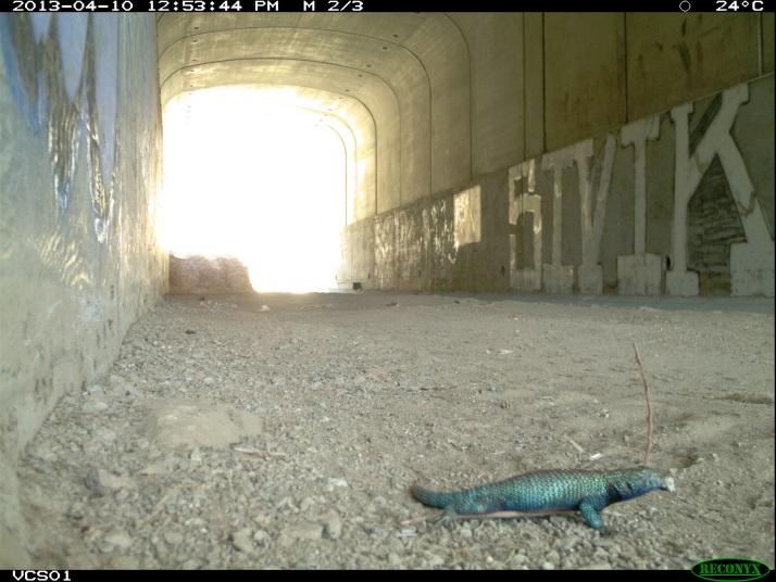
9 Deer mouse round squirrel CA. Kingsnake Long tailed weasel CA. Striped racer Western fence lizard

10 U.C. Davis road kill dataset - SR-94 between Sweetwater River and Otay Lakes Road - Borders both federal and state conserved lands 1 2 Taxa Year Mammam Black tailed jackrabbit 1 California ground squirrel Coyote Deer mouse 2 1 Desert cottontail Desert woodrat 3 opher Long tailed weasel Opossum Raccoon San Diego pocket mouse 1 Spotted skunk 2 Striped skunk Vole 1 1 Reptile Alligator lizard 1 California kingsnake opher snake 1 1 Rosy boa 2 Striped racer 1 2 Western blind snake 1 Western fence lizard 1 1 Western rattlesnake 5 5 2


11 Recommendations: 1. Wildlife structures 2. Land acquisition 3. Data management 4. Data collection


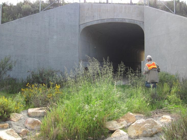
12 SR-94: 1. USFWS National Wildlife Refuge 2. Well documented mortality 3. Wildlife structures 1. Culverts 2. Fencing 3. Cattle gaurds 4. Escape routes

13 SR-94: 1. USFWS National Wildlife Refuge 2. Well documented mortality 3. Wildlife structures 1. Culverts 2. Fencing 3. Cattle gaurds 4. Escape routes

14 Jamul Drive and Mexican Canyon: 1. Wildlife structures 1. Current culvert is undersized, partially filled in, and incised


15 San Pasqual Valley: 1. Data management 1. Properly identify the conserved lands 2. Helps to produce a clearer image of potential connectivity kj i 1112_1 11 L-3.1 i L-3I kj 1112_11 L-3.8 L-7A L _6 1112_9 1112_2 1112_ _ _1 kj 1213_9 1112_4 1112_5 1213_ _3 kj _2 Legend Landuse 1112Linkage Legend OWN_NAME1 Landuse CITY OF SAN DIEO Open Space Park or Preserve Open COUNTY Space OF Park SAN or DIEO Preserve 1213_ _12

16 San Dieguito River Valley: 1. Land acquisition 1. Existing open lands between conservation areas along natural movement routes 2. Not all lands are created equal!


17 San Dieguito River Valley: 1. Land acquisition 1. Existing open lands between conservation areas along natural movement routes 2. Not all lands are created equal! L-4.6 L-4A L L-4.4 L-4.3 L-4.2 L-4.1 kj 1 kj 244!(!( L-4C i 256!(!(!(!(!( 11!(!(!( L-4I Source: Esri, Digitallobe, eoeye, i-cubed, USDA, USS, AEX, etmapping, Aerogrid, IN, IP, swisstopo, and the IS User Community

18 Data collection: 1. Presence data 2. Survey effort 3. Sample method 4. Response to management action 1. Before and after data Road runner
19 Data collection: 1. Presence data 2. Survey effort 3. Sample method 4. Response to management action 1. Before and after data L-4.6 L-4A L L-4.4 L-4.2 L-4.3 L-4.1 kj kj!(!( L-4C i 256!(!(!(!(!( 11!(!(!( L-4I Source: Esri, Digitallobe, eoeye, i-cubed, USDA, USS, AEX, etmapping, Aerogrid, IN, IP, swisstopo, and the IS User Community
20 Data collection: 1. Connectivity Objectives 1. First Priority Large Animal (LA1) 1. MTLN and BDR 2. Second Priority Large Animal (LA2) 1. DEER, BOBC, and RRO 3. First Priority Small Animal (SA1) 1. Lizards, mice, JACK, inverts 4. First Priority Bird (B1) 1. CACW and CAN 5. Second Priority Bird (B2) 1. LBVI and SWFL


21 Data collection: 1. Connectivity Objectives 1. First Priority Large Animal (LA1) 1. MTLN Vickers PS / tracking surveys 2. BDR USS preliminary surveys
22 Data collection: 1. Connectivity Objectives 2. Second Priority Large Animal (LA2) 1. DEER 2. BOBC M. Jennings 3. RRO USS underpass enhancement study
 1. Lizards 2. Mice 3.")
23 Data collection: 1. Connectivity Objectives 3. First Priority Small Animal (SA1) 1. Lizards 2. Mice 3. JACK 4. Inverts
24 Questions:
For Lease RENOVATIONS UNDERWAY CROSTHWAITE CIRCLE, POWAY. Rare opportunity to lease a 192,629 SF industrial/r&d space in Central San Diego
 For Lease 12367 CROSTHWAITE CIRCLE, POWAY RENOVATIONS UNDERWAY Rare opportunity to lease a 192,629 SF industrial/r&d space in Central San Diego Exclusively Listed By KIDDER MATHEWS Mickey Morera Executive
Monterey Coast-Sierra de Salinas Linkage Study. Conducted by The Big Sur Land Trust & Pathways for Wildlife
 Monterey Coast-Sierra de Salinas Linkage Study Conducted by The Big Sur Land Trust & Pathways for Wildlife Objectives & Goals 1) To increase our understanding of wildlife movement throughout the Central
County of Riverside - PSEC Project General Habitat Assessment Appendix A
 County of Riverside - PSEC Project General Habitat Assessment Appendix A Lake Elsinore Lake Elsinore The Lake Elsinore study area is located in the hills directly adjacent to Lake Elsinore, in the City
FAUNAL DATA FROM THE TANQUE VERDE WASH SITE, AZ BB:13:68 (ASM)
") FAUNAL DATA FROM THE TANQUE VERDE WASH SITE, AZ BB:13:68 (ASM) Jennifer A. Waters Cite as: Waters, Jennifer A. 2011 Faunal Data from the Tanque Verde Wash site, AZ BB:13:68 (ASM). .
FAUNAL DATA FROM THE TANQUE VERDE WASH SITE, AZ BB:13:68 (ASM) Jennifer A. Waters Cite as: Waters, Jennifer A. 2011 Faunal Data from the Tanque Verde Wash site, AZ BB:13:68 (ASM). .
County of Riverside - PSEC Project General Habitat Assessment Appendix A
 County of Riverside - PSEC Project General Habitat Assessment Appendix A Paradise Paradise The Paradise study area is located in the mountains within the eastern portion of the City of Norco. Existing
County of Riverside - PSEC Project General Habitat Assessment Appendix A
 County of Riverside - PSEC Project General Habitat Assessment Appendix A Glen Avon Glen Avon The Glen Avon study area is located north of State Route 60 in the Jurupa Mountains, approximately 1 mile south
PUBL DRAFT. MISSION TRAILS REGIONAL PARK 3.7. West Sycamore 3-87
 MISSION TRAILS REGIONAL PARK 3.7. West Sycamore The West Sycamore area is bounded by residential uses on the west, the two-lane Sycamore Canyon Road on the north, Goodan Ranch Sycamore Canyon Preserve
HIGHWAY 17 WILDLIFE and REGIONAL TRAIL CROSSINGS
 HIGHWAY 17 WILDLIFE and REGIONAL TRAIL CROSSINGS Agenda and Meeting Format 7:00-7:15 Welcome 7:15-8:00 Presentation 8:00-8:30 Open House 8:30 Recap 9:00 Conclusion 2 Meeting Goals: Introduce the project
10641 Scripps Summit Court San Diego, CA 92131
 10641 Scripps Summit Court San Diego, CA 92131 EXPERIENCE SUMMIT POINTE Central location with Visibility & access A distinctive opportunity Summit Pointe is a unique tenant focused offi ce renovation in
MEMORANDUM. Honorable Mayor and City Councilmembers William S. Joynes, Sr., City Administrator
 AGENDA ITEM 1A MEMORANDUM DATE: January 17, 2017 TO: FROM: SUBJECT: Honorable Mayor and City Councilmembers William S. Joynes, Sr., City Administrator Sue Polka, Interim Asst. Public Works Director/City
COASTAL CONSERVANCY. Staff Recommendation December 2, 2010 CITY OF SAN DIEGO NCCP PROGRAM VERNAL POOL HABITAT CONSERVATION PLAN
 COASTAL CONSERVANCY Staff Recommendation December 2, 2010 CITY OF SAN DIEGO NCCP PROGRAM VERNAL POOL HABITAT CONSERVATION PLAN Project No. 98-011-02 Project Manager: Mary Small RECOMMENDED ACTION: Authorization
SANDAG s Regional Transportation Plan
 SANDAG s Regional Transportation Plan Oceanside 5 Camp Pendleton Carlsbad P A C C I I F I C C O O C C E E A A N N 472 398 76 Encinitas 399 78 Solana Beach 472 Vista 15 San Marcos 399 399 470 610 Escondido
Our Mission. Discover the many states of California. Chino Hills State Park 1879 Jackson Street Riverside, Ca (951)
") Chino Hills State Park Our Mission The mission of the California Department of Parks and Recreation is to provide for the health, inspiration and education of the people of California by helping to preserve
Chino Hills State Park Our Mission The mission of the California Department of Parks and Recreation is to provide for the health, inspiration and education of the people of California by helping to preserve
The Estelle Mountain (A) study area is located on Bureau of Land Management land, approximately 4 miles south of Lake Mathews.
 study area is located on Bureau of Land Management land, approximately 4 miles south of Lake Mathews.") County of Riverside - PSEC Project General Habitat Assessment Appendix A Estelle Mountain (A) Estelle Mountain A The Estelle Mountain (A) study area is located on Bureau of Land Management land, approximately
County of Riverside - PSEC Project General Habitat Assessment Appendix A Estelle Mountain (A) Estelle Mountain A The Estelle Mountain (A) study area is located on Bureau of Land Management land, approximately
Attachment B: Treatment Area Maps
 Attachment B: Treatment Area Maps BEACH BOAT RENTAL LAUNCH NO.1 LAUNCH NO. 2 LAUNCH NO. 3 LAUNCH NO. 4 CHANNEL BOG Black Moshannon Lake 0 0.125 0.25 0.5 Source: Esri, DigitalGlobe, GeoEye, Earthstar Geographics,
Land Protection Accomplishments
 2017 Land Protection Accomplishments Conserving Open Space and Recreational Access On the Pacific Crest National Scenic Trail View from the Pacific Crest Trail of Donomore Meadows near the California/Oregon
County of Sonoma Agenda Item Summary Report
 Revision No. 20170501-1 of Sonoma Agenda Item Summary Report Agenda Item Number: 37 (This Section for use by Clerk of the Board Only.) Clerk of the Board 575 Administration Drive Santa Rosa, CA 95403 To:
Physical Regions of the U.S.
 Physical Regions of the U.S. Quickly use this map to label the map on your paper Pacific Coast The coast from southern California to Alaska The region of the Pacific Northwest has a long history that was
WIFSS research on E. coli O157:H7 in central coastal California. Rob Atwill, D.V.M., Ph.D. University of California-Davis
 WIFSS research on E. coli O157:H7 in central coastal California Rob Atwill, D.V.M., Ph.D. University of California-Davis To all cooperators: ranchers, growers, regulators, environmentalists, resource managers,
The Lake Mathews study area is located approximately 1.5 miles east of Lake Mathews, and approximately 0.2 mile north of the Colorado River Aqueduct.
 County of Riverside - PSEC Project General Habitat Assessment Appendix A Lake Mathews Lake Mathews The Lake Mathews study area is located approximately 1.5 miles east of Lake Mathews, and approximately
Coast to Crest Trail Corridor Hike
 Coast to Crest Trail Corridor Hike Jim Cunningham, Poway City Council member and Board Chair of the San Dieguito River Park in 2013 has embarked on a project to hike the entire 70-mile San Dieguito River
Hazardous Wildlife Management
 Hazardous Wildlife Management ACI-NA Joint Session Technical & Operations Committee Public Safety & Security Committee Emily Underhill, P.E. Division Director - Development March 16, 2009 Who We Are The
New Class "A" 530,850 SF 2-Building Infill Logistics/ Distribution Development
 14400-14500 KIRKHAM WAY POWAY, CA 92064 New Class "A" 530,850 SF 2-Building Infill Logistics/ Distribution Development DEVELOPMENT OF REPRESENTED BY Mickey Morera 858.369.3030 mmorerea@kiddermathews.com
Coachella Valley Multiple Species Habitat Conservation Plan/ Natural Community Conservation Plan
 Coachella Valley Multiple Species Habitat Plan/ Natural Community Plan 2011 Annual Report For the Period January 1, 2011 to December 31, 2011 Submitted by the Coachella Valley Commission November 2012
II. GENERAL DESCRIPTION OF ENVIRONMENTAL SETTING
 II. GENERAL DESCRIPTION OF ENVIRONMENTAL SETTING A. LOCATION AND BOUNDARIES The proposed Canyon Hills project site is located at 8000 West La Tuna Canyon Road in the City of Los Angeles (the City ). The
Our Summer in Yosemite
 Our Summer in Yosemite Plague Etiologic agent: Yersinia pestis Vector- Fleas Reservoir - Rodents Reservoirs of plague in CA Resistant reservoirs: deer mice, voles, some chipmunks Susceptible/amplifying
DIRECTIONS TO SCHOOLS
 DIRECTIONS TO SCHOOLS BELL JUNIOR HIGH 620 South Briarwood Road San Diego, CA 92139 (619) 479-7111 Take 805 South to Plaza Blvd. exit, stay in the left hand lane. Plaza turns into Paradise Valley Road;
Wolverine-Forest Carnivore Research in the Northern Cascades of Oregon
 Wolverine-Forest Carnivore Research in the Northern Cascades of Oregon Final Progress Report for Field Season 1 (Oct 2012 May 2013) 11 July 2013 Tim L. Hiller 1, Oregon Department of Fish and Wildlife,
REGIONAL WILDLIFE CORRIDOR STUDY. Wind Valley/Dead Mans Flats
 REGIONAL WILDLIFE CORRIDOR STUDY Wind Valley/Dead Mans Flats Part II Wildlife Corridor Delineation Prepared for The Wind Valley Wildlife Corridor Committee that includes: Regulatory Agencies Alberta Sustainable
Santa Rosa Plateau Ecological Reserve
 What s up Third Graders? Yo! So you re coming up to visit the Santa Rosa Plateau Ecological Reserve. That s cool. Maybe you ll see me out on the trail. I m a western fence lizard. Check out my picture.
F RIENDS OF THE SONORAN DESERT Open Space Bond Newsletter
 F RIENDS OF THE SONORAN DESERT Open Space Bond Newsletter Volume 1, Issue 2 Sponsoring Organizations Arizona Open Land Trust Arizona-Sonora Desert Museum Coalition for Sonoran Desert Protection Sonoran
Full County 2013 REPORT
 North San Diego Association of REALTORS $ North San Diego HomeDex TM Full REPORT Statistics HomeDex is an exclusive NSDCAR member benefit PLEASE READ The name HomeDex and its contents are protected under
Buena Vista Ranch 12,075 +/- acres, Terrell County, Texas
 Buena Vista Ranch 12,075 +/- acres, Terrell County, Texas Buena Vista Ranch 12,075 +/- acres Terrell County, Texas James King, Agent Office 432.426.2024 James@KingLandWater.com Location Buena Vista Ranch
Sunrise Ranch 6890 acres, Jeff Davis County, Texas On the Fort Davis Scenic Loop
 Sunrise Ranch 6890 acres, Jeff Davis County, Texas On the Fort Davis Scenic Loop 432-386-2821 Cell 432-426-2024 Office james@kinglandwater.com King Land & Water LLC P.O. Box 109, 600 State Street, Fort
Bat Cave Canyon Ranch 2,920 acres Jeff Davis County, Texas
 Bat Cave Canyon Ranch 2,920 acres Jeff Davis County, Texas James King, Agent Office 432.426.2024 Cell 432.386.2821 James@KingLandWater.com Bat Cave Canyon Ranch 2,920 acres Jeff Davis County, Texas James
 RAMPART BLVD DURANGO DR RAINBOW BLVD NELLIS BLVD DECATUR BLVD DECATUR BLVD MARYLAND PKWY EASTERN AVE PECOS RD PECOS RD LAMB BLVD LAMB BLVD N RANCHO DR S RANCHO DR INDUSTRIAL RD W SAHARA AVE 1 W CHARLESTON
Frazier Canyon Ranch 3,020 Acres Jeff Davis County, Texas
 Frazier Canyon Ranch 3,020 Acres Jeff Davis County, Texas James King, Agent Office 432 426.2024 Cell 432 386.2821 James@KingLandWater.com Frazier Canyon Ranch 3,020 acres Jeff Davis County, Texas James
Hermes Copper Butterfly Translocation, Reintroduction, and Surveys
 Hermes Copper Butterfly Translocation, Reintroduction, and Surveys TASK 1.3: HERMES COPPER TRANSLOCATION 19 August 2018 Prepared for: United States Fish and Wildlife Service Contract: F17AC00963 Contract
2018 Firefighter Boot Drive Locations Thursday, March 1
 2018 Firefighter Boot Drive Locations Thursday, March 1 Alpine Fire Protection District Alpine Boulevard & S. Grade Road Harbison Canyon & Arnold Way Tavern Road & Alpine Boulevard Barona Fire Department
Animals of Mt. Diablo
 Animals of Mt. Diablo This is one suggestion for a one-hour program. Docents are free to present the program in any way they think is effective, especially since you have such a wide variety of animals
Wool Ranch 20 Acres 20 +/- acres Sunol, CA Alameda County
 Wool Ranch 20 Acres 20 +/- acres Sunol, CA Alameda County 707 Merchant Street Suite 100 Vacaville, CA 95688 707-455-4444 Office 707-455-0455 Fax californiaoutdoorproperties.com CalBRE# 01838294 Introduction
South Texas Plains. Texas, Our Texas
 South Texas Plains This is a region characterized by considerable variety. Climatically, the South Texas Plains region is sub-humid to dry. The in the north part of the South Texas, erosion of the Edwards
What is an Marine Protected Area?
 Policies, Issues, and Implications of Marine Protected Areas Kara Anlauf University of Idaho Before the House Subcommittee on Fisheries Conservation, Wildlife and Oceans April 29, 2003 What is an Marine
New Rangers Join Black Mountain Open Space Park
 Canyon News Black Mountain Park Carmel Mountain Preserve Del Mar Mesa Preserve Peňasquitos Canyon Preserve Friends of Los Peñasquitos Canyon Preserve, Inc. New Rangers Join Black Mountain Open Space Park
EAST VALLEY PARKWAY FOR SALE - RESIDENTIAL DEVELOPMENT OPPORTUNITY 3141 E. VALLEY PARKWAY ESCONDIDO, CA ACRE SITE $1,100,000
 3141 E. VALLEY PARKWAY ESCONDIDO, CA 92027-5219 3.31 ACRE SITE $1,100,000 OFFERING HIGHLIGHTS Valley High School Residential Development Opportunity Close to Frances Ryan Park & Multiple Schools Settled
DE LA PLATA OCEANSIDE, CA
 4128 INVESTMENT OR OWNER/USER OPPORTUNITY AT RANCHO DEL ORO TECHNOLOGY PARK AVENIDA DE LA PLATA HENRY ZAHNER 760.889.7943 hzahner@voitco.com Lic. #00887367 RICKY JAMES 951.322.0082 rjames@voitco.com Lic.
AREA OF CRITICAL ENVIRONMENTAL CONCERN RESPONSES TO COMMENTS ATTACHMENT 1. COMMENT LETTER INDEX
 COMMENT LETTER INDEX This appendix provides a list of each entity or individual who provided comments on the Federal Register Notice for the Bureau of Land Management s (BLM s) Areas of Critical Environmental
10926 W OOD SI D E AV E N.
 10926 W OOD SI D E AV E N. SANTEE, CA 92071 F OR SALE OR APPROXIMATELY 91,923 SF STATE OF THE ART INDUSTRIAL / MANUFACTURING BUILDING OWNER USER / INVESTMENT OPPORTUNITY APPROXIMATELY 91,923 SF STATE OF
Potato Chip Grinder. Sheet1
 Potato Chip Grinder MILE DIRECTIONS FOR 0 START: Albertsons 5 Woodland Pkwy San Marcos, CA. (OPEN:00:00 CLOSE:+0:00) Obtain proof of start from local business with time & date stamp. Exit parking lot toward
Death Valley Is a Beautiful but Dangerous Place
 Death Valley Is a Beautiful but Dangerous Place Welcome to This Is America with VOA Learning English. Today we visit one of America s great national parks. It is a place of strange and silent beauty. As
BA Collaborators. Driftless Area Initiative The Prairie Enthusiasts Trout Unlimited TNC TCF Natural Resources Foundation of Wisconsin
 BA Collaborators Driftless Area Initiative The Prairie Enthusiasts Trout Unlimited TNC TCF Natural Resources Foundation of Wisconsin The mission of the of the Blufflands Alliance is to actively conserve
To all our cooperators from across California. be they ranchers, growers, or regulators, activists, resource managers, and the public THANK YOU!
 Managing Rangeland sheds for Agricultural Production, Quality, and Food Safety To all our cooperators from across California be they ranchers, growers, or regulators, activists, resource managers, and
BORREGO EXPLORER PHOTO WORKSHOP 2019 Friday, March 22 nd Sunday, March 24 th. With workshop co-leaders Sandy Zelasko & Barbara Swanson
 BORREGO EXPLORER PHOTO WORKSHOP 2019 Friday, March 22 nd Sunday, March 24 th With workshop co-leaders Sandy Zelasko & Barbara Swanson Workshop Itinerary BORREGO EXPLORER PHOTO WORKSHOP 2019 Friday, March
SEP MAY 2018 ADVENTURE PASSPORT. FREE Family Outdoor Activity
 FREE Family Outdoor Activity SEP. 2017 MAY 2018 ADVENTURE PASSPORT ADVENTURE CURIOSITY EXPLORATION DISCOVERY SHARING LEARNING Otay Valley Regional Park Multi-Jurisdictional Park County of San Diego City
FOR SALE. *Do Not Disturb Tenants El Cajon Blvd San Diego, CA ,061 SF RETAIL INVESTMENT/OWNER-USER OPPORTUNITY $2,000,000 ($492/SF)
") 4427-4433 El Cajon Blvd San Diego, CA 92115 $2,000,000 ($492/SF) 6.% CAP OR VACANT FOR OWNER/USER *Do Not Disturb Tenants KIPP GSTETTENBAUER Senior Vice President RYAN KING Vice President 5.45.3345 kipp@voitco.com
4427-4433 El Cajon Blvd San Diego, CA 92115 $2,000,000 ($492/SF) 6.% CAP OR VACANT FOR OWNER/USER *Do Not Disturb Tenants KIPP GSTETTENBAUER Senior Vice President RYAN KING Vice President 5.45.3345 kipp@voitco.com
APPENDIX G. The WAP Conservation Landscape and Focal Areas
 APPENDIX G The WAP Conservation Landscape and Focal Areas Focal areas were identified as discrete landscape units using the natural basin and range geography of the Nevada landscape. These units were prioritized
1. There are fifty stars on the American flag. 2. The capital city of the USA is New York. 3. The American Declaration of Independence signed in
 Choose the right option. Write true (T) or false (F). 1. There are fifty stars on the American flag. 2. The capital city of the USA is New York. 3. The American Declaration of Independence signed in Philadelphia.
The Sonoran Desert Conservation Plan. Our Land, Our Home, Our Way of Life
 The Sonoran Desert Conservation Plan Our Land, Our Home, Our Way of Life Coalition for Sonoran Desert Protection The Sonoran Desert Conservation Plan The Sonoran Desert Conservation Plan is a comprehensive
HEART MOUNTAIN VERTEBRATE SURVEY 10 August - 13 August 1999
 HEART MOUNTAIN VERTEBRATE SURVEY 10 August - 13 August 1999 Gary P. Beauvais, Heritage Zoologist Wyoming Natural Diversity Database / University of Wyoming 19 August 1999 =====================================================================
Latest developments of ICAO on Wildlife hazard reduction
 University of Nebraska - Lincoln DigitalCommons@University of Nebraska - Lincoln 2011 Bird Strike North America Conference, Niagara Falls Bird Strike Committee Proceedings 9-2011 Latest developments of
The following criteria were used to identify Benchmark Areas:
 7.0 BENCHMARK AREAS The Churn Creek Protected Area offers a significant opportunity to learn more about how grassland ecosystems function. One of the key tools that will be used to monitor larger grassland
SR 934 Project Development And Environment (PD&E) Study
 Study") SR 934 Project Development And Environment (PD&E) Study Project Advisory Group Meeting March 1, 2018 State Road 934/NE/NW 79th Street from west of I-95 (NW 13th CT) to N. Bayshore Drive PD&E STUDY SR 934/NE/NW
SR 934 Project Development And Environment (PD&E) Study Project Advisory Group Meeting March 1, 2018 State Road 934/NE/NW 79th Street from west of I-95 (NW 13th CT) to N. Bayshore Drive PD&E STUDY SR 934/NE/NW
The Chu property is a 6.57 acre parcel located in the Town of Superior on the west side of McCaslin Boulevard. In 2014, the Town of Superior acquired
 1 The Chu property is a 6.57 acre parcel located in the Town of Superior on the west side of McCaslin Boulevard. In 2014, the Town of Superior acquired the Chu property for open space with a contribution
annual report
 The San Dieguito River Valley Conservancy preserves, protects and shares the natural and cultural resources of the San Dieguito River Valley through collaborative efforts to acquire lands, complete trails,
Public Notice. Latitude: N Longitude: W 7.5 Minute Quad: KY-BURLINGTON
 Public Notice US Army Corps of Engineers Louisville District Public Notice No. Open Date: Close Date: 1 Dec 2014 31 Dec 2014 Please address all comments and inquiries to: U.S. Army Corps of Engineers,
CITY OF SUNSET VALLEY WILDLIFE MANAGEMENT PLAN
 1 2 3 CITY OF SUNSET VALLEY WILDLIFE MANAGEMENT PLAN 4 5 6 7 August, 2014 Page 1 of 10 8 9 Table of Contents 10 11 12 13 14 15 16 17 18 19 20 21 22 23 24 25 26 27 28 29 30 31 32 33 34 Executive Summary
The Lower Prut Floodplain Natural Park (Romania)
") The Lower Prut Floodplain Natural Park (Romania) Gabriela Costea Natural Sciences Museum Complex Galati (Romania) & member of the Scientific Council of the Lower Prut Floodplain Natural Park The Prut The
The Lower Prut Floodplain Natural Park (Romania) Gabriela Costea Natural Sciences Museum Complex Galati (Romania) & member of the Scientific Council of the Lower Prut Floodplain Natural Park The Prut The
NOVEMBER San Diego County Summary Statistics
 Copyright 2017 Greater San Diego Association of REALTORS. Data for single-family detached and attached home sales through the Multiple Listing Service of Sandicor, Inc. Neither SDAR nor Sandicor guarantees
FOR SALE Wallner Ranch
 FOR SALE Wallner Ranch 857± Acres Mariposa County, California Exclusively Presented By: Pearson Realty Year round livestock grazing Abundant wildlife Great recreational property CA BRE #00020875 Wallner
Williamson Rock/Pacific Crest National Scenic Trail (PCT) Project EIS. Notice of intent to prepare an Environmental Impact Statement.
 Project EIS. Notice of intent to prepare an Environmental Impact Statement.") [3411-15-P] DEPARTMENT OF AGRICULTURE Forest Service Angeles National Forest; Los Angeles County, CA Williamson Rock/Pacific Crest National Scenic Trail (PCT) Project EIS AGENCY: ACTION: Forest Service,
[3411-15-P] DEPARTMENT OF AGRICULTURE Forest Service Angeles National Forest; Los Angeles County, CA Williamson Rock/Pacific Crest National Scenic Trail (PCT) Project EIS AGENCY: ACTION: Forest Service,
Digital Terrain Analysis of Archer Mountain
 Digital Terrain Analysis of Archer Mountain Identifying a potential new recreational trail Photo: Justin Bush GEOG 593 - Duh Marcus Tobey Justin Bush Project Overview Background Project Area Overview Questions
Planning Wildlife Crossings in Canada's Mountain Parks SESSION: Highway Mitigation: new insights for practitioners
 Planning Wildlife Crossings in Canada's Mountain Parks ID95 SESSION: Highway Mitigation: new insights for practitioners Trevor Kinley, Project Manager Lake Louise Yoho Kootenay Field Unit, Parks Canada
Greening Project Status Report: Grand Canyon National Park
 Greening Project Status Report: Grand Canyon National Park Prepared for the Federal Energy Management Program U.S. Department of Energy February 2001 iii Contents Page 1. Introduction... 1 2. Context of
LOVE FIELD ENVIRONMENTAL ADVISORY COMMITTEE QUARTERLY REPORT
 LOVE FIELD ENVIRONMENTAL ADVISORY COMMITTEE QUARTERLY REPORT October 19, 2017 Dallas Love Field 7555 Lemmon Ave Conference Room 103 AGENDA Introductions Wildlife Hazard Working Group Bachman Lake USTW
Blanco Creek Ranch Acres, Uvalde County, Texas
 Blanco Creek Ranch 1208.30 Acres, Uvalde County, Texas James King, Agent Office 432 426.2024 Cell 432 386.2821 James@KingLandWater.com Blanco Creek Ranch 1208.30 acres Uvalde County, Texas James King,
Daisy Dean Trail 628/619 ATV Trail Construction
 Background and Purpose and Need The Daisy Dean ATV Trail Construction Project is located in the Little Belt Mountains, Musselshell Ranger District, Lewis and Clark National Forest approximately 32 miles
Content. 15 Years of Conservation Initiatives. What is El Carmen? El Carmen in Figures. Awards and Achivements. Collaboration
 Content p 3 What is El Carmen? CEMEX biodiversity conservation legacy. p 13 15 Years of Conservation Initiatives 2016 represents 15 years of continuous conservation. p 4 El Carmen in Figures It is part
LOCATED IN THE PRESTIGIOUS CARLSBAD RESEARCH CENTER
 2258 Rutherford Road Carlsbad, CA LOCATED IN THE PRESTIGIOUS CARLSBAD RESEARCH CENTER HENRY ZAHNER Lic. #00887367 760.889.7943 hzahner@voitco.com RICKY JAMES Lic. #01984985 951.322.0082 rjames@voitco.com
SAN DIEGUITO RIVER VALLEY REGIONAL OPEN SPACE PARK JOINT POWERS AUTHORITY Minutes of April 17, 2009
 SAN DIEGUITO RIVER VALLEY REGIONAL OPEN SPACE PARK JOINT POWERS AUTHORITY MEMBERS PRESENT Pam Slater-Price Chair Betty Rexford Vice-Chair Olga Diaz Richard Earnest Dave Roberts Dianne Jacob Sherri Lightner
Planning and Resource Management for Our Communities and the Environment
 Planning and Resource Management for Our Communities and the Environment 7 June 2002 Scott E. Shewbridge, Ph.D., P.E., G.E. Senior Engineer - Hydroelectric El Dorado Irrigation District 2890 Mosquito Road
A CASE FOR COMPLETING THE JORDAN RIVER PARKWAY: A
 A CASE FOR COMPLETING THE JORDAN RIVER PARKWAY: A safe crossing at 9000 South and 850 West Proposed 9000 South Underpass Parkway Timeline Parkway, Trail, and Tourism Facts Blueprint Jordan River 1971 1973
24-26 March 2014 Cairo, Egypt. Policies & Standards. Session #3 Presentation #2
 24-26 March 2014 Cairo, Egypt Policies & Standards Session #3 Presentation #2 Tackle the Challenges of Wildlife Strikes Adel Ramlawi, P. Eng. Regional Officer, Aerodromes and Ground Aids, ICAO MID Regional
WILLOW CREEK CORPORATE CENTER Willow Creek Road, San Diego, California 92131
 FOR LEASE WILLOW CREEK CORPORATE CENTER 10089 Willow Creek Road, San Diego, California 92131 Willow Creek Corporate Center is located at 10089 Willow Creek Road, in the Scripps Ranch area. The 113,933
McConnell. Spring, summer and fall. George J. Hatfield. State Recreation Areas
 Spring, summer and fall offer fishing, camping, picnicking, river wading, sunbathing, hiking and nature study. Our Mission The mission of the California Department of Parks and Recreation is to provide
FOR SALE SILVER CREEK ESTATES
 FOR SALE SILVER CREEK ESTATES NEC Interstate 80 and Highway 40 Park City Utah Offered at $1,078,000 SILVER CREEK ESTATES Woodside Development 80+ homes Silver Creek Village 1290 single/multi- family homes
The Happenings! September 2017 Volume 35, Issue 9. Sierra Club San Diego Chapter Sierra Social Section. Blue Sky Reserve 7 Lake Poway Loop (M5B)
") The Happenings! September 2017 Volume 35, Issue 9 Sierra Club San Diego Chapter Sierra Social Section Sept 1 Fri 6:30 PM Sierra Talks Sept 9, Sat Dinner And Movie Sept 10, Sun Sept 15, Fri Sept 16, Sat
The Happenings! September 2017 Volume 35, Issue 9 Sierra Club San Diego Chapter Sierra Social Section Sept 1 Fri 6:30 PM Sierra Talks Sept 9, Sat Dinner And Movie Sept 10, Sun Sept 15, Fri Sept 16, Sat
Fully Entitled 50-Acre Corporate Industrial Park. Build-to-Suits For Sale or Lease. 50,000 to 2,000,000 SF
 Fully Entitled 50-Acre Corporate Industrial Park Build-to-Suits For Sale or Lease 50,000 to 2,000,000 SF UP TO 2,000,000 SF BUILD-TO-SUIT DEVELOPMENT FOR SALE OR LEASE 1 2 DEVELOPMENT READY 12 months to
The Redondo Mesa study area is located east of the CNF within hilly terrain 9 miles west of Temecula.
 County of Riverside - PSEC Project General Habitat Assessment Appendix A Redondo Mesa Redondo Mesa The Redondo Mesa study area is located east of the CNF within hilly terrain 9 miles west of Temecula.
PREMIER CARDIFF DEVELOPMENT OPPORTUNITY 17.5 GROSS ACRES
 Views / Ocean Views from Top Portion of Site Zoned RR-2 (21,500 SF Minimum Lot Size) City of Encinitas Jurisdiction One of the Last Premier Undeveloped Large Parcels of Land in San Diego County Submit
9,600 SF Multi-Tenant Retail Center INVESTMENT OPPORTUNITY
 Emerald raldld H Hill Hill Ln Ln Ln Woodside Ave 9,600 SF Multi-Tenant Retail Center INVESTMENT OPPORTUNITY Prospect Ave TABLE OF CONTENTS 04 Executive Summary 04 05 06 08 09 10 11 12 13 14 24 24 24 25
Fire, Brush, and Building Information for Municipalities and Fire Protection Districts in the County of San Diego
 in the Alpine Alpine Fire Protection District 1364 Tavern Road Alpine, CA 91901-2107 (619) 445-2635 http://www.alpinefire.org Bonita / Sunnyside Bonita - Sunnyside Fire Protection District 4900 Bonita
SAN DIEGO, CALIFORNIA
 SAN DIEGO, CALIFORNIA SAN DIEGO HOME OF THE GOOD LIFE San Diego is the eighth largest city in the U.S. and second largest in California. Fashion Valley boasts the city s finest collection of premium retail
Carson City Open Space APNs and , west of Deer Run Road bridge
 32 acres (See separate packet for information on this open space property) OPEN SPACE PROPERTY APNs 008-541-73 and 008-541-92 (north and south sides of the river) Morgan Mill Road River Access Area (parking
FOR SALE. Excellent Owner-User Opportunity El Cajon Blvd San Diego, CA 92115
 FOR SALE Excellent Owner-User Opportunity 6602 El Cajon Blvd San Diego, CA 92115 2aCG 2
628: BELOVEZHSKAYA PUSHCHA STATE NATIONAL PARK (BELARUS)
") WORLD HERITAGE NOMINATION - IUCN SUMMARY 628: BELOVEZHSKAYA PUSHCHA STATE NATIONAL PARK (BELARUS) Summary prepared by WCMC/IUCN (April 1992) based on the original nomination submitted by the Government
WORLD HERITAGE NOMINATION - IUCN SUMMARY 628: BELOVEZHSKAYA PUSHCHA STATE NATIONAL PARK (BELARUS) Summary prepared by WCMC/IUCN (April 1992) based on the original nomination submitted by the Government
Keeping Wilderness Wild: Increasing Effectiveness With Limited Resources
 Keeping Wilderness Wild: Increasing Effectiveness With Limited Resources Linda Merigliano Bryan Smith Abstract Wilderness managers are forced to make increasingly difficult decisions about where to focus
Fully Entitled 50-Acre Corporate Industrial Park. Build-to-Suits For Sale or Lease. 50,000 to 2,000,000 SF
 Fully Entitled 50-Acre Corporate Industrial Park Build-to-Suits For Sale or Lease 50,000 to 2,000,000 SF UP TO 2,000,000 SF BUILD-TO-SUIT DEVELOPMENT FOR SALE OR LEASE 1 2 DEVELOPMENT READY 12 months to
Eagle Pinon Ranch. 2,963 +/- acres, Hudspeth County
 Eagle Pinon Ranch 2,963 +/- acres, Hudspeth County Eagle Piñon Ranch 2963 acres Hudspeth County, Texas Location The Eagles are part of a chain of sky island mountains that stretch from New Mexico through
FOR LEASE Chesapeake Drive. San Diego, CA 92123
 FOR LEASE 9555 Chesapeake Drive San Diego, CA 92123 PROPERTY FEATURES Address 9555 Chesapeake Drive Building Size Building Overview Location Signage 59,175 SF Chesapeake Corporate Center is a two-story
TURN-KEY MEDICAL SUITES AVAILABLE FOR LEASE
 LOS COCHES VILLAGE MEDICAL CENTER 3257 Camino De Los Coches Carlsbad, California 92009 TURN-KEY MEDICAL SUITES AVAILABLE FOR LEASE Property Highlights y TURN-KEY MEDICAL SUITES AVAILABLE FOR LEASE y Located