COASTAL CONSERVANCY. Staff Recommendation December 2, 2010 CITY OF SAN DIEGO NCCP PROGRAM VERNAL POOL HABITAT CONSERVATION PLAN
|
|
|
- Lucy Sharp
- 6 years ago
- Views:
Transcription
1 COASTAL CONSERVANCY Staff Recommendation December 2, 2010 CITY OF SAN DIEGO NCCP PROGRAM VERNAL POOL HABITAT CONSERVATION PLAN Project No Project Manager: Mary Small RECOMMENDED ACTION: Authorization for the City of San Diego to expend up to $56,000 to complete a Vernal Pool Habitat Conservation Plan within the City, including Del Mar, Mira, Kearny, Otay Mesas; Carmel Mountain, Mission Trails Regional Park; Otay Lakes; and Marron Valley, San Diego County. LOCATION: City of San Diego, San Diego County PROGRAM CATEGORY: Resource Enhancement EXHIBITS Exhibit 1: Project Location and Site Map Exhibit 2: Photographs Exhibit 3: June 25, 1998 Staff Recommendation RESOLUTION AND FINDINGS: Staff recommends that the State Coastal Conservancy adopt the following resolution pursuant to Sections and of the Public Resources Code: The State Coastal Conservancy hereby authorizes the City of San Diego to expend up to fiftysix thousand dollars ($56,000) to complete a Vernal Pool Habitat Conservation Plan within the City, more particularly described in the attached Exhibit 1 to the accompanying staff recommendation. Staff further recommends that the Conservancy adopt the following findings: Based on the accompanying staff report and attached exhibits, the State Coastal Conservancy hereby finds that: 1. The proposed project is consistent with the current Project Selection Criteria and Guidelines. 2. The proposed authorization is consistent with the purposes and objectives of Sections and Sections (Chapter 6) of Division 21 of the Public Resources Code, regarding coastal resource enhancement. Page 1 of 6
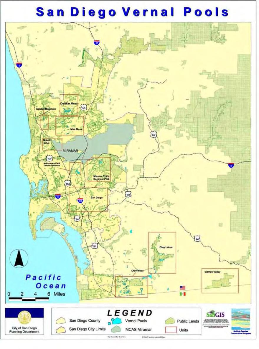
2 CITY OF SAN DIEGO NCCP PROGRAM VERNAL POOL HCP PROJECT SUMMARY: Staff is recommending approval for the City of San Diego to use up to $56,000 of Conservancy funds to develop a Vernal Pool Habitat Conservation Plan (HCP). Conservancy funds may be used to complete the planning, technical studies and environmental review of the HCP. The Vernal Pool HCP will identify strategies and adaptive management techniques to conserve, protect, restore, and enhance natural vernal pool communities. Vernal pool ecosystems are one of the most threatened ecosystems in the San Diego region, with less than 5% of the historic habitat remaining. The Vernal Pool HCP will analyze the remaining habitat, determine the boundaries of preserve areas, include funding mechanisms for long-term maintenance and management and provide the basis for the City to issue incidental take permits. The plan will focus on five threatened or endangered plants, two threatened or endangered animals and one species listed by the California Native Plant Society, including: San Diego and Riverside Fairy Shrimp, San Diego Button Celery, Little Mousetail, Spreading Navarretia, California Orcutt Grass, San Diego Mesa Mint, and Otay Mesa Mint. Federal and state agencies as well as local stakeholders have agreed that the optimal strategy for preservation of vernal pools, and the highly threatened species that depend on them, is through the development of a Vernal Pool HCP. The study area for the HCP focuses on approximately 200,000 acres in the City of San Diego as shown on Exhibit 1. Within the City of San Diego, vernal pools are found in the following areas: Del Mar Mesa, Mira Mesa, Carmel Mountain, Kearny Mesa, Mission Trails Regional Park, Otay Mesa and Otay Lakes, and Marron Valley (Exhibit 1). The HCP and resulting preserve will follow the format of the City of San Diego Multiple Species Conservation Program (MSCP) Subarea Plan. The MSCP is a regional habitat conservation planning program intended to protect endangered and threatened plant and animal species that covers approximately 900 square miles (582,243 acres) in southwestern San Diego County. The MSCP was developed pursuant to the federal and California Endangered Species Acts and the California Natural Community Conservation Planning (NCCP) Act. It was developed through the cooperative effort of participating jurisdictions in partnership with federal and state wildlife agencies, property owners, representatives of the development industry and environmental groups. In 1998, the City of San Diego adopted the MSCP. The MSCP is implemented within the City of San Diego through the City s Subarea Plan and an agreement between the City, the US Fish and Wildlife Service (USFWS) and the California Department of Fish and Game. The City of San Diego and USFWS have entered into an agreement for the planning and preparation of the HCP consistent with the NCCP. The California Department of Fish and Game will be an advisory agency to the HCP process and the project will be done in collaboration with the San Diego Association of Governments (SANDAG).The City will also be responsible for implementing the HCP. The City of San Diego Parks and Recreation Department Open Space Division currently monitors and manages over 20,000 acres of City owned lands as part of the MSCP. The division employs 62 staff to manage and monitor these sites, including rangers, biologists, and planners. Page 2 of 6
3 CITY OF SAN DIEGO NCCP PROGRAM VERNAL POOL HCP Site Description: The study area for the HCP covers 206,124 acres in the southwest portion of San Diego County, on lands owned by or within the jurisdiction of the City of San Diego as shown on Exhibit 1. Within the City of San Diego, vernal pools are found in the following areas: Del Mar Mesa, Mira Mesa, Carmel Mountain, Kearny Mesa, Mission Trails Regional Park, Otay Mesa and nearby Otay Lakes, and Marron Valley. The City of San Diego conducted a detailed Vernal Pool Inventory in , with funding from the USFWS, to document all vernal pools in the City. A total of 2,516 vernal pool basins at 62 sites were mapped during the rainy season. Basins sizes ranged from 2.13 to 68,364 square feet. This inventory will be the foundation of the HCP. In southern California, remnants of historic vernal pool complexes occur on coastal mesas in the counties of Santa Barbara, Los Angeles, Orange and San Diego, as well as inland in the San Diego foothills and Riverside basalt terraces. Vernal pools occur in small depressions underlain by impenetrable clay soils that allow water to accumulate in winter and spring wet seasons. Vernal pool ecosystems are one of the most threatened ecosystems in the San Diego region; it is estimated that 95% of the historic habitat has been lost. Several plants and animals endemic to vernal pools have been listed as federal and/or state endangered species. Vernal pools are significant environmental resources that provide habitat for these rare species. Project History: In June 1998, the Conservancy granted $2,000,000 to the City of San Diego to acquire a specific property to implement the City s NCCP. These funds came from a FY 1998 appropriation from the general fund for implementation of NCCPs. After close of escrow, an audit and survey determined that the City had acquired 6 acres less than had been anticipated at the time of Conservancy approval. As a result, based on the approved appraised value (per acre), the Conservancy s grant agreement was amended to require that the City reduce the Conservancy s contribution to the acquisition by a proportional amount ($46,191), and that those funds be held by the City in an interest bearing account for use on a future project to implement the NCCP, subject to the Conservancy s approval. In May of 2000, the City was informed that $3, in taxes had not been paid at the close of escrow. With Conservancy approval, these back taxes were paid from this account. The balance of that account is currently about $56,000. If approved, this project will use all of the remaining funds. The program began in 1991 under the State's NCCP Act. The NCCP program is managed by the Department of Fish and Game and takes ecosystem approach to planning for the protection and perpetuation of biological diversity. The primary objective of the NCCP program is to conserve natural communities at the ecosystem level while accommodating compatible land use and development. The City of San Diego MSCP Subarea Plan was approved in At the time, some conservationists felt that MSCP did not sufficiently evaluate the impacts to seven vernal pool species and filed a lawsuit in As a result of settlement negotiations, the City of San Diego agreed to develop the HCP to include seven vernal pool species San Diego and Riverside Fairy Shrimp, San Diego Button Celery, Little Mousetail, Spreading Navarretia, California Orcutt Page 3 of 6
4 CITY OF SAN DIEGO NCCP PROGRAM VERNAL POOL HCP Grass, San Diego Mesa Mint, and Otay Mesa Mint as defined and governed by the Endangered Species Act. All development and planning project that potentially affect vernal pools, including public infrastructure projects, are on hold until the HCP is completed or until March 2012, whichever comes first. PROJECT FINANCING Coastal Conservancy 56,000 USFWS Section 6 Grant 500,000 Total Project Costs $556,000 The anticipated source of Conservancy funds is a FY 1998 appropriation from the general fund for NCCP Program. As required by a prior grant agreement, the City has held $46,191 in a segregated, interest bearing account for use on a future project to implement the NCCP, subject to the Conservancy s approval. There is currently about $56,000 in that account. In addition, the City will provide approximately $205,000 of in-kind matching funds. CONSISTENCY WITH CONSERVANCY S ENABLING LEGISLATION: This project is consistent with Section of the Public Resources Code, the Conservancy s enabling legislation, which authorizes the Conservancy to fund plans and feasibility studies and to award grants to public agencies for these purposes. This project also is consistent with Chapter 6 of the Conservancy's enabling legislation, Sections of the Public Resources Code, regarding enhancement of coastal resources. Vernal pools are a rare and valuable coastal resource that was historically found on coastal terraces throughout Southern California. Consistent with Section 31251, the Conservancy may award grants to public agencies to enhance coastal resources that have suffered loss of natural values. Vernal pool ecosystems have suffered significant losses in the San Diego region, less than 5% of the historic habitat remains. Consistent with Section , the Conservancy may award a grant for a project to enhance a coastal resource partly outside the coastal zone at the request of the local public agency with jurisdiction over the project area. The planning area is approximately 200,000 acres, some of which lie outside the coastal zone but all of which benefit the natural or scenic character of coastal resources within the coastal zone. This project area is entirely within the City of San Diego, the local public agency with jurisdiction, and is being undertaken at its request. CONSISTENCY WITH CONSERVANCY S 2007 STRATEGIC PLAN GOAL(S) & OBJECTIVE(S): Consistent with Goal 6, Objective A of the Conservancy s 2007 Strategic Plan, the proposed project would develop a plan to conserve, protect, restore, and enhance coastal watershed resources, specifically vernal pool complexes that occur on coastal mesas. Page 4 of 6
5 CITY OF SAN DIEGO NCCP PROGRAM VERNAL POOL HCP CONSISTENCY WITH CONSERVANCY S PROJECT SELECTION CRITERIA & GUIDELINES: The proposed project is consistent with the Conservancy s Project Selection Criteria and Guidelines, last updated on June 4, 2009, in the following respects: Required Criteria 1. Promotion of the Conservancy s statutory programs and purposes: See the Consistency with Conservancy s Enabling Legislation section above. 2. Consistency with purposes of the funding source: See the Project Financing section above. 3. Support of the public: The HCP process will include agencies, environmental groups, real estate interests, and the academic community. During settlement discussions (see Project History), the stakeholders agreed that the optimal strategy for preservation of vernal pools in the San Diego region would be accomplished through development of a new HCP specific to vernal pool species. Development of the vernal pool HCP has the support of the environmental and developmental communities including the Building Industry Association. 4. Location: The study area for the HCP focuses on approximately 200,000 acres in the City of San Diego as shown on Exhibit 1. The HCP will focus on vernal pools identified in a recent inventory completed by the City. Within the City, vernal pools are found in the following areas: Del Mar Mesa, Mira Mesa, Carmel Mountain, Kearny Mesa, Mission Trails Regional Park, Otay Mesa and nearby Otay Lakes, and Marron Valley. 5. Need: Conservancy funds are needed to fill a non-federal matching requirement for the $500,000 grant from the USFWS. Without the Conservancy funds, the City will not be able to complete this HCP. 6. Greater-than-local interest: Vernal pool ecosystems are one of the most threatened ecosystems in the San Diego region, with less than 5% of the historic habitat remaining. The HCP will help conserve eight very rare species and the habitats they depend upon. 7. Sea level rise vulnerability: In southern California and throughout the City of San Diego, remnant vernal pool complexes occur on coastal mesas, foothills and basalt terraces. These sites are not vulnerable to sea level rise. Additional Criteria 8. Urgency: As discussed above, all development planning, including public infrastructure projects, in the City of San Diego that potentially affect vernal pool habitat are on hold until the HCP in completed. In addition, several of the vernal pool properties are within areas identified and zoned for potential development. Completion of the HCP will facilitate protection of these resources. 10. Leverage: See the Project Financing section above. 11. Conflict resolution: The primary objective of the NCCP program is to conserve natural communities at the ecosystem level while accommodating compatible land use and development. Page 5 of 6
6 CITY OF SAN DIEGO NCCP PROGRAM VERNAL POOL HCP 13. Readiness: The City has received grant funds from the USFWS for this project and is ready to implement it immediately. The City s inventory of vernal pools has been completed and it hopes to complete the HCP by Realization of prior Conservancy goals: See Project History, above. 17. Vulnerability from climate change impacts other than sea level rise: The plan will include scientific forecasts related to climate change and evaluation of how climate change may affect vernal pool resources. The HCP will be done in conjunction with regional efforts including SANDAG s Climate Protection Action Plan. CONSISTENCY WITH LOCAL COASTAL PROGRAM POLICIES: The only vernal pool site in the City s inventory that is within the coastal zone is the Salk Institute site. This site is already preserved. Policies for resource protection from the LCP are included in the management plan for the site. COMPLIANCE WITH CEQA: As a planning activity for possible future actions that have not been approved, adopted, or funded, this project is exempt from California Environmental Quality Act (CEQA) review under 14 California Code of Regulations Section Similarly, the project is exempt from CEQA review under Section 15306, which exempts basic data collection, research, and resource evaluation activities which do not result in a serious or major disturbance to an environmental resource. Upon approval, staff will file a Notice of Exemption for the project. Page 6 of 6

7 Exhibit 1 Project Location Map Project Location
8


9 Exhibit 2: Photographs San Diego vernal pool San Diego button-celery (Eryngium aristulatum var. parishii) San Diego button-celery was listed by the U.S. Fish and Wildlife Service as an endangered species on August 3, 1993, fourteen years after it was listed as endangered by the State of California. It is a CNPS List 1B species. San Diego mesa mint (Pogogyne abramsii) San Diego mesa mint was listed as endangered by the federal government on September 28, 1978, and was listed the following year by the State of California. This plant is a CNPS List 1B species, and is a narrow endemic species under the City of San Diego Land Development Code Biology Guidelines (2001).
10 NCCP PROGRAM IMPLEMENTATION: KONYN PROPERTY ACQUISITION
11 COASTAL CONSERVANCY Project Summary June 25, 1998 NCCP PROGRAM IMPLEMENTATION: KONYN PROPERTY ACQUISITION File No Project Manager: Marc Beyeler RECOMMENDED ACTION: Approval of the San Dieguito River Valley/Multiple Species Conservation Program (MSCP) Enhancement Plan and authorization to disburse funds to the City of San Diego to assist in the acquisition of the Konyn property for habitat protection and open space. LOCATION: San Pasqual Valley, San Dieguito River Valley, San Diego County (Exhibit 1) PROGRAM CATEGORY: Resource Enhancement ESTIMATED COST: City of San Diego (Local Funds) $ 700,000 Coastal Conservancy (NCCP Program) 2,000,000 TOTAL: $2,700,000 PROJECT SUMMARY: Staff recommends that the Conservancy authorize funding for the acquisition of property to assist in the implementation of the Multiple Species Conservation Program (MSCP) of the City of San Diego. This property consists of approximately 338 acres in the San Pasqual Valley within the San Dieguito River Valley. The parcels to be acquired are critical habitat acquisition priorities identified in the MSCP and the San Dieguito River Valley/Multiple Species Conservation Program (MSCP) Enhancement Plan (Exhibit 2). The 11,000-acre San Pasqual Valley, within the much larger coastal San Dieguito River Valley, represents a major open space within the MSCP, linking the coastal portion of the San Dieguito River Valley on the west to the San Dieguito River s source on the 5,700-foot Volcan Mountain to the east. V-1
12 Acquisition of this property will consolidate public ownership of most of the habitat lands in the San Pasqual Valley. The property will be managed by the City of San Diego as part of the San Pasqual properties already held by the City. Staff of the Coastal Conservancy has been working with local public agencies and local citizens to protect and restore the San Dieguito River Valley for the past decade and more. Since earlier this year, Conservancy staff has been working with City of San Diego officials to accomplish the proposed property acquisition. Preservation of the natural features of the coastal draining San Dieguito River Valley through acquisition of sensitive habitat lands contributes to the preservation of the coastal lagoon and wetlands and nearshore water quality through reduced runoff and sedimentation within the river watershed. The San Pasqual Valley contains some of the City of San Diego's most valuable endangered habitats which require protection as part of the City of San Diego s adopted Multiple Species Conservation Program (MSCP). The City of San Diego is taking the lead in a plan to establish a 172,000-acre preserve in southwestern San Diego County. In conjunction with this plan, the City of San Diego has identified the San Pasqual Valley as one of the most critical and largest habitat linkages between the coast and the interior habitat areas within the County. The area contains core populations of sensitive species, including the California gnatcatcher and the coastal cactus wren. The City of San Diego is requesting a $2 million grant to assist in the acquisition of this watershed property in the San Pasqual Valley within the City of San Diego. This timely acquisition grant to the City of San Diego will allow the city to leverage approximately $15 million in habitat acquisitions in the coastal watershed areas of the San Dieguito and Los Penasquitos river valleys. The San Pasqual acquisition is one of the most important acquisitions included in the MSCP. In addition, the other property acquisitions in the coastal portions of both the San Dieguito and Los Penasquitos river valleys which would be leveraged by V-2
13 the San Pasqual Valley acquisition, are also important acquisitions within the MSCP, comprising high quality habitat lands within the Core Biological Resource Areas and Linkages established by the MSCP. The City of San Diego's MSCP program is one of a number of sub-regional plans in San Diego which make up San Diego County s portion of the State of California s Natural Community Conservation Planning (NCCP) program. The NCCP program is intended to protect endangered habitats and species and promote continued regional biodiversity by creating a network of large, interconnected habitat preserves throughout southern California. For FY and again for FY , Conservancy staff submitted budget requests for funds to assist in the acquisition, restoration, and enhancement of sensitive habitat lands in San Diego County consistent with the MSCP. Funds for FY did not survive in the budget approved by the Legislature and signed by the Governor. Funds for FY have been included in the Governor s Budget and have been approved by both houses of the Legislature. Final appropriation of these funds to the Conservancy await approval of the state budget later this year. The City of San Diego has requested action by the Conservancy at this time in order to demonstrate good faith to the private property owner. Disbursement of the funds to the City will be contingent upon the approval of the state budget, including funds specifically targeted for NCCP implementation in San Diego. V-3
14 V-4
15 COASTAL CONSERVANCY Staff Recommendation June 25, 1998 NCCP PROGRAM IMPLEMENTATION: KONYN PROPERTY ACQUISITION File No Project Manager: Marc Beyeler STAFF RECOMMENDATION: Staff recommends that the State Coastal Conservancy adopt the following Resolution pursuant to Sections of the Public Resources Code: "The State Coastal Conservancy hereby approves the San Dieguito River Valley Multiple Species Conservation Program Enhancement Plan, attached to the accompanying staff recommendation as Exhibit 2, and authorizes the disbursement of an amount not to exceed two million dollars ($2,000,000) to the City of San Diego for the costs of acquiring property, located in the San Pasqual Valley within the San Dieguito River Valley, known as the Konyn Property (San Diego County Assessor s Parcel Numbers ; 42 and 43; ; ), subject to the following conditions: 1. No funds shall be disbursed pursuant to this authorization unless and until the Legislature has enacted, and the Governor has signed, a budget for the Fiscal Year that appropriates funds to the Coastal Conservancy for implementation of the NCCP program in San Diego; 2. Prior to the disbursement of any funds, the City shall submit for the review and approval of the Executive Officer of the Conservancy all relevant documents, including the appraisal, agreements of purchase and sale, escrow instructions and documents of title necessary for the acquisition of the property; 3. The property acquired pursuant to this authorization shall be managed and operated in a manner consistent with the purposes of habitat protection and restoration and open space protection, as provided in the San Die- V-5
16 guito River Valley Multiple Species Conservation Program Enhancement Plan, and as the Plan may be amended from time to time; 4. The City shall pay no more than fair market value for the property acquired pursuant to this authorization; and 5. Conservancy funding shall be acknowledged by a sign(s) within the San Pasqual Valley, consistent with a sign plan or equivalent which has been reviewed and approved by the Executive Officer of the Conservancy." Staff further recommends that the Conservancy adopt the following findings: Based on the accompanying staff report and attached exhibits, the State Coastal Conservancy hereby finds that: 1. The proposed project is consistent with the guidelines and criteria set forth in Chapter 6 of the Public Resources Code (Sections ) regarding the enhancement of coastal resources; and 2. The proposed project is consistent with the guidelines and criteria set forth in the Conservancy's Resource Enhancement Program Announcement adopted on March 21, STAFF DISCUSSION: Project Description: The City of San Diego is requesting a grant from the Coastal Conservancy to assist in the acquisition of approximately 338 acres of sensitive habitat lands in the San Pasqual Valley within the San Dieguito River Valley (Exhibit 3). Staff recommends that the Conservancy approve the San Dieguito River Valley/Multiple Species Conservation Program Enhancement Plan and authorize funding to assist in its implementation through the acquisition of parcels located within the San Pasqual Valley. The property to be acquired is designated as a habitat acquisition priority within the San Dieguito River Valley/Multiple Species Conservation Program Enhancement Plan and the MSCP of the City of San Diego. The City of San Diego has requested a two million dollar grant to complete acquisition of V-6
17 critical habitat, riparian, and uplands within the San Pasqual Valley. The San Pasqual Valley represents a major open space within San Diego County, linking the coastal portion of the San Dieguito River Valley to the west with Volcan Mountain to the east. Acquisition of the subject property will consolidate public ownership of most of the valley. The subject property is the highest public acquisition priority in San Pasqual Valley. Preservation of the natural features of the coastal draining San Dieguito River Valley through acquisition of sensitive habitat lands contributes to the preservation of the coastal lagoon and wetlands and nearshore water quality through reduced runoff and sedimentation within the river watershed. Further implementation of the MSCP will achieve local, regional, and statewide goals for natural resource and species protection, as well as open space preservation and the provision of public access opportunities. This grant enables the Coastal Conservancy to utilize the funds for multiple public purposes: habitat protection, open space preservation, and the provision of public access and passive recreation. Project Financing: The City of San Diego is requesting a $2 million grant from the Coastal Conservancy to assist in the acquisition of this watershed property in the San Pasqual Valley within the City of San Diego in order to leverage approximately $15 million in habitat acquisitions in the coastal watershed areas of the San Dieguito and Los Penasquitos River valleys. The City of San Diego will be contributing $700,000 of existing mitigation dollars toward the acquisition of this property. The acquisition of this key parcel utilizing Coastal Conservancy funds would allow the expenditure of limited local dollars to be focused on more costly, but as critical, parcels located further to the west in the coastal zone in the San Dieguito River Valley, Carmel Valley, and Los Penasquitos watershed. The City of San Diego is currently pursuing the approval of a bond issue of approximately $15 million for MSCP short-term acquisition needs. Because the timing of the bond issue will not coincide with the time constraints associated with this opportunity purchase, the provision of funds from the Coastal Conservancy is considered critical. V-7
18 For FY and again for FY , Conservancy staff submitted budget requests for funds to assist in the acquisition, restoration, and enhancement of sensitive habitat lands in San Diego County, as part of the state s NCCP program, consistent with the MSCP. Funds for FY did not survive in the budget approved by the Legislature and signed by the Governor. Funds for FY have been included in the Governor s Budget and have been recommended for approval by the Legislature. Final appropriation of these funds to the Conservancy await approval of the state budget later this year. The City of San Diego has requested action by the Conservancy at this time in order to demonstrate faith to the private property owner. Disbursement of the funds to the City will be contingent upon the approval of the state budget. City of San Diego (Local Funds) $ 700,000 Coastal Conservancy (NCCP Program) 2,000,000 TOTAL: $2,700,000 Site Description: The 338-acre site is located within the City of San Diego s adopted San Pasqual Valley Plan (June 1995) and MSCP Subarea Plan as well as the San Dieguito River Park Concept Plan which proposes to link the coastal portion of the San Dieguito River Valley on the west to Volcan Mountain on the east. Acquisition of this property would not only assist in the implementation of the goals of the City s MSCP and San Pasqual Valley Plan but also the principal objectives of the San Dieguito River Park Joint Powers Authority (JPA). Among the objectives of the JPA in implementing its Concept Plan is the creation of a natural continuous open space from the coast to the crest of Volcan Mountain, which maintains and enhances the San Dieguito River Valley s natural functions including its value as a major coastal watershed and its significant natural habitats. The Konyn property, which contains over 255 acres of sensitive coastal sage scrub habitat and 32 acres of coast live oak woodland habitat, provides a critical link along this corridor from the coast to points further east. In addition, purchase of the property as open space would avoid creating adverse water quality impacts downstream associated with the site s potential devel- V-8
19 opment, thereby improving the water quality in the San Dieguito Lagoon, the river s confluence with the Pacific Ocean. Project History: Staff of the Coastal Conservancy has been working with local public agencies and local citizens to protect and restore the San Dieguito River Valley for the past decade and more. Since earlier this year, Conservancy staff has been working with local officials to accomplish the property acquisition. Staff is recommending that the Conservancy authorize funding to the City of San Diego to assist in the acquisition of the subject property. The property will be managed by the City of San Diego as part of the San Pasqual Valley Management Plan. The management plan is required to be completed with three years of transfer of the property. The plan is expected to focus management on the preservation of existing sensitive resources on the site by directing public access along designated points of interest. San Pasqual Valley contains some of the City of San Diego's most valuable endangered habitats which require protection as part of the City of San Diego s Multiple Species Conservation Program (MSCP). The San Dieguito River Valley also contains significant habitat and species which require protection, restoration and enhancement. The subject property consists of 338-acres and is located within the San Pasqual Valley segment of the San Dieguito River Valley which extends from the coast between Del Mar and Solana Beach to Volcan Mountain north of Julian. Since the late 1950s, the City of San Diego has been the major landowner within the 11,000-acre San Pasqual Valley. The subject property is the largest of only a few remaining private in-holdings within the Valley. Lands acquired thus far by the City have been for the dual purpose of water supply and water quality. The potential exists for the site to be developed with residential uses by the underlying zone, which would have negative effects on the natural functions of the river valley, including loss of natural habitat and degradation of water quality. Preservation of the property s natural habitats would ensure that the natural functions in the immediate area as well as downstream coastal resources would be retained. V-9
20 The City of San Diego is taking the lead in a plan to establish a 172,000-acre preserve in southwestern San Diego County. The City of San Diego's MSCP program is one of a number of subregional plans in San Diego which make up San Diego County s portion of the State of California s Natural Community Conservation Planning (NCCP) program. The NCCP program is intended to protect endangered habitats and species and promote continued regional biodiversity by creating a network of large, interconnected habitat preserves throughout Southern California. PROJECT SUPPORT: The acquisition of additional habitat lands within the San Pascual Valley is supported by federal, state, regional, and local public officials and by local citizens and environmental groups. CONSISTENCY WITH CONSERVANCY'S ENABLING LEGISLATION: This project implements the San Dieguito River Valley/Multiple Species Conservation Program Enhancement Plan consistent with Chapter 6 of the Conservancy's enabling legislation, Sections of the Public Resources Code, regarding enhancement of coastal resources. Consistent with Section 31251, the grant of funds for acquisition of this property will be utilized for the assembly of parcels and the creation of a regional habitat and open space preserve which will enhance the natural and scenic qualities of the San Dieguito River Valley area. Acquisition and enhancement of the San Dieguito River Valley watershed resources will enhance the natural and scenic character of coastal resources, consistent with Section , by retaining natural habitats and linkages for coastal wildlife species. As required under Section , this project is being undertaken at the request of the City of San Diego, which has jurisdiction over the project area. Consistent with 31252, the San Dieguito River Valley is identified as important coastal open space in the City of San Diego s LCP. The City has reviewed the San Dieguito River Valley/Multiple Species Conservation Program Enhancement Plan pursuant to Section 31258(b) and found it to be consistent with the LCP. V-10
21 CONSISTENCY WITH CONSERVANCY'S PROGRAM GUIDELINES: Significance: The San Pasqual Valley property has significant habitat, species, scenic, and open space values and affords opportunities for passive public access. Cooperation: The implementation of the San Dieguito River Valley/Multiple Species Conservation Program Enhancement Plan has the cooperation and support of local residents and government agencies. Scope: Acquisition and enhancement of the San Pasqual Valley property will provide an important link in the coastal greenbelt and habitat preserve for the City of San Diego. CONSISTENCY WITH LOCAL COASTAL PROGRAM POLICIES: The acquisition of the San Dieguito River Valley property is consistent with the City of San Diego's certified Local Coastal Plan and with Coastal Act policies. The City's LCP policies include protecting rare and endangered species and environmentally sensitive habitats, preserving coastal views, and giving priority to preserving coastal open space and developing adequate coastal public access. The San Dieguito River Valley is identified as important coastal open space. The site is identified as a core biological resource area in the adopted MSCP. Preservation of the subject property would further the City s 90 percent conservation goal within its adopted Subarea Plan. The San Diego River Valley/Multiple Species Conservation Program Enhancement Plan, and this recommendation, calls for two implementing actions: acquisition of property for habitat preservation, and preparation of a management plan to preserve the lands so acquired in a natural condition. COMPLIANCE WITH CEQA: Land acquisition for the purpose of preserving the land in its natural condition is categorically exempt from the California Environmental Quality Act, under 14 California Code of Regulations, Section Upon approval, staff will file a Notice of Exemption for this project. V-11
22 V-12
23 EXHIBIT 1 Regional Map V-13
24 V-14
25 EXHIBIT 2 San Dieguito River Valley/Multiple Species Conservation Program Enhancement Plan V-15
26
27 San Dieguito River Valley/Multiple Species Conservation Program Enhancement Plan Preserving San Dieguito River Valley The San Dieguito River Valley lies within the central portion of San Diego County traversing several jurisdictions as it winds from its terminus at the Pacific Ocean, eastward through the San Dieguito Lagoon, then towards its upper reaches in the San Pasqual Valley and further east to the crest of Volcan Mountain. The San Dieguito River Valley has been the center of interest for many in the region who have worked for nearly twenty years to protect and preserve the open space values and rural character of the area. Planning efforts began in the mid-1970 s to preserve and protect the river valley. By the early 1980 s, both the City and County of San Diego had adopted, in concept, plans to establish a regional open space park within the river valley utilizing the natural functions of the river valley as the park s focal point. A Joint Powers Authority (JPA) was formed in 1989 to develop a park plan and in 1994 the San Dieguito River Park Concept Plan was adopted. A focused planning area was identified within which the JPA would direct its efforts to protect the natural resources and visual quality of the river valley, while also providing compatible passive recreational uses. The overall goal statement of the Concept Plan is to: Preserve land within the Focused Planning Area of the San Dieguito River Park as a regional open space greenway and park system that protects the natural waterways and the natural and cultural resources; provide compatible recreational opportunities that do not damage sensitive lands; and provide a continuous and coordinated system of preserved lands with a connecting corridor of walking, equestrian, and bicycle trails encompassing the San Dieguito River Valley from the ocean to the river s source and beyond. Major objectives as summarized in the San Dieguito River Park Planning Framework include: (1) preservation of open space by retaining the valley s natural habitats, protect linkages for wildlife movement and provide compatible areas for recreational uses; and (2) conservation of sensitive resources including the preservation, enhancement, and protection of sensitive coastal wetlands, hillsides, riparian and other freshwater habitat, native vegetation and other historical and cultural resources. Multiple Species Conservation Program (MSCP) Also during the mid-1990 s, the City of San Diego along with the County of San Diego and various other jurisdictions, began the process of developing a habitat conservation plan to address the protection of multiple plant and animal species that were either currently listed as endangered or threatened or were becoming increasingly sensitive due to the rapid rate of development occurring within the region. The Multiple Species Conservation Program (MSCP) focused on conserving vegetation communities and associated species rather than limiting efforts to one species at a time. V-17
28 The primary objectives of the MSCP Plan are to: (1) protect native habitats and species; (2) Accommodate growth and enhance economic development; and (3) Create new federal, state and local partnerships to equitably spread program costs. The central element of the MSCP is to set aside more than one-quarter of a 900 square mile area, approximately 172,000 acres, as a permanent wildlife preserve. The backbone of the preserve is a north-south corridor along the eastern edge of metropolitan San Diego from Escondido to the Mexican border. From this backbone, ribs reach westward to the coast through major river valleys and canyons including the San Dieguito River Valley, Los Penasquitos Canyon, Mission Gorge, Sweetwater River Valley, the Otay River Valley, and the Tijuana River Valley. The preserve will provide protected habitat for 85 species and plants and animals which federal and state wildlife agencies have listed, or might soon list, as endangered or threatened. San Dieguito River Valley/Multiple Species Conservation Program The San Dieguito River Valley/Multiple Species Conservation Program Enhancement Plan would implement the overall goals of the San Dieguito River Park Plan and the City s MSCP Subarea Plan (March 1997) by seeking to preserve and restore lands in the San Dieguito River Valley that have been identified in the MSCP for habitat conservation. Since the River Park JPA was established in 1989, several parcels totaling acres have been acquired by the JPA within the park s focused planning area. Additional lands purchased by or dedicated to the County of San Diego for open space preservation have also been brought into public ownership both to the east and to the west of the San Pasqual Valley. The Conservancy s Enhancement Plan would carry forward these efforts to acquire designated habitat areas, including the Konyn property in the San Pasqual Valley portion of the MSCP and Enhancement Plan areas-one of the largest land acquisitions in the river valley to date. The San Dieguito River Valley is primarily rural in character and is comprised of a large flood plain with a mix of open space, low density residential uses and agricultural parcels. The area supports a variety of habitats including sensitive coastal wetlands in the western reach, riparian forest and wetlands along the entire length of the San Dieguito drainage basin, oak woodland, coastal sage scrub, chaparral, native and non-native grasslands, and Coulter pine forest/mixed conifer forest at the easternmost reach of the focused planning area. The San Dieguito River Valley supports at least 20 sensitive plant species and 55 sensitive animal species. Approximately 10 state and/or federally listed species are known to occur within the focused planning area in which least bell s vireo, California gnatcatcher, coastal cactus wren, southwestern arroyo toad, and golden eagle are found in the San Pasqual Valley; most of which are unique to the coastal ecosystems of southern California. San Pasqual Subarea The San Pasqual Valley lies within the San Dieguito River Valley and includes the tributaries of Santa Maria Creek and Santa Ysabel Creek. The majority of the San Pasqual Valley is owned by the City of San Diego Water Department, which acquired the land for V-18
29 water supply purposes in the late 1950s. Portions of the valley, which include Lake Hodges, comprise one of four City-owned cornerstone lands which were included in the City s MSCP Subarea Plan as they were considered to be essential building blocks for creating a viable habitat preserve. The San Pasqual Valley represents a core biological resource area and is one of the largest continuous blocks of habitat in the MSCP study area that provides a major east-west corridor within the San Dieguito River Valley. The area includes core gnatcatcher and coastal cactus wren populations within the upland habitats, one of the few centers of distribution for Encinitas baccharis, large expanses of grasslands that provide valuable raptor foraging habitat, and critical wetland habitat. The area also includes the San Pasqual Valley Agricultural Preserve which encompasses thousands of acres which have been cultivated since before this century. Enhancement Plan Goals The goals of the San Dieguito River Valley/Multiple Species Conservation Program Enhancement Plan are to preserve and improve natural resources, including coastal resources, protect sensitive habitat for listed species and to provide, where appropriate, and consistent with the San Dieguito River Park Concept Plan and MSCP Subarea Plan, opportunities for public access. To accomplish these goals, the following steps are proposed: 1. Public Acquisition The public acquisition from willing sellers, of lands within the core biological resource areas and associated habitat linkages identified in the MSCP (Appendix 1) should occur where necessary to avoid adverse impacts to the San Dieguito River Valley s water quality and natural habitats. The 338-acre Konyn property is the highest acquisition priority within the San Pasqual segment of the San Dieguito River Valley. Protection of this large block of natural habitat will result in enhancement of natural resources, including importantly significant and sizable coastal resources. Acquisition will provide protection of both plant and animal habitat as well as critical open space and public access opportunities for residents and visitors of San Diego County (Appendicies 1 and 2). The Multi-Habitat Planning Area (MHPA) delineates core biological resource areas and corridors targeted for conservation. The MHPA identifies the watershed management lands around Lake Hodges, including that portion of San Pasqual Valley from Hodges Reservoir east to the area referred to as the narrows, for protection as habitat lands. 2. Management Plan A Management Plan will be prepared by the City of San Diego, in consultation with relevant local, state and federal resource agencies for lands acquired pursuant to this enhancement plan. The Management Plan will be prepared consistent with the adopted resource plans for the area. The Management Plan will be reviewed and approved by the Executive Officer of the Coastal Conservancy. V-19
30 The Management Plan shall provide area specific management directives, consistent with the City s MSCP Subarea Plan, to address the various habitat and species requirements of the land acquired. The plan will include special conditions as may be required by the City s MSCP Subarea Plan. The Management Plan shall address, in detail, public access and recreational needs, as appropriate, and shall identify the public access improvements that can be made consistent with the protection of sensitive resources. The Management Plan shall also include recommendations for restoration of limited disturbed areas on the site that could increase the area of nesting habitat thereby potentially increasing the number of California gnatcatcher pairs using the site. The Management Plan shall be developed within three years of the transfer of the property. Attachments Appendix 1. Core Biological and Linkage Areas Appendix 2. Multi-Habitat Planning Area References City of San Diego, Multiple Species Conservation Program Subarea Plan. City of San Diego, Multiple Species Conservation Program Plan. San Dieguito River Park Joint Powers Authority, San Dieguito River Park Planning Framework. San Dieguito River Park Joint Powers Authority, San Dieguito River Park Concept Plan. Sweetwater Environmental Biologists, Constraints for Konyn Property, San Diego, California. V-20
31 EXHIBIT 3 Konyn Property
COASTAL CONSERVANCY. Staff Recommendation December 2, 2004 COYOTE HELLYER COUNTY PARK BAY AREA RIDGE TRAIL
 COASTAL CONSERVANCY Staff Recommendation December 2, 2004 COYOTE HELLYER COUNTY PARK BAY AREA RIDGE TRAIL File No. 04-057 Project Manager: Amy Hutzel RECOMMENDED ACTION: Authorization to disburse up to
DATE: January 19, WCA Governing Board. Johnathan Perisho, Project Manager. Mark Stanley, Executive Officer
 Item 14 DATE: January 19, 2017 TO: FROM: THROUGH: SUBJECT: WCA Governing Board Johnathan Perisho, Project Manager Mark Stanley, Executive Officer Item 14: Consideration of a resolution to accept an acquisition
COASTAL CONSERVANCY. Staff Recommendation June 5, 2008 GUALALA BLUFF TRAIL OPERATIONS AND MAINTENANCE
 COASTAL CONSERVANCY Staff Recommendation June 5, 2008 GUALALA BLUFF TRAIL OPERATIONS AND MAINTENANCE File No. 08-047-01 Project Manager: Deborah Hirst RECOMMENDED ACTION: Consideration and possible Conservancy
COASTAL CONSERVANCY. Staff Recommendation September 22, 2011 BAY AREA RIDGE TRAIL: HOOD MOUNTAIN TO HIGHWAY 12
 COASTAL CONSERVANCY Staff Recommendation September 22, 2011 BAY AREA RIDGE TRAIL: HOOD MOUNTAIN TO HIGHWAY 12 File No. 11-039-001 Project Manager: Betsy Wilson RECOMMENDED ACTION: Authorization to disburse
COASTAL CONSERVANCY. Staff Recommendation May 27, 2010 SAN DIEGUITO RIVER PARK TRAILS PHASE II TRAIL DESIGN AND CONSTRUCTION
 COASTAL CONSERVANCY Staff Recommendation May 27, 2010 SAN DIEGUITO RIVER PARK TRAILS PHASE II TRAIL DESIGN AND CONSTRUCTION File No. 05-031-02 Project Manager: Christopher Kroll RECOMMENDED ACTION: Authorization
White Mountain National Forest Saco Ranger District
 United States Department of Agriculture Forest Service White Mountain National Forest Saco Ranger District 33 Kancamagus Highway Conway, NH 03818 Comm: (603) 447-5448 TTY: (603) 447-3121 File Code: 1950
ROAD AND TRAIL PROJECT APPROVAL
 ROAD AND TRAIL PROJECT APPROVAL www.marincountyparks.org Marin County Parks, 3501 Civic Center Dr, Suite 260, San Rafael, CA 94903 DATE: July 12, 2017 PRESERVE: Gary Giacomini Open Space Preserve PROJECT:
COASTAL CONSERVANCY. Staff Recommendation March 25, 2004 SONOMA COUNTY COASTAL TRAIL, PHASE I. File No Project Manager: Richard Retecki
 COASTAL CONSERVANCY Staff Recommendation March 25, 2004 SONOMA COUNTY COASTAL TRAIL, PHASE I File No. 03-142 Project Manager: Richard Retecki RECOMMENDED ACTION: Authorization to disburse up to $455,000
Rule Governing the Designation and Establishment of All-Terrain Vehicle Use Trails on State Land
 Rule Governing the Designation and Establishment of All-Terrain Vehicle Use Trails on State Land 1.0 Authority 1.1 This rule is promulgated pursuant to 23 V.S.A. 3506. Section 3506 (b)(4) states that an
2.0 Physical Characteristics
 _ 2.0 Physical Characteristics 2.1 Existing Land Use for the Project The site is comprised of approximately 114 acres bounded by Highway 101 to the north, the existing town of Los Alamos to the east, State
COASTAL CONSERVANCY. Staff Recommendation March 17, 2011 EAST-SLOPE SONOMA MOUNTAIN RIDGE TRAIL PLANNING
 COASTAL CONSERVANCY Staff Recommendation March 17, 2011 EAST-SLOPE SONOMA MOUNTAIN RIDGE TRAIL PLANNING File No. 11-008-01 Project Manager: Sam Jenniches RECOMMENDED ACTION: Authorization to disburse up
Pinellas County Environmental Lands
 Pinellas County Environmental Lands In addition to traditional parks and recreation facilities, Pinellas County owns and manages a system of environmental lands that provides specialized resource-based
Decision Memo Broken Wheel Ranch Equestrian Outfitter Special-Use Permit Proposed Action
 Decision Memo Broken Wheel Ranch Equestrian Outfitter Special-Use Permit USDA Forest Service Mississippi Bluffs Ranger District, Shawnee National Forest Jackson and Union Counties, Illinois Proposed Action
David Magney Environmental Consulting
 David Magney Environmental Consulting DELINEATION OF JURISDICTIONAL WATERS AND RIPARIAN HABITATS FOR LYONS CANYON RANCH, NEWHALL, CALIFORNIA Prepared for: UNITED STATES ARMY CORPS OF ENGINEERS and CALIFORNIA
OPEN SPACE. The Open Space Element describes the County s goals and policies with respect to open space areas and addresses the following topics:
 PURPOSE This element addresses open spaces for: the managed production of resources, outdoor recreation, public health and safety, and the preservation of natural resources. Amador County s open space
Continental Divide National Scenic Trail Legislative History and Planning Guidance
 Continental Divide National Scenic Trail Legislative History and Planning Guidance Legislation, Policy, and Direction Regarding National Scenic Trails The National Trails System Act, P.L. 90-543, was passed
Integrating Transportation and Resource Conservation Planning Conservation Banking
 Chapter Integrating Transportation and Resource Conservation Planning Conservation Banking Introduction INTEGRATING TRANSPORTATION CONSERVATION WITH REGIONAL CONSERVATION PLANNING John DiGregoria (Phone:
Decision Memo for Desolation Trail: Mill D to Desolation Lake Trail Relocation
 for Salt Lake County, Utah Uinta-Wasatch-Cache National Forest Salt Lake Ranger District 1. Background The present location of the Desolation Trail (#1159) between Mill D and Desolation Lake follows old
Daisy Dean Trail 628/619 ATV Trail Construction
 Background and Purpose and Need The Daisy Dean ATV Trail Construction Project is located in the Little Belt Mountains, Musselshell Ranger District, Lewis and Clark National Forest approximately 32 miles
METROPOLITAN COUNCIL 390 North Robert Street, St. Paul, MN Phone (651) TDD (651)
 TDD (651)") DATE: March 27, 2012 METROPOLITAN COUNCIL 390 North Robert Street, St. Paul, MN 55101 Phone (651) 602-1000 TDD (651) 291-0904 TO: Metropolitan Parks and Open Space Commission FROM: Arne Stefferud, Planning
DATE: March 27, 2012 METROPOLITAN COUNCIL 390 North Robert Street, St. Paul, MN 55101 Phone (651) 602-1000 TDD (651) 291-0904 TO: Metropolitan Parks and Open Space Commission FROM: Arne Stefferud, Planning
Michipicoten Island Regional Plan
 Michipicoten Island Regional Plan This is one of twenty Regional Plans that support implementation of the Lake Superior Biodiversity Conservation Strategy (Strategy). The Strategy, prepared and overseen
MONTEREY REGIONAL AIRPORT MASTER PLAN TOPICAL QUESTIONS FROM THE PLANNING ADVISORY COMMITTEE AND TOPICAL RESPONSES
 MONTEREY REGIONAL AIRPORT MASTER PLAN TOPICAL QUESTIONS FROM THE PLANNING ADVISORY COMMITTEE AND TOPICAL RESPONSES Recurring topics emerged in some of the comments and questions raised by members of the
White Mountain National Forest Saco Ranger District
 United States Department of Agriculture Forest Service White Mountain National Forest 33 Kancamagus Highway Conway, NH 03818 Comm: (603) 447-5448 TTY: (603) 447-3121 File Code: 1950 Date: February 26,
National Forests and Grasslands in Texas
 United States Department of Agriculture Forest Service National Forests and Grasslands in Texas Sam Houston NF 394 FM 1375 West New Waverly, Texas 77358 Phone 936-344-6205 Dear Friends, File Code: 1950
Submission to NSW Koala Strategy Consultation Process. March 2017
 Submission to NSW Koala Strategy Consultation Process March 2017 Table of contents Opening 3 Response 3 Whole-of-government NSW koala strategy 3 State Environment Planning Policy (SEPP) 44 3 The draft
Our Mission. Discover the many states of California. Chino Hills State Park 1879 Jackson Street Riverside, Ca (951)
") Chino Hills State Park Our Mission The mission of the California Department of Parks and Recreation is to provide for the health, inspiration and education of the people of California by helping to preserve
Chino Hills State Park Our Mission The mission of the California Department of Parks and Recreation is to provide for the health, inspiration and education of the people of California by helping to preserve
COASTAL CONSERVANCY. Staff Recommendation November 6, 2008 SAN FRANCISCO BAY TRAIL: CANAL BOULEVARD CONSTRUCTION
 COASTAL CONSERVANCY Staff Recommendation November 6, 2008 SAN FRANCISCO BAY TRAIL: CANAL BOULEVARD CONSTRUCTION File No. 07-037-02 Project Manager: Michelle Jesperson RECOMMENDED ACTION: Authorization
Parkland County Municipal Development Plan Amendment Acheson Industrial Area Structure Plan
 Parkland County Municipal Development Plan Amendment Acheson Industrial Area Structure Plan New Plan Acheson Industrial Area Structure Plan Amendment Parkland County Municipal Development Plan Board Reference
Draft LAW. ON SOME AMENDAMENTS IN THE LAW No.9587, DATED ON THE PROTECTION OF BIODIVERSITY AS AMENDED. Draft 2. Version 1.
 Technical Assistance for Strengthening the Capacity of the Ministry of Environment, Forests and Water Administration in Albania for Law Drafting and Enforcement of National Environmental Legislation A
Galveston Bay Estuary Program. Carla G. Guthrie, Ph.D. Galveston Bay Council Member Texas Water Development Board
 Galveston Bay Estuary Program Carla G. Guthrie, Ph.D. Galveston Bay Council Member Texas Water Development Board The statements contained in this presentation are my current views and opinions and are
The Redondo Mesa study area is located east of the CNF within hilly terrain 9 miles west of Temecula.
 County of Riverside - PSEC Project General Habitat Assessment Appendix A Redondo Mesa Redondo Mesa The Redondo Mesa study area is located east of the CNF within hilly terrain 9 miles west of Temecula.
County of Riverside - PSEC Project General Habitat Assessment Appendix A
 County of Riverside - PSEC Project General Habitat Assessment Appendix A Lake Elsinore Lake Elsinore The Lake Elsinore study area is located in the hills directly adjacent to Lake Elsinore, in the City
Map 1.1 Wenatchee Watershed Land Ownership
 Map 1.1 Wenatchee Watershed Land Ownership Map 1.1 Wenatchee Watershed Land Ownership The Wenatchee watershed lies in the heart of Washington state in Chelan County. Just larger than the state of Rhode
Decision Memo Ice Age Trail Improvement (CRAC 37)
") Decision Memo Ice Age Trail Improvement (CRAC 37) U.S. Forest Service Chequamegon-Nicolet National Forest, Medford-Park Falls Ranger District Taylor County, Wisconsin T32N, R2W, Town of Grover, Section
Decision Memo Ice Age Trail Improvement (CRAC 37) U.S. Forest Service Chequamegon-Nicolet National Forest, Medford-Park Falls Ranger District Taylor County, Wisconsin T32N, R2W, Town of Grover, Section
City of Durango 5.8 FUNDING TRAILS DEVELOPMENT
 5.8 FUNDING TRAILS DEVELOPMENT The City has been successful in establishing dedicated local funding sources as well as applying for grants to develop the City s trail system, having received nearly $2.4
BA Collaborators. Driftless Area Initiative The Prairie Enthusiasts Trout Unlimited TNC TCF Natural Resources Foundation of Wisconsin
 BA Collaborators Driftless Area Initiative The Prairie Enthusiasts Trout Unlimited TNC TCF Natural Resources Foundation of Wisconsin The mission of the of the Blufflands Alliance is to actively conserve
FEASIBILITY CRITERIA
 This chapter describes the methodology and criteria used to evaluate the feasibility of developing trails throughout the study areas. Land availability, habitat sensitivity, roadway crossings and on-street
Tourism and Wetlands
 CONVENTION ON WETLANDS (Ramsar, Iran, 1971) 43 rd Meeting of the Standing Committee Gland, Switzerland, 31 October 4 November 2011 DOC. SC43-27 Tourism and Wetlands Action requested. The Standing Committee
EXECUTIVE SUMMARY PROGRAM DEVELOPMENT REPORT PURPOSE EXISTING SETTING EXPANDING PARKLAND
 EXECUTIVE SUMMARY PROGRAM DEVELOPMENT REPORT PURPOSE As the culmination of the first phase of the master planning process, this Program Development Report creates the framework to develop the Calero County
Executive Directors Report
 SAN DIEGUITO RIVER PARK JOINT POWERS AUTHORITY 9:30 a.m. 12:00 p.m. Friday, July 18, 2014 County Administration Center 1600 Pacific Highway, Room 302/303 San Diego Speaker slips will be available. Please
Blueways: Rivers, lakes, or streams with public access for recreation that includes fishing, nature observation, and opportunities for boating.
 Parks, Open Space and Trails PRINCE WILLIAM COUNTY 2008 COMPREHENSIVE PLAN TRAILS PLAN CONTENTS The components of the trails plan are: Intent Definitions Goals, Policies, and Action Strategies Trails Map
Wilderness Areas Designated by the White Pine County bill
 Wilderness Areas Designated by the White Pine County bill SEC. 321. SHORT TITLE. This subtitle may be cited as the `Pam White Wilderness Act of 2006'. SEC. 322. FINDINGS. Congress finds that-- The White
II. GENERAL DESCRIPTION OF ENVIRONMENTAL SETTING
 II. GENERAL DESCRIPTION OF ENVIRONMENTAL SETTING A. LOCATION AND BOUNDARIES The proposed Canyon Hills project site is located at 8000 West La Tuna Canyon Road in the City of Los Angeles (the City ). The
Procedure for the Use of Power-Driven Mobility Devices on Mass Audubon Sanctuaries 1 September 17, 2012
 Procedure for the Use of Power-Driven Mobility Devices on Mass Audubon Sanctuaries 1 September 17, 2012 Background As part of Mass Audubon s mission to preserve the nature of Massachusetts for people and
SUSTAINING OUR ENVIRONMENT, PLANNING FOR OUR FUTURE
 SUSTAINING OUR ENVIRONMENT, PLANNING FOR OUR FUTURE Key Recommendations to Inform the 2015 Provincial Review of the Oak Ridges Moraine Conservation Plan APRIL 2015 KEY RECOMMENDATIONS TO INFORM THE 2015
FINAL TESTIMONY 1 COMMITTEE ON RESOURCES UNITED STATES HOUSE OF REPRESENTATIVES. July 13, 2005 CONCERNING. Motorized Recreational Use of Federal Lands
 FINAL TESTIMONY 1 STATEMENT OF DALE BOSWORTH CHIEF Of the FOREST SERVICE UNITED STATES DEPARTMENT OF AGRICULTURE Before the SUBCOMMITTEE ON FORESTS AND FOREST HEALTH And the SUBCOMMITTEE ON NATIONAL PARKS,
2. Goals and Policies. The following are the adopted Parks and Trails Goals for Stillwater Township:
 D. PARKS AND TRAILS 1. Introduction Stillwater Township s population is relatively low, with most residents living on rural residences on large lots. The need for active park space has been minimal in
County of Riverside - PSEC Project General Habitat Assessment Appendix A
 County of Riverside - PSEC Project General Habitat Assessment Appendix A Paradise Paradise The Paradise study area is located in the mountains within the eastern portion of the City of Norco. Existing
SUMMER VILLAGE OF SILVER SANDS. Municipal Development Plan
 SUMMER VILLAGE OF SILVER SANDS Municipal Development Plan Bylaw 253-2014 Adopted August 22, 2014 Summer Village of Silver Sands Municipal Development Plan Bylaw No. 253-2014 Page 2 1 INTRODUCTION 1.1 SETTING
TOWARDS SUSTAINABLE MANAGEMENT OF MARINE AND COASTAL HABITATS ASIA- PACIFIC DAY FOR THE OCEAN
 TOWARDS SUSTAINABLE MANAGEMENT OF MARINE AND COASTAL HABITATS WANNAKIAT THUBTHIMSANG PHUKET MARINE BIOLOGICAL CENTER, DMCR, THAILAND ASIA- PACIFIC DAY FOR THE OCEAN 20 NOVEMBER 2018, CONFERENCE ROOM 4,
April 10, Mark Stiles San Juan Public Lands Center Manager 15 Burnett Court Durango, CO Dear Mark,
 Mark Stiles San Juan Public Lands Center Manager 15 Burnett Court Durango, CO 81301 Dear Mark, We are pleased to offer the following comments on the draft San Juan Public Lands Center management plans
UNITED STATES DEPARTMENT OF THE INTERIOR BUREAU OF LAND MANAGEMENT MANUAL TRANSMITTAL SHEET
 Form 1221-2 (June 1969) UNITED STATES DEPARTMENT OF THE INTERIOR BUREAU OF LAND MANAGEMENT MANUAL TRANSMITTAL SHEET Release 8-83 Date Subject 8353 Trail Management Areas Secretarially Designated (Public)
Preferred Recreation Recommendations Stemilt-Squilchuck Recreation Plan March 2018
 Preferred Recreation Recommendations Stemilt-Squilchuck Recreation Plan March 2018 Below are the recommended recreation ideas and strategies that package together the various recreation concepts compiled
FILE NO. ANMICALGIC-1
 MUNICIPAL GOVERNMENT BOARD FILE NO. ANMICALGIC-1 IN TEE MATTER OF THE "Municipal Government Act" AND IN THE MATTER OF an application by the City of Calgary, in the Province of Alberta, to annex certain
Bradley Brook Relocation Project. Scoping Notice. Saco Ranger District. United States Department of Agriculture Forest Service
 Bradley Brook Relocation Project United States Department of Agriculture Forest Service Scoping Notice White Mountain National Forest February 2011 For Information Contact: Jenny Burnett White Mountain
Conservation Lands. Conservation Lands Advisory Committee October 19, 2005
 Conservation Lands Advisory Committee October 19, 2005 Roland DeBlois Chief of Environmental Planning & Code Enforcement Community Development Department Beth Powell Conservation Lands Manager Parks Division
APPENDIX OFFICIAL MAP ORDINANCE OF HAMILTONBAN TOWNSHIP OFFICIAL MAP NARRATIVE
 APPENDIX A OFFICIAL MAP ORDINANCE OF HAMILTONBAN TOWNSHIP OFFICIAL MAP NARRATIVE INTRODUCTION: The Official Map of Hamiltonban Township has been prepared to identify those lands and features that Hamiltonban
APPENDIX. Alberta Land Stewardship Act AMENDMENTS TO THE SOUTH SASKATCHEWAN REGIONAL PLAN
 APPENDIX Alberta Land Stewardship Act AMENDMENTS TO THE SOUTH SASKATCHEWAN REGIONAL PLAN 1 All references to Alberta Environment and Sustainable Resource Development, Environment and Sustainable Resource
JOSLIN FIELD, MAGIC VALLEY REGIONAL AIRPORT DECEMBER 2012
 1. Introduction The Federal Aviation Administration (FAA) recommends that airport master plans be updated every 5 years or as necessary to keep them current. The Master Plan for Joslin Field, Magic Valley
13.1 REGIONAL TOURISM ISSUES AND SUMMARY OF FINDINGS
 13 REGIONAL TOURISM T he County of Mariposa s recreation needs and facilities fall within two categories: regional tourism and local recreation. This Element focuses on regional tourism issues related
Conservation Partners for the National Reserve System Program: a Western NSW focus
 Conservation Partners for the National Reserve System Program: a Western NSW focus Cooper, N. 1, Webber, L. 2, Nicolson, K. 3 1 Department of Environment, Climate Change and Water NSW, PO Box 788 Broken
Establishing a National Urban Park in the Rouge Valley
 STAFF REPORT ACTION REQUIRED Establishing a National Urban Park in the Rouge Valley Date: March 29, 2012 To: From: Wards: Reference Number: Executive Committee Deputy City Manager, Cluster B All p:\2012\cluster
NATIONAL PARK SERVICE CERTIFICATION OF COMPLETED SEGMENTS OF THE NORTH COUNTRY NATIONAL SCENIC TRAIL
 NATIONAL PARK SERVICE CERTIFICATION OF COMPLETED SEGMENTS OF THE NORTH COUNTRY NATIONAL SCENIC TRAIL Completed trail segments that (1) follow the route identified in the 1982 National Park Service (NPS)
Flow Stand Up Paddle Board Parkway Plan Analysis
 Regional Parks Department Jeffrey R. Leatherman, Director County of Sacramento Divisions Administration Golf Leisure Services Maintenance Rangers Therapeutic Recreation Services Flow Stand Up Paddle Board
ANGLIAN WATER GREEN BOND
 ANGLIAN WATER GREEN BOND DNV GL ELIGIBILITY ASSESSMENT Scope and Objectives Anglian Water Services Financing Plc is the financing subsidiary of Anglian Water Services Limited. References in this eligibility
The Sonoran Desert Conservation Plan. Our Land, Our Home, Our Way of Life
 The Sonoran Desert Conservation Plan Our Land, Our Home, Our Way of Life Coalition for Sonoran Desert Protection The Sonoran Desert Conservation Plan The Sonoran Desert Conservation Plan is a comprehensive
The Partnership Wild & Scenic Rivers Program
 BUDGET REQUEST FISCAL YEAR 2017 Proven, cost-effective protection for 770 miles of rivers and thousands of acres of riparian land Westfield River, MA (L) and Farmington River, CT (R) Partnership Wild &
WEKIVA WILD AND SCENIC RIVER ACT OF 2000
 PUBLIC LAW 106 299 OCT. 13, 2000 WEKIVA WILD AND SCENIC RIVER ACT OF 2000 VerDate 11-MAY-2000 01:59 Oct 20, 2000 Jkt 069139 PO 00000 Frm 00001 Fmt 6579 Sfmt 6579 E:\PUBLAW\PUBL299.106 APPS27 PsN: PUBL299
Draft for approval by TCC on 2/3, TAQC on 2/9 and ARC Board on 2/22. Regional Trail Plan. Mike Alexander, Director, Center for Livable Communities
 DATE: February 3, 2017 ISSUE SUMMARY: Regional Trail Plan FROM: Mike Alexander, Director, Center for Livable Communities IMPORTANCE: In May 2016, ARC adopted the active transportation component of the
CHAPTER 6 NOISE EXPOSURE
 CHAPTER 6 NOISE EXPOSURE FAA requires that the NEM submitted for review represent the aircraft noise exposure for the year of submittal (in this case 2008) and for a future year (2013 for OSUA). However,
Protection of Ulcinj Saline
 Strasbourg, 25 March 2015 T-PVS/Files (2015) 21 [files21e_2015.docx] CONVENTION ON THE CONSERVATION OF EUROPEAN WILDLIFE AND NATURAL HABITATS Standing Committee 35 th meeting Strasbourg, 1-4 December 2015
Header i
 Header i 048285014.10 Header Sub Title Body Text here. Body text here. Body text here. Section 1... 1 Executive Summary... 1 Opportunities and Constraints... 3 Overall Opportunities and Constraints Map
Land Protection Accomplishments
 2017 Land Protection Accomplishments Conserving Open Space and Recreational Access On the Pacific Crest National Scenic Trail View from the Pacific Crest Trail of Donomore Meadows near the California/Oregon
CHAPTER 9. PARKS, RECREATION, TRAILS AND NATURAL AREA RESOURCES
 CHAPTER 9. PARKS, RECREATION, TRAILS AND NATURAL AREA RESOURCES The forms of recreation chosen by residents and visitors in the CBJ are as diverse as the population. Many people choose to recreate in developed
Proposed Action. Payette National Forest Over-Snow Grooming in Valley, Adams and Idaho Counties. United States Department of Agriculture
 United States Department of Agriculture Forest Service January 2012 Proposed Action Payette National Forest Over-Snow Grooming in Valley, Adams and Idaho Counties Payette National Forest Valley, Adams
Reference: 06/13/0594/F Parish: Fritton & St Olaves Officer: Mrs M Pieterman Expiry Date:
 Schedule of Planning Applications Committee Date: 21 st January 2014 Reference: 06/13/0594/F Parish: Fritton & St Olaves Officer: Mrs M Pieterman Expiry Date: 20-01-2014 Applicant: Proposal: Site: Lord
Classifications, Inventory and Level of Service
 Classifications, Inventory and Level of Service Section 3 Kenmore Park, Recreation and Open Space Plan 1 P a g e Classifications and Inventory Park Classifications Kenmore classifies its parks based upon
AMENDMENT NO. 03 TO THE OFFICIAL PLAN FOR THE TOWNSHIP OF ADJALA-TOSORONTIO OAK RIDGES MORAINE CONSERVATION PLAN
 AMENDMENT NO. 03 TO THE OFFICIAL PLAN FOR THE TOWNSHIP OF ADJALA-TOSORONTIO OAK RIDGES MORAINE CONSERVATION PLAN Adopted by Council July 19 th, 2004 Approved with modifications by the Province of Ontario
DECISION MEMO. Rawhide Trail #7073 Maintenance and Reconstruction
 Page 1 of 6 Background DECISION MEMO USDA Forest Service Jefferson Ranger District Jefferson County, Montana Rawhide Trail #7073 is located in the Elkhorn Mountain Range approximately 10 miles east of
Table 1: Margarita (MWD) Communication Site. Latitude 1 Longitude 1 Elev 2 Address T/R/S 3 APN 4 USGS Quadrangle
 Communication Site. Latitude 1 Longitude 1 Elev 2 Address T/R/S 3 APN 4 USGS Quadrangle") County of Riverside Public Safety Enterprise Communication Project Appendix A: Candidate Site Descriptions Margarita (MWD) Communication Site Margarita (MWD) Communication Site Overview The site is located
County of Riverside Public Safety Enterprise Communication Project Appendix A: Candidate Site Descriptions Margarita (MWD) Communication Site Margarita (MWD) Communication Site Overview The site is located
Whitemouth Falls Provincial Park. Draft Management Plan
 Whitemouth Falls Provincial Park Draft Management Plan Whitemouth Falls Provincial Park Draft Management Plan Table of Contents 1. Introduction... 3 2. Park History... 3 3. Park Attributes... 4 3.1 Natural...
We, Ministers, assembled in Berlin for the International Conference on Biodiversity and Tourism from 6 to 8 March 1997
 March 8th, 1997 Berlin Declaration BIOLOGICAL DIVERSITY AND SUSTAINABLE TOURISM We, Ministers, assembled in Berlin for the International Conference on Biodiversity and Tourism from 6 to 8 March 1997 -
The Corporation of the City of Kawartha Lakes Council Report
 The Corporation of the City of Kawartha Lakes Council Report Report Number ENG2017-008 Date: September 12, 2017 Time: 2:00 p.m. Place: Council Chambers Ward Community Identifier: All Subject: Author Name
SAN MATEO COUNTY AGRITOURISM GUIDELINES
 SAN MATEO COUNTY AGRITOURISM GUIDELINES The San Mateo County Planning and Building Department and the San Mateo County Agricultural Advisory Committee s subcommittee on agritourism have developed the following
NARRABEEN LAGOON SUMMIT am Wednesday, 13 April 2005 Warringah Council Chambers, 725 Pittwater Road, Dee Why.
 NARRABEEN LAGOON SUMMIT 9.15 9.30am Wednesday, 13 April 2005 Warringah Council Chambers, 725 Pittwater Road, Dee Why. NSW Minister for the Environment, the Hon. Bob Debus I am very pleased to be here to
Crown Corporation BUSINESS PLANS FOR THE FISCAL YEAR Trade Centre Limited. Table of Contents. Business Plan
 Crown Corporation BUSINESS PLANS FOR THE FISCAL YEAR 2014 2015 Trade Centre Limited Business Plan 2014 2015 Table of Contents Message from the CEO and the Chair... Mission... Planning Context... Strategic
White Mountain National Forest
 White Mountain National Forest United States Department of Agriculture Forest Service Eastern Region Boles Brook Snowmobile Bridge Decision Memo Boles Brook Snowmobile Bridge Project Town of Woodstock
Creating a User-Driven Long-Distance OHV Trail Through Partnering
 Joseph Raffaele Outdoor Recreation Planner U.S. Bureau of Land Management Yuma, Arizona Creating a User-Driven Long-Distance OHV Trail Through Partnering BLM is a multiple-use land management agency within
Roll Call and Introductions Late arrivals should speak to staff to make sure their attendance is noted. Chair s Report
 AGENDA SAN DIEGUITO RIVER VALLEY REGIONAL OPEN SPACE PARK CITIZENS ADVISORY COMMITTEE Friday, April 6, 2018 10:30 a.m. to 12:15 p.m. Location: San Rafael Parish Pastoral Center, Rooms D &E (The Pastoral
HIGHWAY 17 WILDLIFE and REGIONAL TRAIL CROSSINGS
 HIGHWAY 17 WILDLIFE and REGIONAL TRAIL CROSSINGS Agenda and Meeting Format 7:00-7:15 Welcome 7:15-8:00 Presentation 8:00-8:30 Open House 8:30 Recap 9:00 Conclusion 2 Meeting Goals: Introduce the project
STORNETTA BROTHERS COASTAL RANCH
 STORNETTA BROTHERS COASTAL RANCH Location: Surrounding Point Arena Lighthouse and immediately south of Manchester State Park Mendocino Co., CA Acres: 1,860 Resources: Over two miles of Pacific Ocean coastline
Welcome to AVI AFRIQUE 2017
 Welcome to AVI AFRIQUE 2017 Single African sky and Functional Airspace Blocks: Improving Air Traffic Management The global ATM operational concept is fundamental framework drive ATM operational requirements,
112th CONGRESS. 1st Session H. R. 113 IN THE HOUSE OF REPRESENTATIVES
 HR 113 IH 112th CONGRESS 1st Session H. R. 113 To provide for additions to the Cucamonga and Sheep Mountain Wilderness Areas in the Angeles and San Bernardino National Forests and the protection of existing
The Lake Mathews study area is located approximately 1.5 miles east of Lake Mathews, and approximately 0.2 mile north of the Colorado River Aqueduct.
 County of Riverside - PSEC Project General Habitat Assessment Appendix A Lake Mathews Lake Mathews The Lake Mathews study area is located approximately 1.5 miles east of Lake Mathews, and approximately
% farmers/private landowners in watershed applying BMPs. Other (Number of participants completed the training)
") Easygrants ID: 23803 National Fish and Wildlife Foundation NFWF/Legacy Grant Project ID: 0302.10.023803 U. S. Coral Reef Task Force Partnership Initiative 2010 - Submit Final Programmatic Report (Activities
Easygrants ID: 23803 National Fish and Wildlife Foundation NFWF/Legacy Grant Project ID: 0302.10.023803 U. S. Coral Reef Task Force Partnership Initiative 2010 - Submit Final Programmatic Report (Activities
CHAPTER III: TRAIL DESIGN STANDARDS, SPECIFICATIONS & PERMITS
 CHAPTER III Trail Design Standards, Specifications & Permits This chapter discusses trail standards, preferred surface types for different activities, permits, and other requirements one must consider
BACKCOUNTRY TRAIL FLOOD REHABILITATION PROGRAM
 BACKCOUNTRY TRAIL FLOOD REHABILITATION PROGRAM Backcountry Trail Flood Rehabilitation A June 2013 Flood Recovery Program Summary In June 2013, parts of Southern Alberta were devastated from significant
ACTION PLAN FOR THE PERIOD concerning the STRATEGY ON IMPLEMENTATION OF THE FRAMEWORK AGREEMENT ON THE SAVA RIVER BASIN
 Doc. 1S-26-O-11-5/1-2 ACTION PLAN FOR THE PERIOD 2011-2015 concerning the STRATEGY ON IMPLEMENTATION OF THE FRAMEWORK AGREEMENT ON THE SAVA RIVER BASIN April 2011 Table of Contents INTRODUCTION... 5 1.
COASTAL CONSERVANCY. Staff Recommendation December 13, 2007 SANTA ANA RIVER PARKWAY. File No Project Manager: Mary Small
 COASTAL CONSERVANCY Staff Recommendation December 13, 2007 SANTA ANA RIVER PARKWAY File No. 07-097 Project Manager: Mary Small RECOMMENDED ACTION: Authorize disbursement of up to two million seven hundred
CHAPTER 1 EXECUTIVE SUMMARY
 CHAPTER 1 EXECUTIVE SUMMARY 1 1 EXECUTIVE SUMMARY INTRODUCTION William R. Fairchild International Airport (CLM) is located approximately three miles west of the city of Port Angeles, Washington. The airport