THE Mw 6.8 OCTOBER 26, 2018 ZAKYNTHOS (IONIAN SEA, GREECE) EARTHQUAKE
|
|
|
- Sherman McCormick
- 5 years ago
- Views:
Transcription


1 Issue No.10 November 2018 THE Mw 6.8 OCTOBER 26, 2018 ZAKYNTHOS (IONIAN SEA, GREECE) EARTHQUAKE Dr. Efthymis Lekkas Professor of Dynamic, Tectonic & Applied Geology & Natural Disaster Management President of the Earthquake Planning and Protection Organization Director of the Post Graduate Program Environmental, Disaster, and Crises Management Strategies PhD c. Spyridon Mavroulis Geologist MSc Prevention & Management of Natural Disasters
2 Issue No. 10, November About Non-periodic publication of the Post-graduate Studies Program Environmental Disasters & Crises Management Strategies" of the National & Kapodistrian University of Athens, issued after significant events for the immediate information of the scientific community and the general public. The publication includes also scientific data from various research teams from universities, organizations and research institutes. Publishers: Dr. Efthymis Lekkas Dr. Nikolaos Voulgaris Dr. Stylianos Lozios Technical Editing: PhD c. Spyridon Mavroulis Communication: PhD c. Spyridon Mavroulis (smavroulis@geol.uoa.gr) MSc Alexia Grambas (agram@geol.uoa.gr) MSc Katerina-Nafsika Katsetsiadou (knavsika@geol.uoa.gr) Copyrights All copyrights of scientific data belong to their respective owners, while the copyrights of this publication belong to the publishers. Cited as Lekkas, E., Mavroulis, S. (2018). The Mw 6.8 October 26, 2018 Zakynthos (Ionian Sea, Greece) Earthquake. Newsletter of Environmental, Disaster and Crisis Management Strategies, 10. Scientific Mission Of the National and Kapodistrian University of Athens, Faculty of Geology and Geoenvironment, Department of Dynamic Tectonic Applied Geology Contributors Dr. Efthymis Lekkas, PhD c. Spyridon Mavroulis The scientific team visited the earthquake affected area shortly after the earthquake in order to conduct a geological reconnaissance of the affected area which is mainly affected by the earthquake and to assess the effects on the natural environment and buildings. This study was funded by the Environmental, Disaster and Crises Management Strategies Post graduate Program of the Department of Geology and Geoenvironment of the National and Kapodistrian University of Athens.


3 Issue No. 10, November MAIN TECTONIC ELEMENTS IN THE EASTERN MEDITERRANEAN REGION THE HELLENIC ARC AND TRENCH SYSTEM From Papanikolaou et al. (2004), the TRANSMED Atlas

4 MAIN TECTONIC ELEMENTS IN THE EASTERN MEDITERRANEAN REGION THE HELLENIC ARC AND TRENCH SYSTEM Issue No. 10, November

5 THE HELLENIC ARC AND TRENCH SYSTEM Issue No. 10, November

6 Issue No. 10, November GEOTECTONIC MAP OF GREECE GEOTECTONIC UNITS AND TECTONOSTRATIGRAPHIC TERRANES From Papanikolaou (2015), Geology of Greece

7 Issue No. 10, November OFFSHORE ZAKYNTHOS BASIN IN EASTERN ZAKYNTHOS OFFSHORE AREA Outline structural map of continental shelf around Cephalonia and Zakynthos Islands Seismic section SW-NE across offshore Zakynthos Basin, northern part of Hydra Bank and offshore Cephalonia Basin and Simple structural interpretations of seismic sections from Zakynthos and Cephalonia Channels From Brooks and Ferentinos (1984), Journal of the Geological Society, London

8 Issue No. 10, November OFFSHORE ZAKYNTHOS BASIN IN EASTERN ZAKYNTHOS OFFSHORE AREA Outline structural map of continental shelf around Cephalonia and Zakynthos Islands Seismic section WNW-ESE across offshore Zakynthos Basin, northern part of Hydra Bank and offshore Cephalonia Basin and Simple structural interpretations of seismic sections from Zakynthos and Cephalonia Channels From Brooks and Ferentinos (1984), Journal of the Geological Society, London

9 Issue No. 10, November OFFSHORE ZAKYNTHOS BASIN IN EASTERN ZAKYNTHOS OFFSHORE AREA Outline structural map of continental shelf around Cephalonia and Zakynthos Islands Seismic section across deeper part of Zakynthos basin between Zante harbour and Killini From Brooks and Ferentinos (1984), Journal of the Geological Society, London
 Single channel, air-gun, geophysical record across the Zakinthos and Kephalonia Basins (location and line interpretation shown in b and")
10 Issue No. 10, November OFFSHORE ZAKYNTHOS CHANNEL AND BASIN (a) Single channel, air-gun, geophysical record across the Zakinthos and Kephalonia Basins (location and line interpretation shown in b and c, respectively), highlighting the development of peripheral sinks and synsedimentary unconformitites adjacent to the diapirs (D). Section and scale after Brooks and Ferentinos (1984). From Underhill (1988), Journal of the Geological Society, London
11 Issue No. 10, November ACTIVE SUBMARINE VALLEY/CANYON SYSTEM: ZAKYNTHOS VALLEY/CANYON Detailed bathymetry (in m) of the Zakynthos valley/canyon system, based upon survey data and U.S. Navy Hydrographic Chart No. NAR-8, 3407 and U.K. Admiralty Charts. Arrows show longitudinal axis of the valley/canyon system and its tributaries. From Ferentinos et al. (1985), Marine Geology
 Tectonophysics The interpreted seismic profile Z-141 through the Ionian (Ion) and Pre-Apulian (P-A) zones in Zakynthos offshore area showing the different lithoseismic sequences, the")
12 Issue No. 10, November SEISMIC PROFILES AND SETTING OF SOUTHERN ZAKYNTHOS OFFSHORE AREA From Kokkalas et al. (2013) Tectonophysics The interpreted seismic profile Z-141 through the Ionian (Ion) and Pre-Apulian (P-A) zones in Zakynthos offshore area showing the different lithoseismic sequences, the structural features and the details of data acquisition and processing sequence of the seismic line. IT: Ionian Thrust, ZSF: Zakynthos-Strofades Fault, ZSB: Zakynthos-Strophades Basin.
 Tectonophysics The interpreted seismic profile Z-141 through the Ionian (Ion) and Pre-Apulian (P-A) zones in Zakynthos offshore area showing the different lithoseismic sequences, the")
13 Issue No. 10, November SEISMIC PROFILES AND SETTING OF SOUTHERN ZAKYNTHOS OFFSHORE AREA From Kokkalas et al. (2013) Tectonophysics The interpreted seismic profile Z-141 through the Ionian (Ion) and Pre-Apulian (P-A) zones in Zakynthos offshore area showing the different lithoseismic sequences, the structural features and the details of data acquisition and processing sequence of the seismic line. IT: Ionian Thrust, ZSF: Zakynthos-Strofades Fault, ZSB: Zakynthos-Strophades Basin.

14 Issue No. 10, November GENERAL MORPHOLOGY OF THE PELOPONNESE CONTINENTAL MARGIN General morphology of the Peloponnese continental margin from Zakynthos to the northern Matapan trough and the Mediterranean Ridge inner basins (From Wardell et al. 2014, Bollettino di Geofisica Teorica ed Applicata)
, based on swath bathymetric data collected by the R/V Explora")
15 Issue No. 10, November TOPOGRAPHY-BATHYMETRY OF THE SOUTHWESTERN HELLENIC ARC Morphology from the Island of Zakynthos to the area of Pylos), based on swath bathymetric data collected by the R/V Explora (DTM at 50 m). Note the very narrow continental shelf, the wide plateau-like middle slope (bypassed by several active channels related to canyons and gullies), the westward bordering Strophades deep basin, the Zakynthos - Strophades massive Ridge and the deep bordering continental slope. In insert, track lines of the R/V Explora swath survey in From Camera et al. (2014), Bollettino di Geofisica Teorica ed Applicata

16 Issue No. 10, November TOPOGRAPHY-BATHYMETRY OF THE SOUTHWESTERN HELLENIC ARC A - The upper slope west of Cape Katakolo showing many small canyons, gullies and sedimentary scars. B - The area just west of Kyparissiakos Gulf, with a very narrow shelf, many gullies and slope-bypassing channels; its northern shelf area is subjected to syn-sedimentary faulting leading to important destabilizations and submarine slides. C - The acoustic basement ridge just south of the Zakynthos Island which appears shaped by many probable fault scarps. D - The massive acoustic basement rise from which the small Strophades Islands are emerging. In insert, locations of the four illustrated areas on a general morphologic map. From Camera et al. (2014), Bollettino di Geofisica Teorica ed Applicata

 Bollettino di Geofisica Teorica ed Applicata Structural sketch map of the")
17 Issue No. 10, November BATHYMETRIC AND STRUCTURAL MAP OF THE PELOPONNESE CONTINENTAL MARGIN Simplified bathymetry showing the seismic lines used in Wardell et al. (2014) Bollettino di Geofisica Teorica ed Applicata Structural sketch map of the Peloponnese continental margin From Wardell et al. 2014, Bollettino di Geofisica Teorica ed Applicata
 Final velocity model of Line P1-2007 south of Zakynthos.")
 Final velocity model along the Line P2-2007, south of P1-2007, between the islands of Zakynthos and Strophades.")
18 Issue No. 10, November VP VELOCITY MODELS FOR THE PELOPONNESE CONTINENTAL MARGIN (Right) Vp velocity model of Line P1_2006 with tectonic interpretation. LaFZ: Lapithas fault zone, KFZ: Kyparissia fault zone, FI-FZ: Filiatra fault zone. (Middle) Final velocity model of Line P south of Zakynthos. Crust thickens to the ENE to approximate 20 km below the Alpine units. Alpine nappes glide over the pre-apulia limestone over the Triassic evaporites. (Left) Final velocity model along the Line P2-2007, south of P1-2007, between the islands of Zakynthos and Strophades. Triassic evaporites separate the Alpine from the pre-apulia limestones and sediments. From Makris and Papoulia (2014), Bollettino di Geofisica Teorica ed Applicata
 are drawn along the profiles. From Papoulia et al.")
19 Issue No. 10, November SEISMICITY OF THE SOUTHWESTERN HELLENIC ARC Depth distribution of recorded seismicity along profiles AB and CD. Moho depth is constrained by active seismic observations. Potential active faults from various sources (Mariolakos et al., 1985; IGME, 1989; Papanikolaou et al., 2007) are drawn along the profiles. From Papoulia et al. (2014), Bollettino di Geofisica Teorica ed Applicata


20 Issue No. 10, November TOPOGRAPHY-BATHYMETR AND OFFSHORE TECTONIC STRUCTURES 3D presentation of the topography-bathymetry (top), basement geometry (middle) and crustal thickness (bottom) in the south western Hellenic Arc From Papoulia et al. (2014), Bollettino di Geofisica Teorica ed Applicata Simplified tectonic map offshore western Peloponnese derived from active seismic observations From Makris and Papoulia (2014), Bollettino di Geofisica Teorica ed Applicata


21 Issue No. 10, November SUBSURFACE AND STRATIGRAPHY OF WESTERN GREECE AND OFFSHORE NORTHERN ZAKYNTHOS ION-7 General interpretation of seismic line ION-7 between 0km and 178.7km Seismic line ION-7, 86.3km to 131.3km: Part north of Zakynthos Island Seismic line ION-7 From Kokinou et al. (2006), Marine Geophysical Researches) ION-7

22 Issue No. 10, November SUBSURFACE AND STRATIGRAPHY OF WESTERN GREECE AND THE IONIAN SEA Block diagrams of Western Greece and the Ionian Sea based on digitized contours of surface and subsurface relief. The W-E cross-section corresponds to seismic line ION-7, and illustrates the subsurface structures and stratigraphy. From Kokinou et al. (2005), Journal of Petroleum Geology
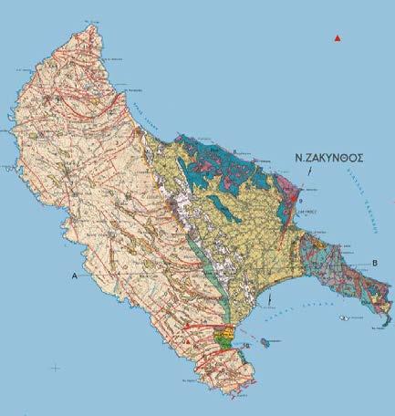
23 Issue No. 10, November GEOLOGICAL MAP OF ZAKYNTHOS ISLAND From Lekkas (1993)
24 Issue No. 10, November GEOTECTONIC UNITS AND TECTONIC STRUCTURE OF ZAKYNTHOS ISLAND From Lekkas (1993), Neotectonic Map of Zakynthos Island
25 Issue No. 10, November TECTONIC STRUCTURE OF ZAKYNTHOS ISLAND Faults in Zakynthos Island Classification of faults based on their throw From Lekkas (1993), Neotectonic Map of Zakynthos Island
26 Issue No. 10, November DRAINAGE SYSTEM AND INCISION ZONES IN ZAKYNTHOS ISLAND Drainage system Incision zones From Lekkas (1993), Neotectonic Map of Zakynthos Island
27 Issue No. 10, November MORPHOLOGICAL DISCONTINUITIES AND PLANATION SURFACES IN ZAKYNTHOS ISLAND Morphological discontinuities Planation surfaces due to deposition and erosion From Lekkas (1993), Neotectonic Map of Zakynthos Island
28 Issue No. 10, November ACTIVE FAULTS IN ZAKYNTHOS ISLAND AND PERIOD OF ACTIVATION From Lekkas (1993), Neotectonic Map of Zakynthos Island
29 Issue No. 10, November MAIN ACTIVE FAULT ZONES AND NEOTECTONIC FAULT BLOCKS IN ZAKYNTHOS ISLAND From Lekkas (1993), Neotectonic Map of Zakynthos Island


30 Issue No. 10, November NEOTECTONIC MAP OF ZAKYNTHOS ISLAND From Lekkas (1993)


31 Issue No. 10, November


32 Issue No. 10, November GEOLOGY OF ZAKYNTHOS ISLAND From Institute of Geology and Mineral Explorations (1983)


33 Issue No. 10, November IONIAN GEOTECTONIC UNIT Lithostratigraphic column of Ionian geotectonic unit From Karakitsios and Rigakis (2007), Journal of Petroleum Geology Triassic to Quaternary stratigraphic column for the Ionian unit From Kokinou et al., 2005, Journal of Petroleum Geology

34 Issue No. 10, November PAXOI GEOTECTONIC UNIT Lithostratigraphic column of Paxoi geotectonic unit From Karakitsios and Rigakis (2007), Journal of Petroleum Geology
 Lekkas (1993) Areas prone to tsunamis, landslides and rockfalls,")
35 Issue No. 10, November AREAS PRONE TO NATURAL DISASTERS IN ZAKYNTHOS ISLAND Lekkas (1994) Lekkas (1993) Areas prone to tsunamis, landslides and rockfalls, liquefaction phenomena, soil flows and forest fires From Lekkas (1993), Neotectonic Map of Zakynthos Island Lekkas (1994), Bulletin of the Geological Society of Greece
36 Issue No. 10, November FAULT BLOCKS IN ZΑKYNTHOS ISLAND From Lekkas (1993), Neotectonic Map of Zakynthos Island


37 FAULT BLOCKS IN ZΑKYNTHOS ISLAND Issue No. 10, November


38 Issue No. 10, November EARTHQUAKE (Χ) 1893 EARTHQUAKE (IΧ)
39 Issue No. 10, November SEISMICITY AND SEISMIC SOURCES IN ZAKYNTHOS GREATER AREA A VII 1759 VIII 1867 IX 1658 X L A3 L A2 L Depth (km) 0-15 Magnitude M = M = 4.0 > X X 1766 IX 1729 VIII 1752 VIII 1714 VIII 1554 VIII From Voulgaris (2002) X IX 1592 IX ΖΑΚΥΝΘΟΣ IX M = 7.2 IX VIII X IX M = VIII VII VIII XIX IX VIII 1514 VIII

40 Issue No. 10, November SEISMICITY AND SEISMIC SOURCES IN ZAKYNTHOS GREATER AREA New seismogenic zonation of Ionian islands, Kyparissiakos gulf and western Peloponnese and major tectonic lineaments associated to seismogenic faultsand earthquakes with Mw 6.0 From SEAHELLARC Working Group (2014), Bollettino di Geofisica Teorica ed Applicata
 37.90 37.80 37.70 ΖΑΚΥΝΘΟΣ 37.90 37.80 37.70 28 26 24 22 20 18 16 Velocity (cm/sec) 37.90 37.80 37.70 ΖΑΚΥΝΘΟΣ 37.90 37.80 37.70 13 12 11 10 9 8 7 Displacement (cm) 230 14 6 37.")
 map for exceeded probability of 10% in 50 years 20.60 20.70 20.80 20.90 21.00 21.10 38.00 38.00 37.50 37.50 20.60 20.70 20.80 20.90 21.00 21.10 PGD (cm) map for exceeded probability of 10% in 50 years 20.")
 37.50 37.50 20.60 20.70 20.80 20.90 21.00 21.")
41 Issue No. 10, November From Voulgaris (2002) PEAK GROUND-MOTION PARAMETERS FOR ZAKYNTHOS ISLAND ΖΑΚΥΝΘΟΣ Acceleration (cm/sec/sec) ΖΑΚΥΝΘΟΣ Velocity (cm/sec) ΖΑΚΥΝΘΟΣ Displacement (cm) PGA (cm/sec 2 ) map for exceeded probability of 10% in 50 years PGV (cm/sec) map for exceeded probability of 10% in 50 years PGD (cm) map for exceeded probability of 10% in 50 years ΖΑΚΥΝΘΟΣ Acceleration (cm/sec/sec) ΖΑΚΥΝΘΟΣ Velocity (cm/sec) ΖΑΚΥΝΘΟΣ Displacement (cm) PGA (cm/sec 2 ) map for exceeded probability of 10% in 100 years PGV (cm/sec) map for exceeded probability of 10% in 100 years PGD (cm) map for exceeded probability of 10% in 100 years

42 Issue No. 10, November HORIZONTAL AND VERTICAL DEFORMATION OF ZAKYNTHOS ISLAND FOR THE PERIOD FROM AUGUST 2005 TO JULY 2006 Large-magnitude earthquakes that occurred offshore to the south in October 2005 and April 2006 most likely contributed to the observed deformation as deduced from DGPS measurements for an encompassing period (August 2005 to July 2006). The largest amount of horizontal deformation occurred in the south, where its western part moved in a W NW direction, while the eastern part moved towards the NE, with magnitudes ranging from 15 to 26 mm. The southern part of the island uplifted a maximum of 65 mm whereas the north subsided from 12 to 28 mm. From Lagios et al. (2007) Tectonophysics

 of the Zakynthos Island GPS network")
43 Issue No. 10, November HORIZONTAL AND VERTICAL DISPLACEMENT OF ZAKYNTHOS ISLAND FOR THE PERIOD FROM Horizontal and Vertical displacement (mm) of the Zakynthos Island GPS network observed for the period (a) and (b) (ITRF2008)
 From Mavroulis et al.")
44 Issue No. 10, November SEISMIC ZONES IN IONIAN ISLANDS Zakynthos falls in the third seismic zone of Greece which is characterized by a ground acceleration coefficient of 0.36g corresponding to the greatest seismic strength demand according to the Greek code for Seismic Resistant Structures From Earthquake Planning and Protection Organization (2003) From Mavroulis et al. (2017), 16 th WCEE

45 Issue No. 10, November HISTORICAL SEISMICITY OF IONIAN ISLANDS Significant historical and instrumentally recorded earthquakes and epicenters that affected the geodynamic evolution of the Ionian Islands From Lekkas et al. (2018), Geotechnical and Geological Engineering


46 THE OCTOBER 26, 2018 ZAKYNTHOS EARTHQUAKE Issue No. 10, November
47 Issue No. 10, November RECORDED TIME-HISTORIES OF ACCELERATION, VELOCITY AND DISPLACEMENT Zakynthos City Keri
48 MOMENT TENSOR SOLUTION OF THE 2018 ZAKYNTHOS EARTHQUAKE Issue No. 10, November

49 COULOMB STRESS CHANGE AND VETRICAL DISPLACEMENT OF THE 2018 ZAKYNTHOS EARTHQUAKE Issue No. 10, November

50 GROUND DEFORMATION OF THE 2018 ZAKYNTHOS EARTHQUAKE Issue No. 10, November

51 Issue No. 10, November COSEISMIC GROUND DEFORMATION OF THE 2018 ZAKYNTHOS EARTHQUAKE Type: co-seismic Master: :39:26 Slave: :40:08 Orbit Number: 80 Mode: DESCENDING

52 Issue No. 10, November COSEISMIC GROUND DEFORMATION OF THE 2018 ZAKYNTHOS EARTHQUAKE Type: co-seismic Master: :31:29 Slave: :30:56 Orbit Number: 175 Mode: ASCENDING

53 Issue No. 10, November PRE-SEISMIC AND POST-SEISMIC GROUND DEFORMATION OF THE 2018 ZAKYNTHOS EARTHQUAKE Type: pre-seismic Master: :39:55 Slave: :39:13 Orbit Number: 73 Mode: ASCENDING Type: co-seismic Master: :39:55 Slave: :39:13 Orbit Number: 73 Mode: ASCENDING

54 INTERFEROGRAM FOR THE 2018 ZAKYNTHOS EARTHQUAKE Issue No. 10, November


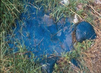
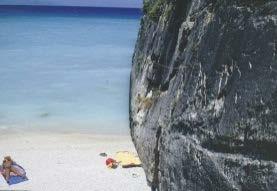
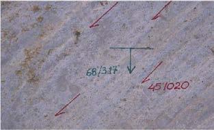
55 SLOPE FAILURES INDUCED BY THE 2018 ZAKYNTHOS EARTHQUAKE Issue No. 10, November


56 Issue No. 10, November SLOPE FAILURES INDUCED BY THE 2018 ZAKYNTHOS EARTHQUAKE


57 Issue No. 10, November SLOPE FAILURES INDUCED BY THE 2018 ZAKYNTHOS EARTHQUAKE


58 SLOPE FAILURES INDUCED BY THE 2018 ZAKYNTHOS EARTHQUAKE Issue No. 10, November

59 Issue No. 10, November TSUNAMI INDUCED BY THE 2018 ZAKYNTHOS EARTHQUAKE
 INDUCED BY THE 2018")
60 Issue No. 10, November VARIATIONS IN SEA LEVEL OBSERVED AT THE SEA OF KATAKOLO (WESTERN PELOPONNESE) INDUCED BY THE 2018 ZAKYNTHOS EARTHQUAKE
, arrival times on")
.")
61 Issue No. 10, November TSUNAMI INDUCED BY THE 2018 ZAKYNTHOS EARTHQUAKE Map with earthquake epicenter (red star), arrival times on coasts and alert levels (red, yellow and green colored triangles). Variations in sea level observed at the sea of Le Castella, in the province of Crotone (station managed by INGV, ISPRA and JRC). The long variations due to the tide and those with the highest frequency are noticed in the early hours of October 26 th.

62 Issue No. 10, November TSUNAMI INDUCED BY THE 2018 ZAKYNTHOS EARTHQUAKE 0 min 10 min 20 min 30 min 40 min 50 min 60 min 70 min

63 Issue No. 10, November Dr. Efthymis Lekkas Professor of Dynamic, Tectonic & Applied Geology & Natural Disaster Management President of the Earthquake Planning and Protection Organization THE Mw 6.8 OCTOBER 26, 2018 ZAKYNTHOS (IONIAN SEA, GREECE) EARTHQUAKE Director of the Post Graduate Program Environmental, Disaster, and Crises Management Strategies PhD c. Spyridon Mavroulis Geologist MSc Prevention & Management of Natural Disasters Zakynthos, 2018
EQUIDAS. The M6.5, Nov 17th 2015, Lefkada earthquake Reconaissance Report. Christos Giarlelis, Christos Mpoutsoras Structural Engineers
 The M6.5, Nov 17th 2015, earthquake Reconaissance Report Christos Giarlelis, Christos Mpoutsoras Structural Engineers December 2015 1. The event The earthquake occurred at 09:10am (07:10 GMT/UTC) November
Seismic Microzonation in Hurghada City (EGYPT)
") Available online at www.sciencedirect.com Procedia Engineering 14 (2011) 2856 2863 The Twelfth East Asia-Pacific Conference on Structural Engineering and Construction Seismic Microzonation in Hurghada
Available online at www.sciencedirect.com Procedia Engineering 14 (2011) 2856 2863 The Twelfth East Asia-Pacific Conference on Structural Engineering and Construction Seismic Microzonation in Hurghada
Tsunami Survey Results in the NPS and Reproduction Analysis Using Tsunami Inversion
 Technical Workshop on the Accident of TEPCO s Fukushima Dai-ichi NPS Tsunami Survey Results in the NPS and Reproduction Analysis Using Tsunami Inversion July 24, 2012 Tomoyuki Tani Agenda 1. Overview of
PRELIMINARY REPORT. The earthquake of January 8, 2013 at SE of Limnos Island, Northern Aegean, Greece I. Kalogeras, N. Melis & C.
 PRELIMINARY REPORT The earthquake of January 8, 2013 at SE of Limnos Island, Northern Aegean, Greece I. Kalogeras, N. Melis & C. Evangelides At 16:16 local time (14:16 GMT) January 8, 2013 a moderate size
The Arequipa (Peru) earthquake of June 23, 2001
 earthquake of June 23, 2001") Journal of Seismology 6: 279 283, 2002. 2002 Kluwer Academic Publishers. Printed in the Netherlands. 279 The Arequipa (Peru) earthquake of June 23, 2001 H. Tavera 1, E. Buforn 2,I.Bernal 1, Y. Antayhua
Journal of Seismology 6: 279 283, 2002. 2002 Kluwer Academic Publishers. Printed in the Netherlands. 279 The Arequipa (Peru) earthquake of June 23, 2001 H. Tavera 1, E. Buforn 2,I.Bernal 1, Y. Antayhua
3-Dimensional Rocking and Sliding Case Histories in the 2014 Cephalonia, Greece Earthquakes
 6 th International Conference on Earthquake Geotechnical Engineering 1-4 November 215 Christchurch, New Zealand 3-Dimensional Rocking and Sliding Case Histories in the 214 Cephalonia, Greece Earthquakes
Preliminary Report. The April 16, 2015 Kasos Earthquake, SE Aegean, Greece Ioannis Kalogeras and Nikolaos S. Melis
 Preliminary Report The April 16, 2015 Kasos Earthquake, SE Aegean, Greece Ioannis Kalogeras and Nikolaos S. Melis National Observatory of Athens, Institute of Geodynamics On April 16, 2015, at 18:07 UTC,
BRIEF INFORMATION ON THE RECORDS
 BRIEF INFORMATION ON THE RECORDS OF THE ITSAK-EPPO ACCELEROMETRIC NETWORK IN SSW AEGEAN SEA OF THE EARTHQUAKES OF SEPTEMBER 2012 On September 12, 2012 (03:27 GMT) a strong earthquake occurred off the southwestern
Response to Tsunami Disaster -the Great East Japan Earthquake 2011-
 Response to Tsunami Disaster -the Great East Japan Earthquake 2011- JAPAN COAST GUARD Hydrographic and Oceanographic Department (JHOD) Outline I. Response to Tsunami Disaster 2011 II. International meeting
Earthquake and Tsunami Risk management in GREECE
 Earthquake and Tsunami Risk management in GREECE C. GOUNTROMICHOU Geologist MSc, PM Head of Emergency Planning Prevention Dept., EARTHQUAKE PLANNING AND PROTECTION ORGANIZATION (E.P.P.O.) HELLENIC MINISTRY
Geomorphology. Glacial Flow and Reconstruction
 Geomorphology Glacial Flow and Reconstruction We will use simple mathematical models to understand ice dynamics, recreate a profile of the Laurentide ice sheet, and determine the climate change of the
Blocking Sea Intrusion in Brackish Karstic Springs
 European Water 1/2: 17-23, 3. 3 E.W. Publications Blocking Sea Intrusion in Brackish Karstic Springs The Case of Almiros Spring at Heraklion Crete, Greece A. Maramathas, Z. Maroulis, D. Marinos-Kouris
Submission of REPUBLICA ORIENTAL DEL URUGUAY. to the COMMISSION ON THE LIMITS OF THE CONTINENTAL SHELF
 Submission of REPUBLICA ORIENTAL DEL URUGUAY to the COMMISSION ON THE LIMITS OF THE CONTINENTAL SHELF pursuant to provisions of article 76, paragraph 8, of the United Nations Convention on the Law of the
The Maltese Islands: Geography
 The Maltese Islands: Geography The Maltese Archipelago comprises a group of small low islands aligned in a NW-SE direction. At their extreme points the Maltese Islands fall within the following points:
 Quaternary Research for Extreme Natural Hazards: Lessons from March 11, 2011 Earthquake and Tsunami Koji Okumura (Hiroshima University) March 11, 2011 Tohoku Earthquake and Tsunamis fatalities missing
V. Kouskouna 1, K. Sesetyan 2, M. Stucchi 3 1. Department of Geophysics and Geothermics, University of Athens, Greece 2
 The 1933 Kos earthquake: a preliminary study V. Kouskouna 1, K. Sesetyan 2, M. Stucchi 3 1 Department of Geophysics and Geothermics, University of Athens, Greece 2 Kandilli Observatory and Earthquake Research
Shrubs and alpine meadows represent the only vegetation cover.
 Saldur river General description The study area is the upper Saldur basin (Eastern Italian Alps), whose elevations range from 2150 m a.s.l. (location of the main monitoring site, LSG) and 3738 m a.s.l.
Republika e Kosovës Republika Kosova-Republic of Kosovo Qeveria-Vlada-Government KOSOVO GEOLOGICAL SURVEYS
 Republika e Kosovës Republika Kosova-Republic of Kosovo Qeveria-Vlada-Government KOSOVO GEOLOGICAL SURVEYS Zagreb 22 October, 2015 Geological-Geotectonic Setting From the geological point of view, Kosovo
R/V Kairei Cruise Report KR Seismic study in the Japan Trench region. Dec. 10, 2012 Jan. 8, 2013
 R/V Kairei Cruise Report KR12-20 Seismic study in the Japan Trench region Dec. 10, 2012 Jan. 8, 2013 Japan Agency for Marine-Earth Science and Technology (JAMSTEC) Contents: 1.Cruise Information: 2.Researchers
CORALFISH 2010 Cruise Report: CF0910-ROV. Eastern Ionian, Cephalonia Island
 CORALFISH 2010 Cruise Report: CF0910-ROV 24 29 th September 2010 Eastern Ionian, Cephalonia Island Dr. Chris Smith & Shipboard Scientific Crew Hellenic Centre for Marine Research CoralFISH: EU Project
Monitoring the marine environment
 Monitoring the marine environment D. Velaoras & E. Krasakopoulou Hellenic Center for Marine Research (HCMR) Seasera Mediterranean Workshop 27-28 September 2012 Ifremer Toulon POSEIDON multi parametric
GC 225 Lecture Exam #2
 GC 225 Lecture Exam #2 Direction- path along which something is moving. 3 Types; - COMPASS DIRECTIONAL NAME (32 in total) - BEARING (four 0 o - 90 o ) - AZIMUTHS (0 o - 360 o ) Compass (32 named points)
CORALFISH 2009 Cruise Report: CF0609. Eastern Ionian, Cephalonia and Zakynthos
 CORALFISH 2009 Cruise Report: CF0609 15-25 th June 2009 Eastern Ionian, Cephalonia and Zakynthos Dr. Chris Smith & Shipboard Scientific Crew Hellenic Centre for Marine Research CoralFISH: EU Project 213144,
Profiling Float Observations in the Aegean Sea
 Profiling Float Observations in the Aegean Sea Sarantis S. Sofianos University of Athens, Department of Applied Physics Ocean Physics and Modelling Group University Campus, BUILD PHYS-5 Athens 15784, GREECE
P-46 The Karstic system of the Kerketio Mountain (Koziakas) and its exploitation. by George Bathrellos*, Efthimia Verikiou**, Hariklia Skilodimou***
 and its exploitation. by George Bathrellos*, Efthimia Verikiou**, Hariklia Skilodimou***") P-46 The Karstic system of the Kerketio Mountain (Koziakas) and its exploitation. by George Bathrellos*, Efthimia Verikiou**, Hariklia Skilodimou*** Abstract The Kerketio or Koziakas Mountain is the eastern
P-46 The Karstic system of the Kerketio Mountain (Koziakas) and its exploitation. by George Bathrellos*, Efthimia Verikiou**, Hariklia Skilodimou*** Abstract The Kerketio or Koziakas Mountain is the eastern
Natural and man-made flooding hazards at the torrents in the town of Thessaloniki
 Risk Analysis VII PI-373 Natural and man-made flooding hazards at the torrents in the town of Thessaloniki S. Stefanidis, F. Tziaftani & C. Chatzicristaki Institute of Mountainous Water Management and
ARTIFICIAL RECHARGE OF THE UNDERGROUND KARSTIC AQUIFER OF FARSALA AREA (THESSALY, CENTRAL GREECE) 1
 1") ARTIFICIAL RECHARGE OF THE UNDERGROUND KARSTIC AQUIFER OF FARSALA AREA (THESSALY, CENTRAL GREECE) 1 MARIOLAKOS, I. 2, FOUNTOULIS, I., SPYRIDONOS, E., MARIOLAKOS, D., ANDREADAKIS, EM. ABSTRACT The area
ARTIFICIAL RECHARGE OF THE UNDERGROUND KARSTIC AQUIFER OF FARSALA AREA (THESSALY, CENTRAL GREECE) 1 MARIOLAKOS, I. 2, FOUNTOULIS, I., SPYRIDONOS, E., MARIOLAKOS, D., ANDREADAKIS, EM. ABSTRACT The area
along a transportation corridor in
 Rockfall hazard and risk assessment along a transportation corridor in the Nera Valley, Central Italy Presentation on the paper authored by F. Guzzetti and P. Reichenbach, 2004 Harikrishna Narasimhan Eidgenössische
The re-emergence of Greece s Upstream Oil & Gas sector:
 8 th South East Europe Energy Dialogue 12 June 2014 The re-emergence of Greece s Upstream Oil & Gas sector: Hellenic Petroleum experience Yannis Grigoriou E&P D. General Manager Hellenic Petroleum S.A.
Railway-Highway Crossing at Grade Regulations: Guidelines for British Columbia s Provincial Heritage Railways
 Railway-Highway Crossing at Grade Regulations: Guidelines for British Columbia s Provincial Heritage Railways SHORT TITLE 1. These Guidelines may be cited as the Railway-Highway Crossing at Grade Guidelines.
1) Earthquake and Strong Ground Motion Acc.(cm/s/s)
 Earthquake and Strong Ground Motion Acc.(cm/s/s)") Symposium for Recent Earthquakes and Tsunami in Japan and Peru The 211 Tohoku Earthquake and Tsunami: 1) Earthquake and Strong Ground Motion Acc.(cm/s/s) (cm/s/s) Acc.( Acc.(cm/s/s) 2-2 5-5 2-2 Tokachi-oki
Symposium for Recent Earthquakes and Tsunami in Japan and Peru The 211 Tohoku Earthquake and Tsunami: 1) Earthquake and Strong Ground Motion Acc.(cm/s/s) (cm/s/s) Acc.( Acc.(cm/s/s) 2-2 5-5 2-2 Tokachi-oki
HELLENIC NAVY HYDROGRAPHIC SERVICE. XVI th MEDITERRANEAN AND BLACK SEAS HYDROGRAPHIC COMMISSION NATIONAL REPORT OF GREECE
 HELLENIC NAVY HYDROGRAPHIC SERVICE XVI th MEDITERRANEAN AND BLACK SEAS HYDROGRAPHIC COMMISSION NATIONAL REPORT OF GREECE Odessa - Ukraine, 22-24 September 2009 1. Hydrographic Service: General Hellenic
Data Repository Item Lefticariu et al., pg.1
 Data Repository Item Lefticariu et al., pg.1 DR2005009 Table DR1. Stable isotope (δ 13 C (, PDB) and δ 18 O (, SMOW)) data from carbonate host rocks and calcite veins of the Nuncios fold complex. No. Sample
HELLENIC NAVY HYDROGRAPHIC SERVICE. XV th MEDITERRANEAN AND BLACK SEAS HYDROGRAPHIC COMMISSION CONTRIBUTION OF GREECE
 HELLENIC NAVY HYDROGRAPHIC SERVICE XV th MEDITERRANEAN AND BLACK SEAS HYDROGRAPHIC COMMISSION CONTRIBUTION OF GREECE Malta, 22-24 October 2007 1. Hydrographic Office: Hellenic Navy Hydrographic Service
HISTORIC BUILDING PERFORMANCE IN EARTHQUAKE: DAMAGE ON BUILDINGS AND IMPACT OF PREVIOUS INTERVENTIONS
 ENGINEER S SEMINAR: HISTORIC BUILDINGS AND EARTHQUAKE 11-12 DECEMBER 2011, MIKVE ISRAEL, ISRAEL : DAMAGE ON BUILDINGS AND IMPACT OF PREVIOUS INTERVENTIONS THE CASE OF L AQUILA - ITALY SPEAKER: DEPARTMENT
PART 1. EXECUTIVE SUMMARY. English Translation of the Russian Original
 REVISION OF THE PARTIAL SUBMISSION OF THE RUSSIAN FEDERATION TO THE COMMISSION ON THE LIMITS OF THE CONTINENTAL SHELF RELATED TO THE CONTINENTAL SHELF IN THE SEA OF OKHOTSK PART 1. EXECUTIVE SUMMARY English
glacier Little Ice Age continental glacier valley glacier ice cap glaciation firn glacial ice plastic flow basal slip Chapter 14
 Little Ice Age glacier valley glacier continental glacier ice cap glaciation firn glacial ice plastic flow basal slip glacial budget zone of accumulation zone of wastage glacial surge abrasion glacial
MiSP Topographic Maps Worksheet #1a SLOPE AND TOPOGRAPHIC CONTOURS
 MiSP Topographic Maps Worksheet #1a Name Date Introduction: SLOPE AND TOPOGRAPHIC CONTOURS Topographic contours are shown by lines of different widths. Each contour is a line of equal elevation; therefore,
GLACIER STUDIES OF THE McCALL GLACIER, ALASKA
 GLACIER STUDIES OF THE McCALL GLACIER, ALASKA T John E. Sater* HE McCall Glacier is a long thin body of ice shaped roughly like a crescent. Its overall length is approximately 8 km. and its average width
NAME: Sayed Omar Mohamed Hassan Elkhateeb DATE OF BIRTH 9/ 12/ 1957 PLACE OF Qena, Egypt BIRTH SEX:
 Personal information NAME: Sayed Omar Mohamed Hassan Elkhateeb DATE OF BIRTH 9/ 12/ 1957 PLACE OF Qena, Egypt BIRTH SEX: male SOCIAL STATE Married NATIONALTY: TELEPHONE PROFESSION Egyptian HOME: +2096-5330738
Energy from Experience
 Energy from Experience June 2018 GROSSO GROUP MEMBER COMPANY www.argentinalithium.com OTC: PNXLF TSX-V: LIT FSE:OAY2 Forward Looking Statements This Presentation contains forward-looking statements within
Measures for Earthquake-Resistance Enhancement of Industrial Complexes around The Tokyo Bay
 Measures for Earthquake-Resistance Enhancement of Industrial Complexes around The Tokyo Bay Masanori Hamada Waseda University, Tokyo, Japan 2016/1/12 International Symposium on Natural and Technological
THE 2011 VAN EARTHQUAKES OCURRED IN TURKEY
 411 Archi-Cultural Translations through the Silk Road 2nd International Conference, Mukogawa Women s Univ., Nishinomiya, Japan, July 14-16, 2012 Proceedings THE 2011 VAN EARTHQUAKES OCURRED IN TURKEY Baris
MiSP Topographic Maps Worksheet #1a L2
 MiSP Topographic Maps Worksheet #1a L2 Name Date SLOPE AND TOPOGRAPHIC CONTOURS Introduction: Topographic contours are shown by lines of different widths. Each contour is a line of equal elevation; therefore,
Alpine Glacial Features along the Chimney Pond Trail, Baxter State Park, Maine
 Maine Geologic Facts and Localities September, 2009 Alpine Glacial Features along the Chimney Pond Trail, Baxter State Park, Maine 45 54 57.98 N, 68 54 41.48 W Text by Robert A. Johnston, Department of
ALPINE PIPELINE RIVER CROSSINGS 2009 MONITORING REPORT
 ALPINE PIPELINE RIVER CROSSINGS 2009 MONITORING REPORT Submitted to ConocoPhillips Alaska, Inc. Submitted by Michael Baker, Jr., Inc. 1400 West Benson Blvd., Suite 200 Anchorage, Alaska 99503 TABLE OF
MIDDLE SCHOOL CURRICULUM TR AILING ICE AGE M YST ERI E S SEARCHING GLACIAL FEATURES
 MIDDLE SCHOOL CURRICULUM TR AILING ICE AGE M YST ERI E S SEARCHING GLACIAL FEATURES CONTENTS I. Enduring Knowledge... 3 II. Teacher Background... 3 III. Before Viewing the Video... 5 IV. Viewing Guide...
NATIONAL REPORT OF GREECE
 HELLENIC NAVY HYDROGRAPHIC SERVICE 20 th Meeting of Mediterranean and Black Seas Hydrographic Commission (MBSHC) NATIONAL REPORT OF GREECE 4-6July 2017 Herceg Novi, Montenegro 1. Hydrographic Service:
Tsunami Impacting Eastern Japan and Preparedness for Extraordinary Natural Disaster. Takehiko Fujita
 May 25, 2011 Tsunami Impacting Eastern Japan and Preparedness for Extraordinary Natural Disaster Takehiko Fujita Acting President Port and Airport Research Institute, Japan Contents 1. Outline of the earthquake
MARCH 2011, TSUNAMI DISASTER IN JAPAN
 MARCH 2011, TSUNAMI DISASTER IN JAPAN Dr. Neelima Satyam D 1 and Dr. D V Reddy 2 1 Assistant Professor Earthquake Engineering Research Centre International Institute of Information Technology Hyderabad
47I THE LAS ANIMAS GLACIER.
 THE LAS ANIMAS GLACIER. ONE of the largest of the extinct glaciers of the Rocky Mountains was that which occupied the valley of the Las Animas river. This stream originates in the San Juan mountains in
University of Colorado, Colorado Springs Mechanical & Aerospace Engineering Department. MAE 4415/5415 Project #1 Glider Design. Due: March 11, 2008
 University of Colorado, Colorado Springs Mechanical & Aerospace Engineering Department MAE 4415/5415 Project #1 Glider Design Due: March 11, 2008 MATERIALS Each student glider must be able to be made from
Thirteenth International Water Technology Conference, IWTC , Hurghada, Egypt 1249
 Thirteenth International Water Technology Conference, IWTC 13 2009, Hurghada, Egypt 1249 EVALUATION OF LOCAL SCOUR AROUND BRIDGE PIERS (RIVER NILE BRIDGES AS CASE STUDY) Sherine Ismail Assoc. Prof., Survey
FINAL REPORT West Coast Naval Training Range Demonstration of Glider-Based Passive Acoustic Monitoring
 DISTRIBUTION STATEMENT A. Approved for public release; distribution is unlimited. FINAL REPORT West Coast Naval Training Range Demonstration of Glider-Based Passive Acoustic Monitoring John A. Hildebrand
Energy from Experience
 Energy from Experience September 2018 GROSSO GROUP MEMBER COMPANY www.argentinalithium.com OTC: PNXLF TSX-V: LIT FSE:OAY2 Forward Looking Statements This Presentation contains forward-looking statements
TERRESTRIAL S Night Skies & Natural Sounds
 TERRESTRIAL S Night Skies & Natural Sounds INTRODUCTION OBJECTIVES (Background and acoustical monitoring information was taken from the National Park Service website http:// www.nature.nps.gov/sound/assets/docs/interphandbook.pdf)
NOTIFICATION OF PROPOSED RESEARCH CRUISE
 NOTIFICATION OF PROPOSED RESEARCH CRUISE PART A: GENERAL 1. NAME OF RESEARCH SHIP FS POSEIDON CRUISE NO. P303 2. DATES OF CRUISE From: 11/09/2003 To: 06/10/2003 3. OPERATING AUTHORITY Institut fuer Meereskunde
Title. Author(s)ISHII, K.; KIKUCHI, M.; SHIRAI, K. Issue Date Doc URL. Type. Note. File Information HIGASHI-HONGANJI HAKODATE BETSUIN
ISHII, K.; KIKUCHI, M.; SHIRAI, K. Issue Date Doc URL. Type. Note. File Information HIGASHI-HONGANJI HAKODATE BETSUIN") Title STRUCTURAL CHARACTERISTICS OF A HISTORICAL REINFORCE HIGASHI-HONGANJI HAKODATE BETSUIN Author(s)ISHII, K.; KIKUCHI, M.; SHIRAI, K. Issue Date 2013-09-12 Doc URL http://hdl.handle.net/2115/54344 Type
Title STRUCTURAL CHARACTERISTICS OF A HISTORICAL REINFORCE HIGASHI-HONGANJI HAKODATE BETSUIN Author(s)ISHII, K.; KIKUCHI, M.; SHIRAI, K. Issue Date 2013-09-12 Doc URL http://hdl.handle.net/2115/54344 Type
Estuaries of South America
 Gerardo M.E. Perillo Maria Cintia Piccolo Mario Pino-Quivira (Eds.) Estuaries of South America Their Geomorphology and Dynamics With 102 Figures and 20 Tables Springer 1 What Do We Know About the Geomorphology
STUDY OF ALAQI SECONDARY CHANNEL IN LAKE NASSER
 ABSTRACT STUDY OF ALAQI SECONDARY CHANNEL IN LAKE NASSER GamalSallam 1, Mohamed Ihab 2, and Waleed Emary 3 Associate Professor, National Water Research Center, Email: gasallam@yahoo.com Civil Engineer,
Glaciers Earth 9th Edition Chapter 18 Mass wasting: summary in haiku form Glaciers Glaciers Glaciers Glaciers Formation of glacial ice
 1 2 3 4 5 6 7 8 9 10 11 12 13 14 15 Earth 9 th Edition Chapter 18 Mass wasting: summary in haiku form Ten thousand years thence big glaciers began to melt - called "global warming." are parts of two basic
The Hokkaido Earthquake: a (very) preliminary analysis revision 1
 preliminary analysis revision 1") The Hokkaido Earthquake: a (very) preliminary analysis revision 1 September 06, 2018, 03:08 JST Woody Epstein, ARS Where it happened Map of Hokkaido indicating JMA Intensities (Shindo) A First report from
The Hokkaido Earthquake: a (very) preliminary analysis revision 1 September 06, 2018, 03:08 JST Woody Epstein, ARS Where it happened Map of Hokkaido indicating JMA Intensities (Shindo) A First report from
DEPARTMENT: CIVIL ENGINEERING SEMESTER: III SUBJECT CODE / Name: CE2303/ Railway, Airport and Harbors Engineering 2 MARK QUESTIONS AND ANSWERS
 DEPARTMENT: CIVIL ENGINEERING SEMESTER: III SUBJECT CODE / Name: CE2303/ Railway, Airport and Harbors Engineering 2 MARK QUESTIONS AND ANSWERS 1.Define wind Coverage (AUC NOV/DEC 2010),(AUC NOV/DEC 2011)
Taisei MORISHITA, Hiroaki SAITO and Shin TANI Hydrographic and Oceanographic Department (JHOD) Japan Coast Guard
 Japan Coast Guard") Taisei MORISHITA, Hiroaki SAITO and Shin TANI Hydrographic and Oceanographic Department (JHOD) Japan Coast Guard 1. Earthquake and Tsunami (review) 2. JHOD s Response Activities (overview) 3. Hydrographic
Taisei MORISHITA, Hiroaki SAITO and Shin TANI Hydrographic and Oceanographic Department (JHOD) Japan Coast Guard 1. Earthquake and Tsunami (review) 2. JHOD s Response Activities (overview) 3. Hydrographic
MIDDLE SCHOOL CURRICULUM TR AILING ICE AGE M YST ERI E S ICE AGE TREKKING
 MIDDLE SCHOOL CURRICULUM TR AILING ICE AGE M YST ERI E S ICE AGE TREKKING CONTENTS I. Enduring Knowledge... 3 II. Teacher Background... 3 III. Before Viewing this Video... 5 IV. Viewing Guide... 5 V. Discussion
Preliminary Information on the 2003 Tokachi-oki Earthquake
 Preliminary Information on the 2003 Tokachi-oki Earthquake Yohsuke Kawamata and Professor Scott Ashford Department of Structural Engineering University of California, San Diego References for Slides 1,
Chapter 16 Glaciers and Glaciations
 Chapter 16 Glaciers and Glaciations Name: Page 419-454 (2nd Ed.) ; Page 406-439 (1st Ed.) Part A: Anticipation Guide: Please read through these statements before reading and mark them as true or false.
Post tsunami Recovery of Port and Harbor areas in Japan from the 2011 Great East Japan Earthquake Tsunami
 Date : 18 Nov., 2015 Venue : Furama Ballroom 1 SESSION 1 : A Decade of Partnerships in Sustainable Development of the Seas of East Asia: Synergies and Achievements WORKSHOP 1.1 : Managing Risks in Climate
GREAT EARTHQUAKE DISASTER NILIM, JAPAN
 EAST- JAPAN GREAT EARTHQUAKE DISASTER 11 MARCH in 2011 NILIM, JAPAN CONTENTS 1. Outline of the EARTHQUAKE DISASTER 2. History of EARTHQUAKE/TSUNAMI occurred in Japan 3. Disaster Prevention Policy and Strategy
HYDRAULIC DESIGN OF THE TOURISTIC BERTHING IN ASWAN CITY
 HYDRAULIC DESIGN OF THE TOURISTIC BERTHING IN ASWAN CITY Dr. Hossam El-Sersawy Researcher, Nile Research Institute (NRI), National Water Research Center (NWRC), Egypt E-mail: h_sersawy@hotmail.com Dr.
Slope instability along some sectors of the road to La Bufadora
 Landslides 125 Slope instability along some sectors of the road to La Bufadora J. Soares 1, C. García 2, L. Mendoza 3, E. Inzunza 1, F. Jáuregui 4 & J. Obregón 5 1 Engineering Faculty of the Universidad
Dynamic Planet C Test
 Northern Regional: January 19 th, 2019 Dynamic Planet C Test Name(s): Team Name: School Name: Team Number: Rank: Score: Dynamic Planet B/C Glaciers (87 total points) Multiple choice/fill in the blank (23
ORTHOLOGICAL MANAGEMENT OF HYDROLOGICAL RUNOFF BASINS OF THE PREFECTURE OF DRAMA (CURRENT SITUATION PROTECTIVE ACTIONS PERSPECTIVES)
") ORTHOLOGICAL MANAGEMENT OF HYDROLOGICAL RUNOFF BASINS OF THE PREFECTURE OF DRAMA (CURRENT SITUATION PROTECTIVE ACTIONS PERSPECTIVES) This paper presents the torrential environment of the torrents of the
ORTHOLOGICAL MANAGEMENT OF HYDROLOGICAL RUNOFF BASINS OF THE PREFECTURE OF DRAMA (CURRENT SITUATION PROTECTIVE ACTIONS PERSPECTIVES) This paper presents the torrential environment of the torrents of the
Comparison Study between Vault Seismometers and a New Posthole Seismometer
 Comparison Study between Vault Seismometers and a New Posthole Seismometer Presented in Salt Lake City, Utah at the Seismological Society of America s Annual Meeting, April 2013 250 Herzberg Road, Kanata,
Cruise Report. FDS Submarine Channels RV Koca Piri Reis. 9 th -26 th May 2010
 Cruise Report FDS Submarine Channels RV Koca Piri Reis 9 th -26 th May 2010 Flow dynamics and sedimentation in an active submarine channel: a process-product approach Principal Scientist J Peakall 2012
COMPARATIVE STUDY ON WOODEN HOUSE DAMAGE BETWEEN 1995 KOBE EQRTHQUAKE AND 2000 TOTTORI EARTHQUAKE OF JAPAN
 3 th World Conference on Earthquake Engineering Vancouver, B.C., Canada August -6, 24 Paper No. 255 COMPARATIVE STUDY ON WOODEN HOUSE DAMAGE BETWEEN 995 KOBE EQRTHQUAKE AND 2 TOTTORI EARTHQUAKE OF JAPAN
STATE -OF-ART OF GEODESY IN THE REPUBLIC OF MACEDONIA
 STATE -OF-ART OF GEODESY IN THE REPUBLIC OF MACEDONIA Prof. Zlatko Srbinoski PhD Faculty of Civil Engineering Chair for high geodesy VIENNA, JULY 2008 REPUBLIC OF MACEDONIA Center of Balkan Peninsula a2
REPORT OF STUDY TRIP (Niigata & Miyagi Prefectures)
") INTERNATIONAL INSTITUTE OF SEISMOLOGY AND EARTHQUAKE ENGINEERING (IISEE) REPORT OF STUDY TRIP (Niigata & Miyagi Prefectures) 14 17 November 2011 Prepared by: D.Mungunsuren S course (Mongolia) INTRODUCTION
INTERNATIONAL INSTITUTE OF SEISMOLOGY AND EARTHQUAKE ENGINEERING (IISEE) REPORT OF STUDY TRIP (Niigata & Miyagi Prefectures) 14 17 November 2011 Prepared by: D.Mungunsuren S course (Mongolia) INTRODUCTION
NEW OBSERVATIONS ON THE GLACIAL GEOMORPHOLOGY OF LONG ISLAND FROM A DIGITAL ELEVATION MODEL (DEM) Bennington, J Bret,
 Bennington, J Bret,") 1 NEW OBSERVATIONS ON THE GLACIAL GEOMORPHOLOGY OF LONG ISLAND FROM A DIGITAL ELEVATION MODEL (DEM) Abstract Bennington, J Bret, geojbb@hofstra.edu Department of Geology 114 Hofstra University, Hempstead,
1 NEW OBSERVATIONS ON THE GLACIAL GEOMORPHOLOGY OF LONG ISLAND FROM A DIGITAL ELEVATION MODEL (DEM) Abstract Bennington, J Bret, geojbb@hofstra.edu Department of Geology 114 Hofstra University, Hempstead,
Provincial Development and Physical Framework Plan Province of Capiz
 3.2.3 Protection Areas Protection areas (Map 11) which include areas under the categories of NIPAS, Non-NIPAS, environmentally constrained and the military reservations are described as follows: a) NIPAS
Glacial Origins and Features of Long Island
 Glacial Origins and Features of Long Island Interior Coastal Plain Continental Shelf Long Island s Geology 0 Ma Phanerozoic 540 Ma Proterozoic 2500 Ma Archean 3800 Ma Hadean 4600 Ma C M P Geologic Time
SHIP MANAGEMENT SURVEY. July December 2017
 SHIP MANAGEMENT SURVEY July December 2017 INTRODUCTION The Ship Management Survey is conducted by the Statistics Department of the Central Bank of Cyprus and concentrates primarily on transactions between
Characteristics of damage to transportation facilities induced by the ground shaking and the tsunami of the 2011 East Japan mega earthquake
 Characteristics of damage to transportation facilities induced by the ground shaking and the tsunami of the 2011 East Japan mega earthquake Ö. Aydan, Tokai University, Ocean Research Institute, Shizuoka,
Glaciers and Glaciation Earth - Chapter 18 Stan Hatfield Southwestern Illinois College
 Glaciers and Glaciation Earth - Chapter 18 Stan Hatfield Southwestern Illinois College Glaciers Glaciers are parts of two basic cycles: 1. Hydrologic cycle 2. Rock cycle A glacier is a thick mass of ice
REPUBLIC OF SOUTH AFRICA
 REPUBLIC OF SOUTH AFRICA SAN HYDROGRAPHIC OFFICE NATIONAL REPORT TO THE IHO HYDROGRAPHIC COMMISSION ON ANTARCTICA (HCA) 11 TH MEETING, HOBART, AUSTRALIA 05-07 OCTOBER 2011 2 11 TH HCA MEETING REPORT BY
A Guide to the Geology of Lauca National Park
 A Guide to the Geology of Lauca National Park G. Wörner Geowissenschaftliches Zentrum, Goldschmidtstr. 1 37077 Göttingen, Germany, Gwoerne@gwdg.de For those interested learning more about the geology of
Glaciers and Glaciation
 Chapter 18 Lecture Earth: An Introduction to Physical Geology Eleventh Edition Glaciers and Glaciation Tarbuck and Lutgens Glaciers: A Part of Two Basic Cycles A glacier is a thick mass of ice that forms,
c. 1 inch = 0.6 miles e. 1:100,000 f. 1:250,000 f. 1 inch = 4.0 miles
 High School Advance Geology Map Test 2014 Name Use the information on each map to provide the best answer to the questions. Fill in the bubble of the best answer on your answer sheet. Answer questions
A TOPOGRAPHIC FEATURE OF THE HANGING VALLEYS OF THE YOSEMITE.
 A TOPOGRAPHIC FEATURE OF THE HANGING VALLEYS OF THE YOSEMITE. THE larger hanging valleys around the Yosemite valley have topographic features in common that are interesting in themselves, and they likewise
Canterbury Earthquakes 2010/11 Port Hills Slope Stability: Pilot study for assessing life-safety risk from rockfalls (boulder rolls)
") Canterbury Earthquakes 2010/11 Port Hills Slope Stability: Pilot study for assessing life-safety risk from rockfalls (boulder rolls) C.I. Massey D. Heron M.J. McSaveney B. Lukovic GNS Science Consultancy
Canterbury Earthquakes 2010/11 Port Hills Slope Stability: Pilot study for assessing life-safety risk from rockfalls (boulder rolls) C.I. Massey D. Heron M.J. McSaveney B. Lukovic GNS Science Consultancy
Project: Profiling Float Observations in the Aegean Sea
 Project: Profiling Float Observations in the Aegean Sea Cruise I CRUISE REPORT 1. Introduction and objectives The Profiling Float Observations in the Aegean Sea - Cruise I experiment is a joint effort
2012. Proceedings of the 11 European Geoparks Conference. AGA Associação Geoparque Arouca, Arouca, 5-6.
 References to this volume It is suggested that either the following alternatives should be used for future bibliographic references to the whole or part this volume: th Sá, A.A., Rocha, D., Paz, A. & Correia,
Structure of Puy de Dôme volcano (Chaîne des Puys, France): towards a revised model
: towards a revised model") Structure of Puy de Dôme volcano (Chaîne des Puys, France): towards a revised model D. Miallier 1, P. Boivin 2, C. Deniel 2, A. Gourgaud 2 1 - Clermont Université, Université d Auvergne, Laboratoire de
Structure of Puy de Dôme volcano (Chaîne des Puys, France): towards a revised model D. Miallier 1, P. Boivin 2, C. Deniel 2, A. Gourgaud 2 1 - Clermont Université, Université d Auvergne, Laboratoire de
GLOFs from moraine-dammed lakes: their causes and mechanisms V. Vilímek, A. Emmer
 GLOFs from moraine-dammed lakes: their causes and mechanisms V. Vilímek, A. Emmer Department of Physical Geography and Geoecology, Faculty of Science, Charles University, Prague, Czech Republic vilimek@natur.cuni.cz
THE HYDROGRAPHIC AND TOPOGRAPHIC BRIGADE OF THE SEYCHELLES COAST GUARD REPORT FOR 2008 SAIHC7-5.3I
 THE HYDROGRAPHIC AND TOPOGRAPHIC BRIGADE OF THE SEYCHELLES COAST GUARD REPORT FOR 2008 SAIHC7-5.3I CONTENT 1. GENERAL 2. S55 UPDATE 3. SURVEYS 4. NEW CHARTS & UPDATES 5. NEW PUBLICATIONS & UPDATES 6. MARITIME
The search results explanations of hydrological data
 Introduction The search results explanations of hydrological data Depending on the parameter, the instrumental measuring or visual observation method is used for the hydrological observations. Instrumentally
How to develop resilient infrastructure (Global SDG9)
") How to develop resilient infrastructure (Global SDG9) 16-17 November 2017, Ljubljana, Slovenia Development of resilient rail infrastructure, practices in the Republic of Macedonia Darko Miceski Viktorija
How to develop resilient infrastructure (Global SDG9) 16-17 November 2017, Ljubljana, Slovenia Development of resilient rail infrastructure, practices in the Republic of Macedonia Darko Miceski Viktorija
Port Hedland South-West Creek Dredge Plume Modelling Final Report Version 4 Prepared for Port Hedland Port Authority
 Port Hedland South-West Creek Dredge Plume Modelling Final Report Version 4 Prepared for Port Hedland Port Authority 12 References AME (2010). PHPA South West Creek Approvals Initial Plume Modelling Input.
The contribution of Tourism to the Greek economy in 2017
 The contribution of Tourism to the Greek economy in 2017 1 st edition (provisional data) May 2018 Dr. Aris Ikkos, ISHC Research Director Serafim Koutsos Analyst INSETE Republishing is permitted provided
Report on Field Survey of Solomon Islands Earthquake Tsunami in April 2007
 Report on Field Survey of Solomon Islands Earthquake Tsunami in April 2007 by Takashi Tomita 1, Taro Arikawa 2, Daisuke Tatsumi 3, Kazuhiko Honda 3, Hiroshi Higashino 4 Kazuya Watabnabe 4, and Shigeo Takahashi