Structure of Puy de Dôme volcano (Chaîne des Puys, France): towards a revised model
|
|
|
- Melanie Whitehead
- 6 years ago
- Views:
Transcription
: towards")


1 Structure of Puy de Dôme volcano (Chaîne des Puys, France): towards a revised model D. Miallier 1, P. Boivin 2, C. Deniel 2, A. Gourgaud Clermont Université, Université d Auvergne, Laboratoire de Physique Corpusculaire, CNRS/IN2P3 2 - Clermont Université, Université Blaise Pascal, Laboratoire Magmas et Volcans, OPGC-CNRS, J.P. Soissons 1
2 Puy de Dôme : 1st experimental test site for the TOMUVOL* project Criteria for this choice : - simple and open outline - but complex internal structure - proximity from the Clermont laboratories (~ 8 km ; 20 min drive) *TOMUVOL : Tomography with Muons for Volcanoes 2
 Aim of the present talk : expose the geological baseline and the")
3 Puy de Dôme : 1st experimental test site for the TOMUVOL project Criteria for this choice : - simple and open outline - but complex internal structure - proximity from the Clermont laboratories (~ 8 km ; 20 min drive) Aim of the present talk : expose the geological baseline and the issues 3


4 J.P. Soissons Chaîne des Puys : - Small intraplate volcanic field - ~80 single monogenic volcanoes - Continuous petrographic series from basic to acidic magma 4
5 Morphologies of volcanoes controlled by : -Magma nature - Eruption dynamics -Preexisting relief - Presence (or absence) of sub-surface water 5
 of sub-surface")

6 Morphologies of volcanoes controlled by : -Magma nature - Eruption dynamics -Preexisting relief - Presence (or absence) of sub-surface water Pariou, ~ 10 ka Fluid magma (basaltic s.l.): cone, crater and long lava flows Cliersou, ka Viscous magma (trachytic): lava - dome 6
7 A case study : Puy de Dôme Lidar survey CRAIG GEOPHENIX 2012 Scientific control by P. Labazuy Magma: trachyte (~ 67 % SiO2) 7
8 1465 m a.s.l 1800 m 400 m 8
9 Seems to be composed of two distinct edifices 9
10 Western edifice : bristle lava dome with ridges and pinacles 10


11 Anak Ranaka, indonesia Western edifice : bristle lava dome with ridges and pinacles A. Gourgaud 11


12 Eastern edifice: Regular cone, the basis of which is covered by thick layers of deposits Ash-and-block flow in the slopes Ash-and-block flow at the foot 12
13 Proposed interpretation (before 2004) 1 11 ka ago: construction of the dome 2 Flank collapse 3 Erection of a new dome in the opened flank 13

14 Proposed interpretation (before 2004) 1 11 ka ago: construction of the dome 2 Flank collapse Historical example : Montagne Pelée Erection of a new dome in the opened flank 14
15 Oversimplified sketch 15

16 Dome no 2 Dome no 1 16

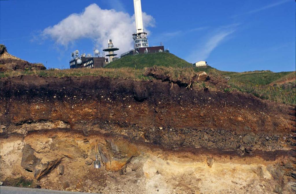

17 New data (since 2004) Excavations new outcrops new questions 17
 Soil Unknown tephra Puy de Dôme surface deposits (11")
18 Soil Kilian* deposits (9.45 ka) Soil Unknown tephra Puy de Dôme surface deposits (11 ka) * Kilian is a neighbour volcano 18
19 Puy de Dôme lava mixed with allogeneous lithics and various country rocks. Unknown tephra Grain size distribution + lithics phreatomagmatic eruption of Puy de Dôme itself Radiocarbon Age ~ 10.7 ka 19

20 Interpretation - continued 3 11 ka: end of main eruption ka: summit eruption through an open vent ka Kilian eruption (not represented here) 6 Today 20
21 ? 21

22 ? Multicolored lapilli: trachytic lapilli altered by hydrothermal and fumarole action 22


23 Evidence for fumarole activity along fissures atop the dome Staining and silicification of the lava Fumaroles connected with past hydrothermalism in the dome? 23
24 ?? Late eruption triggered or enhanced by water absorbed in the bulk of the porous dome? 24
25 ? Late eruption triggered or enhanced by water absorbed in the bulk of the porous dome? Historical example : La Souffrière lava dome (Guadeloupe), 1690 AD 25
26 A new puzzling observation Long and thick slabs of massive lava laying on the southern flank (looking different in shape from the western ridges)

27 Marks suggest linear elongation ~ 6m The slabs lay on loose deposits of ashes 27
28 Did Puy de Dôme produce real lava flows? 28
29 Did Puy de Dôme produce real lava flows? Scar produced by collapse of the lava flows 29
30 Last: limits of the ash-and-block flows LiDAR survey CRAIG GEOPHENIX 2012, Scientific control by P. Labazuy 30
31 Limits not significantly larger on the eastern part of the volcano than on its western part 31
")
32 Limits not significantly larger on the eastern part of the volcano than on its western part Does not support the hypothesis of an important flank collapse (as on the classical Puy de Dôme model) 32
33 Conclusions History of Puy de Dôme more complex than for a simple lava-dome. Former dual dome model is questionned Geophysical investigation wanted for elucidating its inner structure Reciprocally, Puy de Dôme volcano is a good target for testing the geophysical methods, including muon tomography 33


34 Thank you for your attention Puy-de-Dôme, end of XIX th century Archives départementales du Puy-de-Dôme 34
Table A.7.1 Input Data for Geothermal Database
 APPENDIX-7 DATABASE Table A.7.1 Input Data for Geothermal Database *Well Data includes location, curve, casing program, geological column and permeable zone, etc. BGR: Bundesanstalt für Geowissenschaften
Meet the world s newest glacier at Mount St. Helens
 Meet the world s newest glacier at Mount St. Helens By Seattle Times, adapted by Newsela staff on 08.10.15 Word Count 733 Hikers walk past this chunk of the volcano that existed before May 18, 1980. The
Muography on Puy de Dôme. C Cârloganu LPC Clermont Ferrand IN2P3/CNRS
 Muography on Puy de Dôme C Cârloganu LPC Clermont Ferrand IN2P/CNRS Proof of principle of muography on km sized volcanoes Puy de Dôme muography reference site Institute of Nuclear Physics of Lyon Proof
VOLCANO DISCOVERY 5 days
 5 days Countries visited Philippines Tour Highlights Trek to Mount Pinatubo Take a boat to Lake Taal's inner volcano Witness smoking Mount Mayon - the perfect conical volcano Places visited Legazpi Tagaytay
A Guide to the Geology of Lauca National Park
 A Guide to the Geology of Lauca National Park G. Wörner Geowissenschaftliches Zentrum, Goldschmidtstr. 1 37077 Göttingen, Germany, Gwoerne@gwdg.de For those interested learning more about the geology of
4. Bronze Age Ballybrowney, County Cork Eamonn Cotter
 4. Bronze Age Ballybrowney, County Cork Eamonn Cotter Illus. 1 Location map of the excavated features at Ballybrowney Lower (Archaeological Consultancy Services Ltd, based on the Ordnance Survey Ireland
Last eruption was in 1909.
 Teide National Park Where is it?: El Teide is a giant volcano, that occupies the island of Tenerife, whose coasts are bathed by the Atlantic Ocean. It is in the Canary Islands, off the northwest coast
IMTO Italian Mission to Oman University of Pisa 2011B PRELIMINARY REPORT (OCTOBER-DECEMBER 2011)
") IMTO Italian Mission to Oman University of Pisa 2011B PRELIMINARY REPORT (OCTOBER-DECEMBER 2011) The 2011B research campaign took place in the area around Salut from October, 19 th, to December, 16 th.
IMTO Italian Mission to Oman University of Pisa 2011B PRELIMINARY REPORT (OCTOBER-DECEMBER 2011) The 2011B research campaign took place in the area around Salut from October, 19 th, to December, 16 th.
Mount Meru Hiking / Climb
 Mount Meru Hiking / Climb Mount Meru is the second highest mountain in Tanzania and the fifth highest in Africa. Mount Meru is an active volcano located 70 kilometres (44 miles) west of Mount Kilimanjaro.
Excavations in a Medieval Market Town: Mountsorrel, Leicestershire,
 Excavations in a Medieval Market Town: Mountsorrel, Leicestershire, by John Lucas Mountsorrel is situated 12 kms north of Leicester and forms a linear settlement straddling the A6, Leicester to Derby road.
ARDESTIE EARTH HOUSE HISTORIC ENVIRONMENT SCOTLAND STATEMENT OF SIGNIFICANCE. Property in Care no: 24
 Property in Care no: 24 Designations: Scheduled Monument (SM90021) Taken into State care: 1953 (Guardianship) Last reviewed: 2004 HISTORIC ENVIRONMENT SCOTLAND STATEMENT OF SIGNIFICANCE ARDESTIE EARTH
Sao Miguel Island Land Tours
 O U R T O P 4 M U S T S E E A R E A S O F S A O M I G U E L I S L A N D, A Z O R E S Sao Miguel Island Land Tours 1. SETE CIDADES WALKING, BIKE OR JEEP TOUR 2. LAGOA DO FOGO & CALDEIRA VELHA JEEP TOUR
(RE)CONSTRUCTION OF TRADITIONAL ARCHITECTURE IN SANTORINI ISLAND, GREECE
CONSTRUCTION OF TRADITIONAL ARCHITECTURE IN SANTORINI ISLAND, GREECE") (RE)CONSTRUCTION OF TRADITIONAL ARCHITECTURE IN SANTORINI ISLAND, GREECE Santorini is the southern island of the Cyclades, with a surface of 75 sq. km and is part of a volcanic basin composed by three
(RE)CONSTRUCTION OF TRADITIONAL ARCHITECTURE IN SANTORINI ISLAND, GREECE Santorini is the southern island of the Cyclades, with a surface of 75 sq. km and is part of a volcanic basin composed by three
Pion misidentification in several IFR configurations
 Pion misidentification in several IFR configurations Francesco Fabozzi Università degli Studi di Napoli Federico II INFN Sezione di Napoli Introduction Several configurations proposed for an IFR upgrade
SYNOPSIS WEATHER AND SNOWPACK
 Peak 6996 Avalanche Fatality Incident Report Glacier National Park, MT Date of Avalanche: 31 March 2010 Date of Investigation: 2 April 2010 Investigation Team: Erich Peitzsch (USGS), Ted Steiner (Chugach
Architectural Analysis in Western Palenque
 Architectural Analysis in Western Palenque James Eckhardt and Heather Hurst During the 1999 season of the Palenque Mapping Project the team mapped the western portion of the site of Palenque. This paper
Volcano Above the Clouds
 Volcano Above the Clouds PROGRAM OVERVIEW NOVA joins climbers scaling Mount Kilimanjaro as they travel through ecosystems ranging from a cloud forest to a glaciated mountaintop. The program: chronicles
FEEL REBORN HERE FAM TRIP GREEN FRANCE. Hikking in the Auvergne volcanoes. The following program is subject to changes.
 M a y 2 0 1 9 FAM TRIP GREEN FRANCE Hikking in the Auvergne volcanoes The following program is subject to changes https://www.greenfrance.org/ IDEAL LOCATION IN FRANCE EASY ACCESS A region at the heart
Big Island Hawaii Explorer
 # 1933 Hawaii s Big Island is not only big in size, but also in diversity. There are snowy mountaintops, lush jungles, windswept grasslands, picturesque beaches, and lava fields - you can see all these
1.1.1 Landscape character This is the upper part of a bowl-shaped landform, extending east from the Rothiemurchus character area, contained by the
 1.1 Glen More 1.1.1 Landscape character This is the upper part of a bowl-shaped landform, extending east from the Rothiemurchus character area, contained by the arc of the high granite pluton of the Cairngorms
For more information about trips, itineraries, costs and dates please
 SURVIVING & SUSTAINABILITY - SUMATRA A Science, Humanities & Service Adventure in Central Sumatra For Round Square Conference Delegates (Oct. 9-13, 2015) For more information about trips, itineraries,
L Atmosphère. NOx measurements at Puy de Dome
 L Atmosphère NOx measurements at Puy de Dome Aurélie COLOMB «CO-PDD» History of the PUY atmospheric research station 1871 : Emile Alluard, professor at the University of Clermont- Ferrand Construction
Amarna Workers Village
 Amarna Workers Village The Egyptian city of Amarna was the pet building project of the pharaoh Akhenaten, who oversaw construction of his new capital between 1346 and 1341 BCE. The city was largely abandoned
FRANCE : HOW TO IMPROVE THE AVALANCHE KNOWLEDGE OF MOUNTAIN GUIDES? THE ANSWER OF THE FRENCH MOUNTAIN GUIDES ASSOCIATION. Alain Duclos 1 TRANSMONTAGNE
 FRANCE : HOW TO IMPROVE THE AVALANCHE KNOWLEDGE OF MOUNTAIN GUIDES? THE ANSWER OF THE FRENCH MOUNTAIN GUIDES ASSOCIATION ABSTRACT : Alain Duclos 1 TRANSMONTAGNE Claude Rey 2 SNGM The French Mountain Guides
There are actually six geographic sub-regions, three in both the uplands and the lowlands.
 6 Regions of AR Although Arkansas is most easily divided into two distinct geographical regions, the northwestern uplands and the southeastern lowlands, this description does not accurately portray the
Bureau of Land Management Public Lands Guide Northwest District
 Bureau of Land Management Public Lands Guide Northwest District NORTHWEST Fee Site Restrooms Picnic Sites Developed Campgrounds Farmington Field Office (505) 564-7600 Alien Run Mountain Bike Trail Angel
The Coach House, Mill Lane, Cookham, Berkshire
 The Coach House, Mill Lane, Cookham, Berkshire An Archaeological Watching Brief For Ms Sophia Butler by Stephen Hammond Thames Valley Archaeological Services Ltd Site Code CMC 03/104 October 2003 Summary
Combined tour to Kamchatka
 The land of active volcanoes Combined tour to Kamchatka The blue of the Avachinsky Bay and the "dead forest" covered with ashes, geysers pouring from the bowels of the earth and volcanoes rising to the
Project,,International mobility - the opportunity of progress and innovation to professional excellence
 Program Erasmus+ KA1 action Project,,International mobility - the opportunity of progress and innovation to professional excellence Traineeship in Lycee des métiers Roger Claustres (Clermont Ferrande -
CERRO BUENOS AIRES May 2018
 May 2018 Cerro Buenos Aires is located in the heart of the highly productive Paleocene Mineral Belt in northern Chile that contains several important gold, silver and copper mines and projects. Large outcrops
Naples And Pompeii: Vesuvius, Herculaneum And The Amalfi Coast By Ezio Rendo
 Naples And Pompeii: Vesuvius, Herculaneum And The Amalfi Coast By Ezio Rendo If you are searched for the book Naples and Pompeii: Vesuvius, Herculaneum and the Amalfi Coast by Ezio Rendo in pdf format,
The ANDES Deep Underground Laboratory Summary and Status
 The ANDES Deep Underground Laboratory Summary and Status X. Bertou CNEA/CONICET, Centro Atómico Bariloche, Argentina 3 rd ANDES Workshop - Valparaiso - 11 January 2012 Deep Underground Laboratories + China,
Mt. Thielsen Trip Report: April 29, 2012
 Mt. Thielsen Trip Report: April 29, 2012 Outing Organizer: Geoff Hance, with Brent McGregor Elevation Gain: 3,800 feet, over warming snow, with an exposed summit block Distance: About 9 miles round trip
Yellowstone & Jackson Hole Six Day Tour
 Yellowstone & Jackson Hole Six Day Tour Trip Highlights: Wildlife: Eagles, Bears & Bison! Active Volcanoes Colorful Lakes & Mudpots Rafting or Floating Exploring the 1st National Park in the USA Fishing
Wessex Archaeology. Little Stubbings, West Amesbury, Salisbury, Wiltshire. Archaeological Watching Brief. Ref:
 Wessex Archaeology Little Stubbings, West Amesbury, Salisbury, Wiltshire Ref: 63280.02 March 2007 LITTLE STUBBINGS, WEST AMESBURY, NR SALISBURY, WILTSHIRE ARCHAEOLOGICAL WATCHING BRIEF Prepared for: P
A brief itinerary for the Geography and Science Iceland Trip 2016
 15 June 2016 Dear Parents Thank you to those who attended the parents evening; as promised I have now got a final update on the Geography and Science department trip to Iceland. Please find enclosed a
ESS Glaciers and Global Change
 ESS 203 - Glaciers and Global Change Friday January 19, 2018 Outline for today Volunteer for today s highlights on Monday Highlights of last Wednesday s class Jack Cummings Viscous behavior, brittle behavior,
Disaster Evacuation Safe Zones in Clackamas County, Oregon Analysis: Two Scenarios
 Disaster Evacuation Safe Zone Analysis for Clackamas County, Oregon Part One: Caroline Rouwalk Part Two: Kathy Jepson June 3, 2008 http://gallery.photo.net/photo/5297534-md.jpg Disaster Evacuation Safe
RESEARCH BULLETIN. Parks Canada. Parcs Canada. Cette publication est disponible en français.
 RESEARCH BULLETIN No. 201 August 1983 Scratching the Surface-Three Years of Archaeological Investigation in Wood Buffalo National Park, Alberta/N.W.T.-Preliminary Summary Report Marc G. Stevenson Archaeology,
THE EL-QITAK PROJECT. oi.uchicago.edu
 oi.uchicago.edu THE EL-QITAK PROJECT T H O M A S - L - M C C L E L L A N T he 1987 season at el-qitar ran from May 2 t o July 29th and marked the last major season of excavation there because the site
218 R. S. BORAAS AND S. H. HORN
 were able to show a sequence of ceramic corpora much more fully representative than those available from the occupation surfaces and structures higher on the mound. This ceramic series obtained from D.
Henderson Mess, RAF Halton, Buckinghamshire
 Henderson Mess, RAF Halton, Buckinghamshire An archaeological watching brief for Stepnell Ltd by Stephen Hammond Thames Valley Archaeological Services Ltd Site Code RHA03/85 October 2003 Summary Site name:
MIDDLE SCHOOL CURRICULUM TR AILING ICE AGE M YST ERI E S ICE AGE TREKKING
 MIDDLE SCHOOL CURRICULUM TR AILING ICE AGE M YST ERI E S ICE AGE TREKKING CONTENTS I. Enduring Knowledge... 3 II. Teacher Background... 3 III. Before Viewing this Video... 5 IV. Viewing Guide... 5 V. Discussion
Typical avalanche problems
 Typical avalanche problems The European Avalanche Warning Services (EAWS) describes five typical avalanche problems or situations as they occur in avalanche terrain. The Utah Avalanche Center (UAC) has
ESS Glaciers and Global Change
 ESS 203 - Glaciers and Global Change Friday January 5, 2018 Outline for today Please turn in writing assignment and questionnaires. (Folders going around) Questions about class outline and objectives?
47I THE LAS ANIMAS GLACIER.
 THE LAS ANIMAS GLACIER. ONE of the largest of the extinct glaciers of the Rocky Mountains was that which occupied the valley of the Las Animas river. This stream originates in the San Juan mountains in
The importance of Jerusalem for the study of Near Eastern history and. archaeology and for the study of the Biblical text (both old and new) cannot
 cannot") Setting the Clock in the City of David: Establishing a Radiocarbon Chronology for Jerusalem's Archaeology in Proto-historical and Historical Times Yuval Gadot, Johana Regev, Helena Roth and Elissabeta
Setting the Clock in the City of David: Establishing a Radiocarbon Chronology for Jerusalem's Archaeology in Proto-historical and Historical Times Yuval Gadot, Johana Regev, Helena Roth and Elissabeta
History and Geography Expedition Sicily, March 2013
 May 2012 History and Geography Expedition Sicily, March 2013 Dear Parents and Students Your son/daughter has expressed an interest in participating in a History and Geography expedition to Sicily, Southern
The Yingtianmen Gate-site of the Sui and Tang Eastern Capital in Luoyang City
 Nandajie The Yingtianmen Gate-site of the Sui and Tang Eastern Capital in Luoyang City Tang Luoyang City-site Archaeological Team, Institute of Archaeology, Chinese Academy of Social Sciences Key words:
ECUADOR QUITO EN FAMILIA Y GALÁPAGOS! 9 days / 7 nights February 23 March 2 (Arrival March 3) (Travel dates to be confirmed upon flight booking)
 (Travel dates to be confirmed upon flight booking)") ECUADOR QUITO EN FAMILIA Y GALÁPAGOS! 9 days / 7 nights February 23 March 2 (Arrival March 3) 2018 (Travel dates to be confirmed upon flight booking) DAY 1: USA / QUITO (Friday) Board your flight to Quito,
ECUADOR QUITO EN FAMILIA Y GALÁPAGOS! 9 days / 7 nights February 23 March 2 (Arrival March 3) 2018 (Travel dates to be confirmed upon flight booking) DAY 1: USA / QUITO (Friday) Board your flight to Quito,
Trench 91 revealed that the cobbled court extends further to the north.
 Report on the 2013 Gournia Excavations The 2013 excavations at Gournia were conducted June 17 July 26 under the aegis of the American School of Classical Studies at Athens and the supervision of the KD
Photopoint Monitoring in the Adirondack Alpine Zone
 Photopoint Monitoring in the Adirondack Alpine Zone Julia Goren (PI) and Seth Jones Adirondack High Peaks Summit Steward Program Adirondack Mountain Club summit@adk.org PO Box 867, Lake Placid, NY 12946
Aegean Alphabets. Phaistos Disk. Linear B Tablet
 Minoan remains indicate that Minoan clothing fit the contours of the body and required knowledge of sewing techniques. Men wore a variety of loin coverings and rarely covered their upper bodies. Women
MOUNT RINJANI VOLCANO TREKS
 2D 1N Crater Rim and Summit from Sembalun village This trek is suitable for beginner to experienced trekkers with good fitness. SCHEDULE Arrival day: Guests are picked up at their preferred location on
Pompeii: A History Of The City And The Eruption Of Mount Vesuvius By Fergus Mason READ ONLINE
 Pompeii: A History Of The City And The Eruption Of Mount Vesuvius By Fergus Mason READ ONLINE A.D. 79: Mount Vesuvius erupts on the Bay of Naples, raining down fire and death The eruption buried the cities
Pen-y-gaer Roman Vicus, Cwmdu, Powys: Draft Interim Report
 CPAT Report No 1107 Pen-y-gaer Roman Vicus, Cwmdu, Powys: ARCHAEOLOGICAL EXCAVATION THE CLWYD-POWYS ARCHAEOLOGICAL TRUST CPAT Report No 1107 Pen-y-gaer Roman Vicus, Cwmdu, Powys: ARCHAEOLOGICAL EXCAVATION
Final General Management Plan/Wilderness Study/Environmental Impact Statement:
 This document is scheduled to be published in the Federal Register on 03/11/2016 and available online at http://federalregister.gov/a/2016-05542, and on FDsys.gov DEPARTMENT OF THE INTERIOR 4312-FF National
Kilimanjaro Private Trek
 Select Kilimanjaro Private Trek Mount Kilimanjaro National Park, Tanzania BEAT ABOUT THE BUSH TOURISM SERVICES Website: www.beataboutthebush.co.za E-mail: safaris@beataboutthebush.co.za Tel: +27 83 442
MIDDLE SCHOOL CURRICULUM TR AILING ICE AGE M YST ERI E S SEARCHING GLACIAL FEATURES
 MIDDLE SCHOOL CURRICULUM TR AILING ICE AGE M YST ERI E S SEARCHING GLACIAL FEATURES CONTENTS I. Enduring Knowledge... 3 II. Teacher Background... 3 III. Before Viewing the Video... 5 IV. Viewing Guide...
Bear Butte State Park Trail System NORTH
 Trail System 4426 4250 4000 3750 3500 3250 NORTH SCALE IN FEET 0 1000 2000 Summit Trail Type of trail: Hiking Length of trail: 1.85 miles Trail surface: Dirt and rock Rated: Moderate, somewhat hilly, even
Geomorphology. Glacial Flow and Reconstruction
 Geomorphology Glacial Flow and Reconstruction We will use simple mathematical models to understand ice dynamics, recreate a profile of the Laurentide ice sheet, and determine the climate change of the
Japan Academic Network for Disaster Reduction (JANET-DR) and interdisciplinary collaboration. Science Council of Japan
 and interdisciplinary collaboration. Science Council of Japan") Japan Academic Network for Disaster Reduction (JANET-DR) and interdisciplinary collaboration Members of SCJ and 56 academic societies proceed JANET-DR which covers social sciences, life sciences, natural
Japan Academic Network for Disaster Reduction (JANET-DR) and interdisciplinary collaboration Members of SCJ and 56 academic societies proceed JANET-DR which covers social sciences, life sciences, natural
CARLUNGIE EARTH HOUSE
 Property in Care (PIC) ID: PIC015 Designations: Scheduled Monument (SM90059) Taken into State care: 1953 (Guardianship) Last reviewed: 2004 HISTORIC ENVIRONMENT SCOTLAND STATEMENT OF SIGNIFICANCE CARLUNGIE
Survey of Deadwater Fell and Peel Fell
 4 December 2014 Survey of Deadwater Fell and Peel Fell Team: John Barnard, Chris Crocker, Richard Cooper and Graham Jackson 1) Introduction Deadwater Fell (Hill 3542, Section 33, OS 1:50000 Map 80, OS
archeological site LOS MILLARES
 archeological site LOS MILLARES Aerial view of the plain of Los Millares between the Rambla de Huéchar and the River Andarax The archaeological site of Los Millares is located in the township of Santa
Recent Research on Four Sites Spanning 13,000 years from Southwestern New Brunswick, Canada.
 Recent Research on Four Sites Spanning 13,000 years from Southwestern New Brunswick, Canada. Brent D. Suttie¹, Michael A. Nicholas¹, Jason S. Jeandron², Grant R. Aylesworth³, Ashley B. Brzezicki¹, and
Lidar Imagery Reveals Maine's Land Surface in Unprecedented Detail
 Maine Geologic Facts and Localities December, 2011 Lidar Imagery Reveals Maine's Land Surface in Unprecedented Detail Text by Woodrow Thompson, Department of Agriculture, Conservation & Forestry 1 Introduction
WORKSHEET 1 Wilderness Qualities or Attributes Evaluating the Effects of Project Activities on Wilderness Attributes
 WORKSHEET 1 Wilderness Qualities or Attributes Evaluating the Effects of Project Activities on Wilderness Attributes Date: 3/7/2017 Roadless Area: Ruby South Description of Project Activity or Impact to
Long Cairn Divis County Antrim
 Survey Report No. 66 Harry Welsh Long Cairn Divis County Antrim 2 Ulster Archaeological Society 2018 Ulster Archaeological Society c/o School of Natural and Built Environment Queen s University Belfast
Hummock Habitats Outdoor Activity
 Mount St Helens National Volcanic Monument Teacher s Corner 2016 Gifford Pinchot National Forest USDA Forest Service Teacher Information: Hummock Habitats Outdoor Activity Time Requirement: 2 Hours to
Description of Wild Land Area Loch Etive Mountains Wild Land Area
 9 Loch Etive Mountains Wild Land Area 1 Context This large (507 km 2 ) wild land area (WLA) spans the Lochaber and Argyll border, extending between Taynuilt in the west and Bridge of Orchy and Glen Coe
HIGHLIGHTS. Iceland Expedition Guide
 ICELAND 14 DAYS Iceland represents nature at its most fearsome and beautiful. Tales of Viking Sagas loom large in this remote, snow-blasted wilderness of spectacular geysers, ash cones, noisy steam vents
For personal use only
 ASX Release 31 July, 2012 MONTERAY MINING GROUP Tel: +61 7 5538 2558 Fax: +61 7 5526 8922 info@monteraymining.com.au www.monteraymining.com.au Contact: KEVIN DART Chairman kjdart@charpac.com.au JOHN HANNAFORD
MOUNT RINJANI VOLCANO TREKS
 3D 2N Crater Rim, Lake and Summit from Sembalun village This trek is suitable for beginner to experienced trekkers with good fitness. SCHEDULE Arrival day: Guests are picked up at their preferred location
Ensemble methods for ice sheet init.
 Ensemble methods for ice sheet model initialisation Bertrand Bonan 1 Maëlle Nodet 1,2 Catherine Ritz 3 : INRIA Laboratoire Jean Kuntzmann (Grenoble) 2 3 1 : Université Joseph Fourier (Grenoble) : CNRS
Avalanche risk assessment in populated areas
 Urban Habitat Constructions under Catastrophic Events FINAL CONFERENCE. Naples, 16 th - 18 th September 2010 Avalanche risk assessment in populated areas Aurélie Talon & Jean-Pierre Muzeau Polytech Clermont-Ferrand
5 -DAY GEOGRAPHY & GEOLOGY EXPLORER REVISED ITINERARY Guide on Days 2 to 4 - Silver
 5 -DAY GEOGRAPHY & GEOLOGY EXPLORER REVISED ITINERARY Guide on Days 2 to 4 - Silver Day 1 Saturday 19 October 2013 Please note that your itinerary may be subject to change according to weather conditions
A New Fragment of Proto-Aeolic Capital from Jerusalem
 TEL AVIV Vol. 42, 2015, 67 71 A New Fragment of Proto-Aeolic Capital from Jerusalem Doron Ben-Ami and Yana Tchekhanovets Israel Antiquities Authority The article deals with a fragment of a proto-aeolic
An archaeological evaluation at 14 Vineyard Street, Colchester, Essex March 2006
 An archaeological evaluation at 14 Vineyard Street, Colchester, Essex March 2006 report prepared by Ben Holloway commissioned by Colchester Borough Council CAT project code: 06/4b Colchester Museums accession
In the Footsteps of the Astronauts in Iceland
 For Expert Advice Call 01722 744695 A unique occasion deserves a unique experience. https://www.weekendalacarte.co.uk/special-occasion-holidays/private-tours/europe/in-the-footsteps-of-astronauts/ In the
HEPHAESTUS LANDSCAPE, REDIFINING AND REACTIVATING THE MINES OF THERA
 HEPHAESTUS LANDSCAPE, REDIFINING AND REACTIVATING THE MINES OF THERA Evangelia Argyrou 1 University of Patras, Department of Architecture, Patras, Greece evangeliarg@gmail.com Abstract While pursuing the
F. Akai THE TERMINAL PLEISTOCENE MICROBLADE INDUSTRY IN HOKKAIDO (JAPAN): A CASE OF THE SOUTHERN ISHIKARI LOWLAND
: A CASE OF THE SOUTHERN ISHIKARI LOWLAND") F. Akai THE TERMINAL PLEISTOCENE MICROBLADE INDUSTRY IN HOKKAIDO (JAPAN): A CASE OF THE SOUTHERN ISHIKARI LOWLAND This paper reports on the recent discovery of the Terminal Pleistocene microblade industry,
F. Akai THE TERMINAL PLEISTOCENE MICROBLADE INDUSTRY IN HOKKAIDO (JAPAN): A CASE OF THE SOUTHERN ISHIKARI LOWLAND This paper reports on the recent discovery of the Terminal Pleistocene microblade industry,
THE HEUGH LINDISFARNE
 LINDISFARNE COMMUNITY ARCHAEOLOGY THE HEUGH LINDISFARNE Archaeological excavations in June 2017 Invitation to volunteers THE HEUGH, LINDISFARNE, NORTHUMBERLAND: ARCHAEOLOGICAL EXCAVATIONS 2017 INTRODUCTION
HERODIUM The Grand Memorial for the Builder King
 HERODIUM The Grand Memorial for the Builder King http://herodium.org/home Herodium is one of the most important and unique building complexes built by Herod King of Judea during the first century BCE,
GLACIER STUDIES OF THE McCALL GLACIER, ALASKA
 GLACIER STUDIES OF THE McCALL GLACIER, ALASKA T John E. Sater* HE McCall Glacier is a long thin body of ice shaped roughly like a crescent. Its overall length is approximately 8 km. and its average width
An archaeological watching brief on land adjacent to 50 Rosebery Avenue, Colchester, Essex May/June 2003
 An archaeological watching brief on land adjacent to 50 Rosebery Avenue, Colchester, Essex May/June 2003 report prepared by C Crossan on behalf of Highfield Homes Ltd NGR: TM 0035 2500 CAT project ref.:
Alpine Glacial Features along the Chimney Pond Trail, Baxter State Park, Maine
 Maine Geologic Facts and Localities September, 2009 Alpine Glacial Features along the Chimney Pond Trail, Baxter State Park, Maine 45 54 57.98 N, 68 54 41.48 W Text by Robert A. Johnston, Department of
Eyjafjallajökull - What have we learnt?
 Eyjafjallajökull - What have we learnt? Aviation Crisis Management Workshop Brussels, 22-23 May 2012 Joe Sultana Chief Operating Officer Directorate Network Management The European Organisation for the
TOEFL ibt Quick Prep. Volume 1. Go anywhere from here.
 TOEFL ibt Quick Prep Volume 1 Go anywhere from here. INTRODUCTION Introduction ABOUT THE TOEFL ibt TEST The TOEFL ibt test measures your ability to use and understand the English language as it is read,
KILIMANJARO & WILDLIFE SAFARI
 KILIMANJARO & WILDLIFE SAFARI MONTREAL CHILDREN S HOSPITAL JANUARY 2013 924 Incline Way, Suite H Incline Village, NV 89451 USA Tel: 775.833.9700 Fax: 775.833.9704 Email: getwild@tusker.com www.tusker.com
WORLD EERITAGE NOMINATION EAWAII VOLCANOES NATIONAL BARE (USA)
") WORLD EERITAGE NOMINATION -- IUCN SUMMARY 4098 EAWAII VOLCANOES NATIONAL BARE (USA) summary prepared by IUCN (April 1987) based on the original nomination submitted by USA. This original and all documents
WORLD EERITAGE NOMINATION -- IUCN SUMMARY 4098 EAWAII VOLCANOES NATIONAL BARE (USA) summary prepared by IUCN (April 1987) based on the original nomination submitted by USA. This original and all documents
Jneneh in the Upper Wadi az-zarqa, in North Central Jordan, First Season 2011.
 Jneneh in the Upper Wadi az-zarqa, in North Central Jordan, First Season 2011. Khaled Douglas Jneneh is located in the north-western periphery of the city of Zarqa (grid ref. 250.88E 165.25N), in North
See the Total Solar Eclipse August 21, 2017 Sun Valley Idaho Eclipse Tetons & Yellowstone August 18-26, 2017
 See the Total Solar Eclipse August 21, 2017 Sun Valley Idaho Eclipse Tetons & Yellowstone August 18-26, 2017 August 21, 2017 We invite you to join us on this fascinating adventure in the American West,
GC 225 Lecture Exam #2
 GC 225 Lecture Exam #2 Direction- path along which something is moving. 3 Types; - COMPASS DIRECTIONAL NAME (32 in total) - BEARING (four 0 o - 90 o ) - AZIMUTHS (0 o - 360 o ) Compass (32 named points)
Draft General Management Plan/Wilderness Study/Environmental Impact Statement
 This document is scheduled to be published in the Federal Register on 05/06/2015 and available online at http://federalregister.gov/a/2015-10528, and on FDsys.gov DEPARTMENT OF THE INTERIOR National Park
AN ARCHAEOLOGICAL ASSESSMENT OF BOERNE CITY PARK, KENDALL COUNTY, TEXAS. Thomas C. Kelly and Thomas R. Hester
 AN ARCHAEOLOGICAL ASSESSMENT OF BOERNE CITY PARK, KENDALL COUNTY, TEXAS Thomas C. Kelly and Thomas R. Hester Center for Archaeological Research The University of Texas at San Antonio Archaeological Survey
Brine Lithium Properties Chile For Sale/Option
 Brine Lithium Properties Chile For Sale/Option 3 Brine Lithium Properties 10,800 Ha (25,686 acres) on 3 Salars 2 Salar de Atacama The highest grade lithium salar in the world Salar de Atacama is the world's
Plate a. 2099: serdab statue of Raramu and his wife Ankhet (a 8078)
") Plate 114 114a. 2099: serdab statue of Raramu and his wife Ankhet. 39 1 16 (a 8078) 114b. 2099: serdab statue of Raramu and his wife Ankhet. 39 1 16 (a 8077) 115a. 2099: serdab statues of Raramu and Nikau-Ptah
Plate 114 114a. 2099: serdab statue of Raramu and his wife Ankhet. 39 1 16 (a 8078) 114b. 2099: serdab statue of Raramu and his wife Ankhet. 39 1 16 (a 8077) 115a. 2099: serdab statues of Raramu and Nikau-Ptah
CASTLE OF OLD WICK HISTORIC ENVIRONMENT SCOTLAND STATEMENT OF SIGNIFICANCE. Property in Care(PIC) ID: PIC282 Designations:
 ID: PIC282 Designations:") Property in Care(PIC) ID: PIC282 Designations: Scheduled Monument (SM90065) Taken into State care: 1957 (Guardianship) Last reviewed: 2004 HISTORIC ENVIRONMENT SCOTLAND STATEMENT OF SIGNIFICANCE CASTLE
Property in Care(PIC) ID: PIC282 Designations: Scheduled Monument (SM90065) Taken into State care: 1957 (Guardianship) Last reviewed: 2004 HISTORIC ENVIRONMENT SCOTLAND STATEMENT OF SIGNIFICANCE CASTLE
ROUKEN GLEN: BANDSTAND 2015 DATA STRUCTURE REPORT
 ROUKEN GLEN: BANDSTAND 2015 DATA STRUCTURE REPORT Author (s) Ian Hill Editors Report Date June 2015 Working Partners Funders Phil Richardson East Renfrewshire Council East Renfrewshire Council, Heritage