National Oceanography Centre. Cruise Report No. 07. RV Knorr Cruise KN APR-03 MAY RAPID Mooring Cruise
|
|
|
- Meagan Griffith
- 5 years ago
- Views:
Transcription
1 National Oceanography Centre Cruise Report No. 07 RV Knorr Cruise KN APR-03 MAY 2011 RAPID Mooring Cruise Principal Scientists W Johns 1 & E Frajka-Williams National Oceanography Centre, Southampton 1 Rosenstiel School of Marine and Atmospheric Sciences University of Southampton Waterfront Campus University of Miami (RSMAS) European Way Southampton Hants SO14 3ZH UK Tel: +44 (0) eefw1u08@noc.ac.uk
2 National Oceanography Centre, 2011
3 DOCUMENT DATA SHEET AUTHOR PUBLICATION Johns, W. & Frajka-Williams, E. et al DATE 2011 TITLE RV Knorr Cruise KN200-4, 13 Apr-03 May RAPID Mooring Cruise. REFERENCE Southampton, UK: National Oceanography Centre, Southampton, 96pp. (National Oceanography Centre Cruise Report, No. 07) ABSTRACT This report describes the mooring operations conducted during RV Knorr cruise KN200-4 between 13 April and 3 May These mooring operations were completed as part of the United Kingdom Natural Environment Research Council (NERC) funded RAPID-WATCH Programme to monitor the Atlantic Meridional Overturning Circulation (MOC) at 26.5 N. The primary purpose on this cruise for the UK team was to service the RAPID Western Boundary moorings while the US teams worked on the Western Boundary Time Series project and the RAPID-MOCHA Western Boundary moorings. Cruise KN200-4 was from Port Everglades, Florida to Port Everglades, Florida and covered the Western Boundary moorings deployed on RB0901 and OC459. This cruise was the ninth annual refurbishment of the Western Boundary section of an array of moorings deployed across the Atlantic in order to continuously observe the MOC. This array will be further refined and refurbished during subsequent years. The instruments deployed on the array consist of a variety of current meters, bottom pressure recorders, and CTD loggers, which, combined with time series measurements of the Florida Straits Current and wind stress estimates, will be used to determine the strength and structure of the MOC at 26.5 N. ( KEYWORDS ISSUING ORGANISATION National Oceanography Centre University of Southampton Waterfront Campus European Way Southampton SO14 3ZH UK Tel: +44(0) nol@noc.soton.ac.uk A pdf of this report is available for download at:
4 Page intentionally left blank
5 Table of Contents 1 Scientific and Ship s Personnel R/V Knorr Itinerary Acknowledgements Introduction Scientific Background Array Specification Diary of Events Mooring Operations Mooring Summary Diary of Events Instruments Summary of Instruments Recovered and Deployed Instrument Problems Mooring Instrument Processing SBE 37 MicroCAT Processing Current Meter Processing Seabird SBE26 or SBE53 BPR Processing...30 Appendix A Details of Instruments Lowered on CTD Calibration Casts...31 Appendix B Instrument Record Lengths...34 Appendix C Instrument Setup Details...36 Appendix D Deployment Tracks and Triangulation Surveys...42 WB1 triangulation, approach and final position...42 WB2 triangulation...43 WB2L7 triangulation...44 WB2 and WB2L approach and final position...45 WB4 triangulation...46 WB4L7 triangulation...47 WB4 and WB4L7 approach and final position...48 WBH2 approach and final position...49 Appendix E Mooring Diagrams as Deployed...50 Appendix F Acoustic Release Record...62 Appendix G Logsheets
6 1 Scientific and Ship s Personnel Ship s Crew Name Position Adam Seamans Master Deidra Emrich Chief Mate Jennifer Hickey 2 nd Mate Michael Chretien 3 rd Mate William Dunn Bosun Jose Andrade Able Seaman Kevin Butler Able Seaman Susan Coleman Able Seaman Michael Singleton Ordinary Seaman Paul St. Onge Ordinary Seaman Stephen Walsh Chief Engineer Piotr Marczak 1 st Assistant Engineer Wayne Sylvia 2 nd Assistant Engineer Joseph Bastoni 3 rd Assistant Engineer Rogelio Fong Oiler Michael Gaylord Oiler James Proctor Oiler Russell Adams Electrician Bobbie Bixler Steward Erskine Goddard Cook Anthony Reveira Messman Anthony Skinner Comm/ET Amy Simoneau SSSG Anton Zafereo SSSG Table 1.1 Details of ship s crew on cruise KN Scientific and Technical Name William Johns (PSO, US) Christopher Meinen (Co- chief, US) Robert McLachlan Steve Whittle Pedro Pena Eleanor Frajka- Williams (PSO, UK) Erik van Sebille Institute Rosenstiel School of Marine and Atmospheric Sciences, University of Miami (RSMAS) National Oceanic and Atmospheric Administration (NOAA)/Atlantic Oceanographic and Meteorological Laboratory (AOML) National Marine Facilities Division (NMFD) NMFD AOML National Oceanography Centre (NOC) RSMAS 6
7 David Childs NMFD Thomas Roberts NOC Colin Hutton NMFD Darren Rayner NOC Christopher Hughes School of Ocean and Earth Sciences, University of Southampton Rigoberto Garcia NOAA/AOML Kyle Seaton NOAA/AOML Kyle McDermott Woods Hole Oceanographic Institute Rob Jones RSMAS Marcus Graham RSMAS Adam Houk RSMAS Greta Leber RSMAS Andy Stefanick NOAA/AOML Table 1.2 Details of science personnel on cruise KN R/V Knorr Summarized from the website: The R/V Knorr is owned by the U.S. Navy and operated by WHOI for the ocean research community. The R/V Knorr was launched in 1968, delivered to Woods Hole in 1970, and completely overhauled in Length 279 feet (85 m) Beam 46 feet (14 m) Draft 16.5 feet (5 m) Laboratories 2,756 sq feet Cruising speed 11 knots Cruising range 12,000 nm Fuel capacity 160,500 gallons Displacement 2,685 LT Endurance 60 days Complement 22 crew, 32 scientists, 2 technicians Table 2.1 Operating characteristics of the R/V Knorr. Computing The mac mini hydrosea5 was used to collect and process data. It was equipped with a standalone Matlab license for processing. Additional login screens were setup to allow multiple users to login and process data. A wireless connection between the mac mini and PCs was used to transfer raw data from the PCs to the mac mini. Hydrosea5 was backed up using Time Machine. A Canon flatbed scanner was brought on the cruise for scanning of hand- written logsheets. The ship was equipped with several color and black and white printers that could be used by the science party. 7
8 8
9 3 Itinerary Depart Port Everglades, FL 13 th of April 2011, arrive Port Everglades, FL 3 rd May Acknowledgements We would like to thank the officers and the crew of the R/V Knorr for their expert and cheerful work in safely recovering and deploying moorings. The NMFD technicians were efficient and careful, successfully executing a complex set of mooring operations. Thanks as well to the chief scientist Bill Johns, and co- chief Chris Meinen, for a well- organized cruise. 5 Introduction The RAPID-MOC observing system has been operational since spring The purpose of this cruise was to recover and redeploy the western boundary mooring sub-array deployed off Abaco Island, Bahamas. This cruise is the 22nd in total since spring The cruises to date are shown in Table 5.1. The project web site is The RAPID-MOC programme was completed and has now moved into a second phase (NERC Directed Programme RAPID-WATCH through to Scientific Background The Atlantic Meridional Overturning Circulation (AMOC) at 26.5 N carries a northward heat flux of 1.3 PW. Northward of 26.5 N over the Gulf Stream and its extension, much of this heat is transferred to the atmosphere and subsequently is responsible for maintaining UK climate about 5 C warmer than the zonal average at this latitude. However, previous sparse observations did not resolve the temporal variability of the AMOC and so it is unknown whether it is slowing in response to global warming as suggested by recent model results. In 2004 NERC, NSF and NOAA funded a system of observations in the Atlantic at 26.5 N to observe on a daily basis the strength and structure of the AMOC. Two papers ([Cunningham, et al., 2007] and [Kanzow, et al., 2007]) demonstrated that not only does the system of observations achieve a mass balance for the AMOC, it reveals dramatic and unexpected richness of variability. In the first year the AMOC mean strength and variability is 18.7±5.6 Sv. From estimates of the degrees-of-freedom the year-long mean AMOC is defined with a resolution of around 1.5 Sv so abrupt changes would be readily identified and long-term changes will be measured relative to the average. The NERC contribution to the first four years of continuous AMOC observations was funded under the directed programme RAPID Climate Change. Following an international review of the system NERC will continue funding to 2014 under the programme RAPID-WATCH. The NSF and NOAA have also continued funding and commitments so that the system can continue operating at the same level of activity as during the period The objectives of RAPID-WATCH are: To deliver a decade-long time series of calibrated 9

10 and quality-controlled measurements of the Atlantic MOC from the RAPID-WATCH arrays and; To exploit the data from the RAPID-WATCH arrays and elsewhere to determine and interpret recent changes in the Atlantic MOC, assess the risk of rapid climate change, and investigate the potential for predictions of the MOC and its impact on climate. The AMOC System The 26.5 N Atlantic section is separated into two regions: a western boundary region, where the Gulf Stream flows through the narrow (80 km), shallow (800 m) Florida Straits between Florida and the Bahamas, and a transatlantic mid-ocean region, extending from the Bahamas at about 77 W to Africa at about 15 W (Figure 5.1). Variability in Gulf Stream flow is derived from cable voltage measurements across the Florida Straits, and variability in winddriven surface-layer Ekman transport across 26.5 N is derived from QuikSCAT satellitebased observations. To monitor the mid-ocean flow we deployed an array of moored instruments along the 26.5 N section. The basic principle of the array is to estimate the zonally integrated geostrophic profile of northward velocity on a daily basis from time-series measurements of temperature and salinity throughout the water column at the eastern and western boundaries. Inshore of the most westerly measurement of temperature and salinity, the transports of the Antilles current and deep western boundary current are monitored by direct velocity measurements. Figure 5.1 Schematic of the principal currents of the Atlantic Meridional Overturning Circulation. The vertical red lines across the Atlantic at 26.5 N indicate the main areas where moorings instrumented to measure the vertical density profile are located. The Gulf Stream transport is measured by submarine cable and the western boundary array includes current meters to directly measure transports of the shallow and deep western boundary currents. Bottom pressure recorders are located at several sites across the Atlantic to measure depth independent fluctuations of the basin-wide circulation. Figure based on one by Louise Bell and Neil White, CSIRO. 10
11 Cruise D277 D278 P319 CD170 KN182-2 CD177 WS05018 RB0602 D304 P343 P345 SJ06 RB0701 D324 SJ0803 Vessel RRS Discovery RRS Discovery RV Poseidon RRS Charles Darwin RV Knorr RRS Charles Darwin RV F. G. Walton Smith RV Ronald H. Brown RRS Discovery RV Poseidon RV Poseidon RV Seward Johnson RV Ronald H. Brown RRS Discovery RV Seward Johnson Date Feb - Mar 2004 Mar 2004 Dec 2004 Apr 2005 May 2005 Nov 2005 Nov 2005 Mar 2006 May - Jun 2006 Oct 2006 Dec 2006 Sep - Oct 2006 Mar - Apr 2007 Oct - Nov 2007 Apr 2008 Objectives Initial deployment of Eastern Boundary and Mid-Atlantic Ridge moorings Initial deployment of UK and US Western Boundary moorings Emergency deployment of replacement EB2 following loss Service and redeployment of the Eastern Boundary and Mid- Atlantic Ridge moorings Service and redeployment of UK and US Western Boundary moorings and Western Boundary Time Series (WBTS) hydrographic section Service and redeployment of key Eastern Boundary moorings Emergency recovery of drifting WB1 mooring Service and redeployment of UK and US Western Boundary moorings and Western Boundary Time Series (WBTS) hydrographic section Service and redeployment of the Eastern Boundary and Mid- Atlantic Ridge moorings Service and redeployment of key Eastern Boundary moorings Emergency redeployment of EB1 and EB2 following problems on P343 Recovery and redeployment of WB2 and US Western Boundary moorings and Western Boundary Time Series (WBTS) hydrography section Service and redeployment of UK Western Boundary moorings and Western Boundary Time Series (WBTS) hydrography section Service and redeployment of the Eastern Boundary and Mid- Atlantic Ridge moorings Service and redeployment of the Western Boundary moorings Cruise Report RRS Discovery Cruise D277 and D278, Southampton Oceanography Centre, Cruise Report No. 53, 2005 RRS Discovery Cruise D277 and D278, Southampton Oceanography Centre, Cruise Report No. 53, 2005 Appendix in RRS Charles Darwin Cruise CD170 and RV Knorr Cruise KN182-2 National Oceanography Centre, Southampton, Cruise Report No. 2, 2006 RRS Charles Darwin Cruise CD170 and RV Knorr Cruise KN182-2 National Oceanography Centre, Southampton, Cruise Report No. 2, 2006 RRS Charles Darwin Cruise CD170 and RV Knorr Cruise KN182-2 National Oceanography Centre, Southampton, Cruise Report No. 2, 2006 RRS Charles Darwin Cruise CD177. National Oceanography Centre, Southampton, Cruise Report No. 5, 2006 No report published RV Ronald H. Brown Cruise RB0602 and RRS Discovery Cruise D304, Southampton Oceanography Centre, Cruise Report No. 16, 2007 RV Ronald H. Brown Cruise RB0602 and RRS Discovery Cruise D304, Southampton Oceanography Centre, Cruise Report No. 16, 2007 PS Poseidon Cruise P343 and P345, National Oceanography Centre, Southampton, Cruise Report No. 28, 2008 PS Poseidon Cruise P343 and P345, National Oceanography Centre, Southampton, Cruise Report No. 28, 2008 Appendix G in RV Ronald H. Brown Cruise RB0701, National Oceanography Centre, Southampton, Cruise Report No. 29 RV Ronald H. Brown Cruise RB0701, National Oceanography Centre, Southampton, Cruise Report No. 29 RRS Discovery Cruise D324, Southampton Oceanography Centre, Cruise Report No. 34, 2007 RV Seward Johnson Cruise SJ0803, National Oceanography Centre, Southampton, Cruise Report No. 37,
12 Cruise Vessel Date D334 RRS Discovery Oct - Nov 2008 RB0901 RV Ronald H. Brown Apr - May 2009 D344 RRS Discovery Oct - Nov 2009 D345 RRS Discovery Nov - Dec 2009 OC459 RV Oceanus Mar - Apr 2010 RB10-09 RV Ronald H. Brown Nov - Dec 2010 D359 RRS Discovery Dec Jan 2011 KN200-4 RV Knorr Apr - May 2011 Table 5.1 Summary of RAPID MOC cruises. Objectives Service and redeployment of the Eastern Boundary and Mid- Atlantic Ridge moorings Service and redeployment of UK and US Western Boundary moorings and Western Boundary Time Series (WBTS) hydrographic section Service and redeployment of the Eastern Boundary and Mid- Atlantic Ridge moorings Recovery and redeployment of US Western Boundary moorings, and WBTS hydrographic section Service and redeployment of UK Western Boundary moorings Service and redeployment of WB4 that could not be completed on OC459 Service and redeployment of the Eastern Boundary and Mid- Atlantic Ridge moorings Service and redeployment of UK and US Western Boundary moorings and Western Boundary Time Series (WBTS) hydrographic section Cruise Report RRS Discovery D334, National Oceanography Centre, Southampton, Cruise Report No. 38, 2009 RV Ronald H. Brown Cruise RB0901, National Oceanography Centre, Southampton, Cruise Report No. 39, 2009 RRS Discovery D344, National Oceanography Centre, Southampton, Cruise Report No. 51, 2010 Cruise report to be published RV Oceanus Cruise OC459-1, National Oceanography Centre, Cruise Report No. 01, 2011 Appendix in RV Oceanus Cruise OC459-1, National Oceanography Centre, Cruise Report No. 01, 2011 Cruise report to be published This report 12
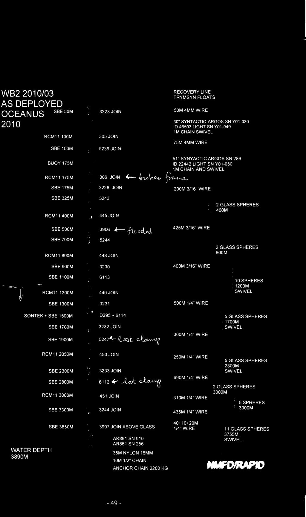
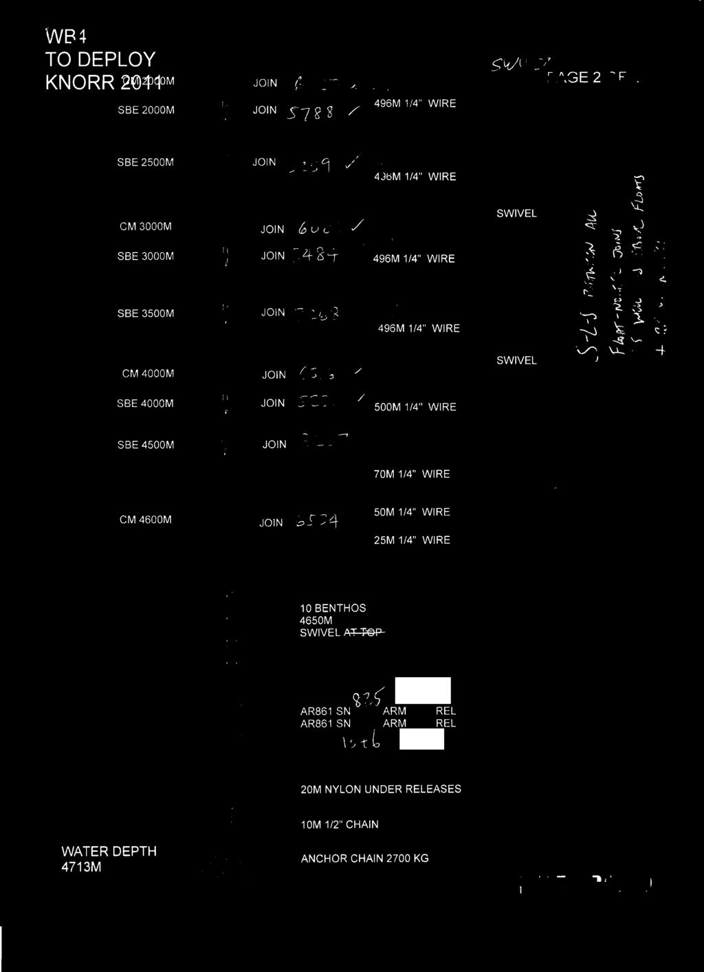
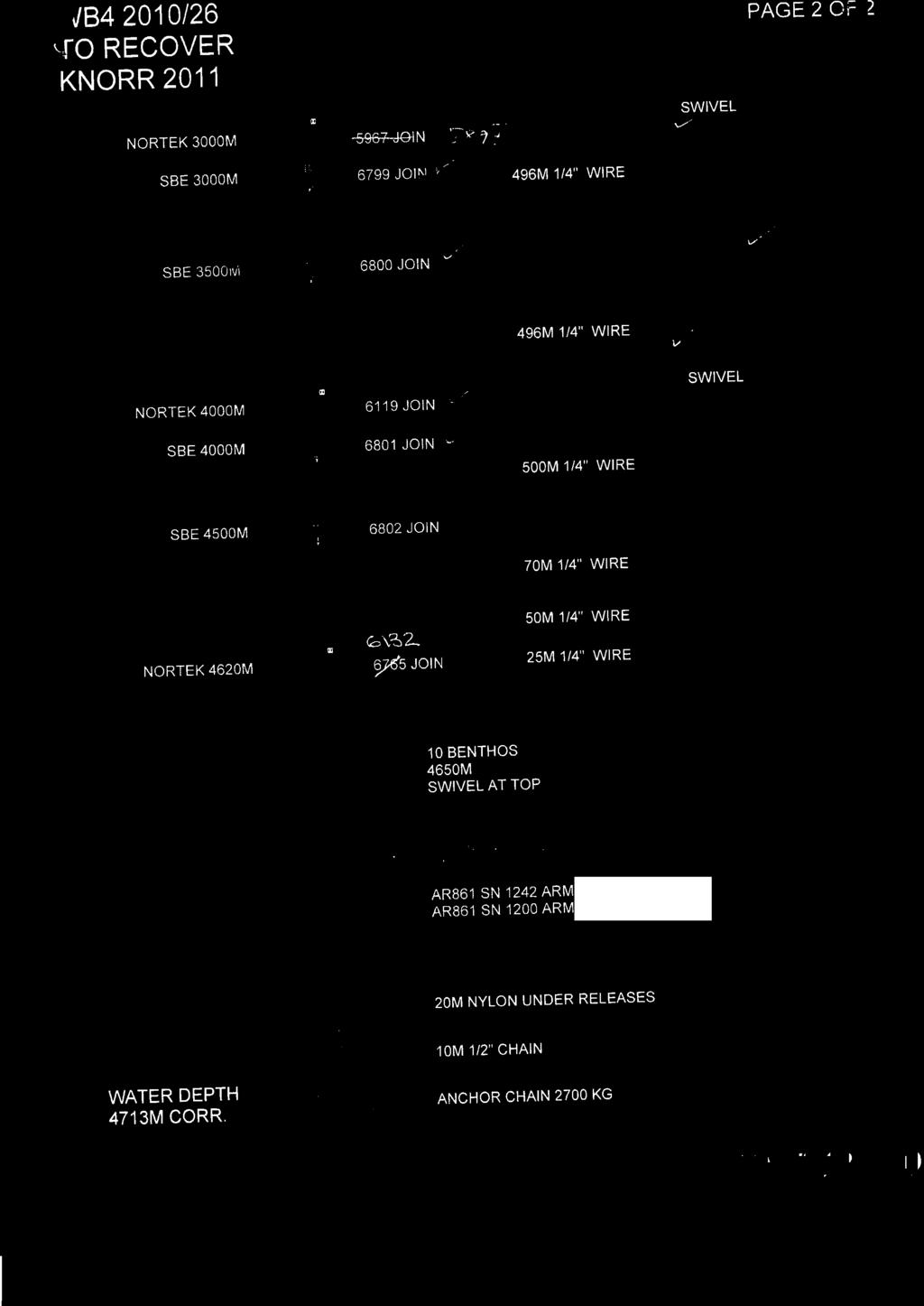
13 5.2 Array Specification The array as deployed in 2011 consists of a total of twenty- one moorings, twelve landers and two inverted echo sounders. Figures 5.2 and 5.3 are schematics showing each mooring and instrumentation in The eastern boundary moorings were serviced in the December- January cruise D359. Moorings are named in three sub- arrays. Western Boundary WB# with mooring number increasing to the east; Mid- Atlantic Ridge MAR#; Eastern Boundary EB#. The letter H is a historical reference to moorings originally intended to be HOMER profilers. Bottom landers instrumented with pressure recorders are indicated by L in the name. ADCP indicates an Acoustic Doppler Current Profiler mooring. Western Boundary Sub-Array At the western boundary, WB2 is the pivotal mooring and provides a full- depth density profile very close to the western boundary wall. As from April 2011, WB2 comprises seventeen CTDs and eight current meters, whereas WB1 comprises fifteen CTDs and four current meters. Inshore of WB1 there is WBADCP that comprises a Longranger ADCP at a depth of 600 m to measure the shallow Antilles current. East of WB2 is WBH2 consisting of three CTDs and five current meters. At the normal offshore extent of the Deep Western Boundary Current (DWBC) is WB4, which comprises fifteen CTDs and nine current meters. Further offshore is WB6, comprising five CTDs, one current meter and two bottom pressure recorders which combined with MAR0 measures the contribution to the MOC of deep water below 5200 m, including the Antarctic Bottom Water. There are six landers in this sub- array; two at the site of WB2; two at the site of WB4; and two at the site of WBADCP. Each lander comprises two BPRs. In addition to the moorings listed above, the western boundary sub- array also contains three full depth moorings and four landers from the University of Miami, which were serviced on this same cruise. WB0 comprises four CTDs, four current meters and an upward looking ADCP. WB3 is 22 km east of WB2 and so acts as a critical backup in case of loss of WB2. WB3 consists of seven CTDs and current meters. Combined with the other inshore moorings it provides the thermal- wind shear and measured velocities from the core of the DWBC. WB5 is located 500 km offshore and is instrumented with seventeen CTDs and provides the thermal- wind shear across the full width of the boundary currents including any recirculation. 13

14 Figure 5.2 Western boundary moorings as deployed on Kn
15 Figure 5.3 Array schematic after Kn200-4 cruise. 15
16 6 Diary of Events E. Frajka- Williams All times are local time unless specified. Sunday, 10 th April 2011 Eleanor, Darren and Chris travelled from Heathrow to Miami. Arrived in Miami at 17:30 local, drove to Ft. Lauderdale. (Moorings team arrived Friday.) Eleanor lost a filling in flight and had to find a dentist. Monday, 11 th April 2011 Loading and lab setup on the ship. We had some trouble getting to the ship as the berth had changed, but we were unaware. Additionally, access to the ship was only possible when escorted by someone carrying a TWIC card and a Ft. Lauderdale port pass (for $75/week) or a merchant marine card. Onboard, Darren and Chris set up the computers and network. The moorings team unloaded gear and set up the lab. After some negotiation, lab space was allocated. One container was delayed and deferred until tomorrow. Eleanor got a temporary filling, as well as some spare in case the filling falls out again mid- cruise. Tuesday, 12 th April 2011 Final containers arrive. One box of five microcats was not shipped from the NOC so Darren reallocates the mooring array with the 45 microcats onboard, expecting to redeploy 5 that we will recover. All science party moved onboard. Wednesday, 13 th April 2011 We sailed just after 08:30; Beautiful weather, partly cloudy and warm but breezy. We are aiming to reach Freeport, Bahamas by 15:30 to clear customs before they close for the day. Customs were cleared quickly and without issue. The first CTD was started before dinner, and the primary and secondary sensors match very well. Thursday, 14 th April 2011 The short CTD section was completed Wednesday evening, and caldips started this morning at 10:00. The weather continues to be good, with very calm seas and a slight breeze. Four caldips were planned for today (cast 6-9), with most of the microcats onboard scheduled for these dips. The dips are only to 3500 m (cast 8 to 4000 m) so the deepest instruments are being reserved for two final caldips at the end of the hydrographic section. The first caldip was completed after lunch, and the next begun. The first two dips had the new 150 khz LADCP package on it, which successfully returned data. Acoustic release tests were planned for the 3 rd and 4 th caldips. Shortly after the 3 rd caldip began, it was recalled that the pinger wasn t turned off, so the package was brought back to the deck after 1000 m and the pinger removed. The CTD frame with microcats and releases was turned around and cast 8 restarted around 20:00. Casts 8 and 9 had UK microcats and releases only, and were done overnight. Friday, 15 th April 2011 Caldips 8 and 9 were completed overnight. One microcat was not turned on (or the date set incorrectly) and so will be re- dipped later. Microcat 3229 had a bad conductivity 16
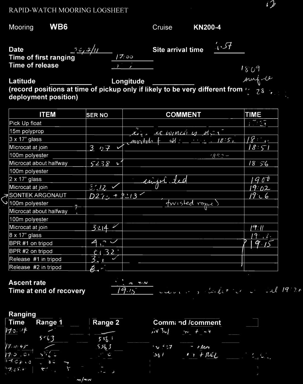
17 cell, but it had recently been returned from Seabird, so appears not to have been fixed. Today the moorings team is doing some wire winding, and RCM servicing. The hydrographic section began. Moorings are scheduled to begin with WB6 on Thursday, 21 st April. Saturday, 16 th April 2011 The hydrographic section and wire winding continue. In the evening, one cast had to be cut short (bottle stops skipped above 1000 m) due to the sighting of 3 flares. As the nearest ship, we were the first responders. It turned out to be a fishing vessel that had run out of fuel, so the Knorr acted as relay until a coast guard could respond, and then returned to the hydrographic section. Sunday, 17 th April 2011 The hydrographic section continues. Servicing RCMs. Monday, 18 th April 2011 The hydrographic section continues. Wire winding, building glass. Tuesday, 19 th April 2011 The hydrographic section continues. Weather is still good, but the forecast has heavy winds kicking in Wednesday afternoon (20 knots) and possibly higher on Thursday, with a low pressure region moving in from the east. Additionally, there appears to be a high pressure area with 35 knot winds to the northeast which will likely create swell for us. Wednesday, 20 th April 2011 Weather picked up this morning, so there was more activity tying things down in the lab. Hydrographic section continues, but is expected to end around midnight. Afternoon revision: Forecast was updated for some very bad weather (>30 knot winds) over the weekend, so we ve dropped the last two hydrographic stations and released WB6 at 17:07 GMT (13:07 local) this afternoon. We ll continue with tomorrow s schedule today, hopefully finishing the second caldip (cast 37) in the wee hours of Thursday morning. Thursday we ll be at WB5 and possibly compress the two day recover- deploy from Friday- Saturday into all day Thursday, and continue west, away from the weather. WB6 was successfully recovered. We used the ship s landtec winch to pull in the recovery line, and then switched to a block on the crane, which was also secured using two handlines to cleats. Recovery took 2.5 hours from time of first ranging to deck secure. The 5 th caldip was set up (CTD cast 36) with pre- cal microcats for WB6 replacement, and some additional deep microcats for WB4. The weather system is now being monitored as invest 91L. WB6 was deployed, with a conservative setup distance of 0.5 nm at 01:37 GMT (21:37 local). We dropped the anchor at 01:56 GMT about 200 m off the target. Thursday, 21 st April
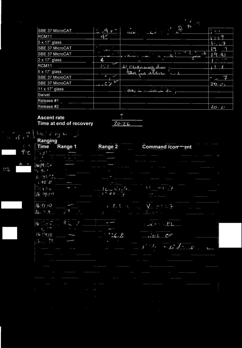
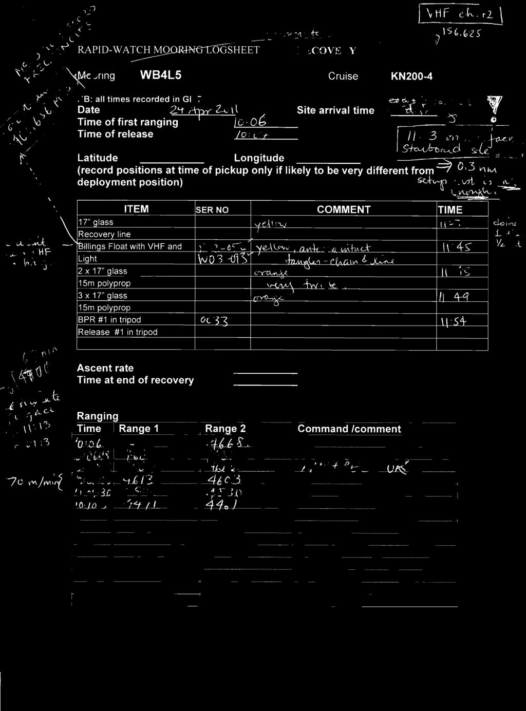
18 We arrived at site E (WB5) around 10:00, and started mooring recovery just after lunch. The mooring was successfully recovered, followed by the lander surfacing after dinner. After cleaning the deck, the replacement lander was deployed. It was a late night. PIES telemetry continued until the early hours of the morning. Friday, 22 nd April 2011 WB5 replacement was deployed after breakfast, starting around 09:30, with triangulation finishing around 3pm. We left for WB4. The lander frame for WB4L was built in the afternoon, and winch and reeler set up for WB4 recovery tomorrow. Saturday, 23 rd April 2011 We arrive at WB4 site at 10:30, check winds and currents then move off by 0.5 nm to release it. Discussed with the bridge that we d go to the site, and check the currents and wind speed, then move off by 0.5 nm for the release. We released the mooring around 11:15 local, then started pickup shortly after. However, due to the way the mooring was laying, we steamed for 50+ min before hauling. There was also some nearby traffic that was not responding to the bridge when they called. Mooring recovery was completed at 16:30 local, and the lander deployed before 18:00. A caldip of the WB5 microcats is scheduled for 20:00. The PIES deployment was delayed until tomorrow. Sunday, 24 th April 2011: Easter Sunday We fired WB4L5 at 06:00 local, with a setup distance of 0.3 nm away. The lander surfaced at 07:13 local, behind us off the starboard side. After some maneuvering, it was all onboard at 07:55 local. After breakfast (08:15-11:30 local) we built the 8 strings of 5 rugby ball floats. It took over 3 hours for 5-7 people working continuously (except for a short tea break) to assemble them all. After lunch, preparation continues for WB4, with moving anchors and syntactic foam floats. Mooring deployment started with the first float in the water at 12:55 local. We were running against a current of kts, so in the first 1 hr 10 min and 1200 m out, we only made 0.4 nm overground. After 3 hours of towing, the mooring was deployed at 18:30, followed by a triangulation of both WB4 and WB4L. It was discovered that the lander had moved more from its anchor drop than WB4 (0.23 nm for the lander, vs 0.17 nm for the tall mooring), suggesting that it is necessary to triangulate its position every time. CTD cast 39 proceeded overnight to caldip the microcats from WB4 recovery. Monday, 25 th April 2011 The RSMAS group recovered WB3 then WB3L, then redeployed WB3L. The weather has turned wet, with gray clouds everywhere, and raincoats for all the people working on deck. Overnight, PIES C was deployed, and a calibration cast done for the PIES. Tuesday, 26 th April 2011 Mooring deployment of WB3L started after breakfast. Weather is brighter today than yesterday, and dry, but not as sunny as it has been. After checking the sites for past deployments of WBH2, WB2 and WB1, sites were chosen for their redeployment. In particular, the site used for WBH2 on the Oceanus 459 spring 2010 cruise was some distance away from the target site, since the mooring was deployed before it was recovered. We will be using the previous deployment site (from RB0901) for WBH2, which is N, W. The site chosen for WB2 is in the middle of the past WB2 sites, at N, W. For WB1 it is N, W. Fallback for 18
19 WBH2 was 0.42 nm on RB0901 and 0.47 nm on OC459. Fallback for WB2 was 0.35 nm on RB0901 and 0.24 nm on OC459. Fallback for WB1 was 0.11 nm on RB0901 and 0.06 nm on OC459. In these cases, we ll pass the deployment site by 800 m (0.43 nm) for WBH2, 500 m (0.27 nm) for WB2 and 150 m (0.08 nm) for WB1. WB3 deployment finished at 12:45. Watching to the bottom, then on to WBH2. Wednesday, 27 th April 2011 We deployed WBH2 after breakfast. Everything went quickly and smoothly. The usual setup distance of 2.5 nm was doubled to 5 nm because we were running with a 0.8 kt current. However, Rob asked for the ship to do 1.8 kt through water, which resulted in a fast time over ground. The mooring anchor was released shortly after 10:30. We planned to survey, but after watching it down, decided to move on to recover WB2 instead. We couldn t hear the releases at first, but it turned out it was because of the strong surface current, which was causing the transducer to lay out alongside the ship rather than hang down. We asked the bridge to drift, and were able to sound and release the mooring. It was on the surface before we had a confirmed ascent rate. Approach took slightly longer than expected, possibly due to a less experienced driver. However the approach was calm and controlled, which is better than haphazard or rushed. During the approach, a sport- fishing vessel was sited off the starboard bow, heading towards the mooring in the water. The deck officers were finally able to raise it on the radio, and ask them to turn away. Recover from then on was smooth, though several instruments had problems. It appeared as though WB2 was subject to vibration or strumming. One RCM11 had broken bolts. Two microcats had lost their guards, and one microcat was flooded (the last not expected to be related to strumming). We then triangulated WBH2 and found that it had not fallen back, but instead drifted south likely with the deep currents by 0.22 nm from the anchor drop position. The result was that WBH2 is now deployed in deeper water than intended, by about 60 m. We will attempt to allow for an unexpected anchor drift tomorrow, with WB2 s deployment. Thursday, 28 th April 2011 We began with deploying WB2. We chose to deploy it upcurrent, downwind, with a 2 nm setup distance. This was assuming a current speed of 1 kt, 1.5 kts through water and 4 hours to work. However, the current was up to 1.5 kts for part of the time, meaning that after the first hour, we d only made 0.3 nm over ground. Deployment began around 09:00, and ended around 14:00. Even so, the lander WB2L5 was recovered, and WB2L7 deployed before dinner. Triangulation showed that WB2 had only moved 0.17 nm from the anchor drop point, and so was well within the desired target area. In the evening, the microcats from WB2 were caldipped. Friday, 29 th April 2011 The day began with WB0 release after breakfast, and quickly finished around 09:00. WB1 was released just before 10:00, and after a quick approach and grapple, was all onboard by 11:40. It was decided to redeploy WB1 in the afternoon, rather than wait till the following day, and deployment started around 13:00. We had surface currents of nearly 2 kts, so after discussions with the bridge, it was decided to start slightly 19
20 upcurrent of the anchor dropsite (by about 0.2 nm) and by steaming upcurrent at 1.5 kts, end up sliding backwards to the drop site. This was quite effective, though relative to other drop positions, the stern of the ship was further along the track than when we are moving ahead over ground. After surveying the anchor position of WB1, we recovered WBADCP. There was some debate about whether to recover tonight or tomorrow, due to a rainsquall that was about 5 nm off the recovery site. After watching the radar for a few minutes, it was determined that the squall was not moving, and there were 10 kts of wind holding it back. We released the mooring at 17:48, and soon after, lightening and thunder were seen in the squall. The squall moved forward and there was heavy rain on the ship by 18:06, as well as lightening that was a bit close for comfort. All instruments were onboard at 18:10, and people under cover a minute or two later. Pies telemetry continues tonight. Saturday, 30 th April 2011 After breakfast, the US team deployed their WB0, then surveyed until shortly after 11:00. We steamed to the site of WBADCP and deployed after lunch. The lander was deployed shortly after, and moorings work concluded by 14:00. The last caldip began around 16:00 with instruments from WB1. Following the caldip, an ADCP survey of the Antilles current was executed. 20
21 7 Mooring Operations R. McLachan 7.1 Mooring Summary Tables 7.1 and 7.2 summarise the mooring operations on KN Mooring name NMFD mooring number Deployment cruise Deployment date/time Recovery date/time WB6_4 2010/01 OC /03/ :45 20/04/ :03 WBH2_4 2010/04 OC /04/ :42 26/04/ :05 WB2_8 2010/03 OC /03/ :20 27/04/ :30 WB1_7 2010/08 OC /04/ :18 29/04/ :30 WBADCP_7 2010/06 OC /04/ :05 29/04/ :30 WB2L5_5 2009/10 RB /04/ :00 28/04/ :30 WB4L5_5 2009/11 RB /04/ :39 04/05/ :00 Table 7.1 Summary of UK mooring recoveries on KN Mooring name NMFD mooring number Latitude N Longitude E Depth (m) Deployment date/time Wb6_5 2011/ /04/ :56 Wbh2_5 2011/ /04/ :36 WB2_9 2011/ * 28/04/ :21 WB1_8 2011/ /04/ :01 WBADCP_8 2011/ /04/ :32 WB2L7_7 2011/ * 28/04/ :19 WB4L7_7 2011/ /04/ :56 WBAL2_2 2011/ /04/ :21 Table 7.2 Summary of UK mooring deployments on KN * echo sounder not on. + not recorded. 7.2 Diary of Events 13 th April Mobilisation complete, set sail at 09: th April Wound on moorings WB4 and WBH2. Eight releases were got ready for dip cast. Four casts will be carried out for Seabird calibration, four releases on each of the last two, down to 4000 m and 3500 m respectively. The four releases that went down to 4000 m all worked well, good communication. Four releases down to 3500 m all worked fine with good communication. 15 th April Wound on mooring WB2. Downloaded Seabird calibration data. Prepared instruments. 16 th April Wound on WB11. Got ready WB6 ropes. Assembled WB6 buoyancy packages. Doubled up all of the releases that have been tested. 21
22 17 th April Assembled Nortek frames. Assembled buoyancy packages for WB4L7 and WHB2. 18 th April Started working on RCM11s, new DSUs checked, time updated and erased. Installed in to the RCM11s. 19 th April Installed batteries in to Nortek. Updated mooring diagrams. 20 th April Installed new batteries and tested all Novatech lights and Argos beacons. Due to the weather it has been decided to cancel the last two CTD casts in order to get mooring recoveries underway, to this end we steamed to WB6 site and started communication with the releases, both releases responded well and serial number 361 was used to release the mooring, the accent rate was calculated as 92 m/min. Whilst this was on its way up we readied four more releases and 8 Seabirds 37s for cal/test dip. Two BPRs were also prepared for deployment. An Argos beacon; sn Z02-003, ID and light sn Z were also got ready for deployment on WB6. WB6 was recovered without problems, though the two glass spheres at 5300 m had imploded. The 4 releases and 8 Seabirds were then secured to the CTD frame and the CTD was subsequently deployed. The releases all responded well to communication, once the echo sounder was turned off. Six more releases were bench tested and all worked fine, ready for the next CTD deployment. Two of the releases from the four that were last tested were used on WB6, serial numbers 498 and 324. The releases were assembled in to the tripod and the mooring was then deployed, there was hardly any light on deck, combined with the ship movement due to weather and the limited deck space, this operation was far from ideal. The deployment also took place at 20:45 in the evening. 21 st April All of the 6 releases communicated well, upon recovery all had fired. These were then assembled in to doublers ready for deployment. Deck being prepared for Miami WB5 mooring recovery. WB5 recovered with a few tangles to contend with but otherwise ok. WB5 Lander was then recovered without problem. We then got a replacement Lander ready and deployed that. 22 nd April Deployment of Miami WB5 mooring. 23 rd April 22
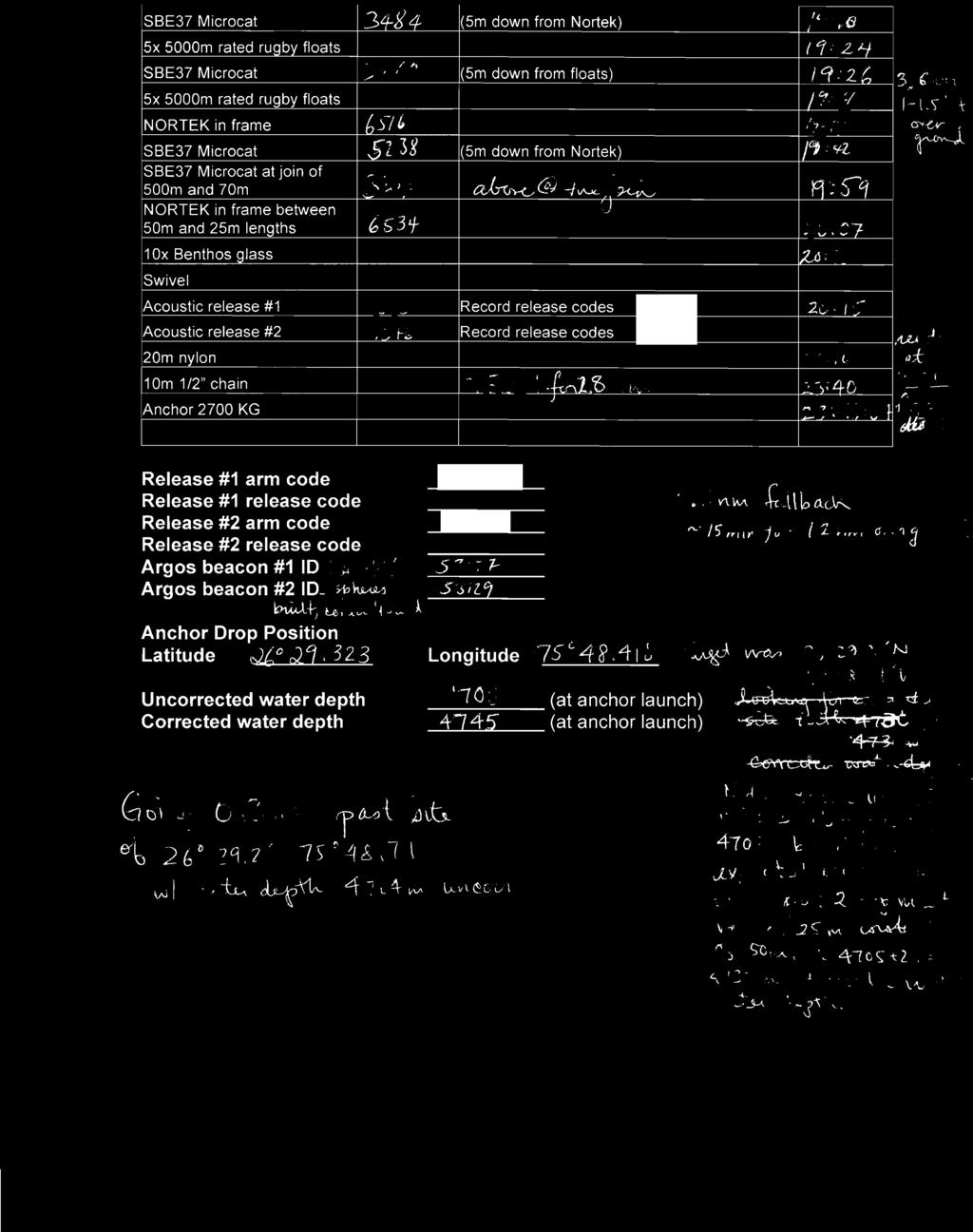
23 We started by readying the deck for the recovery of WB4, recovery was delayed whist the ship manoeuvred. Recovery was completed without incident. Fish bite was noticed; see photos. We then deployed WB4L7 and moved the recovered rugby floats up to the next deck. 24 th April Steve and Dave up at 05:30 to fire the release of WB4L5, the rest of us up at 06:15, the Lander was then recovered. We then got things ready for the WB4 deployment, this took quite a while as we had to build the rugby floats and these are difficult to assemble. We are now towing the mooring to the deployment site. Mooring anchor released and the mooring was watched to the sea bed, 190 m/min decent rate. We then triangulated both WB4 and WB4L7 at the same time as both are near each other. We did this by entering the arm code of both releases at the same time, one into the arm command box and one into the command box, this worked well. 25 th April Tom and Colin up at 06:30 for winch driving for the Miami moorings although the mooring was not released until 07:20. WB3 was then recovered followed by the Lander recovery then a replacement Lander was deployed. All of the Seabird 37s for WBH2 and WB2 had a complete service, see spreadsheet for details. The Seabird spares boxes were then replenished. Updated mooring diagrams. 26 th April Started deployment of WB3 at 08:00. Arranged labs ready for WBH2 and WB2 recovery. Set up Norteks for WBH2 and WB2. WB3 deployed, releases watched to bottom, we then steamed to WBH2 site and started communication with the releases, both releases responded well and gave good ranges, serial number 911 was used to release and an accent rate of 80 m/min was recorded. The recovery line was tangled with the 1500 m current meter; a couple more small tangles presented themselves both nothing major. We then started to break down the recovered glass and re- assemble into buoyancy packages for WB2. We also removed the recovered ropes from the winch and put the drum with WBH2 to deploy in its place. 27 th April Finished preparation for WBH2 deployment, deployment then commenced and all went well, the releases were watched to the bottom. We then prepared for WB2 recovery. At first we had difficulty establishing communication but the Superducer was trailing fwd. Once this was sorted out the releases both worked fine. The mooring was then recovered with a few tangles to deal with. We then dismantled the recovered glass and then finished off assembling the glass for WB2 to deploy. We then triangulated WBH2 that was deployed earlier. 28 th April WB2 lower buoy Argos and light will use the recovered ones from the same mooring. Argos for the upper buoy y , light x
24 Started at 07:00. Got everything ready for the WB2 deployment, deployment went well, though we had to tow for a while before dropping the anchor. We then watched the releases to the bottom. We then set up for the recovery of WB2L5, the releases responded well and the mooring was released, recovery commenced. We then prepared for WB2L7 deployment, this went well. We then steamed to the first triangulation point for both WB2 and WB2L. Triangulation of both moorings was then undertaken. After this we assembled all of the buoyancy ready for the WB1 deployment. The CTD frame was then loaded with seabirds ready for the calibration dip. WB1 to deploy will use Argos sn z id and light sn x on the small buoy. 29 th April Started with the recovery of WB0, this went well. We then repositioned and started the recovery of WB1, this also went well. We decided to do a quick turn around and redeploy WB1, so we did this and all went well, so well that we had time to recover the ADCP west mooring. There was some confusion on the bridge and we ended up steaming off while the chain and release was still in the water, all was recovered in the end with no harm done. 30 th April The day started with the deployment of WB0, this went well. We then repositioned while we got the ADCP west ready for deployment. This was subsequently deployed without incident. We then repositioned ready for the WBAL2 deployment whilst getting it ready. The Lander was then deployed without incident. There will be one final Seabird calibration dip. End of mooring operation. 24
25 8 Instruments 8.1 Summary of Instruments Recovered and Deployed Table 8.1 gives a summary of the instruments recovered and deployed on cruise KN Appendix B gives more detailed information on which instruments were recovered from each mooring along with a summary of the length of record obtained. Complete setup details of deployed instruments can be found in Appendix C. Instrument type CTD Single Point Current Meter Current Profiler Manufacturer and model Seabird SBE37 SMP MicroCAT Seabird SBE37 IMP MicroCAT Sontek Argonaut MD Aanderaa RCM11 Nortek Aquadopp RD Instruments 75 khz Longranger ADCP Total intended for recovery 54 Total recovered Total lost 0 54 (2 flooded) BPR Seabird SBE53 BPR Total deployed Table 8.1 Summary of instruments recovered and deployed 8.2 Instrument Problems D. Rayner Seabird MicroCATs Sn:3229 had a slow conductivity response on the caldip, most likely caused by a faulty pump. This was exactly as seen on OC459 and this instrument had been back to Seabird but obviously wasn't fixed. I think this is because Seabird were not told of the specific problem so performed a standard calibration and service (the Seabird calibrations switch the pump off so the fault was not noticed). Sn:5246 was under reading pressure by approximately 100 dbar on the pre- deployment caldip so was not deployed. Sn:6819 was over- reading the pressure on the post- deployment caldip. This was as expected as it was seen to over- read on the pre- deployment caldip aboard cruise RB1009, but the fault was not noticed until after the instrument had been deployed. Sn:6112 needs a new bulkhead connector. The thread is broken due to a likely impact with the guide clamp, which we suspect came off when the mooring was subject to strumming. Sn:3906 flooded on WB2 at approximately 500 m. This instrument has had a Kistler pressure sensor fitted and went on a pre- deployment caldip on the Oceanus. Strumming 25
26 had caused the guide clamp to shake loose and the pins were bent - probably from the impact of the guide, but the cause of flood is unknown. Sn:3930 flooded on WB1 at approximately 500 m. It was recovered with the end cap blown off but the reason for the flooding is unknown. It too has recently been changed to a Kistler pressure sensor. Sn:3231 had a bad T response on the post- deployment caldip and needs to be recalibrated. Sn:6118 has a poor conductivity response on the post- deployment caldip and therefore a suspect pump. Nortek Aquadopps Sn:5897 had the pressure sensor under- reading on WB4. This was excepted as it was not zeroed before deployment on RB1009 despite being noticed to be under- reading previously. There were however four other Norteks that were not zeroed prior to deployment and therefore are also under- reading pressure. The pressure sensor under- reads by a fixed amount and so offsets of 1575 dbar, 1170 dbar, 1135 dbar and 1090 dbar need to be applied to correct the data for instruments with serial numbers 5897 (from WB4), 6743, 6751 and 6753 (all three from WBH2) respectively. Sn:5963 cannot be corrected as it was deployed at approximately 100 m depth and the offset was evidently greater than this as the record does not deviate from zero for the duration of the deployment. The setup procedures will be modified to ensure that the pressure sensor is zeroed when the instrument is readied for deployment. Nortek 5963 has a broken pin in the connector. The cap was fouled with a hard calcareous growth which when twisting off the end cap sleeve caused the pin to break. It was downloaded with an end cap from another instrument instead, but this needs fixing. Sontek Argonaut MDs There were problems when downloading the Sontek from WB2 (sn D295). At first the instrument would not connect at any baud rate. It eventually connected at 600 baud and I sent the command userdefaultbaudrate set The instrument replied with an ok acknowledgement so I changed the software to to match. The instrument would not connect at this higher baud rate. After much playing around (including using an external power supply instead of the battery) I eventually found that it could hear commands but not reply properly so I reduced the baud rate till communications were reliable. The highest baud rate that could get it to talk "cleanly" was at 2400 but this was still causing problems. If using the recorder button in SonTerm (part of Sonutils) then it would say there was a problem with the recorder and to check that it was installed correctly. This didn't work at any baud. However when trying the ViewArgonaut recorder function at 2400 the recorder showed two files. The main deployment file (WB2001) being bytes and a second file (WB2002) being 1330 bytes. These files were then at The download took place on Paul's old laptop using SontekRecorder v2.61. Aanderaa RCM11s 26
27 Sn:450 frequently didn't record the 8th channel (and sometimes the 7th channel too). The records therefore ended up joined together and had to be manually split during the download process and the missing channel data filled with This may cause spikes in the signal strength record. 27
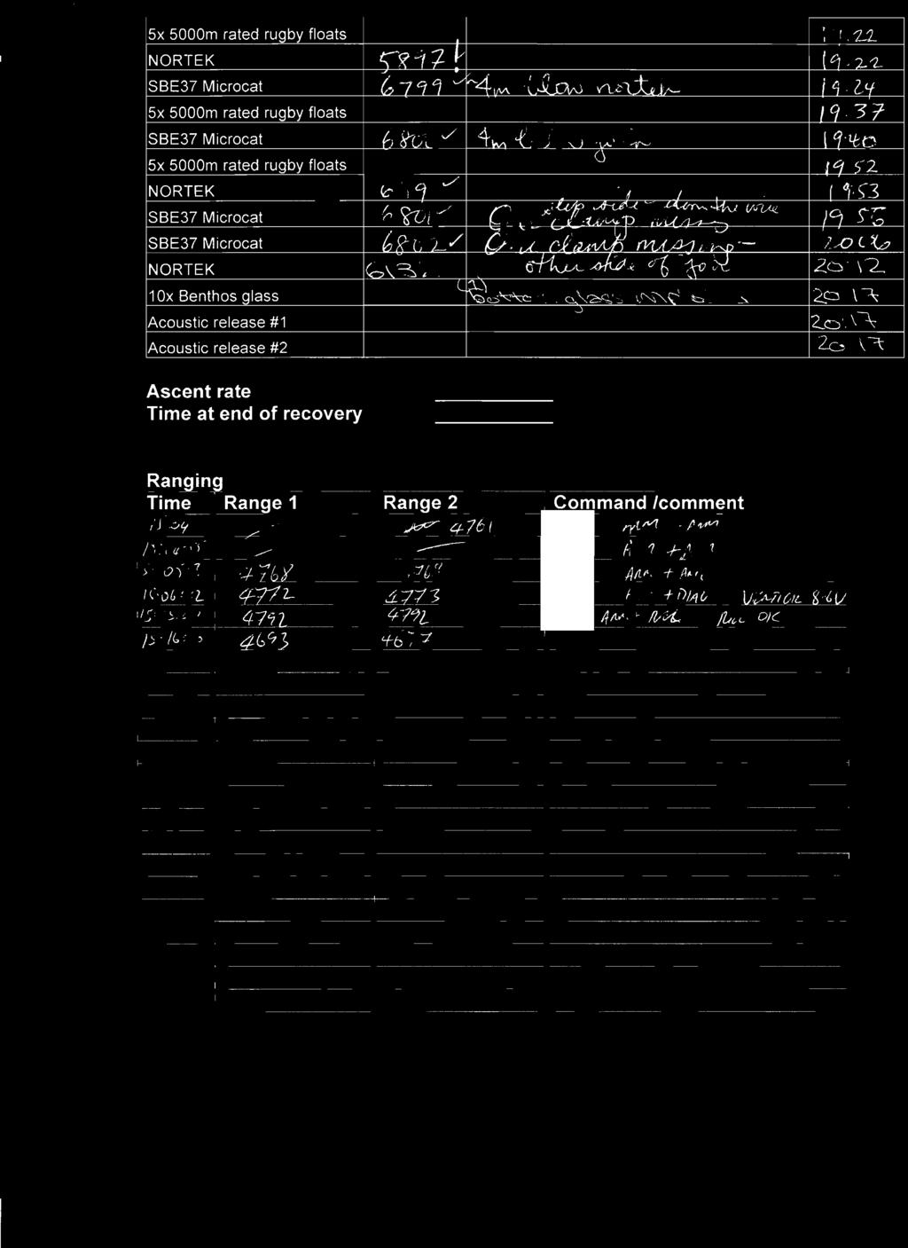
28 9 Mooring Instrument Processing 9.1 SBE 37 MicroCAT Processing E. Frajka- Williams The standard processing scripts were used for this cruise, based on those used for D359. Raw data and capture files for calibration casts (caldips) are located on hydrosea5 mac mini, in directory raw/kn200-4/microcat_cal_dip/ (relative to /Users/hydrosea5/kn200-4/rpdmoc/rapid/data/moor/) and for moorings, in directory raw/kn200-4/microcat/. Stage 1 caldip data is in proc_calib/kn200_4/cal_dip/microcat/cast[cast number]/ along with the info.dat file. Stage 1 and later processing stages for moorings are located in proc_kn200_4/[mooring name]/. Stage 0 Download The MicroCAT data were downloaded with Seabird SBE Seaterm software (for SMPs with firmware<3.0d), with Seabird SBE SeatermV2 software (for SMPs with firmware>=3.0d) and with Darren s IMPDownload routine (for IMPs). For instruments recovered from moorings, the standard filenames were XXXX_data.asc (or.cnv and.xml for the version 3.0 firmware microcats) and XXXX_recover.cap where XXXX is the serial number. For instruments recovered from caldips, it was XXXX_cal_dip_data.asc and caldip_xxxx.cap for calibration dip files. Stage 1 Conversion from.asc to the RDB format.raw The file used for processing mooring data was mc_call_2_kn200.m (copied from mc_call_2_d359.m ), and that for processing calibration dips was mc_call_caldip_kn200.m (copied from mc_call_caldip_d359.m ). For calibration dips, a function called parse_cnv.m was created to process the SBE911 CTD data in.cnv format to.mat format with appropriate filenames, and CTD data were located in /Users/hydrosea5/kn200-4/ctd/. This function is located in directory exec/kn200_4/calibration/. Stage 2 Trimming of Data Record The script used was microcat_raw2use_003.m with no cruise name appended. The script is modified with the addition of mooring names, data directories, and plot interval, but the start and end dates used are read in from the info.dat files. CTD Calibration Casts To estimate any trend in conductivity, temperature and pressure reported by the SBE37 MicroCATs during their year-long deployment (for example due to biofouling or sensor drift), each instrument is lowered on the CTD package to provide pre or post deployment 28
29 calibrations. Up to 24 SBE37 CTDs are clamped to straps on the CTD frame and secured by plastic cable ties. The sampling rate is set to a period of 10 s, which is the fastest available. For pre deployment instruments the sample number is set to zero, for post deployment instruments the sample number is one more than the last sample number from the year-long deployment. The lowered CTD is a Seabird 9/11 with recently calibrated CTP sensors with the C being adjusted to absolute values of conductivity by reference to seawater samples drawn and analysed against standard sea water. The CTD is lowered to a minimum depth of 3500 m into where the ocean temperature and salinity distribution is stable. The maximum depth of the cast is then chosen to be the depth at which the deepest MicroCAT was deployed on a mooring. This maximum depth requirement is important for providing accurate pressure calibrations, but is not critical for temperature or conductivity. During the upcast the CTD is stopped for five minute bottle stops at several depths, providing stable comparisons between CTD and MicroCATs. CTD bottle samples are also obtained at these depths. On this cruise there were 12 Niskin bottles, so 12 five minute comparisons between CTD and MicroCAT are available. On recovery, MicroCATs are downloaded in the usual way. Microcat data are then processed together using mc_call_caldip_kn200.m. This now reads a CTD 1 hz file in.cnv format which was provided by the NOAA group, Rigoberto. Particularly for pre-deployment instruments, comparisons between the CTD and MicroCATs at bottle stops are inspected for anomalies in the MicroCAT records. Examples are lagged conductivities due to pump problems or bad pressures. These instruments are withheld from deployment. More serious calibration work to adjust mooring MicroCAT data is a post cruise activity 9.2 Current Meter Processing D. Rayner Current meter data were simply processed with the available scripts. Stage 0 is downloading the data from the instruments, converting it to a Matlab- readable format, and transferring it to the computer system. Files for Anderaa RCM11 current meters are found in rcm/ or rcm11/ directories; those for Nortek Aquadopp current meters are found in nor/ or nortek/; those for Sontek Argonaut current meters are found in argonaut/ or arg/ or argocat/. The files used are listed below for each stage with any noteworthy comments. RCM11 Stage 1 Stage 2 Nortek Stage 1 Stage 2 Sontek Stage 1 Stage 2 rcm2rodb_05.m This script requires a version of Matlab with the brush function to correct conductivity wrapping. rcm11raw2use.m nortek2rodb_01.m nortek_raw2use_01.m argocat2rodb_004.m. Has been updated to fix a bug where the data format changed slightly for files produced in ViewArgonaut version New format has 2 fewer columns in it (CellBegin and CellEnd are missing). argocat_raw2use_003.m 29
30 The Longranger ADCP data were downloaded from the instrument into a binary format using RDI software. The data are then passed on to our American colleagues for post processing. 9.3 Seabird SBE26 or SBE53 BPR Processing E. Frajka- Williams The standard processing scripts were used for this cruise, based on those used for D359. Raw data and capture files are located on hydrosea5 in directory raw/kn200-4/seagauge/ (relative to /Users/hydrosea5/kn200-4/rpdmoc/rapid/data/moor/) while later processing stages are located in proc/[mooring_name]/. Stage 0 Data are downloaded with Seabird SBE Seaterm and transferred to the processing computer, and any comments are recorded in written logs. Stage 1 This step is performed with seagauge2rdb_003.m, which is essentially unmodified from previous cruises. No clock offsets were needed, hence the file raw/kn200-4/clock_offset.dat does not exist. These offsets typically come from incorrect dates entered during initial setup or while downloading from the instrument, rather than clock drift (see stage 2). Stage 2 The filename seagauge_raw2use_kn200.m was used, which was originally called seagauge_processing_002.m a few cruises ago. Clock offsets at the end for the cast are treated as linear drifts and are recorded in raw/kn200-4/seagauge/bpr_clock_offset.dat. 30
31 Appendix A Details of Instruments Lowered on CTD Calibration Casts Pressure offsets greater than 15 dbar during a calibration cast are noted. Timing off indicates that the microcat clock does not match the CTD clock. Cruise Cast Number Team s/n Notes US 3164 US 3166 US 3168 US 3861 US 3865 US 4624 US 5871 US 5872 US 5873 US US 5875 US 3868 Timing off UK 3483 UK 3486 UK 4714 Timing off UK 3248 UK 3249 UK 3251 UK 3252 UK 3253 UK 3257 UK 3216 Large pressure offset 7 US 3150 US 3154 US 3155 US 3162 US 3866 US 3867 US 3869 US 3870 US 3871 US 3872 US 4619 US 4621 US 5878 US 5881 UK 3259 UK 3264 UK 3268 UK
32 UK 3900 UK 3901 UK 3903 UK 4066 UK 5242 Large pressure offset UK 5765 Large pressure offset UK 6839 Large pressure offset UK 3229 Slow conductivity response UK 3284 UK 3484 UK 5788 UK 3904 UK 3910 Timing off UK 4461 UK 3916 UK 4464 Timing off UK 6823 UK 7681 UK 6841 UK 6838 UK 6837 UK 6834 UK 6833 UK 6832 UK 6831 Large pressure offset UK 6829 UK 6817 UK 6818 UK 3247 UK 5246 Large pressure offset dbar UK 6820 UK 6821 UK 6822 UK 3209 UK 6816 Large pressure offset UK 6840 UK 3207 Large pressure offset UK 5238 UK 3212 UK 3213 Large pressure offset UK 3214 UK 3206 UK 3215 UK 6819 Large pressure offset dbar UK 3219 UK 3221 UK 6798 UK 6799 Slow conductivity response UK 6800 UK
33 UK 6802 UK 3222 UK 3234 UK 3224 UK 3913 UK 3225 Table A.1 Details of instruments lowered on CTD calibration casts. 33
34 Appendix B Instrument Record Lengths Mooring name Type s/n WB6 Date of first useable record [YYYY MM DD HH] Date of last useable record [YYYY MM DD HH] Approx depth SBE SBE SBE Sontek D :00: :30:00 SBE SBE BPR BPR SBE Nortek SBE SBE Nortek SBE SBE Nortek SBE SBE Nortek WB4 SBE Nortek SBE Nortek 5897 $ SBE SBE Nortek SBE SBE Nortek SBE SBE Nortek WB4L BPR Nortek Nortek 6743 % Nortek WBH2 Nortek SBE SBE Nortek SBE WB2 SBE :30: :30:01 RCM
35 WB2L WB1 WBADCP SBE :30: :30:02 RCM SBE :30: :30:00 SBE :30: :30:02 RCM SBE Bent end cap - flooded SBE :30: :30:02 RCM SBE :30: :30:01 SBE :30: :30:01 RCM SBE :30: :30:02 SBE :30: :30:01 Sontek D :30: :30:00 SBE :30: :30:00 SBE :30: :30:03 RCM SBE SBE RCM SBE :30: :30:02 SBE :30: :30:01 BPR :00: :30:00 BPR :00: :30:00 SBE :30: :30:02 Nortek 5963* SBE :30: :30:01 SBE :30: :00:02 SBE :30: :30:01 SBE :30: :30:02 RCM SBE :30: :30:01 SBE Missing end cap - flooded SBE :30: :30:01 SBE :30: :30:02 RCM SBE SBE SBE SBE RCM SBE :30: :30:01 SBE :30: :30:01 75 khz ADCP Table B.1 Record of the instrument record lengths recovered during KN (* indicates no valid pressure data. $ indicates pressure offset of approx 1575 dbar. % indicates pressure offset of approx 1170 dbar. indicated pressure offset of approx 1135 indicates pressure offset of approx 1090 dbar.) 35
36 Appendix C Instrument Setup Details WBADCP RDI Longranger 75 khz Workhorse ADCP s/n: System frequency: 76.8 khz Beam angle: 20 degrees Water salinity: 35 Depth of transducer: 600 m Heading alignment: 0 Heading bias: 0 Depth cell size: 1600 cm Number of depth cells: 40 Blank after transmit: 0704 Pings per ensemble: Ambiguity velocity: 175 cm/s radial Time per ensemble: 00:30:00 Start date: 30/4/11 15:00 WBAL2 SBE53 BPR s/n, Start time: 0039, 30/4/11 14: , 30/4/11 14:00 Header: wbal2_deployed2011_kn200-4 Tide interval: 30 min Tide measurements duration: 30 min Frequency of reference Every 96 samples measurement: Nominal depth: 500 m WB1 SBE37 MicroCAT SMP CTD s/n (nominal depth), Start time: 3284 (50 m), 29/4/11 17: (105 m), 29/4/11 17: (175 m), 29/4/11 17: (255 m), 29/4/11 17: (325 m), 29/4/11 17: (405 m), 29/4/11 17: (500 m), 29/4/11 18: (600 m), 29/4/11 18: (700 m), 29/4/11 17: (805 m), 29/4/11 17: (900 m), 29/4/11 17: (1000 m), 29/4/11 17: (1100 m), 29/4/11 17: (1205 m), 29/4/11 17: (1350 m), 29/4/11 17:00 36
37 Sample interval: 1800 s Nortek Aquadopp CM s/n (nominal depth), Start time: Deployment name: Sampling interval: Averaging interval: Blanking distance: Compass update rate: Speed of sound: Salinity: 35.0 Diagnostic interval: 720 min No. diagnostic samples: (100 m), 26/4/11 22: (400 m), 26/4/11 22: (800 m), 29/4/11 14: (1200 m), 26/4/11 22: =wb1_a 5899=wb1_b 5831=wb1_c 6765=wb1_d 1800 s 30 s 1.5 m 10 s Fixed WB2 SBE37 MicroCAT SMP CTD SBE37 MicroCAT IMP CTD SBE37 MicroCAT IM CTD Nortek Aquadopp CM s/n (nominal depth), Start time: s/n (nominal depth), Start time: s/n (nominal depth), Start time: Sample interval for all CTDs: s/n (nominal depth), Start time: Deployment name: 3220 (50 m), 28/4/11 12: (105 m), 28/4/11 12: (180 m), 28/4/11 12: (325 m), 28/4/11 12: (500 m), 28/4/11 12: (700 m), 28/4/11 12: (1300 m), 28/4/11 12: (1500 m), 28/4/11 12: (1700 m), 28/4/11 12: (1900 m), 28/4/11 12: (2300 m), 28/4/11 12: (2800 m), 28/4/11 12: (3300 m), 28/4/11 12: (3850 m), 28/4/11 12: (900 m), 28/4/11 12: (1100 m), 28/4/11 12: (105 m), 28/4/11 12:00 (This is a RSMAS loan unit without a pump) 1800 s 9204 (100 m), 26/4/11 22: (175 m), 26/4/11 23: (400 m), 26/4/11 23: (1500 m), 26/4/11 23: =wb2_a 9210=wb2_b 37
38 9213=wb2_c 5893=wb2_d Sampling interval: 1800 s Averaging interval: 30 s Blanking distance: 1.5 m Compass update rate: 10 s Speed of sound: Fixed Salinity: 35.0 Diagnostic interval: 720 min No. diagnostic samples: 20 Aanderaa RCM11 CM s/n (nominal depth), Start time: Recording interval: No. of channels: 8 Mode: Burst Temperature range: NB: these were not recorded properly and will need to be checked when recovered Conductivity range: NB. These have not been confirmed and may be incorrect again check on recovery 428 (800 m), 28/4/11 12: (1200 m), 28/4/11 12: (2050 m), 28/4/11 12: (3000 m), 28/4/11 12:00 30 mins 428 = unknown 518 = unknown 519 = unknown 520 = unknown 428 = ms/cm 518 = ms/cm 519 = ms/cm 520 = ms/cm WB2L7 SBE53 BPR s/n, Start time: 0055, 27/4/11 13: , 27/4/11 13:00 Header: wb2l_deployed_kn200-4 Tide interval: 30 min Tide measurements duration: 30 min Frequency of reference Every 96 samples measurement: Nominal depth: 3890 WBH2 SBE37 MicroCAT SMP CTD s/n (nominal depth), Start time: Sample interval: 3214 (3805 m), 27/4/11 12: (4300 m), 27/4/11 12: (4780 m), 27/4/11 12: s Nortek s/n (nominal depth), Start 6723 (1500 m), 26/4/11 22:30 38
39 Aquadopp CM time: 6083 (2200 m), 26/4/11 22: (3000 m), 26/4/11 22: (3800 m), 26/4/11 22: (4700 m), 26/4/11 22:30 Deployment name: 6723=wbh2_a 6083=wbh2_b 6805=wbh2_c 8052=wbh2_d 8120=wbh2_e Sampling interval: 1800 s Averaging interval: 30 s Blanking distance: 1.5 m Compass update rate: 10 s Speed of sound: Fixed Salinity: 35.0 Diagnostic interval: 720 min No. diagnostic samples: 20 WB4 SBE37 MicroCAT SMP CTD SBE37 MicroCAT IMP CTD Nortek Aquadopp CM s/n (nominal depth), Start time: s/n (nominal depth), Start time Sample interval for all CTDs: s/n (nominal depth), Start time: Deployment name: 3483 (105 m), 24/4/11 12: (250 m), 24/4/11 12: (405 m), 24/4/11 12: (600 m), 24/4/11 12: (805 m), 24/4/11 12: (1000 m), 24/4/11 12: (1205 m), 24/4/11 12: (1600 m), 24/4/11 12: (2005 m), 24/4/11 12: (2505 m), 24/4/11 12: (3005 m), 24/4/11 12: (3505 m), 24/4/11 12: (4005 m), 24/4/11 12: (4500 m), 24/4/11 12: (50 m), 24/4/11 12: s 5490 (100 m), 24/4/11 13: (400 m), 24/4/11 13: (800 m), 24/4/11 13: (1200 m), 24/4/11 13: (1600 m), 24/4/11 13: (2000 m), 24/4/11 13: (3000 m), 24/4/11 13: (4000 m), 24/4/11 13: (4630 m), 24/4/11 13: =wb4_a 39
40 5590=wb4_b 5611=wb4_c 5955=wb4_f 6049=wb4_h 6050=wb4_j 6088=wb4_e 6516=wb4_d 6534=wb4_g Sampling interval: 1800 s Averaging interval: 30 s Blanking distance: 1.5 m Compass update rate: 10 s Speed of sound: Fixed Salinity: 35.0 Diagnostic interval: 720 min No. diagnostic samples: 20 WB4L7 SBE53 BPR s/n, Start time: 0057, 23/4/11 14: , 23/4/11 14:30 Header: wb4l_deployed_2011 Tide interval: 30 min Tide measurements duration: 30 min Frequency of reference Every 96 samples measurement: Nominal depth: 4745 m WB6 SBE37 MicroCAT SMP CTD s/n (nominal depth), Start time: Sample interval: Start: 3209 (5100 m), 21/4/11 01: (5200 m), 21/4/11 01: (5300 m), 21/4/11 01: (5400 m), 21/4/11 01: (5491 m), 21/4/11 01: s SBE53 BPR s/n, Start time: 0059, 20/4/11 23: , 20/4/11 23:30 Header: wb6_deployed_2011_kn200-4 Tide interval: 30 min Tide measurements duration: 30 min Frequency of reference: Every 96 samples 40
41 measurement: Nominal depth: 4745 m Aanderaa RCM11 CM s/n (nominal depth), Start 515 (5400 m), 20/4/11 20:30 time: Recording interval: 30 mins No. of channels: 8 Mode: Burst Temperature range: Arctic Conductivity range: ms/cm 41

42 Appendix D Deployment Tracks and Triangulation Surveys WB1 triangulation, approach and final position Note: WB1 was approached backwards, as in, the stern was leading along the short black line as the ship steamed slowly into a strong current. 42
43 WB2 triangulation 43
44 WB2L7 triangulation 44

45 WB2 and WB2L approach and final position 45
46 WB4 triangulation 46
47 WB4L7 triangulation 47

48 WB4 and WB4L7 approach and final position 48

49 WBH2 approach and final position 49
50 Appendix E Mooring Diagrams as Deployed 50
51 51
52 52
53 53
54 54
55 55
56 56
57 57
58 58
59 59
60 60
61 61
62 Appendix F Acoustic Release Record Serial Previous Current Date Position Water New Bench Wire Depth Type Serviced Batts No Location Location Deployed Lat Long Depth Tested Tested Tested 1345 AR861 NEW WB /04/ New New Y Y AR861 NEW WB /04/ New New Y Y AR861 NEW WB /04/ New New Y Y 5430 WBH AR861 NEW 11 27/04/ New New Y Y AR861 NEW WB4L7 23/04/ New New Y Y AR861 NEW WBH /04/ New New Y Y AR861 NEW ADCP 11 30/04/ New New Y Y AR861 NEW WBAL2 30/04/ New New Y Y 4000 ADCP 1353 AR861 NEW 11 30/04/ New New Y Y AR861 NEW WB /04/ New New Y Y AR861 D359 WB2L7 28/04/ Y Y Y Y AR861 D359 WBAL2 30/04/ Y Y Y Y AR861 D359 WB2L7 28/04/ Y Y Y Y AR861 D359 WB /04/ Y Y Y Y AR861 D359 KNORR UNUSED Y Y 324 AR861 NOC WB /04/ Y Y Y Y AR861 NOC WB /04/ Y Y Y Y AR861 NOC WB4L7 23/04/ Y Y Y Y AR861 NOC WB /04/ Y Y Y Y AR861 ADCP KNORR Y Y Y Y 906 AR861 WB1 10 KNORR Y Y Y Y RT661 WB1 10 KNORR Y Y Y Y AR861 WB2L5 KNORR Y Y Y Y AR861 WB2L5 KNORR Y Y Y Y AR861 WB4 10 KNORR NEW NEW Y Y AR861 WB4 10 KNORR NEW NEW Y Y AR861 WB4L5 KNORR Y Y Y Y AR861 WB6 10 KNORR Y Y Y Y AR861 WB6 10 KNORR Y Y Y Y AR861 WBH2 KNORR Y Y Y Y AR861 WBH2 KNORR Y Y Y Y AR861 WB2 10 KNORR Y Y Y Y AR861 WB2 10 KNORR Y Y Y Y 5400 Table F.1 Record of the acoustic releases recovered, used and tested on KN
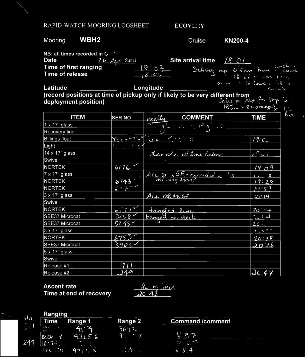
63 Appendix G Logsheets These are scanned images due to past cases of typos being discovered in the logsheets. 63
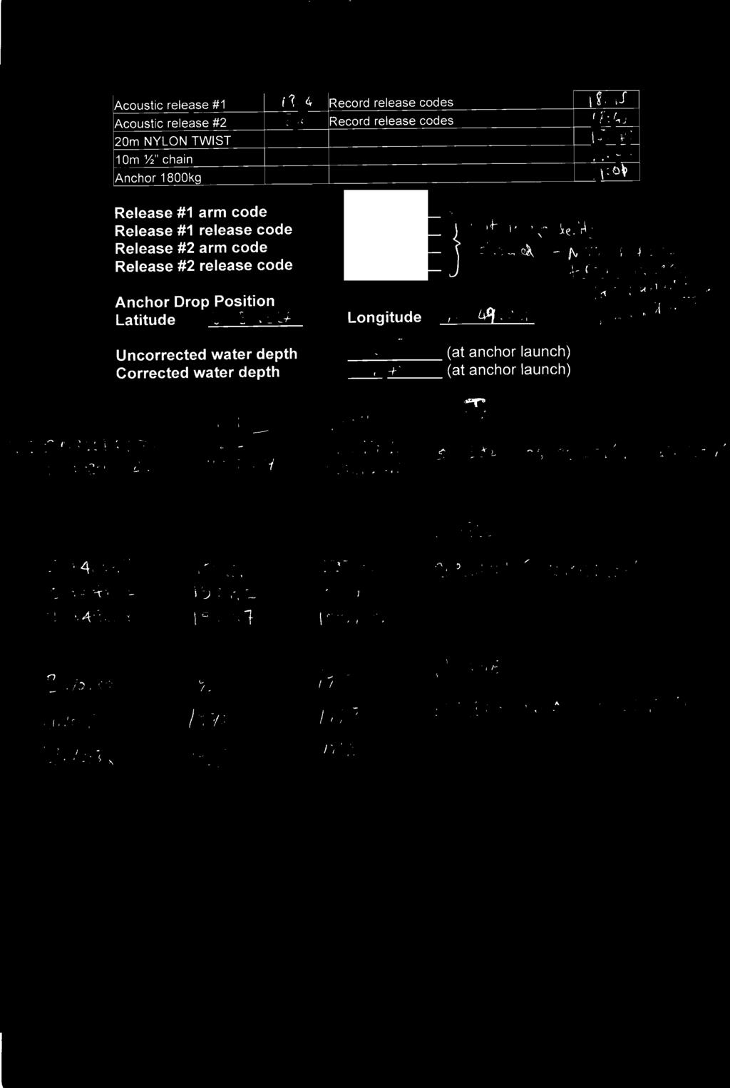
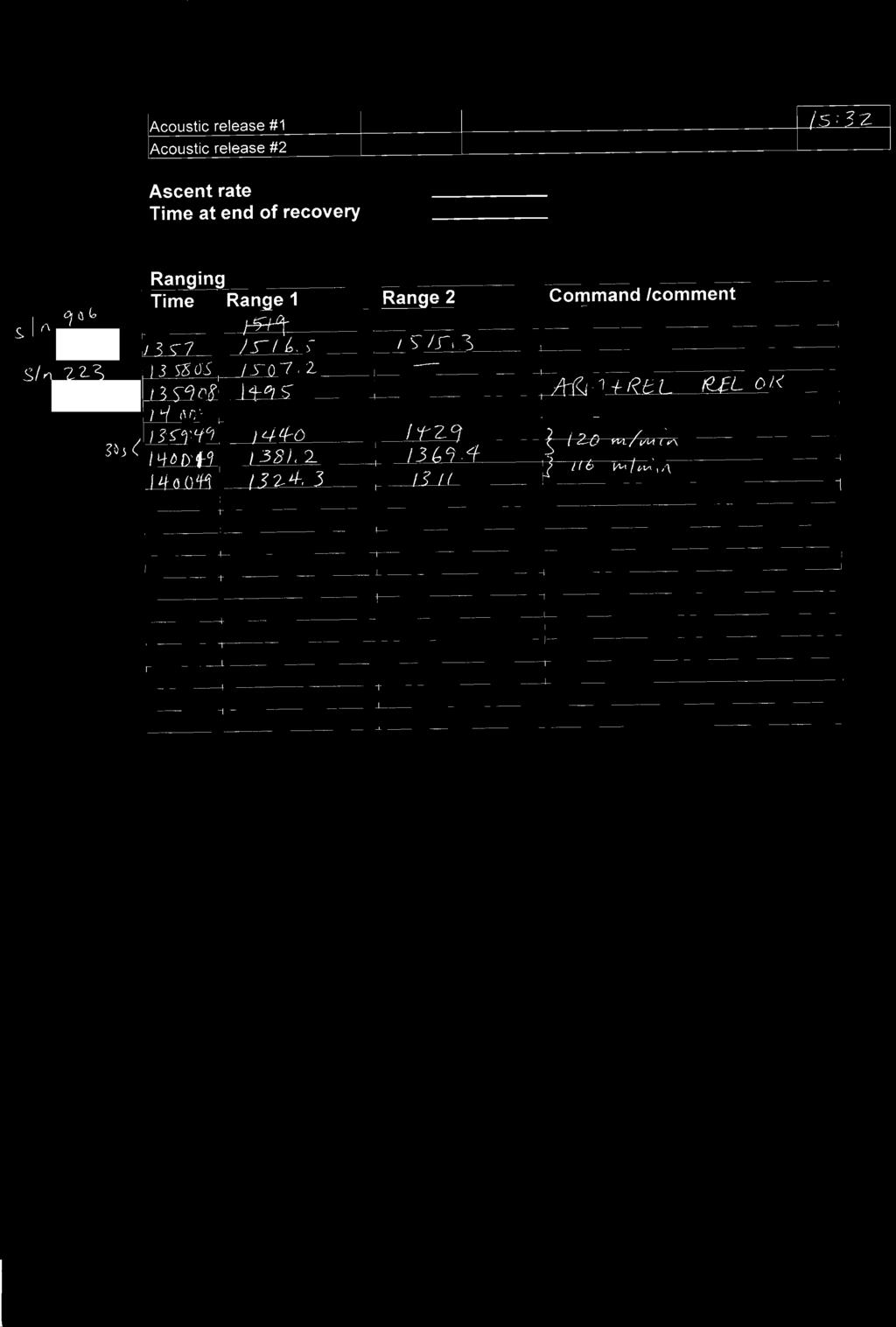
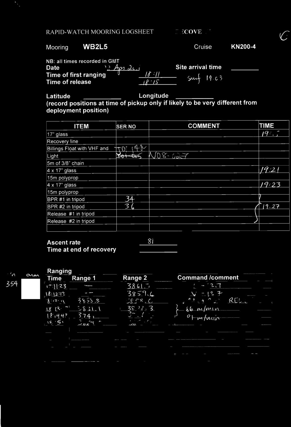
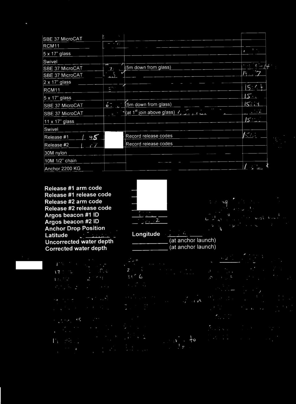
64
65
66
67
68
69
70
71
72
73
74

75
76
77
78
79
80
81
82
83
84
85
86
87
88
89
90

91
92
93
94
95

96
CRUISE REPORT. R/V Knorr Cruise No. KN RAPID/MOCHA Program May 2-26, 2005 St. George, Bermuda - Miami, Florida, USA
 CRUISE REPORT R/V Knorr Cruise No. KN182-2 RAPID/MOCHA Program May 2-26, 2005 St. George, Bermuda - Miami, Florida, USA 1. Introduction and Objectives The RAPID/MOCHA program is a joint research effort
Cruise Report No. 29. RV Ronald H. Brown Cruise RB MAR-10 APR RAPID mooring cruise report
 National Oceanography Centre, Southampton Cruise Report No. 29 RV Ronald H. Brown Cruise RB0701 21 MAR-10 APR 2007 RAPID mooring cruise report Principal Scientists M O Baringer & T Kanzow Editor D Rayner
CRUISE REPORT. R/V Seward Johnson Cruise No. SJ RAPID/MOCHA Program September 25 October 12, 2006 Ft. Pierce to Ft. PIerce, Florida, USA
 CRUISE REPORT R/V Seward Johnson Cruise No. SJ-14-06 RAPID/MOCHA Program September 25 October 12, 2006 Ft. Pierce to Ft. PIerce, Florida, USA 1. Introduction and Objectives The RAPID/MOCHA program is a
REPORT ON THE DEPLOYMENT OF RAPID-WAVE B. O. CORNIDE DE SAAVEDRA RADPROF0910 CRUISE 2010 VIGO-SANTANDER, 30 AUGUST-1 SEPTEMBER 2010
 REPORT ON THE DEPLOYMENT OF RAPID-WAVE MOORINGS OFF CABO MAYOR AND CABO FINISTERRE: RAPIDO B. O. CORNIDE DE SAAVEDRA RADPROF0910 CRUISE 2010 VIGO-SANTANDER, 30 AUGUST-1 SEPTEMBER 2010 MIGUEL ÁNGEL MORALES
R. Weller December 10, 2014 Version 1.3
 1 R. Weller December 10, 2014 Version 1.3 Cruise Plan First deployment of 55 S, 90 W Global Node, RV Atlantis AT26-29, Punta Arenas, Chile February 12, 2015 to Punta Arenas, Chile March 5, 2015 Overview
Cruise Report. FDS Submarine Channels RV Koca Piri Reis. 9 th -26 th May 2010
 Cruise Report FDS Submarine Channels RV Koca Piri Reis 9 th -26 th May 2010 Flow dynamics and sedimentation in an active submarine channel: a process-product approach Principal Scientist J Peakall 2012
ANTARCTIC CROSSROAD OF SLOPE STREAMS expedition aboard B.O. HESPERIDES in the southwest Atlantic Ocean January-February, 2010
 TEXAS A&M UNIVERSITY DEPARTMENT OF OCEANOGRAPHY COLLEGE STATION, TEXAS ACROSS MOORING RECOVERY CRUISE ANTARCTIC CROSSROAD OF SLOPE STREAMS expedition aboard B.O. HESPERIDES in the southwest Atlantic Ocean
DF-99 ANTARCTIC PENINSULA SEDIMENT TRAP DEPLOYMENT AND WATER CHEMISTRY CRUISE R/V N.B. PALMER (MAR 28, 1999 to APR. 12, 1999) David A.
 David A.") DF-99 ANTARCTIC PENINSULA SEDIMENT TRAP DEPLOYMENT AND WATER CHEMISTRY CRUISE R/V N.B. PALMER (MAR 28, 1999 to APR. 12, 1999) by David A. Mucciarone S-072 Cruise Participant: Robert B. Dunbar and David
DF-99 ANTARCTIC PENINSULA SEDIMENT TRAP DEPLOYMENT AND WATER CHEMISTRY CRUISE R/V N.B. PALMER (MAR 28, 1999 to APR. 12, 1999) by David A. Mucciarone S-072 Cruise Participant: Robert B. Dunbar and David
The Past, Present, and Future of Nortek and Glider Measurements
 The Past, Present, and Future of Nortek and Glider Measurements Peter J. Rusello Scientist Nortek Since 2005, Nortek has collaborated with leading researchers to develop specialized acoustic Doppler current
Project: Profiling Float Observations in the Aegean Sea
 Project: Profiling Float Observations in the Aegean Sea Cruise I CRUISE REPORT 1. Introduction and objectives The Profiling Float Observations in the Aegean Sea - Cruise I experiment is a joint effort
Fleet Improvement Committee 7/12/2012
 FleetImprovementCommittee 7/12/2012 In 2009 the UNOLS Fleet Improvement Committee prepared eight debriefing questions to help determine how the unique features of the R/V Sharp have affected cruise operations
RED SEA OUTFLOW EXPERIMENT REDSOX 2
 CRUISE REPORT RED SEA OUTFLOW EXPERIMENT REDSOX 2 R/V Maurice Ewing Cruise EW-110 August 21 to September 12, 2001 1. Introduction and Objectives The Red Sea Outflow Experiment (REDSOX) is a joint effort
Cruise Report YK10-E02
 Cruise Report YK10-E02 (R/V Yokosuka) Site Surveys for IODP expeditions in the Kumano-nada area October 17 19, 2010 Center for Deep Earth Exploration (CDEX) Japan Agency for Marine-Earth Science and Technology
The field program has two main components: Underway Geophysics and On-site Sample collection and detailed mapping.
 AT37 Jeffrey Donnelly "Holocene Hurricanes" Pre-Cruise Meeting 5/31/16 Smith Conference Room (First Floor, Smith Lobby) Agenda Items Mission Objectives: Discovery Bay in Jamaica provides a unique opportunity
Mechanisms Controlling Hypoxia: Integrated Coastal Modeling Field Year 2010
 Mechanisms Controlling Hypoxia: Integrated Coastal Modeling Field Year 2010 Survey cruises on R/V Manta The cruises decribed Dates of cruises: 14 19 June 2010, one half day mobilization. 1 6 August 2010,
Pre-Cruise Meeting 1400 Eastern Time (1100 Pacific), July 1, 2015
, July 1, 2015") Pre-Cruise Meeting 1400 Eastern Time (1100 Pacific), July 1, 2015 Cruise: AT30-02 / Craig Lee, Davis Straits. Sept 6 Sept 25, 2015. Vessel: RV Atlantis General Program Overview: 1. Scientific Objectives:
Pre-Cruise Meeting 1400 Eastern Time (1100 Pacific), July 1, 2015 Cruise: AT30-02 / Craig Lee, Davis Straits. Sept 6 Sept 25, 2015. Vessel: RV Atlantis General Program Overview: 1. Scientific Objectives:
Dilution of Wastewater Discharges from Moving Cruise Ships
 Dilution of Wastewater Discharges from Moving Cruise Ships E. Heinen 1, K. Potts 1, L. Snow 1, W. Trulli 2, D. Redford 1 1 U.S. Environmental Protection Agency 1200 Pennsylvania Ave., N.W. Mail Code 4504T
R/V NEW HORIZON Scripps Institution of Oceanography CRUISE PLAN 1 (Draft = 29 August 2004)
") R/V NEW HORIZON Scripps Institution of Oceanography CRUISE PLAN 1 (Draft = 29 August 2004) Please complete these cruise planning forms and send as an email attachment to shipsked@ucsd.edu. These forms
R/V NEW HORIZON Scripps Institution of Oceanography CRUISE PLAN 1 (Draft = 29 August 2004) Please complete these cruise planning forms and send as an email attachment to shipsked@ucsd.edu. These forms
Short Cruise Report RV Maria S. Merian Cruise MSM 21/1A
 Johannes Karstensen Helmholtz Centre for Ocean Research Kiel GEOMAR Düsternbrooker Weg 20 D-24105 Kiel Tel.: +49 431 600 4156 Fax.: +49 431 600 4102 email: jkarstensen@geomar.de Short Cruise Report RV
Cruise Report for NSF OCE : R/V Endeavor Cruise 531
 I. Quick Summary Cruise Report for NSF OCE-1031050: R/V Endeavor Cruise 531 Cruise number: EN-531 Chief Scientist: Dr. Ruoying (Roy) He Port of Origin: Morehead City, NC Port of Termination: Morehead City,
replacement SONNE status report
 replacement SONNE status report preliminary remark Preliminary remark: Tendering procedure started in 2009. For the first time the tender was for the construction as well as for the operation of the ship
CORALFISH 2009 Cruise Report: CF0609. Eastern Ionian, Cephalonia and Zakynthos
 CORALFISH 2009 Cruise Report: CF0609 15-25 th June 2009 Eastern Ionian, Cephalonia and Zakynthos Dr. Chris Smith & Shipboard Scientific Crew Hellenic Centre for Marine Research CoralFISH: EU Project 213144,
Ocean Gliders and the Argo float program Breck Owens WHOI. for INMARTECH Conference, Oct 06
 Ocean Gliders and the Argo float program Breck Owens WHOI for INMARTECH Conference, Oct 06 A brief history The Argo float program Gliders - how they work Some results from gliders The Future Glider Lineage
GREEK ARGO PROGRAMME PRESENT STATUS AND FUTURE PLANS. G. Korres and D. Kassis HCMR March, 2015
 GREEK ARGO PROGRAMME PRESENT STATUS AND FUTURE PLANS G. Korres and D. Kassis HCMR March, 2015 1. Background and organization of GREEK ARGO activities Greece has established national contribution to the
BERING STRAIT NORSEMAN II 2017 MOORING CRUISE REPORT
 BERING STRAIT NORSEMAN II 2017 MOORING CRUISE REPORT Research Vessel Norseman II, Norseman Maritime Charters Nome-Nome, 7 th July to 15 th July 2017 Rebecca Woodgate, University of Washington (UW), woodgate@apl.washington.edu
Cruise Plan Coastal Pioneer 3 Deployment Leg 2: R/V Knorr Cruise KN December 2014
 Cruise Plan Coastal Pioneer 3 Deployment Leg 2: R/V Knorr Cruise KN-224 10-16 December 2014 Control Number: Version: 1-02 Author: A. Plueddemann Date: November 30, 2014 Approved: Coastal and Global Scale
Antenna Tower Positioning System
 Model 1052 Antenna Tower Positioning System User Manual (Antenna not included) ETS-Lindgren L.P. reserves the right to make changes to any product described herein in order to improve function, design,
HEATHROW COMMUNITY NOISE FORUM
 HEATHROW COMMUNITY NOISE FORUM 3Villages flight path analysis report January 216 1 Contents 1. Executive summary 2. Introduction 3. Evolution of traffic from 25 to 215 4. Easterly departures 5. Westerly
CORALFISH 2010 Cruise Report: CF0910-ROV. Eastern Ionian, Cephalonia Island
 CORALFISH 2010 Cruise Report: CF0910-ROV 24 29 th September 2010 Eastern Ionian, Cephalonia Island Dr. Chris Smith & Shipboard Scientific Crew Hellenic Centre for Marine Research CoralFISH: EU Project
HEATHROW COMMUNITY NOISE FORUM. Sunninghill flight path analysis report February 2016
 HEATHROW COMMUNITY NOISE FORUM Sunninghill flight path analysis report February 2016 1 Contents 1. Executive summary 2. Introduction 3. Evolution of traffic from 2005 to 2015 4. Easterly departures 5.
Cruise Plan Coastal Pioneer 7 Deployment
 Cruise Plan Coastal Pioneer 7 Deployment Leg 1: R/V Armstrong Cruise AR-08A 27 Sep 04 Oct 2016 Leg 2: R/V Armstrong Cruise AR-08B 06 Oct - 14 Oct 2016 Control Number: Version: 1-00 Author: A. Plueddemann
Cruise Plan Coastal Pioneer 2 Deployment R/V Knorr Cruise KN April 2014
 Cruise Plan Coastal Pioneer 2 Deployment R/V Knorr Cruise KN-217 9-11 April 2014 Control Number: Version: 0-01 Author: A. Plueddemann Date: 04/06/2014 Coastal and Global Scale Nodes Ocean Observatories
A project funded by the International Joint Ventures Fund of the Canada Foundation. for Innovation
 A project funded by the International Joint Ventures Fund of the Canada Foundation for Innovation in collaboration with the Department of Fisheries & Oceans-Canadian Coast Guard Canadian consortium of
Deepwater Horizon Oil Spill Principal Investigator One Year Update Workshop
 Deepwater Horizon Oil Spill Principal Investigator One Year Update Workshop Wave Glider Monitoring the Gulf of Mexico Graham Hine Senior Vice President of Operations Liquid Robotics, Inc. 25 October, 2011
CRUISE REPORT (C.M. Young, January 8, 2014)
") CRUISE REPORT (C.M. Young, January 8, 2014) University of Oregon North Carolina State University Duke University Ship: R/V Pelican Cruise Dates: November 4-8, 2013 Scientific Party: Dr. Craig Young, Chief
CRUISE REPORT (C.M. Young, January 8, 2014) University of Oregon North Carolina State University Duke University Ship: R/V Pelican Cruise Dates: November 4-8, 2013 Scientific Party: Dr. Craig Young, Chief
CRUISE REPORT FOR BERING STRAIT MOORING PROJECT
 CRUISE REPORT FOR BERING STRAIT MOORING PROJECT 2007 Russian Vessel SEVER ( North ) RUSALCA2007 Nome, 27 th August 2007 Nome, 5 th September 2007 Rebecca Woodgate, University of Washington (UW),woodgate@apl.washington.edu
R/V Revelle, Alford Cruise Cruise Plan, 6/1/2010
 R/V Revelle, Alford Cruise Cruise Plan, 6/1/2010 Overview The following is the cruise plan for the Internal Waves in Straits Experiment (IWISE) pilot leg (27 at-sea days) of the IWISE/ITOP projects. Our
LAKE TITICACA, BOLIVIA SEDIMENT TRAP DEPLOYMENT CRUISE ON LAKE TITICACA March 20-26, 2002
 LAKE TITICACA, BOLIVIA SEDIMENT TRAP DEPLOYMENT CRUISE ON LAKE TITICACA March 20-26, 2002 by David A. Mucciarone S-072 Cruise Participant: Robert B. Dunbar, David A. Mucciarone, and Christopher Moy all
Profiling Float Observations in the Aegean Sea
 Profiling Float Observations in the Aegean Sea Sarantis S. Sofianos University of Athens, Department of Applied Physics Ocean Physics and Modelling Group University Campus, BUILD PHYS-5 Athens 15784, GREECE
Potomac River Commuter Ferry Feasibility Study & RPE Results
 1.1 Introduction The Prince William County Department of Transportation conducted a route proving exercise (RPE) and feasibility study of a proposed commuter ferry service on the Potomac River between
NEW SOUTH WALES. Both METRIC and Feet and Inches TIMES: am/pm Sunrise/Sunset Moon Phases Moon Rise/Set DIARY NOTES.
 2016 2014 November 28, 2013 November 26, 2015 TO to January 4, 7, 2017 2015 Both METRIC and Feet and Inches TIMES: am/pm Sunrise/Sunset Moon Phases Moon Rise/Set DIARY NOTES NEW SOUTH WALES Public Works
SERVICE LETTER REVISION
 Citation Revision 1 SERVICE LETTER REVISION SL750-71-13 TRANSMITTAL SHEET This sheet transmits Revision 1 to SL750-71-13. A. Attaches the latest revision of the Rolls-Royce Notice To Operators (NTO) Number
1 of 5 9/19/2014 3:24 PM
 1 POC: Liz Caporelli LAST UPDATED: 2008/01/21 09:36 EST Marine Operations Woods Hole Oceanographic Institution 38 Water St Mail Stop-37 Tel: 508-289-2277 Fax: 508-457-2185 Email: ecaporelli@whoi.edu R/V
CRUISE TABLE OF CONTENTS
 CRUISE FLIGHT 2-1 CRUISE TABLE OF CONTENTS SUBJECT PAGE CRUISE FLIGHT... 3 FUEL PLANNING SCHEMATIC 737-600... 5 FUEL PLANNING SCHEMATIC 737-700... 6 FUEL PLANNING SCHEMATIC 737-800... 7 FUEL PLANNING SCHEMATIC
PHY 133 Lab 6 - Conservation of Momentum
 Stony Brook Physics Laboratory Manuals PHY 133 Lab 6 - Conservation of Momentum The purpose of this lab is to demonstrate conservation of linear momentum in one-dimensional collisions of objects, and to
FINAL REPORT West Coast Naval Training Range Demonstration of Glider-Based Passive Acoustic Monitoring
 DISTRIBUTION STATEMENT A. Approved for public release; distribution is unlimited. FINAL REPORT West Coast Naval Training Range Demonstration of Glider-Based Passive Acoustic Monitoring John A. Hildebrand
Nature of MATE Internships in 2011 thru May UNOLS/USCG Interns
 Name 1 Erik Arnesen 2 Mark Burnap Institution Sonoma State Southern Oregon Nature of MATE Internships in 2011 thru May 2014 Internship Host R/V Wecoma (six-month intern) 3 Jaclyn Chariw Kutztown R/ V Thompson
REPORT IN-038/2010 DATA SUMMARY
 REPORT IN-038/2010 DATA SUMMARY LOCATION Date and time Friday, 3 December 2010; 09:46 h UTC 1 Site Sabadell Airport (LELL) (Barcelona) AIRCRAFT Registration Type and model Operator EC-KJN TECNAM P2002-JF
R/V Maurice Ewing Replacement
 R/V Maurice Ewing Replacement 3D Seismic Vessel Western Legend Replacement Vessel Western Legend as an Example (EWING after midlife in parenthesis) Length: 235 feet (237 feet) Beam: 56 feet (46 feet) Displacement
FLIGHT OPERATIONS INTRODUCTION ICAO Air Navigation Commission
 FLIGHT OPERATIONS INTRODUCTION ICAO Air Navigation Commission Access is a huge problem 2 out of 3 people in the world are not connected to the internet current solutions fail to effectively serve the needs
$6.60 NEW SOUTH WALES. Both METRIC and Feet and Inches TIMES: am/pm Sunrise/Sunset Moon Phases Moon Rise/Set DIARY NOTES.
 $6.60 (incl. GST) 2018 2014 November 28, 2013 November 23, 2017 TO to January 2, 7, 2019 2015 Both METRIC and Feet and Inches TIMES: am/pm Sunrise/Sunset Moon Phases Moon Rise/Set DIARY NOTES NEW SOUTH
Table of Contents. Introduction to the AquaTrak AquaTrak Parts List Tank Frame Assembly Pulley System Assembly...
 56679 V0309 Table of Contents Introduction to the AquaTrak................................................... 2 AquaTrak Parts List... 3 Tank Frame Assembly... 4 Pulley System Assembly... 6 AquaTrak Maintenance...10
Revalidation: Recommendations from the Task and Finish Group
 Council meeting 12 January 2012 01.12/C/03 Public business Revalidation: Recommendations from the Task and Finish Group Purpose This paper provides a report on the work of the Revalidation Task and Finish
Sinking Wreckage Trajectory Study. El Faro DCA16MM001. March 20, 2016
 NATIONAL TRANSPORTATION SAFETY BOARD Office of Research and Engineering Washington, DC Sinking Wreckage Trajectory Study DCA16MM001 March 20, 2016 Crider Dennis Contents Figures... 2 1. Accident Information...
CPP failure caused heavy contact with lock
 December 2016 CPP failure caused heavy contact with lock The vessel was berthed alongside a quay, waiting to proceed through a lock to another berth. The pilot called on the radio and informed the master
USER MANUAL BMU WORKCAGE. CONFORM TO THE MACHINE DIRECTIVE 2006/42/EC and to EN1808 (1999)
") USER MANUAL BMU WORKCAGE CONFORM TO THE MACHINE DIRECTIVE 2006/42/EC and to EN1808 (1999) All persons operating this equipment must read and completely understand this manual. Any operation in violation
USER MANUAL BMU WORKCAGE CONFORM TO THE MACHINE DIRECTIVE 2006/42/EC and to EN1808 (1999) All persons operating this equipment must read and completely understand this manual. Any operation in violation
Produced by: Destination Research Sergi Jarques, Director
 Produced by: Destination Research Sergi Jarques, Director Economic Impact of Tourism Oxfordshire - 2015 Economic Impact of Tourism Headline Figures Oxfordshire - 2015 Total number of trips (day & staying)
Minutes taken by Becky Conway. William Heaps, Ian Russell, Mark Poole and Martin Stemp, Malcolm Bowdidge. Agenda Item Details Action:
 The Hydrographic Society of the United Kingdom (Southern Region) Annual General Meeting Minutes Secretary: Attendees: Apologies: Minutes taken by Becky Conway Maik Weidt (Chair) Becky Conway Ken Collins
Summary THE FRAM STRAIT TOMOGRAPHY EXPERIMENT 2008
 A non-profit Research institute affiliated With the University of Bergen Thormøhlensgate 47 N-5006 Bergen, Norway http://www.nersc.no Summary THE FRAM STRAIT TOMOGRAPHY EXPERIMENT 2008 Project Leader:
R/V «Dr. Fridtjof Nansen» - Fishery and oceanographic research vessel
 Information to cruise participants on board "Dr. Fridtjof Nansen" Ref.id.: KS&SMS-3-2.13.2-06 Standard Side 1 av 7 R/V «Dr. Fridtjof Nansen» - Fishery and oceanographic research vessel Ref.id.: KS&SMS-3-2.13.2-06
C. Area of operation: Columbia River and Columbia River Estuary between mouth of estuary and Portland, Oregon.
 R/V Barnes Cruise Plan July 2008 Cruise dates: July 7 24 Captain: Ray McQuin Lead scientist: Joseph Needoba (needobaj@stccmop.org) Funding source: NSF PI Antonio Baptista Organization: NSF Center for Coastal
$6.60 NEW SOUTH WALES. Both METRIC and Feet and Inches TIMES: am/pm Sunrise/Sunset Moon Phases Moon Rise/Set DIARY NOTES.
 $6.60 (incl. GST) 2019 2014 November 28, 2013 November 22, 2018 TO to January 1, 7, 2020 2015 Both METRIC and Feet and Inches TIMES: am/pm Sunrise/Sunset Moon Phases Moon Rise/Set DIARY NOTES NEW SOUTH
Flight inspection service of LGS Radionavigation Aids in 2017
 Annex 5 1. Subject TECHNICAL SPECIFICATION Flight inspection service of LGS Radionavigation Aids in 2017 (identification Nr. LGS 2016/107) 1.1. Flight inspection of LGS radio navigation aids for one year.
HOT 293: Chief Scientist Report Chief Scientist: Dan Sadler R/V Ka'Imikai-O-Kanaloa May 22-26, 2017
 HOT 293: Chief Scientist Report Chief Scientist: Dan Sadler R/V Ka'Imikai-O-Kanaloa May 22-26, 2017 Cruise ID: KOK17-10 Departed: May 22, 2017 at 0750 (HST) Returned: May 26, 2017 at 0943 (HST) Vessel:
2018 WSGC WISCONSIN COLLEGIATE ROCKET DESIGN COMPETITION
 2018 WSGC WISCONSIN COLLEGIATE ROCKET DESIGN COMPETITION 11-NOV-2017 1 Welcome WSGC 2018 CRL 2 Agenda Who is competing? What is the challenge? When and where will events be taking place? When are the important
GENERAL INFORMATION Aircraft #1 Aircraft #2
 GENERAL INFORMATION Identification number: 2007075 Classification: Serious incident Date and time 1 of the 2 August 2007, 10.12 hours occurrence: Location of occurrence: Maastricht control zone Aircraft
PASSUR Aerospace. Departure Metering Program at Toronto Pearson International Airport. Training Manual
 PASSUR Aerospace Toronto Pearson International Airport Departure Metering Program at Toronto Pearson International Airport Training Manual Name: Today s Date: Toronto Pearson Deicing Sequencing Training
Quick Start Guide 3500 AquaVent
 Quick Start Guide 3500 AquaVent Please read this document carefully before using the AquaVent. High Quality Groundwater and Surface Water Monitoring Instrumentation Note: For information on using your
Installation and Maintenance Manual
 Freestanding Gas Stove MODEL: PGS2005 GPEBB20R GPEBW20R Installation and Maintenance Manual Warning Maintenance products should be carried out by professional and technical personnel with relevant qualification,
system: with specific focus to the Mediterranean, the Black Sea and the Southern Seas (Antarctic) sponsored by MUIR since 2011 (0.
 sponsored by MUIR since 2011 (0.") The results of Argo-Italy: floats, drifters and gliders in the Mediterranean Pierre-Marie Poulain OGS, Trieste, Italy Argo-Italy Program Outline Observations collected in the Mediterranean in 2012-2013
The results of Argo-Italy: floats, drifters and gliders in the Mediterranean Pierre-Marie Poulain OGS, Trieste, Italy Argo-Italy Program Outline Observations collected in the Mediterranean in 2012-2013
SAFETY MANAGEMENT MANUAL 3.1 Responsibilities and Authority
 1. Purpose The purpose of this procedure is to set forth the Safety Management System responsibilities and authorities as they exist at WHOI in the operation of the oceanographic vessels. 2. Scope The
INSTRUCTION MANUAL ALEKO RETRACTABLE AWNING
 INSTRUCTION MANUAL for ALEKO RETRACTABLE AWNING www.alekoproducts.com FAILURE TO FOLLOW THESE INSTRUCTIONS MAY RESULT IN PERSONAL INJURY! 1 Important Safety Precautions WARNING NOTE: FOR PERSONAL SAFETY,
CONGESTION MONITORING THE NEW ZEALAND EXPERIENCE. By Mike Curran, Manager Strategic Policy, Transit New Zealand
 CONGESTION MONITORING THE NEW ZEALAND EXPERIENCE 26 th Australasian Transport Research Forum Wellington New Zealand 1-3 October 2003 By, Manager Strategic Policy, Transit New Zealand Abstract New Zealand
Self-Guided Group Organization - Recommendations
 Self-Guided Group Organization - Recommendations Introduction The purpose of this document is to offer a template to self-guided groups with respect to pre-trip and on-trip planning. The ultimate goal
Assembly. Step 3. Attach the safety bracket (7) to the Pivot ARM (6).
 to the Pivot ARM (6).") Assembly Step 1. A. Stand the base of the machine by separating the U-frames (1,2). Pull the Front and Rear U-Frames (1,2) as far apart from each other as possible. Then push down on the middle of the
Assembly Step 1. A. Stand the base of the machine by separating the U-frames (1,2). Pull the Front and Rear U-Frames (1,2) as far apart from each other as possible. Then push down on the middle of the
NOTIFICATION OF PROPOSED RESEARCH CRUISE
 NOTIFICATION OF PROPOSED RESEARCH CRUISE PART A: GENERAL 1. NAME OF RESEARCH SHIP FS POSEIDON CRUISE NO. P303 2. DATES OF CRUISE From: 11/09/2003 To: 06/10/2003 3. OPERATING AUTHORITY Institut fuer Meereskunde
AIRBUS Generic Flight Test Installation
 AIRBUS Generic Flight Test Installation Jean-Pascal CATURLA AIRBUS Operations SAS, Toulouse, France ABSTRACT This paper describes new concepts of test mean and processes to perform flight test for all
HOT 294: Chief Scientist Report Chief Scientist: Dan Sadler R/V Kilo Moana June 19-23, 2017
 HOT 294: Chief Scientist Report Chief Scientist: Dan Sadler R/V Kilo Moana June 19-23, 2017 Cruise ID: KM 17-08 Departed: June 19, 2017 at 1000 (HST) Returned: June 23, 2017 at 0815 (HST) Vessel: R/V Kilo
LAKE TITICACA, BOLIVIA/PERU HIGH RESOLUTION SINGLE CHANNEL SEISMIC SURVEY CRUISE ON LAKE TITICACA ON THE M/V YAKUZA 15 APRIL TO 29 APRIL 1996
 LAKE TITICACA, BOLIVIA/PERU HIGH RESOLUTION SINGLE CHANNEL SEISMIC SURVEY CRUISE ON LAKE TITICACA ON THE M/V YAKUZA 15 APRIL TO 29 APRIL 1996 Cruise participant: David A. Mucciarone from Rice University,
Produced by: Destination Research Sergi Jarques, Director
 Produced by: Destination Research Sergi Jarques, Director Economic Impact of Tourism Norfolk - 2017 Contents Page Summary Results 2 Contextual analysis 4 Volume of Tourism 7 Staying Visitors - Accommodation
Air Accident Investigation Unit Ireland. FACTUAL REPORT ACCIDENT Colibri MB-2, EI-EWZ ILAS Airfield, Taghmon, Co. Wexford
 Air Accident Investigation Unit Ireland FACTUAL REPORT ACCIDENT Colibri MB-2, EI-EWZ ILAS Airfield, Taghmon, Co. Wexford 9 June 2017 Colibri MB2, EI-EWZ ILAS Airfield, Co. Wexford 9 June 2017 FINAL REPORT
National Transportation Safety Board
 Accident no. Vessel names Accident type Location DCA15RM024 Courage Fire Date June 2, 2015 National Transportation Safety Board Marine Accident Brief Fire aboard Vehicle Carrier Courage North Sea in the
ARRIVAL CHARACTERISTICS OF PASSENGERS INTENDING TO USE PUBLIC TRANSPORT
 ARRIVAL CHARACTERISTICS OF PASSENGERS INTENDING TO USE PUBLIC TRANSPORT Tiffany Lester, Darren Walton Opus International Consultants, Central Laboratories, Lower Hutt, New Zealand ABSTRACT A public transport
ACCIDENT. Aircraft Type and Registration: Piper PA Cherokee, G-BRWO. No & Type of Engines: 1 Lycoming O-320-E3D piston engine
 ACCIDENT Aircraft Type and Registration: No & Type of Engines: Piper PA-28-140 Cherokee, G-BRWO 1 Lycoming O-320-E3D piston engine Year of Manufacture: 1973 Date & Time (UTC): Location: Type of Flight:
Marine Exchange of Alaska Port of Juneau Navigation Study
 Safe, Secure, Efficient and Environmentally Responsible Maritime Operations 1000 Harbor Way, Juneau, Alaska 99801 Ph: (907) 463-2607 December 10, 2008 Mr. John Stone Port Director City of Juneau 155 S.
Cruise Plan Coastal Pioneer 6 Deployment
 Cruise Plan Coastal Pioneer 6 Deployment Leg 1: R/V Armstrong Cruise AR-04A 12 May 15 May 2016 Leg 2: R/V Armstrong Cruise AR-04B 17 May - 24 May 2016 Leg 3: R/V Armstrong Cruise AR-04C 26 May - 2 June
Coordination Center German Research Vessels
 Coordination Center German Research Vessels Experiences with RV SONNE Tina Knuth University Hamburg Coordination Center German Research Vessels coordinates the worldwide activities of following research
Written by: Kate Florio, Liberty Science Center. Grade Level: change when the mass of an object changes. 20 mins. Lesson Time: 45 min.
 A Classroom Activity for Ocean Gazing Episodes 13, 15, 24 & 49: Autonomous, enormous, ingenious; Gliding on Earth; The little sub that could; Slick of oil Written by: Kate Florio, Liberty Science Center
CESSNA SECTION 5 PERFORMANCE
 CESSNA SECTION 5 TABLE OF CONTENTS Page Introduction............................................5-3 Use of Performance Charts................................5-3 Sample Problem........................................5-4
Produced by: Destination Research Sergi Jarques, Director
 Produced by: Destination Research Sergi Jarques, Director Economic Impact of Tourism Epping Forest - 2014 Economic Impact of Tourism Headline Figures Epping Forest - 2014 Total number of trips (day & staying)
Summary Report. Contact with Wharf General Villa. 5 March 2006
 Summary Report Contact with Wharf 5 March 2006 NARRATIVE arrived at Napier pilot station at 0442 hours on 5 March 2006, having sailed from Bluff two days earlier The Pilot boarded at 0457 hours The Master
POL Glider Facility (July 2009)
") No. 192 POL Glider Facility (July 2009) Phil Knight, Chris Balfour, John Kenny and Danny McLaughlin July 2009 POL Glider Facility (July 2009) Phil Knight, Chris Balfour, John Kenny & Danny McLaughlin
No. 192 POL Glider Facility (July 2009) Phil Knight, Chris Balfour, John Kenny and Danny McLaughlin July 2009 POL Glider Facility (July 2009) Phil Knight, Chris Balfour, John Kenny & Danny McLaughlin
Water masses and circulation in the North Atlantic
 Ocean and Climate Change, March 30, 2012, Paris Water masses and circulation in the North Atlantic Monika Rhein, Universität Bremen Dagmar Kieke, Christian Mertens, Achim Roessler, and Reiner Steinfeldt
SOLHARO ASSEMBLY & INSTALLATION INSTRUCT IONS
 A. Introduction: SOLHARO ASSEMBLY & INSTALLATION INSTRUCT IONS Rev. 01/30/2012 The Solharo is an external, retractable, tensioned sun shading system designed to fit over a sunroom or wood pergola. The
Stories from Maritime America
 Sam Casarez Sam Casarez describes his experiences as a junior engineer aboard a Liberty ship during World War II. Engine room training I trained for the engine room. You could train for the engine room
1. Enclosure (1) i s forwarded to accordance with referance (a).
 i s forwarded to accordance with referance (a).") USS GRAPPLE (ARS-53) CIO FPO NEW YORK. NEW YORK 09570-3223 5750 From: Commanding Officer, USS GRAPPLE (ARS 53) To: Director of Naval History (OP-098~) Subj: COMMAND HISTORY OF USS GRAPPLE (ARS 53) Ref:
USS GRAPPLE (ARS-53) CIO FPO NEW YORK. NEW YORK 09570-3223 5750 From: Commanding Officer, USS GRAPPLE (ARS 53) To: Director of Naval History (OP-098~) Subj: COMMAND HISTORY OF USS GRAPPLE (ARS 53) Ref:
BUSINESS BAROMETER December 2018
 Credit: Chris Orange BUSINESS BAROMETER December Credit: Nigel Moore 1 Contents Summary of findings 3 Annual monthly performance: visitor attractions..4 Visit Herts Team update 5 National context.8 Visitor
Capabilities for Gliders
 A New World of Velocity Profile Capabilities for Gliders by Eric Siegel, General Manager, Nortek USA Ocean gliders are autonomous underwater vehicles that profile the water column vertically by controlling
Produced by: Destination Research Sergi Jarques, Director
 Produced by: Destination Research Sergi Jarques, Director Economic Impact of Tourism North Norfolk District - 2016 Contents Page Summary Results 2 Contextual analysis 4 Volume of Tourism 7 Staying Visitors
Produced by: Destination Research Sergi Jarques, Director
 Produced by: Destination Research Sergi Jarques, Director Economic Impact of Tourism Norfolk - 2016 Contents Page Summary Results 2 Contextual analysis 4 Volume of Tourism 7 Staying Visitors - Accommodation