Chapter 10 CANADA. Last one in Unit 3! Wooo hooo! So much info, but so interesting!
|
|
|
- Kathlyn Fowler
- 5 years ago
- Views:
Transcription
1 Chapter 10 CANADA Last one in Unit 3! Wooo hooo! So much info, but so interesting!
 Many raw materials are extracted and sent globally British & French roots")
2 Canada Dontcha know, eh? 2nd largest country in the world! One of the smallest populations. Much in common w/ USA World s longest peaceful border in history! 3,987 mile border w/ L48 1,538 mile borer w/ AK One of the richest & most industrialized nations in the world (like USA) Many raw materials are extracted and sent globally British & French roots crafted from the wilderness Shared history at times, shared geographic features

3 Population distribution of Northern America 1 dot represents 10,000 persons What do you see from Canada & USA?

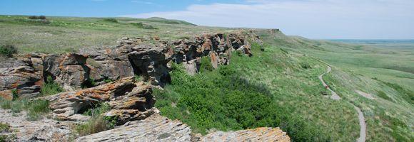
4 The Maritime Provinces 10 provinces in Canada total 4 smallest are located in the eastern corner along the Atlantic Coast known as the maritime provinces maritime : bordering the sea Citizens of these territories depend upon the sea for living a way of life Seafood fish, lobster, etc Remember the Cod fishery being shut down? Whaling oil
 Rocky coasts, rolling hills are covered by stunted")

5 Newfoundland NOO fun land new found land Island & a large, rocky strip of land on the mainland As of 1964, the name is officially Newfoundland and Labrador Gives both parts of the province equal honor A Rural Island Is actually the northern edge of the Appalachian Mountain system (portion lies underwater) Rocky coasts, rolling hills are covered by stunted forests (dwarfed trees) Fjords gouged by glaciers Bird sanctuaries puffins Most citizens live on the island Cool climate, but Gulf Stream keeps cold from becoming too harsh Capital: St. John s Sits near Grand Banks world famous fishing grounds (esp. cod!) Viking outpost was located here England claimed in 1583, but did not settle for fear of local natives ability to fish better

6 Newfoundland Native fisherman built winter camps in coves (small, sheltered bays) that dotted the coast England couldn t compete with this very well then In fact, local fisherman dominated in the way for centuries until finally joining Canada in 1949, as the last province to join the federation Labrador Peninsula off the mainland is cold year round Frigid Labrador Current carries Arctic water and icebergs past the coast Air temps dip below -50 F in winter Surface coastal waters actually freeze into a special ice called ballicater Fresh caught fish freeze nearly instantly when caught during these times! (haha!) actually led to the frozen fish industry because it kept the fish fresher longer Clarence Birdseye in 1915 Rocky tundra covers the north & in the south thick forests of spruce and pine Several mountains have alpine summits Mount Caubvick (highest peak east of the Canadian Rockies) dominates the Torngat Range World s largest herd of caribou migrate to Labrador in spring to calve
 Canadian dialect: `My face was frore, my collars was frore, an' everything was ballicatered.")
7 Newfoundland Underneath Labrador s rocky mountains like zinc and iron ore Labrador City s mine produce more iron than any other province Only Minnesota produces more iron than Newfoundland Logging takes place in the summer months Produce newsprint (cheaper paper for newspapers) Canadian dialect: `My face was frore, my collars was frore, an' everything was ballicatered.... I couldn't hear her now, way I was muffled up, 'cause I was ballicatered up - I was frore up.'' That is Newfoundland English, at least what you might hear from an outport fisherman. It's quoted in the Dictionary of Newfoundland English in a reference to the verb ``ballicater'' - to cover with a layer of ice. The speaker also uses a word from West Country England, ``frore'' or ``vrore,'' meaning frozen solid. Presumably he's talking about being out on a windy, cold day with the sea water splashing, and freezing on his boat, his face and neck cold, but his head wrapped up in enough clothing so that he can hardly hear.(10/20/1988)


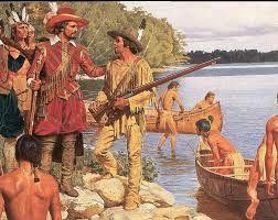
8 Acadia 3 southernmost Maritime Provinces were settled by the French New Brunswick, Prince Edward Island, Nova Scotia French named the region Acadia Port Royal, the first French settlement in the New World in 1604 in the Bay of Fundy in Nova Scotia Henry Wadsworth Longfellow's poem Evangeline helped make Acadia famous Tells of a tragic conflict between British & French settlers 1621 trouble beings when Scottish colonists arrive and claim land that the French wanted After multiple wars the Treaty of Utrecht in 1713 awarded the area to GB Disputes continue 1755, GB decides to resolve the problem by forcing thousands of the French Acadians out of their homes and shipping them south Some settled in New Orleans become Cajuns Some escaped in the Acadian wilderness French is still spoken and French culture is still prevalent


 Canso Strait is the deepest water ever bridged!")
9 Nova Scotia Once home to the largest French settlement, but most were removed by the British, and now descendents are mainly of British Scottish named the province New Scotland Nova Scotia long, narrow peninsula surrounded by ocean except for one 20-mile strip that connects it to the mainland A.k.a. The Ocean Province sandy beaches are always around Canso Causeway connects the island to Cape Breton Island The Atlantic Upland dominates the land (similar to Maine) Canso Strait is the deepest water ever bridged! Few coastal lowlands permit fruit growing and dairy farming Forests provide many of the Christmas trees sold throughout Canada Capital: Halifax largest port, city, and industrial area in the Maritime Provinces Leader in lobster and scallop catch


 Appalachian Mts extend into the northern parts of NB are mined for lead, copper and")
10 New Brunswick French Acadians make up 40% of the NB Represent the 2nd largest French population in Canada after Quebec Others are mainly of British descent or American Loyalists/Tories who fled to Canada only Maritime Province to share a border with USA Mostly coastal lowlands Not where we get the stew that comes from Brunswick County, NC Farmers grow potatoes (like Maine) SW is a continuation of the Atlantic Uplands (like maine) Appalachian Mts extend into the northern parts of NB are mined for lead, copper and zinc Forests provide lumber
 Home of Anne of Green Gables Crowded island is actually quite rural and spread out Just seems crowded compared to the rest of Canada s large wilderness A.")

11 Prince Edward Island (PEI) Who the heck is Prince Edward?! Previously called St. Johns (and still referred sometimes as such) Home of Anne of Green Gables Crowded island is actually quite rural and spread out Just seems crowded compared to the rest of Canada s large wilderness A.k.a Spud Island as a leader in potato production House of Green Gables at Cavendish, PEI, inspired AofGG Smallest Canadian Province (just a little larger than Delaware) Capital: Charlottetown Farmland supports the highest population density of any Canadian prov. ~62 ppl/ sq. mi Duke of Kent ( ) 4th son of King George III, and father of Queen Victoria Red rusted oxide soil is great arable land and fertile Beef & dairy cattle enjoy pasturelands Quaint villages and sandy beaches make the scenery picturquese and inviting 1996 bridge connecting to mainland was completed after much dispute Most descendants are of Scottish heritage bagpipes and kilts common Many last names have a Mac
 Mainly due to the irregular coast shape funnel-like Tides affected")

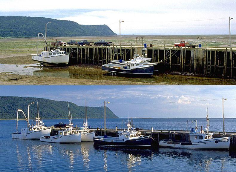
12 Bay of Fundy In between Nova Scotia & New Brunswick Most famous bay of the Atlantic Ocean Has the highest tides in the world 40 feet difference between 12 hours (5 story bldg) Mainly due to the irregular coast shape funnel-like Tides affected by moon s gravitational pull Tide also affects the St. John River by making the rapids flow backwards The Rocks are dry, beach like at low tide, but at high tide, they are mostly covered l5wl3m (time lapse video)
13
14 SRQ Pg What two European countries competed for control of Canada? Who is Canada's major trading partner? Contrast Newfoundland with the provinces of Acadia. What causes tides? Where are they highest? Name a major product in each Maritime Province. List all the similarities you can find between Maine and the Maritime Provinces.
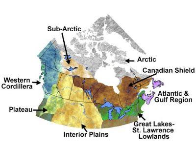
15 The Central Provinces Canada lies far above the Equator, so the sun provides little warmth Huge inland areas lack the moderation of the oceans (water maintains temp better) Because of the weather, most cities are in the south of Canada (Southern strip/ US border) less severe weather ⅔ of all Canadians live within 100 miles of US border Ribbon development: the building of farms, towns, and industries along a narrow band of good land Humid continental climate region along Great Lakes and St. Lawrence River Canada s ribbon development with the 100 miles Summer temps get into 80s here, farmlands remain frost free for nearly 6mo. Quebec & Ontario here rich plains Pioneers cleared mixed forests of pine, hemlock, sugar maple, beech Few ppl live in the northland Canadian Shield: solid mass of har rock covers most of north & surrounds the Hudson Bay like a giant horshoe
16 The Central Provinces Thin, poor soil in Canadian Shield Subpolar climate dominates the Canadian Shield Needle-leaf evergreen trees spruce, pine, fir are the only trees that grow But become increasingly stunted as travel north Coniferous forests, called tiaga, cover most of the Central Provinces Most likely that glacier scrapped the land and wore down mountains and hills, exposing the bedrock Glaciers also cut out many depressions for lakes and even some marshes Area is good for mining with rich deposits of iron, copper, gold, lead, zinc and cobalt Moose, eavers, and black bears live in the cool forests Insects are plentiful in warm months Northern extremes give way to tundra where no trees grow Remember: frozen desert?


17 Quebec
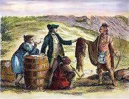
18 Quebec A.k.a. The French Heartland Capital: Quebec (Quebec City) Earliest explorers to Canada were Frenchmen Jacques Cartier, Samuel de Champlain, and Robert de la Salle (mapped Great Lakes & St. Lawrence River) Named the region New France (Original? New England, New Spain, New Jersey, New Netherlands, New York, New Hampshire, etc.) FURS $$ Mink, beaver, otter, muskrat Men who hunted animals for furs were called coureurs de bois ( runners of the wood koo-rer de BWAH Became part of Canadian folklore (similar to US cowboys, frontiersmen, etc) Crisscrossed the interior lakes and frigid rivers & Often times had to carry canoes on back for miles until reaching the next river/lake Portage: FR describes the land routes used by canoe toters French traded with Huron Indians (Lake Huron) English started Hudson Bay Company started trade w/ Algonquian Indians Eng began to squeeze French out economically and territorially Seven Years War a.k.a. The French & Indian War ( ) raised the question of how to treat the French
19 Quebec CONTRAST to USA: 1974 French became the sole official language of Quebec Melting pot Canada refers to their cultural makeup as a cultural mosaic Meaning the varied people who have settled Canada have retained more of their specific cultural (distinct attributes) identity than Americans Easily seen in Quebec 95% of residents speak French, some 80% would classify French as their native tongue All government docs and road signs are in French People from Quebec are called Quebecois Kay beh KWAH Cities of the St. Lawrence Valley Most productive land lies in the St. Lawrence Valley (southern edge of the providence) Season just enough for fruits to grow, some vegetables (cold veg), and some grains Leads nation in dairy production, maple syrup Most people live here Quebec City Capital & 2nd largest city 1608 Overlooks St. Lawrence River Cradle of French Civ. in New World/N Am. French built only walled city north of Mexico here (QC) captured in 1759 by GB ending Fr rule in Canada
 Located at the farthest navigable point")


20 Quebec Cities of the St. Lawrence Valley (cont.) Montreal Largest city Located on an island in the middle of St. Lawrence River Named by Cartier Mont Réal Fr Mount Royal after climbing the highest point (700 feet) Located at the farthest navigable point of the river became the commercial center of the province Over 1.75 million inhabitants Second largest French speaking city in the world 2nd only to Paris Large minority of English speakers Offer both Fr & Eng newspapers, schools, radio, tv, etc. Most Canadians are bilingual to have an advantage Underground mall to avoid cold winters! Stores, hotels, restaurants, businesses, hotels The metro shuffles people from one side of underground city to the other HOCKEY National sport & invented in Canada Montreal Canadiens it is an e for the sports team, not an a In summer, Montreal Expos (baseball)

 Portions are protected")
21 Quebec Land s End MINING North & west of the St. Lawrence River on the Canadian Shield Some to the east on the Gaspé Peninsula (gas PAY) from Micmas Indian Gespeg, Land s End Mineral rich Appalachian Mts Mount Jacques Cartier (4,190 ft) Portions are protected parks Pebble beaches Sea cliffs whales
22 SRQ Pg What two conditions keep temperatures cool throughout most of Canada? What term describes Canada s settlement pattern? What important water routes serve the two provinces of central Canada? What is the Canadian Shield? Which province has the largest French-speaking population? Why are the Montreal Provinces more populous than the Maritime Provinces?

23 Ontario
 Capital: Toronto Northern Ontario Sparsely populated A narrow strip of swampy")
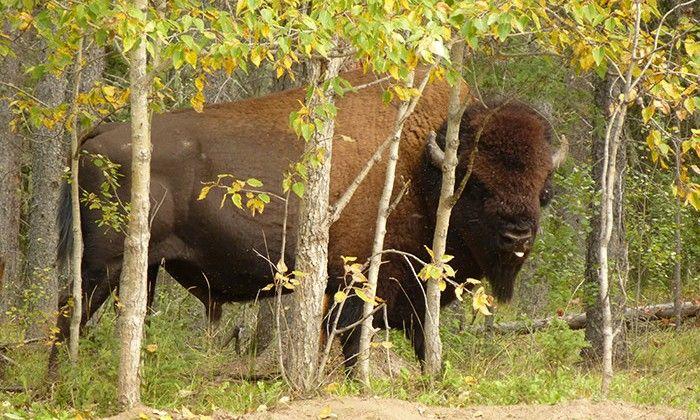
 Some commercial shipping along Hudson Bay here when not frozen over")
 lakes!")
24 Ontario A.k.a. The Nation s Heartland 2nd in size, 1st in population British heritage (sharply contrasting Quebec s) Capital: Toronto Northern Ontario Sparsely populated A narrow strip of swampy lowlands and coastal plains run along Hudson Bay Large portion of area is protected for Polar Bears by Polar Bear Provincial Park (PP) Some commercial shipping along Hudson Bay here when not frozen over Canadian Shield covers half of provinces, mostly in the north Magnificent forest, and 250,000 (quarter million) lakes! Many furry animals furs = $ Ontario is Iroquois for shining waters Leads nation in gold & nickel mining
25 Ontario Canada s Population Centers ~90% of Ontario s population lives south of Canadian Shield on a tiny finger of land between Lake Huron & Lake Ontario Southernmost region in Canada City of Windsor, Canada lies further S than Boston, MA, USA Relatively warm climate, fertile soil and shipping advantages of the Great Lakes Plains make region the center of Canadian industry & population LIFE Very similar to bordering US diary states w/ dairy farms, orchards, veg gardens, grain fields Golden Horseshoe area of industry on the western shore of Lake Ontario's Close proximity to iron mines and ports 19th century growth Leading automobile manufacturing (similar weather to Detroit, MI, USA)
 2nd 1813,")
26 Ontario Toronto Hub of population centers w/ ~9 more large cities, largest metropolitan area Commercial center cities of: Hamilton, London, Windsor Canadian stock exchange Great Lakes Plain Where Toronto lies Last place invaded by foreign troops War of 1812 US launched 2 major invasions 1st in 1812 was driven back by GB & resulted in capture of Detroit and Fort Dearborn (Chicago) 2nd 1813, USA captured Toronto (then York), burned gov t buildings Retaliation for burnings? GB burns White House and major parts of DC in 1814 Demilitarization of region after wars end common border of 49 N to the Rockies Outcomes? Longest peaceful border in the world s history Common sense of Canadian-ship (unification of Canadian)
 and Lower Canada (O) rebelled against GB GB squashed the rebellion & combined the two Canada Granted the right to govern own internal affairs (Perhaps had")
27 Ottawa: The Nation s Capital Like DC, it is a district located in between two provinces (Ontario & Quebec) Sits on the Ottawa River, a tributary of the St. Lawrence River 1837 colonists of Upper (Q) and Lower Canada (O) rebelled against GB GB squashed the rebellion & combined the two Canada Granted the right to govern own internal affairs (Perhaps had they done this with the US colonies, we wouldn t have separated) Union lasted until 1867 when the British North America Act established a confederation (loosely tied together) of four provinces: Ontario, New Brunswick, Quebec, and Nova Scotia Since then 6 more have joined July 1 is Canada Day (except in Quebec)
28 Why not in Quebec? A Canadian citizen from a blog claims: Canada Day is celebrated in Quebec to some degree. Just not as energetically as in most of the rest of the country. June 24 (St-Jean-Baptiste) is the more popular day for sure and where you have the biggest celebrations. It is also referred to as "la fête nationale (du Québec)". It's worth noting that the June 24 celebration has a much longer history than Canada Day (July 1). June 24 is basically the original national holiday in this part of the world. Some people trace back its roots to the first half of the 1600s. It has had its ups and downs since then but has always been celebrated in some way. Canada Day marks the current Canadian political set-up (Confederation) that was agreed upon on July 1, I believe it was marked by ceremonies and other events even in the first part of the 20th century but it only truly became a huge public celebration (in Ottawa and other cities) around the 1970s and 1980s. This coincided with a major resurgence of St-Jean-Baptiste festivities in Quebec, with a nationalist and even separatist angle to them. The Canadian government wanted something to compete with that so they boosted the July 1 holiday significantly, changed the name from the old "Dominion Day" to "Canada Day", and the rest is history. Read more:
 The leader of HoC becomes the Prime Minister PM is similar to the executive branch But is both speaker of the Commons & chief executive Senate is chosen by the PM")
29 Ottawa: The Nation s Capital The Dominion of Canada is modeled after the British Parliamentary system Parliamentary system Elect representatives to the House of Commons Similar to House of Representatives (law-making body) The leader of HoC becomes the Prime Minister PM is similar to the executive branch But is both speaker of the Commons & chief executive Senate is chosen by the PM (all 104) and job is to protect the interest of the provinces (imagine if the POTUS selected all 100 senators?) US Senate is 2nd part of legislative branch Different from US s political system (as noted above) All power essentially resides in the hand of the PM (US is dispersed between the 3 branches) Canada voluntarily chooses to be a part of the British Commonwealth They remain loyal to the monarch (Elizabeth II) She remains the ceremonial head of state, but does not deal in their internal affairs (the monarch must remain apolitical) a governor is appointed to represent her
30 Ottawa: The Nation s Capital Parliamentary System cont. Federal system of gov t Meaning Ottawa share power with the provinces (Provinces rights?) Each province has its own unicameral legislature & a premier (a governor) Mini version of parliament premier is chosen by legislature Constitutional Crisis Never had a civil war, but a fragile union nonetheless French Canadians desire a veto power over anything that might jeopardize their culture SO, Quebec refused to sign/ratify the 1982 Charter of RIghts and Freedoms (equivalent to the Bill of Rights) English & French were made official languages of the nation 1993 saw party changes Major political party wiped out from 153 to 2 seats in parliament lead to 2 new parties Separatist Party (mainly in Quebec) Reform Party (western provinces) against Ottawa s big gov t programs & special treatment Canada has more than 2 major parties, as seen in USA 1995/1996 a referendum was voted on to become a sovereign country, but failed 49.4% to 50.6% Future looks grim still Current PM: Justin Trudeau (Liberal Party essential follows US Democratic Party)


31 Great Circle Routes Distances can be deceptive on maps Special maps are required for flying, especially internationally Requires a globe Here s a airplane capitan to explain it: KzYsb3Bys9Y
32 SRQ Pg Which province has the largest population? Who is the head of state in Canada? Who chooses the prime minister of Canada? How many provinces are in Canada s confederation? To what church do most Canadians belong? Compare and Contrast Quebec s regionalism with the Southern states of the United States.
33 The Western Provinces Common traits shared by the US & Canada continue into the west Vast tracts of land have so few people that they still remain territories today! Trans-Canada Highway is 4,860 miles Links east & west Follows the ribbon development just north of US border Only 2 other nations have more railroads (RR) than Canada Frontier spirit still lives in Canada USA & Russia Many people depend on airplanes for supplies because they re so far forth & isolated Think Alaska for a lot of it

34 The Prairie Provinces The Central Plains of the USA extend north into Canada s heartland Temps in the southern regions are comfortable in the summers But can get hot due to the dryness, and drop very low in the evenings Located in the rainshadow ^see above^ Steel plow revolutionized region s use Remained a frontier for longer than US frontier because of the colder climate Between the Canadian Shield & the Rockies Main immigrants came from: Germany, Poland, Russia Struggled to farm wait til next year became the saying Shared in the Dust Bowl misery of the 1930s (remember a Great Depression in the USA led to a global depression) known as the Dirty Thirties in Canada Seed and irrigation improvements from the Green Revolution have improved Canada s use of the land Breadbasket of Canada Wheat, barley, and global leader in flax Skyscrapers of the prairie are grain elevators that store grain and barley Northern Canadian Shield to the east is mostly empty, but a few indian tribes inhabit the area and eke out a living

35 Manitoba A.k.a. Gateway to the West Capital: Winnipeg Sits on the Red River flows into Lake Winnipeg lakes are found in the center Population: 1.5 million in the whole prov. NC has 10 million ppl... Lake Winnipeg (main water source is from Minnesota!) Lake Manitoba Lake Winnipegosis Métis: descendants of French men & Indian women inhabit here Descended from the coureurs de bois (French Woodsmen) mostly hunting for fur Irish & Scottish came in 1812, but all were attacked and killed by the Métis Red River Rebellion 1867 Métis rebelled after the dominion of Canada established Why? Feared farmers would take their land. To which they had no title forced Canada to grant the locals a bill of rights in 1870 & create the 5th province MANITOBA Prairie found in the easternmost region Produces flax, buckwheat, sunflowers, peas Riding Mountain National Park has wolves, bison, and lynx Canadian Shield covers the majority of MB North swampy lowlands along the Hudson Bay Churchill, MB, is the Polar Bear Capital of the World

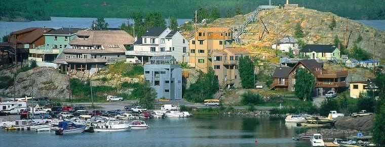
 Worst Parts of MB:")
36 Cigarettes Outlawed? a Things that make MB great: Caribou Maple syrup Lots of lakes Honey Dill Sauce Drinking age: 18 Marijuana legal (but MANY regulations) Worst Parts of MB: They do have mosquitoes! Caterpillar infestations No public transp.


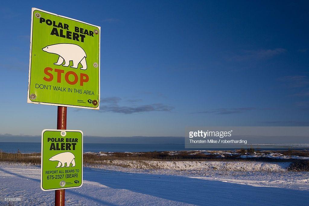
37 How can we protect the Polar Bear Population?
38


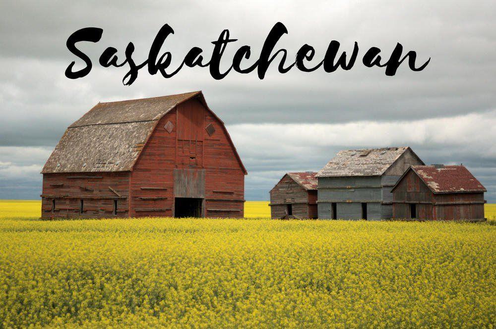
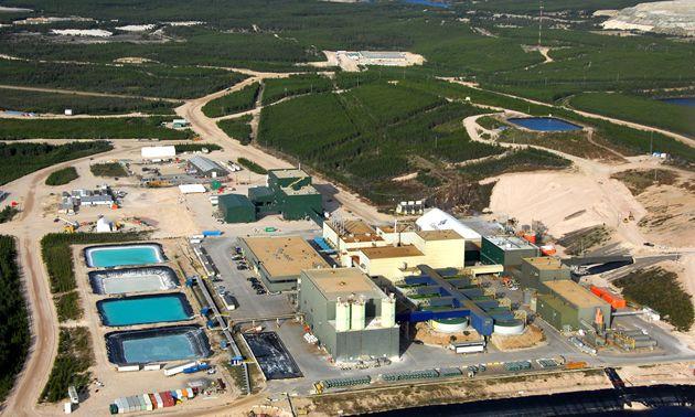
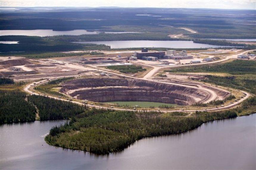
39 Saskatchewan A.k.A. Canada s Breadbasket Capital: Regina Settled by Métis that moved out of MB & established farms along the North Saskatchewan & South Saskatchewan Rivers Saskatchewan Plain, productive extension of the Interior Plain in USA Whites moved west w/ railroads As whites moved in the Métis revolted again & set up their own gov t But Canada fought back this time sent troops & caught Louis Riel, the rebel leader, and hanged him Became a prov. In 1905 Wheat leading producer in Canada & even more than USA states Processed in Regina or Saskatoon Cypress Hills have highest point between Labrador & Canadian Rockies Prince Albert National Park buffalo roam here Wilderness mostly in the north also uranium Taiga & tundra covers this part of Canadian Shield World leader in uranium production
40

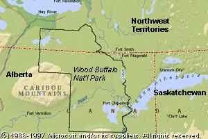
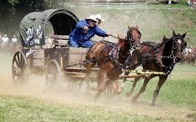
41 Alberta Capital: Edmonton Leader in barley & beef (for Canada) Canadian Shield covers the NE tip Sand dunes, salt plains, boreal forests, gypsum karst formations, river deltas (see pictures) World s largest herd of Wood Buffalo Calgary Region is known for its oil reserves which are said to exceed Saudi Arabia! 1922 Wood Buffalo NP Agricultural center of the prov. A.k.a. The Gateway to the Canadian Rockies 2nd largest city Tourism & petroleum field nearby have spurned growth Calgary Stampede annual rodeo most famous for chuck wagon races Hosted Olympics in 1988 Calgary Zoo has tons of dinosaurs & camels SW border follows continental divide in Canadian Rockies Head-Smashed-In Buffalo Jump Indians hered buffalo over the ridge to kill them & then butchered below aces-you-have-to-visit-i n-alberta-canada/
42

43 Royal Canadian Mounted Police Federal level police force In May 1873, the Parliament of Canada established a central police force, and sent 150 recruits west to Manitoba. The officers established a permanent post at Fort Macleod, Alberta, where approximately half of the Force was posted. The remaining members were either sent to Fort Edmonton or to Fort Pelly, Saskatchewan, which had been designated as headquarters. In 1904, King Edward VII conferred the title of "Royal" upon the North-West Mounted Police. Women were first accepted as uniformed members in The 70s also brought an expansion of responsibilities in areas such as airport policing, VIP security and drug enforcement. TODAY: scope of operations includes organized crime, terrorism, illicit drugs, economic crimes and offences that threaten the integrity of Canada's national borders. Information found at:
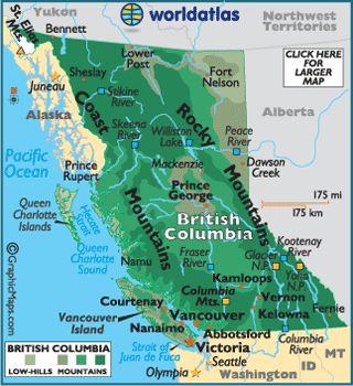
44 Indep.) Main trade fur w/ coastal Indians Americans came in 1788 to explore the Columbia River from the West (Lewis & Clark explored inner continent 1803) Ownership was not agreed between the warring countries Americans went into Oregon after land became GB s War almost broke out again between USA & GB in 1840s over B.C. USA demanded all lands south of N GB wanted lands north of Columbia River Slogan Fifty-Four Forty or Fight British Columbia Capital: Victoria 3rd largest prov. & 3rd most populous & Only prov. In P. NW Rocky Mts & Pacific Ranges cut the prov. Off from the rest of the continent British ships did not see the shores until 1778! (That s 2 years after Dec. Of

45
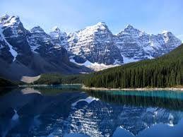
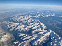
46 Western Cordillera from Southerns USA to Alaska Cordillera: Spanish for Backbone mountain chains Covers most of B.C. Encompasses 1,000-mile wide band of three mountain systems: In Canada the cordillera encompasses 500-mile wide band of 2 mountain systems: Logging Lead mining Tourism National Parks that display pristine mountain beauty: 1. The Rockies 2. Coast Mountains Coast Ranges run into Pacific Ocean in Canada Industries: 1. The Rockies 2. Sierra Nevada & the Cascades 3. Coast Ranges 1. Yoho 2. Kootenay 3. Glacier 4. Mount Revelstoke Highest Peak Mount Robson 12,972 ft Plateau separates the Canadian Rockies from the Coast Mts Coast Mts contain all of the highest peaks in all of Canada Copper mines (2nd only to AZ) British Columbia

47

48 LOTS OF PROTECTED LANDS

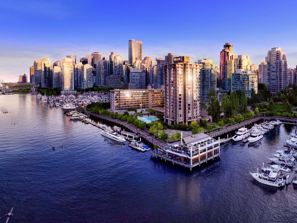
49 British Columbia The Pacific Coast Japan current brings warm waters up into BC marine west coast climate Most pleasant climate in all of Canada Wet winters, generally above freezing Warm summers around 80 F Orchards fill the valleys, salmon fill the rivers Tall dense forests douglas firs, red cedars, hemlock trees Leading producer of lumber (more than any prov. Or US state) Vancouver largest city Located at mouth of Fraser River which empties into Pacific O via Puget Sounds Most fertile soil in province Rapidly grew in 1885 after completion of nations first transcontinental railroad CP RR Canadian Pacific Railway Deep port is busiest in the nation lumber, salmon, minerals, and prairie wheat pass through here Go through USA & Japan

50 All Make UP Japan Current
51
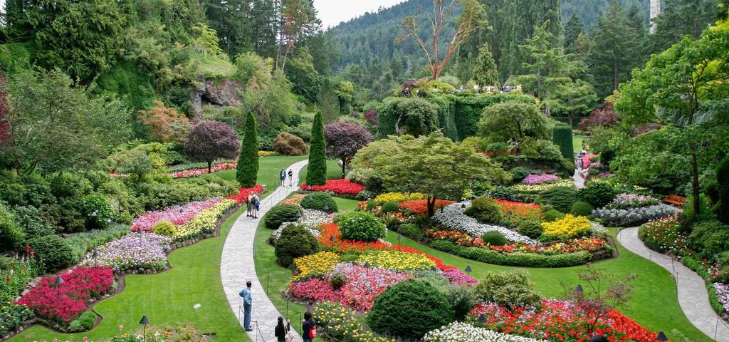
52 Off the coast, a small island chain protects the Inside Passage Victoria Capital Sits across from Vancouver on the southern edge of Vancouver Island One of the few Canadian cities where British traditions have been kept intact Houses & streets appear much like British cities Some speakers still retain a British accent If not on many words Double decker busses & formal gardens Butchart Gardens world famous British Columbia Islands are actually tops of Coast Range from USA Ocean floor has flooded this range it has been called the Insular Mountains It is the largest island off the west coast of the American Continents
53
54 SRQ Pg Name the Prairie Provinces. What is the only province on the Pacific? Define cordillera. Which two provinces contain part of the Western Cordillera? Where is Canada s mildest climate? Why is it so mild? Name a product of and a national park in each Western Province. What are Canada s Coastal Mountains called after the enter the United State? Why does the name change?
55 Canada s Territories Over 40% of Canada s land is located in its Northern Territories But all combined they have the fewest people WHY? IT S COLD! Only a few Eskimos, Indians and European Canadians brave the cold. Work: Reservations, trading posts, mines, and military installations Native Peoples: Inuit means real men but a.k.a. Eskimos mean eaters of raw meat Eat whales, seals, walruses, caribou Traded blankets, knives, guns and other goods for furs and skins Trade led to establish friendly relations 300,000 Indians today Still live traditional lives but hold regular jobs via the military or mining Rifles have replaced harpoons for hunting Snowmobiles & dog sleds Bones crafts are popular trinkets Dwindling population 25,000 All Native Americans in both Canada & USA are prone to alcohol abuse So you may hear about alcoholics are more in these gene pools


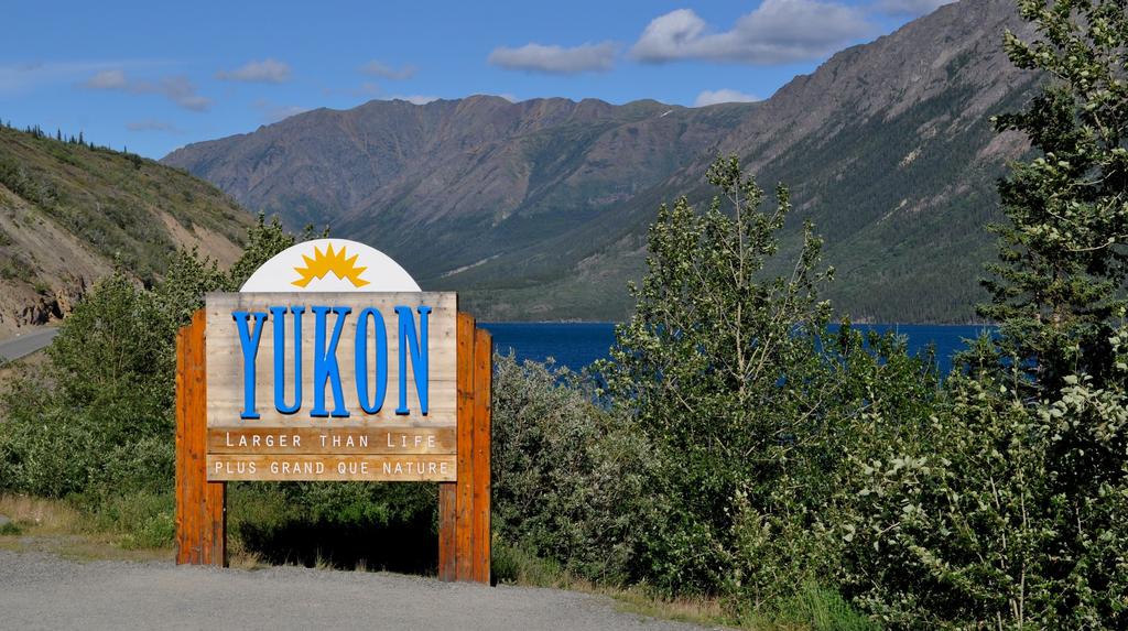
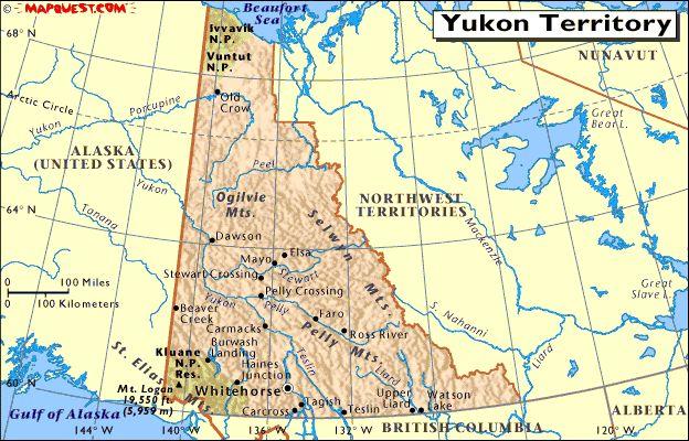
56 Yukon Territory Yukon Cornelius! Capital: Whitehorse North of BC, larger than CA Gold brought thousands of miners to the Klondike region in 1890s Alaskan Highway Lead & zinc surpass gold now leader Al-Can (Alaskan-Canadian Highway) Winds through the mountains to connect Dawson Creek, BC to Anchorage, AK 1st used by US Army during WW2 for supplies Same geographic regions as AK Narrow central valley lies along Yukon River Established Whitehorse here only real city between Dawson & Anchorage Mount Logan (Canada s highest mountain) 19,524ft Wolverine? (j/k)


57

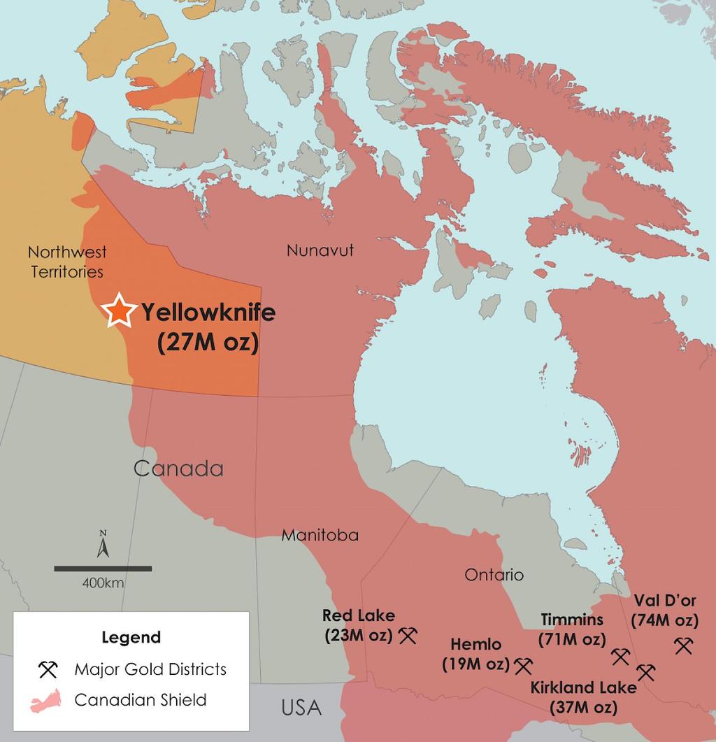
58 Northwest Territory 2nd largest ter Capital: Yellowknife ⅕ of the population lives in Yellowknife Located near Great Slave Lake (deepest lake in North America) Great Bear Lake largest lake by space entirely inside Canada Mackenzie River longest river system in North America Winds north from the Great Slave Lake into western part of the territory, and empties into Arctic Ocean Named for: Sir Alexander Mackenzie a trapper who first explored the river in 1789 (same year as US Const.) Most NWT settlements are scattered among this river as winds through the territory Note: settlements NOT cities very tiny Oil has been found in the delta (delta is mostly frozen) Evergreen forests are found near the river, but most of the land lies above the timber line (where trees don t grow) Major Industries: Mining for lead & zinc Trapping (fur) Fishing Diamonds (discovered in 1991 biggest mineral rush in Canadian history) near Lac de Gras


59 Named for the Slavey Indians not actual slaves


60 Northwest Territory Just off the continent but still in the territory is an archipelago (islands grouped together) a.k.a. Arctic Islands 9 exceed 10,000 sq miles Southern islands are flat Northern islands are mountainous Barbeau Peak located on Ellesmere Islands 8,582 ft highest peak of islands Sit above the Arctic Circle Mostly uninhabited Barren, covered in snow all year Polar, tundra climate -30 F or lower in the winter Summer, barely reaches above 50 F Permafrost keeps large plants from growing Some small bushes and grasses can grow for about 2 months

61

62 The archipelago Shard w/ Nunavut


63 Nunavut Split from the Northwest Territory in approved in 1992 to create Nunavut ~20% of Canada Split finalized in 1999 Gave the Inuit the power to self-govern Nunavut: our land in Inuit Includes most of the old territory except ARctic Islands and Mackenzie River valley Only 28 villages in the whole expanse of this territory Baffin Island, largest of the Canadian Archipelago Iqaluit is located here Thousands of glaciers creeping off the island
 Vikings!")

![So [ ] you have to consider the possibility that as remote as it may seem, these finds](/docs-images/87/96756707/images/64-2.jpg "may represent evidence of contact with Europeans prior to the Vikings' arrival in")

64 Nunavut Some archaeological evidence as recently as 2008: Found caucasian bones (not Inuit) Vikings! "Dating of some yarn and other artifacts, presumed to be left by Vikings on Baffin Island, have produced an age that predates the Vikings by several hundred years. So [ ] you have to consider the possibility that as remote as it may seem, these finds may represent evidence of contact with Europeans prior to the Vikings' arrival in Greenland." (Jane George, "Kimmirut site suggests early European contact: Hare fur yarn, wooden tally sticks may mean visitors arrived 1,000 years ago", Nunatsiaq News, September 12, Retrieved October 5, 2009) Very restrictive laws on Alcohol Easier to obtain arms
65 SRQ Pg Distinguish the two native peoples of Canada. What industry mutually benefited the Europeans and the native peoples? What two ranges extend through British Columbia to Alaska? Where is CAnada s highest mountain? Where are the most settlements in the Northwest Territory? Why did many Canadians oppose the creation of Nunavut?

66 END CHAPTER 10 CANADA
Human Geography of Canada
 Human Geography of Canada History and Government of Canada Like the United States, people migrated across Beringia into Canada, these people were the ancestors of the Inuit (Eskimos) 16 th and 17 th centuries,
B is for British Columbia. A is For Alberta
 C is for Canada A is For Alberta Alberta is one of the only provinces in Canada with 2 NHL teams. Edmonton, the capital of Alberta is the home of the West Edmonton Mall, which is the largest shopping mall
Geography: Unit 2. Map. Rivers. Major Physical Features. Slide 1. Slide 2. Slide 3. Slide 4. North America United States and Canada.
 Mississippi River Slide 1 Slide 2 Slide 3 Slide 4 Geography: Unit 2 North America United States Map Major Physical Features Mountain Ranges Brooks Range Mackenzie Mountains Coast Mountains Cascades Sierra
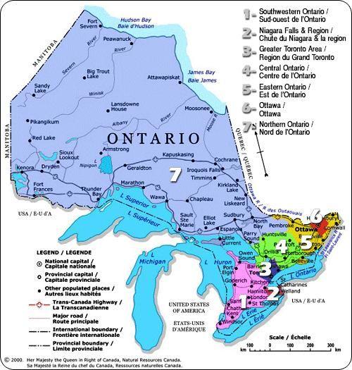
Canada s Regions. The Regions of Canada. Provinces and Territories. Population. The National Capital. Central Canada
 44 Your Canadian Citizenship Study Guide Canada s Regions Canada is the second largest country on earth 10 million square kilometres. Three oceans line Canada s frontiers: the Pacific Ocean in the west,
Match the names below with their locations on the map by writing the correct letter in the blank.
 P r e v i e w Match the names below with their locations on the map by writing the correct letter in the blank. Physical Features of Canada 60ºN 70ºN 80ºN A R C T I C O C E A N 130ºW 120ºW 110ºW 90ºW 70ºW
STEP 1: Label the following provinces and territories on the lines provided. Be sure to label your map NEATLY.
 CGC 1P Map of Canada STEP 1: Label the following provinces and territories on the lines provided. Be sure to label your map NEATLY. Label the following provinces and territories in BLOCK LETTERS: Alberta
Geography: Unit 2. Map. Major Physical Features. Rivers. Mississippi River Missouri River Ohio River Rio Grande. Mackenzie. Colorado River Green River
 1 2 3 4 Geography: Unit 2 North America United States and Canada Map Major Physical Features Mountain Ranges Brooks Range Mackenzie Mountains Coast Mountains Cascades Sierra Nevada Rocky Mountains Appalachian
The Settlement of A New Land : Canada
 The Settlement of A New Land : Canada Part One : 1600-1713 DIVITO 2018 In the beginning: After the discovery of the great fishing along the coast of the Atlantic Provinces, fertile land along the St. Lawrence,
^-.^.^TK'^^.?' ".. Information and Exercises. about. The Territories. Yukon Territory Northwest Territories. Nunavut Territory.
 ^-.^.^TK'^^.?' ".. Information and Exercises about The Territories Yukon Territory Northwest Territories Nunavut Territory Whitehorse, Yukon fyukon TERRITORY ] Key Words: taiga- northern forest area boreal-
CANADA: ITS LAND, RESOURCES, & ECONOMY PRE-TEST
 PRE-TEST Name Directions: In the blank space, write a "T" if the statement is true and an "F" if the statement is false. 1. Canada has 11 geographic regions. 2. The cordillera is found in central Canada.
Name: Crossword: Canada ACROSS. 5. The bilingual province. 6. The only French province. 10. It's capital city is Winnipeg. 12. Capital of Canada.
 Name: Crossword: Canada ACROSS 5. The bilingual province. 6. The only French province. 10. It's capital city is Winnipeg. 12. Capital of Canada. 14. Northern territory with many mountains. 15. Capital
Název školy Gymnázium, Šternberk, Horní nám. 5 Číslo projektu CZ.1.07/1.4.00/
 Název školy Gymnázium, Šternberk, Horní nám. 5 Číslo projektu CZ.1.07/1.4.00/21.0390 0218 Šablona Označení materiálu III/2 Inovace a zkvalitnění výuky prostřednictvím ICT VY_32_INOVACE_HoP08 Vypracoval(a),
Exploring Canada. Have you ever travelled to another part of Canada? How did you. More About... A Big Country CHAPTER 1
 CHAPTER 1 Exploring Canada Have you ever travelled to another part of Canada? How did you get there? Can you imagine travelling there in a wheelchair? Rick Hansen travelled through all ten of Canada s
STEEL RIBBON OF MAKING TRACKS FEATURE STORY. The railway helped to make Canada a country, but along the way there were winners and losers, shady
 FEATURE STORY RIBBON OF STEEL The railway helped to make Canada a country, but along the way there were winners and losers, shady deals and amazing achievements The first true railway in Canada was the
Canada. Canada A Reading A Z Level J Leveled Book Word Count: 294 LEVELED BOOK J
 Canada A Reading A Z Level J Leveled Book Word Count: 294 LEVELED BOOK J Connections Writing Write a paragraph telling why you think Canadians celebrate winter. Include facts about how they celebrate winter
THE USA. The capital of USA is Washington D.C., in the District of Columbia.
 THE USA The United States of America is the richest and one of the biggest countries in the world. It has a population of about 295 million people. It is divided into 50 states; two of them, Alaska and
Canada Print Article World Book Advanced
 Page 1 of 7 Back Print this page Canada The land Map Canada provinces Canada covers most of the northern half of North America. It borders Alaska on the northwest and the rest of the continental United
Location, Climate, & Natural Resources Brain Wrinkles
 Location, Climate, & Natural Resources Standards SS6G10 The student will explain the impact of location, climate, natural resources, and population distribution on Europe. a. Compare how the location,
Location, Climate, & Natural Resources
 Location, Climate, & Natural Resources UK is a country of islands off the coast of mainland Europe. It consists of England, Northern Ireland, Scotland, & Wales. UK s location makes it a HUB for trade.
Physical Regions of the U.S.
 Physical Regions of the U.S. Quickly use this map to label the map on your paper Pacific Coast The coast from southern California to Alaska The region of the Pacific Northwest has a long history that was
Canada. Canada A Reading A Z Level J Leveled Book Word Count: 294 LEVELED BOOK J
 Canada A Reading A Z Level J Leveled Book Word Count: 294 LEVELED BOOK J Connections Writing Write a paragraph telling why you think Canadians celebrate winter. Include facts about how they celebrate winter
The Land Photo Source: The Atlas of Canada, The Red River, Manatoba, Canada land/physio_red_ri
 The Land The United States and Canada An Overview of the Region The United States and Canada are the two largest countries in North America. The Rio Grande is part of the southwest border of the United
Label your Map with Russia. Map Activity
 Bell Activity How many time zones does the U.S. have? How do these time zones affect life in the U.S.? Russia is so large it has 11 time zones. What difficulties might this create? Objectives Know landforms,
2. The most important crop in Mexico. 3. The Priest who spoke against Spain. 5. Ancient Aztec city, now Mexico City
 Name: Date: Did you hear about what happened at the laundromat last night? Three clothespins held up two shirts! Clues are listed below. Print the word that matches the clue on the blank line by the clue.
The Geological Pacific Northwest. Wednesday February 6, 2012 Pacific Northwest History Mr. Rice
 The Geological Pacific Northwest Wednesday February 6, 2012 Pacific Northwest History Mr. Rice 1 Free Response #2 Please do not simply list the items for this response. Full sentences!!! Minimum of 3-5
Level 2 Intermediate. Cool in Canada 1 WARMER. Work in pairs and write ten things that you associate with Canada into the maple leaf.
 1 WARMER Work in pairs and write ten things that you associate with Canada into the maple leaf. 2 WHAT DOES IT MEAN? Write the words from the article into the gaps. The paragraph numbers are given to help
Geography Unit: North America Section: Physical Characteristics and Systems of North America. Tutorial: Regions of North America
 Geography Unit: North America Section: Physical Characteristics and Systems of North America Tutorial: Regions of North America Regions of North America Welcome to the tutorial about the regions of North
CANADA BASIC INFORMATION GEOGRAPHY. Official name. Canada Population. over 32 million Total area. 9,976,140 sq km Capital. Ottawa Form of government
 CANADA BASIC INFORMATION Official name Canada Population over 32 million Total area 9,976,140 sq km Capital Ottawa Form of government Federal parliamentary state Head of state and government Prime Minister
4th Grade Third 9 Weeks Test
 4th Grade Third 9 Weeks Test Multiple Choice Identify the choice that best completes the statement or answers the question. 1 A waterway for ships that is dug across land is called a. A port C river B
BREAKFAST CLUB OF CANADA
 BREAKFAST CLUB OF CANADA QUEBEC IN NUMBERS 283 CLUBS 17,162 DAILY ATTENDANCE 2,831,730 BREAKFASTS SERVED PER YEAR 48 CLUBS ON WAITING LIST More than 1,000 QUEBEC SCHOOLS ranked between 8 and 10 could receive
Level 3 Advanced. Cool in Canada 1 WARMER. Work in pairs and write ten things that you associate with Canada into the maple leaf.
 1 WARMER Work in pairs and write ten things that you associate with Canada into the maple leaf. 2 WHAT DOES IT MEAN? Skim-read the article to find the words that fit in the gaps. The paragraph number is
Latin America and The Caribbean. A Closer Look.
 Latin America and The Caribbean A Closer Look. Mexico Capital: Mexico City The Location of Mexico Mexico is the second-largest country by size and population in Latin America.but the Largest Spanish -
13 DAYS. Atlantic Maritimes Tour
 A comprehensive tour of the Maritime Provinces including Nova Scotia, New Brunswick and Prince Edward Island. Discover magnificent coastlines, maritime wonders and east coast energy. Experience the Maritimes
A Canadian KWL. Date: What I Want to Know About Canada. What I Have Learned About Canada. What I Know About Canada. Name:
 Canadian Geography Date: Name: A Canadian KWL 1 What I Know About Canada What I Want to Know About Canada What I Have Learned About Canada 0 Portage & Main Press 2043_ May be reproduced for elaa&oo : use.
Economy 3. This region s economy was based on agriculture. 4. This region produced items such as textiles, iron, and ships in great quantities. For th
 Geography 1. This region has a climate of warm summers and snowy cold winters. 2. This region has a climate that is generally warm and sunny, with long, hot, humid summers, and mild winters, and heavy
CH. 1 Europe and Russia: Physical Geography. Section 1 Land and Water p Europe and Russia are part of the world s largest landmass called.
 CH. 1 Europe and Russia: Physical Geography Section 1 Land and Water p.10-16 Europe and Russia are part of the world s largest landmass called. The country of Russia stretches over both continents. About
Hudson Bay Lowlands Proposed Protected Areas
 Hudson Bay Lowlands Proposed Protected Areas Hudson Bay Lowlands Proposed Protected Areas The Protected Areas Initiative has identified portions of the Hudson Bay Lowlands region that have significant
Chapter 2A: The Russian Realm
 Geography: Realms, Regions, and Concepts 16 th Edition Chapter 2A: The Russian Realm The Russian Realm Two transition zones mark the margins. The Russian Realm Two transition zones mark the margins. Physical
Canada s National Core
 Regional Landscape Studies Regional Landscapes of the United States and Canada Canada s National Core Prof. Anthony Grande AFG 2016 NORTHLANDS NORTHEAST COAST MEGALOPOLIS CANADA S NAT L CORE AMERICA S
Report of Protected Area in Canada
 Report of Protected Area in Canada Current as of December 31, 2017 NATIONAL Terrestrial Marine protected areas Canada (All provinces and territories) 105,315,093 44,292,638 8,123 % of Biome Protected 10.55%
Shaping of North America. Physical Geography II of the United States and Canada. The Last Ice Age. The Ice Age. Pleistocene Polar Ice Cap 2/14/2013
 Physical Geography II of the United States and Canada Prof. Anthony Grande AFG 2012 Shaping of North America The chief shaper of the landscape of North America is and has been running water. Glaciation
Physical Geography of Europe. Chapters 13-18
 Physical Geography of Europe Chapters 13-18 The British Isles Archipelago made of 6000+ small islands Temperate climate Largest body of fresh water is Loch Ness Mostly rolling hills and large flat lands
Natural regions of Alberta
 Natural regions of Alberta Alberta is a big province. It has 6 natural regions. Can you find the regions on the map? Use the legend. Canadian Shield region W This map shows northeastern Alberta. Can you
Just how big is Africa?
 The United States China India The United Kingdom Portugal Spain France Belgium Germany The Netherlands Switzerland Italy Eastern Europe Japan 11.7 million sq. miles Just how big is Africa? Chapter 18 Section
Chapter 7 Geography and the Early Settlement of Egypt, Kush, and Canaan
 Chapter 7 Geography and the Early Settlement of Egypt, Kush, and Canaan How did geography affect early settlement in Egypt, Kush, and Canaan? Section 7.1 - Introduction RF/NASA//Corbis This satellite photograph
Oceania. Australia, New Zealand, and the Pacific Islands. Physical Geography. Where is Australia located?
 Oceania Australia, New Zealand, and the Pacific Islands Physical Geography Australia New Zealand Oceania Where is Australia located? Australia & Oceania are a group of islands located between Asia, Antarctica,
FARM TOUR TO CANADA. Including The Calgary Stampede 27 TH JUNE - 9 TH JULY Optional Extension 8 th - 18 th July Calgary to Montreal
 FARM TOUR TO CANADA Including The Calgary Stampede 27 TH JUNE - 9 TH JULY 2018 Optional Extension 8 th - 18 th July 2018 - Calgary to Montreal The tour starts on Vancouver Island and Victoria, before transferring
Victoria International Airport Your Gateway to the World
 Victoria International Airport Your Gateway to the World Not for profit corporation Incorporated under Part II of Canada Corporation Act Revenue invested in airport 60 year lease with option for 20 more
GEOGRAPHY AND HISTORY
 GEOGRAPHY AND HISTORY YEAR 1, PART 1 www.vicensvives.es Contents 01 Our planet Earth 02 The representation of the Earth: maps 03 The Earth s relief 04 Rivers and seas 05 Weather and climate 06 Climates
"THE STATE OF QUALITY MEASURES IN CANADA KATHLEEN FLANAGAN
 "THE STATE OF QUALITY MEASURES IN CANADA KATHLEEN FLANAGAN October 10, 2013 OVERVIEW Context ECEC in Canada Who uses quality measurement tools? How are they used? Unique examples Governance: Shift to
ESLBO Rock Band Tour Across Canada!
 ESLBO Rock Band Tour Across Canada! are stopping in to play for the night. Congratulations! Your Rock Band has just been offered a chance to record an album with CanStar Records, and will be touring across
Maggie s Weekly Activity Pack!
 Maggie s Weekly Activity Pack! Name Date Remembering A Great Adventure The Journey of Lewis and Clark It has been two hundred years since Lewis and Clark started their journey across America. In February
Curriculum Pacing Guide Grade/Course 5 Th Grade Geography Grading Period 1 st Nine Weeks
 2013-2014 Curriculum Pacing Guide Grade/Course 5 Th Grade Grading Period 1 st Nine Weeks Time Frame Unit/ photographs, pictures, and tables to Locate and identify: Continents and Oceans -North America
Chapter 14. The Physical Geography of Russia
 Chapter 14 The Physical Geography of Russia Chapter Objectives Identify the physical features and natural resources of Russia. Discuss the effects of Russia s climate and vegetation on life in the region.
LOCATION, CLIMATE, AND NATURAL RESOURCES OF MEXICO
 SS6G3 The student will explain the impact of location, climate, distribution of natural resources, and population distribution on Latin America and the Caribbean. a. Compare how the location, climate,
Revised: February 2017 Page 1
 FEDERAL GOVERNMENT ENTERPRISES NAME OF ENTERPRISES: Atomic Energy of Canada Limited Belledune Port Authority Business Development Canada Development Investment Corporation Canada GEN Investment Corporation
THE REGION LAKE SUPERIOR THE GITCHI-GAMI TRAIL & THE NORTH SHORE
 LAKE SUPERIOR THE GITCHI-GAMI TRAIL & THE NORTH SHORE 7 LAKE SUPERIOR: Water covers 70% of the earth s surface area, but only 3% of it is freshwater. Saltwater makes up 97% of the earth s water supply.
STUDY GUIDE. The Land. Physical Features of Latin America. Chapter 8, Section 1. Terms to Know DRAWING FROM EXPERIENCE ORGANIZING YOUR THOUGHTS
 For use with textbook pages 193 198. The Land Terms to Know cordillera A mountain range that runs parallel to another mountain range (page 194) altiplano A high plain (page 194) escarpment A steep cliff
Chapter 20. The Physical Geography of Africa South of the Sahara
 Chapter 20 The Physical Geography of Africa South of the Sahara Chapter Objectives Identify the major landforms, water systems, and natural resources of Africa south of the Sahara. Describe the relationship
Chapter 7. Geography and the Early Settlement of Egypt, Kush, and Canaan
 Chapter 7 Geography and the Early Settlement of Egypt, Kush, and Canaan Chapter 7 Geography and the Early Settlement of Egypt, Kush, and Canaan How did geography affect early in Egypt Kush, and Canaan?
Canada: Its Land, Resources & Economy
 Canada: Its Land, Resources & Economy from Our North American Neighbors Series Produced by Colman Communications Teacher s Guide written by Barri Golbus This video is the exclusive property of the copyright
Touring Eastern Canada: Driving Holidays And Rail Journeys In Ontario, Quebec, And The Atlantic Provinces (Thomas Cook Touring Guides) By Cook
 By Cook") Touring Eastern Canada: Driving Holidays And Rail Journeys In Ontario, Quebec, And The Atlantic Provinces (Thomas Cook Touring Guides) By Cook If searching for a book Touring Eastern Canada: Driving Holidays
Touring Eastern Canada: Driving Holidays And Rail Journeys In Ontario, Quebec, And The Atlantic Provinces (Thomas Cook Touring Guides) By Cook If searching for a book Touring Eastern Canada: Driving Holidays
Welcome to the Midwest!
 Welcome to the Midwest! Why do we call the Midwest "America's Heartland"? 5 9 7 4 2 Farm State 6 8 1 St. Louis 3 St. Louis, Missouri "Gateway to the West" Frontier: the beginning of unexplored land Pioneers:
15 DAYS. Wildlife of the Maritimes
 The mix of rugged coastlines, sandy beaches, marshlands, mixed forests and fresh water lakes provide a wide range of habitats for a variety of wildlife. On this tour you need to keep your eyes open for
FARM TOUR TO CANADA. Including The Calgary Stampede 26 TH JUNE - 7 TH JULY Optional Extension 7 th - 16 th July Calgary to Montreal
 FARM TOUR TO CANADA Including The Calgary Stampede 26 TH JUNE - 7 TH JULY 2019 Optional Extension 7 th - 16 th July 2019 - Calgary to Montreal The main tour starts on Vancouver Island and Victoria, before
An Update of Rituals in Canadian Jurisdictions by WBro John E. Taylor
 Sunday Masonic Paper No. 842 An Update of Rituals in Canadian Jurisdictions by WBro John E. Taylor Additions and corrections are from: Freemasonry through Six Centuries by Bro. Henry Wilson Coil Sr. Coils
Tourism Snapshot. June 2015 Volume 11, Issue 6. A focus on the markets in which Destination Canada (DC) and its partners are active.
 and its partners are active.") Tourism Snapshot Tourism PEI / Paul Baglole A focus on the markets in which Destination Canada (DC) and its partners are active. www.destinationcanada.com June Volume 11, Issue 6 Key highlights Over the
Tourism Snapshot Tourism PEI / Paul Baglole A focus on the markets in which Destination Canada (DC) and its partners are active. www.destinationcanada.com June Volume 11, Issue 6 Key highlights Over the
Exam Review. Part 3- Deserts, Glaciers, and maps
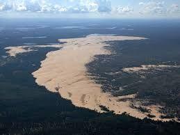
 Exam Review Part 3- Deserts, Glaciers, and maps What causes a desert? Lots of sand Vegetation holds the arms Star Dunes- Star dunes form only in places where wind blows from varied directions over the
The French Period
 The French Period 1500-1763 The Beginning On June 29 th 1534 Jacques Cartier arrived on the Island. He explored for two days from Malpeque to Tignish. Cartier commented on the lack of good harbors. Cartier
Exam Review. Part 3- Deserts, Glaciers, and maps
 Exam Review Part 3- Deserts, Glaciers, and maps What causes a desert? Lots of sand Vegetation holds the arms Star Dunes- Star dunes form only in places where wind blows from varied directions over the
SS8G1 The student will describe Georgia with regard to physical features and location.
 SS8G1ab Standards SS8G1 The student will describe Georgia with regard to physical features and location. a. Locate Georgia in relation to the region, nation, continent, and hemispheres. b. Describe the
SEDI Contact Information
 SEDI Contact Information For technical problems relating to: resetting your password resetting your Access Key error messages For registration questions such as: how to register how to activate registration
ADVENTURE IS A TRAIN RIDE AWAY. We can get you there. The rest is up to you.
 ADVENTURE IS A TRAIN RIDE AWAY We can get you there. The rest is up to you. CANADA BY RAIL / VIA RAIL CANADA CANADA BY RAIL / VIA RAIL CANADA WHERE WILL YOU GO NEXT? VIA Rail s 40th anniversary is the
Eastern Canada Explorer Highlights - 16 days, 35 hrs, 3400 nm
 Eastern Canada Explorer Highlights - 16 days, 35 hrs, 3400 nm This tour brings you many Canadian icons: Niagara Falls, the lakes and forests of the Canadian Shield, and the UNESCO site of Old Quebec City,
Mexico. Chapter 10. Chapter 10, Section
 Chapter 10, Section World Geography Chapter 10 Mexico Copyright 2003 by Pearson Education, Inc., publishing as Prentice Hall, Upper Saddle River, NJ. All rights reserved. Chapter 10, Section World Geography
Lesson 1: Land and Climate of the West Land and Water of the West 1. There are 13 states in the West, divided into 3 regions a. Southwest: Nevada,
 Lesson 1: Land and Climate of the West Land and Water of the West 1. There are 13 states in the West, divided into 3 regions a. Southwest: Nevada, Utah, Arizona, New Mexico b. Mountain States: Wyoming,
Introduction to Africa
 Introduction to Africa Did you know? Africa has more countries than any other continent. The Sahara is a desert that is the size of the U.S. It s the world's largest desert. Most of the world s gold and
NOVA SCOTIA CANADIAN MARITIME ADVENTURE YOUR NAME HERE September 17 25, 2017
 NOVA SCOTIA CANADIAN MARITIME ADVENTURE YOUR NAME HERE September 17 25, 2017 Sept. 17 - Travel to Portland where we board the afternoon ferry to Yarmouth, NS. We ll arrive in the evening and check into
MEEK tart'
 MEEK tart' Post Card Nebraska is one of the nation's leading stock raising areas. It is famous for dairy products. Corn, grain, hay and sugar beets grow in abundance. Industrial activity has rapidly developed.
Nova Scotia and Prince Edward Island 10 Days from $1395
 1 800 422 3727 Nova Scotia and Prince Edward Island 10 Days from $1395 Itinerary Day 1 Halifax, Nova Scotia Welcome to Canada s Atlantic Coast and the Canadian Maritimes, a land blessed with stunning natural
18 day Unforgettable Rocky Mountaineer and Alaska Cruise
 18 day Unforgettable Rocky Mountaineer and Alaska Cruise International airfares Arrival shuttle All station and port transfers 9 days touring the Rocky Mountains Includes 2 days on-board the famous Rocky
Fort Carillon/Ticonderoga
 Fort Carillon/Ticonderoga A P H O T O G R A P H I C H I S T O R Y B E H I N D T H E S T R A T E G I C K E Y T O B O T H B R I T I S H A N D A M E R I C A N V I C T O R I E S I N T H E N O R T H. S E V
4th Grade Social Studies 2nd Nine Weeks Test
 4th Grade Social Studies 2nd Nine Weeks Test Multiple Choice Identify the choice that best completes the statement or answers the question. 1 Which is the largest city in the United States? A Philadelphia,
Land Distribution. Land Purchases. 14 The Nature of Settlement: Post-Revolution to the Civil War Changing Shape of New York
 14 The Nature of Settlement: Post-Revolution to the Civil War 1780-1865 Prof. Anthony Grande Geography Dept. Hunter College-CUNY Spring 2018 Settlement Sequence: State of New York Revolutionary War ends
Junior Atlas of Canada and the World
 A RCOMMNDD RSOURC FOR GRADS 2 4 CANADIAN PRIMARY ATLAS AND MAPSKILLS WORKBOOK ST Junior Atlas of Canada and the World This colourful atlas from Pacific dge Publishing provides primary children with simplified
2015 Brain Wrinkles. SS8G1b
 SS8G1b Georgia is a geographically diverse state that is divided into five regions. The first three regions (Appalachian Plateau, Valley and Ridge, and Blue Ridge) are in the mountains and foothills of
njt Iow Your personalised ebrochure call Not Just Travel Isle of Wight direct on: created: 17 February 2015
 njt Iow Your personalised ebrochure created: 17 February 2015 call Not Just Travel Isle of Wight direct on: 01983716727 14 Day Holiday Departing May 2015 through to June 2016 Prices from 1699 pp Explore
Chapter 7: The Geography and Settlement of Egypt, Kush, and Canaan
 Chapter 7: The Geography and Settlement of Egypt, Kush, and Canaan Learning Target: I can explain how geography affected early settlement in Egypt, Kush, and Canaan. Ancient Egypt and the Middle East Can
Chapter 11 Study Guide Western Europe
 Chapter 11 Study Guide Western Europe I. Northern Europe: Consists of and A. United Kingdom (Constitutional Monarchy and has political divisions) *, and make up the island known as Great Britain, while
ORANGE JULEP WORLD'S LARGEST DINOSAUR PLANET S LARGEST LOBSTER MAC THE MOOSE
 1. This roadside attraction and fast food restaurant is situated in Montreal, Quebec, Canada. The building is in the shape of a giant fruit, three stories high with a diameter of forty feet. It continues
Figure 8: Treaty 4 Adhesion-Original Moose Mountain Reserves
 the year before gave their adhesion to the Treaty. Those signing included: Wah-peemakwa; The White Bear; Okanes; Payepot; Le Coup de Pheasant (Pheasant Rump); and Kitchi-kah-me-win (Ocean Man). Although
Canadian Geographic Area Code Relief History
 Canadian Geographic Area Code History Province / Territory Method / Event 1947 416 613 418 514 Québec Québec First Area Codes implemented in NANP area 902 Brunswick, Nova Scotia, Prince Edward Island and
Tourism Snapshot A Monthly Monitor of the Performance of Canada s Tourism Industry
 Tourism Snapshot A Monthly Monitor of the Performance of Canada s Tourism Industry February Volume 14, Issue 1 www.destinationcanada.com Tourism Snapshot February 1 KEY HIGHLIGHTS After a slow start in
Countries Of The World: France
 Countries Of The World: France By National Geographic Kids, adapted by Newsela staff on 03.26.18 Word Count 681 Level 780L Image 1: A view of the Eiffel Tower in Paris, France. Paris, or, "the city of lights,"
area sq. km capital - Camberra situated on the southern hemisphere, surrounded by the Indian and Pacific ocean
 Otázka: Australia and New Zealand Jazyk: Angličtina Přidal(a): Petra The commonwealth of Australia area 7 700 000 sq. km capital - Camberra situated on the southern hemisphere, surrounded by the Indian
ENGLISH COLONIES CHAPTER 3
 ENGLISH COLONIES CHAPTER 3 NEW ENGLAND COLONIES Colonies MA PLYMOUTH, MA BAY, NH, CT, RI Climate/Geography bitterly cold winters and mild summers; SHORT GROWING SEASONS! Land was flat close to the coastline
SOL VS.2a, 2b, 2c, 10b
 What are the characteristics of the Coastal Plain? 1. Also known as Tidewater 2. Located near the Atlantic Ocean and the Chesapeake Bay 3. Includes the Eastern Shore, a peninsula between the Atlantic Ocean
Inuit Adventure: Narwhals & other Wildlife of Baffin Island
 Inuit Adventure: Narwhals & other Wildlife of Baffin Island Naturetrek Tour Itinerary 2013 Outline itinerary Day 1 Arrive Ottawa. Day 2 Fly Pond Inlet. Day 3 Travel to the floe edge. Day 4/8 Explore the
The Age of European Expansion
 The Age of European Expansion 1580-1760 Spanish and Portuguese America 1581-1640 1. The Viceroyalty of New Spain was first established in 1535 by King Charles I 1 2. The 15 Captaincies of Brazil were first
HON. J. ROBERT HOWIE FONDS MG32 B45. Finding Aid Number 1863
 -ii- HON. J. ROBERT HOWIE FONDS MG32 B45 Finding Aid Number 1863 TABLE OF CONTENTS 1. Introduction to Fonds 2. Finding Aid. File Classification List. -Volumes 1 to 8. Series: Minister of State for Transport