Exam Review. Part 3- Deserts, Glaciers, and maps
|
|
|
- Russell Flynn
- 5 years ago
- Views:
Transcription
1 Exam Review Part 3- Deserts, Glaciers, and maps

2 What causes a desert?

3 Lots of sand Vegetation holds the arms

4 Star Dunes- Star dunes form only in places where wind blows from varied directions over the course of a year. Star dunes have three or more arms, formed from multiple wind directions.
5
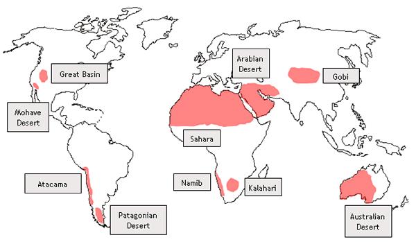
6 The Sahara - The biggest desert in the world The Nile is the only river that carries water all year long. The desert reaches from the Atlantic Ocean in the west to the Red Sea in the east There are about 90 bigger oases in the Sahara desert, where water comes up from underground rivers or wells. People here live in small villages and grow crops. The Sahara also has important raw materials. Oil and gas lie under the Algerian and Libyan desert. There are also other minerals, like copper and iron ore. The Sahara was not always a desert. During the Ice Age, when many parts of the world were covered with snow and ice, northern Africa had a much wetter climate. In desert oases people can live the whole year. They grow dates, wheat and other crops. But, they must also fight against sand storms and wandering dunes that threaten to cover the oases with sand.
7 Light breezes can carry the smallest particle= DUST Only strong winds can carry sand particles Moderate winds tend to roll or slide sand along
8 Wind rarely carries anything larger than sand Wind erodes dry material, not wet soil (which tends to stick together)


9 Wind as a Transport Agent Factors in how wind carries things wind strength particle size surface material


10 Wind as an Agent of Erosion: Rounded and Frosted Grains of Sand
11 Glaciers Glaciers form where more snow falls in winter than melts in the summer.
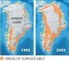
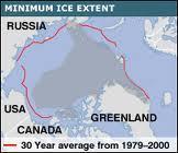
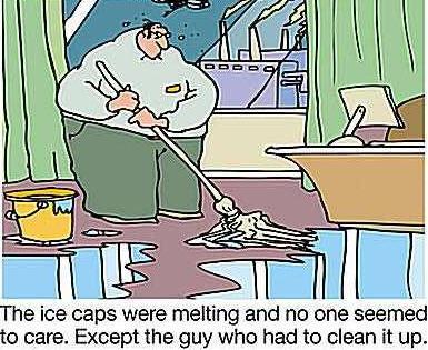
12 Glaciers = Huge amounts of fresh water Melting Glaciers (in summertime) = fresh water to rivers = drinking water for a number of areas examples: Norway, Switzerland, Alaska, Washington State, parts of Canada, Bolder Colorado which is a source for hydroelectric power
13 When glaciers reach 100 ft thick the weight causes them to move or flow. Large amounts of rock and soil are pulled along

14 End Moraine = rock and soil piled up at the end of a melting glacier Outwash = material carried further by melted glacier water


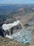
15 When glaciers reach water, pieces break off causing ice bergs in a process called calving


16 TYPES OF GLACIERS Valley Glaciers Piedmont Glaciers


17 ICE CAP GLACIER CONTINENTAL/ ICE SHEET Small domed shaped

18 Melting Ice Sheets


19 Melting Glaciers = if all melt = the oceans will rise approx 130 feet, some cities will go under
20

21
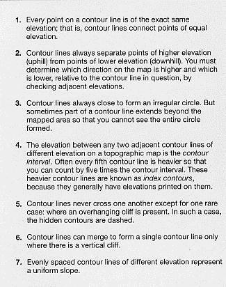
22

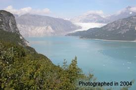
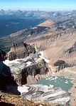
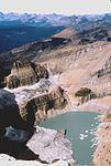
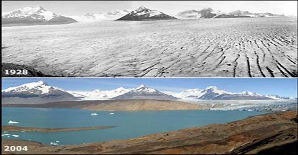
23 Muir Glacier - Alaska


24 In the past 125 years= the Athabasca Glacier Retreat

25 As the glaciers melt, weight is reduced on the continental crust and uplifting occurs = Isostatic Rebound

26 OTZI 5000 year old Iceman, found in 1991 Scientists have poked, prodded, and x-rayed the 5,000-year-old mummy found in the Alps

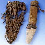
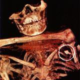
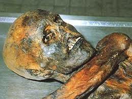

27 he was murdered OTZI
28 Maps
29 Elevation Representation A topographic map shows elevation Contour lines are lines that connect points of equal elevation. sea level starts at ZERO
 BLUE: Water (Sea, Ocean, Lake, River,")
30 Topo Maps are color coded: BROWN/ Black: Contour Lines of Elevation WHITE: Area of No Vegetation GREEN: Vegetation (Forests, Grasslands) BLUE: Water (Sea, Ocean, Lake, River, Pond)
 RED: Significant")
 PINK: Densely")
31 BLACK: Man-Made Features (Buildings, Roads, Mines) RED: Significant Manmade Features (Highway, Government Area) PINK: Densely Populated Urban Area
32 RULES

33 RULES Small dashed lines= depression Contour lines point up hill= water flows in opposite direction
34 Look over the map examples and be able to apply what you know to answer some questions about these types of maps
Exam Review. Part 3- Deserts, Glaciers, and maps
 Exam Review Part 3- Deserts, Glaciers, and maps What causes a desert? Lots of sand Vegetation holds the arms Star Dunes- Star dunes form only in places where wind blows from varied directions over the
GLACIATION. The Last Ice Age (see Chapter 12) and. Pleistocene Ice Cap. Glacial Dynamics 10/2/2012. Laurentide Ice Sheet over NYS
 and. Pleistocene Ice Cap. Glacial Dynamics 10/2/2012. Laurentide Ice Sheet over NYS") GLACIATION and New York State Prof. Anthony Grande The Last Ice Age (see Chapter 1) The Pleistocene Epoch began 1.6 mya. During this time, climates grew colder. There were numerous ice ages starting 100,000000
GLACIATION and New York State Prof. Anthony Grande The Last Ice Age (see Chapter 1) The Pleistocene Epoch began 1.6 mya. During this time, climates grew colder. There were numerous ice ages starting 100,000000
Brain Wrinkles. Africa: The impact of location, climate, & physical characteristics on where people live, the type of work they do, & how they travel
 Africa: The impact of location, climate, & physical characteristics on where people live, the type of work they do, & how they travel STANDARDS: SS7G3 The student will explain the impact of location, climate,
Ancient Egypt. Life Along the Nile River
 Ancient Egypt Life Along the Nile River 2018 Geography How Does Geography affect the way that people live? Geography- Where in the World? You are Here Streetsboro, Ohio United States of America Geography-
Glaciers and Glaciation Earth - Chapter 18 Stan Hatfield Southwestern Illinois College
 Glaciers and Glaciation Earth - Chapter 18 Stan Hatfield Southwestern Illinois College Glaciers Glaciers are parts of two basic cycles: 1. Hydrologic cycle 2. Rock cycle A glacier is a thick mass of ice
Shaping of North America. Physical Geography II of the United States and Canada. The Last Ice Age. The Ice Age. Pleistocene Polar Ice Cap 2/14/2013
 Physical Geography II of the United States and Canada Prof. Anthony Grande AFG 2012 Shaping of North America The chief shaper of the landscape of North America is and has been running water. Glaciation
Introduction to Africa
 Introduction to Africa Did you know? Africa has more countries than any other continent. The Sahara is a desert that is the size of the U.S. It s the world's largest desert. Most of the world s gold and
1 Glacial Erosion and
 www.ck12.org Chapter 1. Glacial Erosion and Deposition CHAPTER 1 Glacial Erosion and Deposition Lesson Objectives Discuss the different erosional features formed by alpine glaciers. Describe the processes
Dynamic Planet C Test
 Northern Regional: January 19 th, 2019 Dynamic Planet C Test Name(s): Team Name: School Name: Team Number: Rank: Score: Dynamic Planet B/C Glaciers (87 total points) Multiple choice/fill in the blank (23
Recrystallization of snow to form LARGE. called FIRN: like packed snowballs. the weight of overlying firn and snow.
 Chapter 11 Glaciers BFRB P. 103-104, 104, 108, 117-120120 Process of Glacier Formation Snow does NOT melt in summer Recrystallization of snow to form LARGE crystals of ice (rough and granular) called
Glaciers Earth 9th Edition Chapter 18 Mass wasting: summary in haiku form Glaciers Glaciers Glaciers Glaciers Formation of glacial ice
 1 2 3 4 5 6 7 8 9 10 11 12 13 14 15 Earth 9 th Edition Chapter 18 Mass wasting: summary in haiku form Ten thousand years thence big glaciers began to melt - called "global warming." are parts of two basic
CH. 1 Europe and Russia: Physical Geography. Section 1 Land and Water p Europe and Russia are part of the world s largest landmass called.
 CH. 1 Europe and Russia: Physical Geography Section 1 Land and Water p.10-16 Europe and Russia are part of the world s largest landmass called. The country of Russia stretches over both continents. About
Glaciers. Chapter 17
 Glaciers Chapter 17 Vocabulary 1. Glacier 2. Snowfield 3. Firn 4. Alpine glacier 5. Continental glacier 6. Basal slip 7. Internal plastic flow 8. Crevasses 9. Glacial grooves 10. Ice shelves 11. Icebergs
The Physical Geography of Long Island
 The Physical Geography of Long Island A Bit About Long Island Length 118 miles Brooklyn to Montauk Geo202 Spring 2012 Width 23 miles at it s widest Area 1,400 square miles Formation of Long Island River
Great Science Adventures
 Great Science Adventures Lesson 18 How do glaciers affect the land? Lithosphere Concepts: There are two kinds of glaciers: valley glaciers which form in high mountain valleys, and continental glaciers
2015 Brain Wrinkles. SS8G1b
 SS8G1b Georgia is a geographically diverse state that is divided into five regions. The first three regions (Appalachian Plateau, Valley and Ridge, and Blue Ridge) are in the mountains and foothills of
glacier Little Ice Age continental glacier valley glacier ice cap glaciation firn glacial ice plastic flow basal slip Chapter 14
 Little Ice Age glacier valley glacier continental glacier ice cap glaciation firn glacial ice plastic flow basal slip glacial budget zone of accumulation zone of wastage glacial surge abrasion glacial
I. Types of Glaciers 11/22/2011. I. Types of Glaciers. Glaciers and Glaciation. Chapter 11 Temp. B. Types of glaciers
 Why should I care about glaciers? Look closely at this graph to understand why we should care? and Glaciation Chapter 11 Temp I. Types of A. Glacier a thick mass of ice that originates on land from the
A funny sounding lake. South American Landforms, Climate, and Vegetation
 A funny sounding lake South American Landforms, Climate, and Vegetation 3 4 Essential Question: How have physical features and climate affected the population distribution of Latin America? 5 I. Landforms
How Glaciers Change the World By ReadWorks
 How Glaciers Change the World How Glaciers Change the World By ReadWorks Glaciers are large masses of ice that can be found in either the oceans or on land. These large bodies of frozen water have big
Dynamic Planet Practice Test Written by Samuel Bressler
 Dynamic Planet Practice Test 2013 Written by Samuel Bressler Part 1: Multiple Choice 1. Which of the following is NOT related to alpine glaciation? a) Serac b) Kame c) Col d) Paternoster Lake 2. The common
Just how big is Africa?
 The United States China India The United Kingdom Portugal Spain France Belgium Germany The Netherlands Switzerland Italy Eastern Europe Japan 11.7 million sq. miles Just how big is Africa? Chapter 18 Section
Latin America. Chapter 9 Physical Geography
 Latin America Chapter 9 Physical Geography Latin American Regions Middle America includes Mexico and the Central American countries The Caribbean Islands South America Mexico Landforms Sierra Madre Oriental
Glaciers. Reading Practice
 Reading Practice A Glaciers Besides the earth s oceans, glacier ice is the largest source of water on earth. A glacier is a massive stream or sheet of ice that moves underneath itself under the influence
SS8G1 The student will describe Georgia with regard to physical features and location.
 SS8G1ab Standards SS8G1 The student will describe Georgia with regard to physical features and location. a. Locate Georgia in relation to the region, nation, continent, and hemispheres. b. Describe the
1.4 Understand how moving ice acts as an agent of erosion and deposition. (Chap. 2)
") 1.4 Understand how moving ice acts as an agent of erosion and deposition. (Chap. 2) There are two types of glaciation. Alpine Glaciation Continental Glaciation Distinguish between the terms alpine glaciation
1.4 Understand how moving ice acts as an agent of erosion and deposition. (Chap. 2) There are two types of glaciation. Alpine Glaciation Continental Glaciation Distinguish between the terms alpine glaciation
Label your Map with Russia. Map Activity
 Bell Activity How many time zones does the U.S. have? How do these time zones affect life in the U.S.? Russia is so large it has 11 time zones. What difficulties might this create? Objectives Know landforms,
Geography: Unit 2. Map. Rivers. Major Physical Features. Slide 1. Slide 2. Slide 3. Slide 4. North America United States and Canada.
 Mississippi River Slide 1 Slide 2 Slide 3 Slide 4 Geography: Unit 2 North America United States Map Major Physical Features Mountain Ranges Brooks Range Mackenzie Mountains Coast Mountains Cascades Sierra
Chapter 7 Geography and the Early Settlement of Egypt, Kush, and Canaan
 Chapter 7 Geography and the Early Settlement of Egypt, Kush, and Canaan How did geography affect early settlement in Egypt, Kush, and Canaan? Section 7.1 - Introduction RF/NASA//Corbis This satellite photograph
Mighty Glaciers. Mighty Glaciers. Visit for thousands of books and materials.
 Mighty Glaciers A Reading A Z Level M Leveled Reader Word Count: 684 LEVELED READER M Mighty Glaciers Written by Ned Jensen Visit www.readinga-z.com for thousands of books and materials. www.readinga-z.com
AFRICAN PHYSICAL GEOGRAPHY
 AFRICAN PHYSICAL GEOGRAPHY Here are some factoids about Africa: world s second largest continent (11,700,000 miles). Home to 52 countries, 1,000 languages, 800 million people. 10% of the world s population
STUDY GUIDE. The Land. Chapter 20, Section 1. The Land of Africa South of the Sahara. Landforms Water Systems Natural Resources.
 For use with textbook pages 499 504. The Land Terms to Know escarpment A steep, often jagged slope or cliff (page 500) cataract A towering waterfall (page 500) rift valley A large crack in the earth s
Friday, November 10, 2017
 Friday, November 10, 2017 Andes and Midlatitude Countries Objective: Summarize the main physical features and regions of the Southern Cone. Identify and locate the urban centers and understand the pattern
2015 Brain Wrinkles. SS8G1b
 SS8G1b Standards SS8G1 The student will describe Georgia with regard to physical features and location. b. Describe the five geographic regions of Georgia; include the Blue Ridge Mountains, Valley and
SS7G1 The student will locate selected features of Africa.
 Standards SS7G1 The student will locate selected features of Africa. a. Locate on a world and regional political-physical map: the Sahara, Sahel, savanna, tropical rain forest, Congo River, Niger River,
Changing Landscapes: Glaciated Landscapes. What are glaciers?
 Changing Landscapes: Glaciated Landscapes What are glaciers? What you need to know Types of ice mass at a range of scales including cirque glaciers, valley glaciers, highland ice field, piedmont glaciers,
Part 1 Glaciers on Spitsbergen
 Part 1 Glaciers on Spitsbergen What is a glacier? A glacier consists of ice and snow. It has survived at least 2 melting seasons. It deforms under its own weight, the ice flows! How do glaciers form? Glaciers
Glaciers. Valley or Alpine glaciers. Ice sheets. Piedmont - foot of the mountain glaciers. Form in mountainous areas Move downslope in valleys
 Glaciers & Ice Ages Glaciers Valley or Alpine glaciers Form in mountainous areas Move downslope in valleys Ice sheets Move outward from center Continental glaciers - large scale, ice age type. Presently
Sub - Saharan Africa
 Sub - Saharan Africa 4/14/2015 Countries with Relative Importance GDP South Africa Gabon Botswana Land Size Sudan Chad Mozambique Madagascar Democratic Republic of the Congo (formerly Zaire) Population
Chapter 7. Geography and the Early Settlement of Egypt, Kush, and Canaan
 Chapter 7 Geography and the Early Settlement of Egypt, Kush, and Canaan Chapter 7 Geography and the Early Settlement of Egypt, Kush, and Canaan How did geography affect early in Egypt Kush, and Canaan?
READING QUESTIONS: Chapter 7, Glaciers GEOL 131 Fall pts. a. Alpine Ice from larger ice masses flowing through a valley to the ocean
 READING QUESTIONS: Chapter 7, Glaciers GEOL 131 Fall 2018 63 pts NAME DUE: Tuesday, October 23 Glaciers: A Part of Two Basic Cycles (p. 192-195) 1. Match each type of glacier to its description: (2 pts)
READING QUESTIONS: Glaciers GEOL /WI 60 pts. a. Alpine Ice from larger ice masses flowing through a valley to the ocean
 READING QUESTIONS: Glaciers GEOL 131 18/WI 60 pts NAME DUE: Tuesday, March 13 Glaciers: A Part of Two Basic Cycles (p. 192-195) 1. Match each type of glacier to its description: (2 pts) a. Alpine Ice from
LOCATION, CLIMATE, AND NATURAL RESOURCES OF MEXICO
 SS6G3 The student will explain the impact of location, climate, distribution of natural resources, and population distribution on Latin America and the Caribbean. a. Compare how the location, climate,
Terms to Know. artesian well coral atoll krill lagoon
 Chapter Objectives Describe the diverse landforms and natural resources of Australia, Oceania, and Antarctica. Discuss the wide range of climates and vegetation throughout the region. The Land Section
Geography: Unit 2. Map. Major Physical Features. Rivers. Mississippi River Missouri River Ohio River Rio Grande. Mackenzie. Colorado River Green River
 1 2 3 4 Geography: Unit 2 North America United States and Canada Map Major Physical Features Mountain Ranges Brooks Range Mackenzie Mountains Coast Mountains Cascades Sierra Nevada Rocky Mountains Appalachian
6th Grade Social Studies Chapter 7: The Geography and Early Settlement of Egypt, Kush and Canaan
 I. Introduction (7.1) A. Egyptians settled along the Nile River, in the NE corner of Africa B. civilization lasted from around 3100 B.C. to 350 C. E. C. Kushites settled to the south of Egypt, along the
Chapter 7: The Geography and Settlement of Egypt, Kush, and Canaan
 Chapter 7: The Geography and Settlement of Egypt, Kush, and Canaan Learning Target: I can explain how geography affected early settlement in Egypt, Kush, and Canaan. Ancient Egypt and the Middle East Can
Glaciers. Glacier Dynamics. Glacier Dynamics. Glaciers and Glaciation. Types of Glaciers. Chapter 15
 Chapter 15 Glaciers and Glaciation Glaciers A glacier is a large, permanent (nonseasonal) mass of ice that is formed on land and moves under the force of gravity. Glaciers may form anywhere that snow accumulation
Teacher s Guide For. Glaciers
 Teacher s Guide For Glaciers For grade 7 - College Program produced by Centre Communications, Inc. for Ambrose Video Publishing, Inc. Executive Producer William V. Ambrose Teacher's Guide by Mark Reeder
Oceania. Australia, New Zealand, and the Pacific Islands. Physical Geography. Where is Australia located?
 Oceania Australia, New Zealand, and the Pacific Islands Physical Geography Australia New Zealand Oceania Where is Australia located? Australia & Oceania are a group of islands located between Asia, Antarctica,
Glaciers are thrilling. Glaciers are Melting McBride Glacier, Glacier Bay. Melting glaciers reveal the effects of glaciation. Why Glaciers?
 Glaciers are thrilling Six trips to SE Alaska, most recent 2015 Additional trips up Inside Passage Author of Glaciers, Bears and Totems Glaciers are Melting McBride Glacier, Glacier Bay 2011 2015 Why Glaciers?
For Creative Minds. Glaciers
 For Creative Minds The For Creative Minds educational section may be photocopied or printed from our website by the owner of this book for educational, non-commercial uses. Cross-curricular teaching activities,
Comparison Pictures of Receding Glaciers
 Comparison Pictures of Receding Glaciers In the photo above, the west shoreline of Muir Inlet in Alaska's Glacier Bay National Park & Preserve is shown as it appeared in 1895. Notice the lack of vegetation
Location, Climate, & Natural Resources
 Location, Climate, & Natural Resources UK is a country of islands off the coast of mainland Europe. It consists of England, Northern Ireland, Scotland, & Wales. UK s location makes it a HUB for trade.
Lesson 1: Land and Climate of the West Land and Water of the West 1. There are 13 states in the West, divided into 3 regions a. Southwest: Nevada,
 Lesson 1: Land and Climate of the West Land and Water of the West 1. There are 13 states in the West, divided into 3 regions a. Southwest: Nevada, Utah, Arizona, New Mexico b. Mountain States: Wyoming,
THE DEPARTMENT OF HIGHER EDUCATION UNIVERSITY OF COMPUTER STUDIES FIFTH YEAR
 THE DEPARTMENT OF HIGHER EDUCATION UNIVERSITY OF COMPUTER STUDIES FIFTH YEAR (B.C.Sc./B.C.Tech.) RE- EXAMINATION SEPTEMBER 2018 Answer all questions. ENGLISH Time allowed: 3 hours QUESTION I Glaciers A
MIDDLE SCHOOL CURRICULUM TR AILING ICE AGE M YST ERI E S SEARCHING GLACIAL FEATURES
 MIDDLE SCHOOL CURRICULUM TR AILING ICE AGE M YST ERI E S SEARCHING GLACIAL FEATURES CONTENTS I. Enduring Knowledge... 3 II. Teacher Background... 3 III. Before Viewing the Video... 5 IV. Viewing Guide...
TEACHER PAGE Trial Version
 TEACHER PAGE Trial Version * After completion of the lesson, please take a moment to fill out the feedback form on our web site (https://www.cresis.ku.edu/education/k-12/online-data-portal)* Lesson Title:
Global Warming in New Zealand
 Reading Practice Global Warming in New Zealand For many environmentalists, the world seems to be getting warmer. As the nearest country of South Polar Region, New Zealand has maintained an upward trend
Mapping the Snout. Subjects. Skills. Materials
 Subjects Mapping the Snout science math physical education Skills measuring cooperative action inferring map reading data interpretation questioning Materials - rulers - Mapping the Snout outline map and
CHAPTER 12. South America. Section 1: Natural Environments Section 2: History and Culture Section 3: South America Today. HOLT World Geography
 CHAPTER 12 South America Section 1: Natural Environments Section 2: History and Culture Section 3: South America 1 Section 1 Natural Environments Objectives: What are the major landforms and rivers of
Kindergarten Science Unit C: Earth Science Chapter 5: Our Land, Air, and Water Lesson 1: What makes up the Earth?
 Insert Photo or Graphic for Unit or Lesson Theme Kindergarten Science Unit C: Earth Science Chapter 5: Our Land, Air, and Water Lesson 1: What makes up the Earth? Insert Photo/Graphic Earth Insert Photo/Graphic
Chapter 7 Snow and ice
 Chapter 7 Snow and ice Throughout the solar system there are different types of large ice bodies, not only water ice but also ice made up of ammonia, carbon dioxide and other substances that are gases
Geography (cont) Sorghum, rice, millet, rice, wheat and corn grown on savannahs. Not just one big plain though mountainous and swampy areas too
 Sorghum, rice, millet, rice, wheat and corn grown on savannahs. Not just one big plain though mountainous and swampy areas too") Geography & Society in Africa: 500 BCE-900 CE Geography Around 5000 miles wide and long Various climates, jungles, snow-capped mountains, deserts and rain-soaked areas. 40% desert - largely uninhabitable
Geography & Society in Africa: 500 BCE-900 CE Geography Around 5000 miles wide and long Various climates, jungles, snow-capped mountains, deserts and rain-soaked areas. 40% desert - largely uninhabitable
GY 301: Geomorphology Lab 9: Alpine Glaciers and Geomorphology
 Name: Raw score: /45 Percentage: /100% Your Task: Today s lab deals with the interpretation of geomorphological features that typically result from alpine glacial activity. The exercises should be able
Unit 1. School Days. First Nine Weeks
 Study Buddy Unit 1 School Days First Nine Weeks Teacher- A person who helps us learn. Map- A drawing that shows where places are. Group- A number of people doing an activity together. Rule- What you must
What Is An Ecoregion?
 Ecoregions of Texas What Is An Ecoregion? Ecoregion a major ecosystem with distinctive geography, characteristic plants and animals, and ecosystems that receives uniform solar radiation and moisture Sometimes
Did It. naturalists. Young. Moving and melting ice shaped many of Minnesota s land features. 30 Minnesota Conservation Volunteer
 Young naturalists by Mary Hoff Photography by Gary Alan Nelson T he Glacier Did It Moving and melting ice shaped many of Minnesota s land features. Shut your eyes. Imagine that it s a sunny summer day
Name Team Number. 1. The famous question: What percent of Earth's surface is covered by glaciers? A) 5% D) neve
 5% D) neve") Part I: Multiple Choice (30pts) Directions: Please choose the best answer for each question. There is only one correct answer for each question unless otherwise stated. There are 30 questions. Each one
Part I: Multiple Choice (30pts) Directions: Please choose the best answer for each question. There is only one correct answer for each question unless otherwise stated. There are 30 questions. Each one
Glaciers and Glaciation
 Chapter 18 Lecture Earth: An Introduction to Physical Geology Eleventh Edition Glaciers and Glaciation Tarbuck and Lutgens Glaciers: A Part of Two Basic Cycles A glacier is a thick mass of ice that forms,
Lesson. Glaciers Carve the Land A QUICK LOOK. Overview. Big Idea. Process Skills Key Notes
 EARTH S CHANGING SURFACE CLUSTER 2 HOW THE EARTH S SURFACE CHANGES Lesson 62 Glaciers Carve the Land A QUICK LOOK Big Idea Moving water, ice, and wind break down rock, transport materials, and build up
Location, Climate, & Natural Resources Brain Wrinkles
 Location, Climate, & Natural Resources Standards SS6G10 The student will explain the impact of location, climate, natural resources, and population distribution on Europe. a. Compare how the location,
4th Grade Social Studies 2nd Nine Weeks Test
 4th Grade Social Studies 2nd Nine Weeks Test Multiple Choice Identify the choice that best completes the statement or answers the question. 1 Which is the largest city in the United States? A Philadelphia,
4th Grade Third 9 Weeks Test
 4th Grade Third 9 Weeks Test Multiple Choice Identify the choice that best completes the statement or answers the question. 1 A waterway for ships that is dug across land is called a. A port C river B
Curriculum Pacing Guide Grade/Course 5 Th Grade Geography Grading Period 1 st Nine Weeks
 2013-2014 Curriculum Pacing Guide Grade/Course 5 Th Grade Grading Period 1 st Nine Weeks Time Frame Unit/ photographs, pictures, and tables to Locate and identify: Continents and Oceans -North America
Geography 120, Instructor: Chaddock In Class 13: Glaciers and Icecaps Name: Fill in the correct terms for these descriptions: Ablation zone: n zne:
 Geography 120, Instructor: Chaddock In Class 13: Glaciers and Icecaps Name: Fill in the correct terms for these descriptions: Ablation zone: The area of a glacier where mass is lost through melting or
Glaciers. Clicker Question. Glaciers and Glaciation. How familiar are you with glaciers? West Greenland. Types of Glaciers.
 Chapter 21 Glaciers A glacier is a large, permanent (nonseasonal) mass of ice that is formed on land and moves under the force of gravity. Glaciers may form anywhere that snow accumulation exceeds seasonal
A trip to Steindalen. - geology and landscape on the way to the glacier. Geoffrey D. Corner
 A TRIP TO STEINDALEN Excursion guide Please take this with you on your trip, but don t leave it behind as litter. A trip to Steindalen - geology and landscape on the way to the glacier A part of Geologiskolen,
Chapter 17. Glacial & Periglacial Landscapes
 Chapter 17 Glacial & Periglacial Landscapes Cryosphere Cryosphere - the portions of Earth's surface where water is in solid form, including sea ice, lake ice, river ice, snow cover, glaciers, ice caps,
Latin America s Physical Geography. EQ: What are characteristics of Latin America s physical features?
 Latin America s Physical Geography EQ: What are characteristics of Latin America s physical features? Your Task: We are going to participate in a Museum Walk! You will travel around the room with a partner
MEEK tart'
 MEEK tart' Post Card Nebraska is one of the nation's leading stock raising areas. It is famous for dairy products. Corn, grain, hay and sugar beets grow in abundance. Industrial activity has rapidly developed.
Chapter 14. The Physical Geography of Russia
 Chapter 14 The Physical Geography of Russia Chapter Objectives Identify the physical features and natural resources of Russia. Discuss the effects of Russia s climate and vegetation on life in the region.
Geologic Trips, Sierra Nevada
 ISBN 0-9661316-5-7 GeoPress Excerpt from Geologic Trips, Sierra Nevada by Ted Konigsmark All rights reserved. No part of this book may be reproduced without written permission, except for critical articles
ENSC454 Snow and Ice: Glaciers April Roger Wheate (NRES)
") ENSC454 Snow and Ice: Glaciers April 1 2015 Roger Wheate (NRES) Roger.Wheate@unbc.ca Sólheimajökull, Iceland The main purpose of snow: it makes glaciers April 1 other uses of snow April 1 uses of glaciers:
ENSC454 Snow and Ice: Glaciers April 1 2015 Roger Wheate (NRES) Roger.Wheate@unbc.ca Sólheimajökull, Iceland The main purpose of snow: it makes glaciers April 1 other uses of snow April 1 uses of glaciers:
THE USA. The capital of USA is Washington D.C., in the District of Columbia.
 THE USA The United States of America is the richest and one of the biggest countries in the world. It has a population of about 295 million people. It is divided into 50 states; two of them, Alaska and
Why Focus on the Polar Regions for impacts from Sea Level Rise? Margie Turrin Lamont-Doherty Earth Observatory of Columbia University
 Why Focus on the Polar Regions for impacts from Sea Level Rise? Margie Turrin Lamont-Doherty Earth Observatory of Columbia University Sea Level has to do with water storage 20,000 yrs ago at the end of
GC 225 Lecture Exam #2
 GC 225 Lecture Exam #2 Direction- path along which something is moving. 3 Types; - COMPASS DIRECTIONAL NAME (32 in total) - BEARING (four 0 o - 90 o ) - AZIMUTHS (0 o - 360 o ) Compass (32 named points)
ESS Glaciers and Global Change
 ESS 203 - Glaciers and Global Change Friday January 5, 2018 Outline for today Please turn in writing assignment and questionnaires. (Folders going around) Questions about class outline and objectives?
Unit 6 vocabulary. Serengeti Plain
 basin Nile River rift valley Mount Kilimanjaro escarpment Sahara aquifer oasis Serengeti Plain canopy Niger delta Sahel the world s longest river, flowing more than 4,000 miles through Uganda and Sudan
Chapter 17. North Africa, Southwest Asia and Central Asia
 Chapter 17 North Africa, Southwest Asia and Central Asia Chapter Objectives Describe the major landforms and natural resources of North Africa, Southwest Asia, and Central Asia. Discuss the climate and
Chapter 16 Glaciers and Glaciations
 Chapter 16 Glaciers and Glaciations Name: Page 419-454 (2nd Ed.) ; Page 406-439 (1st Ed.) Part A: Anticipation Guide: Please read through these statements before reading and mark them as true or false.
APPENDIX E GLACIERS AND POLAR ICE CAPS
 APPENDIX E GLACIERS AND POLAR ICE CAPS GLACIERS The dictionary defines a glacier as a large mass of ice and snow that forms in areas where the rate of snowfall constantly exceeds the rate at which the
All of this week s homework is intended to help you get to know more about the country of Sudan, where Kek is from in Home of the Brave.
 Name: Week 7 Homework All of this week s homework is intended to help you get to know more about the country of Sudan, where Kek is from in Home of the Brave. On the map above, do the following things:
*Latin America spans 7,000 miles, from Mexico to Tierra Del Fuego. *3 Regions: Central America, South America, and the Caribbean.
 Physical Geography Latin America spans 7,000 miles, from Mexico to Tierra Del Fuego *3 Regions: Central America, South America, and the Caribbean. *Intro clip: http://www.youtube.com/watch?v=cffp6rza3
Chapter 10 Test on Australia
 Name Score Chapter 10 Test on Australia Part 1 - True/False Read each statement carefully. If it is true, clearly mark T in the blank space. If it is false, clearly mark F in the blank space. For false
Please make sure that all teachers and chaperones attending the field study are aware of the following information:
 Dear Teacher, Thank you for signing up for The Ice Age at the Lost Valley Visitor Center in Glacial Park. The visitor center is located in the middle of Glacial Park. Follow the signs from the Harts Road
Glaciers. Glacier Dynamics. Glaciers and Glaciation. East Greenland. Types of Glaciers. Chapter 16
 Chapter 16 Glaciers A glacier is a large, permanent (nonseasonal) mass of ice that is formed on land and moves under the force of gravity. Glaciers may form anywhere that snow accumulation exceeds seasonal
The Geological Pacific Northwest. Wednesday February 6, 2012 Pacific Northwest History Mr. Rice
 The Geological Pacific Northwest Wednesday February 6, 2012 Pacific Northwest History Mr. Rice 1 Free Response #2 Please do not simply list the items for this response. Full sentences!!! Minimum of 3-5
Lesson 1: Geography of Africa
 Lesson 1: Geography of Africa 7. 4. 1 Study the Niger River and the relationship of Vegetation zones of forest, savannah, and desert trade in gold, salt, food, and slaves; and the growth of the Ghana and
MCGRAW-HILL EUROPE. Chapter 11 Physical Geography Pages 332 to 341
 MCGRAW-HILL EUROPE Chapter 11 Physical Geography Pages 332 to 341 Countries of Western Europe Benelux Countries UK, France, Luxembourg, Germany, Netherlands, Belgium, Austria, Switzerland, Belgium, Monaco,