Chapter 2A: The Russian Realm
|
|
|
- Marybeth Martin
- 6 years ago
- Views:
Transcription
1 Geography: Realms, Regions, and Concepts 16 th Edition Chapter 2A: The Russian Realm
2

3 The Russian Realm Two transition zones mark the margins.

4 The Russian Realm Two transition zones mark the margins.
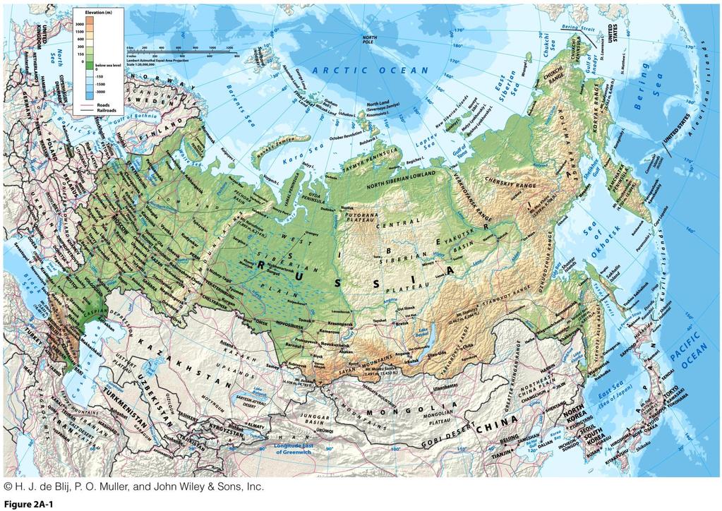
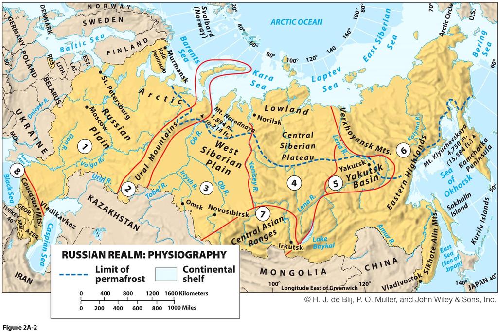
5 Physical Geography of the Russian Realm: Physiographic Regions The Russian Plain (1) Continuation of North European lowland Russia s core area Ural Mountains (2) North-south mountains not tall enough to hinder transportation Divides Russia into two vast expanses of low relief: Russian Plain to the West Siberia to the East Russian Plain as the Eurasian heartland: Center of great landmass Major influence on history Potential vulnerability
6
7 Physical Geography of the Russian Realm: Physiographic Regions Siberia West Siberian Plain (3) World s largest unbroken lowland where rivers flow northward, like the Ob River Central Siberian Plateau (4) East of the Yenisey River Higher relief Most sparsely populated areas in the habitable world Yakutsk Basin (5) Moderate topography drained by the Lena River Eastern Highlands (6) Remote jumble of ranges

 Barrier and zone of conflict for")
8 Physical Geography of the Russian Realm: Kamchatka and Sakhalin Pacific Ring of Fire Physiographic Regions Kamchatka Peninsula Volatile volcanism Sakhalin Island Prevalent earthquakes Oil and gas reserves The Southern Perimeter Central Asian Ranges (7) High relief location of Lake Baykal Avacha Volcano, Kamchatka Peninsula Barbara Weightman Caucasus Mountains (8) Barrier and zone of conflict for Russia and neighbors
9 Physical Geography of the Russian Realm: Physiographic Regions Kamchatka and Sakhalin Pacific Ring of Fire Kamchatka Peninsula Volatile volcanism Sakhalin Island Prevalent earthquakes Oil and gas reserves The Southern Perimeter Central Asian Ranges (7) High relief location of Lake Baykal Caucasus Mountains (8) Barrier and zone of conflict for Russia and neighbors
 High relief location of Lake Baykal Caucasus Mountains (8) Barrier and zone of conflict for Russia")
10 Physical Geography of the Russian Realm: Physiographic Regions Kamchatka and Sakhalin Pacific Ring of Fire Kamchatka Peninsula Volatile volcanism Sakhalin Island Prevalent earthquakes Oil and gas reserves The Southern Perimeter Central Asian Ranges (7) High relief location of Lake Baykal Caucasus Mountains (8) Barrier and zone of conflict for Russia and neighbors
11 Physical Geography of the Russian Realm: Physiographic Regions Kamchatka and Sakhalin Pacific Ring of Fire Kamchatka Peninsula Volatile volcanism Sakhalin Island Prevalent earthquakes Oil and gas reserves The Southern Perimeter Central Asian Ranges (7) High relief location of Lake Baykal Caucasus Mountains (8) Barrier and zone of conflict for Russia and neighbors
 High relief location of Lake Baykal Caucasus Mountains (8) Barrier and zone of conflict for Russia")
12 Physical Geography of the Russian Realm: Physiographic Regions Kamchatka and Sakhalin Pacific Ring of Fire Kamchatka Peninsula Volatile volcanism Sakhalin Island Prevalent earthquakes Oil and gas reserves The Southern Perimeter Central Asian Ranges (7) High relief location of Lake Baykal Caucasus Mountains (8) Barrier and zone of conflict for Russia and neighbors

13 Physical Geography of the Russian Realm: Climate context: continentality Harsh Environments Inland climatic environment remote from moderating and moistening maritime influence Environmental effect: Permafrost: water in the ground permanently frozen High latitude ecology Tundra: bare ground and rock with lichen, mosses, and low grass Taiga: snowforest of coniferous trees (Boreal)

14 Physical Geography of the Russian Realm: Climate and Peoples Climate and weather make farming difficult: Seasonal temperature extremes Variable rainfall Short, undependable growing seasons Limitations on agriculture explain realm s population distribution. Harsh Environments
15 Physical Geography of the Russian Realm: Harsh Environments Climate Change and Arctic Prospects Lengthy northern coastline on the Arctic Ocean Mostly frozen throughout the year Global warming and possibilities for the future Melting of Arctic Ocean s ice cover, opening up of Arctic ports, and even passage through the Bering Strait Shrinking the area of permafrost Improvement of agriculture on the Russian Plain New oil and gas reserves Expanding the Russian geographic realm northward
16 Physical Geography of the Russian Realm: Ecologies at Risk Harsh Environments Global warming and environmental disruption: Animal and human communities have adapted to the harsh prevailing climate conditions of the Arctic. New oil and natural gas exploration: Offshore environments could also face dangers as these new resources become exploited. Globalization forces are infiltrating a part of the world long protected by distance and nature.

17 Russia s Natural Riches Nearly all raw materials required by modern industry are present: Oil and natural gas Coal, iron ore, and other metals Much of the realm is yet to be fully explored.
18 Russian Roots 1000 years ago: Slavic settlement, or Rus Established in present-day Ukraine and southwestern corner of the Russian Plain Location had physical landscape favorable to settlement and agriculture Many Russians today see Ukraine as their historic heartland Eventually spanned ecological regions, of northern forests and southern steppes, or semiarid grasslands
19 Russian Roots: The Mongol Invasion Mongol-Tatar horse armies were sent to conquer Russes. Russian Plains Russes were vulnerable on open steppes. Forest Russes were able to fend off the Tatars. Russes paid tribute to the Mongol-Tatar invaders. Moscow established trade with other Russes. Mongols attacked Moscow again and failed. Some Tatars stayed in the periphery of the realm. Many eventually converted to Islam.

20 Fourteenth-century rise Russian Roots: Grand Duchy of Muscovy Rule of princes or dukes Extension of trade and religious ties Three centuries of territorial growth By sixteenth century Was a military power in nearly constant warfare Imperial state with centralized administrative control
21
22 Building the Russian Empire: Peter the Great led a modern, European-style state: St. Petersburg built as a forward capital on edge of Swedish-held Finland on the Baltic Developed as Russia s leading port for trade Researched shipbuilding for Russia to become a naval power Czarist Russia Other czars continued to conquer peoples and territory: Russian colonists settled southeastern frontiers and beyond
23 Building the Russian Empire: Czarist Russia Catherine the Great Expanded Russia even further Meanwhile: Russian colonists settled southeastern frontiers and beyond From Siberia, crossing the Bering Strait Russian departure: Competition with American, Canadian, and British hunters who were destroying sea otter populations Russia sold off its North American holdings in 1867
24

25 Building the Russian Empire: Nineteenth-Century Expansion Extension into Eurasia continued: South- and westward Central Asia Including Muslim peoples given some autonomy Trans-Siberian Railroad and occupation of Manchuria Threatened Japan and sparked war in 1904 Defeated by Japan, losing some territory Expansion through imperialism Necessary because of the limitations of Russia s site
26 Building the Russian Empire: A Multinational Empire Russian expansionism annexed and incorporated many nationalities and cultures. Russia controlled as much as 100 different nationalities. The Russian Revolution was a struggle among Russian citizens: Communities won out, creating the Soviet Union. Colonized people were given autonomy and identity, yet strengthened political and economic subjugation.
Label your Map with Russia. Map Activity
 Bell Activity How many time zones does the U.S. have? How do these time zones affect life in the U.S.? Russia is so large it has 11 time zones. What difficulties might this create? Objectives Know landforms,
Chapter 14. The Physical Geography of Russia
 Chapter 14 The Physical Geography of Russia Chapter Objectives Identify the physical features and natural resources of Russia. Discuss the effects of Russia s climate and vegetation on life in the region.
Monday, December 11, 2017
 Monday, December 11, 2017 Physical Geography of Russia Objective: complete Warm-Up, write outline notes and discuss the geography of Eastern Europe/mother Russia and view Geography Now: Belarus. География
Chapter 15: RUSSIA & The REPUBLICS
 Chapter 15: RUSSIA & The REPUBLICS Ch. 15:1 Landforms & Resources The Northern European Plain stretches for over 1,000 miles between the western border of Russia & the Republics and the. Ural Mountains
Chapter 13 Eastern Europe & Western Russia: Recovering from war, communism, genocide, and unfortunate geography (Pg )
") Chapter 13 Eastern Europe & Western Russia: Recovering from war, communism, genocide, and unfortunate geography (Pg. 393-420) Lesson 1: Physical Geography of Eastern Europe & Western Russia Pg. 396-401
Chapter 13 Eastern Europe & Western Russia: Recovering from war, communism, genocide, and unfortunate geography (Pg. 393-420) Lesson 1: Physical Geography of Eastern Europe & Western Russia Pg. 396-401
CH. 1 Europe and Russia: Physical Geography. Section 1 Land and Water p Europe and Russia are part of the world s largest landmass called.
 CH. 1 Europe and Russia: Physical Geography Section 1 Land and Water p.10-16 Europe and Russia are part of the world s largest landmass called. The country of Russia stretches over both continents. About
Ms. Susan M. Pojer Horace Greeley HS Chappaqua, NY
 Ms. Susan M. Pojer Horace Greeley HS Chappaqua, NY Europe as a Queen Munster, 1588 Europe s s Latitude v. US Former Soviet Region Compared in Latitude & Area with the United States Satellite View of Europe
Mediterranean Europe
 Chapter 17, Section World Geography Chapter 17 Mediterranean Europe Copyright 2003 by Pearson Education, Inc., publishing as Prentice Hall, Upper Saddle River, NJ. All rights reserved. Chapter 17, Section
Chapter 20. The Physical Geography of Africa South of the Sahara
 Chapter 20 The Physical Geography of Africa South of the Sahara Chapter Objectives Identify the major landforms, water systems, and natural resources of Africa south of the Sahara. Describe the relationship
Location, Climate, & Natural Resources Brain Wrinkles
 Location, Climate, & Natural Resources Standards SS6G10 The student will explain the impact of location, climate, natural resources, and population distribution on Europe. a. Compare how the location,
Physical Geography of Europe. Chapters 13-18
 Physical Geography of Europe Chapters 13-18 The British Isles Archipelago made of 6000+ small islands Temperate climate Largest body of fresh water is Loch Ness Mostly rolling hills and large flat lands
GEOGRAPHY AND HISTORY
 GEOGRAPHY AND HISTORY YEAR 1, PART 1 www.vicensvives.es Contents 01 Our planet Earth 02 The representation of the Earth: maps 03 The Earth s relief 04 Rivers and seas 05 Weather and climate 06 Climates
Terms to Know. artesian well coral atoll krill lagoon
 Chapter Objectives Describe the diverse landforms and natural resources of Australia, Oceania, and Antarctica. Discuss the wide range of climates and vegetation throughout the region. The Land Section
Chapter 17. North Africa, Southwest Asia and Central Asia
 Chapter 17 North Africa, Southwest Asia and Central Asia Chapter Objectives Describe the major landforms and natural resources of North Africa, Southwest Asia, and Central Asia. Discuss the climate and
Location, Climate, & Natural Resources
 Location, Climate, & Natural Resources UK is a country of islands off the coast of mainland Europe. It consists of England, Northern Ireland, Scotland, & Wales. UK s location makes it a HUB for trade.
The Geological Pacific Northwest. Wednesday February 6, 2012 Pacific Northwest History Mr. Rice
 The Geological Pacific Northwest Wednesday February 6, 2012 Pacific Northwest History Mr. Rice 1 Free Response #2 Please do not simply list the items for this response. Full sentences!!! Minimum of 3-5
,/ /fuor/vu. 2O4 Unit 4. .\ Lapte. _--/ 500/ /11,000 kilometers --\ I R 2\::% Bar'ents,/ ZemlYa ATLANTIC OCEAN. Black Sea
 F urope and Russia occupy E patt of the huge landmass called Eurasia. Eurasia reaches from the Atlantic to the Pacific Ocean. lt is so large that geographers divide it into two continents, Europe and Asia.
STUDY GUIDE. The Land. Physical Features of Latin America. Chapter 8, Section 1. Terms to Know DRAWING FROM EXPERIENCE ORGANIZING YOUR THOUGHTS
 For use with textbook pages 193 198. The Land Terms to Know cordillera A mountain range that runs parallel to another mountain range (page 194) altiplano A high plain (page 194) escarpment A steep cliff
Chapter 12 Study Guide Eastern Europe
 Chapter 12 Study Guide Eastern Europe Eastern Europe is called a. The,, and of countries are constantly changing. I. Baltic Region: Landform that dominates is the Plain A. Poland: suffered due to a lack
Mexico. Chapter 10. Chapter 10, Section
 Chapter 10, Section World Geography Chapter 10 Mexico Copyright 2003 by Pearson Education, Inc., publishing as Prentice Hall, Upper Saddle River, NJ. All rights reserved. Chapter 10, Section World Geography
Chapter Objectives. Describe the dominant landforms and natural resources of Southeast Asia. Discuss Southeast Asia s climate and vegetation.
 Chapter Objectives Describe the dominant landforms and natural resources of Southeast Asia. Discuss Southeast Asia s climate and vegetation. The Land Section 1 Objectives Describe how tectonic plates and
STUDY GUIDE. The Land. Chapter 29, Section 1. Both. Terms to Know DRAWING FROM EXPERIENCE ORGANIZING YOUR THOUGHTS
 Chapter 29, Section 1 For use with textbook pages 719 724. The Land Terms to Know cordilleras Parallel mountain ranges and plateaus (page 719) archipelago A group of islands (page 720) insular Relating
Geography: Unit 2. Map. Rivers. Major Physical Features. Slide 1. Slide 2. Slide 3. Slide 4. North America United States and Canada.
 Mississippi River Slide 1 Slide 2 Slide 3 Slide 4 Geography: Unit 2 North America United States Map Major Physical Features Mountain Ranges Brooks Range Mackenzie Mountains Coast Mountains Cascades Sierra
We re Starting Period 2 Today!
 We re Starting Period 2 Today! We re dealing mainly with the following civilizations: Persia Greece Rome China India PERIOD 2 Includes the Following Chapters: - Chapter 3: Eurasia- Political Chapter 4:
LOCATION, CLIMATE, AND NATURAL RESOURCES OF MEXICO
 SS6G3 The student will explain the impact of location, climate, distribution of natural resources, and population distribution on Latin America and the Caribbean. a. Compare how the location, climate,
Oceania. Australia, New Zealand, and the Pacific Islands. Physical Geography. Where is Australia located?
 Oceania Australia, New Zealand, and the Pacific Islands Physical Geography Australia New Zealand Oceania Where is Australia located? Australia & Oceania are a group of islands located between Asia, Antarctica,
CENTRAL HISTORICAL QUESTION WHY DO THE BALKANS MATTER?
 CENTRAL HISTORICAL QUESTION WHY DO THE BALKANS MATTER? Collection of maps & historical facts that, collectively, spell why the Balkans matter in the origin story of WWI. The Balkan Peninsula, popularly
Relative Location. originally in the today outdated today centered in population center closet to Channel Tunnel.
 NAME PERIOD LOCATION OF INDUSTRIAL REGIONS AROUND THE WORLD DIRECTIONS: Complete the following chart using Chapter 11 Key Issue # 1 in your textbook. Describe the relative location of each region and the
LATIN AMERICA. Mexico Central America Caribbean Islands South America
 LATIN AMERICA Mexico Central America Caribbean Islands South America HISTORY First Settlers Hunters/gatherers from Asia crossed land bridge connecting Asia and Alaska Learned to farm over time Maize (corn)
Economics 300: The Economy of Alaska NOTES: INTRODUCTION TO ALASKA GEOGRAPHY by Gunnar Knapp Updated January 16, 2005
 Economics 300: The Economy of Alaska NOTES: INTRODUCTION TO ALASKA GEOGRAPHY by Gunnar Knapp Updated January 16, 2005 These notes provide a brief introduction to features of Alaska geography which are
The Rise of Rome. Chapter 5.1
 The Rise of Rome Chapter 5.1 The Land and the Peoples of Italy Italy is a peninsula about 750 miles long north to south. The run down the middle. Three important fertile plains ideal for farming are along
Latin America and The Caribbean. A Closer Look.
 Latin America and The Caribbean A Closer Look. Mexico Capital: Mexico City The Location of Mexico Mexico is the second-largest country by size and population in Latin America.but the Largest Spanish -
The Byzantine Empire and Russia ( )
") Copyright 2003 by Pearson Education, Inc., publishing as Prentice Hall, Upper Saddle River, NJ. All rights reserved. Chapter 10, Section World History: Connection to Today Chapter 10 The Byzantine Empire
Copyright 2003 by Pearson Education, Inc., publishing as Prentice Hall, Upper Saddle River, NJ. All rights reserved. Chapter 10, Section World History: Connection to Today Chapter 10 The Byzantine Empire
Wednesday, April 4, 2018
 Wednesday, April 4, 2018 Physical Geography of Japan Objective: Outline the countries and territories that are included in East Asia. Describe the main physical features and climate types of each country.
Chapter 10. Transoceanic Exploration (750 to 1500 CE)
") Chapter 10 Transoceanic Exploration (750 to 1500 CE) Muslim Domination of the Afro-Eurasian Region: 750 CE 1258 CE During the Abbasid Dynasty, Muslim rulers controlled most international trade routes in
Chapter 10 Transoceanic Exploration (750 to 1500 CE) Muslim Domination of the Afro-Eurasian Region: 750 CE 1258 CE During the Abbasid Dynasty, Muslim rulers controlled most international trade routes in
Regional Atlas: Introduction to Latin America
 Chapter 9, Section World Geography Chapter 9 Regional Atlas: Introduction to Latin America Copyright 2003 by Pearson Education, Inc., publishing as Prentice Hall, Upper Saddle River, NJ. All rights reserved.
Geography: Unit 2. Map. Major Physical Features. Rivers. Mississippi River Missouri River Ohio River Rio Grande. Mackenzie. Colorado River Green River
 1 2 3 4 Geography: Unit 2 North America United States and Canada Map Major Physical Features Mountain Ranges Brooks Range Mackenzie Mountains Coast Mountains Cascades Sierra Nevada Rocky Mountains Appalachian
Why is the US industry and agriculture prosperous? The US industry and agriculture is so prosperous because it has many different natural resources.
 Ch. 1-7 Study Guide Why is the US industry and agriculture prosperous? The US industry and agriculture is so prosperous because it has many different natural resources. What likely drew immigrants to the
Athens and Sparta. Chapter 7, Section 2
 Athens and Sparta Chapter 7, Section 2 Objectives In this section you will 1. Learn how people lived in ancient Sparta. 2. Discover some results of the Persian invasion of Greece. 3. Understand the conflicts
Investment possibilities of municipal formation KINGISEPP MUNICIPAL DISTRICT. This project is funded by the European Union
 Investment possibilities of municipal formation KINGISEPP MUNICIPAL DISTRICT This project is funded by the European Union Kingisepp municipal district is situated in the South-West of Leningrad Region.
International Scientific and Practical Symposium "Transforming Society: new directions and models of social development"
 International Scientific and Practical Symposium "Transforming Society: new directions and models of social development" Time - 8-10 June 2015. Venue - Yakutsk The organizers - the Government of the Republic
North Africa. Chapter 25. Chapter 25, Section
 Chapter 25, Section World Geography Chapter 25 North Africa Copyright 2003 by Pearson Education, Inc., publishing as Prentice Hall, Upper Saddle River, NJ. All rights reserved. Chapter 25, Section World
Chapter 16 ~ Eastern Mediterranean
 Chapter 16 ~ Eastern Mediterranean Physical Geography of the Eastern Mediterranean Landforms This area is known as the Levant and includes Syria, Jordan, Lebanon, Israel, and the Palestinian territories.
Europe. World Geography
 Europe World Geography Physical Geography Europe s landforms also include large plains and mountain ranges. Europe is composed of many peninsulas and islands. Always near Water Europe is a large peninsula
EXPLORING BIOMES IN GORONGOSA NATIONAL PARK
 EXPLORING BIOMES IN GORONGOSA NATIONAL PARK ABOUT THIS WORKSHEET This worksheet complements the Click and Learn Gorongosa National Park Interactive Map (http://www.hhmi.org/biointeractive/gorongosa-national-park-interactive-map),
CANADA: ITS LAND, RESOURCES, & ECONOMY PRE-TEST
 PRE-TEST Name Directions: In the blank space, write a "T" if the statement is true and an "F" if the statement is false. 1. Canada has 11 geographic regions. 2. The cordillera is found in central Canada.
STANDARDS: Brain Wrinkles
 STANDARDS: SS6G3 The student will explain the impact of location, climate, distribution of natural resources, and population distribution on Latin America and the Caribbean. a. Compare how the location,
Geographic Qualities of South America
 Geographic Qualities of South America 1. South America is the fourth largest continent in area. It is located in the Western Hemisphere, lying southwest of North America. Most of South America lies in
Chapter 16 ~ Eastern Mediterranean
 Chapter 16 ~ Eastern Mediterranean Physical Geography of the Eastern Mediterranean Landforms This area is known as the Levant and includes Syria, Jordan, Lebanon, Israel, and the Palestinian territories.
CHAPTER 12. South America. Section 1: Natural Environments Section 2: History and Culture Section 3: South America Today. HOLT World Geography
 CHAPTER 12 South America Section 1: Natural Environments Section 2: History and Culture Section 3: South America 1 Section 1 Natural Environments Objectives: What are the major landforms and rivers of
MCGRAW-HILL EUROPE. Chapter 11 Physical Geography Pages 332 to 341
 MCGRAW-HILL EUROPE Chapter 11 Physical Geography Pages 332 to 341 Countries of Western Europe Benelux Countries UK, France, Luxembourg, Germany, Netherlands, Belgium, Austria, Switzerland, Belgium, Monaco,
Warm ups *What is unique about the status of Switzerland? *How Austria s history differed from that of Switzerland?
 Warm ups 12.07.2016 *What is unique about the status of Switzerland? *How Austria s history differed from that of Switzerland? Lesson Objective: *describe how Spain differs physically, economically, and
2018 Spring Semester Final : STUDY GUIDE
 Name: Hr: 2018 Spring Semester Final : STUDY GUIDE My final is on:, May My final will have questions and will be COLONIZATION OF NORTH & SOUTH AMERICA - Match the regions with the European countries that
STUDY GUIDE. The Land. Chapter 20, Section 1. The Land of Africa South of the Sahara. Landforms Water Systems Natural Resources.
 For use with textbook pages 499 504. The Land Terms to Know escarpment A steep, often jagged slope or cliff (page 500) cataract A towering waterfall (page 500) rift valley A large crack in the earth s
6th Grade Western Hemisphere Geography
 6th Grade Western Hemisphere Geography Multiple Choice Identify the choice that best completes the statement or answers the question. 1 Latin America is located in the A Northern Hemisphere. C Western
Academic Vocabulary Social Studies, 5-8 (adapted from Building Academic Vocabulary by Robert Marzano.)
") Academic Vocabulary Social Studies, 5-8 (adapted from Building Academic Vocabulary by Robert Marzano.) Provide a student-friendly description, explanation, or example of the term. 7 Continents of the World
Academic Vocabulary Social Studies, 5-8 (adapted from Building Academic Vocabulary by Robert Marzano.) Provide a student-friendly description, explanation, or example of the term. 7 Continents of the World
Brain Wrinkles. Location, Climate, & Natural Resources of. Where People Live & How They Trade
 Location, Climate, & Natural Resources of Where People Live & How They Trade It s south of the US, east of the Pacific Ocean, and west of the Gulf of Mexico & Caribbean Sea. It s great that it s located
Chapter 4. Daily Focus Skills
 Chapter 4 Daily Focus Skills Chapter 4 On a historical map of the ancient Mediterranean area, locate Greece and trace the boundaries of its influence to 300 BC/BCE. Explain how the geographical location
PART 1. EXECUTIVE SUMMARY. English Translation of the Russian Original
 REVISION OF THE PARTIAL SUBMISSION OF THE RUSSIAN FEDERATION TO THE COMMISSION ON THE LIMITS OF THE CONTINENTAL SHELF RELATED TO THE CONTINENTAL SHELF IN THE SEA OF OKHOTSK PART 1. EXECUTIVE SUMMARY English
The Classical Empires
 The Classical Empires Mr. Stille WHAP Population Growth Urbanization Afro-Eurasia in 500 BCE Afro-Eurasia in 350 BCE Afro-Eurasia in 200 BCE Afro-Eurasia in 100 CE Persian Empire Persian Empire (558-332
Latin America. Introduction
 Latin America Introduction What are the 5 Themes of Geography? Draw lines to connect the theme to the definition: Location How humans and the environment impact each other Physical and human characteristics
Lesson 1
 Lesson 1 Objectives Evaluate how geography affected people of the Aegean Cultures. Study the effects of trade on he growth of the Minoan customs and ideas to their way of life. Observe how the Mycenaeans
THE BRITISH ISLES AND NORDIC NATIONS. Chapter 15
 THE BRITISH ISLES AND NORDIC NATIONS Chapter 15 A LITTLE CONFUSING. UK refers to the political union between the countries. -Sovereign state but nations are also individual countries. Great Britain is
Match the names below with their locations on the map by writing the correct letter in the blank.
 P r e v i e w Match the names below with their locations on the map by writing the correct letter in the blank. Physical Features of Canada 60ºN 70ºN 80ºN A R C T I C O C E A N 130ºW 120ºW 110ºW 90ºW 70ºW
Human Geography of Canada
 Human Geography of Canada History and Government of Canada Like the United States, people migrated across Beringia into Canada, these people were the ancestors of the Inuit (Eskimos) 16 th and 17 th centuries,
Chapter 10 Test on Australia
 Name Score Chapter 10 Test on Australia Part 1 - True/False Read each statement carefully. If it is true, clearly mark T in the blank space. If it is false, clearly mark F in the blank space. For false
The Rise of Rome. After about 800 BC other people also began settling in Italy The two most notable were the and the
 The Rise of Rome The Land and People of Italy Italy is a peninsula extending about miles from north to south and only about 120 miles wide. The mountains form a ridge from north to south down the middle
Physical characteristics and biomes:
 Physical characteristics and biomes: Sahel region, bordering Sahara Characteristics Area suffers from lack of rainfall, over grazing, which causes loss of vegetation and loss of inhabitable areas causing
Latin America. Physical Geography
 Latin America Physical Geography Regions Latin America can be divided into separate regions based on physical geography or cultural geography. Regions If we look at physical geography Latin America has
Latin America. Physical Geography
 + Latin America Physical Geography + I. Landforms A. Caribbean & Central America 1. Mexico is dominated by two mountain chains, collectively called the Sierra Madre. A high plateau is situated in between.
World History I SOL WH1.7a, c, e Mr. Driskell
 World History I SOL WH1.7a, c, e Mr. Driskell Constantinople was located on the Bosporus Strait, in modern day Turkey. It was put there for several reasons. First, protection. It was located on an easily
Curriculum Pacing Guide Grade/Course 5 Th Grade Geography Grading Period 1 st Nine Weeks
 2013-2014 Curriculum Pacing Guide Grade/Course 5 Th Grade Grading Period 1 st Nine Weeks Time Frame Unit/ photographs, pictures, and tables to Locate and identify: Continents and Oceans -North America
Developing Siberia s Raw Materials: An Adventure for the 21st Century
 Click here for Full Issue of EIR Volume 37, Number 40, October 15, 2010 Dr. Sergei Cherkasov Developing Siberia s Raw Materials: An Adventure for the 21st Century Dr. Sergei Cherkasov addressed the Schiller
^-.^.^TK'^^.?' ".. Information and Exercises. about. The Territories. Yukon Territory Northwest Territories. Nunavut Territory.
 ^-.^.^TK'^^.?' ".. Information and Exercises about The Territories Yukon Territory Northwest Territories Nunavut Territory Whitehorse, Yukon fyukon TERRITORY ] Key Words: taiga- northern forest area boreal-
Remember from last class...
 The Onset of War! Remember from last class... The republic lasted for nearly 500 years and this period marked major expansion of Roman power. During this time, Rome became the leading power in the Mediterranean.
7/27/2010. Regions of Subsaharan Africa. SUBSAHARAN AFRICA II (Chapter 6, pages ) Southern Africa. South Africa: Peaceful Change from Apartheid
 Southern Africa. South Africa: Peaceful Change from Apartheid") SUBSAHARAN AFRICA II (Chapter 6, pages 209-227) Regions of Subsaharan Africa Southern Africa 10 countries, 6 of them landlocked Congo Basin marks northern limit Plateau country Rich in natural resources
SUBSAHARAN AFRICA II (Chapter 6, pages 209-227) Regions of Subsaharan Africa Southern Africa 10 countries, 6 of them landlocked Congo Basin marks northern limit Plateau country Rich in natural resources
Japan is basically a mountainous volcanic Island Chain located in the western Pacific Ocean
 I N T R O D U C T I O N T O J A PA N Japan is basically a mountainous volcanic Island Chain located in the western Pacific Ocean The country has four main Islands HOKKAIDO HONSHU SHIKOKU KYUSHU And then
UNIT 5 AFRICA PHYSICAL GEOGRAPHY SG 1 - PART II
 UNIT 5 AFRICA PHYSICAL GEOGRAPHY SG 1 - PART II III. CLIMATE & VEGETATION A. The four main climate zones are tropical wet, tropical wet/dry (split into monsoon & savanna), semiarid, and arid. Other climate
CIS MINING SURVEY. Market research Mining equipment analysis Market entry strategy F I N D E T R A O Y
 CIS MINING SURVEY Market research Mining equipment analysis Market entry strategy F I N D E T R A O Y P.O.B. 27 FIN 33311 Tampere, FINLAND tel. +358 3 3423 777 www.findetra.fi Bank: Nordea 158430-101309
Chapter 6. Early Societies in the Americas and Oceania. 2011, The McGraw-Hill Companies, Inc. All Rights Reserved.
 Chapter 6 Early Societies in the Americas and Oceania 1 Early Mesoamerican Societies, 1200 B.C.E.-1100 C.E. 2 Origins of Mesoamerican Societies Migration across Bering land bridge? Probably 13,000 B.C.E.,
The North Africa Campaign:
 The North Africa Campaign: The Battle of El Alamein October 1942 General Rommel, The Desert Fox General Montgomery ( Monty ) North Africa Before 1942, the Axis suffered only 3 major defeats: Commonwealth
Lesson 1: Geography of Africa
 Lesson 1: Geography of Africa 7. 4. 1 Study the Niger River and the relationship of Vegetation zones of forest, savannah, and desert trade in gold, salt, food, and slaves; and the growth of the Ghana and
The Maltese Islands: Geography
 The Maltese Islands: Geography The Maltese Archipelago comprises a group of small low islands aligned in a NW-SE direction. At their extreme points the Maltese Islands fall within the following points:
Trans-Siberian. Monkeyshrine. Train Journeys. Trans-Mongolian Railway: Beijing to Moscow including Mongolia Osnova BM3 (U) 9 days
 9 days") Trans-Siberian Monkeyshrine Trans-Siberian Train Journeys Adventures 2018 Trans-Mongolian Railway: Beijing to Moscow including Mongolia Osnova BM3 (U) 9 days Trans-Mongolian Railway: Beijing to Moscow
Trans-Siberian Monkeyshrine Trans-Siberian Train Journeys Adventures 2018 Trans-Mongolian Railway: Beijing to Moscow including Mongolia Osnova BM3 (U) 9 days Trans-Mongolian Railway: Beijing to Moscow
Geography (cont) Sorghum, rice, millet, rice, wheat and corn grown on savannahs. Not just one big plain though mountainous and swampy areas too
 Sorghum, rice, millet, rice, wheat and corn grown on savannahs. Not just one big plain though mountainous and swampy areas too") Geography & Society in Africa: 500 BCE-900 CE Geography Around 5000 miles wide and long Various climates, jungles, snow-capped mountains, deserts and rain-soaked areas. 40% desert - largely uninhabitable
Geography & Society in Africa: 500 BCE-900 CE Geography Around 5000 miles wide and long Various climates, jungles, snow-capped mountains, deserts and rain-soaked areas. 40% desert - largely uninhabitable
Trojan War Actors at their best (I can look at an event from different perspectives and act out what can happen when two different civilizations want
 Trojan War Actors at their best (I can look at an event from different perspectives and act out what can happen when two different civilizations want the same thing.) The Mycenaeans Hello Mycenaeans! Originally
Tallinn Capital of Estonia with its The Fairy-Tale Charm. Dr. Tom Duryea
 Tallinn Capital of Estonia with its The Fairy-Tale Charm Dr. Tom Duryea Copyright 2016 Prehistoric Early Middle Ages High Middle Ages Danish Influence Brotherhood of the Swords & The Teutonic Knights The
Big Idea Rome Becomes an Empire Essential Question How did Rome become an Empire?
 Big Idea Rome Becomes an Empire Essential Question How did Rome become an Empire? 1 Words To Know Reform To make changes or improvements. Let s Set The Stage After gaining control of the Italian peninsula,
The Persian Empire. An Outsider Invader Threatens the Greek Mainland.
 The Persian Empire An Outsider Invader Threatens the Greek Mainland. Hello Sports Fans! Read Section 1: The Persian Empire 2. How did the Persians build their empire? Persia started in southwestern Iran
Chapter 25 Section One: Istanbul: A Primate City throughout History urban primate city
 Chapter 25 Section One: Istanbul: A Primate City throughout History Meryem lives in Istanbul, the largest city in Turkey. It is early morning. She is riding a ferryboat to get to work. The ferry carries
European Countries. Central Europe (11) Germany Czech Republic Poland Estonia Latvia Lithuania Austria Switzerland Hungary Slovakia Liechenstein
 Germany Czech Republic Poland Estonia Latvia Lithuania Austria Switzerland Hungary Slovakia Liechenstein") European Countries North/ West Europe (11) Ireland UK France Sweden Finland Denmark The Netherlands Belgium Luxembourg Iceland Monaco Central Europe (11) Germany Czech Republic Poland Estonia Latvia Lithuania
European Countries North/ West Europe (11) Ireland UK France Sweden Finland Denmark The Netherlands Belgium Luxembourg Iceland Monaco Central Europe (11) Germany Czech Republic Poland Estonia Latvia Lithuania
Namibia, formally The Republic of Namibia, is located in the southwestern region
 Namibia Location Namibia, formally The Republic of Namibia, is located in the southwestern region of the continent of Africa. Its western boarder is Atlantic coastline. Namibia borders The Republic of
Mission Atlas Project. South Georgia and South Sandwich Islands. Country Name: South Georgia and the South Sandwich Islands
 Mission Atlas Project South Georgia and South Sandwich Islands Country Name: South Georgia and the South Sandwich Islands Country Founded in: June 1982 Population: 0, the small military garrison on South
War in Ancient Greece. Essential Question: Why does conflict develop?
 War in Ancient Greece Essential Question: Why does conflict develop? I can statements and Essential Standards: Compare and contrast warring factions Identify evidence about the course of ancient Greek
Trading Salt for Gold: The Ancient Kingdom of Ghana
 Trading Salt for Gold: The Ancient Kingdom of Ghana By USHistory.org, adapted by Newsela staff on 06.27.17 Word Count 958 Level 1040L A trade caravan traveling in Africa. Ghana played an important role
Australian Geography. Standards:
 Australian Geography Standards: SS6G12 The student will be able to locate selected features of Australia. a. Locate on a world and regional political-physical map: the Great Barrier Reef, Coral Sea, Ayers
Latin America. Chapter 9 Physical Geography
 Latin America Chapter 9 Physical Geography Latin American Regions Middle America includes Mexico and the Central American countries The Caribbean Islands South America Mexico Landforms Sierra Madre Oriental
Ancient Egypt and the Near East
 *O*»f ' i ft Ancient Egypt and the Near East Chapter 7 Chapter 8 Chapter 9 Geography and the Early Settlement of Egypt, Kush, and Canaan The Ancient Egyptian P h a r a o h s Daily Life in Ancient Egypt
OUR COUNTRY INDIA L OCATIONAL SETTING
 7 India is a country of vast geographical expanse. In the north, it is bound by the lofty Himalayas. The Arabian Sea in the west, the Bay of Bengal in the east and the Indian Ocean in the south, wash the
Portuguese Language - Fostering National Unity
 Geography Brazil Brazil Portuguese Language - Fostering National Unity 11 dialects of Portuguese Influenced by Amerindian and African languages, creating differences between Portuguese spoken in Brazil