Lower Colorado River Scenic Byway
|
|
|
- Doreen Spencer
- 5 years ago
- Views:
Transcription


1 Lower Colorado River Scenic Byway The Collorrado Riiverr Sceniic Byway iis composed off a Lowerr Segmentt ((Uttah Sttatte Hwy 279 Pottash Road)) and an Upperr Segmentt ((Uttah Sttatte Hw y 128))..


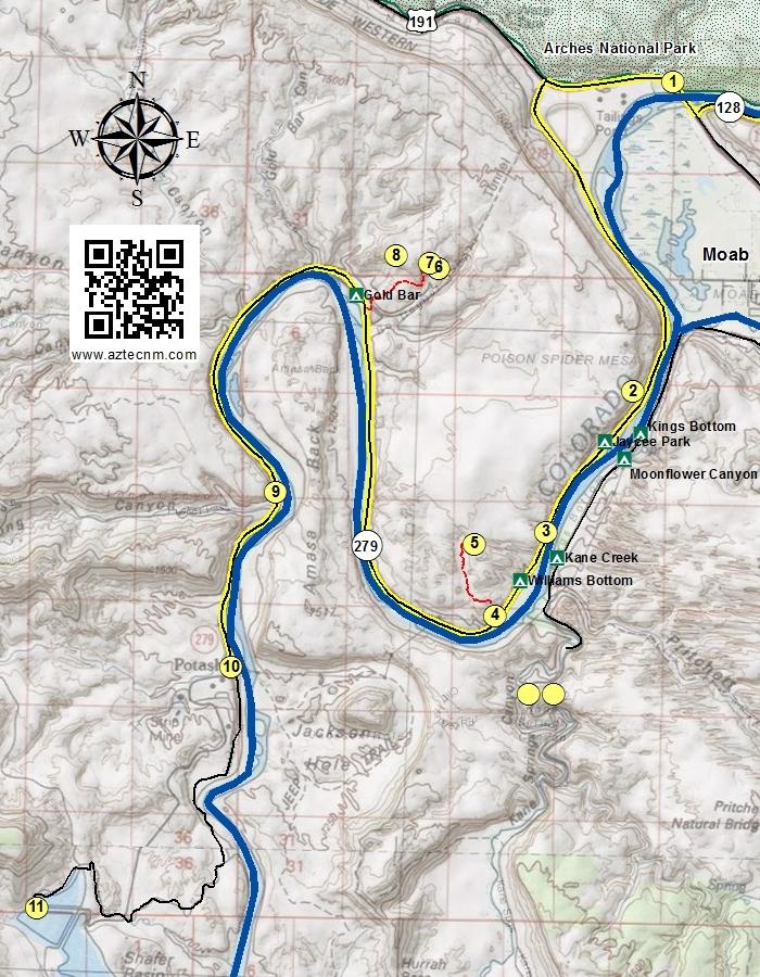
2 Lower Colorado River (UT 279) The Lower Colorado River Scenic Byway follows Utah State Hwy 279 from Moab to the Intrepid Potash Mine, approximately 15.0 miles along the Colorado River. 1. Courthouse Wash Rock Art Located just north of the intersection of UT 128 and US 191, is a place to park and walk along the bike path to Courthouse Wash Rock Art. 2. Little Arch A small arch located on the west side of the highway. Not easily visible unless one takes the 4x4 Poison Spider Mesa Trail. 3. Potash Petroglyphs Several petroglyph panels are located along the cliff side. Signage and areas to pull off the highway are available for viewing the petroglyphs. 4. Poison Spider Dinosaur Tracks and Rock Art This location provides a vault toilet and an informational kiosk providing trail information to the Poison Spider Dinosaur Tracksite, Rock Art, and Long Bow Arch trails. There are two slabs that have dinosaur tracks. The tracks are from Eubrontes and Grallator meat-eating dinosaurs that existed ~190 million years ago in the Jurassic Period. Along the base of the cliff are several panels of petroglyphs. The petroglyphs are of Fremont style and consist of anthromorphs and various quadroped animals such as big horn sheep and deer. One of the panels seems to be depicting a hunt. 2


3 5. Longbow Arch Accessible by an approximate 1.2 mile hike (one-way) from the Poison Spider Trail parking area. The trail the arch is well marked with green dot/dash spots and foot trail through the sandy drainages. Long Bow Arch is approximately 50 ft high with a span of 110 ft. 6. Corona Arch Located in Bootlegger Canyon, Corona Arch is an old buttress arch formed in the Navajo sandstone formation. The arch spans 140 feet with a height of 105 feet. The trail is approximately 2.5 miles round trip from the parking lot to Corona Arch. This arch provides for many photographic aspects depending upon the time of day and direction. At a certain angle, one can see the Eototo (Hopi Chief Kachina) peer out through the arch. 7. Bowtie Arch Located on the same trail to Corona Arch, it can often be photographed with Corona Arch at the ladder and Moki steps along the trail. 8. Pinto Arch (aka Gold Bar Arch) Located north of the Corona Trail, access to this arch requires some rock climbing as it is not easily accessible. 3
 Early in 1961, Texas Gulf Sulpher Company, the original owners of the Cane Creek Potash Mine (located just west of this marker), contracted Harrison")
 ore thousands of feet below the surface, On August 27, 1963, at 4;40 PM, a devastating methane gas explosion occurred")
4 9. Jug Handle Arch Located adjacent to the highway just before the Intrepid Potash Mine. 10. Cane Creek Mine Memorial (Information from the Memorial Plaque) Early in 1961, Texas Gulf Sulpher Company, the original owners of the Cane Creek Potash Mine (located just west of this marker), contracted Harrison International, Inc. to sink the shaft and develop the underground mine to access sylvite (potash) ore thousands of feet below the surface, On August 27, 1963, at 4;40 PM, a devastating methane gas explosion occurred nearly 3,000 feet below in the mine. At the time of the explosion twenty-five Miners were working underground, Eighteen of those miners were killed, either outright from the blast or by smoke inhalation. Ten of the miners initially survived the explosion, As these men headed towards the shaft station to escape they were forced to turn back due to white smoke rolling towards them. The only option was to head to the deepest part of the mine, which was just over 3,000 feet from the shaft station, and construct a barricade. Only seven miners made it to the barricade, After fifteen hours, two of the survivors, Hanna and McKinney, left the barricade and made their way to the shaft station, For several hours they repaired a portion of an airline near the shaft blown out by the blast with the hope that the much needed air would make it back to the men they haft behind in the barricade, After a while, Hanna and McKinney were able to make contact with a rescue team. This team was making their way in an ore bucket clearing a way down through the debris which was stacked up at the bottom of the shaft from the explosion so that following rescue teams could get into the mine and begin the search for survivors. The other five miners behind the barricade were later rescued on August 29, 1963, over fifty-hours after the explosion. In honor and memory of the eighteen miners who 'perished and the seven who survived: Deceased: Wesley J. Barber Robert Wayne Bobo Myrien H. Christensen, Sr. Myrien H. Christensen, Jr. Lawrence L Davidson Jesse E. Fox James N. Hollinger William Huzil Ciell Johnson Jesse C. Kessler Emile J. LeBlanc Kenneth Milton Fred 0, Rowley Joseph Rene Roy Lamar C. Rushton Keith Schear Peter Sviscsu John B. Tinall Survivors: Charles W. Byrge Charles C. Clark 4

5 Grant S. Eslick Donald Blake Hanna Robert E June Paul McKinney Thomas J. Trueman Memorial erected June 2014 by Intrepid Potash, Inc., current owner and operator of the Cane Creek Mine, The underground mine was converted to solution mining in Potash Evaporation Ponds Although not considered as part of the Lower Colorado Scenic Byway, an additional 5 mile trip on a dirt road will take you to an unusual view of strange blue ponds. These man-made ponds are for collecting potash, a potassium-containing salt used in farm fertilizers. A briny solution of salt and water is pumped into deep injection wells. The brine dissolves the potash, leaving other minerals in the rock 2,400 to 4,000 feet underground undisturbed. The mixture of brine, water and dissolved potash is pumped back up into the evaporation pools. The evaporation pools are dyed dark blue to absorb and retain heat from the sun. In the dry desert climate, it takes about 300 days for the brine to dry into salt and potash crystals. The potash mines here were originally by the Texas Sulphur Company in At the time, it was a conventional mine, where workers and machines dug underground. But that same year, a horrific gas explosion trapped 25 men underground, killing 18 of them. A few years later the mine was converted so that manned underground mining was not necessary. 5
6 BLM Campgrounds Moab Field Office 82 East Dogwood Moab, UT (435) Gold Bar Group Site There are 9 individual campsites available on a first come-first serve basis. Campsites include fire grate, picnic table, and vault toilets. The recreation site also includes 4 group campsites that must be reserved on recreation.gov. Group areas have fire grates, picnic tables, vault toilets and sites A, B, and C have shade shelters. Site D does not have a shade shelter. Jaycee Park Picnic and Campground Shady walk-in tent sites near the popular Wall Street climbing area. Individual sites are available on a first-come, first-served basis. Walkin sites only (no trailers, RVs or large vehicles). Sites: 7 Toilets: No Kane Creek Campground & RV Park Privately owned and operated. Group, Individual, and RV Sites Primitive and Hookups Kings Bottom Individual sites are available on a first-come, first-served basis. The campground accommodates tents and small RVs only. Eleven of the sites are walk-in only tent sites. Sites: 21 Toilets: Yes Moonflower Canyon Group Site Group tent site only. Site has fire grates, picnic tables, vault toilet and a shade shelter. No RVs, tent trailers or campers/camper vans allowed. Sites: 1 (max 25 people) Toilets: Yes Dump Station: No Williams Bottom Individual sites are available on a first-come, first-served basis. The campground is located between the Wall Street climbing area and the Poison Spider 4WD trailhead. 6 Sites: 17 Toilets: Yes
7 7
MOAB peopleforbikes.org/e-bikes
 emtb ADVENTURE MAPS MOAB peopleforbikes.org/e-bikes OVERVIEW Moab, Utah is a world-class mountain bike destination known for its vast, red sandstone landscapes nestled below the rising peaks of the La
SIMON CANYON AREA OF CRITICAL ENVIRONMENTAL CONCERN (ACEC)
") SIMON CANYON AREA OF CRITICAL ENVIRONMENTAL CONCERN (ACEC) Activities: Facilities: Season / Hours: Description: Hiking, backpacking, fishing, picnicking, watchable wildlife. A graveled parking area, picnic
SIMON CANYON AREA OF CRITICAL ENVIRONMENTAL CONCERN (ACEC) Activities: Facilities: Season / Hours: Description: Hiking, backpacking, fishing, picnicking, watchable wildlife. A graveled parking area, picnic
Hole in the Rock Scenic Backway
 Hole in the Rock Scenic Backway The Hole in the Rock Scenic Backway leads one along the pioneer path created by a Mormon Expedition. Approximately 55 miles one-way from Highway 12 to the Hole-inthe-Rock,
UTAH 2016 CANYONLANDS
 UTAH 2016 CANYONLANDS THE WHITE RIM TRAIL MAY 17, 2016 We left the cabin at 7:30 a.m. The goal was to get to Great Basin National Park that night. We took Highway 6 towards Tonopah and decided to go north
CONTENTS. 31 THE TRAILS See next page for a complete listing of all trails and a locator map. Trail descriptions begin on page 31.
 CONTENTS Page Topic 6 Trail List 7 Trail Locator Map 8 Trails Listed by Dificulty 9 Trail Ratings Deined 11 INTRODUCTION 11 Using this Book 12 The Right Trail for You 13 About Moab 15 Utah OHV Laws and
Arches of the. Sandflats Area. By Virginia Allen
 Arches of the Sandflats Area By Virginia Allen TABLE OF CONTENTS Introduction Dedication Road Log Arches 1. Perforated View Arch 2. Fee Booth Arch 3. Windsong Arch 4. Weird Arch 5. Resting Arch 6. Bike
NATIONAL ATV / UTV JAMBOREE RIDES
 NATIONAL ATV / UTV JAMBOREE RIDES Note: Rides range from Beginner to Advanced and will last from 2 to 3 hours or an entire day of riding. 1. DESERT RIDE (CLEAR LAKE BIRD REFUGE & LACE CURTAINS/LAVA TUBES)
ANGEL PEAK SCENIC AREA
 Activities: Facilities: ANGEL PEAK SCENIC AREA Hiking, photography, watchable wildlife, camping, picnicking. Note: While formal hiking trails in the area are limited, dispersed hiking opportunities abound
Death Valley Is a Beautiful but Dangerous Place
 Death Valley Is a Beautiful but Dangerous Place Welcome to This Is America with VOA Learning English. Today we visit one of America s great national parks. It is a place of strange and silent beauty. As
Dumont Dunes Special Recreation Management Area (SRMA)
") Dumont Dunes Special Recreation Management Area (SRMA) RMA/RECREATION MANAGEMENT ZONE (RMZ) OBJECTIVE(S) DECISIONS Objective Statement: Designate this area as a Special Recreation Management Area. To manage
Dumont Dunes Special Recreation Management Area (SRMA) RMA/RECREATION MANAGEMENT ZONE (RMZ) OBJECTIVE(S) DECISIONS Objective Statement: Designate this area as a Special Recreation Management Area. To manage
Bureau of Land Management Public Lands Guide Northwest District
 Bureau of Land Management Public Lands Guide Northwest District NORTHWEST Fee Site Restrooms Picnic Sites Developed Campgrounds Farmington Field Office (505) 564-7600 Alien Run Mountain Bike Trail Angel
Zion National Park/Gooseberry Weekend
 WATCH THE VIDEO Zion National Park/Gooseberry Weekend LENGTH: 3 Days / 2 Nights ACCOMMODATIONS: Camping FITNESS LEVEL: Intermediate For up-to-date pricing and dates, please visit our website. This fun-filled
Bryce Canyon Country.
 Bryce Canyon Country Backways Itinerary - Grand Staircase, Capitol Reef Region Grand Staircase/Capitol Reef/Henry Mountains Adventure off the beaten path and revel in the beauty of Utah s scenic backways.
Colorado RV Parks and Colorado Campgrounds. Black Bear RV Park- Resort & Campground. Amenities
 1 Colorado RV Parks and Colorado Campgrounds Black Bear RV Park- Resort & Campground Brief Description: Located at the Arkansas River in Howard, Coloroado Black Bear RV Park is an "ALL-IN-ONE" Rv Park
Best of the Southwest - National Geographic Sweepstakes
 SAMPLE ITINERARY Friday June 15th, 2018 - Friday June 22nd, 2018 Best of the Southwest - National Geographic Sweepstakes Program Meals Friday June 15th Saturday June 16th Sunday June 17th Day 1: Arrive
Internet TripTik. From : Zion National Park, Ut Stop At Stop At Stop At Stop At Stop At. : Bryce Canyon National Park, Ut : Arches National Park, Ut
 MAP: Overview Internet TripTik From : Zion National Stop At Stop At Stop At Stop At Stop At To : Bryce Canyon National Park, Ut : Arches National : Canyonlands National : Monument Valley, Utah : Kayenta,
Crystal Lake Area Trails
 Lake Area Trails Welcome to the Lake area of the Big Snowy Mountains! This island mountain range in central Montana features peaks reaching to 8,600 feet and long, high ridges from which vistas of the
Summary of Recreation Sites Development Name:
 Development Name: Eau Pleine Site Number: 1 Owner: WVIC Eau Pleine Tailwater Boat Launch Lanes 1 Concrete plank landing, access to Eau Pleine tailwater & Lake DuBay. (45 planks long, 62.5') Picnic Tables
20-Day Southwest American Adventure
 20-Day Southwest American Adventure The Southwest region of the United States is one that captivates so many adventurers hearts. Can you imagine yourself a homesteader crossing this vast land and coming
Below is the section of the Byway discussed in the Wise County meeting. Primary coal sites are noted on the map.
 APPENDIX H: PUBLIC PARTICIPATION SERIES OF MEETINGS Virginia Coal Heritage Trail Corridor Management Plan Meeting In Big Stone Gap on the Wise County portion of the Norton Loop September 20 th 2010 at
PROPOSED PROGRAM ITINERARY: (refinements may occur after the field trip pre-run) NORTHEAST ARIZONA
 NORTHEAST ARIZONA") ABF FIELD TRIP LEADER: Paul Remeika ABF TOUR COORDINATOR: Joan Carskaddan MEMBERS ONLY TOUR PRICE $1795/Person, Singles Add $350 PROPOSED PROGRAM ITINERARY: (refinements may occur after the field trip
ABF FIELD TRIP LEADER: Paul Remeika ABF TOUR COORDINATOR: Joan Carskaddan MEMBERS ONLY TOUR PRICE $1795/Person, Singles Add $350 PROPOSED PROGRAM ITINERARY: (refinements may occur after the field trip
National Parks and Beyond
 National Parks and Beyond Canyons, Mesas and Hoodoos Nevada Utah Arizona Red Rock Canyon National Conservation Area Las Vegas, Nevada Begin your adventure under the neon lights of Las Vegas, an oasis in
DESERT SOLITAIRE. Pinnaclemag.com
 DESERT SOLITAIRE Inconvenient and remote, Moab, Utah is an oft-overlooked gem for true wilderness enthusiasts. Despite its renowned Slickrock Trail and its close proximity to two national parks, Moab remains
UTAH S NATIONAL PARK TOUR
 UTAH S NATIONAL PARK TOUR DAY 1 Each client needs to check in any time at the fabulous Aria Hotel located in the heart of Las Vegas. We will meet at 6pm for a one hour orientation explaining the schedule
Children's Discovery Trail Guide - Lost Creek
 Children's Discovery Trail Guide - Lost Creek Thank you for spending time learning and observing some of the secrets of Red Rock Canyon Conservation Area has to offer. Feel free to talk to a ranger if
Dinosaurs and Deserts Loop
 PROOF ROAD TRIPS DINOSAURS & DESERTS SALT LAKE CITY TO ROCKY MOU NTAI N NATIONAL PAR K AN D BACK 1,140 miles G R E AT S A LT LAKE Flaming Gorge National Recreation Area 80 WYOMING 80 Vernal 15 Provo 40
Durango. Durango Whitewater Park
 High Adventure Along Colorado s Million Dollar Highway Durango If you re looking for a multi-day trip of Jaw-dropping adventure in the Colorado mountains look no further! This guide outlays 4 days through
AOTA ArtTrek Locations
 AOTA ArtTrek Locations ArtTrek is a summer-long Grand County, CO art adventure. Highlighted by snow-covered mountain vistas and rolling meadows threaded with sparkling streams and rivers, numerous sites
Group similar facilities together separate dissimilar facilities.
 Park design Principle #1 Group similar facilities together separate dissimilar facilities. Why do we do this? Safety Differences in admission fees Differences in seasonal use Reduce user conflicts Principle
Bryce Canyon Country ATV Multi-Day Itinerary
 Bryce Canyon Country ATV Multi-Day Itinerary Look for more trail information and maps on these web-sites listed below. www. Casto Canyon Kick off your ATV adventure with this 36 mile round-trip ride through
SDTrucksprings. Arkansas Off-roading/4x4 Guide Copyright 2015 We Specialize In:
 SDTrucksprings Arkansas Off-roading/4x4 Guide Copyright 2015 We Specialize In: Helper Springs Air Bags Leaf Springs Body Lift Kits Coil Springs Timbren Kits Hellwig Springs Lift Blocks And More! Visit
Bell s Travel Guides
 Bell s Travel Guides Top of the World Highway Road Log Mile by Mile Description of the Top of the World Highway so you always know what lies ahead. Dawson City, Yukon to Tetlin Junction on the Alaska Highway
SAXON HARBOR REDEVELOPMENT SURVEY
 SAXON HARBOR REDEVELOPMENT SURVEY SEPTEMBER, 2016 1,173 RESPONSES 1 BACKGROUND 1. WHAT TYPES OF ACTIVITIES DO YOU ENGAGE IN AT SAXON HARBOR Sightseeing Swimming Picnicing Fishing Camping Photography Motorized
Camping (Primitive) Camping (RV) Electrical Potable Water Grill Established Fire Pit Picnic Table
 Camping (RV) Electrical Potable Water Grill Established Fire Pit Picnic Table") Alden - 9th Road River Mile 777 Map: 38.20833, -98.32031 Managing Agency: Kansas Department of Wildlife, Parks & Tourism Nearest Community: Alden, Rice County Kansas Developed Amenities Provided Parking
Alden - 9th Road River Mile 777 Map: 38.20833, -98.32031 Managing Agency: Kansas Department of Wildlife, Parks & Tourism Nearest Community: Alden, Rice County Kansas Developed Amenities Provided Parking
Around Page, Arizona and Southeastern Utah (U17A Part 1)
") Around Page, Arizona and Southeastern Utah (U17A Part 1) For a two-week hiking and sightseeing trip centered on Utah and the Colorado Plateau area, I began with repeat stays in Page, Arizona and Monticello,
Around Page, Arizona and Southeastern Utah (U17A Part 1) For a two-week hiking and sightseeing trip centered on Utah and the Colorado Plateau area, I began with repeat stays in Page, Arizona and Monticello,
Jasper National Park of Canada
 Jasper National Park of Canada Things you should know regarding Wabasso, Wapiti, Whistlers and Pocahontas Campgrounds Updated January 2, 2018 Important Notices: Important Notices General Camping Information
National Parks Map & Guide Utah.com: Grand Canyon, Zion, Bryce Canyon, Arches, Canyonlands, Mesa Verde, Capitol Reef, And Great Basin By Utah.
 National Parks Map & Guide Utah.com: Grand Canyon, Zion, Bryce Canyon, Arches, Canyonlands, Mesa Verde, Capitol Reef, And Great Basin By Utah.com READ ONLINE If looking for a ebook by Utah.com National
Ohio RV Parks and Campgrounds. Shadow Lake RV Park. Loveberrys Funny Farm Campgound. Amenities
 1 Ohio RV Parks and Campgrounds Shadow Lake RV Park Brief Description: If you are looking for a park off the beaten path, out in the middle of nowhere then we are it. Settled within the rolling hills of
Our Baker s Peak adventure started in September of 1998 when Bob Dickey, the previous owner of tract #85, signed on the dotted line and 35.
 This is the view from our porch cabin at Baker s Peak. The picture was taken in May (2001 as I recall). With all due respect to the late John Denver, this is almost heaven.! 1 Our Baker s Peak adventure
The gorges of Mohican Park in Ohio create a hiker's paradise Sunday, May 22, 2011 By Bob Downing, Akron Beacon Journal
 Pittsburgh Post-Gazette The gorges of Mohican Park in Ohio create a hiker's paradise Sunday, May 22, 2011 By Bob Downing, Akron Beacon Journal Bob Downing Big Lyons Falls drops 80 feet into a shady U-shaped
Santa Clara South Hills Recreation Park Project Development and Management Plan
 Santa Clara South Hills Recreation Park Project Application for Land for Recreation or Public Purposes, City of Santa Clara, Utah Prepared for: Bureau of Land Management, St. George Field Office 345 East
Your Guide to Mountainbiking around Atlin (yes, you can hike these trails as well)
") Your Guide to Mountainbiking around Atlin (yes, you can hike these trails as well) Foreword Thanks to the rich mining history in Atlin, the historic mining roads have become the perfect trails for recreational
Your Guide to Mountainbiking around Atlin (yes, you can hike these trails as well) Foreword Thanks to the rich mining history in Atlin, the historic mining roads have become the perfect trails for recreational
South Dakota RV Parks and Campgrounds
 1 South Dakota RV Parks and Campgrounds Three Flags RV Park and Camp Brief Description: Large pull thru RV sites 30' wide by 80' long. Park offers coin laundry, free cable TV with full hookups, free WiFi,
BRYCE CANYON COUNTRY Boulder Mountain Scenic backways itinerary
 BRYCE CANYON COUNTRY Boulder Mountain Scenic backways itinerary Boulder Mountain Area The high plateaus of the Aquarius Plateau (Boulder Mountain), are heavily forested and covered in countless winding
BRYCE CANYON COUNTRY. A twisted tree endures rugged life on the rim of the Paunsaugunt Plateau.
 BRYCE CANYON COUNTRY Grand Staircase - Paunsaugunt Plateau Scenic backways itinerary A twisted tree endures rugged life on the rim of the Paunsaugunt Plateau. Travel to Bryce Canyon Country. Lodging check-in,
Beaver Country Trails ATV Jamboree
 Beaver Country Trails ATV Jamboree #1 Lincoln Mine Intermediate (Open to all ATVs/UTVs) 34 Miles Highlights: This ride will highlight the historic Lincoln Mining District, the first lead mine in Utah,
Additional Sources for Camping Information
 Camping Additional Sources for Camping Information 100 pages Day hikes Fourteeners Weekend camping Extended Activities High Adventure Camps Council Camps Cross Country Skiing 40 pages Helpful Tools Colorado
ITINERARY OUTLINE FOR BESPOKE TRIPS
 TREK GRAND CANYON 1 ITINERARY OUTLINE FOR BESPOKE TRIPS DAY 1 DEPART / ARRIVE LAS VEGAS We arrive into Las Vegas and transfer 30 minutes directly to our Boulder City hotel with our local team. This evening
System Group Meeting #1. March 2014
 System Group Meeting #1 March 2014 Meeting #1 Outcomes 1. Understand Your Role 2. List of Revisions to Existing Conditions 3. Information Sources Study Area The Purpose of Mountain Accord is to Preserve
Warming-up. 1. hiking /ˈhaɪ.kɪŋ/ [noun] 2. canoe /kəˈnuː/ [noun] 3. incredible /ɪnˈkred.ə.bəl/ [adjective] 4. guarantee /ˌɡær.
![Warming-up. 1. hiking /ˈhaɪ.kɪŋ/ [noun] 2. canoe /kəˈnuː/ [noun] 3. incredible /ɪnˈkred.ə.bəl/ [adjective] 4. guarantee /ˌɡær.](/thumbs/77/75499037.jpg "Warming-up. 1. hiking /ˈhaɪ.kɪŋ/ [noun] 2. canoe /kəˈnuː/ [noun] 3. incredible /ɪnˈkred.ə.bəl/ [adjective] 4. guarantee /ˌɡær.") Warming-up Learn and Talk II 1. hiking /ˈhaɪ.kɪŋ/ [noun] the activity of going for long walks in the countryside 2. canoe /kəˈnuː/ [noun] a small light narrow boat, pointed at both ends and moved using
Warming-up Learn and Talk II 1. hiking /ˈhaɪ.kɪŋ/ [noun] the activity of going for long walks in the countryside 2. canoe /kəˈnuː/ [noun] a small light narrow boat, pointed at both ends and moved using
1900 S 2800 W. 28 Spaces $499,000. Vernal, UT Outlaw Country RV Resort. For more information: Outlaw County RV Resort - Vernal, UT
 FOR SALE 28 Spaces Outlaw Country RV Resort 1900 S 2800 W Vernal, UT 84078 Property Features ACRES 19.38± 28 operable spaces Rent is $400 / Month Plenty of open space surrounding park for potential expansion
TENKILLER STATE PARK -An Overview-
 TENKILLER STATE PARK -An Overview- - 0 - TENKILLER STATE PARK Region: Northeast (Green Country) Cherokee & Sequoyah Counties CONTENTS General Information. 2 Addresses Driving Directions Phone Numbers Email
South Dakota RV Parks and Campgrounds. Three Flags RV Park and Camp. Hills RV Park BROKEN ARROW CAMPGROUND. Amenities
 1 South Dakota RV Parks and Campgrounds Three Flags RV Park and Camp Brief Description: Large pull thru RV sites 30' wide by 80' long. Park offers coin laundry, free cable TV with full hookups, free WiFi,
Western Lakes & Mountains
 Scenic Long Lake KEVIN SHIELDS REGION 2 Western Lakes & Mountains MAINE S WESTERN LAKES AND MOUNTAINS Region is truly a four-season destination. Not only is the region close, its one hour from the Portland
Waterton Lakes National Park of Canada
 Waterton Lakes National Park of Canada Things you should know regarding Townsite Campground Updated September 11, 2017 Important Notices: Important Notices General Camping Information Fees If There is
Carlsbad Caverns & Ruidoso, New Mexico. September 30 October
 Carlsbad Caverns & Ruidoso, New Mexico September 30 October 8 2016 Sitting Bull Falls, NM Sitting Bull Falls is located in the Lincoln National Forest about 30 miles from Carlsbad, NM. The falls are a
East Carolina Council Facility Study East Carolina Scout Reservation Camp Boddie Pamlico Sea Base
 East Carolina Council Facility Study East Carolina Scout Reservation Camp Boddie Pamlico Sea Base 1 VISION OF CAMP BODDIE EAST CAROLINA SCOUT RESERVATION 1. Attract Out Of Council Troops Use our natural
Lewis and Clark Recreation Area
 Lewis and Clark Recreation Area Bicycle/Pedestrian Trail Also part of the Pierson Ranch Recreation Area trail Type of trail: Walking, biking and rollerblading Trail surface: Asphalt Rated: Mostly flat.
CHAPTER VII: ASSETS, AMENITIES AND UNIQUE OFFERINGS
 CHAPTER VII Other Assets, Amenities, and Unique Offerings in the Tri- City Area The Tri- City area of Cumberland, Benham, and Lynch has numerous unique offerings that, in themselves, are major draws to
U.S. National Forest Campground Guide
 U.S. National Forest Campground Guide Southwestern Region Arizona, New Mexico, Oklahoma and Texas National Forests and Grasslands in the Southwestern Region NF = National Forest NG = National Grassland
Auto-Walking Tour of Osage Hills State Park s Historic Structures
 Auto-Walking Tour of Osage Hills State Park s Historic Structures A guide to some of Osage Hills State Park s distinctive and important historic structures. Introduction President Franklin Roosevelt s
UTAH. Patti Denny Manager Travel Trade Program
 Utah Office of tourism Council Hall/Capitol Hill 300 North State Street Salt Lake City, UT 841114 Tel. 801 538 1318 Fax. 801 438 1399 www.visitutah.com Patti Denny Manager Travel Trade Program Email: pdenny@utah.gov
San Juan Hut Systems Durango to Moab Route Description
 San Juan Hut Systems Durango to Moab Route Description Adventure Without The Weight Using the Daily Route Description: Due to varying calibrations in odometer, riders may notice some inaccuracies in the
Meadow Jamerman Sweetwater
 Meadow Jamerman Sweetwater Campground Layout Sixth Crossing North Entrance Road Meadow Camp Road to Flagg Ranch & Bus Parking Irrigation Ditch Handcart Corral Host Cabin Cattle Guards Jamerman Camp Well
2016/17 Alberta Parks Capital Programs
 2016/17 Alberta s Capital Programs Capital Maintenance and Renewal (CMR) Major Projects Region Description Central Blackfoot/Cooking Lake Provincial Trail System Upgrade Central Jarvis Bay Upgrade Central
Other Agencies and Organizations
 Daniel Boone National Forest 1700 Bypass Road WInchester, KY 40391 859-745-3100 Location Northern terminus is near Morehead, Kentucky. Southern terminus is located in the Big South Fork NRRA in Tennessee.
RUBY AND HORSETHIEF CANYONS - COLORADO RIVER
 RUBY AND HORSETHIEF CANYONS - COLORADO RIVER Rating: Class II CFS Range: 1,000-30,000 Length: 1-3 days Gear: Standard paddling gear, bug spray in the summer. Maps: Mack, CO; Ruby Canyon, CO; Bitter Creek
JR LIVESTOCK CAMPING Available Areas
 JR LIVESTOCK CAMPING 2018 EARLY MOVE-IN IS ON SATURDAY, April 28, 2018 THERE WILL BE NO ADMITTANCE PRIOR TO 7AM. ALL GATES WILL BE LOCKED! (Refer to early move-in section in this letter for more information)
Southwest Family Adventure. 7 Days
 Southwest Family Adventure 7 Days Southwest Family Adventure See three amazing National Parks Grand Canyon, Bryce, and Zion on this epic camping trip designed with families in mind. Every day offers magnificent
Conaway Ranch in Rainbow Canyon Former Golf Course /- Acres with 294 AFA of Water Rights
 Conaway Ranch in Rainbow Canyon Former Golf Course - 244.38 +/- Acres with 294 AFA of Water Rights Rainbow Canyon Rainbow Canyon is named for its spectacular multi-colored rock walls. Meadow Valley Wash,
Steer Creek Campground Corral
 Steer Creek Campground Corral Purpose and Need The purpose of this project is to increase the availability of camping experiences and services for equestrians at the Steer Creek Campground in the Samuel
ELEPHANT BUTTE LAND 640 Acres of pristine land surrounded by BLM property Next to Coral Pink Sand Dune Area Southern Utah INVESTMENT OFFERING
 640 Acres of pristine land surrounded by BLM property Next to Coral Pink Sand Dune Area Southern Utah PROPERTY DESCRIPTION Nestled within one of Southern Utah s picturesque red cliff valleys, with spectacular
BryceCanyon Country. Destination Vacation Itinerary.
 BryceCanyon Country Destination Vacation Itinerary Thisisanitinerarythatoutlinesasix-dayvacationexperienceintheBryceCanyon Countryarea.Theitinerarybeginsonthewestandconcludesonthenorthwest endofscenicbyway12,butcanbeadjustedtosuitanytravelplans.
Central Overland Trail Utah & Nevada Driving Guide, First Edition, 2016
 Central Overland Trail Utah & Nevada Driving Guide, First Edition, 2016 Page 51 In the third paragraph, second sentence, change 0.4 miles to 0.1 miles. In the fourth paragraph, second sentence, change
MOAB Multi-Day (update ) RUN ANNOUNCEMENT
 RUN ANNOUNCEMENT") MOAB Multi-Day (update 02-06-18) RUN ANNOUNCEMENT RUN FULL NO MORE RSVPs ACCEPTED Date: March 31st to April 6th 2018 Trail Leader: Mike Wallace (714) 504-8514 Max Vehicle Limit Reached Meeting Tims: To
MOAB Multi-Day (update 02-06-18) RUN ANNOUNCEMENT RUN FULL NO MORE RSVPs ACCEPTED Date: March 31st to April 6th 2018 Trail Leader: Mike Wallace (714) 504-8514 Max Vehicle Limit Reached Meeting Tims: To
The Ultimate Retreat- A Blissful Journey GRAND CANYON, USA. September 20-29, 2017 with Yoga Master Ulrica Norberg
 The Ultimate Retreat- A Blissful Journey GRAND CANYON, USA September 20-29, 2017 with Yoga Master Ulrica Norberg This is a once in a liftetime retreat. What you embark on is a soulful journey into the
Raindrops Keep Falling On Peel
 Raindrops Keep Falling On Peel Activity Overview: A large map of Peel Region is created in an obstacle course type fashion. The Activity Operators will lead the students on a tour as if they were raindrops
NEWFOUNDLAND RV PARKS & CAMPGROUNDS RECOMMENDED BY THE NRVOA
 NEWFOUNDLAND RV PARKS & CAMPGROUNDS RECOMMENDED BY THE NRVOA Newfoundland Newfoundland and Labrador is almost three times the size of New Brunswick, Nova Scotia and Prince Edward Island combined, and is
Coyote Gulch, Glen Canyon National Recreation Area, Utah, Spring Break 2009
 Coyote Gulch, Glen Canyon National Recreation Area, Utah, Spring Break 2009 This year, Jen and I decided to revive a tradition begun in our early years together: a yearly Spring Break trip to southern
Bradshaw Trails Series
 Bradshaw Trails Series Curtis James Troop 7014 Curtis.James@erau.edu My Motto: Never get lost! Hiking Rules Bradshaw Hiking Patch Series Hiking Tools Hiking Rules Hiking Merit Badge* Take five 10-mile
Trail Phasing Plan. Note: Trails in the Clear Creek Canyon area (Segments will be finalized in the future to minimize wildlife impacts
 Note: Trails in the Clear Creek Canyon area (Segments 2 5 and a future JCOS connection) will be finalized in the future to minimize wildlife impacts Trail Phasing Plan P Parking 3 Easy Trail Intermediate
Maya s Creek Crossing Hwy 17 N acres $185,000 Fort Davis, Texas
 Maya s Creek Crossing Hwy 17 N 14.98 acres $185,000 Fort Davis, Texas James King, Agent Office 432-426-2024 Cell 432-386-2821 James@KingLandWater.com King Land & Water LLC P.O. Box 109, 600 State Street,
Central Texas. Country Clubs & Resorts
 Central Texas Country Clubs & Resorts Central Texas Country Clubs and Resorts 5 2 46 25 20 9 28 6 27 Ranch Rd. 2 7 6 Ranch Rd. 2 620 26 7 2 3 23 24 826 3 8 8 3 620 2222 0 2 5 4 9 4 2 22 95 95 The country
Welcome Session A4- Tourism Trends: Best Practices for RV Parks and Campgrounds Tuesday, September 18, :45pm - 3:15pm
 Welcome Session A4- Tourism Trends: Best Practices for RV Parks and Campgrounds Tuesday, September 18, 2018 1:45pm - 3:15pm To receive a Certificate of Completion, please provide information requested
top trails of utah includes zion bryce capitol reef canyon lands arches grand staircase coral pink sand dunes goblin valley and glen canyon
 DOWNLOAD OR READ : TOP TRAILS OF UTAH INCLUDES ZION BRYCE CAPITOL REEF CANYON LANDS ARCHES GRAND STAIRCASE CORAL PINK SAND DUNES GOBLIN VALLEY AND GLEN CANYON PDF EBOOK EPUB MOBI Page 1 Page 2 coral pink
Maine RV Parks and Campgrounds
 1 Maine RV Parks and Campgrounds Wilderness Edge Campground Brief Description: We are located in the heart of Moose country just minutes from Baxter State Park, Mt. Katahdin, and The Katahdin Woods & Waters
Prince Edward Island National Park of Canada
 Prince Edward Island National Park of Canada Things you should know regarding Cavendish and Stanhope Campgrounds Updated October 20, 2017 Important Notices: Important Notices General Camping Information
Eagle Scout Project Improves the Trail
 Happy Hoofers Hoopla Volume 25, Issue 3 www.hoofers.floridatrail.org 1-877-HIKE-FLA Inside this Issue 1 2 3 5 7 Eagle Scout Project Memorial Fern Forest News Chair s Corner Trip out West, part 3 Upcoming
Draft Business Plan for BLM Monticello Field Office Campgrounds
 Draft Business Plan for BLM Monticello Field Office Campgrounds U.S. Department of the Interior Bureau of Land Management, Utah Canyon Country District Monticello Field Office July 2015 0 Draft Business
DOWNLOAD OR READ : UTAH CAMPING GUIDE THE ESSENTIAL HANDBOOK FOR PLANNING AND ENJOYING YOUR NEXT OUTDOORS TRIP PDF EBOOK EPUB MOBI
 DOWNLOAD OR READ : UTAH CAMPING GUIDE THE ESSENTIAL HANDBOOK FOR PLANNING AND ENJOYING YOUR NEXT OUTDOORS TRIP PDF EBOOK EPUB MOBI Page 1 Page 2 trip utah camping guide the pdf trip The Back of Beyond
Recreation. All Terrain Vehicles. Bird Watching at Russell Lakes State Wildlife Area. Camping. Fishing
 Recreation All Terrain Vehicles All Terrain Vehicles must be licensed. Check with Forest Service and Bureau of Land Management for rules and regulations and areas where you can ride. 719 655-2547 Bird
Mazatzal Wilderness Trail Maintenance and Exploration
 Mazatzal Wilderness Trail Maintenance and Exploration March 15-19 (Wednesday - Sunday) Difficulty: Beginner Camping: Car Camping Mileage: Wednesday ~4 miles Thursday ~4-6 miles Friday ~4-6 miles Saturday
Where to Stay in Moose Jaw
 Where to Stay in Moose Jaw Offcial Accommodation Guide 2014 Moose Jaw Pride Week Better Together Travelodge Moose Jaw Days Inn Accessible facilities, Air-conditioned, Free Wi-Fi, Free breakfast, Free parking,
Explore some of the country's most amazing red-rock landscapes and soaring granite peaks on this 1,140-mile tour. WYOMING COLORADO. Junction.
 PROOF S A LT L A K E C I T Y T O R O C K Y M O U N TA I N N AT I O N A L P A R K A N D B A C K D I N O S AU R S AND DESERTS LOOP Explore some of the country's most amazing red-rock landscapes and soaring
ROYAL GORGE PARK and RECREATION AREA. A Feat of Natural and Man-Made Engineering
 ROYAL GORGE PARK and RECREATION AREA A Feat of Natural and Man-Made Engineering As Growth Resumed in the 1870 s Town Leaders Began to Envision a Tourist Industry. The Arkansas River Canyon was advertised
Accessible Information Alabaster Caverns State Park
 Alabaster Caverns State Park Park office entrance and main parking lot The Visitor Center Picnic shelter #1 One RV site Comfort station Playground Cavern tours are not recommended for the following persons
This Is the. W e s t
 This Is the W e s t This Is the W e s t Copyright by Harcourt, Inc. All rights reserved. No part of this publication may be reproduced or transmitted in any form or by any means, electronic or mechanical,
Prince Edward Island National Park of Canada
 Prince Edward Island National Park of Canada Things you should know regarding Cavendish and Stanhope Campgrounds Important Notices General Camping Information Fees If There is No Vacancy Require Additional
Hiking Las Vegas.com
 Hike: Mt. Wilson via First Creek Canyon route Trailhead: First Creek marked Distance: 10 miles up and back Elevation gain: 3,400 feet Elevation of Peak: 7,070 feet Time: 7 to 9 hours (up and back) Difficulty:
RECREATION ACCESS AND COMMUNITY ENRICHMENT PLAN
 Template for facilitating Siskiyou County, the City of Yreka and the State of Jefferson in a RECREATION ACCESS AND COMMUNITY ENRICHMENT PLAN Access to the Mountains CREATING ACCESS TO PUBLIC AND PRIVATE