2004 Airport Master Plan Update
|
|
|
- Prudence Wood
- 5 years ago
- Views:
Transcription

1 2004 Airport Master Plan Update December 2004
2 Table of Contents Executive Summary... 5 Purpose of the Master Plan... 5 Airport s Role... 5 Aviation Trends/ Forecasts... 5 Existing Constraints... 6 Airside Constraints... 6 Airport Support... 7 Access to the Airport... 7 Public Awareness... 8 Commercial Development... 8 Sustainable Development Concept... 8 Competitor Airports Noise Impacts Principal Recommendations by Responsible Agency Introduction Airport History Airport Setting Airport Administration Competitive Environment Competitor Airports Strengths / Opportunities Primary Weaknesses / Threats Master Plan Purpose Goals and Objectives Assumptions Site Conditions Location and Ground Access Topography Drainage Environmental Considerations Surrounding Land Use Industrial Business Park Airport Activity Regional Population & Economic Activity Air Transportation Trends Airport Activities / Forecasts Aircraft Movements Passenger Traffic Air Cargo / Courier Traffic General Aviation Hamilton International Airport Page 1 of Master Plan
3 3. 4 Long Range Airport Capacity Analysis Assessment of Existing Facilities Airside Infrastructure Runways Taxiways Aprons Airfield Lighting Visual Aids Instrument Navigation/ Landing Aids Air Terminal Facilities Airport Support Facilities Air Traffic Control Facilities Airport Maintenance Garage Emergency Response Services Aircraft Refueling Facilities Aircraft De-icing Facilities Meteorological Services Landside Access Regional Access Airport Roadways Parking Utilities and Services Sanitary Services Municipal Water Supply Fire Protection System Natural Gas Stormwater Servicing Electrical Service Communication Services Commercial Development Air Cargo/ Courier General Aviation Airport Registered Zoning Strategic Plan Mission Statement Strategic Vision Airport Role Strategic Objectives and Initiatives Objective # Objective # Objective # Objective # Objective # Hamilton International Airport Page 2 of Master Plan
4 6.0 Land Use Plan General Airport Development Concept Airport Planning Considerations Opportunities and Constraints Development Alternatives Airport / Community Interface Noise Impacts Noise Related Conclusions Noise Management Plan Land Use Planning Registered Airport Zoning Landside Access Land Use Descriptions Airside Operations & Reserve Airport Terminal & Reserve Airport Support & Reserve Airside Commercial & Reserve Non-Airside Commercial & Reserve General Commercial Reserve Servicing Sanitary Sewers Water Services Stormwater Drainage Land Acquisition Requirements Implementation / Phasing Environmental Management Environmental Mission Statement Goals and Objectives Environmental Management Practices and Procedures Recommendations Airport / Community Interface Noise Considerations Registered Airport Zoning Land Use Airside Reserve Airport Support Airside Commercial Non-Airside Commercial General Commercial Services Hamilton International Airport Page 3 of Master Plan
5 List of Tables Table 3.1: Regional Population Table 3.2: Historical Aircraft Movements Table 3.3: Aircraft Movement Forecast Table 3.4: Historical Passenger Volumes Table 3.5: Air Cargo Activity Table 4.2: Aircraft Movements / Hour Table 4.3: Summary of Runway Pavements Table 4.4: Heavy Aircraft Currently in Use Table 4.5: Runway Length Requirements Table 4.6: Description of Taxiways Table 4.7: Summary of Apron Pavements Table 4.8: Summary of Airfield Lighting / Visual Aids Table 4.9: Instrument Navigation / Landing Aids Table 4.12: Estimated Hydro Demand Loads Table 6.3: ATB Expansion Phase 1 & Phase 2 Table 6.5: Airport Drainage Studies List of Figures Figure 1.0: Figure 1.1: Figure 2.1: Figure 4.1: Figure 4.10: Figure 4.11: Figure 4.13: Figure 4.14: Figure 6.1A: Figure 6.1B: Figure 6.2: Figure 6.4: Figure 6.6: Figure 6.7: Airport Development Concept Regional Location Location Map Existing Site Plan Existing Air Terminal Building Layout Landside Access Map Existing Airport Registered Zoning Future Airport Registered Zoning General Airport Development Concept Development Concept on Airport Property Airport Influence Areas Future ATB Expansion Development Phasing Airside Development Phasing Appendices Appendix A: TP1247E, Land Use in the Vicinity of Airports, 7 th Edition, 1991 Appendix B: Proposal for a Hamilton International Airport Vicinity Protection Area Appendix C: Hamilton International Airport Noise Impact & Evaluation Study, 1999 Hamilton International Airport Page 4 of Master Plan
6 Executive Summary The John C. Munro Hamilton International Airport (HI) has served the Hamilton region as the primary air transportation facility since it first became a civil airport in The airport is located within the City of Hamilton boundary. On December , the ownership of the airport was transferred from the federal government to the Region of Hamilton-Wentworth. Lacking the expertise to effectively manage the airport on a day-to-day basis the regional government turned to the private sector. Through a competitive process, TradePort International Corporation was selected to undertake responsibility for the management, operation and financing of the airport. TradePort International assumed this responsibility on July 1, 1996 and now operates the airport on behalf of the City of Hamilton through its subsidiary, Hamilton International Airport Limited (HIAL). Since that date TradePort International has improved the facilities at the airport in numerous ways, including the expansion of concrete aprons, taxiway development, hangar development, reservoir development and the international arrivals hall. Purpose of the Master Plan The primary purpose of the Airport Master Plan is to establish an orderly development concept for the Airport, which protects and preserves options for the airport s operation and future development over the next 20 years. The Master plan sets out objectives and recommendations and serves as a guide for sustainable development decisions. The Airport Master Plan also provides a strategic vision for the Airport; this vision can be endorsed by the local community and incorporated into the Official Plans of the City of Hamilton. Airport s Role The airport s primary role is to serve as a regional commercial and general aviation airport capable of providing scheduled and charter passenger services, air cargo and courier activities and corporate / general aviation services. TradePort International Corporation s vision for Hamilton International is predicated on achieving HI s full potential by being: One of Canada s 5 busiest passenger airports; and The #1 air freighter gateway in Canada. Aviation Trends/ Forecasts Hamilton International has clearly demonstrated the market support within a 90 minute driving radius. The rate of passenger growth between 1999 and 2003 has been Hamilton International Airport Page 5 of Master Plan
7 unprecedented amongst Canadian airports, growing from 22,561 passengers in 1999 to 1,041,241 passengers in The market demand in the Hamilton catchment area was tested with the service provided by WestJet in the years 2000 to The ultimate target of establishing approximately five (5) million passengers per annum is an achievable goal. The unfortunate reduction in service by WestJet from the Hamilton market in 2004 will delay this reality until other service providers establish themselves in the market. Passenger movements at Hamilton International have always been tempered by the fact that the region is less than an hour s drive from Lester B. Pearson International Airport and a low public awareness of an international airport in Hamilton. However, with the planned opening of the New Highway 6 link to the 403 in October 2004 and the overwhelming size and complexity of Lester B. Pearson International Airport, the public will soon realize that there is another airport option that provides hassle free service to their community. A new marketing awareness campaign was launched in 2004 to improve awareness of the Airport and the services available. The future growth of Hamilton International is still dependent on: the airport s ability to capture a large portion of its own natural market; the introduction and growth of quality air services; an improved groundside road accessibility to the Airport; and the protection of land and provision of servicing for expansion purposes. In 1999 the airport handled 87,000 metric tonnes of cargo. At present the airport on an annual basis handles over 93,000 tonnes of cargo. It is expected that the airport will continue to foster an environment with its business partners that will allow expansion of this role so as to see courier / cargo activities to exceed 500,000 tonnes by The growth of both cargo and passenger service can be accomplished concurrently. Existing Constraints Hamilton International will require updating of its airside services in order to meet the projected demand that is envisioned. In order to maintain a low cost environment for the airlines serving the airport, shortened departure times are vital. This will eventually require the construction of parallel taxiways, an improved air terminal building with bridged facilities and increased hold room and baggage handling facilities. All of these items create the environment that passengers expect of a modern airport. The introduction of these modernized facilities, however, cannot be provided until the general public commits to support the airlines that serve this catchment area. Airside Constraints A parallel taxiway system will be required to minimize fuel burn and improve the efficiency of air carriers. At present, the existing runway is compromised because aircraft are required to backtrack on the runway in order to access the Hamilton International Airport Page 6 of Master Plan
8 departure thresholds. A Category 2 instrument landing system will be required to ensure that air carriers are able to land and takeoff during low visibility conditions. Runway being the preferred into-wind runway, (especially during poor weather) lacks a precision instrument approach system. Runway will need to be extended and the existing pavement structure will need to be upgraded so as to ensure that large aircraft, such as the B747, can be accommodated. The existing runway has been subject to years of pavement overlays, which were required to maintain its serviceability. However, it is soon time that the underlying drainage, pavement sub base and base course components be replaced. Two thirds of the runway will require a major overhaul in order to improve its pavement load rating. The pavement structure for taxiways Delta, Bravo, Golf and Lima will also need to be addressed to ensure that operational requirements are satisfied Additional cargo stands will be required to facilitate itinerant carriers Aircraft deicing operations are currently undertaken at the gate. It should be understood that a dedicated deicing facility may be required at an alternative location. This ensures the efficient movement of aircraft and the time from deicing completion to takeoff can be kept as short as possible, thus improving air carrier low cost strategy. Other alternatives must also be examined prior to a decision being made on this issue. Airport Support The airport maintenance garage does not have adequate space for storage of vehicles and equipment, administrative functions and parts stores. An expanded facility will be required in the short term to provide these functions. The existing fire hall may require a larger bay to house the acquisition of a larger and newer model of fire truck. The facilities are also in need of general modernization. Access to the Airport With the completion of the New Highway 6 Airport Expressway in the fall of 2004, access to the airport has been greatly improved to and from Highway 403. Construction of the Redhill Creek Corridor will also benefit the airport, however to a lesser degree, as the connection from the QEW does not extend to the airport. An improved access route from the Redhill Creek / Lincoln Alexander Parkway to the Airport is required to complete the ground access requirements to the Airport. Access from the Niagara Region and New York State via a Mid Peninsula Corridor is also under consideration and would decrease travel time to the airport from these Hamilton International Airport Page 7 of Master Plan
9 areas. This new highway corridor would provide a better connection in the future as vehicle traffic in this region continues to grow. There should also be consideration of a future connection to the Golden Horseshoe Light Rail Transit network and other similar public transportation systems in connecting regions. Public Awareness The level of public awareness is fundamental in supporting this airport. This involves not only awareness that there is an international airport in Hamilton but also awareness to what services are provided from the Airport and how those services compare to those offered at Lester B. Pearson International Airport. Commercial Development There currently exists 16.2 hectares of green lands that are available for immediate development within the airport s control. Outlying areas to the north and west are unsuitable due to lack of airside infrastructure, civil infrastructure, transportation access as well as poor terrain. Due to these constrictions, those areas have been designated as medium to very long term development. There currently are no other lands available for development of air cargo / courier facilities to meet both immediate and foreseeable future demand. Sustainable Development Concept The development concept proposed under this Airport Master Plan Update is presented on the following plan. This sustainable concept reflects the existing and forecasted operational and business needs of the airport and provides opportunities for future development. The proposed concept also addresses the constraints that have been identified in this document. The intent of the Airport Master Plan is to set out a development concept that meets the functional and operational needs of the airport, while at the same time, interfaces the airport s land use plan with those of adjacent communities. The development concept proposed under this Airport Master Plan Update is in keeping with the official plans for the City of Hamilton and local communities. Land use components of the Airport Master Plan include: The intent of the Airport Master Plan is to achieve an appropriate interface between the airport and the community. This interface touches upon a number of key elements including noise, land use planning, vehicular traffic, wildlife corridors, agricultural buffers, wetland and forested areas. Airside Operation - Those lands that are currently used or required for the safe movement and operation of aircraft. This includes runways, taxiways, aprons, Hamilton International Airport Page 8 of Master Plan

10
11 navigational aids and lands required for their protection. Airport Terminal Those lands required for the current operation and short-term expansion of the existing passenger terminal facilities, including groundside access and parking facilities. Airport Support - Lands required for airport support functions including airport maintenance, fire hall, and air traffic control tower. Airside Commercial - Lands, which encompass a wide range of activities that require, direct access to airside operational areas. These activities include air carrier, air courier / cargo facilities, aircraft maintenance / storage hangars, flight training, aircraft rental and charter services Non-Airside Commercial - Lands (on or off airport) for commercial and light industrial activities that benefit from their proximity to an airport but do not require direct airside access. Activities include freight warehousing and distribution, flight kitchens, car rental facilities, light manufacturing, hospitality services and office/ retailing. General Commercial Reserve Off-airport lands for commercial activities that are not airport related, but which services are directed to the local community and the services provided at the airport. Airside Operations Reserve - Those on-airport lands, which are not required for the current airside operations but will be required for future expansion, should be identified to protect for future movement and operation of aircraft. This includes runways, taxiways, aprons, navigational aids and the lands required for their protection. It is intended that these lands would remain under an agricultural designation until there is a demonstrated need for their use for airport related purposes Airport Terminal Reserve Those on-airport lands which are not required for immediate terminal use but will be required for future expansion of the passenger terminal facilities should be identified and should include groundside access and parking facilities. Airport Support Reserve Those on-airport lands required for future airport support functions including airport maintenance facilities, fire hall, and air traffic control tower. Off-Airport Development Reserve Those lands outside of the current airport property boundary, but which need to be identified as providing future non-commercial and commercial development opportunities related to the airport. It is intended that these lands would remain under an agricultural designation until there is a demonstrated need for their use for airport related purposes. Hamilton International Airport Page 9 of Master Plan
12 Competitor Airports There are several airports in Ontario, Canada and the U.S.A. which are competing for the same air carrier services as Hamilton International. HI must proceed with expanding our land base to allow the necessary facilities to be built in order to continue to attract additional air carrier services and aircraft on new flight routes. Airports of immediate concern are the Region of Waterloo International Airport, London International, Buffalo International, Toronto Pearson International and the yet to be built Pickering Airport. These airports have the ability to accommodate new commercial developments and either have or will soon have in place modern, air terminal facilities with which to compete. Noise Impacts Recognition must be given to the 24 hour per day window of operation, which has allowed the courier activities at the airport to flourish. The level of nighttime activity associated with these operations dictates a greater sensitivity to minimize the noise impacts on the surrounding communities. As part of the Airport Master Plan, Noise Exposure Forecast (NEF) analysis was undertaken. NEF contours were prepared based on 1996 actual aircraft movements. This analysis was then compared to NEF contours, which were prepared by Transport Canada using 1994 aircraft movement data and with forecasted aircraft movements for the years 2008 and In the analysis, aircraft movements are assumed to grow 3% annually. The analysis concluded that between 1994 and 1996, the overall area impacted by the NEF contours was reduced in area. This was largely the result of reduced number of annual aircraft movements and also because of the increased number of Chapter III aircraft which make use of new engine technologies and which are substantially quieter. NEF contours prepared for 2003 show NEF contours which are substantially smaller that the 1996 contours. Despite the increase in annual aircraft movements, the NEF contours for 2003 have been reduced because of the introduction of Chapter III aircraft. Although aircraft noise will continue to impact the surrounding community, these impacts will generally diminish despite potential increases in the number of movements. The primary reason for this will be the introduction of quieter aircraft. Noise impacts have been further mitigated with the utilization of a Noise Management Plan. The recent implementation of this plan has already helped to reduce the impact of noise on the surrounding community. To minimize future impacts, it is important that the City of Hamilton implement planning policies that restrict residential development and other non-compatible development in the vicinity of the airport. Hamilton International Airport Page 10 of Master Plan
13 Principal Recommendations by Responsible Agency The principal recommendations, as presented in this Master Plan Update, are listed by the responsible agency. It is recommended that the City of Hamilton give consideration to endorsing the proposed Airport Master Plan Update and incorporate the key planning principals, objectives and recommendations into the Official Plan (OP) amendments and GRIDS planning documents, and giving due consideration to any required environmental assessment processes which the City must follow. This process should be completed every 5 years prior to OP amendments; give consideration to undertaking the acquisition of adjoining lands to ensure the protection of future Airport expansion plans; give consideration to undertaking the necessary planning and coordination with the applicable utility companies to ensure that adequate site services to the Airport are provided, including but not limited to potable water, sanitary sewers, hydro, telecommunication lines, natural gas and other utilities as required; give consideration to undertaking to provide a HI Airport Vicinity Protection Area By-Law similar to that in place in Winnipeg; give consideration to providing a direct link between the New Highway 6 airport expressway and the Lincoln Alexander Parkway / Red Hill Creek Expressway intersection to ensure suitable road access for those customers accessing the Airport from the QEW and areas to the east and south-east; continue the development of the Hamilton International Airport Aerotropolis concept and ensure good transportation links exist between the Airport and the surrounding community and other Priority and Emerging Urban Centres; Hamilton International Airport Limited (TradePort International) with the cooperation of the City of Hamilton update federal Airport Registered Zoning and incorporate into the HI Airport Vicinity Protection Area By-Law required to protect existing and future land use at and in the vicinity of the airport; expand the existing terminal building, as passenger traffic demands, to accommodate future passenger growth install a Category 2 Instrument Landing System at the airport thereby providing improved reliability and access for air carrier operations during periods of low visibility; provide airside access to new airside commercial development areas; Hamilton International Airport Page 11 of Master Plan
14 rehabilitate and extend Runway to 2,743 m (9,000 ft.) to accommodate future aircraft operations; Provincial Government incorporate the airport planning principals contained within this Airport Master Plan into future provincial transportation plans and policies. Encourage the incorporation of provincial objectives contained in the Places to Grow strategy paper into the planning and development of the Hamilton International Airport Aerotropolis. Specifically, encourage the following: o development of the Airport as an emerging growth node, o incorporate employment lands within the urban boundary, and o ensure the City of Hamilton has access to infrastructure funding. expedite the construction of the Mid Peninsula Transportation Corridor and continue to develop good transportation links between the Airport node and other Priority / Emerging Urban Centre transportation nodes; participate in increasing public awareness of the Airport facilities and the services provided by the air carriers through the provision of adequate signage; Federal Government encourage the future development and expansion of Hamilton International Airport to maintain role as the main reliever airport to Pearson; provide adequate capital funding towards airport safety-related capital improvement projects. Hamilton International Airport Page 12 of Master Plan
15 1.0 Introduction 1.1 Airport History Flying activities at Hamilton International first began in October 1940 when the airport began operations as an air force training station. Constructed under the British Commonwealth Air Training Plan, the airport was originally laid out in a three runway triangular pattern, typical of the many training airfields that were built as part of the war effort. The original three runways were each 945 meters (3100 ft) in length. In the late 1950 s, with the introduction of jet aircraft into the Royal Canadian Air force, Runways and were extended to 1,828 m (6,000 ft) and 1,524 m (5,000 ft) respectively. Facilities originally constructed for the military included several large hangars and numerous smaller buildings that were used as barracks, administration offices and workshops. With the exception of the hangars and the RCAF club, all of the wartime structures have since been demolished. Military activities continued at the airport until 1963, when the Department of National Defense declared the airport surplus to its needs and the ownership transferred to the federal Department of Transport (Transport Canada). Transport Canada managed the operation of the airport until At that time an agreement was reached with the City of Hamilton whereby the City would assume responsibility for the operation and maintenance of the airport. Under the agreement, the federal government agreed to support the airport s operation through the contribution of a direct subsidy to cover approved operating deficits and capital expansion projects. In the mid s a number of major capital projects were undertaken at the airport. These included the construction of a new 2,438 m Runway 12-30, a new air terminal building, the control tower, and the equipment maintenance garage. With the construction of the new runway, Runway was decommissioned and converted to Taxiway Charlie to provide access to the new Runway from the terminal area. In the mid s the airport experienced further expansion with the development of a number of aviation- related facilities including the Transport Canada Services hangar, hangar facilities for Ontario Flightcraft, the Canadian Warplane Heritage Museum and the UPS courier facility. In July 1994, Transport Canada announced the National Airports Policy (NAP). Under NAP, Transport Canada proceeded to divest itself from the ownership of local and regional airports throughout Canada. On December 20, 1996, the ownership of Hamilton International was transferred to the Regional Municipality of Hamilton- Wentworth. Lacking the expertise to effectively manage the airport on a day-to-day basis, the regional government turned to the private sector. Through a competitive proposal process, TradePort International Corporation was selected to undertake Hamilton International Airport Page 13 of Master Plan
16 responsibility for the management, operation and financing of the airport. TradePort assumed this responsibility on July 1, 1996 and operates the airport today through a wholly owned subsidiary company named Hamilton International Airport Limited. Since then the Airport has seen further capital improvements with the addition of the Purolator sort facility, the Jet Port Hangar, the WestJet Hangar, Taxiway Whiskey, renovations to the International Terminal Building, expansion to the domestic and international arrivals areas, the Apron expansion to the west and to the north, along with an automated parking system for short and long term passengers, car rental and employee parking. In addition, preparation of the sub-grade for a parallel taxiway system commenced at the button of Runway 30. Hamilton International saw its volume increase in 2003 to over one million passengers with the support of Hamilton residents and the local communities. In 2004 the New Highway 6 link to/from Highway 403 will provide improved road access to the Airport. 1.2 Airport Setting The John C. Munro Hamilton International Airport has served the Hamilton region as the primary air transportation facility since it first became a civil airport in The Airport is located in the City of Hamilton. Located immediately, to the southeast of the airport is the Mount Hope Urban Area. The Airport lands are approximately 524 hectares in area and are generally bounded by Dickenson Road to the north, Highway 6 and Homestead Drive to the east, Airport Road to the south and the agricultural lands to the west. The regional location of the airport is illustrated in Figure 1.1. Hamilton International serves as a primary transportation facility for a large geographical area that includes the City of Hamilton, the Regions of Niagara, Haldiman-Norfolk, and the County of Brant. The airport also serves as a secondary airport to the Greater Toronto area and Southern Ontario. 1.3 Airport Administration In 1996, the Regional Municipality of Hamilton-Wentworth entered into an agreement with TradePort International Corporation for the operation and management of the airport. TradePort International Corporation is a consortium of Canadian companies, which includes YVR Airport Services Ltd. (a subsidiary of the Vancouver International Airport Authority), Labourers International Union of North America (LIUNA), and Westpark Developments. As previously mentioned, TradePort operates the airport today through a wholly owned subsidiary company called Hamilton International Airport Limited. 1.4 Competitive Environment The John C. Munro Hamilton International Airport operates in a competitive industry. Recognition of this competitive environment is essential in airport planning. The following analysis of the competitive environment was taken into consideration when developing the master plan recommendations to maximize future competitiveness, and hence future potential, of the airport Hamilton International Airport Page 14 of Master Plan

17
18 1.4.1 Competitor Airports Lester B. Pearson Toronto International Airport Located in Mississauga and operated by the Greater Toronto Airports Authority (GTAA), Pearson International is currently the most significant competitor for passenger and cargo business given its size, proximity to downtown Toronto, and critical mass of connecting worldwide service. However, characteristics of Pearson International, including limited availability of developable airside land, night-time flight restrictions and congestion, create competitive propositions for alternate airports within the region, including Hamilton. Proposed Pickering Airport The proposed Pickering airport is a significant competitor even today many years before construction begins. Development of the Pickering Airport is a mandate of the GTAA, and a major economic objective for Pickering and region. To the degree the GTAA continues to promote and invest in the Pickering Airport, government support and public attention shifts away from the role Hamilton can play within the region. This is extremely important in the context of provincial land use planning and participation in infrastructure funding programs. Once constructed, the GTAA will almost certainly use Pickering Airport to relieve capacity pressure on Pearson International. To the extent Pearson capacity is relieved, Pearson becomes a more serious competitor to Hamilton International. It should also be noted that in the GTAA s Pickering Airport Draft Plan Report, the estimated number of aircraft movements to be relocated to Pickering Airport from Hamilton International Airport is 8,000 annual movements by Although this number seems to be an optimistic estimate by a close competitor, the City of Hamilton should take steps to ensure that its own future growth is not hampered by the development of the Pickering Airport. Region of Waterloo International Airport The Region of Waterloo International Airport is emerging as a significant competitive threat for passenger service and airport related development within the region. Currently the airport serves two domestic locations (Ottawa and Montreal) and Detroit with international connections. In fact, this Airport offers international and USA connections unavailable at Hamilton. Owned by the Region of Waterloo, the airport is extremely aggressive in increasing passenger service and has recently invested nearly $20 million of taxpayer money into a new terminal building and runway extension and the creation of approximately 20 acres of serviced developable land. The master plan for the airport specifies further development over the next several years as traffic continues to build. Toronto City Center Airport Located on the Toronto Islands near downtown Toronto, the City Center Airport is not a significant competitive threat to Hamilton due to runway length and flight restrictions. However, to the extent passenger service develops at City Center and relieves Hamilton International Airport Page 15 of Master Plan
19 Pearson Airport, less relief of Pearson capacity issues is required at other regional airports including Hamilton. London International Airport The London Airport Authority has been aggressive in expanding facilities including a significant investment in a reconstructed terminal building. While not a significant competitor for Golden Horseshoe traffic, London airport is a competitor for passengers originating in South Western Ontario who would also consider Hamilton as an alternative, especially for charter or longer haul destinations. Buffalo, New York, Airport Buffalo is a significant competitor for travelers destined to the USA originating in the Niagara Peninsula and Southern Ontario. Buffalo is also a competitor for USA bound cargo originating in Southern Ontario, as using Buffalo allows Canadian shippers to clear customs by truck while in custody of their owns goods before air shipment, as opposed to relying on agents to facilitate customs clearing on their behalf once goods arrive at the destination. Other Canadian Airports All other major Canadian airports are competitors for passenger hubs and airside land development. A hub airport (one in which a significant percentage of passengers are connecting on to other flights) generates more flights than supported by the local market, increasing flight options and frequency beyond what the market would support independently. This creates significant economic benefit due to the increase of employment at the airport, and improves attractiveness of the region for businesses dependent on air travel. As a hub relies upon, but is not dependent upon, local traffic, any market in Canada with reasonable origin / destination traffic is a potential hub competitor to Hamilton. Similarly, any airport within an airlines network is a potential competitor for the development of airside land into airline support facilities Strengths / Opportunities Location Hamilton International is strategically located in the heart of the Golden Horseshoe with an approximate population of over 5 million and nearly 7 million annual originating trips within a 60 minute drive radius. This is a key competitive strength of Hamilton International when compared to regional competing airports. This competitive strength must be preserved through continued strategic road development to ensure ease of access for key population centers within Hamilton International s catchement area (including the mid-peninsula highway, highway connections to the Kitchener-Waterloo region, a highway connection to the Red Hill Creek Expressway, and four laneing of the highway 6 connection to highway 403). Lack of Night-Time Curfew Night-time flight operations are restricted at most airports. The fact Hamilton International has no night time restrictions is a significant competitive advantage, Hamilton International Airport Page 16 of Master Plan
20 especially for cargo flights and passenger charter flights which often operate during what are normally night-time curfew hours at most airports Primary Weaknesses / Threats Road Access Construction of the new Highway 6 connection to Highway 403 will greatly improve ease of access to Hamilton International from the Highway 403 corridor and the Red Hill Creek will improve access from the Niagara peninsula and east Hamilton. However, access from the Kitchener-Waterloo area continues to be a significant weakness, as well as a connection to the Lincoln Alexander Parkway where the Red Hill Creek will connect when completed. These are important corridors to ensure competitive timely access to the airport from the entire catchment area. To the extent that access to Hamilton International is indirect, Hamilton International will continue to be perceived as less accessible than other airports with direct highway access. All Weather Runway Access Currently all-weather access is not available at Hamilton International for all sizes of aircraft. Under conditions of significant reduced visibility the Instrument Landing System is not adequate to permit continued operations. Under certain wind conditions, heavy aircraft operations are limited due to insufficient length of runway This is a significant competitive issue as Pearson International and Buffalo do not have aircraft operating limitations due to runway length and landing systems, and other competing airports are aggressively expanding runway length (ie. Kitchener-Waterloo) and improving instrument landing systems to improve operational reliability. Airport Related Development Land While there is no shortage of unoccupied land in the vicinity of Hamilton International, land ready for development (zoned and serviced) is significantly limited and primarily outside control of the airport. This is a significant competitive disadvantage, as Hamilton International competes with many other airports in Canada for airside development. Airports often lease airside land at less than cost recovery to facilitate increased aeronautical operations and encourage fixed investment by an airline. As airports typically operate on some form of aeronautical cost recovery, increased aeronautical activity reduces user fees, increasing competitiveness of the airport, generating greater economic impact for the community as a whole. Given the limitation of airport controlled land ready for development, Hamilton International is at a significant disadvantage compared to other airports when competing for airside development. Privately controlled land is not necessarily a competitive solution given the need to achieve a rate of return, which may make the cost of development unattractive compared to other airports. As such, it should be noted that all future employment lands surrounding the Airport be incorporated into the City of Hamilton s urban boundary to ensure sustainable and economical development. This is an important factor in providing economical employment lands for the development of the Aerotropolis and ensures that Hamilton International Airport Page 17 of Master Plan
21 employment lands are reserved for the appropriate future land use. Terminal Land Constraint Land for future development of the terminal and associated support functions (car rental operations, flight kitchens, commercial vehicle operations, vehicle parking) is limited. Without land to accommodate these activities, the airport will be physically unable to expand, or will be required to investment significant capital in vertical structures, increasing the cost base of the airport and necessitating an increase in fees, reducing the airports competitiveness. Non-Suitable Land Development Residential development continues to increase in the vicinity of Hamilton International. It is critical that land use planning restrict non-complimentary development surrounding the airport. An increase in residential development will bring an increase in noise related issues with the potential to jeopardize unrestricted night-time flying and the expansion of airport infrastructure. 1.5 Master Plan Purpose The primary purpose of the Airport Master Plan is to establish an orderly development concept for the airport, which protects and preserves options for the airport's operation and future expansion. The Airport Master Plan establishes objectives for airport development through to the year 2024, and serves as a guide for development decisions and implementation management. The Airport Master Plan also serves as a framework for planning. As a management tool, it assists the airport management team in making informed decisions about the timing of future improvements, courses of action and preferred development solutions. The Airport Master Plan provides a strategic vision for Hamilton International's future, which can be endorsed by the local community and be incorporated into the City of Hamilton s official plans. To ensure that the Airport Master Plan remains a valid and living planning document, it must be continually reviewed and updated. It is the intent of TradePort to review and update (where necessary) the Airport Master Plan every five (5) years. The requirement to prepare an Airport Master Plan was identified in the Transfer Agreement between the City of Hamilton and TradePort International Corporation, and as such is described under Article 7 of the Transfer Agreement. Under Article 7 of the Transfer Agreement states that the Airport Master Plan shall: Relate to lands outside and adjacent to the airport, and consider airport operations and identify land expansion forecast requirements for airport purposes. Consider land uses within the 3200 acre area defined by Dickenson/Book Roads to the north, the new Highway 6 Airport Expressway to the south and west, the existing Highway 6 / Village of Mount Hope and the Aeropark lands to the east. With respect to other lands surrounding the airport, and contained within the airport's Noise Exposure Forecast Contours, designate preferred non-conflicting Hamilton International Airport Page 18 of Master Plan
22 land uses which will be proposed by the tenant to be incorporated into the regional and local official plans in order to better ensure land use compatibility between the Airport and surrounding lands. As it affects the airport lands, establish a hierarchy and priority of land uses. The highest priority shall be accorded to the provision of sufficient lands for runways, taxiways, parallel taxiways, aprons and other elements of airport infrastructure, with subsequent priority accorded to lands for passenger and cargo terminals and facilities. Provide for both interim and permanent uses. Article 7 of the Transfer Agreement further states that the Airport Master Plan shall provide for the long-term development of the airport and shall address the following: Socioeconomic profiles: local, community, regional Airport activity: role, classification and history Airport environmental management and impact Airside Airport terminal building Ground transportation system Airport commercial services and facilities Expansion plan Noise management plan Land use. 1.6 Goals and Objectives The primary goal of the Airport Master Plan is to identify an optimum development concept for the airport that will accommodate short term operational and functional demands, while preserving the flexibility to meet long term expansion opportunities and utilizing sustainable development strategies. Specific objectives include: To assess the adequacy of the existing airport infrastructure to meet current and potential demand. To identify potential demand for various airport facilities. To establish the optimum form of development for the airport in the short, medium and long term and define the scale of facilities necessary to satisfy demands that emerge within the planning period. Hamilton International Airport Page 19 of Master Plan
23 To identify all land areas to be reserved for aviation and non-aviation development and establish a hierarchy and priority of land uses. To identify land areas to be protected against the erection of obstacles that could jeopardize the licensing of the airport in its ultimate configuration. To provide a development plan that provides implementation phasing. To harmonize the planning and development objectives of the airport with those of the local municipality to ensure compatibility. To identify potential impacts on the community. To identify appropriate environmental management practices consistent with the proposed operation and development of the airport. 1.7 Assumptions The following assumptions were made in the preparation of the Airport Master Plan: The limits of airport activity and associated airport-related land use are bounded by Dickenson and Book Roads on the north, the hydro corridor and New Highway 6 on the west, New Highway 6 on the south and existing Highway 6 on the east. The airport will continue to operate on a 24-hour basis. The focus of future airport activity will be air cargo/courier and passenger activities. The airport will continue to be owned by the City of Hamilton and operated, managed, and financed by the private sector. Hamilton International Airport Page 20 of Master Plan
24 2.0 Site Conditions 2.1 Location and Ground Access Hamilton International is located at the intersection of Highway 6 and Airport Road in the City of Hamilton. The airport is approximately fifteen minutes driving time from downtown Hamilton, forty-five minutes from St. Catherines, and an average of 60 minutes drive time from Toronto (depending on traffic congestion). The airport's relative location is illustrated in Figure 2.1. The primary means of access to Hamilton Airport is by private vehicle. The airport is also served by taxi and private shuttle vans and busses. Hamilton International is served by the provincial highway and regional road system. Current airport users are required to use narrow two-lane rural roads and/or urban arterial roads in order to access the airport. At present, the Airport is located 7 kilometres from the nearest limited access highway which is Highway 403. Highway 403 provides access from Highway 401 at Woodstock in the west, to the Queen Elizabeth Way and the 407ETR at Burlington in the east. Truck traffic, related to courier activities, has been particularly constrained by the rural roads surrounding the airport because of narrow pavement widths, poor roadway geometry and the lack of appropriate lighting. There are two highway improvement projects that are in the construction stages that will significantly improve access to the airport. These projects are considered essential to the airport's long term viability New Highway 6 Airport Expressway The New Highway 6 Airport Expressway, opened in fall 2004, now provides direct highway access to/from the airport to/from Highway 403. The highway has two interchanges to serve the airport. One interchange is located directly south of the air terminal access road. This interchange serves the existing terminal building and commercial development lands located off of Airport Road. The second interchange is provided at Book Road and provides access to the north side of the Airport via Book Road and Dickenson Road. To access the lands adjacent to Dickenson Road, it will be necessary to extend Dickenson Road west of Glancaster Road to intersect with Book Road. The New Highway 6 reduces travel times to Hamilton International and enhances road safety, public access and awareness of the Airport. The City of Hamilton and HIAL must continue to work with the Province of Ontario to ensure that airport access routes are expanded as required to accommodate future airport traffic. This expansion must include the construction of full interchanges, not Hamilton International Airport Page 21 of Master Plan

25
26 just intersections, as well as twinning the highway to 4 lanes in the Medium Term Redhill Creek Expressway The Redhill Creek Expressway will link Highway 403 to the Queen Elizabeth Way at Stoney Creek. The expressway, when completed, will improve access to the airport from Hamilton and the Niagara Region. The east-west segment of the expressway opened in The remaining north-south segment is currently under construction with a scheduled completion date of The completion of both of these highway systems will provide a direct corridor to the airport for courier / cargo trucks and other vehicles, thereby mitigating potential community impacts that may be generated by potential increases in trucking activities. However, the route from the Lincoln Alexander Parkway / Redhill Creek Expressway to the Airport via Highway 6 (Upper James) has become very congested; this concern must be resolved by an improved highway access route between the expressway and the Airport Mid-Peninsula Transportation Corridor Another option for improving traffic access to and from the Hamilton International Airport is through the addition of a new traffic corridor called the Mid-Peninsula Transportation Corridor. Although not likely to open for another 10 to 12 years, municipal and airport planners alike should consider the addition of this corridor. 2.2 Topography Hamilton International is situated on the Haldimand Clay Plain approximately 8 km south of the Niagara Escarpment. Geological mapping of the area indicates a substantial thickness of fine-grained soils overlaying bedrock. Mapping compiled in 1968 indicates 20 to 30 m of soil over bedrock at the airport site. The topography of the airport site is generally flat, with some shallow depressions associated with the local drainage system. The most significant changes in elevation occur in areas immediately east and west of the thresholds of Runway 12-30, where drainage gullies cause the land to fall as much as 6 m over a relatively short distance. In an environmental inventory prepared in 1994 as part of the Southern Ontario Area Airports Study (SOAAS), four main stratigraphic units were described for the airport site. On the surface there are glaciolacustrine silts, clays and sands of glacial Lake Warren. Underlying this is the Halton Till, which itself is composed of silts and clays. This till grades into another glaciolacustrine clay and silt unit, which rests on the Wentworth Till overlaying the Guelph Formation bedrock. The environmental inventory states that there are indications that an aquifer exists at a depth of 20 to 30 metres beneath the airport property. A perched water table exists close to ground surface and is the source of much of the surface water draining from the airport. It is also the source of well water for some neighboring residences. Hamilton International Airport Page 22 of Master Plan
27 2.3 Drainage Hamilton International is located on a crown of land that straddles two distinct watersheds. The divide between the two catchment areas is Taxiway Charlie, which runs from southeast to northwest through the airport property, and Runway The north and west portions of the airport drain into the upper reaches of Twenty Mile Creek. This creek empties into Lake Ontario at Jordan Harbor. The south and east portions of the airport drain into the upper reaches of the Welland River. The Welland River drains into the Welland Canal. Lake Niapenco is located on the Welland River only a few kilometers from the airport. Storm water on the airport is conveyed on site through open ditches, natural channels and storm sewers. Storm water from the intermittent creeks north of Runway is conveyed under the runway through large diameter storm sewers. The main branch of the Welland River and a portion of Twenty Mile Creek have been designated as being warm water fisheries. The remainder of the watershed including, much of the drainage on lands identified under the scope of this Airport Master Plan have not been classified. 2.4 Environmental Considerations The Draft Master Plan prepared by Transport Canada in 1985 stated that the impact of airport expansion on the natural environment would generally be of minor significance. There are no existing environmentally sensitive lands in the vicinity of the airport that would be seriously affected by the current operations or further development of the airport. These findings were generally confirmed in a later study undertaken in 1994 by Gartner Lee. The study, titled "Environmental Inventories of Five Airport Sites - Southern Ontario Airport Study", concluded that "from a physical perspective, the area surrounding the airport is relatively insensitive to increased airport development. Basically, because the airport is situated on fine-grained soils, there are no subsurface pathways that could allow contaminants generated by airport activities to migrate offsite. The unconfined aquifers contained in the deltaic sands located west and north of the site are generally far enough removed from the airport, and up gradient of the site so as not to be affected by airport activities." The study further concludes that: "none of the environmental features immediately adjacent to the site are prohibitive to site expansion". However, awareness of sustainability has grown with respect to the importance of maintaining natural areas, wildlife corridors and buffer zones as key elements for current and future generations. Sustainable development strategies, which allow development to co-exist with the natural environment, are seen as important steps to creating a sustainable society. Hamilton International Airport Page 23 of Master Plan
28 With respect to air quality, the 1994 study found that the air quality measurements taken from Ministry of Environment monitoring stations within the vicinity of the airport were "typically well within applicable criteria at these monitoring stations." The impacts of potential airport-related development have been considered in previous environmental studies. These studies have concluded that: No clearing of major forested areas would be required for any future airport expansion. The impact of future development on existing vegetation patterns is considered minor. Future expansion of Hamilton International could have a moderate impact on the fish habitat associated with two minor headwaters of the Welland River and a lesser impact on the headwaters of Three Mile Creek. The impacts are considered to be moderate since there are numerous headwater streams that provide auxiliary habitat. Constraints associated with storm water runoff and the use of aircraft de-icing fluids can be overcome through proper mitigative measures including the use of storm water control elements such as storage ponds, glycol containment facilities and wetland treatment systems. The presence of current agricultural practices on lands surrounding the airport limits wildlife habitat. The majority of wildlife habitat is located to the west and southwest of the airport. This area contains agricultural activity interspersed with several woodlots, wooded fence lines, manmade ponds and tributaries. To ensure that environmental impacts are minimized, it is important that the airport and its users adhere to appropriate environmental management practices and procedures. Through the adoption and adherence to an environmental management plan, the airport can respond appropriately to environmental situations as they arise. With respect to the Airport Master Plan Update, there are no significant environmental constraints that would impede further development at Hamilton International. However, sustainable land use strategies will ensure that natural areas are protected. 2.5 Surrounding Land Use Most of the land immediately surrounding the airport is designated Rural or Agricultural, with uses that include mixed farming, sod farms/nurseries, rural residences and rural subdivisions. The two exceptions to this are the Mount Hope Urban Area, designated Residential, and a strip of land that runs adjacent to Highway 6 that has been designated General Commercial. It is recommended that the City of Hamilton give consideration to the purchase of residential properties located immediately adjacent to the airport that are heavily impacted by aircraft noise. These properties include residences located on the west side of Highway 6, under the approach to Runway 30, residences located adjacent to Hamilton International Airport Page 24 of Master Plan
29 the airport on Glancaster and Southcote Roads, residences located on Book Road, directly under the approach path to Runway 12-30, and the residence located on the north side of Airport Road adjacent to the approach to Runway 06 and terminal frontage area. The exact location and number of houses that are heavily impacted by aircraft noise is yet to be determined. HIAL will work together with the City of Hamilton to identify the heavily affected residences. It is recommended that all future employment lands surrounding the Airport be incorporated into the City of Hamilton s urban boundary to ensure sustainable and economical growth and development. This is an important factor for the future development of the Aerotropolis concept and ensures that employment lands are reserved for the appropriate future land use Industrial Business Park The airport industrial business park designation also applies to a 25 ha. Parcel of land located between Dickenson Road and Runway In addition to these designations, there are also lands surrounding the airport that have Special Policy Area designations, which are part of the City of Hamilton s Official Plans. These designations are in place due to the airport s proximity and the potential for these lands to be developed for airport related commercial / industrial uses. Special Policy areas have been designated on lands located between Runway and Dickenson Road. Hamilton International Airport Page 25 of Master Plan
30 3.0 Airport Activity 3.1 Regional Population & Economic Activity The City of Hamilton covers an area of 113,710 ha. (430 sq. miles). In 1996, the total population of the region was 467,799. This represents an increase of 3.6% over the 1991 figure. The following table provides a description of the population breakdown within the region as of Table 3.1 Regional Population Community % change from 1996 Ancaster 27,485 23, % Dundas 24,394 23, % Flamborough 37,796 34, % Glanbrook 12,145 10, % Hamilton 331, , % Stoney Creek 57,327 54, % Total for City of Hamilton 490, , % Source: It is projected that the population of The City of Hamilton will grow to 575,826 by the year This represents an increase of 27.5% over the 1991 population figures. The number of households in The City of Hamilton is projected to increase from 188,940 in 2001 to 235,580 by the year This represents an increase of 25%. The average annual growth rate of households is expected to decline in future years, a result of the aging baby boom population and a proportionately smaller age group. The aging population will also result in a smaller household size due to various demographic and social reasons. With respect to distribution within the area, it is anticipated that much of the growth in new households will occur outside of the former Municipality of Hamilton, reflecting the limited supply of vacant land, which is zoned or designated for residential use. Areas expected to experience substantial increases in population include Ancaster, Waterdown, Flamborough, and Stoney Creek. This assessment may change somewhat based on the provincial government s recently released Places to Grow document, which outlines a sustainable growth strategy for southern Ontario. Labour Force The City of Hamilton s projected resident labour force is estimated to increase by 18% from 269,000 in 2001 to 317,800 by the year After 2011, the labour force will grow in smaller increments as the baby boom moves into elderly age groups. Hamilton International Airport Page 26 of Master Plan
31 3.2 Air Transportation Trends There have been several important developments in the air transportation industry in recent months and years. The most significant to Hamilton International was the reduction of service by Westjet in early Westjet moved over 60% of their flights to Toronto s Pearson International for strategic reasons. This move negatively affected the Airport and in fact caused the delay of the expansion of terminal facilities. Another very important development was the slide into bankruptcy by Air Canada. This has impacted the entire airport industry in Canada and will continue to do so throughout 2004 and very likely into Air Canada has been restructuring its operations and will emerge from bankruptcy protection in late Much of their strategy is to become more competitive with the low-cost carriers such as WestJet. This may result in a positive climate for Hamilton International, depending on whether or not the Airport can attract either the mainline carrier or its subsidiary Air Canada Jazz to operate here. Due to the economic downturn in the air transport industry, other air carriers have not materialized in any significant way. However, it is important that additional air carriers are brought into HI to provide hub services to both domestic and international destinations. The air transport industry in the US is also a major factor in the development of new air carrier operations at Hamilton International. The majority of U.S. international travel is with Canada and Mexico. It has been characterized by fluctuations during the 1990s, most recently since September In 2000, approximately 313 million visits, or roundtrips, were recorded between the United States and Mexico and the United States and Canada, an increase of 10 percent from Of this travel, U.S.-Mexico activity accounted for 72% (227 million trips) and U.S.-Canada travel represented 28% (86 million trips). Same-day trips accounted for 80% of all travel back and forth across the borders, with the remaining 20% involving an overnight stay. The vast majority of people cross the border in personal vehicles. Other options for travel across the border are walking, flying, or by bus. Relatively few travelers use trains. Since September 11, 2001, security at U.S. borders has been heightened, focusing on threat deterrence and preventing would-be terrorists from gaining entry into the United States. Government agencies charged with protecting U.S. borders have also tightened their inspections and security procedures. An anti-terrorism law, the USA Patriot Act was signed into law by President George W. Bush on October 26, 2001, authorized a tripling of U.S. agents along the Canadian border. On November the President signed into law the Aviation and Transportation Security Act (ATSA), which among other things established a new Transportation Security Administration (TSA) within the U.S. Department of Transportation, which supervises the security at 429 US airports. Canada followed suit with the institution of CATSA. The Canadian Air Transport Hamilton International Airport Page 27 of Master Plan
32 Security Authority (CATSA) was created as part of a comprehensive, $2.2 billion package of air security initiatives contained in the December 2001 budget. CATSA came into force on April 1, 2002, through Bill C-49. CATSA is a Crown corporation reporting to Parliament through the Minister of Transport. The Authority's mandate is the delivery of consistent, effective and highly professional service that is set at or above the standards established by federal regulations. Despite only having 10% of the world s population, Canada and the USA generate over 40% of the total world passenger traffic. Air transportation accounts for 15% of all intercity trips in North America, but increases to 40% for trips over 800 km and 85% for trips over 1,600 km. The growth in all modes of travel is closely correlated with the growth in per capita wealth. Between 1960 and 1993 the US GDP per capita grew by 127%. During this same period, travel by all modes increased by 129%. Although domestic air travel continues to dominate, international travel is the fastest growing segment, growing at twice the rate of growth of Gross Domestic Product. The composition of the passenger market is also changing. Not long ago, the business traveler dominated the airline market. Today, only 40% of the market is business related, with the remaining 60% being leisure and personal. The increase in leisure travel has in part been stimulated by substantial decreases in the cost of airfares. Over the past 25 years, the real cost of an airline ticket has been reduced by half. It is anticipated that air travel will experience continued growth within the time frame of the Airport Master Plan. Transport Canada forecasts that to the year 2014, domestic air travel will experience an average growth rate of 2.6% and transborder air travel a growth rate of 3.9%. The international sector is anticipated to grow at a rate of between 3.8% for travel to Europe to 6% for travel to South America and Asia. Like the passenger travel market, air cargo is also closely tied to general economic growth. Since 1970, world air cargo volume has expanded at an average annual rate of 8%. Recently, growth in air cargo activity in North America has been expanding at 10%. In 1995, this activity represented the shipment of 1.9 million tonnes. In 1994, approximately 540 million revenue tonne-kilometres of air cargo traffic were moved within Canada. The domestic market peaked in 1990; after two years of recessionary decline; it began to grow again. Transborder air cargo shipments have also grown sharply in recent years. The 1995 figure of 700 million revenue tonnekilometres is an increase of 25% over 1994 figures. Air cargo is growing at an astonishing three (3) times the annual rate of GDP growth. It is anticipated that total air traffic at Hamilton International may grow at much higher rates than that forecasted for the industry, based on the actual experience at the Airport over the past four years. 3.3 Airport Activities / Forecasts Hamilton International is somewhat unique in Southern Ontario because of the diverse mix of aircraft that characterizes the airport's activities. These activities range in scale Hamilton International Airport Page 28 of Master Plan
33 from light, single-engine aircraft operations to large commercial air carrier and air cargo aircraft operations Aircraft Movements Table 3.2 illustrates historical movements at Hamilton International. Table 3.2 Historical Aircraft Movements Total Movements (000s) Local Movements (000s) Itinerant Movements (000s) Year Source: Baseline Traffic Forecasts for Study Airports, Southern Ontario Area Airports Study, 1994 Hamilton International Airport & Hamilton International Airport Ltd., Since 1982 there has generally been a steady decline in the total number of aircraft movements at HI. This decline is the result of a sharp reduction in the number of local movements. These local movements are generated primarily from flight training and recreational flying - two areas of general aviation that have been badly hit by economic downturns brought on by two economic recessions. While local movements have declined, itinerant movements have remained generally stable. Within the itinerant group, there has been a steady increase in the number of air carrier Hamilton International Airport Page 29 of Master Plan
34 movements - indicative of HI s emerging role as an air cargo / air carrier airport. Table 3.3 below indicates the projected growth in aircraft movements for Hamilton International, as forecasted by Transport Canada in their 1994 Southern Ontario Area Airports Study. Table 3.3 Aircraft Movement Forecast Year Total (000s) Local (000s) Itinerant (000s) Given the recent declines in local movements, and the increased air cargo/courier activities, it may be justified to suggest that in the future local movements may remain stable or may continue to decline, while there may be a more substantial increase in itinerant movements than what is represented in Table 3.4. While the total number of aircraft movements forecasted may be achieved, it is anticipated that the percentage of itinerant movements will be greater than what has been predicted by Transport Canada and the local movements will be less than predicted Passenger Traffic Passenger movements at Hamilton International have always historically been tempered by the fact that the major population center within the region is less than an hour's drive from Lester B. Pearson International Airport (LBPIA). Although the population base of the City of Hamilton is about 15% of Toronto's, the airport draws from a catchment area that contains 4.2 million passengers per year. Since WestJet arrived in 2000 an aggressive plan was implemented to develop Hamilton International as a hub for their domestic operations. The public showed support for Hamilton International with passenger volumes (connecting and originating) surpassing the million mark in The growth of HI was unprecedented in Canadian airport history. With the insolvency of Air Canada, a void was created in the Toronto market. WestJet realized and took advantage of this by relocating over 60% of their fleet from Hamilton International to Toronto LBPIA. Realizing that the local market would sustain additional carriers, CanJet stepped into the picture in 2004 and commenced domestic operations at HI to Eastern Canada. Subsequently, CanJet has introduced transborder service to Florida on a weekly basis. The following table provides a historical perspective of passenger movements at Hamilton International. Hamilton International Airport Page 30 of Master Plan
35 Table 3.4 Historical Passenger Volumes Year Total Passengers , , , , ,041, * 500, * 1,245, * 2,335, * 3,126, * 3,631, * 3,998, * 4,785,000 * Indicates forecast passengers. Hamilton International did experience a short period, during Greyhound Airline's operation, where there was a substantial increase in domestic passenger movements. Although the airline's operation was short-lived, it did help to substantiate that there is a regional market for scheduled domestic services and that with a successful operator; such activity can be sustained. This scenario was further substantiated by WestJet s hub operations at Hamilton International up until Other passenger forecasts, prepared as part of the 1995 Hamilton Airport Strategic Study, suggest that by the year 2020, the market demand for Hamilton International could be as high as 13.4 million annual passengers. It should be noted, however, that these forecasts assume that the airport captures all of its natural market plus absorbs 8.4 million passengers due to LBPIA overspill that is caused because of a lack of capacity at Pearson. Given the dominance of Pearson as a major airport it is unlikely that Hamilton would be able to capture its full natural market. It is also unlikely that Pearson will experience capacity problems until well beyond the year Proposed airside and terminal development at LBPIA will have the capacity to handle in excess of 50 million annual passengers, well beyond the limit of 35 million identified in the Hamilton Airport Strategy Study. The current natural market / catchment area for passengers of Hamilton International is approximately 27% of the total passenger traffic in Southern Central Ontario. The total, current demand for air travel from the Hamilton area presently represents approximately 4,700,000 annual originating/destination passengers. The ability of the airport to capture a greater portion of its own natural market will depend on a number of factors the most important of which is the availability of a quality, air service. A second important factor is the efficiency of passenger accessibility from the surrounding catchment area (improved road access). A third factor includes the accessibility for air carriers into the airport during poor visibility conditions (improved instrument landing systems). Hamilton International Airport Page 31 of Master Plan
36 3.3.3 Air Cargo / Courier Traffic In recent years, Hamilton International has taken on a significant role as an air cargo/courier airport. Major courier operators that are currently active at the airport include UPS, Purolator, DHL, and Cargojet. At present, there are approximately 40 air cargo flights a day to/from Hamilton International. These flights utilize aircraft ranging in size from small turboprops to the large B757s. With respect to air cargo/courier activities, the airport serves not only the needs of the region, but also serves as a gateway to the GTA and the rest of Southern Ontario. The following table illustrates the historical growth of air cargo activities since It is anticipated that HI will continue to experience a robust growth in the future. In the Hamilton Airport Strategic Study courier activities at Hamilton were forecast to grow to 200,000 tonnes by the year 2020, and general air freight was projected to increase to 311,000 tonnes. Transport Canada has forecast the domestic air cargo market to grow at 1.0% per year between 1995 and 2014, and the transborder market to grow at 5.3% for the same period. Given the historical growth trends at HI, these forecasts appear to be very conservative. It is likely that Hamilton could sustain annual growth rates of 5% - 10% over the next several years. Table 3.5 Air Cargo Activity YEAR TONNES , , , , , , , , , , , , , ,000 Source: Hamilton International Airport Limited Hamilton International Airport Page 32 of Master Plan
37 3.3.4 General Aviation Historically, general aviation has been one of the primary activities at Hamilton International. General aviation encompasses the activities of private, government, business and commercial sectors of civil aviation, excluding the scheduled and charter activities of air carriers. In the context of Hamilton International, the definition of general aviation also excludes scheduled air cargo / courier activities. General aviation activities at Hamilton International includes recreational flying, flight training, corporate and business aviation, air charter, and aircraft sales and servicing. The activities of the Canadian Warplane Heritage Museum are included under general aviation. At present, there are approximately 150 general aviation aircraft based at HI. With the pending expansion program of the Air Terminal Building, the service provided by the Experimental Aircraft Association came to an end. The property under lease by EAA and Glanford Hangar #5 are currently on the site of the proposed new terminal expansion program. Because much of the activity included under general aviation is discretionary, the level of general aviation activity closely follows the health of the general economy. In Table 3.3 it can be observed that general aviation activity (local movements and GA itinerant movements) fell significantly during periods of recession, which occurred, in the early 80's and 90's. Despite a recent resurgence in the economy, the trend at Hamilton International has been towards a continual decline in general aviation activity. Since 1982, there has been over a 60% decrease in the number of annual local movements at the airport, and a 54% decrease in the number of GA itinerant movements. The decline in local movements and GA itinerant movements is indicative of declines in both recreational flying and flight training at the airport. Approximately 15,000 fixedwing private pilots have stopped flying since Currently, the median age of a Canadian recreational pilot is 52, and there are as many private pilots over the age of 80 today as there are under the age of 25. As the airport continues to attract heavier, commercial aircraft operations, private aircraft operators may choose to relocate their operations to smaller, less congested airfields such as St. Catherines Airport, Brantford Airport and Burlington Airpark, which is consistent with the trend of declining general aviation activity at HI. Transport Canada's national forecast growth rates suggest that the private and recreational component of general aviation activity will continue to decline at a rate of 1-2.6% per annum over the next 10 years, while the commercial component will grow at a modest 1-1.2% per annum Long Range Airport Capacity Analysis To ensure that Hamilton International is capable of meeting future aviation demand, a long range airfield capacity analysis was completed. This analysis is an estimation of future capacity and only considers the existing and planned runway / taxiway configuration. In other words, no additional runways have been added to the airfield layout. However, in order to maximize the capacity of the existing airfield, it was Hamilton International Airport Page 33 of Master Plan
38 assumed that Runway would be extended to 9,000 feet in length and dual parallel taxiways were added to both runways. The long range airfield capacity of Hamilton International is dependant on several factors: 1. Fleet or aircraft mix; (small, single engine aircraft vs. large, multi-engine aircraft) 2. Runway / taxiway configuration; 3. Weather (VFR / IFR operations); 4. Number of runway exits; 5. Location of runway exits; 6. Estimated touch and go operations; 7. Arrival / departure ratio; The future mix of aircraft is the most significant factor in determining future airfield capacity. It is assumed that by 2024, general aviation will represent a very small portion of the mix of aircraft, and 90% of our aircraft traffic will be medium to large aircraft such as the Dash 8, Boeing 737, Airbus 320, Airbus 330 and Boeing 747. These factors are used to calculate the Annual Service Volume, or in other words, the number of aircraft operations that the airfield configuration is capable of supporting. The same factors are also used to calculate the maximum hourly capacity of the airfield. When dual, parallel taxiways are constructed for each runway and Runway is expanded to 9,000 feet in length, the IFR (Instrument Flight Rules poor weather) capacity has been calculated to be approximately 51 movements per hour. Under the same circumstances, future VFR (Visual Flight Rules good weather) capacity is calculated to be approximately 70 movements an hour. The airfield capacity analysis suggests that the total future capacity of the airfield is 265,000 aircraft operations per year. This translates into approximately 15.4 million passengers annually, depending on the actual aircraft mix of passenger carrying aircraft and the split between passenger carrying aircraft and air cargo/courier carrying aircraft. In 2003, the split between large carrier aircraft was approximately 65% passenger, 35% cargo/courier aircraft (not including general aviation). This same ratio was assumed in order to express the future split of large aircraft movements. Although this growth is not likely to occur in the near future, Hamilton International has land available to develop additional passenger terminal facilities to accommodate this growth, although other lands will be necessary to accommodate supporting aviation facilities. However, HIAL will not build facilities to accommodate this future growth unless the market demands that such facilities be built. Hamilton International Airport Page 34 of Master Plan
39 4.0 Assessment of Existing Facilities 4.1 Airside Infrastructure Hamilton International's present airside infrastructure consists of two runways, associated taxiways and aprons. These aircraft maneuvering areas are illustrated in Figure 4.1 on the following page. Under the Southern Ontario Area Airport Study (SOAAS), Transport Canada identified that Hamilton International has an annual capacity of 140,000 IFR (Instrument Flight Rules) movements or 426,000 VFR (Visual Flight Rules) movements. Compared against Transport Canada's 2017 forecast of 156,000 movements, this would suggest that within the horizon of the Airport Master Plan, HI should not have an airside capacity problem. To achieve these capacities, however, a parallel taxiway for Runway would be required. The following table identifies the aircraft movement performance standards that were identified as part of the SOAAS study. Table 4.2 Aircraft Movements Per Hour Approach Max Max Departures 50% ARR & 50% DEP Facility Arrivals Only Practical Absolute Only Capacity Capacity ILS & LOC (BC) NDB Straight-In IFR Capacity during VMC Total VFR Capacity Multi RWY VFR Capacity Source: Air Traffic Capacity Analysis, Southern Ontario Area Airports Study, Transport Canada, 1994 In the SOAAS study, Transport Canada identified that the most significant capacitylimiting factor at Hamilton International is the lack of a full parallel taxiway system on both Runways and The requirement for backtracking increases runway occupancy times and forces air traffic controllers to increase aircraft separations. In the case of arrivals, a normal separation of 5 nautical miles (nm) increases to 10 nm for turboprop and smaller aircraft. Even further increases in separation are required for jet aircraft because of the longer runway occupancy times that occur because of the increased backtracking distances. Hamilton International Airport Page 35 of Master Plan
40
41 In the case of departures, the requirement to backtrack aircraft to the departure threshold reduces the departure rate from approximately 30 movements an hour to a range of 15 to 20 departures depending on the traffic mix. Although the existing delays are minimal, potential capacity problems could arise during times associated with the arrival and departure of courier aircraft. This is because the larger jet aircraft require runway lengths that increase the need for backtracking both on departure and arrival. With most of the courier activity occurring at night, the provision of appropriate separations between aircraft is a major safety concern that must be considered in this context Runways Two runways presently serve Hamilton International and The runways are described in the following text and summarized in Table 4.3. Table 4.3 Summary of Runway Pavements Location Operation ALR PLR General Comments m x 45m 6000ft x 150ft 10.4 to 11 7 Low to medium severity alligator cracking, low severity potholes, transverse cracking, 2/3 of runway requires reconstruction, drainage issues exist ,138 m x 60m 10,297 ft x 200 ft Source: Reference JEGEL Report August 19, 2003 Runway Fair condition, rehabilitated in Center 30 m full depth removal and replacement with 110mm HL4 modified asphalt. The remaining 15m on either side was removed to a depth of 50mm and replacement with HL4 Modified Asphalt. Runway length was increased by 700 m in Runway is 3,138 m (10,297 ft.) long by 60 m (197 ft) wide and is certified to Transport Canada Standards and Recommended Practices for a Code 4E, instrument, precision runway. Originally constructed in 1986, the entire runway surface was rehabilitated in the summer of 1997, providing an Aircraft Load Rating (ALR) rating of 12. The rehabilitation work included the milling and removal of portions of existing asphaltic concrete and replacement with new materials. The work was undertaken because of problems resulting from the pavement being overstressed by heavy aircraft usage. The approach to Runway 12 is equipped with a full CAT I instrument landing system. The runway was extended in the NW and SE directions in the summer of 1999 by a total of 700m. Hamilton International Airport Page 36 of Master Plan
42 Based on a pavement survey undertaken in 2003, there are areas where low to medium severity alligator cracking and transverse cracking has been noted. These areas need repair / maintenance so that further water does not infiltrate the pavement structure. Since Runway was extended in 1999 the Boeing is no longer the critical sized aircraft at the airport. However, it continues to be the most critical aircraft in regular use at the airport due to the considerable stress it affects on the aging pavement structure. The following table represents the current mix of heavy aircraft in use at Hamilton International. Table 4.4 Heavy Aircraft Currently in Use Tenant Typical Aircraft Used UPS B Purolator B CargoJet B CanJet B & B WestJet B & B Table 4.5 provides runway length requirements for various cargo and passenger aircraft that may be considered as potential operating aircraft. Table 4.5 Runway Length Requirements Aircraft Runway Length (m) (Standard Sea Level, Gross Takeoff Weight) Take Off Landing A ,850 1,635 B ,033 1,494 B ,170 1,910 B ,245 1,460 B ,620 1,615 L ,636 2,073 DC ,996 1,820 MD-11 3,078 1,972 Note: HI s elevation of 238 m above sea level will increase runway length requirement from those figures noted in Figure 4.5. The 2004 Airport Master Plan Update confirms that the recommendations of the 1999 Master Plan have been met with respect to increasing the length of runway to a length of 3,048 m (10,000 ft.). Hamilton International Airport Page 37 of Master Plan
43 Runway Runway is 1,829 m (6,000 ft.) long by 45 m (150 ft.) wide and is certified as a Code 4 instrument, non-precision runway. The runway was constructed in 1940 as part of the airport's original development and was subsequently expanded in the 1950's to its present length. The runway presently has an ALR of 10.4 and 11. In the past, the runway was equipped with CAT I instrument approaches; however this equipment was removed after the completion of Runway At present, Runway 06 is certified for NDB non-precision approaches only. Runway is the preferred runway orientation with respect to prevailing winds. This is especially true during bad weather when storm winds are out of the east. Several operators at HI have expressed a desire to have Runway re-equipped with an instrument landing system, and to have the runway extended and upgraded to accommodate heavier aircraft. The southern third of the runway requires extensive reconstruction. The northern third is also in need of immediate attention. The runway requires an improved drainage system, consistent pavement structure, increased Pavement Load Rating (and ALR), an ILS and new centre-line and edge lighting Taxiways Hamilton International is provided with a limited system of taxiways that provide access from the various aprons to the runway system. The following table gives a general description of the existing taxiway system. Table 4.6 Description of Taxiways Taxiway Width Operation PLR ALR Condition (m) Alpha 15 Provides access to Lima and Rwy from terminal 8 4 Low severity longitudinal and transverse cracking apron Bravo 23 Provides access to Runway Low severity longitudinal and transverse cracking Charlie 23 Provides primary access to Runway from apron / terminal area Delta 15 Provides access/ egress to runway/ taxi system from the Purolator/ commercial development area located north of Airport Road Foxtrot 15 Was assimilated into the apron expansion project Low to medium severity alligator cracking and potholes 7 8 Fair with some Low to medium severity alligator cracking, low severity longitudinal and transverse cracking NA NA Forms part of the newly constructed apron. Hamilton International Airport Page 38 of Master Plan
44 Taxiway Width Operation PLR ALR Condition (m) Golf 23 Parallel to Runway12-30 Golf provides extended access to the runway from Taxiway Charlie 7 11 Poor condition, with low to high severity alligator cracking, low to medium rutting throughout Hotel 23 Parallel to 6-24, provides extended access to the runway from Taxiway Charlie 3 4 Suitable for Class A aircraft. Once the parallel taxiway system is implemented this taxiway will be abandoned due to its low strength and location Juliet 23 Provides access to UPS apron and expanded terminal apron and Canadian Warplane Heritage Museum (originally known as India) Lima 45 Originally known as Runway 12R-30L this pavement has been classified as a taxiway Whiskey 23 Provides access from Charlie to WestJet hangar located on east lands. A proposed extension would service undeveloped lands known as Parcel B Good condition with low severity transverse cracking and reflection cracking 7 8 Poor condition. Due to progressive pavement failures this taxiway has been closed Constructed in Good condition. Suitable for Code E (large) aircraft With the exception of Runway 06, none of the runway thresholds are directly served by taxiways. The lack of direct access to the thresholds places constraints on the overall capacity of the airport. Similarly, the capacity of Runways and would be improved with the provision of high-speed exits. High-speed exits would reduce occupancy times and eliminate the need for aircraft to backtrack on the runway. Parallel taxiway work in this regard commenced in 2003 with the placement of in-fill immediately south of Runway 30. Further preparatory work for the parallel taxiway system will continue as resources and demands dictate. The limited taxiway system also imposes constraints on the movement of aircraft to and from the runway system. Flows of arriving and departing aircraft are often required to use the same taxiway. Aircraft are often required to use portions of the runway system as taxiways. Development of courier and other facilities in close proximity of the terminal area will place increased demands on the use of Taxiway Charlie as the primary taxiway for large aircraft. With future increases in activity there is the potential for congestion and delays associated with the dependent two-way movement of aircraft along Taxiway Charlie. To alleviate potential congestion and delay, an alternative means of access Hamilton International Airport Page 39 of Master Plan
45 should be provided from Runway to the apron area that will allow independent movement of aircraft Aprons The airport is provided with a number of aprons that are associated with the terminal building, the old hangar flight line and a number of other commercial developments. Previously, the lack of adequate apron space at the terminal building led to congested conditions and posed potential safety related problems. In 1997, new aircraft parking aprons were constructed immediately east of the existing terminal apron and over portions of former Runway 12R-30L, (now referred to as Taxiway Lima). UPS as part of their new sortation facility constructed these aprons. The new UPS apron has the capacity to accommodate approximately 7 Code C (narrow body aircraft such as the B727) aircraft. In 2002 apron expansion to the west provided an additional 33,385m2 (8.2 acres) with capacity to handle 9 B737 aircraft or 7 B767 aircraft. The eastern portion of this apron allows for aircraft deicing whereas the western portion does not. In 2003 an additional 7,803 m2 (1.9 acres) apron was constructed as a precedent to the anticipated northerly expansion of the ATB. A summary of the existing apron pavements is provided in Table 4.7 below. Table 4.7 Summary of Apron Pavements Location Operation PLR General Comments Terminal Apron Terminal Apron Expansion Terminal Apron Expansion General Aviation Apron Total Reconstruction and Expansion UPS Courier Apron Frontal to the Air Terminal Building (ATB) East of the terminal area between UPS and CWHM Foxtrot was eliminated during this construction Situated west of the ATB frontal to the old hangar line Situated east of the terminal apron, over portions of 11 Fair to good condition. This will be lost once the ATB is expanded to the north 11 Good condition constructed in Good condition. Constructed in 2003 to allow ATB to expand to the north 11 Good Condition. Total reconstruction in Good Condition. Constructed in 1997 Hamilton International Airport Page 40 of Master Plan
46 Location Operation PLR General Comments Runway 12R- 30L Canadian Warplane Heritage Museum Apron Frontal to the CWHM 8 Good Condition. Constructed in 1995 Transport Canada Service Hangar Ontario Flightcraft Jetport WestJet Frontal to Transport Canada Service Hangar Frontal to Ontario Flightcraft Hangar Frontal to JetPort Hangar Frontal to the WestJet Hangar 8 Good Condition. Constructed in Good Condition. Constructed in Good Condition. Constructed in Good Condition constructed in 2003 Additional apron areas to the east of the proposed ATB will also be required during the course of the ATB expansion project. Additional cargo stands and specialized deicing bays have also been addressed and may be required as and when a business case can be brought forward Airfield Lighting Visual Aids Hamilton International is provided with a complement of airport lighting systems that enable it to operate under both night VFR and IFR. The following table provides a summary of the airport lighting and visual aids currently provided at the airport. Table 4.8 Summary of Airfield Lighting / Visual Aids Lighting Purposes Runway/ Lighting Type Approach Runways 06 Medium Intensity edge lighting with threshold and runway end lighting 24 Medium intensity runway edge lighting 30 High Intensity Runway centre-line /edge lighting 12 High Intensity Runway centre-line /edge lighting Approaches 6 Simple approach lighting System (ODALS) (Non standard 1000ft) Centre row low intensity approach lighting (AD) Hamilton International Airport Page 41 of Master Plan
47 Lighting Purposes Runway/ Lighting Type Approach 24 Runway identification lights (RIL s) Precision approach path indicator system (PAPI) Approaches 12 Cat 1 high intensity approach lighting Runway identification lights 2 Bar Visual approach slope indicator system (VASIS) 30 Low intensity approach lights 2 Bar Visual approach slope indicator system (VASIS) Runway identification lights Taxiways & Aprons All Medium Intensity Edge Lights Airport Location Rotating Beacon on top of control tower cab Wind Speed & Direction Indicators Lighted wind cones at each end of Runway and Instrument Navigation/ Landing Aids A variety of electronic navigation and landing aids are provided at Hamilton International. A summary of these is provided in the following table. Table 4.9 Instrument Navigation / Landing Aids Facility Non Directional Beacon (NDB) Non Directional Beacon (NDB) Non Directional Beacon (NDB) Identifier Frequency HM 221 khz A397kHz B266 khz Localizer IAB MHz Function Location Remarks Terminal Approach Aid Terminal Approach Aid Terminal Approach Aid Approach Aid 4.2 Nautical miles from threshold of Runway 06 on extended runway centerline 3.7 Nautical miles from threshold of Runway 12 on extended runway centerline 5.7 Nautical miles from threshold of Runway 30 on extended runway centerline 1000 feet from threshold Runway 24 Coverage 25NM Coverage 25NM, formerly outer marker J Coverage 25NM, formerly back beam marker Category 1 quality, front course Runway 12, backcourse Runway 30 Hamilton International Airport Page 42 of Master Plan
48 Facility Glidepath Identifier Frequency Paired with localizer frequency MHz Function Location Remarks Approach Aid feet from threshold runway 12 and 492 feet from runway centerline (south side of runway12) Runway is the primary runway under Instrument Flight Rule (IFR) conditions, providing precision approaches to the airport. Under IFR conditions, this runway is used by both the air carriers and by general aviation. Navigational aids associated with Runway are used for non-precision approaches and are used primarily by general aviation. At present, Runway is provided with a Category (CAT) I precision approach. In the preparation of the Airport Master Plan, air carriers and cargo/couriers indicated their desire to have the precision approach on this runway improved to a CAT 2 level. Although the airport is only below CAT I limits 3.48 % of the time, the introduction of a CAT 2 system would improve the reliability of the airport, especially for the low-cost air carrier and cargo / courier industry where reliability is of paramount concern. The provision of a CAT 2 ILS system would reduce the percentage of time where the weather conditions would be below minimum limits to 1.27%. During the extension to Runway 12-30, runway-center line inset lighting and touchdown zone inset lights were installed. Originally, Runway was also equipped with an ILS for the 06 approach and a back course (for aborted landings). Prior to the construction of Runway 12-30, Runway was the primary IFR runway. Due to prevailing wind conditions, Runway is often the preferred runway during IFR conditions. During IFR weather conditions with a 10 knot wind, the percent wind coverage for Runway is versus for Runway For a 15 kt. wind the wind percentage coverage for increases to The provision of an ILS system on Runway 06 would expand the all-weather capability of the airport especially at times when prevailing winds provide a crosswind component to In the future development of the airside, consideration should be given to reintroducing a precision approach system to Runway Air Terminal Facilities The Air Terminal Building at Hamilton International was constructed by Transport Canada in A subsequent addition was constructed in 1991 to accommodate a new second floor administration area. A current floor plan of the terminal building is provided in Figure The Air Terminal Building is a single level facility, approximately 5,500 m2 in area. In Transport Canada's SOAAS study, the processing capacity of the terminal was Hamilton International Airport Page 43 of Master Plan
49
50 identified as 540,000 annual passengers, with a peak hour capacity of approximately 500 passengers (250 enplaning/250 deplaning). HI achieved a significant milestone in 2003 when the millionth passenger (originating and connecting) passed through the ATB in It was apparent that the air terminal building had three primary bottlenecks in terms of processing capacity. Specifically, the outbound baggage system, holdroom and inbound baggage system were under sized. In addition the concourse was congested and failed to provide the diversity of retail services that the traveling public expect while in transit. As a direct result of this condition a new ATB was designed in 2003 to alleviate the bottlenecks and provide a seven-gate facility equipped with bridges from the second floor and administration offices on the third floor. Construction was planned to commence in the spring of However, with the relocation of a large portion of WestJet s fleet to Toronto s LBPIA, the volume of scheduled flights from Hamilton has diminished. Consequently, the construction of the new ATB and supporting facilities has been placed on hold until such time as traffic demands. The buildings as currently constructed is segregated into three areas. 1) The departures area, located in the west half of the building, includes check-in facilities, a restaurant, airline offices, outbound baggage, security processing, and a secure holdroom. 2) The arrivals functions, located in the east half of the building, includes inbound domestic and international baggage systems, Canada Customs and Immigration services, and car rental agencies. Canada Customs regional offices are also located within this area. 3) A newly constructed (2002) 975 m2 International Arrivals Hall to the southeast. This facility provides primary and secondary inspection facilities for Customs and the Canadian Food Inspection Agency (CFIA) along with an inbound baggage conveyor for incoming international travelers. Major components of the air terminal building include the following: Airline offices/check-in area The air terminal building is currently provided with a total of 20 check-in counters. The check in counter area was expanded in This provides a processing capacity of approximately 400 passengers per hour (assuming 20 passengers per hour per ticket counter). Automated self-check in kiosks were also introduced to provide added capacity. An area of approximately 360 m2 is provided in front of the check-in desks. At peak times this area is not sufficient to handle the long queue lines that develop. This is not merely a reflection on the capacity of the facility but also reflects the manpower management of the ticket counters by the air carrier. Office space for two carriers is available in the area of the ticket counters and on the second floor of the air terminal building. Additional space will need to be constructed for any new air carriers. Hamilton International Airport Page 44 of Master Plan
51 Outbound baggage area Renovations of the outbound baggage system in 2002 provided two separate conveyors from the check-in counters to a 370 m2 common-use outbound baggage room. The outbound baggage area is extremely constrained due its decreased size. The area was reduced (2002) to allow for renovation of the ticket counter area with the intention to expand the baggage area to the north. The baggage area is functional with one baggage handling company; however, there is currently a second handler active in the area, resulting in a restrictive operation. Departures lounge The departure holdroom was renovated in 2001, providing for both domestic and international operations. The lounge currently has the capacity to hold approximately 445 seated passengers. With the phase 1 design it was intended to place the holdroom on the second floor and to provide a bridged operation. The proposed Phase 1 design would have doubled the existing capacity. Domestic baggage claim The domestic baggage claim area was also renovated in It is approximately 758 m2 in area and is now equipped with three claim devices with approximately 82 m of baggage presentation length. The domestic baggage claim devices have a peak hour capacity for approximately 760 passengers. International bag claim The international bag claim area was added to the southeast corner of the ATB with a total footprint of approximately 968 m2 in area and has a single racetrack baggage claim device that has a peak hour capacity of approximately 250 passengers. Canada Customs inspection services Hamilton International is provided with full Canada Customs inspection services accommodated in an area of approximately 540 m2. The current air terminal building requires a substantial amount of modernization to improve passenger conveniences and service. The simplicity of the existing ground load design will give way to a more efficient second floor holdroom which will allow passengers to access the aircraft without battling the elements of inclement weather. A bridged operation would eliminate potential safety hazards associated with walking passengers out on the open apron. It is apparent that public support for choosing to fly from Hamilton (vs. Pearson) does exist within the HI catchment area. The market demand will support flights exceeding the million-passenger milestone provided that we have the facility and the commitment from the air carriers to serve the area. Consequently, the construction of the new ATB and the renovation of the existing facility is expected to take place within the next two to three years. Hamilton International Airport Page 45 of Master Plan
52 A phased development of the new ATB is predicated on the demands that arise from a solid financial return on investment. As of 2003 two phases have been identified within the next ten years that would accommodate a 12 gate, bridged operation. Beyond this level of operation a design that would allow 34 gates (2 piers) is possible. The 34-gate vision could be realized within the next 20 years, providing 10 gates for international wide body aircraft (B767) and 24 gates for domestic service (B737). Expansion of the terminal building in the long term will be totally dependent upon the introduction of new air services. To ensure that a potential expansion of the existing air terminal building can be accommodated to a 34-gate level, it is important that the area along Hangar Road be identified as a terminal reserve area within the Master Plan. A facility with 34 gates could conceivably handle 10 million passengers per year. This however, necessitates the relocation of Hangar 4 and 5 tenants and may curtail the operation of Hangar 3. The balance of the area along Hangar Road, occupied by Hangars 1 and 2 could serve general aviation for at least the next twenty-year period. The site of the existing air terminal building is constrained by commercial development to the east (UPS) and the Canadian Warplane Heritage Museum to the South East. These constraints limit the ultimate build-out of the existing terminal in those directions. 4.3 Airport Support Facilities Hamilton International is provided with a full range of support facilities and services, which ensure the safe and efficient operation of the airport Air Traffic Control Facilities In 1996 all air traffic control and air navigation services and facilities in Canada were transferred from Transport Canada to Nav Canada, a not-for-profit corporation. Included in this transfer were the air traffic control facilities located at Hamilton International. Constructed in 1987, these facilities include the control tower and a support facility that accommodates administrative offices, equipment storage, workshops and staff amenity areas. It is not anticipated that any expansion or modification of the control tower will be required within the time frame of the Airport Master Plan. To ensure that the function of the existing control tower is not compromised in the future, it is important that line of sight is maintained from the control tower to all primary aircraft maneuvering areas and runway approaches Airport Maintenance Garage The airport maintenance garage is located west of Runway 06-24, near the control tower. The facility was constructed in 1990 as an addition to the existing fire hall. The structure accommodates 3 maintenance bays plus a small administrative office and a parts storage area. The present facility is functionally inadequate for a number of reasons. These include the following concerns: The facility is presently in need of expansion. Although the building can accommodate vehicle maintenance needs, the facility cannot properly accommodate the storage of airport maintenance vehicles and newly acquired snow-removal Hamilton International Airport Page 46 of Master Plan
53 equipment. In order to satisfy this requirement, three additional vehicle bays with drive-through capability are required. The present facility also does not have adequate storage for parts and equipment related to the maintenance of mobile equipment and repair of airfield items such as edge lighting fixtures, line painting supplies, etc. The present facility lacks appropriate administration and staff amenity areas. Functional areas that are currently lacking or are inadequate include: meeting room a staff lunch/lecture room; locker room/change areas. Additional paved area outside the building is required to accommodate the maneuvering and parking of airport maintenance vehicles. New enclosed facilities are required for the storage of sand and anti/de-icing materials such as urea and sodium formate. With the purchase of new snow removal equipment, (2003) a facility that allows the equipment to be de-iced during the winter is required. At present Hangar 5 is used for this purpose. However, the hangar section is not insulated for the most part nor designed to provide proper support for the Airport s snow removal operations. It is recommended that the construction of a three bay addition to the equipment maintenance garage, that includes additional administration and staff amenity areas, be included as part of the short-term capital program for the airport. It is also recommended that the capital program include the construction of separate shelters for the storage of sand and anti/de-icing materials Emergency Response Services At present, airport emergency response services are accommodated in the fire hall, which is located adjacent to the airport maintenance garage. Constructed in 1984, the fire hall is provided with 3 apparatus bays, which accommodate a single crash/fire truck and an emergency response trailer. The facility also accommodates minimal support functions, which include administrative offices, an alarm room, equipment storage, and staff training and amenity areas. Although basic functional requirements have been accommodated, there are a number of deficiencies with the present building that should be addressed. These include: The present lunchroom is also used as a training room. Conflicts in the room s usage do not make for a good training environment. A separate training/lecture room is preferred. A fire training area, located west of Runway and south of the approach to Taxiway Lima, is still in use. Although live petroleum fires are no longer permitted at the fire-training site HIL still have live fire exercises that involve burning Class A combustibles (i.e. wood, straw, paper). It is HIAL s intention to continue with this practice and even expand our current use of this facility to enable us to offer outside agencies emergency response type courses utilizing this site. Hamilton International Airport Page 47 of Master Plan
54 Emergency response services currently meet the standards for Category 5 under Canadian Aviation Regulations Part 3, Subpart 3. It is not anticipated that there would be a need to upgrade the emergency response services until such time as Hamilton International is served by additional, well-established scheduled services using aircraft larger than the B737. In the event of a category increase, there will be a need to provide an additional apparatus bay area in order to accommodate the additional crash truck, plus various emergency response trailers Aircraft Refueling Facilities Aircraft refueling services at Hamilton International are provided by four ground servicing companies; Marsh Brothers /TG Aviation (Esso); Glanford Aviation (Shell), Peninsular (BP) and JetPort (BP). Fuel services are also provided by the Hamilton Flying Club (Hammond Fuels) to its members. Main fuel storage is undertaken at the fuel farm located off Airport Road adjacent to Ontario Flightcraft, and delivery is by mobile fuel-bowsers. The existing fuel farm is approximately 5,600 m2 in area. The present combined storage capacity of the fuel farm and external tanks are: Fuel Type Jet Fuel Aviation Low Lead Regular (Ground Vehicles) Diesel (Ground Vehicles) Capacity 663,000 liters 107,500 liters 14,800 liters 11,300 liters Storage is accommodated in a combination of aboveground and belowground tanks, which are compliant with the current environmental standards. The present fuel farm facilities are adequate to handle the current demand, however, there is no additional expansion area available within the existing fuel farm boundary. With the addition of new air services, additional fuel capacities will be required to meet daily fuel demands. In providing additional expansion, consideration should be given to the reservation of lands directly south of Airport Road adjacent to the existing facility. This could allow for a future underground feed directly from the jet-fuel pipeline at Nanticoke, which passes 4 to 5 km east of the airport and which currently services Pearson Airport. Existing easements along new Hwy 6 may be utilized Aircraft De-icing Facilities Aircraft deicing operations take place in four designated locations: 1) Ontario Flightcraft Area 2) Air Terminal Building Area 3) United Parcel Service Apron 4) South Apron Hamilton International Airport Page 48 of Master Plan
55 It should be understood that a dedicated deicing facility may be required at an alternative location to ensure the efficient movement of aircraft and the time from deicing completion to takeoff can be kept as short as possible, thus improving air carrier low cost strategy. The provision of a dedicated deicing apron West of the UPS pond may be considered as a potential site and a taxiway stub has been constructed from Taxiway Whiskey. Other locations closer to the thresholds of the main runways have been requested by the air carriers, however in the case of Runway 30 threshold the location would fall within the 300 m influence of the ramp radar, requiring a special land use proposal submittal to NavCanada. The implementation of any additional deicing aprons would occur only if a business case can be demonstrated. In order to meet environmental regulations, procedures have been established to prevent the uncontrolled release of aircraft deicing fluids into the environment, including the following measures: Monitoring and control of surface fluid collected using catch basins installed in the deicing apron areas. Collection and separation of waste deicing fluids from deicing areas Surface cleaning of the airport deicing areas. Monitoring of airport surface runoff to ensure compliance with environmental standards. Controlled storage, reclamation and disposal of used aircraft deicing fluids. It is anticipated that the current facilities will be sufficient for existing and anticipated de-icing needs Meteorological Services At present, a private contractor under contract to Nav Canada provides weather observation services at Hamilton International. The weather services are provided 24 hours per day seven days a week, with information being forwarded to the control tower and into Environment Canada's weather information system. The current service is adequate, although it may be necessary to relocate these facilities to the Air Traffic Control tower area. 4.4 Landside Access A key to the success of any airport is the ease by which the airport can be accessed and served by a regional and local road network Regional Access The airport is currently served by a regional road system that does not address the specific needs of the airport. Figure 4.11 illustrates the surrounding road network, which provides access to the airport. Principal access routes include Highway 6 and Highway 403/Fiddlers Green Rd. Highway 6 connects the airport with Hamilton's central business district and provides access to designated routes that connect to the QEW at Stoney Creek. The highway Hamilton International Airport Page 49 of Master Plan
56
57 has sufficient capacity to meet the needs of the Airport; however, the highway within the City of Hamilton can become congested with traffic generated by commercial development located adjacent to the highway within the city limits. Thus, there is a future requirement for improved access to QEW from the Airport via an expressway to the new Redhill Creek Expressway / Lincoln Alexander Expressway intersection area. Fiddlers Green Road to Airport Road provides access to the airport from Highway 403. Courier operators who access the airport from the Greater Toronto area and other parts of Southern Ontario use this route extensively. The narrow width of these roads combined with steep roadway shoulders and tight turns make this route less than ideal for sustained truck traffic. An airport expressway was recently opened to the public at the end of October The New Highway 6 airport expressway is a 2-lane highway, with a planned future expansion to a limited access 4-lane highway between Highway 403 and the Airport when future traffic demands. A subsequent section would be constructed south of the Airport parallel to existing Highway 6. The expressway provides a faster, more direct access route to the airport for both passengers and air cargo/courier operators. The design of the expressway proposes that interchanges be constructed at Book Road (to serve the north end of the Airport) and at the terminal access road, to serve both the air terminal and the Airport s south-side commercial development area. It is suggested that the Province of Ontario plan to expand Highway 6 New to a 4-lane expressway within the next 5 to 10 years (Medium Term) to accommodate the future increase in airport passenger and cargo/courier vehicle traffic demand. Discussions between the City of Hamilton Traffic Engineering and Operations Section and HIAL are ongoing with respect to airport access routes, signage and traffic management, planning and control Airport Roadways Four primary access roads plus an internal road serve the airport. These roads are described below. Terminal Access Road The terminal access road is a one-way, two lane road that serves the air terminal building, various parking lots and a few other facilities near the terminal building. The road is in good condition with some minor cracking near the terminal building. For the most part the road was reconstructed during the parking lot expansion project in From a capacity standpoint, the road can adequately accommodate the levels of traffic that could be generated by existing terminal facility. The practical capacity of the Terminal Access Road is 1,270 vehicles per hour. The curb lanes near the Terminal building will be expanded to 4 lanes to allow for a more efficient vehicle flow in this area once the terminal expansion moves ahead. Hamilton International Airport Page 50 of Master Plan
58 West Cargo Road The West Cargo Road is a two-lane asphalt road that provides access to the general aviation area located along the old hangar flight line. Prior to the summer of 1997 this road was in very poor condition with severe pavement failure and deep potholes, as a result of heavy truck usage by the courier companies. In November 1997 the road was resurfaced. It is anticipated that this road will be decommissioned in the short to medium term in order to accommodate the expansion of Taxiway Delta and the Purolator apron. Construction of a new general aviation road, located east of the existing road, will be completed prior to the extension of the taxiway. An easement will be required to ensure adequate access to the fuel farm. East Cargo Road The East Cargo Road is located immediately east of the Canadian Warplane Heritage Museum. This road was constructed in 1997 in order to provide access to the new UPS facility.the two lane asphalt road was extended east of the UPS facility in 2001 and 2002 in order to allow development of the WestJet Hangar and further, future developments. Future expansion of cargo facilities in this vicinity may require sections of this road to be relocated. Salem Road This road is located on the west side of the airport and provides access to the airport support facilities and control tower from Glancaster Road. The road is currently in good condition. Hangar Service Road The hangar service road is located immediately south of the old hangar line and provides access to the general aviation developments located west of the terminal building. The road in 2004 is in poor condition and requires complete reconstruction with proper drainage, curbs and gutters. Parking along both sides of the roadway and underground utility upgrades should also be considered as soon as possible. Centre Road Centre Road is situated immediately west of the perimeter ring road that encompasses the public parking lot. The roadway has received an overlay in 2001 and is showing some signs of alligator cracking along the shoulders, most likely due to inadequate perimeter drainage. The pavement immediately north of the 447 Club is also showing signs of stress. A gas line that crosses Centre Road in this area should be relocated to the shoulder so that it does not interfere with future road repairs. The alignment of the intersection at Gate A, along with a needs assessment for this road, should be addressed once Hangars 4 and 5 are no longer in service. Hamilton International Airport Page 51 of Master Plan
59 Airside Roads At present there is only a limited network of airside roads provided on the airport property.the airport does not have in place perimeter road system that can provide emergency response and maintenance personnel full access of the airfield. A perimeter road system is planned and will be staged along with associated airside development projects. Airside roads, properly setback from adjacent taxiways and taxi lanes, are required in the terminal area and commercial development/general aviation areas in order to accommodate the safe movement of airside vehicles including fuel tenders, aircraft servicing vehicles and air cargo transports. Provision should be made to accommodate airside roads as part of new taxiway/apron development. This is especially true in locations such as Taxiway Delta where the line of sight from the control tower is obstructed. During the 2003 construction program, an access road from the threshold of Runway 30 to Highway 6 was constructed. The emergency access road traverses the old golf course lands and connects to Highway Parking In addition to the parking that is provided at individual developments, the airport has eight principal parking facilities. Two paved lots provide public parking for the air terminal building and six other parking lots supports current parking facility requirements. a) The larger lot, located farthest from the ATB is designated for Long-Term parking. The capacity of this lot can accommodate 1470 vehicles plus 20 handicap vehicles. This parking facility (along with the Short-Term lot) was expanded and automated in Further expansion of both the Long-Term and Short-Term parking lots will be required as traffic growth warrants. b) The Short-Term lot is located immediately south of the ATB and accommodates 245 vehicles plus 9 handicap vehicles. A concrete sidewalk leads passengers from both public lots to the terminal building. Both lots make use of a combined automated and staffed exit at the southwest corner of the parking area. c) Two car rental parking areas exist at the Airport. The Rental Car Ready lot is located at the northwest corner of the short-term parking lot, adjacent to the diesel pump-house. This area holds 36 spaces vehicles. The second parking area is named the Rental Car Overflow lot and is situated east of the terminal road at the north end of the employee parking lot. This lot is intended to store rental cars on a longer-term basis. This parking lot can accommodate up to 40 cars and can be expanded easily as needed. d) An Employee Parking lot has been created east of the perimeter ring road and accommodates 218 vehicles. Given the current level of air service, employee parking capacity is currently not a problem. With the introduction of additional air Hamilton International Airport Page 52 of Master Plan
60 services in the future, consideration must be given to extending the existing employee parking area. e) An Executive Parking lot and Loading Zone area has been created immediately west of the ATB. The Executive lot will accommodate up to 63 vehicles. The loading zone area provides a clear area for delivery trucks to unload their product. Once the ATB construction commences this parking lot and loading zone area will be absorbed by the building expansion. f) General Aviation Parking is limited to whatever space exists on the gravel shoulders on either side of Hangar Road. Some of the parking is parallel to the roadway, while some is perpendicular to the roadway. Some parking exists between the hangars within leased areas. With a proper design, an optimal parking plan could be created within the confines imposed by the existing hangars, and the Purolator, JetPort and Tim Horton s facilities. All existing parking will either be leased to companies in the vicinity or rented out individually. g) The Canada Customs & Revenue Agency parking lot exists at the east end of the Air Terminal Building. This lot provides a dedicated parking area for Crown vehicles used by CCRA officials. h) Additional queuing areas for both busses and taxicabs have also been constructed in 2002 and are located south of the Employee Parking lot. 4.5 Utilities and Services Sanitary Services Existing Municipal Sanitary Sewers Municipal sanitary service to the Airport is provided by the City of Hamilton through a 450 mm diameter trunk sanitary sewer located along Airport Road. This sewer flows easterly to a trunk sewer on Homestead Drive. The sewer was constructed with a slope of 0.2% has a capacity of approximately 133 l/s. The sewer then flows northerly on Homestead to a sanitary pumping station located approximately 1,200 meters north of Airport Road. Due to the capacity of this pumping station, the City of Hamilton has placed a restriction of 53 liters/second for peak discharge from the Airport. Due to recent and current commercial expansion within the Airport property, existing and future sanitary sewage demands and allocations should be reviewed. The airport is drained by four separate systems which are all connected into the existing 450 mm diameter sewer line on Airport Road. Sanitary System No.1 East Cargo Road Commercial Property Sanitary System No. 1 consists of a 300mm diameter sewer line on East Cargo Road, Hamilton International Airport Page 53 of Master Plan
61 which drains the WestJet Hangar, the UPS building and effluent from the UPS glycol / stormwater management facility, as well as provisions for future development of Airport lands east of the WestJet hangar. Sanitary System No 2 Canadian Warplane Heritage Museum Sanitary system No 2 consists of a 150mm diameter sewer line, which drains the Canadian Warplane Heritage Museum. Sanitary System No 3 Airport Terminal Building Sanitary System No 3 consists of a 250mm diameter sanitary sewer line, which drains the existing ATB and the stormwater / Glycol Management Facility. Sanitary System No 4 Commercial Property West of Terminal Building Sanitary System No 4 drains all groundside buildings located west of the existing ATB by means of a 300mm diameter sanitary sewer line. At present, there are no municipal sanitary services provided to the fire hall, maintenance garage or control tower. Consideration should be given in the future to the provision of sanitary services to these facilities. It is anticipated that the existing sanitary sewer lines are adequate to handle short term expansion within the Airport boundaries but provisions for upgrades should be considered for short to long term development of outlying lands as proposed within this Master Plan Municipal Water Supply Existing Municipal Supply Municipal water servicing is provided for the Airport by the City of Hamilton through a 300mm diameter water main connected to a 400 mm diameter water main located on Airport Road. The 400mm diameter water main is fed from a water main located to the east on Homestead Drive. The 300mm diameter water main on airport property in turn supplies the ATB fire protection distribution system through an electric pump with a diesel backup and also supplies the domestic water services to the terminal building, hangars and other buildings. Three existing water services feed the airport and provide services for: East Cargo Road Commercial Property Hamilton International Airport Page 54 of Master Plan
62 Canadian Warplane Heritage Museum Airport Terminal Building and Commercial Property East of Terminal Building The existing water supply from the City does not provide adequate flow or pressure to the land development along East Cargo Road. This waterline supplying the developable lands to the east of UPS/ WestJet is fed by a dead-end run. To ensure that constant flow and pressure are available at this end of the airport, the East Cargo Road waterline should be tied into the Homestead water main so as to create a closed loop. This can only be done once the airport secures the lands to the east of the airport so that a utility easement can be created. Discussions were held between HIAL and the City of Hamilton Systems Planning Section (Prem Tewari) with regards to sanitary and water capacity and demand. Proposed Municipal Supply In order to provide additional water supply to the airport and surrounding area, the City of Hamilton has commissioned the design and construction of a new 600mm water main from north of the airport. The water main will be routed south on Glancaster Road, passing under Runway and then east on Airport Road to connect to the existing 400 mm diameter water main, which feeds the airport. The contract for this work has been awarded and construction of this water main is to be completed by the end of All future municipal water supply and conveyance of sewage from the Airport should be addressed by the City of Hamilton through the GRIDS process. HIAL will ensure that adequate data is provided to the City to enable accurate forecasts of future uses. The following table proposes future water requirements: Future Airport Water Requirements (Including Adjacent Employment Lands) Total area (Ha) % land at medium useage Med. Use Volume % land at high useage High Use Volume Total water volume / Phase Short term % 3,900,600 50% 8,865,000 12,765,600 Medium term % 5,326,200 50% 12,105,000 17,431,200 Long term % 3,385,800 50% 7,695,000 11,080,800 Very long term % 6,316,200 50% 14,355,000 20,671,200 Total ,928,800 43,020,000 61,948,800 Hamilton International Airport Page 55 of Master Plan
63 4.5.3 Fire Protection System Existing Fire Protection System The existing fire protection distribution system for the terminal building and hangar area is provided by a 300mm diameter fire main fed through an electric pump with a diesel pump backup located in the fire pump house. Fire protection service for the existing ATB is provided by means of a 200mm diameter fire service fed from the 300mm diameter fire main. The WestJet facility along East Cargo Road is protected by a new 600,000 USG water reservoir tank and pump house system capable of 10,000 US gallon/minute output, utilizing 4 diesel pumps. Proposed Fire Protection System Based on calculations carried out by NORR, no upgrading of the existing pump house or service is deemed necessary for the short term ATB expansion phase Natural Gas Existing Natural Gas Service An existing high-pressure natural gas main is located on Airport Road, with branch lines providing services for: East Cargo Road Commercial Property Canadian Warplane Heritage Museum Airport Terminal Building and Commercial Property East of Terminal Building A 75 mm gas line feeds into the airport from Airport Road, north along Center Road to the intersection of Hangar Road. From this point a 25mm diameter gas line provides service to the south side of the ATB. A 50 mm gas line services commercial property east of the terminal building. A 50 mm line also services the commercial properties located along East Cargo Road. Proposed Natural Gas Service It has been estimated that the total connected load of all existing and new equipment in the expanded ATB (Phase 1 & 2) would be 22,344 cubic feet per hour. In order to provide adequate service for the expanded ATB, Union Gas is proposing to carry out several reinforcement upgrades off site as well as construction of a new high-pressure 100mm service to the terminal from the 75 mm diameter gas main at Center Road. It is proposed that the new service, meter and PRV will be located on the west side of the expanded ATB. It is also recommended that the gas line along Center Road just south of the intersection of Hangar Road be lowered and / or relocated as it conflicts with the drainage and pavement structure improvements contemplated for this area. Hamilton International Airport Page 56 of Master Plan
64 4.5.5 Stormwater Servicing Existing Stormwater Servicing The existing storm sewers were designed using a run off coefficient of 0.9. The overall catchment area is 9.26 ha. Proposed Stormwater Servicing Assuming that the roof of the proposed ATB expansion has a run off coefficient of 0.9 the expansion of the existing terminal will contribute an additional tributary area of 0.07 ha to the existing storm sewer system (less than 1% addition to the original drainage area). This will have no significant impact on the existing 900mm storm sewer downstream Electrical Service Normal Power The existing ATB is supplied from the Field Electrical Center (FEC) located at the west end of the airport site. The FEC is served by a transformer capable of delivering a maximum of 1500kVA of power. From the FEC a 4160-volt feeder wire runs via an underground duct system to a 500kVA pad mounted transformer located south west of the ATB. At this transformer power is stepped down to 600 volts for distribution within the building via an underground feeder into the existing electrical room. The existing pump house is fed from a 200A, 600V, 3phase, separately metered utility service from a 27.6 kv utility pole located west of the pump house. Emergency Power The emergency power supply for the terminal is currently generated by a 500kW, 4160V standby diesel generator located within the FEC. The generator s maximum loading is currently at approximately 200kW leaving about 300kW of spare capacity. A 4160 volt emergency feeder runs parallel to the normal power feeder described above to a 75kVA pad mount transformer also located west of the ATB. From this transformer, power is fed directly to the electrical room via an underground duct bank. The pump house is fed by a 70A, 600 V, 3 phase, emergency service from the terminal s emergency splitter but this service does not serve the 60 HP electric fire pump which currently has no emergency service. There is however a diesel driven fire pump that provides backup fire protection. This diesel pump was replaced in New Service Requirements The estimated demand loads on the expanded terminal are listed in Table Hamilton International Airport Page 57 of Master Plan
65 Table 4.12 Estimated Hydro Demand Loads Normal Power Requirements Emergency Power Requirements Phase 1 Phase 2 Total (kva) (kva) (kva) In reviewing the above table it can be seen that the FEC normal power transformer and distribution system at 1500kVA is too small to supply the expanded terminal. It also shows that there is a potential to use some of the spare generator capacity towards the new terminal supply. Proposed Solution The proposed solution for normal power is to use the utility 27.6kV pole line located along the Hangar Road. Utility power will be routed to a new electrical distribution center beside the pump house and then on to the terminal building at 27.6kV. The preferred 27.6 kv route would drop from the overhead pole into an existing power manhole and route the cable through an existing duct bank into the power center Communication Services The airport is currently served by adequate telephone and communication services. This service will suffice in accommodating the airport's needs in the short term, although some expansion of service may be required in the medium to long term, (in particular, the expansion of fibre-optic cables). There is currently a lack of adequate cellular telephone coverage in the vicinity of the Airport. The City of Hamilton and the Airport should pursue the addition of new cellular service (towers) in the vicinity of the Airport to improve reception for airport service personnel, passengers, cargo/courier and emergency response services. 4.6 Commercial Development There are a number of commercial and general aviation operators and businesses presently located at the airport that provide a wide spectrum of services Air Cargo/ Courier The most significant activities are the air cargo/courier operators. At present, there are a number of air cargo/courier operators located at the airport. The largest of these operators include UPS, Purolator and Cargojet. Currently air cargo/courier activities are accommodated in approximately 10,000 m2 of building space. This includes the new UPS facility as well as Glanford Aviation and Hamilton International Airport Page 58 of Master Plan
66 Ontario Flightcraft facilities. Using an industry floor space utilization rate of 4 tonnes per square meter, the current demand for floor space, based on 93,000 tonnes would be 23,000 m2. Currently there is a shortfall demand of approximately 13,000 m2. A secondary problem with the current facilities is that, with the exception of the new UPS facility, much of the air cargo/courier activity is being accommodated in hangar facilities that are less than adequate. Given the sustained growth in courier/air cargo activity at Hamilton International there potentially could be a demand in the medium term for approximately 60,000 m2 of cargo facility space and 17 ha. of developed land. If Hamilton International meets the growth in air cargo/courier activity anticipated in the Hamilton Airport Strategic Study, there could be a demand for approximately 90,000 m2 to 125,000 m2 of air cargo facility space by the year This translates into a land requirement of approximately 26 to 36 hectares General Aviation Presently, there are a number of general aviation operations located at the airport. All of these activities are located west of the Air Terminal Building and north of Airport Road. Until recently, all general aviation activities were accommodated in wooden wartime hangars. The early 1990's saw the development of a number of new facilities including the Transport Canada Services hangar, Ontario Flightcraft hangar, Canadian Warplane Heritage Museum, the Jetport hangar and most recently the Westjet Hangar. To accommodate the expansion of general aviation activities, Taxiway Delta was constructed in 1994 and Taxiway Whiskey was constructed in Taxiway Delta provides access to lands located between Airport Rd. and the old hangar line, while Taxiway Whiskey provides access to lands located east of UPS. An additional 7.2 ha of developable land would be made available if the West Cargo Road were closed in favor of extending Taxiway Delta. It is anticipated that expansion of general aviation will focus on activities related to the support of air cargo/courier activities and business/corporate aviation. These include aircraft servicing, maintenance and storage. It is not anticipated that there will be significant expansion of general aviation activities related to recreational flying or flight training. 4.7 Airport Registered Zoning The Hamilton Airport Zoning Regulations is a federally legislated document designed to protect the existing and future approach and departure flight paths from both natural and man-made obstructions. All owners of land parcels described within the airport registered zoning regulations must abide by the restrictions and covenants as written in the regulations. The Hamilton Airport Zoning Regulations can be found at the Land Registry Office in Hamilton. This document provides a fundamental degree of safety for all existing and future aircraft operations and must be revised to allow for an expanded crosswind runway in the future. It is critical that the City of Hamilton, with the full participation of HIAL, undertake to amend the Airport Registered Zoning to ensure that the future development of the Airport is not hindered by off-airport development which could impede aircraft approach and departure paths. Please refer to Figures 4.13 and 4.14 to see the existing and future zoning requirements for the Airport. Hamilton International Airport Page 59 of Master Plan

67

68
69 5.0 Strategic Plan 5.1 Mission Statement Hamilton International Airport Limited s vision for Hamilton International Airport is predicated on the following mission statement: Through entrepreneurial leadership and action, maximize shareholder value by providing our customers and community a convenient hassle free, high value environment. 5.2 Strategic Vision The strategic vision for Hamilton International can be summarized as follows: To achieve HI s full potential by becoming Canada s 5 th busiest passenger airport, and #1 air freighter gateway. 5.3 Airport Role Hamilton International is somewhat unique in Canada because of the diversity of activities it supports. The airport's current activities range from recreational and flight training using small light aircraft, to scheduled air carrier and air courier/cargo activities which utilize large jet aircraft such as the B727, B737 and the B757 aircraft. The airport's primary role is to serve as a regional commercial and general aviation airport capable of providing scheduled air services, charters, air cargo/courier activities and flight training services. The airport is certified by Transport Canada as a Regional Commercial Airport Sub- Class VI accommodating services provided under Canadian Transport Commission (CTC) licenses class l, 2, 3, 4, 5, 6, 7, 8, 9-2, 9-3, and 9-4. Operators licensed under these classes can expect to operate aircraft that range in size from light single engine aircraft to large aircraft such as the B Strategic Objectives and Initiatives Realizing the strategic vision will require the well planned execution of a series of strategies and initiatives intended to address the four key challenges of more aggressive and sustained traffic growth, capital investment to support new market targets, improving ground access to the catchment area, and diversifying sources of revenue. To respond to these challenges, five strategic objectives have been identified to advance the interests of Hamilton International and Hamilton International Airport Limited over the next five years. Hamilton International Airport Page 60 of Master Plan
70 5.4.1 Objective #1 Expand Passenger Air Services HI has enjoyed phenomenal passenger growth. In 1999 HI was the 14 th busiest airport in Ontario and the 60 th busiest airport in Canada. As 2002 drew to a close, it was the 3 rd busiest airport in Ontario and poised to obtain a top 10 ranking in Canada. Hamilton International succeeded in this regard in 2004 and became the 10 th busiest airport in Canada with 1.1 million passengers. In order to become the 5 th busiest passenger airport in Canada, a significant and sustained expansion of air services is required. The following four strategies are needed to expand passenger air services. Solidify HI s role as a Southern Ontario s low cost domestic passenger gateway. Expand ground transportation links to Toronto and other regional centers. Restore transborder services. Increase the frequency and scope of international charter services Objective #2 Increase Air Cargo Traffic Based upon its geographic position, location within the economic powerhouse of Southern Ontario and its proximity to major U.S. markets, HI has the potential to solidify its role as Canada s primary gateway for air freighter traffic. Due to recent investments by air carriers, it has achieved a permanent role as a major domestic overnight courier hub for Canada. Its new challenge is to grow beyond this by attracting increased transborder activity, and overseas freighters. The following four strategies are needed to enhance air cargo services. Advocate federal government policy changes to liberalize air cargo market regulations. Conduct an aggressive marketing program targeted at freighter operators at other airports Provide leadership in attracting Free Trade Zone or other distribution businesses to HI or its environs Develop and promote partnerships to obtain the infrastructure and services required to support a larger base of air cargo activity Objective #3 Promote Regional Tourism HI s market will largely be based on low cost carrier services. These carriers target three market segments: visiting friends and relatives (VFR), tourism and cost sensitive business travel. While VFR is the largest market segment, tourism is close behind. Currently, HI is serving a smaller tourism market than the potential would allow. Tourism attracts in excess of 30 million visits annually to the region. The area east of Hamilton to Niagara Falls accounts for about half of these visits. While HI is well positioned geographically and affordability to capture and help grow inbound tourism, Hamilton International Airport Page 61 of Master Plan
71 it has very low market awareness in the rest of Canada as a tourism gateway. The following three strategies for promoting regional tourism are as follows. Promote HI as the Gateway to the Niagara Region Promote Hamilton as a tourism destination Develop tourism products which integrate HI air services Objective #4 Invest in Customer Focused Infrastructure and Facilities Airport facilities are the foundation of HIAL s ability to achieve the vision for HI. The current passenger terminal and runway system are not capable of achieving the new passenger and cargo targets. The terminal must be expanded and the airside system must be supplemented with more parking and taxiway capacity. The challenge is to undertake these investments without undermining the essential low cost nature of the HI market and its air carriers. The following four strategies to be pursued include: Deliver facilities just ahead of market demand Maintain a low cost structure Seek partnership investments Adopt common use principles Objective #5 Enhance Revenue Opportunities The foundation of this strategy is the ability of the low cost carriers to offer their product to consumers at the lowest possible fare so as to create new demand. One means of doing this would be to develop alternative sources of revenue. Potential sources include. Parking Other ground transportation fees Retail Advertising Land development Commercial terminal leasing Other services that support aviation functions. Hamilton International Airport Page 62 of Master Plan
72 6.0 Land Use Plan 6.1 General Airport Development Concept The basis for planning a functional airport services system begins with a general airport development concept. This concept plan must reflect the principal planning considerations that will ensure an effective and efficient Airport services system, or Aerotropolis as coined by the City of Hamilton. This general airport development concept is presented in Figures 6.1A Airport Planning Considerations In the preparation of a preferred development concept for the airport, there are a number of planning considerations that shaped the overall direction and scope of the Airport Master Plan and the Airport Master Plan Update. These planning considerations included the following: 1. Under the terms of the Agreement between the City of Hamilton and HIAL, the geographical scope of the Airport Master Plan was defined by specific limits. These limits were: "Dickenson/Book Roads to the north, the proposed Highway 6 Airport Expressway to the south and west, the existing Highway 6 and Village of Mount Hope to the east and the Aeropark Lands". 2. Beyond the described limits, the Agreement further stated that the Airport Master Plan should designate preferred non-conflicting land uses (as it relates to noise and wildlife control) for lands surrounding the airport and contained within the airport's noise exposure forecasts. 3. The Airport Master Plan takes into consideration and has due regard for the City of Hamilton s Official Plans. One intent of the Airport Master Plan was to closely interface the Airport's land use plan with those of the adjacent communities in a manner that would both optimize development opportunities for the Airport and at the same time reinforce the planning objectives of the respective municipalities. 4. The Airport is constrained by the limited area within the existing property limits that is available for development. The Airport Master Plan focuses on the optimum utilization of these lands for short term development while retaining flexibility for longer term development initiatives Opportunities and Constraints There are a number of opportunities and constraints associated with the development of the airport. This are listed in the following paragraphs: Hamilton International Airport Page 63 of Master Plan

73
74 Opportunities for development include: 1. The new Highway 6 airport expressway from the 403 will provide a direct and efficient transportation corridor linking the airport to the Greater Toronto Area and other Southern Ontario markets. 2. The airport is located away from environmentally sensitive areas. However, the development must follow sustainable guidelines and consideration must be given to the fact that we are located at the headwaters of two watersheds. Constraints to development include: 1. Availability of suitable land within the existing airport boundaries. At present there is limited suitable land available within the existing airport boundaries to accommodate future commercial development. The lack of available land has precipitated the reduction in length of taxiway Lima (formerly Runway 12R-30L) in order to accommodate additional land requirements. With the reduction in the length of Taxiway Lima, land currently available for commercial development on airport property is 16.2 ha. This excludes lands recently developed for cargo facilities. It is critical that the City of Hamilton acquire additional lands adjacent to the airport to allow for future expansion of airside and non-airside commercial developments at the airport. 2. Development constraints imposed because of zoning requirements for the RAMP radar facility. A large tract of the airport's prime developable land has been sterilized because of electronic zoning requirements imposed by the RAMP radar facility. Transport Canada's Electronic Restricted Zones Planning Guide states that within 300 m of the radar site, no building or other structure should be allowed to exceed a height of 5 m below the geodetic height of the antenna platform. The preference is to have no structure at all. Restrictions are also imposed on building heights and construction materials for development within a 1000 m radius (and beyond) of the radar site. This requires that future terminal building expansion plans consider these limitations imposed by this facility. 3. Provision of adequate municipal services and utilities. The area presently serviced by municipal services is limited to that area adjacent to Airport Road, which is presently developed, and to lands adjacent to the UPS site. Development of lands beyond these areas will require new municipal infrastructure. There are significant challenges involved in providing new infrastructure, such as down-stream capacity and costs that must be analyzed by both municipal and airport planners. 4. Airside development constraints imposed by the proximity of hydro tower / lines and transportation corridors. Hamilton International Airport Page 64 of Master Plan
75 The development of major airside projects such as the extension of existing runways is limited because of approach zoning limitations imposed by existing hydro corridors, existing and proposed transportation corridors and land ownership issues Development Alternatives The 1999 version of the Airport Master Plan was developed from a number of alternative development concepts. These development concepts were presented to both the public and to the Airport Project Team. From an evaluation of the various development alternatives, a preferred concept was selected that best satisfied the objectives of the airport at that time. Since then land use concepts have changed significantly. The revisions and modifications presented in this 2004 Master Plan Update are structurally different due to a requirement to develop low-cost facilities to attract additional low cost air carrier services. Plans are more economically feasible and are based upon the determination of the capacities of existing facilities. 6.2 Airport / Community Interface Achieving an appropriate and balanced interface between the airport and the surrounding community is an important key to both the long-term viability of the airport and the well being of the community. The interface between airport and community touches upon a number of critical elements. These include consideration of future noise impacts, land use planning and vehicular traffic Noise Impacts It must be recognized that much of the current and potential success of Hamilton International is derived from courier activities, which rely upon the airport's 24-hour operation. The level of nighttime activity associated with these activities dictates a greater sensitivity to minimizing noise impacts on the community. Although recent changes in aircraft engine technology have made new turbine aircraft substantially quieter, the public is also becoming more sensitive to aircraft noise. The public sensitivity towards nighttime activities at Hamilton International dictates that a greater level of separation is required between the airport and non-compatible land uses. In Canada, the only officially recognized model used for the analysis of noise impact is Transport Canada's Noise Exposure Forecast Computer Program (NEFCAL). As part of the original 1999 Airport Master Plan study, NEFCAL was used to assess both current and projected noise impacts. The Noise Exposure Forecast (NEF) and the Noise Exposure Projections (NEP) analysis was undertaken for both the current and forecasted aircraft movements in order to assess the potential impacts that may be associated with the further development of the airport. Appendix A contains information from the Transport Canada document entitled Land Use in the Vicinity of Airports, TP1247E, Seventh Edition, March Information is provided regarding the definition of NEF/NEP and charts of recommended land uses within various ranges of NEF/NEP values. Hamilton International Airport Page 65 of Master Plan
76 The actual noise footprint and impact on the community has not changed substantially since 1999 and thus, no update to the noise model was completed as part of this 2004 Airport Master Plan Update. Appendix C contains the Hamilton International Airport Noise Impact & Evaluation Study completed in 1999 as part of the Airport Master Plan Noise Related Conclusions From the NEF/NEP analysis prepared as part of the Airport Master Plan, it can be generally concluded that the impact of noise on the surrounding community will generally diminish despite potential increases in the number of movements. The primary reason for a potential reduction in noise impacts is the introduction of new aircraft engine technologies. The expansion of Runway to 2,743 m will certainly mitigate noise impacts on the community.the expansion of this runway would increase opportunities for alternate runway configurations to be used for the arrival and departure of aircraft, especially during nighttime operations. At present, the runway is not long enough to accommodate the larger aircraft that operate into the Airport. With the runway's expansion, the use of alternate runway configurations could be used as a means to balance noise impacts within the surrounding community. With regard to noise impacts, it is recommended that on-airport lands be reserved and additional lands be acquired by the City of Hamilton for the extension of Runway in the long term airside development Noise Management Plan Noise impacts on the community can be further diminished with the implementation of a proper Noise Management Plan. The primary objective of a noise management plan is to mitigate noise impacts to their lowest possible level while recognizing legitimate operational and safety requirements. Hamilton International has adopted a noise management plan. Mitigation measures in the plan include the following: Aircraft Flight Tracking and Noise Monitoring System (AFTNS) This system was installed in February 1997 and consists of microphones strategically placed in the community that provide decibel readings that can then be correlated to radar information that displays the movement of aircraft to and from the airport. The AFTNS system can determine if aircraft are properly executing noise abatement procedures and can be used to fine tune operational procedures that will mitigate noise impacts. Noise Abatement Procedures Noise abatement procedures have been implemented for nighttime arrivals and departures. These procedures are published by Transport Canada and must be adhered to by all applicable aircraft. The procedures mitigate noise impacts by enforcing pilots to follow specified procedures that divert aircraft away from residential land uses and/or reduce the noise profile of the aircraft. These Hamilton International Airport Page 66 of Master Plan
77 procedures cover takeoff and landing procedures, preferential runways, hours of operation, and use of reverse thrust. Ground/Maintenance Operations Directives These directives cover ground servicing and aircraft maintenance operations such as engine run-ups, and establish protocols with respect to when and how work may be carried out. Consultation The Noise Management Plan establishes protocols with respect to consultation with the aviation industry, air traffic control and the public regarding the matter of noise. The objectives of the consultation process are to monitor the performance of the noise mitigation measures and provide viable solutions to concerns Land Use Planning The economic viability of the airport is dependent upon a proper interface between community and airport. Defining appropriate land uses surrounding the airport is a key element in achieving this interface. The two land use components that must be considered in the Airport Master Plan are: Identification and designation of non-conflicting land uses surrounding the airport Identification of land areas to be protected against the erection of obstacles that could jeopardize the licensing and operation of the airport in its final configuration. With respect to the designation of non-conflicting land uses, City of Hamilton Official Plans should have due regard for recent changes in provincial policy regarding the development of residential and other noise sensitive land uses in the vicinity of airports. (Refer to Appendix C for the Provincial Policy Statement.) Appendix B of this Airport Master Plan Update is a planning study undertaken by Mr. Solomon Wong, a University of Toronto master's degree student. This study, titled "Proposal for a Hamilton International Airport Vicinity Protection Area" was undertaken in parallel with the preparation of the 1999 Airport Master Plan and the conclusions and recommendations of this study have been incorporated into the recommendations of this document. It is recommended that the City of Hamilton adopt the following policies based on the 1996 NEF contours: For lands currently identified as Residential under Regional or Township official plans that no residential or other noise sensitive land uses be permitted in areas identified as NEF 30 or greater. For lands designated as Agricultural that no rural residential subdivisions or other noise sensitive uses be permitted in areas identified as NEF 25 or greater. Hamilton International Airport Page 67 of Master Plan
78 For lands designated, as agricultural that re-designation of these lands to residential uses not be permitted in areas identified as NEF 25 or greater. That the existing City of Hamilton Airport Influence Area be expanded to include those lands identified under the NEF 25 contour or greater based on the 1996 NEF contours. The boundaries of the proposed airport influence area are illustrated in Figure 6.2. The land area included under the proposed influence area is approximately km2. This represents a 40% increase over the current airport influence area. That the City of Hamilton gives consideration to providing financial compensation to those residents located within the NEF 35 contour or greater, based on the 1996 NEF noise contours. Compensation would be used to assist homeowners in providing additional sound insulation measures Registered Airport Zoning The Hamilton Airport Zoning Regulations is a federally legislated document designed to protect the existing and future approach and departure flight paths from both natural and man-made obstructions. All owners of land parcels described within the airport registered zoning regulations must abide by the restrictions and covenants as written in the regulations. The Hamilton Airport Zoning Regulations can be found at the Land Registry Office in Hamilton. With respect to protection against obstacles, it is recommended that the City of Hamilton, in conjunction with Hamilton International Airport Limited, proceed with amendments to the current Registered Zoning for the Airport. Amendments should include protection for the eventual extension of Runway to 2,743 m. The expansion of Runway to 3,048 m can be accommodated under the current protection. However, with the current Registered Zoning in place, displaced thresholds would be required at either end of the extended runway. A displaced threshold is required for Runway 12 because of the existing hydro corridor located to the west. The requirement for a displaced threshold on Runway 30 could be eliminated if the airport were able to acquire properties located in the approach zone adjacent to Highway 6 and remove existing structures Landside Access It important that Airport vehicle traffic the does not negatively impact local communities, including the Village of Mount Hope. In this regard, the proposed road system described under the Airport Master Plan eliminates the requirement for vehicles to travel through the community. Where possible, transportation corridors will be provided directly from existing Highway 6 and New Highway 6. In order to implement a road access system that will minimize the airport's impact on the community it is recommended that: As vehicular traffic demands in the future that the New Highway 6 Airport Expressway is expanded to 4 lanes with full interchanges (replace intersection at Book Road). Hamilton International Airport Page 68 of Master Plan
79 The City of Hamilton initiates the process of acquiring lands to accommodate the eventual extension of Dickenson Road from Glancaster Road to Book Rd. Consideration be given to a new service road that would be located north of the New Highway 6 Expressway between the Terminal Access Road and Butter Rd. The purpose of this road would be to ensure the continuity of Airport Road once Runway is expanded. Consideration be given to creating a direct link from the Airport (Hwy 6 New) to the new Red Hill Creek Expressway / Lincoln Alexander Parkway to ensure suitable road access for those customers accessing the Airport from the QEW and vice versa. This will reduce the negative impact of airport traffic on the local businesses located along Upper James and Highway 6. In the medium term, that the Book Road Intersection be expanded into a full interchange, eliminating the need to stop traffic on the New Highway 6. In the medium to long term, that the City of Hamilton give consideration to linking the Airport with the Golden Horseshoe Light Rail Transit Network and other future LRT systems in the region. This will relieve the congestion and pollution caused by the use of private automobiles. 6.3 Land Use Descriptions The primary intent of this Airport Master Plan Update is to describe in detail the land uses and guidelines required for the appropriate development of Hamilton International and its surrounding lands. The Master Plan must address short-term concerns, while at the same time providing flexibility for the long term future of the airport. The following Figure 6.1B depicts the land development concept which reflects the existing and forecasted operational and business needs of the airport and provides opportunities for future development. This development concept ensures that the primary intent of the Airport Master Plan is adhered to. The City of Hamilton must be aware of the very limited land available for development within the current airport boundary. Additional land is required in the short to medium term, and land use adjacent to the Airport property must be zoned accordingly to ensure appropriate land uses in the vicinity of the Airport Airside Operations & Reserve Airside Operation applies to those lands that are currently used or required for the movement of aircraft. Uses described under this designation include: Runways Taxiways Aprons Hamilton International Airport Page 69 of Master Plan
80
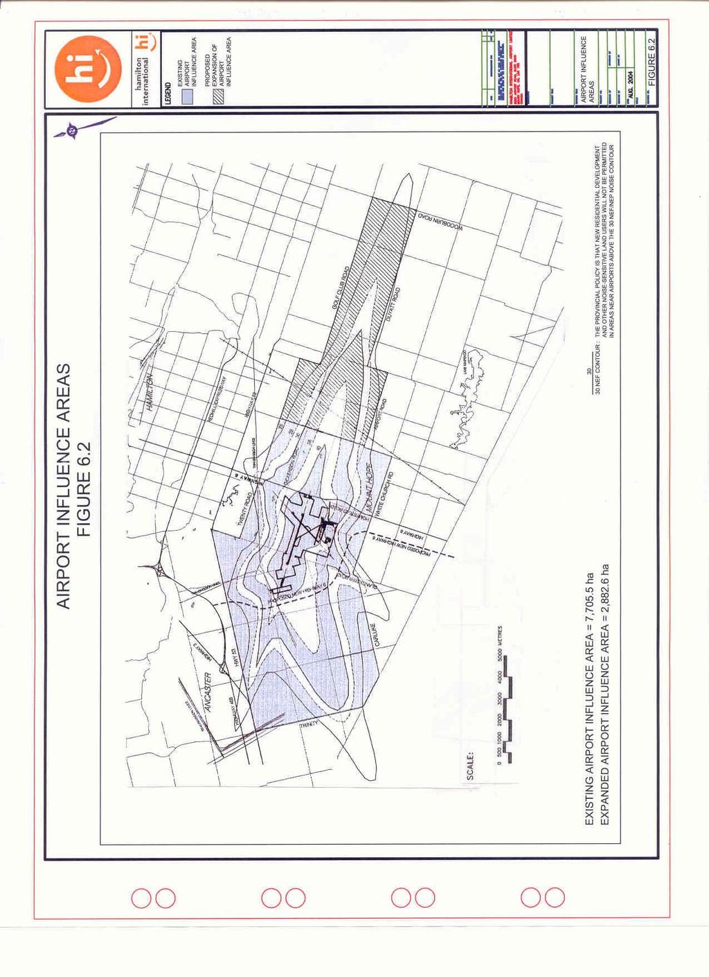
81
82 Transitional and approach zoning electronic Protection areas Air traffic control line of sight protection areas Lands held in reserve for future airside development At present, the airport has a capacity of approximately 140,000 to 426,000 aircraft movements depending on the mix of IFR and VFR traffic. With the introduction of parallel taxiways and high-speed exits, this capacity can be further increased and airside efficiency and safety considerably enhanced. Within the time frame of the Airport Master Plan, it is not anticipated that demand will ever approach the current airfield runway capacity.the construction of an additional runway is not being considered as a component of the 2004 Airport Master Plan Update. The Master Plan, however, does recognize the need to expand the existing runways, and reserves appropriate lands to ensure this. With respect to airside development, the objectives of the Airport Master Plan are: Enhance the operational efficiency and safety of the existing runway and taxiway system. Provide flexibility for the future expansion the existing airside infrastructure to provide improved operating efficiencies for existing air carrier operators and to provide new opportunities for the use of larger aircraft and longer stage lengths. Provide airside access to new airside commercial development areas. Accommodate the expansion of Runway to 2,743 m (9,000 ft.). The expansion and reconstruction of Lima would only occur if demand from general aviation activities warranted this work or if Alpha were disrupted by ATB construction. Short-term projects ( ) include: A business case would have to be demonstrated for each of these capital expenditures prior to its commencement ATB expansion Phase 1 and renovation of the existing ATB; Completion of new terminal apron expansion to the east of the existing ATB; this can occur concurrently with the ATB expansion project ; Removal of all buildings east of the existing ATB that would impact ATB and apron expansion; Construction of specific components of the parallel taxiway system; Provision of CAT 2 ILS system on Runway 12-30; Extension of Taxiway "D" to provide access to future airside commercial lands; Extension of taxiway Whiskey to the east so as to allow development of future airside commercial lands. Medium term projects ( ) include: Construction of new taxiways to provide access to accommodate expansion of commercial development; Hamilton International Airport Page 70 of Master Plan
83 Construction of ATB Phase 2 development to the west; Provision of new high speed exits on Runway 12-30; Provision of parallel taxiway access to terminal area from Runway 12-30; Provision of ILS on Runway Long term projects ( ) include: Extension of Runway 06-24; Construction of taxiway parallel to Runway 06-24; Construction of taxiways to serve Dickenson Road commercial development; Construction of Piers to the north of the ATB core. Very long term projects (2020+) include: Construction of a taxiway parallel to and north of Runway to serve commercial development; Construction of a taxiway parallel to and west of Runway to serve new terminal development. All of the airside development projects identified above can be accommodated within the existing boundaries of the airport with the exception of the extension of Runway The extension of this runway to 2,743 m will require both the partial closure of Airport Road and the acquisition of additional land. The minimum land required to accommodate this expansion is 32.2 ha. The extension of Runway will necessitate the construction of a service road north of the New Highway 6 right-of-way in order to link the remaining portions of Airport Road Airport Terminal & Reserve With a capacity to accommodate approximately 540,000 annual passengers, the current terminal facility does not meet demands demonstrated in WestJet s hub activities demonstrated that the catchment area could support in excess of six hundred thousand passengers. As CanJet and other carriers rebuild the void left by WestJet in 2004 it is evident that in the foreseeable future there will be a need to expand existing facilities. The existing facilities can accommodate 10 to15 narrow body flights a day. In 2003 the airport was experiencing 27 flights per day. Passengers at HI are currently provided with convenient ground load access between the parking lot and the aircraft. The capability of processing passengers quickly is a distinct strength of the airport that should be enhanced. With the growth of passenger jet service in 2003, HIAL completed the detailed design of a seven gated terminal facility (Phase 1) that would allow passengers to access the aircraft directly from a second story holdroom. A phase 2 preliminary design also exists, however a detailed design was deferred. Hamilton International Airport Page 71 of Master Plan
84 Table 6.3 ATB Expansion Phase 1 & Phase 2 Phase 1 Phase 2 Time Span (Years) 2005 to to 2014 Floor Area (m2) 20,600 9,400 Footprint area (m2) 12,500 6,100 Gates 7 12 Passenger Capacity 2,100,000 3,600,000 The Airport Master Plan identifies a reserve area associated with the existing terminal building and groundside areas that can accommodate a substantial expansion to the existing facilities. Sufficient lands are currently available to accommodate an expansion through Phase 1. The intent is to allow general aviation activities to remain in Hangars 1, 2 and 3 through out Phase 1 and 2 so long as their presence does not impact the operation of the expanding ATB. See Figure 6.4 on the following page for a diagrammatic illustration of the Terminal Expansion Phases 1 and Airport Support & Reserve Airport Support services are those required to support the operations of the airport. These include airport maintenance, crash/fire, security, air traffic control and fuel farms. The services are provided by both the airport administration and by outside agencies such as Nav Canada. For airport support services, the objectives of the master plan are: Reserve sufficient lands for airport support functions and provide appropriate facilities. Locate and provide airport support services in an efficient and cost effective manner. Ensure that the provision of airport support facilities does not impede future commercial development. The Airport Master Plan Update recognizes that sufficient lands should be provided adjacent to the existing airport support facilities to provide the flexibility necessary to accommodate future expansion. Although alternate sites were considered, continued operations at the existing site are preferred due to its central airside location and the high cost of relocation. Hamilton International Airport Page 72 of Master Plan

85
86 Airport Maintenance In the short term, a 600-m2 expansion of the equipment maintenance garage is required in order to accommodate the storage of newly acquired heavy airport maintenance equipment. With the medium to long term expansion of airside pavements, further additional equipment and storage expansion will be necessary. Fire Hall With respect to airside access and response time, the existing fire hall is appropriately located. If and when passenger traffic increases to a sustained level that requires an increase in the category of service, consideration should be given at this time to the provision of an additional apparatus bay and expansion of training areas. Fuel Farm The existing fuel farm has the capacity to serve the short term needs of the airport. In providing additional areas for longer term expansion requirements, consideration should be given to the reservation of lands directly south of Airport Road adjacent to the existing facility. This could allow for a future underground feed directly from the jetfuel pipeline at Nanticoke, which passes 4 to 5 km east of the airport and which currently services Pearson Airport. Existing easements along new Hwy 6 may be utilized. Control Tower Facility Nav Canada has indicated the existing control tower facility has the capability to serve the existing and anticipated needs of the airport. No expansion of the facility is seen within the time frame of the Master Plan. The short and long term development of the airport takes into account the tower's line of sight requirements to both the existing and proposed aircraft maneuvering surfaces Airside Commercial & Reserve Airside Commercial activities at Hamilton International encompass a wide range of activities that require direct access to the airside operational areas. These activities include: Aircraft ground servicing, Storage and maintenance, Air cargo / courier activities, Cross Dock Facility, Aircraft rental, and Charter services. For airside commercial development, the objectives of the Master Plan are to: Reserve adequate land for future expansion of airside related commercial activities with a focus on air cargo and courier operations, hangar and aircraft maintenance facilities; Hamilton International Airport Page 73 of Master Plan
87 Accommodate short-term demand for land within existing airport boundaries without compromising long-term flexibility; Provide for landside access to airside commercial development areas from existing arterial roads and the New Highway 6 Airport Expressway; Provide sufficient lands adjacent to airport-related commercial development to accommodate opportunities for inter-modal distribution and value added processing; and Provide opportunities for a Free Trade Zone with direct airside access. Under this Airport Master Plan Update, the definition of Airside Commercial activities includes those activities that require or benefit by direct access to the airside. These activities include: Aircraft maintenance/storage hangars Fixed base operators Air cargo facilities Air courier facilities Flight kitchens Aircraft sales and rentals Flight training schools Flying clubs Air charter businesses Airline support facilities The priority of airside commercial development will be in the areas of hangar and aircraft maintenance facilities as well as air cargo / courier activities and other activities associated with the air cargo/courier industry. It is not anticipated that there will be significant growth in light general aviation activity. At present, there is a shortfall demand for approximately 13,000 m2 of air cargo facility space. Taking into account requirements for airside apron space and landside parking and truck maneuvering areas, this in turn translates into an immediate requirement for approximately 12 hectares of land area. In 1999 it was envisioned that by the year 2003 an additional 40,000 m2 for air cargo and hangar / aircraft maintenance facility space would be required. Development of the lands east of WestJet s Hangar site is currently being undertaken for apron and hangar facilities. The total land area available for development in this area amounts to approximately 7.2 ha of land. This area is referred to as Parcel B or more specifically as Part 3, Part 3 Extension and Part 5 of Dwg. No 22133RPL2. Within 15 years, the demand for additional air cargo facility space could be as high as 125,000 m2, with a resultant land requirement of 36 hectares of land. In the short term, the expansion of Airside Commercial development can only occur in one area located within the existing Airport boundary. This area includes the Lands associated with and under option to Purolator (5.3 ha.) This land does not have the Hamilton International Airport Page 74 of Master Plan
88 capacity to alleviate the existing short fall in demand. In order to meet forecasted land requirements, additional lands beyond the present airport boundary will be required. The Airport Master Plan recognizes a number of potential opportunities for the expansion of airside commercial development. These opportunities include lands located east of the present airport boundaries and lands located between Runway and Dickenson Road. These lands on the east side of the airport must be serviced by the appropriate utilities and roads before becoming available for development. In the long term, air cargo / courier facilities will have to be accommodated on lands located adjacent to Dickenson Road. Earlier development of these lands may also be desirable from an operational perspective. The location of air cargo activities in this area would minimize taxiing distances for larger aircraft using Runway 12-30, and would reduce congestion associated with aircraft movements in the terminal area. If in the future, Dickenson Road is connected directly to a New Highway 6 expressway, the commercial lands located north of Runway will have excellent landside access, furthering its desirability for courier / air cargo operations. Much of the lands south of Dickenson Road and north of the airport boundary is designated as a "Special Policy Area" in anticipation that, in the future, these lands will be required for airport-related uses. At present, the land is used for agricultural and rural residential uses. Within this Special Policy Area, there exists a 25 ha. parcel of land that is designated specifically for airside commercial uses including air cargo and/or aircraft maintenance. A problem associated with development in this area is the lack of municipal services and utilities. Prior to any large-scale development, substantial investment will have to be made on the provision of such services. Commercial development in this area would also require the construction of a taxiway to access the site. It is anticipated that lands located south of Dickenson Road, and to the west of Glancaster Road will not be required for airport-related purposes until well beyond the horizon of this Airport Master Plan. These lands should remain as Agricultural, but with the recognition from the City of Hamilton that they are to be designated for future airport-related commercial uses. The land along the northern limit of Hangar Road associated with Hangar #1, 2 and 3 can, for the medium term, remain as airside commercial and can be redeveloped as required for this purpose. However, in the long term these lands may eventually fall under the classification of Airport Terminal Reserve. It is a recommendation of this Master Plan that the land associated with Hangar #4 be rezoned as Airport Terminal to allow for ATB Phase 2 construction. Hangar # Lease Expiry Date 1 Dec 31, March 31, March 3, Non-Airside Commercial & Reserve To support the vision of Hamilton International becoming a major cargo hub and intermodal facility, it is essential that lands be identified adjacent to the airport that can Hamilton International Airport Page 75 of Master Plan
89 accommodate a full range of associated activities such as freight warehousing, distribution, and value added processing. In addition, there are a number of commercial, retailing, and hospitality activities that also benefit from their proximity to an airport. With respect to non-airside commercial development, the objectives of the Airport Master Plan Update are to: Reserve adequate land for future aviation and non-aviation commercial land uses that do not require direct airside access. Provide sufficient land to implement innovative cargo development, related distribution and other value-added processing opportunities. Provide opportunities for inter-modal activity through direct adjacency between airside and non-airside commercial activities. Provide direct access to main transportation networks. Provide airport-related commercial development in a manner that is compatible with City of Hamilton s Official Plan. Under this Airport Master Plan Update, the definition of non-airside commercial development includes those activities that require or benefit from the presence of the airport, but do not require direct access to the airside. These activities include: Freight distribution facilities Sort facilities Light manufacturing/processing High technology industries Warehousing Commercial offices Hospitality services including restaurants, hotels, convention facilities Communication activities Car rental/servicing facilities Flight kitchens Gas stations Airline support facilities. In the short to medium term, the development of non-airside commercial development could occur on lands that run adjacent to and west of Highway 6 / Homestead Drive. These lands include the Aeropark Business Park (24 ha.) and are presently designated under the City s Official Plan for the uses described above. In the longer term, non-airside commercial development has been identified for lands south of Dickenson Road. It is intended, however, that these lands remain as a Special Policy Area until such time as the lands are required for commercial development purposes. With the development of New Highway 6 will arise an opportunity to develop lands south of Airport Road in the vicinity of the New Highway 6 / Airport Road intersection. Lands located south of Airport Road, and on either side of the New Highway 6 access Hamilton International Airport Page 76 of Master Plan
90 should be developed for non-airside commercial development. These lands should be designated as a Special Policy Area that would allow for airport-related commercial uses in the future. The development of these lands for commercial uses should not take place until such time as New Highway 6 has been constructed to the Air Terminal Access Road. In the very long term, airport-related commercial development should be allowed to occur on lands located west of the airport between New Highway 6 and the existing airport boundary. These lands, which are currently designated for agricultural use, should remain as such, with recognition, through appropriate policy statements, that in the future, they should be designated for future airport-related commercial uses General Commercial Reserve General commercial development describes commercial activities that are not airport related. These activities are directed towards the surrounding community. These activities include: Retail and service commercial Personal and business services Recreational and entertainment facilities Restaurants and Taverns Hotels and motels Cultural, community and institutional uses that do not conflict with commercial intent of designated lands Residential as a component of a permitted use. With respect to general commercial development, the objectives of this Airport Master Plan Update are to: Accommodate adequate land for future expansion of general commercial development within the Mount Hope Urban Area. Provide general commercial development in a manner that is compatible with the official plans of the City of Hamilton. Under the Airport Master Plan Update, general commercial development is provided along the north side of Airport Road from the Canadian Warplane Heritage Museum to Homestead Drive. A second area is provided along the west side of Homestead Drive from Airport Road to Highway 6. These areas are consistent with the general commercial areas identified by the City of Hamilton official plan. It is intended that commercial activities within these designated areas will provide services to the community, rather than the airport. These commercial areas will also provide a buffer between the airport and the community of Mount Hope. None of the lands identified for general commercial development are within the existing airport boundary. Hamilton International Airport Page 77 of Master Plan
91 6.4 Servicing Sanitary Sewers The existing airport sanitary sewer system will provide service for airport commercial development located in the area between Airport Road and the old hangar line. Sanitary services for potential airport commercial development south of Airport Road can be provided through the 450 mm diameter trunk sanitary sewer located on Airport Road. Sanitary services for proposed airport/ airside commercial development fronting on Airport Road and east of the Canadian Warplane Heritage Museum can be provided through the 450 mm diameter trunk sanitary sewer located on Airport Road, or the existing 300 mm diameter sanitary sewer on the East Cargo Road. Sanitary services for future airport commercial development adjacent to the Westjet facility have been extended along East Cargo Road utilizing a combination of gravity and force mains. This work was completed in Sanitary services for future airport commercial development fronting onto future extensions of the East Cargo Road, can be provided by construction of a new sanitary sewer extending from the existing limit of East Cargo Road to Highway 6. The proposed sewer would connect to the existing large diameter sanitary sewer on Highway 6. Land acquisitions to the east would be required and a servicing easement established. There is no sanitary sewer servicing available on Dickenson Road. Therefore, a proposed sewer and/or sewage pumping station that would connect to the sanitary sewer on Highway 6 would provide sanitary services for future airport commercial development fronting onto Dickenson Road West. Due to the capacity of the sanitary pumping station located approximately 1,200 meters North of Airport Road West, the City of Hamilton has placed a restriction of 53 liters per second for peak discharge from the Airport. Therefore, existing and future sanitary sewage demands and allocations should be reviewed and upgrading of the City s sewage collection system or other innovative solutions (i.e. wetland treatment systems) will be required to accommodate future long-term airport development. These requirements should be included in the City of Hamilton s Municipal Services Master Plan and GRIDS planning processes Water Services The existing and new airport water mains will provide services for future airport commercial development located between Airport Road and the old hangar line. Water services for future airport/ airside commercial development south of Airport Road can be provided through the existing 400 mm and new 600 mm diameter trunk water mains located on Airport Road. Hamilton International Airport Page 78 of Master Plan
92 Water services for future airport commercial development fronting on to Airport Road, east of the Canadian Warplane Heritage Museum can be provided through the 400 mm diameter trunk water main located on Airport Road, or the existing 250 mm diameter water main on the East Cargo Road. Water services for future airport commercial development adjacent to the WestJet facility have been provided in 2002 by extending the existing 250 mm diameter water main east on East Cargo Road. This service provides a dead end condition and could be improved if connected via a future service easement towards Homestead Drive. Water services for future airport commercial development fronting onto the Highway 6, can be provided by a proposed service that would connect to the existing 400 diameter water main on Highway 6. The existing 150 mm diameter water main on Dickenson Road will provide servicing for future airport commercial development fronting onto Dickenson Road West Stormwater Drainage A Master Drainage Plan for the entire airport lands has not been undertaken. Instead, individual drainage studies pertaining to specific developments have been undertaken and are listed in Table 6.5 below. Table 6.5 Airport Drainage Studies Internal Consultant Project Date Reference # 031 Avgroup East Cargo Rd Oct Development 032 Avgroup Glycol Management Sept Facility 043 Paragon Jet Port Hangar Sept Giffels Apron Expansion Oct Giffels Apron Expansion Sept A Master Stormwater Drainage Plan would provide a more global understanding of the drainage characteristics of the overall airport lands by: Identifying drainage catchment areas and characteristics. Establishing criteria for stormwater quality / quantity from the site / catchment. Identifying locations / volumes required for on site stormwater management facilities. Development of a wetlands scheme for ensuring water quality of runoff from airport lands. Hamilton International Airport Page 79 of Master Plan
93 The Stormwater Management Plan will assist the Airport and their future tenants in the preparation of detailed plans that will comply with the Airport Master Plan to ensure that runoff quality and quantity are similar to current levels in order to minimize effects on drainage streams and their biota. Such a study should be included in the HIAL capital-planning budget. The Airport will work with the City of Hamilton s Strategic and Environmental Planning Section as this group prepares a work program for an Airport Stormwater Management Plan, which will likely not commence until after the GRIDS process in concluded. This Section, as part of their 2004 work program, will undertake the investigation of stormwater drainage and management (servicing) opportunities and constraints for the area surrounding the Airport. This will include fulfillment of any Class EA requirements for stormwater management initiatives. 6.5 Land Acquisition Requirements At present, Hamilton International has limited lands to accommodate short-term commercial development and airside expansion. In order to accommodate short term expansion, it is recommended that the City of Hamilton acquire serviceable lands adjacent to the airport. In order to accommodate medium to long-term airside commercial expansion, further additional lands beyond the existing airport boundaries will be required. The City of Hamilton should acquire the lands required for airside development. Lands for nonairside development could either be acquired by the City or potentially be developed by a third party with a "through the fence" agreement to accommodate airport growth. Expansion of Runway will require the airport to acquire a 32 ha parcel of land south of Airport Road. It may also be desirable for the City of Hamilton to acquire lands adjacent to existing Highway 6 that are located under the approach to Runway 30 to improve runway utilization and to relieve residential properties located immediately adjacent to the airport that are heavily impacted by aircraft noise. These properties include residences located on the west side of Highway 6, under the approach to Runway 30. Other similarly affected residences may also be located adjacent to the airport on Glancaster and Southcote Roads, on Book Road directly under the approach path to Runway 12-30, and the residence located on the north side of Airport Road adjacent to the approach to Runway Implementation / Phasing The phasing of development proposed under this Airport Master Plan is illustrated in Figures 6.6 and 6.7. The development of airside and non-airside commercial land uses identified in the development concept will be dependent upon the demand for such lands. In the short term, development of airside commercial uses will be accommodated within the existing boundaries of the airport, most likely by the existing tenant base Hamilton International Airport Page 80 of Master Plan
94 that require additional facilities for growth, with the exception of lands along the New Highway 6 Airport access corridor that are located outside the airport boundary. In the medium to long term, there will be a need to expand airside development beyond the present boundaries. With respect to the phasing of commercial development, there are a number of alternatives, which can be accommodated in the development concept. Although medium-term development has been identified in the southeast quadrant of the airport, the potential also exists, for such development to take place on lands located between Dickenson Road and Runway The development of these lands in the medium term would, however, require the provision of additional services. Similarly, the completion of the New Highway 6 airport expressway could precipitate earlier development of lands located south of Airport Road and north of the highway. Implementation of airside improvements in the short term is in direct response to existing operational constraints. The implementation and phasing of airside projects in the medium to long term will depend on a number of factors including future growth in annual aircraft movements and the future mix of aircraft. Expansion of the airside infrastructure will only be undertaken when there is a demonstrated need for such improvements. Specific measures however, should be undertaken by both HIAL and the City of Hamilton to ensure that the full airport development proposed in the Airport Master Plan is protected. Hamilton International Airport Page 81 of Master Plan

95

96
97 7.0 Environmental Management 7.1 Environmental Mission Statement Hamilton International strives to meet or exceed all applicable regulations, codes, guidelines and municipal bylaws and is committed to operating and maintaining the airport in an environmentally responsible manner. The airport is committed to environmental protection and to providing a safe and healthy workplace for employees, tenants, customers and the general public. 7.2 Goals and Objectives Hamilton International currently has in place an Environmental Management Plan. The primary goal of the plan is to "ensure that Hamilton International operates in an environmentally responsible manner according to applicable laws and regulations, accepted management practices and with sensitivity to community and public concerns", The objectives of the Environmental Management Plan are: To establish and maintain Hamilton International as an environmentally responsible facility. To ensure compliance of all environmental legislation and guidelines at Hamilton International. To inform all airport tenants and employees of their environmental responsibilities in order to achieve the above objectives. To familiarize the reader with the airport's environmental policies. To ensure that all parties understand the concept of sustainable growth. 7.3 Environmental Management Practices and Procedures The Environmental Management Plan prepared by HIAL identifies the management and implementation strategies associated with a number of environmental issues at the airport. Each issue identified in the plan is provided with a strategy that outlines the due diligence required to ensure that environmental objectives are met. In addition to this, the airport has an Emergency Procedures Plan that identifies contingency procedures to be followed in the event of an environmental emergency. It should also be noted that any required Environmental Assessment studies will be finalized, as required, prior to implementation of municipal undertakings. Furthermore, alternative solutions to the infrastructure problems/opportunities will be further reviewed during the Class EA process. Hamilton International Airport Page 82 of Master Plan
98 8.0 Recommendations The 2004 Airport Master Plan Update has supplemented and updated the 1999 recommendations and herein confirms those recommendations, which have been accomplished or are in the process of being fulfilled. 8.1 Airport / Community Interface It is recommended that: Noise Considerations Hamilton International Airport Limited update NEF mapping on a regular 5-year basis; Hamilton International, through the Noise Management Plan, continues to investigate other options for addressing noise mitigation for the short and medium terms; That the City of Hamilton give consideration to the purchase of residential properties located immediately adjacent to the airport that are heavily impacted by aircraft noise. These properties include residences located on the west side of Highway 6, under the approach to Runway 30, residences located adjacent to the airport on Glancaster and Southcote Roads, residences located on Book Road, directly under the approach path to Runway 12-30, and the residence located on the north side of Airport Road adjacent to the approach to Runway 06 and terminal frontage area; The City of Hamilton adopt the following policies based on the 1996 NEF Contours: a. For lands currently identified as Residential under official plans that no residential or other noise sensitive land uses be permitted in areas identified as NEF 30 or greater; b. For lands currently designated as Agricultural that no new rural residential subdivisions or other noise sensitive uses be permitted in areas identified as NEF 25 or greater; c. That the existing Airport Influence Area be expanded to include those lands identified under the NEF 25 contour or greater, based on the 1996 NEF contours, and as illustrated in Figure 6.2. Hamilton International Airport Page 83 of Master Plan
99 d. The City of Hamilton adopt stricter sound insulation requirements for all new residential units constructed within the Airport Influence area. Requirements would address: Exterior insulation factors Exterior wall and roof assemblies Mechanical ventilation/air conditioning Exterior wall openings Window glazing That the City of Hamilton gives consideration to providing financial compensation to those residents located within the NEF 35 contour or greater, based on the 1996 NEF noise contours. Compensation would be used to assist homeowners in providing additional sound insulation measures; Hamilton International Airport Limited, in combination with the City of Hamilton explores operational options that would result in a more equitable distribution of noise during nighttime activity Registered Airport Zoning It is recommended that: The City of Hamilton, with the assistance of Hamilton International Airport Limited, proceed with amendments to the current Registered Zoning for the airport to accommodate the extension of Runway to 2,743 m The City of Hamilton identify land areas to be protected against the erection of obstacles that could jeopardize the licensing and operation of the airport in its final configuration and support this protection through the application of a Airport Vicinity Protection Area and associated municipal by-laws Airport Ground Access It is recommended that: The City of Hamilton give consideration to initiating the process of acquiring lands required to accommodate the eventual extension of Dickenson Road to Book Road, Hamilton International Airport Page 84 of Master Plan
100 and that the construction of this extension be undertaken upon completion of the construction of the New Highway 6 airport expressway; The City of Hamilton give consideration to a new service road to be located north of the New Highway 6 right of way between the Terminal Access Road and Butter Road. This road will be required if Runway is extended; The City of Hamilton give consideration to a new road that would be intended for the access of future airside and airport commercial developments located east of the current airport boundary and west of Existing Highway The City of Hamilton give consideration to the provision of a direct link to the new Red Hill Creek Expressway / Lincoln Alexander Parkway intersection to improve road access between the Airport and the QEW (from the east); The City of Hamilton give consideration to the provision of access to the Golden Horseshoe Light Rail Transit network. 8.2 Land Use It is recommended that: Airside Reserve Hamilton International Airport Limited should give consideration to the development of the following projects in the short term. Provision of CAT 2 ILS system on Runway 12-30; Provision of an ILS system on Runway 06-24; Provision of a second RVR site for Runway 12-30; Upgrade pavement structure for Runway 06-24, primarily at threshold positions (2/3 of runway length), so as to facilitate large, Code E aircraft weight classes; Extension of taxiway Whiskey to provide access to future airside commercial lands east of WestJet Hangar (agreed to be completed by a new tenant); Completion of new terminal apron expansion to the east of the proposed ATB expansion (Phase 1) in conjunction with the ATB expansion (Phase 1); Provision of an airside perimeter roadway; wild life control roads, and emergency access roads. Hamilton International Airport Page 85 of Master Plan
101 Hamilton International Airport Limited should give consideration to the development of the following projects in the medium term: Construction of taxiway parallel to Runway 12-30; Construction of a section of taxiway parallel to Runway from Taxiway "C" to new taxiway parallel to Runway 12-30; Installation of a DGPS system to augment the existing and new ILS facilities; Provision of new high speed exits on Runway 12-30; Provision of parallel taxiway access to terminal area from Runway 12-30; Construction of a section of taxiway, parallel to Runway 06-24, between Taxiways "Charlie" and "Alpha", Hamilton International Airport Limited should give consideration to the development of the following projects in the long term: Expansion of Runway to 3,048 m; Construction of remaining taxiway parallel to Runway 06-24; Construction of taxiways to serve Dickenson Road commercial development That the City of Hamilton give consideration to the acquisition of lands located south of Airport Road and north of the proposed New Highway 6 Airport access corridor, to accommodate potential expansion of airside and terminal reserve infrastructure Airport Support It is recommended that: Hamilton International Airport Limited reserve sufficient lands adjacent to existing airport support functions to accommodate future expansion Hamilton International Airport Limited undertake in the short term, an expansion of the existing airport maintenance facility that would include, 3 additional vehicle bays; additional administrative, workshop, amenity and storage spaces; additional paved parking and maneuvering areas. Hamilton International Airport Page 86 of Master Plan
102 Hamilton International Airport Limited should consider the provision of an additional apparatus bay and an expansion of the training and amenity areas for the existing fire hall if and when passenger traffic volumes dictate an increase in the service category Airside Commercial It is recommended that: Hamilton International Airport Limited accommodates short-term demand for airside commercial development on lands located within existing boundaries Hamilton International Airport Limited give consideration to the development concept as set out in Figure 6.1B with respect to the medium and long-term development of Airport Commercial land uses. In order to achieve this, basic services would be required at each site Non-Airside Commercial It is recommended that: Hamilton International Airport Limited give consideration to the development concept as set out in Figure 6.1B with respect to the development of Non-Airside Commercial land uses The City of Hamilton give consideration to the designation of lands south of Airport Road and north of the New Highway 6 right of way as a Special Policy Area that would allow Airside and Non-Airside Commercial and Commercial Reserve lands uses as described in Figure 6.1B The City of Hamilton give consideration to the development, in the very long term, of lands identified in Figure 6.1A for Airport Commercial uses and provide appropriate policy statements that describe their future use The City of Hamilton recognizes the Airport and surrounding employment lands (the Aerotropolis concept) as an emerging development node and ensures that lands are developed in accordance with the planning principals and objectives contained in this Airport Master Plan. Hamilton International Airport Page 87 of Master Plan
103 8.2.5 General Commercial It is recommended that: Hamilton International Airport Limited give consideration to the development concept as set out in Figure 6.1A with respect to the development of General Commercial land uses. 8.3 Services It is recommended that: The City of Hamilton give consideration to the Airport Master Plan and provide the appropriate water and sanitary services to accommodate demands that will be imposed by future development. This includes the provision of new and upgraded services; The Storm water Management Plan have due regard for the Airport Master Plan and that it be incorporated into the Master Plan upon its completion; The Storm water Management Plan for Hamilton International be subject to the review and approval by the City of Hamilton. Hamilton International Airport Page 88 of Master Plan
104 Appendix A TP 1247E Land Use in the Vicinity of Airports, 7th Edition
105
106
107
108
109
110
111
112
113
114
115
116
117
118
119
120
121
122
123
124 Appendix B Proposal for a Hamilton International Airport Vicinity Protection Area
125

126
127
128
129
130
131
132
133
134
135
136
137
138
139
140
141
142
143
144
145
146
147
148
149
150
151
152
153
154
155
156
157
158
159
160

161

162
Executive Summary. MASTER PLAN UPDATE Fort Collins-Loveland Municipal Airport
 Executive Summary MASTER PLAN UPDATE Fort Collins-Loveland Municipal Airport As a general aviation and commercial service airport, Fort Collins- Loveland Municipal Airport serves as an important niche
Westover Metropolitan Airport Master Plan Update
 Westover Metropolitan Airport Master Plan Update June 2008 INTRODUCTION Westover Metropolitan Airport (CEF) comprises the civilian portion of a joint-use facility located in Chicopee, Massachusetts. The
MONTEREY REGIONAL AIRPORT MASTER PLAN TOPICAL QUESTIONS FROM THE PLANNING ADVISORY COMMITTEE AND TOPICAL RESPONSES
 MONTEREY REGIONAL AIRPORT MASTER PLAN TOPICAL QUESTIONS FROM THE PLANNING ADVISORY COMMITTEE AND TOPICAL RESPONSES Recurring topics emerged in some of the comments and questions raised by members of the
DRAFT. Master Plan RESPONSIBLY GROWING to support our region. Summary
 Master Plan GROWING 2017-2037 RESPONSIBLY to support our region Summary DRAFT 2 1 Introduction Over the next three decades, Southern Ontario is set to experience significant growth its population will
Federal Budget Submission. Prepared for the House of Commons Standing Committee on Finance. Greater Toronto Airports Authority
 2018-2019 Federal Budget Submission Prepared for the House of Commons Standing Committee on Finance Greater Toronto Airports Authority - August 2017 - Contact: Lorrie McKee Director, Public Affairs and
CHAPTER 1 EXECUTIVE SUMMARY
 CHAPTER 1 EXECUTIVE SUMMARY 1 1 EXECUTIVE SUMMARY INTRODUCTION William R. Fairchild International Airport (CLM) is located approximately three miles west of the city of Port Angeles, Washington. The airport
1.0 Project Background Mission Statement and Goals Objectives of this Sustainable Master Plan
 TABLE OF CONTENTS CHAPTER 1 INTRODUCTION 10 Project Background 1-1 11 Mission Statement and Goals 1-1 12 Objectives of this Sustainable Master Plan 1-2 CHAPTER 2 INVENTORY 20 Airport Background 2-1 201
Toronto Pearson Master Plan Greater Toronto Airports Authority October 4, 2017
 Toronto Pearson Master Plan 2017-2037 Greater Toronto Airports Authority October 4, 2017 Stakeholder engagement The GTAA has been proactively engaging stakeholders to outline how it is preparing to meet
Draft Concept Alternatives Analysis for the Inaugural Airport Program September 2005
 Section 10 Preferred Inaugural Airport Concept 10.0 Introduction The Preferred Inaugural Airport Concept for SSA was developed by adding the preferred support/ancillary facilities selected in Section 9
Draft Concept Alternatives Analysis for the Inaugural Airport Program September 2005
 Draft Concept Alternatives Analysis for the Inaugural Airport Program September 2005 Section 3 - Refinement of the Ultimate Airfield Concept Using the Base Concept identified in Section 2, IDOT re-examined
Table of Contents. Master Plan March 2014 TOC i Spokane International Airport
 Table of Contents Page Chapter 1 Inventory 1. Introduction... 1 1 1.1 Community Profile... 1 2 1.1.1 Location and Setting... 1 1 1.1.2 Climate... 1 2 1.1.3 Socioeconomic Conditions... 1 5 1.1.4 Area Land
ERIE INTERNATIONAL AIRPORT MASTER PLAN TABLE OF CONTENTS
 EXECUTIVE SUMMARY ERIE INTERNATIONAL AIRPORT MASTER PLAN TABLE OF CONTENTS PAGE NO. CHAPTER 1-INTRODUCTION... 1-1 1.01 General...1-1 1.02 Purpose and Scope of Study...1-1 1.03 The Planning Process...1-2
 Existing Conditions AIRPORT PROFILE Passenger Terminal Complex 57 air carrier gates 11,500 structured parking stalls Airfield Operations Area 9,000 North Runway 9L-27R 6,905 Crosswind Runway 13-31 5,276
Aviation, Rail, & Trucking 6-1
 6-1 This chapter describes the services, facilities, and condition of air, rail, and trucking as components of the transportation system. These three intermodal areas have an impact on the factors to be
The implementation of this Master Plan will be undertaken in logical stages to meet passenger and workforce demands.
 The implementation of this Master Plan will be undertaken in logical stages to meet passenger and workforce demands. Connecting People Building Opportunities 198 Brisbane Airport Corporation CHAPTER 10
DRAFT GENERAL IMPLEMENTATION PLAN AND SPECIFIC IMPLEMENTATION PLAN MIDDLETON MUNICIPAL AIRPORT MOREY FIELD. Revised 12/12/03
 DRAFT GENERAL IMPLEMENTATION PLAN AND SPECIFIC IMPLEMENTATION PLAN MIDDLETON MUNICIPAL AIRPORT MOREY FIELD Revised 12/12/03 As recommended for approval by the Plan Commission General Project Description
Document prepared by MnDOT Office of Aeronautics and HNTB Corporation. MINNESOTA GO STATE AVIATION SYSTEM PLAN
 LAST UPDATE JULY 2013 Acknowledgements The preparation of this document was financed in part by a grant from the Federal Aviation Administration (Project No: 3-27-0000-07-10), with the financial support
JOSLIN FIELD, MAGIC VALLEY REGIONAL AIRPORT DECEMBER 2012
 1. Introduction The Federal Aviation Administration (FAA) recommends that airport master plans be updated every 5 years or as necessary to keep them current. The Master Plan for Joslin Field, Magic Valley
Birmingham Airport 2033
 Over the next 15 years, we will expand and improve the Airport to maximise our potential as a single runway airport by investing 500 million in new development. Our plans take account of our forecasted
Addendum - Airport Development Alternatives (Chapter 6)
") Bowers Field Addendum - Airport Development Alternatives (Chapter 6) This addendum to the Airport Development Alternatives chapter includes the preferred airside development alternative and the preliminary
Bowers Field Addendum - Airport Development Alternatives (Chapter 6) This addendum to the Airport Development Alternatives chapter includes the preferred airside development alternative and the preliminary
FORECASTING FUTURE ACTIVITY
 EXECUTIVE SUMMARY The Eagle County Regional Airport (EGE) is known as a gateway into the heart of the Colorado Rocky Mountains, providing access to some of the nation s top ski resort towns (Vail, Beaver
DEVELOPMENT OF TOE MIDFIELD TERMINAL IROJECT CAPACITY ENHANCEMENT REPORT DEPARTMENT OF AVIATION TOM FOERSTER CHAIRMAN BARBARA HAFER COMMISSIONER
 PETE FLAHERTY COMMISSIONER TOM FOERSTER CHAIRMAN DEPARTMENT OF AVIATION BARBARA HAFER COMMISSIONER STEPHEN A. GEORGE DIRECTOR ROOM M 134, TERMINAL BUILDING GREATER PITTSBURGH INTERNATIONAL AIRPORT PITTSBURGH,
REGION OF WATERLOO INTERNATIONAL AIRPORT AIRPORT MASTER PLAN EXECUTIVE SUMMARY MARCH 2017
 REGION OF WATERLOO INTERNATIONAL AIRPORT AIRPORT MASTER PLAN EXECUTIVE SUMMARY MARCH 2017 Contact: Chris Wood, Airport General Manager cwood@regionofwaterloo.ca (519) 648-2256 ext. 8502 Airport Master
Lake Tahoe Airport Master Plan Public Meeting March 16, 2015
 Lake Tahoe Airport Master Plan Public Meeting March 16, 2015 What is an Airport Master Plan? a comprehensive study of an airport [that] usually describes the short, medium, and long term development plans
Airport Planning Area
 PLANNING AREA POLICIES l AIRPORT Airport Planning Area LOCATION AND CONTEXT The Airport Planning Area ( Airport area ) is a key part of Boise s economy and transportation network; it features a multi-purpose
TABLE OF CONTENTS. General Study Objectives Public Involvement Issues to Be Resolved
 TABLE OF CONTENTS Description Page Number LIST OF ACRONYMS... a CHAPTER ONE INTRODUCTION General... 1-1 Study Objectives... 1-1 Public Involvement... 1-2 Issues to Be Resolved... 1-2 CHAPTER TWO EXISTING
STUDY OVERVIEW MASTER PLAN GOALS AND OBJECTIVES
 INTRODUCTION An Airport Master Plan provides an evalua on of the airport s avia on demand and an overview of the systema c airport development that will best meet those demands. The Master Plan establishes
Sunshine Coast Airport Master Plan September 2007
 Sunshine Coast Airport Master Plan September 2007 Contents CONTENTS... I ACKNOWLEDGEMENT... II DISCLAIMER... III 1 EXECUTIVE SUMMARY...IV 1 INTRODUCTION... 1 2 AVIATION DEMAND FORECAST... 5 3 AIRCRAFT
SouthwestFloridaInternational Airport
 SouthwestFloridaInternational Airport SouthwestFloridaInternationalAirportislocatedinLee CountyalongtheGulfCoastofSouthFlorida,tenmiles southeastofthefortmyerscentralbusinessdistrict. Theprimaryhighwayaccesstotheairportfrom
Chapter 2 FINDINGS & CONCLUSIONS
 Chapter 2 FINDINGS & CONCLUSIONS 2.01 GENERAL Dutchess County acquired the airport facility in 1947 by deed from the War Assets Administration. Following the acquisition, several individuals who pursued
CHAPTER 1: INTRODUCTION
 CHAPTER 1: INTRODUCTION Purpose and Scope The information presented in this report represents the study findings for the 2016 Ronan Airport Master Plan prepared for the City of Ronan and Lake County, the
CRITICAL FACTORS FOR THE DEVELOPMENT OF AIRPORT CITIES. Mauro Peneda, Prof. Rosário Macário AIRDEV Seminar IST, 20 October 2011
 CRITICAL FACTORS FOR THE DEVELOPMENT OF AIRPORT CITIES Mauro Peneda, Prof. Rosário Macário AIRDEV Seminar IST, 20 October 2011 Introduction Airports are becoming new dynamic centres of economic activity.
CHAPTER 4: ALTERNATIVES
 MSP Long Term Comprehensive Plan Update Metropolitan Airports Commission 4.1 INTRODUCTION CHAPTER 4: ALTERNATIVES Several alternatives were developed and evaluated based on their capability to meet the
Introduction DRAFT March 9, 2017
 Chapter Overview The City of Redmond (City) initiated an update to the Airport Master Plan ( Plan ) to assess the facility and service needs of the Redmond Municipal Airport ( the Airport ) throughout
Table of Contents. Overview Objectives Key Issues Process...1-3
 Table of Contents Chapter One Introduction Overview...1-1 Objectives...1-1 Key Issues...1-2 Process...1-3 Chapter Two Inventory of Existing Conditions Airport Setting...2-1 Locale...2-1 Airport Surroundings...2-5
2006 ANNUAL GENERAL MEETING
 2006 ANNUAL GENERAL MEETING Address by Garth F. Atkinson President and Chief Executive Officer April 19, 2006 Thank you Peter and good morning ladies and gentlemen and invited guests. Before proceeding
Punta Gorda Airport Master Plan Update
 Punta Gorda Airport Master Plan Update Draft Executive Summary Prepared for: The Charlotte County Airport Authority January 2018 Charlotte County Airport Authority James Herston, Chair Robert D. Hancik,
Draft Concept Alternatives Analysis for the Inaugural Airport Program September 2005
 Draft Concept Alternatives Analysis for the Inaugural Airport Program September 2005 Section 1 - Introduction This report describes the development and analysis of concept alternatives that would accommodate
BNA Master Plan Update Community Advisory Committee Meeting No. 5
 A Six Sigma Organization BNA Master Plan Update Community Advisory Committee Meeting No. 5 September 19, 2012 Introductions MNAA Staff RW Armstrong Team Albersman & Armstrong, Ltd. Atkins North America,
TABLE OF CONTENTS. Washington Aviation System Plan Update July 2017 i
 TABLE OF CONTENTS Chapter 1 Overview... 1-1 1.1 Background... 1-1 1.2 Overview of 2015 WASP... 1-1 1.2.1 Aviation System Performance... 1-2 1.3 Prior WSDOT Aviation Planning Studies... 1-3 1.3.1 2009 Long-Term
Official Plan Amendment No 76 Airport and Employment Hearing 2011 P a g e 1
 Official Plan Amendment No 76 Airport and Employment Hearing 2011 P a g e 1 8(f) 2.2.3 Managing Growth Within the Urban Area Employment 19. In all urban communities outside the Central Area, opportunities
Chapter 8.0 Implementation Plan
 Chapter 8.0 Implementation Plan 8.1 Introduction This chapter is the culmination of the analytical work accomplished in the previous chapters. The result is a prioritized list of the essential projects.
AIRPORT MASTER PLAN UPDATE
 AIRPORT MASTER PLAN UPDATE PENSACOLA INTERNATIONAL AIRPORT Technical Advisory Committee Meeting #2 June 20, 2017 Agenda» Introduction» Facility Requirements Airside Terminal Landside General Aviation Cargo
BNA Master Plan Update Public Meeting No. 2
 A Six Sigma Organization BNA Master Plan Update Public Meeting No. 2 September 18, 2012 Agenda BNA Master Plan Update Consultants Status of the BNA Master Plan Update Workstation Boards Forecasts of Aviation
Airport Master Plan. Brookings Regional Airport. Runway Runway 17-35
 Runway 17-35 Airport Master Plan Runway 12-30 Brookings Regional Airport Table of Contents Table of Contents Chapter 1: Master Plan Goals... 1-1 1.1. Introduction... 1 1.2. Objective 1 Identify improvements
 Executive Summary This document contains the Master Plan for T. F. Green Airport. The goal of a master plan is to provide a framework of potential future airport development in a financially feasible manner,
Chapter 4.0 Alternatives Analysis
 Chapter 4.0 Alternatives Analysis Chapter 1 accumulated the baseline of existing airport data, Chapter 2 presented the outlook for the future in terms of operational activity, Chapter 3 defined the facilities
STAFF REPORT. Airport Land Use Plan Consistency Review: Santa Barbara Airport Master Plan. MEETING DATE: November 19, 2015 AGENDA ITEM: 7D
 STAFF REPORT SUBJECT: Airport Land Use Plan Consistency Review: Santa Barbara Airport Master Plan MEETING DATE: AGENDA ITEM: 7D STAFF CONTACT: Peter Imhof, Andrew Orfila RECOMMENDATION: Adopt findings
2009 Muskoka Airport Economic Impact Study
 2009 Muskoka Airport Economic Impact Study November 4, 2009 Prepared by The District of Muskoka Planning and Economic Development Department BACKGROUND The Muskoka Airport is situated at the north end
Stimulating Airports is Stimulating the Economy
 Stimulating Airports is Stimulating the Economy House of Commons Standing Committee on Finance Pre-budget 2010 Submission August 14 th, 2009 Executive Summary Atlantic Canada Airports Association s (ACAA)is
Bloor Street West Rezoning Application for a Temporary Use By-law Final Report
 STAFF REPORT ACTION REQUIRED 3741 3751 Bloor Street West Rezoning Application for a Temporary Use By-law Final Report Date: June 12, 2007 To: From: Wards: Reference Number: Etobicoke York Community Council
TERMINAL DEVELOPMENT PLAN
 5.0 TERMINAL DEVELOPMENT PLAN 5.0 TERMINAL DEVELOPMENT PLAN Key points The development plan in the Master Plan includes the expansion of terminal infrastructure, creating integrated terminals for international,
Airport Master Plan Update
 Duttchessss Countty Airrporrtt Masstterr Plan Updatte Airport Master Plan Update Final Report Dutchess County Airport Town of Wappingers, New York C&S Engineers, Inc. 499 Col. Eileen Collins Blvd. Syracuse,
Billy Bishop Toronto City Airport; Porter Airlines Proposal Review; Interim Results/Findings, Airbiz, 26 June 2013
 Billy Bishop Toronto City Airport - Outstanding Questions for Transport Canada EXECUTIVE SUMMARY Transport Action has reviewed the reports published by Airbiz and LPS Avia Consulting and found that they
Aviation Development
 Aviation Development Gold Coast Airport has efficient and cost effective passenger processing and aircraft turn-around times that is underpinned by a strong focus on safety. 6.1 INTRODUCTION This focus
PULLMAN-MOSCOW REGIONAL AIRPORT Runway Realignment Project
 PULLMAN-MOSCOW REGIONAL AIRPORT Runway Realignment Project GENERAL AIRPORT INFORMATION AIRPORT USERS Airport ownership: Public, owned by the Pullman-Moscow Regional Airport Board Year opened: February
DRAFT FINAL REPORT AIRPORT MASTER PLAN. Rifle Garfield County Airport Revised May 15, 2014
 DRAFT FINAL REPORT AIRPORT MASTER PLAN Rifle Garfield County Airport Revised May 15, 2014 As required by Paragraph 425.B(4) of FAA Order 5100.38C, Airport Improvement Program (AIP) Handbook: The preparation
Merritt Island Airport
 TABLE OF CONTENTS CHAPTER 1 INTRODUCTION... 1-1 INTRODUCTION AND PROJECT OVERVIEW... 1-1 General Guidelines... 1-1 Prior Planning Documentation... 1-2 Key Issues... 1-2 Goals and Objectives... 1-2 Regulatory
Mayor Dave Bronconnier cc: All City of Calgary Alderman. Eastbound Extension of Airport Trail and Related Works
 May 7, 2009 Mayor Dave Bronconnier cc: All City of Calgary Alderman The City of Calgary Mr. John Hubbell, GM Transportation 700 Macleod Trail SE Calgary AB T2P 2M5 Re: Eastbound Extension of Airport Trail
NOISE ABATEMENT PROCEDURES
 1. Introduction NOISE ABATEMENT PROCEDURES Many airports today impose restrictions on aircraft movements. These include: Curfew time Maximum permitted noise levels Noise surcharges Engine run up restrictions
Appendix D Project Newsletters. Tacoma Narrows Airport. Master Plan Update
 Appendix D Project Newsletters Tacoma Narrows Airport Master Plan Update This appendix contains the newsletters distributed throughout the project. These newsletters provided updates and information on
Current and Forecast Demand
 Existing Facilities Jacksonville International Airport (JIA) is served by a number of airside and landside facilities. There are two runways that serve the airport in an open V configuration. The Annual
Airport Master Plan. Rapid City Regional Airport. October 2015 FAA Submittal
 Airport Master Plan Rapid City Regional Airport October 2015 FAA Submittal Rapid City Regional Airport Master Plan Update Table of Contents Executive Summary... i Scope & Timeline... i Forecasts... i Preferred
STUDY WORK GROUP MEETING No. 3. November 29, 2016
 STUDY WORK GROUP MEETING No. 3 November 29, 2016 Agenda Welcome and introductions Update project schedule Brief overview of previous SWG meeting Update on aviation forecasts Introduction to airfield demand/capacity
DEPARTMENT: CIVIL ENGINEERING SEMESTER: III SUBJECT CODE / Name: CE2303/ Railway, Airport and Harbors Engineering 2 MARK QUESTIONS AND ANSWERS
 DEPARTMENT: CIVIL ENGINEERING SEMESTER: III SUBJECT CODE / Name: CE2303/ Railway, Airport and Harbors Engineering 2 MARK QUESTIONS AND ANSWERS 1.Define wind Coverage (AUC NOV/DEC 2010),(AUC NOV/DEC 2011)
Appendix B Ultimate Airport Capacity and Delay Simulation Modeling Analysis
 Appendix B ULTIMATE AIRPORT CAPACITY & DELAY SIMULATION MODELING ANALYSIS B TABLE OF CONTENTS EXHIBITS TABLES B.1 Introduction... 1 B.2 Simulation Modeling Assumption and Methodology... 4 B.2.1 Runway
FORT LAUDERDALE-HOLLYWOOD INTERNATIONAL AIRPORT ENVIRONMENTAL IMPACT STATEMENT DRAFT
 D.3 RUNWAY LENGTH ANALYSIS Appendix D Purpose and Need THIS PAGE INTENTIONALLY LEFT BLANK Appendix D Purpose and Need APPENDIX D.3 AIRFIELD GEOMETRIC REQUIREMENTS This information provided in this appendix
The purpose of this Demand/Capacity. The airfield configuration for SPG. Methods for determining airport AIRPORT DEMAND CAPACITY. Runway Configuration
 Chapter 4 Page 65 AIRPORT DEMAND CAPACITY The purpose of this Demand/Capacity Analysis is to examine the capability of the Albert Whitted Airport (SPG) to meet the needs of its users. In doing so, this
During Construction. Full Resident and Non-Resident Services. Contract Administration and Construction Supervision of Groundside and Airside Projects
 Page 1 of 5 May 21, 2007 HOME PROFILE SECTORS & SERVICES CAREERS SEMINARS & PAPERS LINK airport development Description of Service transportatio services link Airport Developm Pre-Construction Area Development
Burke Lakefront Airport (BKL) Master Plan Update
 Master Plan Update") Burke Lakefront Airport () Master Plan Update Public Workshop August 2, 2007 City of Cleveland Department of Port Control (DPC) City of Cleveland DPC Studies Currently In Progress Market Assessment & Feasibility
Burke Lakefront Airport () Master Plan Update Public Workshop August 2, 2007 City of Cleveland Department of Port Control (DPC) City of Cleveland DPC Studies Currently In Progress Market Assessment & Feasibility
AIRFIELD ACCESSIBILITY AND SAFETY INITIATIVE FAQs
 Q1: What is the Airfield Accessibility and Safety Initiative? AIRFIELD ACCESSIBILITY AND SAFETY INITIATIVE FAQs A1: The Airfield Accessibility and Safety Initiative is a three-year infrastructure project
St. Paul Downtown Airport (STP)
") Reliever Airports: NOISE ABATEMENT PLAN St. Paul Downtown Airport (STP) 1 INTRODUCTION The noise abatement plan for the St. Paul Downtown Airport (STP) was prepared in recognition of the need to make the
Reliever Airports: NOISE ABATEMENT PLAN St. Paul Downtown Airport (STP) 1 INTRODUCTION The noise abatement plan for the St. Paul Downtown Airport (STP) was prepared in recognition of the need to make the
A Master Plan is one of the most important documents that can be prepared by an Airport.
 The Master Plan A Master Plan is one of the most important documents that can be prepared by an Airport. A Master Plan is a visionary and a strategic document detailing planning initiatives for the Airport
Chapter 1 Introduction
 Chapter 1 Introduction Introduction and Purpose The Airport Master Planning process evaluates an airport s physical facilities, establishes a forecast for future demand, and identifies a development plan
2018 Airport Master Plan Overview of Development Concepts. Greg Ballentine (WSP)
") 2018 Airport Master Plan Overview of Development Concepts Greg Ballentine (WSP) Thank You Stakeholder and community consultation has included discussions with over 40 stakeholder groups including airport
2018 Airport Master Plan Overview of Development Concepts Greg Ballentine (WSP) Thank You Stakeholder and community consultation has included discussions with over 40 stakeholder groups including airport
Airport Master Planning Process & Update
 Airport Master Planning Process & Update David Stewart ICAO Airport Master Planning Task Force Subgroup Leader ICAO Airport Planning Seminar for the SAM Region Lima, Peru 10-14 Sep. 2018 1 Speaker: David
Whangarei Airport. Prepared by Carine Andries 10/20173
 Whangarei Airport Prepared by Carine Andries 10/20173 March 2010 TABLE OF CONTENTS 1 2 3 INTRODUCTION... 3 AIRPORT ROLE AND FUNCTION... 3 AIRPORT FEATURES AND CAPACITY... 3 3.1 3.2 3.3 3.4 3.5 3.5.1 3.5.2
Appendix C AIRPORT LAYOUT PLANS
 Appendix C AIRPORT LAYOUT PLANS Appendix C AIRPORT LAYOUT PLANS Airport Master Plan Santa Barbara Airport As part of this Airport Master Plan, the Federal Aviation Administration (FAA) requires the development
N4 Carrick-on-Shannon to Dromod Road Project. 2.1 Introduction
 Chapter 2 Need for the Scheme 2.1 Introduction The National Primary Route N4, Dublin to Sligo is a strategic corridor from Dublin to the northwest and border counties (See RCSR 101 in Volume 2). The National
Wyoming Valley Airport Proposed Improvements. Presented June 26, 2012 By The WBW Airport Advisory Board & FBO
 Wyoming Valley Airport Proposed Improvements Presented June 26, 2012 By The WBW Airport Advisory Board & FBO Contents Purpose of meeting Airport overview Background of proposed improvements SWOT analysis
Element 640 State of Rhode Island Airport System Plan - Overview
 Element 640 State of Rhode Island Airport System Plan - Overview This document represents the Rhode Island Airport Corporation s (RIAC) plan for the state airport system (ASP). The plan establishes state
Finance and Implementation
 5 Finance and Implementation IMPLEMENTATION The previous chapters have presented discussions and plans for development of the airfield, terminal, and building areas at Sonoma County Airport. This chapter
Parkland County Municipal Development Plan Amendment Acheson Industrial Area Structure Plan
 Parkland County Municipal Development Plan Amendment Acheson Industrial Area Structure Plan New Plan Acheson Industrial Area Structure Plan Amendment Parkland County Municipal Development Plan Board Reference
CASE STUDY The New Guayaquil International Airport
 www.jacobs.com worldwide CASE STUDY The New Guayaquil International Airport Prepared for ICAO Airport Planning Seminar for the SAM Region Lima, Peru 10-14 Sep. 2018 September 11, 2018 Outline Existing
Chapter 1 Introduction and Project Overview
 Chapter 1 Introduction and Project Overview Kittitas County in cooperation with the Federal Aviation Administration (FAA) is updating the Airport Master Plan for Bowers Field Airport (FAA airport identifier
CHAPTER 9 RUNWAYS AND AIRFIELD DEVELOPMENTS
 CHAPTER 9 RUNWAYS AND AIRFIELD DEVELOPMENTS CANBERRA AIRPORT IS THE ONLY 24 HOUR BOEING 747, B777-300 AND A340 CAPABLE AIRPORT...BETWEEN BRISBANE AND MELBOURNE. 9 Runway and airfield developments Airports
CHAPTER FOUR AIRPORT ALTERNATIVES
 4.0 INTRODUCTION CHAPTER FOUR The goal of the master planning process is to provide the City of New Smyrna Beach with an assessment of the adequacy and capabilities of the Airport as well as to identify
BELFAST MUNICIPAL AIRPORT OVERVIEW
 BELFAST MUNICIPAL AIRPORT OVERVIEW LOCATION AND HISTORY Belfast Municipal Airport (Federal Aviation Administration (FAA) airport code BST, International Civil Aviation Organization airport code KBST, FAA
Airport Master Plan Update June 15, 2017
 Airport Master Plan Update June 15, 2017 www.harveyfield.com The Master Plan is a 20-year plan to understand the needs of current and future users of the Airport. This is important to ensure that safe
Lake Tahoe Airport Master Plan
 Lake Tahoe Airport Master Plan City Council Briefing October 20, 2015 What is an Airport Master Plan? a comprehensive study of an airport [that] usually describes the short, medium, and long term development
ATM STRATEGIC PLAN VOLUME I. Optimising Safety, Capacity, Efficiency and Environment AIRPORTS AUTHORITY OF INDIA DIRECTORATE OF AIR TRAFFIC MANAGEMENT
 AIRPORTS AUTHORITY OF INDIA ATM STRATEGIC PLAN VOLUME I Optimising Safety, Capacity, Efficiency and Environment DIRECTORATE OF AIR TRAFFIC MANAGEMENT Version 1 Dated April 08 Volume I Optimising Safety,
RSAT RUNUP ANALYSIS 1. INTRODUCTION 2. METHODOLOGY
 RSAT RUNUP ANALYSIS 1. INTRODUCTION The FAA Runway Safety Action Team (RSAT) is a team of FAA staff that works with airports to address existing and potential runway safety problems and issues. The RSAT
FUTENMA REPLACEMENT FACILITY BILATERAL EXPERTS STUDY GROUP REPORT. August 31, 2010
 FUTENMA REPLACEMENT FACILITY BILATERAL EXPERTS STUDY GROUP REPORT August 31, 2010 MANDATE AND SCOPE OF WORK: In order to achieve the earliest possible relocation of Marine Corps Air Station Futenma, the
Region of Waterloo Planning, Development and Legislative Services Region of Waterloo International Airport Office of Economic Development
 Region of Waterloo Planning, Development and Legislative Services Region of Waterloo International Airport Office of Economic Development To: Chair Tom Galloway and Members of the Planning and Works Committee
Appendix F International Terminal Building Main Terminal Departures Level and Boarding Areas A and G Alternatives Analysis
 Appendix F International Terminal Building Main Terminal Departures Level and Boarding Areas A and G Alternatives Analysis ITB MAIN TERMINAL DEPARTURES LEVEL & BOARDING AREAS A & G ALTERNATIVES ANALYSIS
Safety, Infrastructure, and Tenant Improvement Project. Public Hearing Informational Brochure February 26, 2013
 New York State Department of Transportation Safety, Infrastructure, and Tenant Improvement Project Public Hearing Informational Brochure February 26, 2013 This DEIS/Draft EA evaluates the potential impacts
CHAPTER 3 ALTERNATIVES CONSIDERED
 CHAPTER 3 ALTERNATIVES CONSIDERED 3.0 ALTERNATIVES The 2010 Stevensville Airport Master Plan contained five (5) airside development options designed to meet projected demands. Each of the options from
SUBMISSION BY THE BOARD OF AIRLINE REPRESENTATIVES OF NEW ZEALAND ON THE DRAFT QUEENSTOWN LAKES DISTRICT COUNCIL DRAFT PLAN
 SUBMISSION BY THE BOARD OF AIRLINE REPRESENTATIVES OF NEW ZEALAND ON THE DRAFT QUEENSTOWN LAKES DISTRICT COUNCIL DRAFT PLAN Background to BARNZ BARNZ is an incorporated society comprising 19 member airlines
Regular Board Meeting August 4, 2015
 Regular Board Meeting August 4, 2015 1616 Airport Circle Hailey, ID 83333 208.788.4956 PUBLIC COMMENT FY 16 Rates & Charges FY 16 Budget Approval Rates & Charges will provide the Board the ability to operate
The presentation was approximately 25 minutes The presentation is part of Working Group Meeting 3
 This is the presentation for the third Master Plan Update Working Group Meeting being conducted for the Ted Stevens Anchorage International Airport Master Plan Update. It was given on Thursday March 7