BELFAST MUNICIPAL AIRPORT OVERVIEW
|
|
|
- Thomasina Gilbert
- 5 years ago
- Views:
Transcription
1 BELFAST MUNICIPAL AIRPORT OVERVIEW LOCATION AND HISTORY Belfast Municipal Airport (Federal Aviation Administration (FAA) airport code BST, International Civil Aviation Organization airport code KBST, FAA site number 07837), owned and operated by the City of Belfast, is a 220- acre, public use, non-towered, general aviation airport located off of U.S. Route 1 and between both phases of the Belfast Airport Business Park; its airport reference point is 44 24'33.8" north, 69 00'42.6" west, and has a defined elevation of feet above mean sea level. The airport was constructed in the early 1940 s as part of the U.S. government s home defense program, though it was never ultimately used by the military. Its initial construction was funded by the Works Progress Administration, the Civil Aeronautics Administration, the City of Belfast, and the State of Maine. The airport s main and only active runway (Runway 15-33) has existed in its current configuration (150 /330 ) and length (4,000 ) since the 1960 s. ROLE AND OPERATIONS As a general aviation airport, scheduled commercial airline service does not exist at Belfast Municipal Airport. The airport caters to small aircraft and corporate jets, and it supports the economy of Belfast and the surrounding region (for example, the staff and/or clients of two of Belfast s largest companies, athenahealth and Front Street Shipyard, make regular use of this airport). As the airport also serves as an important gateway to the Belfast region, it is expected that people who initially experience Belfast through the airport may decide in the future to construct a private hangar at the airport, purchase housing in Belfast, and/or bring their business or job to Belfast. Belfast Municipal Airport was classified in the 2015 National Plan of Integrated Airport Systems (NPIAS) as a General Aviation airport, defined as an airport that does not receive scheduled commercial service and accounts for enough activity (having usually at least 10 based aircraft) and is located at least 20 miles from the nearest NPIAS airport. Belfast Municipal Airport was classified in the FAA s study entitled General Aviation Airports: A National Asset as a local airport, defined as an airport that supplements local communities by providing access primarily to intrastate and some interstate markets. Belfast Municipal Airport is also currently classified in the Maine Aviation Systems Plan Update as a Level III airport, defined as an airport that serves a primary role in local economies, focused on supporting a variety of general aviation activities such as business, emergency service, recreational, and personal flying; these airports should be capable of accommodating all single-engine and some small twin-engine general aviation aircraft. The FAA s most recent (January 2014) Terminal Area Forecast for the airport estimates the number of annual aircraft operations at 10,000 (or operations per month). Since the fall of 2014, the airport has had installed a system (the General Aviation Recording Device (GARD) system) that records all radio transmissions made at or near the airport on its Common Traffic Advisory Frequency, and uses the number of transmissions to estimate the number of airport operations. According to the GARD system, operations during the year period of 8/1/2015-7/31/2016 averaged per month (the GARD system currently considers 9 transmissions equivalent to 2 operations). There are currently 24 ground leases in effect at the airport; each of these leased areas has built upon it a privatelyowned aircraft hangar, which range in size from 28 x 40 to 62 x 60, and Belfast Municipal Airport currently has 13 based aircraft.
2 FACILITIES AND INFRASTRUCTURE Runway Runway is Belfast Municipal Airport s only active runway. It measures 4,000 feet long by 100 feet wide, with a true bearing of / The surface is bituminous concrete with a weight bearing capacity of 30,000 pounds for single-wheel aircraft. The runway 15 approach end elevation, also the airport s official elevation, is feet above mean sea level, whereas the runway 33 approach end elevation is feet above mean sea level, meaning the runway has a gradient of approximately 1%, sloping down from the runway 15 end to the runway 33 end. The runway is equipped with pilot-controlled Medium Intensity Runway Lights (MIRLs) and Runway End Identifier Lights (REILs) at both ends. Both runway 15 and runway 33 have non-precision instrument approach runway markings, including centerline, runway designator (numerals), threshold markings, and aiming points. Both runway 15 and runway 33 are served by a non-precision area navigation (RNAV) global positioning system (GPS) approach, including localizer performance with vertical guidance (LPV). The runway was most recently reconstructed in 2004, and it also underwent crack sealing in According to the 2014 Maine Airport Pavement Conditions Report, the pavement has a pavement condition index value of 95, indicating that at that time it was in excellent condition. The runway s painted markings are currently in good condition and provide adequate contrast against the pavement surface. Runway Previously serving as the airport s crosswind runway, runway was decommissioned in 1982 due to the poor condition of the pavement, the high cost of repair and maintenance, and the infrequent use of the runway. A significant portion of this runway has been repurposed for the airport s existing hangar and apron development. Taxiways A-C Belfast Municipal Airport possesses a partial parallel taxiway for runway (taxiway A) that is supported and connected by two stub taxiways (taxiways B and C). Taxiway A, located roughly mid-field on the north side of runway 15-33, measures approximately 350 feet long by 35 feet wide, with a current runway centerline-to-taxiway centerline separation of 200 feet. Taxiways B and C both measure approximately 130 feet long by 35 feet wide. All of these taxiways possess a bituminous concrete surface. The taxiways were apparently last reconstructed prior to 1983 and, according to the 2014 Maine Airport Pavement Conditions Report, the pavement has a rating of 3, indicating that it is in generally good condition. Navigational Aids and Automated Weather Observing System Belfast Municipal Airport possesses navigational aids, including a lighted windsock, a segmented circle, a rotating beacon, and nighttime obstruction lights. The airport also has an automated weather observing system (AWOS); more specifically, an AWOS-3, which reports altimeter setting, wind data, visibility, ceiling, temperature, dew point, relative humidity, and condensation altitude data, and which can be accessed via radio, internet, and phone. Facilities and Other Infrastructure Belfast Municipal Airport possesses a number of facilities and other infrastructure; they are presented here roughly in order of location (the letters identify these on the plans and photos that accompany this overview): A) T-Hangar: constructed in 1950, this hangar is located adjacent to the Low Hangar (closer to the runway 15 end). It is a steel hangar with a concrete floor and a manually-operated sliding wooden door. It has a height of 12 feet, an opening/maximum width of 40.5 feet, and a depth of 26 feet, with a total area of 682 square feet. No utilities serve this hangar. This hangar is currently leased by DG Aviation, LLC, a fixed base operator.
3 B and C) Low Hangar: named after the owner of a former fixed base operator at this airport, this hangar was constructed in 1970, and is located off of Airport Road and taxiway B, consisting of two bays, each one being 16 feet high, 44 feet wide, and 37 feet deep (3,293 total square feet), each of which has their own motorized bi-fold door. The building is a pole building with treated structural verticals, with a steel exterior, has a concrete floor, and is minimally insulated. There is also a lobby/entrance structure of 116 square feet (which comes through C), bringing the total area for the entire structure to 3,409 square feet. The building is serviced by forced hot air (oil) heat (2 250-gallon tanks), 100-amp electricity, and municipal water, but no municipal sewer is available and there is no bathroom in this building. The hangar bay located closest to the runway 15 end (B) also has a waste oil heater (a 250-gallon tank). This hangar is also currently leased by DG Aviation, LLC, a fixed base operator. D) Shed: this structure is located between the end of Airport Road and taxiway B, and has a width of 20 feet and a depth of 20 feet, for a total area of 400 square feet. No utilities serve this structure. This building is currently being used for storage by the City of Belfast s Parks and Recreation Department. E) New Apron: a new bituminous concrete apron (46,926 square feet in area) was constructed in 2011 to accommodate larger aircraft. This apron has located upon it 7 tie-downs (4 smaller ones on the side closest to the runway, 3 larger ones on the side farthest from the runway); each of these tie-downs has access to its own engine block heater outlet. F) Old Apron: the older bituminous concrete apron (approximately 32,300 square feet in area) extends from the Terminal Building towards the runway. This apron contains 6 tie-downs (a set of 2 directly in front of the Terminal Building, and another set of 4 located closer to the runway). (These tie-downs do not have engine block heater outlets.) G) Terminal Building: constructed in 1950 (moved at a later date to its current location), this building is located between Wright Brothers Drive and the Old Apron, is 8 feet in height, and totals 1,092 square feet in size (over two floors; a ground floor and a finished basement). The building has electricity, is heated with propane ( gallon tanks), and contains a bathroom (septic field), and has a wood siding exterior. This building is currently used as a pilot planning area/lounge, and also hosts the City s radio, weather, and surveillance equipment. H) Concrete Fuel Pad: this structure is a concrete pad located between the Terminal Building, the Old Apron, and Wright Brothers Drive, is approximately 42 feet wide by 29 feet deep (approximately 1,218 square feet in area). This pad was previously used for the storage of the previous fixed base operator s 5,000-gallon 100 low-lead aviation fuel tank and aviation fuel truck, which were permanently removed from the airport in There is likely the ability to add/improve electrical service in this area, as there exists extra/unused conduit.
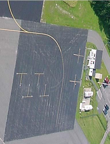
4 A B AIRPORT FACILITIES AND OTHER INFRASTRUCTURE (INDICATED BY LETTERS A-H IN RED) C D X X X E G H F

5 AIRPORT FACILITIES AND OTHER INFRASTRUCTURE (INDICATED BY LETTERS A-H IN RED) G H F A B C E D TAXIWAY A TAXIWAY B TOWARDS RUNWAY 15 END TAXIWAY C RUNWAY TOWARDS RUNWAY 33 END


6


7


8


9


10


11


12


13


14


15


16


17
Source: Chippewa Valley Regional Airport ASOS, Period of Record
 Chapter 1 Inventory Runway wind coverage is the percentage of time a runway can be used without exceeding allowable crosswind velocities. Allowable crosswind velocities vary depending on aircraft size
Current Airport Roles
 Chapter Four: Current Airport Roles Introduction Current airport roles are defined differently from national, state, and local perspectives. The Federal Aviation Administration (FAA) has established two
CHAPTER 1 INTRODUCTION AND BACKGROUND
 CHAPTER 1 INTRODUCTION AND BACKGROUND An Environmental Assessment (EA) evaluates the effects of a proposed Federal action on the surrounding environment and is prepared in compliance with the National
50 Ways to Improve Your Airport: Engaging Airport Management on Key Issues
 50 Ways to Improve Your Airport: Engaging Airport Management on Key Issues Tuesday, November 17, 2015 1:00 p.m. 2:00 p.m. PRESENTED BY: Charles D. Lamb, P.E. Airfield Lighting Image Source: Delta Airport
1.1.3 Taxiways. Figure 1-15: Taxiway Data. DRAFT Inventory TYPICAL PAVEMENT CROSS-SECTION LIGHTING TYPE LENGTH (FEET) WIDTH (FEET) LIGHTING CONDITION
 WIDTH (FEET) LIGHTING CONDITION") 1.1.3 Taxiways EWN has an extensive network of taxiways and taxilanes connecting the terminal, air cargo, and general aviation areas with the runways as listed in Figure 1-15. A 50-foot wide parallel taxiway
1.1.3 Taxiways EWN has an extensive network of taxiways and taxilanes connecting the terminal, air cargo, and general aviation areas with the runways as listed in Figure 1-15. A 50-foot wide parallel taxiway
Aviation Planning in Maine and Our Region. Stacie Haskell Aviation Coordinator & Study Manager Maine Department of Transportation April 27, 2011
 Aviation Planning in Maine and Our Region Stacie Haskell Aviation Coordinator & Study Manager Maine Department of Transportation April 27, 2011 Overview The National Aviation System Maine s Economic Dependence
ArcadiaMunicipalAirportislocatedonthesoutheast sideofarcadia,southofstateroute70,westofstate Route31,andisaccessiblefrom AirportRoad.
 Arcadia GeneralAviationAirport ArcadiaMunicipalAirportislocatedonthesoutheast sideofarcadia,southofstateroute70,westofstate Route31,andisaccessiblefrom AirportRoad.Arcadia islocatedapproximately30milesnortheastoftheport
Document prepared by MnDOT Office of Aeronautics and HNTB Corporation. MINNESOTA GO STATE AVIATION SYSTEM PLAN
 LAST UPDATE JULY 2013 Acknowledgements The preparation of this document was financed in part by a grant from the Federal Aviation Administration (Project No: 3-27-0000-07-10), with the financial support
Milton. PeterPrinceAirportislocatedinSantaRosaCounty, approximatelythreemileseastofmilton.
 Milton GeneralAviationAirport PeterPrinceAirportislocatedinSantaRosaCounty, approximatelythreemileseastofmilton. Existing Facilities Peter Prince Airport is served by one runway, Runway 18/36, 3,700 feet
Agenda: SASP SAC Meeting 3
 Agenda: SASP SAC Meeting 3 Date: 04/12/18 Public Involvement Plan Update Defining the System Recommended Classifications Discussion Break Review current system Outreach what we heard Proposed changes Classification
CHAPTER 1 BACKGROUND AND PROPOSED ACTION
 CHAPTER 1 BACKGROUND AND PROPOSED ACTION 1.0 INTRODUCTION An Environmental Assessment (EA) evaluates the effects of a proposed Federal action on the surrounding environment and is prepared in compliance
chapter 5 Recommended Master Plan Concept airport master plan MASTER PLAN CONCEPT
 chapter 5 Recommended Master Plan Concept airport master plan The planning process for Coolidge Municipal Airport has included several analytical efforts in the previous chapters intended to project potential
The Future of Aviation for Central New Mexico
 The Future of Aviation for Central New Mexico MISSION STATEMENT THE WHOLE AIRPORT EXPERIENCE HISTORY SPECIFICATIONS FACILITIES SERVICES RECENT IMPROVEMENTS FUTURE DEVELOPMENT & USE USER PROFILE The mission
DATE OF AERIAL PHOTOGRAPHY:
 DESCRIPTION RUNWAY SAFETY AREA RUNWAY PROTECTION ZONE TAXIWAY OBJECT FREE AREA DATE OF AERIAL PHOTOGRAPHY: 6-17-01 RUNWAY SAFETY AREA FOR PORTION OF RUNWAY 16L-34R SOUTH OF RUNWAY BRIDGE HAS A FAA WAIVER
CHAPTER 3 ALTERNATIVES CONSIDERED
 CHAPTER 3 ALTERNATIVES CONSIDERED 3.0 ALTERNATIVES The 2010 Stevensville Airport Master Plan contained five (5) airside development options designed to meet projected demands. Each of the options from
Tallahassee International Airport Master Plan. Technical Advisory Committee Meeting #2 October 19, 2016
 Tallahassee International Airport Master Plan Technical Advisory Committee Meeting #2 October 19, 2016 Agenda Welcome / Introductions Master Plan Process and Project Status Forecast of Aviation Demand
Request for Scoping Comments Regarding Environmental Issues of Concern
 March 16, 2009 Request for Scoping Comments Regarding Environmental Issues of Concern Environmental Assessment for Proposed Airport Land Lease and Airport Construction Pahrump Valley General Aviation Airport,
Inventory of Existing Conditions.
 A Inventory of Existing Conditions. Fort Collins-Loveland Municipal Airport, jointly owned and operated by the Cities of Fort Collins and Loveland, is located in the heart of a region with a thriving economy,
Safety, Infrastructure, and Tenant Improvement Project. Public Hearing Informational Brochure February 26, 2013
 New York State Department of Transportation Safety, Infrastructure, and Tenant Improvement Project Public Hearing Informational Brochure February 26, 2013 This DEIS/Draft EA evaluates the potential impacts
AIRSIDE CAPACITY AND FACILITY REQUIREMENTS
 AIRSIDE CAPACITY AND FACILITY REQUIREMENTS This Section investigates the capacity of the airport, its ability to meet current demand, and the facilities required to meet forecasted needs as established
Executive Summary. MASTER PLAN UPDATE Fort Collins-Loveland Municipal Airport
 Executive Summary MASTER PLAN UPDATE Fort Collins-Loveland Municipal Airport As a general aviation and commercial service airport, Fort Collins- Loveland Municipal Airport serves as an important niche
FACILITY REQUIREMENTS SUMMARY OF KEY ISSUES OVERVIEW
 FACILITY REQUIREMENTS SUMMARY OF KEY ISSUES OVERVIEW This summary is intended to provide a brief overview of the key issues associated with conformance to FAA standards at Methow Valley State Airport.
Navigation - Runways. Chap 2, Nolan
 Navigation - Runways Chap 2, Nolan 1 Runways Runways numbered to correspond to magnetic bearing Runway 27 has magnetic bearing 270 degrees Active Runway selected for headwind greater than 5 knots When
Chapter 8.0 Implementation Plan
 Chapter 8.0 Implementation Plan 8.1 Introduction This chapter is the culmination of the analytical work accomplished in the previous chapters. The result is a prioritized list of the essential projects.
OVERVIEW BASIC DESIGN FACTORS. Demand Determinants
 3 Airfield Airfield Design Design OVERVIEW The basic configuration of the runway and taxiway system at Hanford Municipal Airport has changed moderately since the airport was constructed in 1950. These
CATCODE ] CATCODE
![CATCODE ] CATCODE](/thumbs/82/85644630.jpg "CATCODE ] CATCODE") Runways. FAC: 1111 CATCODE: 111111 OPR: AFCEC/COS OCR: AF/A3O-A 1.1. Description. The runway is the paved surface provided for normal aircraft landings and take offs. Runways are classified as either Class
Runways. FAC: 1111 CATCODE: 111111 OPR: AFCEC/COS OCR: AF/A3O-A 1.1. Description. The runway is the paved surface provided for normal aircraft landings and take offs. Runways are classified as either Class
Chapter The All-new, World-class Denver International Airport Identify Describe Know Describe Describe
 Chapter 10 The aerospace subject is very large and diverse. As seen in previous chapters, there are many subject areas. So far you have learned about history, weather, space and aerodynamics. Now you will
Chapter 2: Existing Facilities
 Chapter 2: Existing Facilities This chapter describes the existing conditions at the airport and provides an inventory of existing facilities and infrastructure. It provides the baseline for future requirements,
Chapter Baseline Conditions
 Chapter 1.0 - Baseline Conditions This Chapter of the Master Plan provides an overview, or inventory, of the Newport State Airport (UUU). It is a compilation of all pertinent data relative to the airport,
STUDY WORK GROUP MEETING No. 3. November 29, 2016
 STUDY WORK GROUP MEETING No. 3 November 29, 2016 Agenda Welcome and introductions Update project schedule Brief overview of previous SWG meeting Update on aviation forecasts Introduction to airfield demand/capacity
Chapter Seven COST ESTIMATES AND FUNDING A. GENERAL
 Chapter Seven COST ESTIMATES AND FUNDING A. GENERAL This chapter delineates the recommended 2005 2024 Sussex County Airport Capital Improvement Program (CIP). It further identifies probable construction
Existing Facilities. Current and Forecast Demand
 Existing Facilities Albert Whitted Airport is owned and operated by the City of St. Petersburg ( City ). The airport property encompasses approximately 119 acres. The airport is served by two intersecting
Current and Forecast Demand
 Existing Facilities Jacksonville International Airport (JIA) is served by a number of airside and landside facilities. There are two runways that serve the airport in an open V configuration. The Annual
Table of Contents. Overview Objectives Key Issues Process...1-3
 Table of Contents Chapter One Introduction Overview...1-1 Objectives...1-1 Key Issues...1-2 Process...1-3 Chapter Two Inventory of Existing Conditions Airport Setting...2-1 Locale...2-1 Airport Surroundings...2-5
Chapter 5 Airport Development Alternatives
 Chapter 5 Airport Development Alternatives Introduction CHAPTER 5 AIRPORT DEVELOPMENT ALTERNATIVES JUNE 2013-1 Evaluation Process No-Action Alternative CHAPTER 5 AIRPORT DEVELOPMENT ALTERNATIVES JUNE 2013-2
Request for Proposals. Aviation Service Providers At Tri-Cities Airport
 Request for Proposals Aviation Service Providers At Tri-Cities Airport Proposals Due February 27, 2009 2:00 PM Village of Endicott 1009 E Main St. Endicott, New York 13760 Page 1 of 6 Introduction The
AIRPORT MASTER PLAN UPDATE
 AIRPORT MASTER PLAN UPDATE PENSACOLA INTERNATIONAL AIRPORT Technical Advisory Committee Meeting #2 June 20, 2017 Agenda» Introduction» Facility Requirements Airside Terminal Landside General Aviation Cargo
CHAPTER 5 - FACILITY REQUIREMENTS
 CHAPTER 5 - FACILITY REQUIREMENTS This chapter identifies the requirements for airfield and landside facilities to accommodate the forecast demand level. Facility requirements have been developed for the
Airport Master Plan. Brookings Regional Airport. Runway Runway 17-35
 Runway 17-35 Airport Master Plan Runway 12-30 Brookings Regional Airport Table of Contents Table of Contents Chapter 1: Master Plan Goals... 1-1 1.1. Introduction... 1 1.2. Objective 1 Identify improvements
Grants Pass Airport Master Plan & Airport Layout Plan Update
 Attendees: Grants Pass Airport Master Plan & Airport Layout Plan Update Meeting #3 January 26, 2010 Merlin Community Center 100 Acorn Street, Merlin 5:45 7:15 p.m. Josephine County Department of Airports:
Yolo County Airport. ALP Narrative Report. April Prepared by Mead & Hunt, Inc. for the County of Yolo, California
 Yolo County Airport ALP Narrative Report April 2016 Prepared by Mead & Hunt, Inc. for the County of Yolo, California Yolo County Airport ALP Narrative Report Prepared for the County of Yolo Mindi Nunes,
Hartford-Brainard Airport Potential Runway Closure White Paper
 Hartford-Brainard Airport Potential Runway 11-29 Closure White Paper June 2012 In recent years there has been discussion regarding the necessity of Runway 11-29 to the Hartford- Brainard Airport (HFD)
Airport Master Plan for. Brown Field Municipal Airport PAC Meeting #3
 Airport Master Plan for Brown Field Municipal Airport PAC Meeting #3 Public Meeting #1 > 8/24/17 from 5:30 to 8:00 pm > 41 attendees signed-in > Comments: > EAA area > Environmental constraints > Focus
105 SKY KING TAXI-WAY - SPICEWOOD, TEXAS
 S P I C E W O O D A I R P O R T 8 8 R H A N G A R F O R L E A S E 105 SKY KING TAXI-WAY - SPICEWOOD, TEXAS Available for immediate lease 7,200 SF (90 x 80 ) Class A Aircraft Hangar W / Climate Controlled
MetroAir Virtual Airlines
 MetroAir Virtual Airlines NAVIGATION BASICS V 1.0 NOT FOR REAL WORLD AVIATION GETTING STARTED 2 P a g e Having a good understanding of navigation is critical when you fly online the VATSIM network. ATC
Airport Master Plan for Montgomery-Gibbs Executive Airport PAC Meeting #3
 Airport Master Plan for Montgomery-Gibbs Executive Airport PAC Meeting #3 Agenda > Introductions > Public Meetings Overview > Working Paper 3 - Facility Requirements > Working Paper 4 - Environmental Baseline
Why are the underground fuel tanks being removed and replaced with above ground tanks?
 AIRPORT/CITIZEN FAQ This list of Frequently Asked Questions (FAQs) with responses are provided to share information related to airport topics with the Citizens of Georgetown. The questions / responses
Chapter 9 - AIRPORT SYSTEM DESIGN
 Chapter 9 - AIRPORT SYSTEM DESIGN 9.01 GENERAL This chapter discusses the development program for Dutchess County Airport to the year 2020. This airport system design is based upon the airport's existing
15 Precision Approach Path Indicator 33 None RSA 150 feet wide by 300 feet long 150 feet wide by 300 feet long
 The first (AMP) was completed in 1984 and updated in 2000. The current FAA approved Airport Layout Plan (ALP) is dated November 9, 2001. The FAA suggests updating the AMP every five year in accordance
B GEORGIA INFRASTRUCTURE REPORT CARD AVIATION RECOMMENDATIONS DEFINITION OF THE ISSUE. Plan and Fund for the Future:
 2014 GEORGIA INFRASTRUCTURE REPORT CARD B + RECOMMENDATIONS Plan and Fund for the Future: While the system continues to enjoy excess capacity and increased accessibility it still needs continued focus
PUBLIC NOTICE. Table 1 Projects Proposed by Amendment
 PUBLIC NOTICE The Dallas Department of Aviation (the Department) intends to file an amendment application to increase the PFC amount of one previously approved project at Dallas Love Field Airport (the
MASTER PLAN CONCEPT 1 DRAFT
 The Airport Master Plan Update for Dallas Executive Airport has included the development of aviation demand forecasts, an assessment of future facility needs, and the evaluation of airport development
AIRPORTS There are two types of airport environments: controlled and uncontrolled. A controlled airport has an operating control tower, staffed by
 AIRPORTS There are two types of airport environments: controlled and uncontrolled. A controlled airport has an operating control tower, staffed by either Federal or privately-contracted air traffic controllers.
Chapter Three AIRPORT FACILITY REQUIREMENTS/ALTERNATIVES
 Chapter Three AIRPORT FACILITY REQUIREMENTS/ALTERNATIVES Airport Layout Plan Report In this chapter, existing components of the Airport are evaluated so that the capacities of the overall system are identified.
Chippewa-Eau Claire Metropolitan Planning Area Long Range Transportation Plan
 1.2.7 2010 Eau Claire County Comprehensive Plan According to Eau Claire County s most recent comprehensive plan, the County will limit land use development adjacent to EAU in order to preserve the ability
Aviation, Rail, & Trucking 6-1
 6-1 This chapter describes the services, facilities, and condition of air, rail, and trucking as components of the transportation system. These three intermodal areas have an impact on the factors to be
City of Redding Airports
 City of Redding Airports Benton Airpark Redding Municipal Airport DEVELOPMENT AND USE GUIDELINES FOR GENERAL AVIATION HANGARS April 7, 2009 PREFACE The City of Redding, as owner of federally obligated
AERONAUTICAL SURVEYS & INSTRUMENT FLIGHT PROCEDURES
 AERONAUTICAL SURVEYS & INSTRUMENT FLIGHT PROCEDURES Current as of November 2012 ALASKA AVIATION SYSTEM PLAN UPDATE Prepared for: State of Alaska Department of Transportation & Public Facilities Division
Beginning balance available for Priority I Projects: $1,737,029
 2016 COAR Grant Cycle Priority I Projects Airport Name Project Name Requested Grant Amount Match % of Grant Match Total Project Cost or Total FAA Grant Match Amount required RUNNING TOTAL (Available Balance)
DRAFT MASTER PLAN UPDATE
 DRAFT MASTER PLAN UPDATE CHAPTER VI: AIRPORT LAYOUT PLAN NARRATIVE DRAFT REPORT APRIL 2017 PREPARED BY: Table of Contents WESTCHESTER COUNTY AIRPORT 6 AIRPORT LAYOUT PLAN NARRATIVE REPORT... 6-1 6.1 AGIS
Chapter 1 Introduction
 Chapter 1 Introduction Introduction and Purpose The Airport Master Planning process evaluates an airport s physical facilities, establishes a forecast for future demand, and identifies a development plan
Summary of Committee Discussion/Questions Metropolitan Transportation Services Senior Planner Russ Owen presented this item.
 Committee Report Business Item No. 2017-191 Transportation Committee For the Metropolitan Council meeting of September 13, 2017 Subject: Final Crystal Airport 2035 Long Term Comprehensive Plan (LTCP) Proposed
Runway and Taxiway Marking
 Lecture-38 10CV63 TE-II Runway and Taxiway Marking In order to aid pilots in guiding the aircraft on runways and taxiways, pavements are marked with lines and numbers. These markings are of benefit primarily
Airport Master Plan. Hutchinson Municipal Airport Butler Field (HCD) Hutchinson, Minnesota. July 2015
 Hutchinson, Minnesota. July 2015") Airport Master Plan Hutchinson Municipal Airport Butler Field HCD) Hutchinson, Minnesota July 2015 Submitted by: Bolton & Menk, Inc. 12224 Nicollet Avenue Burnsville, MN 55337 P: 952-890-0509 Airport Sponsor:
Airport Master Plan Hutchinson Municipal Airport Butler Field HCD) Hutchinson, Minnesota July 2015 Submitted by: Bolton & Menk, Inc. 12224 Nicollet Avenue Burnsville, MN 55337 P: 952-890-0509 Airport Sponsor:
CHAPTER 3 AIRPORT FACILITY REQUIREMENTS
 CHAPTER 3 AIRPORT FACILITY REQUIREMENTS 3.1 Introduction The existing runway and taxiway system at Skyhaven Airport provides more than adequate operational capacity to accommodate future peak hour and
DRAFT FINAL REPORT AIRPORT MASTER PLAN. Rifle Garfield County Airport Revised May 15, 2014
 DRAFT FINAL REPORT AIRPORT MASTER PLAN Rifle Garfield County Airport Revised May 15, 2014 As required by Paragraph 425.B(4) of FAA Order 5100.38C, Airport Improvement Program (AIP) Handbook: The preparation
CHAPTER FOUR AIRPORT ALTERNATIVES
 4.0 INTRODUCTION CHAPTER FOUR The goal of the master planning process is to provide the City of New Smyrna Beach with an assessment of the adequacy and capabilities of the Airport as well as to identify
3 INTRODUCTION. Chapter Three Facility Requirements. Facility Requirements PEAKING CHARACTERISTICS
 Chapter Three Facility Requirements 3 INTRODUCTION This chapter identifies the long-range airfield and terminal area facilities needed to satisfy the 20-year forecast of aviation demand at Monett Municipal
1 DRAFT. General Aviation Terminal Services Aircraft Hangars Aircraft Parking Aprons Airport Support Facilities
 To properly plan for improvements at Dallas Executive Airport, it is necessary to translate forecast aviation demand into the specific types and quantities of facilities that can adequately serve the demand.
DEPARTMENT: CIVIL ENGINEERING SEMESTER: III SUBJECT CODE / Name: CE2303/ Railway, Airport and Harbors Engineering 2 MARK QUESTIONS AND ANSWERS
 DEPARTMENT: CIVIL ENGINEERING SEMESTER: III SUBJECT CODE / Name: CE2303/ Railway, Airport and Harbors Engineering 2 MARK QUESTIONS AND ANSWERS 1.Define wind Coverage (AUC NOV/DEC 2010),(AUC NOV/DEC 2011)
TECHNICAL ADVISORY COMMITTEE MEETING 3 SEPTEMBER 10, Airport Master Plan
 TECHNICAL ADVISORY COMMITTEE MEETING 3 SEPTEMBER 10, 2018 Airport Master Plan WELCOME & INTRODUCTIONS Kimberly Moss, Doug Hammon (The Ohio State University) 2 Member Introduction Name Organization 3 MEETING
6.1 INTRODUCTION 6.2 AIRSIDE ALTERNATIVES NORTH PERRY AIRPORT MASTER PLAN UPDATE RUNWAY LENGTH REQUIREMENTS SECTION 6: ALTERNATIVES ANALYSIS
 6.1 INTRODUCTION In the previous chapter, facility needs for the 20-year planning horizon were identified. The next step in the planning process is to identify and evaluate the various ways certain facilities
a. Aeronautical charts DID THIS IN LESSON 2
 AIRMAN CERTIFICATION STANDARDS: REMOTE PILOT SMALL: You will know and be able to explain in writing or oral form the below tasks regarding AIRPORT OPERATIONS Task References Objective Task B. Airport Operations
TECHNICAL REPORT #7 Palm Beach International Airport Airport Layout Plan
 TECHNICAL REPORT #7 Palm Beach International Airport Airport Layout Plan Technical Report #7 Palm Beach International Airport Layout Plan Palm Beach International Airport Prepared for Palm Beach County
CHAPTER 2 INVENTORY EXISTING CONDITIONS 2.1 AIRFIELD FACILITIES Airspace
 OF EXISTING CONDITIONS The inventory phase of the planning process provides an overview of the various facilities located at Cecil Field (VQQ). A variety of information sources were utilized in compiling
Thursday, May 2 nd, 2013 South St. Paul Municipal Airport Meeting Room 4:00 p.m. 5:30 p.m. MEETING NOTES
 SOUTH ST. PAUL MUNICIPAL AIRPORT FLEMING FIELD MASTER PLAN ADVISORY GROUP MEETING #2 Thursday, May 2 nd, 2013 South St. Paul Municipal Airport Meeting Room 4:00 p.m. 5:30 p.m. MEETING NOTES The purpose
Chapter One INVENTORY
 Chapter One INVENTORY Airport Layout Plan Report The initial step in the preparation of the Airport Layout Plan Report for is the collection of information pertaining to the Airport and the area it serves.
The offers operators increased capacity while taking advantage of existing airport infrastructure. aero quarterly qtr_03 10
 The 747 8 offers operators increased capacity while taking advantage of existing airport infrastructure. 14 aero quarterly qtr_03 10 Operating the 747 8 at Existing Airports Today s major airports are
Chapter 4 Airport Facility Requirements
 Chapter 4 Airport Facility Requirements Introduction CHAPTER 4 AIRPORT FACILITY REQUIREMENTS MAY 2013-1 Organization of Materials CHAPTER 4 AIRPORT FACILITY REQUIREMENTS MAY 2013-2 RPZ - ROAD RPZ - NON-AIRPORT
APPENDIX D FEDERAL AVIATION REGULATIONS, PART 77
 APPENDIX D FEDERAL AVIATION REGULATIONS, PART 77 Subparts A through C PART 77 - OBJECTS AFFECTING NAVIGABLE AIRSPACE Subpart A General 77.1 Scope. 77.2 Definition of terms. 77.3 Standards. 77.5 Kinds of
PLU Airport Master Plan. Master Plan Advisory Committee (MPAC) Meeting #4 March 19, 2018
 Meeting #4 March 19, 2018") PLU Airport Master Plan Master Plan Advisory Committee (MPAC) Meeting #4 March 19, 2018 Meeting Agenda 1. Master Plan Status [5 Minutes] 2. Preferred Forecasts [15 Minutes] 3. Runway Length Options [45
PLU Airport Master Plan Master Plan Advisory Committee (MPAC) Meeting #4 March 19, 2018 Meeting Agenda 1. Master Plan Status [5 Minutes] 2. Preferred Forecasts [15 Minutes] 3. Runway Length Options [45
Airport Master Plan Open House Front Range Airport February 23, 2017
 Airport Master Plan Open House Front Range Airport February 23, 2017 MASTER PLAN PROCESS AND OVERVIEW MASTER PLAN ELEMENTS The Master Plan is a 20-year plan to understand the needs of current and future
Vertiport Chicago is a private facility, open to authorized users. Prior permission and/or landing reservations are required (PPR).
.") Heliport Information Vertiport Chicago is a private facility, open to authorized users. Prior permission and/or landing reservations are required (PPR). Location Identifier: 43IL Lat/Long: 41 51 47.3"N
Heliport Information Vertiport Chicago is a private facility, open to authorized users. Prior permission and/or landing reservations are required (PPR). Location Identifier: 43IL Lat/Long: 41 51 47.3"N
Chapter 3 EXISTING AIRPORT FACILITIES
 3.1 INTRODUCTION Chapter 3 EXISTING AIRPORT FACILITIES Paso Robles Municipal Airport is geographically located 4.3 miles northeast of the center of the City of El Paso de Robles in San Luis Obispo County.
The purpose of this Demand/Capacity. The airfield configuration for SPG. Methods for determining airport AIRPORT DEMAND CAPACITY. Runway Configuration
 Chapter 4 Page 65 AIRPORT DEMAND CAPACITY The purpose of this Demand/Capacity Analysis is to examine the capability of the Albert Whitted Airport (SPG) to meet the needs of its users. In doing so, this
AIRFIELD CAPACITY AND FACILITY REQUIREMENTS
 CHAPTER FOUR: AIRFIELD CAPACITY AND FACILITY REQUIREMENTS 4.1 INTRODUCTION A key step in the Airport Master Plan Update (AMPU) process is determining future requirements for airport facilities that will
Saint Petersburg-Clearwater International Airport. Airspace & Instrument Approach Analysis
 Saint Petersburg-Clearwater International Airport Airspace & Instrument Approach Analysis February 23, 2005 Jeppesen Boeing Jeppesen Government / Military Services Group Airspace Services Division AIRSPACE
PLU Airport Master Plan. Master Plan Advisory Committee (MPAC) Meeting #2 October 16, 2016
 Meeting #2 October 16, 2016") PLU Airport Master Plan Master Plan Advisory Committee (MPAC) Meeting #2 October 16, 2016 Meeting Agenda 1. Introductions and Contacts [10 Minutes] 2. Plan Overview and MPAC Role [20 Minutes] 3. MPAC Visioning
PLU Airport Master Plan Master Plan Advisory Committee (MPAC) Meeting #2 October 16, 2016 Meeting Agenda 1. Introductions and Contacts [10 Minutes] 2. Plan Overview and MPAC Role [20 Minutes] 3. MPAC Visioning
Yakima Air Terminal/McAllister Field Airport Master Plan Update
 Yakima Air Terminal/McAllister Field Airport Master Plan Update City of Yakima Work Session July 9, 2013 Meeting Goals Summarize the master plan recommendations. Discuss the decision-making process used
Pavement Strength Analysis Prepared by Molzen Corbin September 2016
 Pavement Strength Analysis Prepared by Molzen Corbin September 2016 The Santa Fe Municipal Airport was originally constructed in 1941. It was constructed by the military as a B-24 bomber training base.
CHAPTER 9 RUNWAYS AND AIRFIELD DEVELOPMENTS
 CHAPTER 9 RUNWAYS AND AIRFIELD DEVELOPMENTS CANBERRA AIRPORT IS THE ONLY 24 HOUR BOEING 747, B777-300 AND A340 CAPABLE AIRPORT...BETWEEN BRISBANE AND MELBOURNE. 9 Runway and airfield developments Airports
PULLMAN-MOSCOW REGIONAL AIRPORT Runway Realignment Project
 PULLMAN-MOSCOW REGIONAL AIRPORT Runway Realignment Project GENERAL AIRPORT INFORMATION AIRPORT USERS Airport ownership: Public, owned by the Pullman-Moscow Regional Airport Board Year opened: February
NOTICE OF OPPORTUNITY FOR PUBLIC COMMENT RELATED TO PASSENGER FACILITY CHARGE Posted March 25, 2019
 NOTICE OF OPPORTUNITY FOR PUBLIC COMMENT RELATED TO PASSENGER FACILITY CHARGE Posted March 25, 2019 The City of Atlanta is providing an opportunity for public comment until April 25, 2019 related to the
Acronyms. Airport Layout Plan Report Appendix A A-1
 Appendix A Acronyms AC... Advisory Circular ADG... Airplane Design Group ADO... Airport District Office AGL... Above Ground Level AIM... Aeronautical Information Manual AIP... Airport Improvement Program
TABLE OF CONTENTS. Washington Aviation System Plan Update July 2017 i
 TABLE OF CONTENTS Chapter 1 Overview... 1-1 1.1 Background... 1-1 1.2 Overview of 2015 WASP... 1-1 1.2.1 Aviation System Performance... 1-2 1.3 Prior WSDOT Aviation Planning Studies... 1-3 1.3.1 2009 Long-Term
Almaguin Strategic Plan - South River/Sundridge Airport
 June June 29, 29, 2009 2009 Page 1 Precision Management 26 Canterbury Crescent North Bay, Ontario P1C 1K7 Attention: Ms. Linda Wilson, B.B.A. (Hon.), M.B.A Re: Almaguin Strategic Plan - South River/Sundridge
SouthwestFloridaInternational Airport
 SouthwestFloridaInternational Airport SouthwestFloridaInternationalAirportislocatedinLee CountyalongtheGulfCoastofSouthFlorida,tenmiles southeastofthefortmyerscentralbusinessdistrict. Theprimaryhighwayaccesstotheairportfrom
Chapter 4.0 Facility Requirements
 Chapter 4.0 Facility Requirements Having inventoried the existing infrastructure and forecasted demand, determining airport facility requirements is the next essential step in the airport master planning
Airport Master Plan 1
 1 Aviation Demand AIRPORT PLANNING PROCESS FAA Design Standards Financial Resources Community Goals Environmental Requirements Serve Business Community This Advisory Circular (AC) provides guidance for
MOST aircraft need a runway for landing and takeout.
 38th Annual Concrete Paving Workshop Upcoming Airport Projects January 17, 2017 MOST aircraft need a runway for landing and takeout. 1 Airport Improvement Program AIP Eligibility The federal AIP grants