TABLE OF CONTENTS GENERAL INFORMATION
|
|
|
- Alexandra Howard
- 5 years ago
- Views:
Transcription
1
2
3 TABLE OF CONTENTS GENERAL INFORMATION Page General Instructions for Operations at State Airports... 1 Maximum Authorized Landing Weight... 3 Station Designators of Hawaiian Airports... 4 Approximate Nautical Mileage Between Airports... 5 Rules of Good Practice... 6 Flight Plans... 6 Radar Advisory Service... 6 Island Reporting Service... 7 FAA Communications and Flight Plans... 8 Pilot-Controlled Airport Lighting Traffic Advisories at Non-Tower Airports Hawaiian Area Caution Notices Parachute Jumping Areas Receiver Check Points Airborne and Ground Receiver Check Points Direction of Flight Security at Air Carrier Airports Transponder and ELT Commonly Used VHF Frequencies Enroute Radar Advisory Service Radio Navigational Aids By Ident Airspace Classification NOISE AVOIDANCE AREAS Hawaii Kauai Maui Oahu... 25
4 PUBLIC AIRPORTS IN HAWAII Hawaii County Airports Hilo International Airport, PHTO (ITO) Kona International Airport at Keahole, PHKO (KOA) Waimea-Kohala Airport (Kamuela), PHMU (MUE)... 35, 36 Upolu Airport, PHUP (UPP)... 37, 38 Kauai County Airports Lihue Airport, PHLI (LIH) Lihue Preferred VFR Routing Port Allen Airport (PAK)... 43, 44 Princeville Airport (HIØ1) (Private)... 45, 46 Maui County Airports Kalaupapa Airport, PHLU (LUP)... 47, 48 Molokai Airport, PHMK (MKK)... 49, 50 Lanai Airport, PHNY (LNY)... 51, 52 Hana Airport, PHHN (HNM)... 53, 54 Kahului Airport, PHOG (OGG) Kahului Airport Class C Airspace Kapalua Airport, PHJH (JHM)... 61, 62 City and County of Honolulu (Oahu) Airports Honolulu International Airport, PHNL (HNL) Sealane 4/8/22, PHNL (HNL) Honolulu Class B Airspace... 69, 70 Dillingham Airfield, PHDH (HDH) Kalaeloa Airport, PHJR (JRF) Kaneohe Class D Airspace, PHNG (NGF) Wheeler AAF, PHHI (HHI) (Military) Flight Safety Emergency Procedures... 77, 78 AVOID NOISE SENSITIVE AREAS
5 GENERAL INSTRUCTIONS FOR OPERATIONS AT STATE AIRPORTS The instructions set forth herein make frequent reference to the Federal Aviation Regulations (FAR), the Federal Aviation Administration (FAA) Aeronautical Information Manual (AIM), the FAA Pacific Chart Supplement (PCS), and the Rules and Regulations of the State Airport System. In the interest of safety and conformance with established procedures, all pilots and agencies concerned should acquaint themselves with the contents of these publications. FARs and the AIM are available from the Superintendent of Documents, U.S. Government Printing Office, Washington, D.C The Rules of the State Airport System may be obtained from any District Airport Office or the Airports Division, Honolulu International Airport, 400 Rodgers Boulevard, Suite 700, Honolulu, HI The following procedures govern operations at airports in this publication. At locations with an operating control tower, ATC may authorize or request procedures other than those shown here. At controlled airspace airports, all aircraft must have two-way radio contact with the tower. TAXIING PROCEDURES: a. At locations where a control tower is in operation, pilots will obtain a clearance from the tower before starting to taxi into a movement area. b. At locations where a control tower is not in operation, pilots will taxi aircraft to the run-up position by the shortest practical route and on the taxi way adjacent to the runway in use. Aircraft are not permitted to taxi on a runway when other taxi routes are available, nor will pilots be permitted to cross any runway without first stopping to observe other traffic. c. After engine run-up, aircraft will face the runway in use at an angle of 90 from the landing direction and obtain tower clearance for take-off. If a tower is not in operation, immediately prior to take-off, pilots will clear their position throughout 360 with respect to other aircraft which may be overhead or in the vicinity of the airport. Do not assume take-off position on the active runway if another aircraft is on base or final approach leg. TAKE-OFF PROCEDURES: a. Pilots will not commence take-off until the runway is clear of landing aircraft or a preceding aircraft is airborne. Take-offs should be made into the wind on the runway most nearly aligned with the wind. b. Climb to at least 400 feet AGL and check for other traffic before making any turn. 1
6 TRAFFIC PATTERNS: a. Pilots should fly the traffic pattern shown on applicable charts and in this document. Those runways showing traffic patterns on one side only will require right or left hand turns depending on the direction of the wind. It is important that traffic in the pattern be confined to the airspace on the indicated side of the runway. Except when otherwise approved by ATC, small aircraft will fly a rectangular pattern 800 feet above the elevation of the airport and large aircraft will fly a circular pattern 1,500 feet AGL. Tactical jet aircraft will make initial overhead approach at 2,000 feet AGL, make a level break, then continue in a circular pattern. b. Unless instructed otherwise by ATC, entry into the small aircraft pattern should be made at a 45 angle to the downwind leg of the rectangular pattern. Entry into the pattern by large aircraft should be made tangent to the circular pattern. c. Departure from the traffic pattern by small aircraft should be made after the first 90 degree turn has been completed and before pattern altitude has been reached or as instructed by ATC. d. Pilots of aircraft in the traffic pattern shall keep the aircraft ahead in sight at all times. An over-taking pilot shall extend his pattern to keep a safe interval. LANDING PROCEDURES: a. All aircraft in the traffic pattern should maintain a straight approach course where practical for the last 1,000 feet unless deviations are authorized by ATC. b. The turn to final should be made at or above 400 feet AGL. c. Aircraft landing or on final approach have the right of way over other aircraft in the pattern and over those on the surface. When two or more aircraft are approaching to land, the aircraft at the lower altitude has the right of way, but it shall not take advantage of this rule to cut in front of another which is on final approach to land. PARKING PROCEDURES: a. Aircraft will be securely parked with chocks or adequate parking brakes and in designated areas. Aircraft will not obstruct the movement of other aircraft. 2
7 RESPONSIBILITY: a. Flight instructors are responsible for properly indoctrinating students in local rules and traffic patterns. In addition, prior to authorizing any interisland training flight, flight instructors will thoroughly brief their students in procedures, practices and facilities available at airports along the route and at the destination. PUBLIC AIRPORTS: Unless otherwise stated, each airport/heliport shown in this document is a public use facility owned or operated by the State of Hawaii. There is no landing fee for the non-commercial use of these airports. All runways listed as paved are in good condition unless otherwise indicated by NOTAM. All runways are marked in accordance with applicable FAA criteria. Each airport has a segmented circle. NON-PUBLIC AIRPORTS: There are several private military or agricultural use airfields and heliports on each island which are not listed in this document. All airports authorized for public use are shown on the following pages. Except in an emergency, do not land at any airfield or heliport not listed without prior written permission of the owner. MAXIMUM AUTHORIZED LANDING WEIGHT: Each airport remarks section contains the maximum authorized landing weight for single-wheel type landing gear (S), dual-wheel type landing gear (D), and dual-tandem type gear (DT) for that airport. Values are in thousands of pounds (D=70 indicates dual wheel type authorized to 70,000 pounds) Landings at higher than indicated weights require prior permission of the Airports Administrator, State Airports Division, Honolulu International Airport, 400 Rodgers Boulevard, Suite 700, Honolulu, HI
8 STATION DESIGNATORS OF HAWAIIAN AIRPORTS (ICAO) BKH (PHBK)... PMRF Barking Sands, Kauai HDH (PHDH)... Dillingham Airfield, Oahu HHI (PHHI)... Wheeler AAF, Oahu HIK (PHIK)... Hickam AFB, Oahu HNL (PHNL)... Honolulu International Airport, Oahu HNM (PHHN)... Hana Airport, Maui HIØ1... Princeville Airport, Kauai ITO (PHTO)... Hilo International Airport, Hawaii JHM (PHJH)... Kapalua Airport, Maui JRF (PHJR)... Kalaeloa Airport, Kapolei, Oahu KOA (PHKO)... Kona International Airport at Keahole, Hawaii LIH (PHLI)... Lihue Airport, Kauai LNY (PHNY)... Lanai Airport, Lanai LUP (PHLU)... Kalaupapa Airport, Molokai MKK (PHMK)... Molokai Airport, Molokai MUE (PHMU)... Waimea-Kohala Airport, Kamuela, Hawaii NGF (PHNG)... Kaneohe Bay MCBH, Oahu OGG (PHOG)... Kahului Airport, Maui PAK... Port Allen Airport, Kauai UPP (PHUP)... Upolu Airport, Hawaii 4
9 APPROXIMATE DIRECT NAUTICAL MILEAGE BETWEEN STATE AIRPORTS Airports Port Allen Lihue Princeville Dillingham Kalaeloa Honolulu Molokai Kalaupapa Lanai Kahului Kapalua Hana Upolu Kona Waimea-Kohala Hilo Port Allen Lihue Princeville Dillingham Kalaeloa Honolulu Molokai Kalaupapa Lanai Kahului Kapalua Hana Upolu Kona Waimea-Kohala Hilo
10 RULES OF GOOD PRACTICE 1. Know your regulations, particularly FAR part Check the weather and NOTAMs before you file a flight plan. 3. Be sure you have current charts appropriate for your flight. 4. Prior to flying between the islands, check your VOR with a VOT on (HNL) or with a ground or airborne checkpoint. 5. Check your compass and directional gyro on the runway before takeoff. 6. USE YOUR RADIO. 7. When in doubt, contact FSS, a tower, or Center for advice and assistance. 8. If you file VFR, stay VMC 9. Have and wear water survival equipment. 10. Close your flight plan. FLIGHT PLANS Flight plans are strongly recommended for all inter-island flights. File it. Follow or amend it. Close it. For interisland flights, recommend using: HNL Center for flight following, requesting VFR advisories or utilizing the AFSS Island Reporting Service. RADAR ADVISORY SERVICE Contact Honolulu Control Facility (the radio call sign is Honolulu CENTER) and request VFR advisories. Appropriate frequencies are shown elsewhere in this document and are also available from AFSS when filing a flight plan. When operating from an airport with departure control, pilots may ask ATC for a hand-off to center for radar advisories. 6
11 HAWAIIAN ISLAND REPORTING SERVICE FLIGHT WATCH STATION AND CHECK POINTS BARKING SANDS BKH PORT ALLEN PAK PRINCEVILLE HIØ1 LIHUE LIH MID CHANNEL HONOLULU RADIO HONOLULU CLASS B DILLINGHAM KAENA PT. 35 ABEAM KAENA PT. KAHUKU PT. 18 HHI ABEAM HONOLULU KANEOHE NGF HNL MAKAPUU PT LAAU PT. MID CHANNEL ABEAM LAAU PT. MOLOKAI MKK KALAUPAPA LUP ILIO PT. 31 CAPE HALAWA LANAI LNY KAMALO JHM 14 KAPALUA LAHAINA 33 NAKALELE PT. KAHULUI OGG MID CHANNEL 33 MAKENA ABEAM MAKENA HANA (ALT: 122.2) KAHULUI CLASS C 10 NM OPANA PT. UPOLU PT. HANA HNM KONA KOA WAIMEA- KOHALA MUE BRADSHAW BSF JRF 20 NM ABEAM UPOLU PT. UPP 39 LAUPAHOEHOE KAWAIHAE 21 PEPEEKEO 10 PT. HILO 29 ITO
12 FAA COMMUNICATIONS AND FLIGHT PLANS Preflight pilot briefing including weather and NOTAMs available throughout the Hawaiian Islands 24 hours daily. FAA HONOLULU AUTOMATED FLIGHT SERVICE STATION (AFSS) WX-BRIEF ( ) VOICE RETRIEVAL SYSTEM MAIN MENU Touch tone telephone only, rotary telephone users wait for Briefer. Press 1 for a Briefer Press 2 for the Recorded Weather Press 3 for Flight Plan Recorder Press 8 for System Information Enter Weather Route Code 11 Synopsis of area weather 12 Weather advisories (i.e. AIRMET, SIGMET) 13 METARS 14 PIREPS 15 Forecast for Oahu 16 Route forecast Oahu - Kauai 17 Route forecast HNL - OGG via North Shore 18 Route forecast HNL - OGG via South Shore 19 Route forecast for Big Island 20 TAFS 21 Winds aloft - LIH, HNL, OGG, ITO 22 Advisory on special events/activities 23 Airspace procedures/procedural changes 24 Press # to repeat the menu choices Press 0 to transfer to a Briefer 8
13 9
14 PILOT-CONTROLLED AIRPORT LIGHTING Several airports have a portion of their lighting systems controlled by radio transmissions. In all cases, 5 clicks of the microphone (without modulation) within a period of 5 seconds will result in the indicated lighting being activated for 15 minutes. The timer may be re-set at any time to a full 15 minutes by another 5 clicks within 5 seconds. Lights will automatically extinguish 15 minutes from activation. Airport Lights Controlled Freq. MKK Runway (when tower is closed) LNY Runway OGG Approach & runway (when tower is closed) HNM Runway UPP Runway & PAPI MUE Runway KOA Runway & taxiway (when tower is closed) LIH Approach, runway & taxiway (when tower is closed) ITO Approach, runway & taxiway (when tower is closed) JRF Runway & taxiway (when tower is closed)
15 TRAFFIC ADVISORIES AT NON-TOWER AIRPORTS The following procedures are supplemental to those described in the AIM. At NON-UNICOM AIRPORTS Common Traffic Advisory Frequency (CTAF) is When inbound tune to about 15 miles from the airport (if IFR when advised by the controller to change to advisory frequency. However, if two radios are available it may be advisable to monitor even before the controller authorizes the frequency change) and listen for broadcasts from other aircraft. About five miles from the airport broadcast your position, altitude, and intentions. Follow this with appropriate announcements of your position in the traffic pattern. It is best to begin and end announcements with the phrase (airport name) Area Traffic... to alert other pilots to pertinent traffic messages. When outbound tune to before taxiing and listen for broadcasts from other aircraft. Then transmit your position on the airport and intentions. Follow this with an announcement before you taxi onto the active runway for takeoff. AT UNICOM AIRPORTS When inbound tune to the UNICOM frequency about 15 miles from the airport and listen for other aircraft communicating with the UNICOM operator. About five miles from the airport, inform the UNICOM operator of your position, altitude and intentions. When outbound contact the UNICOM operator on the appropriate frequency before taxiing and furnish your position on the airport and intentions. In both cases, UNICOM operators will provide runway, wind, and, at their discretion, traffic information. Dillingham Kapalua PART-TIME TOWER (when closed) When inbound at about 15 miles from the airport, or if IFR when advised to do so by the controller, tune to the appropriate frequency listed below, and listen for broadcasts from other aircraft. About 5 miles from the airport, broadcast your position, altitude and intentions. Follow this with announcements in the traffic pattern. Kahului Molokai Lihue Hilo Keahole Kalaeloa When outbound tune to the proper frequency before taxiing and listen for other aircraft, then broadcast your position on the airport and intentions. Follow this with an announcement before you taxi onto the runway for takeoff. 11
16 HAWAII ISLAND VOLCANIC ERUPTION AREA During eruptions in the Hawaii Volcanoes National Park area left hand elliptical traffic patterns will be established upwind of the eruption area for all aircraft. Minimum altitude is 2,000 feet above terrain. Remain clear of smoke. Monitor for traffic information. Be alert for heavy tourist helicopter traffic. KAUAI ISLAND NAVIGATION WARNING Electromagnetic radiation exists continuously within 2,500 feet above the S band antenna located at N W near Kokee NASA Telemetry Station, Kauai. Helicopters and slow speed aircraft may be exposed to direct radiation which may be harmful to individuals and equipment. OAHU ISLAND HAZARDS Electromagnetic radiation will continuously exist within a 3,000 foot radius of and 3,000 feet above Kaena Point Tracking Station. Helicopters and slow speed aircraft may be exposed to direct radiation which may be harmful to personnel and equipment. Avoid overflight of oil refineries West of Kalaeloa Airport (Campbell Industrial Park), gaseous exhaust plumes and flames may arise up to 267' AGL without warning! OAHU ISLAND CAUTION AREA There are extensive hang glider operations from surface to 1,500 feet between Makapuu Point and Waimanalo Beach. Aircraft are requested to remain one mile off shore in this area. Pilots are requested to turn on landing/taxi lights when operating within 5 miles of any airport at less than 2,000 feet AGL. 12
17 PARACHUTE JUMPING AREAS The following tabulation lists all known jumping sites in Hawaii. Unless otherwise indicated, all activities are conducted during daylight hours and under VFR conditions. Area Name Location Remarks Dillingham, Oahu 310 radial, 21.5 NM, Daily. HNL VORTAC Up to 16,000 ft. 3 NM radius 306 radial, 22.1 NM, HNL VORTAC 3NM radius East Range/ 332 radial, 11.8 NM, Intermittent. Taro Drop Zone, HNL VORTAC Greatest activity on weekends. Oahu.5 NM radius Military. Max altitude 12,500 ft. MSL. Hana, Maui 095 radial, 28 NM, Effective altitude 15,000 ft. OGG VORTAC 2 NM radius Kanes Drop Zone, 351 radial, 22.6 NM, Intermittent. Oahu HNL VORTAC AFSS HNL. Military. Max altitude 12,500 ft. AGL. Pokai Bay, Oahu 285 radial, 17.5 NM, Intermittent. HNL VORTAC Military training..5 NM radius Jumps up to 3,000 ft. Puukapu Drop Zone, 345 radial, 22.6 NM, Intermittent. Oahu HNL VORTAC AFSS HNL. Military. 13
18 VOR RECEIVER CHECK POINTS FAR 91 requires certain VOR equipment accuracy checks prior to flight under instrument flight rules. To comply with this requirement and to insure satisfactory operation of the airborne system, the FAA has provided pilots with the following means of checking VOR receiver accuracy: 1. VOR test facility (VOT). 2. Certified airborne check points. 3. Certified check points on the airport surface. The VOR test facility (VOT) transmits a test signal for VOR receivers which provides users of VOR a convenient and accurate means to determine the status of their receivers. The facility is designed to provide a means of checking the accuracy of the VOR receiver while the aircraft is on the ground. The radiated test signal is used by tuning the receiver to the published frequency of the test facility (usually 111.0). With the Flight Path Deviation Indicator (FPDI formerly known as the course deviation indicator or CDI) centered, the omni bearing selector should read 0 with the to-from indication being from or the OBS should read 180 with the to-from indication reading to. Should the VOR receiver be of the automatic indicating type, the indication should be 180. The only VOT in Hawaii is at Honolulu on Identification is a 1020 cycle tone keyed two to five times per second. Airborne and ground check points consist of certified radials that should be received at specific points on the airport surface or over specific landmarks while airborne in the immediate vicinity of the airport. Should an error in excess of 4 be indicated through use of the ground check, or 6 using the airborne check, IFR flight should not be attempted without first correcting the source of the error. CAUTION: No correction other than the correction card figures supplied by the manufacturer should be applied in making these VOR receiver checks. 14
19 AIRBORNE RECEIVER CHECK POINTS Station Radial Dist Location Hilo NM Pepeekeo Lighthouse 1,000 ft. Honolulu NM Intersection H2 and Wheeler AFB Rwy 6 centerline extended 1,500 ft. MSL Maui NM Pauwela Lighthouse 1,000 ft. MSL GROUND RECEIVER CHECKPOINTS Station Radial Dist Location Hilo NM Runup pad South of approach end of Rwy 8 Lihue NM Runup pad West of approach end of Rwy 3 Maui NM Kahului airport on runup area approach end of Rwy 2 VOR TEST FACILITIES (VOT) Station Freq. Type VOT Facility Honolulu G 15
20 DIRECTION OF FLIGHT, VFR In order to lessen traffic conflicts between interisland flights at or below 3,000 feet, aircraft should fly at 1,000, 2,000 or 3,000 feet MSL westbound and at 1,500, 2,500 feet MSL eastbound. It is strongly recommended that all aircraft flying interisland at or below 3,000 feet observe this procedure. Above 3,000 feet when flying a course from zero to 179 degrees inclusive aircraft should fly at ODD thousands plus 500 feet. On a course from 180 degrees through 359 degrees aircraft should fly at EVEN thousands plus 500 feet. SECURITY AT AIR CARRIER AIRPORTS TSR 1542 requires that airports served by certificated airlines be fenced and the gates be kept locked. At each such airport a gate with combination should be noted near the lock on the airport operation area side of the fence. TRANSPONDER AND ELT The recommended transponder code for VFR flight is Squawk 7700 for emergencies. For communication failure squawk Be sure that the aircraft ELT is armed before each flight. Be sure that batteries are installed and are current. Listen on prior to engine shutdown to ensure an ELT is not activated. 16
21 COMMONLY USED FREQUENCIES CLR DEL Airport ATIS TWR AFSS Center VOR ILS NDB Unicom** GRD CTL DEP APP Port Allen Lihue Princeville Dillingham Wheeler Kaneohe Kalaeloa Honolulu Molokai Kalaupapa Kapalua Kahului * 120.2* Hana Lanai Upolu Waimea-Kohala 122.1R Kona Bradshaw T Hilo EMERGENCY Listen on most VORs and call on Departure control East West * = North and South ** = Unicom or CTAF multicom 17
22 ENROUTE VFR RADAR ADVISORY FREQUENCIES Call HONOLULU CENTER on indicated frequencies 18
23 RADIO NAVIGATIONAL AIDS BY IDENT Ident Name Freq / Chan BSF Bradshaw (NDB) 339 CKH Koko Head (VORTAC) / 86 HHI Wheeler (NDB) 373 HN Ewabe (NDB) 242 HNL Honolulu (VORTAC) / 95 IAI Kona (VORTAC) / 104 ITO Hilo (VORTAC) / 116 LIH Lihue (VORTAC) / 82 LLD Lanai (NDB) 353 LNY Lanai (VORTAC) / 124 MKK Molokai (VORTAC) / 108 MUE Kamuela (VOR/DME) / 80 NGF Kaneohe Bay (NDB) 265 OGG Maui (VORTAC) / 98 POA Pahoa (NDB) 332 SOK South Kauai (VORTAC) / 101 UPP Upolu Point (VORTAC) / 70 VYI Valley Island (NDB)

24 AIRSPACE CLASSIFICATION Airspace Features CLASS A CLASS B CLASS C CLASS D CLASS E CLASS G Operations IFR IFR and IFR and IFR and IFR and IFR and Permitted VFR VFR VFR VFR VFR Entry ATC ATC ATC Clearance ATC Clearance ATC Clearance None Prerequisites Clearance Clearance for IFR, Radio for IFR, Radio For IFR, Radio contact for all contact for all contact for all IFR/VFR IFR/VFR IFR Minimum Pilot Instrument Private or Student Student Student Student Qualifications Rating Student Certificate Certificate Certificate Certificate Certificate Two-way Radio Yes Yes Yes Yes Yes for IFR No Communications VFR Minimum N/A 3 statute 3 statute miles 3 statute miles *3 statute miles ***1 statute Visibility miles mile VFR Minimum N/A Clear of 500' below, 500' below, **500' below, ****500' Distance from clouds 1,000' above, 1,000' above, 1,000' above, below, Clouds and 2,000' and 2,000' and 2,000' 1,000' above horizontal horizontal horizontal and 2,000' horizontal Aircraft All All IFR, SVFR, IFR, SVFR IFR and SVFR None Separations and runway ops and runway ops Conflict N/A N/A Between IFR No No No Resolution and VFR ops Traffic N/A N/A Yes Workload Workload Workload Advisories permitting permitting permitting Safety Advisories Yes Yes Yes Yes Yes Yes * Operation at or above 10,000 MSL - 5 statute miles. ** Operation at or above 10,000 MSL - 1,000 below, 1,000 above, 1 stature mile horizontal. *** Night operation below 10,000 MSL - 3 statute miles. **** Operations more than 1,200 AGL, but less than 10,000 MSL; operations at or above 10,000 MSL - 1,000 above, 1,000 below, 1 stature mile horizontal. 20
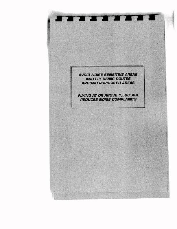
25 AIRCRAFT NOISE Aircraft noise is an increasingly sensitive issue, particularly in the Hawaiian Islands. Specific noise-abatement procedures have been developed for Kahului (OGG) and Hilo (ITO) airports and are included with the listing for each airport. However, most airports are near noise-sensitive areas, and extra caution is requested of pilots in minimizing the noise signature of their operations. Pilots should avoid overflying populated areas wherever possible, and, if overflight is unavoidable, should use the highest altitude practical. If altitude is restricted due to arrival/departure procedures or cloud clearance, then pilots should consider using reduced power settings, consistent with safe operations. Sensitivity to noise extends beyond residential and other populated areas. Pilots should also use caution to minimize noise impact on wilderness areas by considerate use of altitude and power settings, where feasible. AVOID NOISE SENSITIVE AREAS AND FLY USING ROUTES AROUND POPULATED AREAS FLYING AT OR ABOVE 1,500' AGL REDUCES NOISE COMPLAINTS 21
26 LEGEND Voluntary Noise Abatement Areas* Recommended Avoidance Areas * Established in the Voluntary Helicopter Noise Abatement Program, Hawaii State Helicopter System Plan and includes noise avoidance areas. Noise Abatement Areas ISLAND OF HAWAII 22
27 Noise Abatement Areas ISLAND OF KAUAI LEGEND Voluntary Noise Abatement Areas* Recommended Avoidance Areas * Established in the Voluntary Helicopter Noise Abatement Program, Hawaii State Helicopter System Plan and includes noise avoidance areas. 23
28 Noise Abatement Areas ISLAND OF MAUI 24 LEGEND Voluntary Noise Abatement Areas* Recommended Avoidance Areas HALEAKALA NATIONAL PARK Public law prohibits flight of VFR helicopters or fixed-wing aircraft below 9500 feet MSL over the following areas in Haleakala National Park: Haleakala Crater, Crater Cabins, the Scientific Research Reserve, Halemanu Trail,Kaupo Gap Trail or any designated tourist viewpoint. * Established in the Voluntary Helicopter Noise Abatement Program, Hawaii State Helicopter System Plan and includes noise avoidance areas.
29 LEGEND Voluntary Noise Abatement Areas* Recommended Avoidance Areas * Established in the Voluntary Helicopter Noise Abatement Program, Hawaii State Helicopter System Plan and includes noise avoidance areas. Noise Abatement Areas ISLAND OF OAHU 25
30 HAWAII COUNTY AIRPORTS Airport District Manager (ITO, KOA, MUE, UPP) P.O. Box 1660, Kailua-Kona, HI HILO INTERNATIONAL AIRPORT, PHTO (ITO), Hilo, Hawaii Manager... Telephone Hawaii Airport Security Latitude/Longitude N / W From City... 2 miles E of Hilo Airport Area... 1,007 Acres Airfield: Elevation... 38' MSL Runways (9,800'x150', asphalt - grooved) 3-21 (5,600'x150', asphalt - grooved) Lights... Beacon, obstruction, taxiway, wind sock, runway, VASI, ODALS Rwy 8, VASI, MALSR Rwy 26, VASI, REIL Rwy 3 Communications and Navigational Aids: Control Tower... Hilo Tower ( L) Frequencies... ATIS: ( L) TWR/CTAF APP/DEP: 119.7/ ( L) RCO (HNL AFSS) 122.6, 122.2, 122.1R Navaids... VORTAC 116.9, ITO, Chan 116, 2.1 nm from field ILS/DME110.7, I-ITO, Chan 44 Airspace: Class D service effective L other times Class E Traffic Pattern Altitude: Small Aircraft 800' MSL Large Aircraft 1,500' MSL or as directed by ATC ASOS: (808) (continued on next page) PHTO 26 ITO
31 Remarks: Services... Fuel 100 Oct, Jet-A, minor maint Fuel: Air Service (808) , UNICOM (Jet-A, AvGas-100 octane) Bradley Pacific (808) , UNICOM (Jet-A) Century Aviation (808) , UNICOM (Jet-A) Meals & Transportation... Restaurant, taxi, car rental Crash/Fire... FAR 139 Index C, 24 hours No jet operations on Rwys 3-21 between L. Rwy Ø3-21: Max auth landing weight: S-120, D-200, DT-360. Rwy Ø8-26: Max auth landing weight: S-115, D-185, DT-350. Rwy and approach light radio controlled on when tower closed. Transient parking at West Ramp. Operators of large aircraft should make prior arrangements with Airport Manager. PPR from Airport Manager for transportation of Class A and B explosives, and hazardous materials in and out of ITO. Avoid routes over Hawaiian Acres, Puna and Kurtistown areas. Flights at 1,500' AGL significantly reduces noise complaints. CAUTION: High volume traffic SSE of helicopter tours of volcano areas. PHTO 27 ITO
32 PHTO 28 ITO
33 PHTO 29 ITO
34 PHTO 30 ITO
35 KONA INTERNATIONAL AIRPORT at KEAHOLE, PHKO (KOA), Keahole, Hawaii Manager... Telephone Hawaii Airport Security Latitude/Longitude N / W From City miles NW of Kailua Airport Area... 2,700 Acres Airfield: Elevation... 47' MSL Runway (11,000'x150', asphalt - grooved) Lights... Beacon, obstruction, runway, PAPI MALSR Rwy 17 PAPI Rwy 35 Communications and Navigational Aids: Control Tower... Kona Tower ( L) Frequencies... ATIS: ( L) Clearance Delivery: ( L) TWR/CTAF RCO (HNL AFSS) 121.1R, 115.7T, Navaids... VORTAC 115.7, IAI,, Chan 104, 5.2 nm from field ILS/DME 109.7, I-KOA, Chan 34 Airspace: Class D service effective L other times Class G Traffic Pattern Altitude: Small Aircraft 800' MSL Large Aircraft 1,500' MSL ASOS: (808) (continued on next page) PHKO 31 KOA
36 Remarks: Services... Fuel 100 Oct, Jet-A, minor maint Fuel: Air Service (808) , UNICOM (Jet-A) Bradley Pacific (808) , UNICOM (Jet-A) Century Aviation (808) , UNICOM (Jet-A, AvGas- 100LL) Meals & Transportation... Restaurant, taxi, car rental Crash/Fire... FAR 139 Index D, 24 hours Runway/taxiway lights pilot radio controlled when tower closed. Aircraft parking west of control tower restricted to 30,000 lbs. PPR from Airport Manager for transportation of Class A and B explosives, and hazardous materials in and out of KOA. Maximum Authorized Landing Weight: S-75, D-200, DT-400, DDT-850. Mid-air collision potential is high between the 295 and 330 degree radials of the Kona VORTAC out to 20 nm DME. Radar advisories from HNL Center on are advised. PHKO 32 KOA
37 PHKO 33 KOA
38 PHKO 34 KOA
39 WAIMEA-KOHALA AIRPORT, PHMU (MUE), Kamuela, Hawaii Attendant... Telephone Hawaii ( L) Latitude/Longitude N / W From City miles SSW of Kamuela Airport Area Acres Airfield: Elevation... 2,671' MSL Runway (5,197'x100', asphalt) Lights... Beacon, obstruction, windsock, MIRL, VASI, REIL Rwy 4-22 Communications and Navigational Aids: Control Tower... None Frequencies... CTAF: FSS: 1(HNL FSS) 122.1R, 113.3T Navaids... VOR/DME: 113.3, MUE, Chan 80 on field Airspace: Class E service M - F L other times Class G Traffic Pattern Altitude: Small Aircraft 3,500' MSL Large Aircraft 4,200' MSL AWOS-3: VHF 120.0, (808) Remarks: Services... None Fuel: Douglas Aircraft (808) , 100LL Meals & Transportation... None (transportation by prior arrangement) Crash/Fire... One vehicle, 100 gal RON pilots park aircraft in designated area and use gate SW of firehouse. High tension wires 1,000' from approach end of Rwy 4. PPR for transient parking. PPR from Airport Manager (telephone ) for transportation of Class A and B explosives and hazardous materials in and out of MUE. Keep traffic pattern SE of Rwy. Maximum Authorized Landing Weight: S-55, D-90, DT-150. PHMU 35 MUE
40 PHMU 36 MUE
41 UPOLU AIRPORT, PHUP (UPP), Hawi, Hawaii Attendant... Unattended Latitude/Longitude N / W From City... 3 miles NW of Hawi Airport Area Acres Airfield: Elevation... 96' MSL Runway (3,800'x75', asphalt) Lights... MIRL, beacon, wind sock, PAPI Rwys 7-25 Communications and Navigational Aids: Control Tower... None Frequencies... CTAF: FSS: (HNL AFSS) 122.1R, 112.3T, Navaids... VORTAC UPP Chan 70, 4 nm to field Airspace: Class G Traffic Pattern Altitude: Small Aircraft 800' MSL Large Aircraft 1,500' MSL Remarks: Services... None Meals & Transportation... None Crash/Fire... None Runway lights radio-controlled by five clicks on No standby power for lights. PPR for transient parking call (808) PPR from Airport Manager (telephone ) for transportation of Class A and B explosives and hazardous materials in and out of UPP. Maximum Authorized Landing Weight: S-30. PHUP 37 UPP
42 PHUP 38 UPP
43 KAUAI COUNTY AIRPORTS Airport District Manager (LIH, PAK, HIØ1) 3901 Mokulele Loop, Box 6, Lihue, HI LIHUE AIRPORT, PHLI (LIH), Lihue, Kauai Manager... Telephone Lihue District Manager... (PAK, LIH & HIØ1) 3901 Mokulele Loop, Box 6, Lihue, HI Airport Security Latitude/Longitude N / W From City miles E of Lihue Airport Area Acres Airfield: Elevation ' MSL Runways (6,500'x150', asphalt - grooved) (6,500'x150', asphalt - grooved) Lights... Beacon, obstruction, runway, taxiway, RWY MIRL RWY 3 - PAPI, REIL RWY 21 - VASI, REIL RWY HIRL RWY 17 - PAPI, REIL RWY 35 - PAPI, MALSR Communications and Navigational Aids: Control Tower... Lihue Tower ( L) Frequencies... TWR/CTAF Helicopters: ( L) ATIS: ( L) Ground: ( L) RCO (HNL AFSS) 122.6, 113.5T, 122.1R Navaids... VORTAC 113.5, LIH, Chan 82 on field ILS/DME 110.9, I-ILH, Chan 46 Airspace: Class D service effective L other times Class E Traffic Pattern Altitude: Single Engine 1,000' MSL Multi Engine 1,500' MSL ASOS: (808) (continued on next page) PHLI 39 LIH
44 Remarks: Services... Fuel 100 Oct, Jet-A Fuel: Air Service (808) , UNICOM (Jet-A - 100LL) Bradley Pacific (808) , UNICOM (Jet-A) Century Aviation (808) , UNICOM (Jet-A) Meals & Transportation... Restaurant, taxi, car rental, limousine Crash/Fire... FAR 139 Index C, 24 hours Transient parking limited, contact Airport Manager for extended stay. Procedures: Observe preferred VFR routings to avoid IFR traffic. VFR aircraft inbound to Lihue from the east contact Honolulu Center by mid-channel. VFR aircraft departing Lihue via runway 3/35 eastbound, fly outbound on or north of LIH 105 degree radial until 25 miles east. CAUTION: Extensive helicopter traffic and birds in vicinity of the airport. Report all bird strikes to Animal Damage Control at (808) Maximum Authorized Landing Weight: RWY 3-21 RWY S D DT DC DC DDT Informal Runway Use Program in effect. Refer to Pacific Chart Supplement. WARNING: Intersection departures from taxiway D on Rwy is not authorized PHLI 40 LIH
45 PHLI 41 LIH
46 PHLI 42 LIH
47 PORT ALLEN AIRPORT (PAK), Hanapepe, Kauai Manager (unattended)... Telephone Lihue District Manager... (PAK, LIH & HIØ1) 3901 Mokulele Loop, Box 6, Lihue, HI Latitude/Longitude N / W From City... 1 mile SW of Hanapepe Airport Area Acres Airfield: Elevation... 24' MSL Runways (2,450'x60', asphalt) Lights... None Communications and Navigational Aids: Control Tower... None Frequencies... CTAF: RCO (HNL AFSS) 122.6, 122.1R, 113.5T Navaids... VORTAC 115.4, SOK, Chan nm from airport Airspace: Class G Traffic Pattern Altitude: 800' MSL Remarks: Services... None Meals & Transportation... None Crash/Fire... None Helicopter & ultralight aircraft traffic. Airport restricted by owner to aircraft weighing less than 12,500 lbs. Avoid overflight of salt ponds, state recreational beach park, residential and commercial areas N of airfield. Maximum Authorized Landing Weight: S PAK
48 44 PAK
49 PRINCEVILLE AIRPORT (HIØ1), Princeville, Kauai (Private) Manager (unattended)... Telephone Manager... Princeville Corporation P.O. Box 3040 Princeville, HI Latitude/Longitude N / W From City... 3 miles E Airport Area Acres Airfield: Elevation ' MSL Runway (3,560'x 40', asphalt) Rwy 5 Trees Rwy 23 Pole Communications and Navigational Aids: Control Tower... None Frequencies... CTAF: State intentions on frequency before landing RCO (HNL AFSS) Navaids... VORTAC LIH Chan nm to field Airspace: Class G Traffic Pattern Altitude: 1100' MSL Remarks: Services... None Meals & Transportation... Amelia s Restaurant upstairs terminal. Avis Car Rental Crash/Fire... None CAUTION: Numerous helicopter operations in vicinity. Restrictions: WARNING: Day VFR operations only. Pure jet powered aircraft and helicopters (other than Heli USA helicopters) are prohibited from using the airport, except in cases of emergency. Prior permission required for landing, contact Princeville Corporation at (808) for information and to coordinate payment of landing fee. No overnight parking. 45 HIØ1
50 46 HIØ1
51 MAUI COUNTY AIRPORTS (Molokai, Lanai, Maui) Airport District Manager (LUP, MKK, LNY, OGG, HNM, JHM) Kahului Airport, Kahului, HI KALAUPAPA AIRPORT, PHLU (LUP), Kalaupapa, Molokai Attendant... Telephone Molokai (M-F, L) Latitude/Longitude N / W From City... 1 mile N of Kalaupapa Airport Area Acres Airfield: Elevation... 24' MSL Runway (2,700'x75', asphalt) Lights... MIRL and Beacon (Phone request ) PAPI Rwy 5 Communications and Navigational Aids: Control Tower... None Frequency... CTAF: RCO (HNL AFSS) 122.R, 116.1T Airspace: Class G Traffic Pattern Altitude: 800' MSL Remarks: Services... None Meals & Transportation... None Crash/Fire... One trailer crew may be available. DAY VFR ONLY. Permission required from State Dept. of Health, Honolulu to enter Kalaupapa Settlement. Military helicopter operations during daylight hours. Circle before landing. CAUTION: Possible wild animals around the vicinity of the airport. Deep ruts along northeast runway shoulder caused by wild boars. October - May: large waves impacting shoreline resulting in salt water sprays 40' high. Maximum Authorized Landing Weight: S-17. PHLU 47 LUP
52 PHLU 48 LUP
53 MOLOKAI AIRPORT, PHMK (MKK), Kaunakakai, Molokai Attendant... Telephone Molokai ( L) Latitude/Longitude N / W From City miles NW of Kaunakakai Airport Area Acres Airfield: Elevation ' MSL Runways (4,494'x100', asphalt - grooved) Displaced threshold Rwy (3,118'x100', asphalt) Displaced threshold Rwy 17 Lights... (5-23)* PAPI REIL Rwy 5 MIRL Communications and Navigational Aids: Control Tower... Molokai Tower ( L) Frequencies... TWR/CTAF ATIS: ( L) Ground ( L) RCO (HNL AFSS) 122.1R, 116.1T Navaids... VORTAC 116.1, MKK, Chan 108, 3.8 nm from field Airspace: Class D service L other times Class G Traffic Pattern Altitude: Small Aircraft 1,250' MSL Large Aircraft 1,950' MSL ASOS: (808) Remarks: Services... None Meals & Transportation... Snack bar, taxi, car rental Crash/Fire... FAR 139 index A (0530 to 1930L or to last scheduled flight plus 15 minutes) Lighted windsock. *Rwy 5 PAPI NOT AUTHORIZED beyond 1.8 nm from threshold due to rapidly rising terrain. Maximum Authorized Landing Weight: S-30, D-48 (continued on next page) PHMK 49 MKK
54 AREA NOTICE - MOLOKAI ISLAND: Both the north and south shores of Molokai accommodate a large volume of air commuter, tour, and training aircraft between 1,000' and 3,500' MSL which fly at 1,000', 2,000' and 3,000' westbound and 1,500', 2,500' and 3,500' eastbound. All traffic transiting the area is advised to observe these altitudes and remain clear of the Molokai ATA. Monitor along both shorelines and broadcast position, direction of flight, and altitude at Ilio Point, Kalaupapa, Wailau Valley, Laau Point, Cape Halawa and Kamalo. PHMK 50 MKK
55 LANAI AIRPORT, PHNY (LNY), Lanai City, Lanai Attendant... Telephone Lanai ( L) Airport Security Latitude/Latitude N / W From City... 4 miles SW of Lanai City Airport Area Acres Airfield: Elevation... 1,308' MSL Runway (5,000'x150', asphalt) Lights... Obstruction, wind cone, runway, beacon, VASI Rwy 3 / PAPI Rwy 21 Communications and Navigational Aids: Control Tower... None Frequencies... CTAF: HNL DEP/ARR CON RCO (HNL AFSS) 122.2, 121.1R, 117.7T Navaids... VORTAC 117.7, LNY, Chan nm from field NDB: LLD 353 on field ILS/DME 111.1, I-LNY, Chan 48 (rwy 03) Airspace: Class E service Sun., Thur., Fri L, Mon L other times Class G Traffic Pattern Altitude: Small Aircraft 2,100' MSL Large Aircraft 2,800' MSL AWSS: (808) Remarks: Services... None Fuel: Air Service (808) , UNICOM (Jet-A) Bradley Pacific (808) , UNICOM (Jet-A) Meals & Transportation... None Crash/Fire... FAR 139 index A ( L or last scheduled flight plus 15 minutes) Left traffic only. Announce taxi intentions prior to taxiing onto the active runway. PPR for parking over 1 hr. Small aircraft park on SW side of ramp. Call Maui Airports District Manager at or Airport Operations Control at (24 hours) for PPR. Maximum Authorized Landing Weight: S-45, D-70, DT-110. PHNY 51 LNY
56 PHNY 52 LNY
57 HANA AIRPORT, PHHN (HNM), Hana, Maui Attendant... Telephone Maui M-F ( L) Latitude N / W From City... 3 miles NW of Hana Airport Area Acres Airfield: Elevation... 78' MSL Runways (3,606'x100', asphalt) Lights... Runway, wind sock, rotating beacon Communications and Navigational Aids: Control Tower... None Frequencies... CTAF: RCO (HNL AFSS) Airspace: Class G Traffic Pattern Altitude: Small Aircraft 800' MSL Large Aircraft 1,500' MSL AWOS: VHF , (808) Remarks: Services... None Meals & Transportation... None (car rental by prior arrangement) Crash/Fire... One vehicle with 100 gal light water, Volunteer crew. VFR operations only. Airport CLOSED to helicopters sunset to sunrise except by PPR (808) Helicopter pilot training operations will be conducted at the approach end of runway 26. Runway lights activated by 5 clicks on CAUTION: Aerobatic area north of downwind leg. Parachute jumping and ultralight operations within the airport area. Maximum Authorized Landing Weight: S-34, D-48, DT-80. PHHN 53 HNM
58 PHHN 54 HNM
59 KAHULUI AIRPORT, PHOG (OGG), Kahului, Maui Manager... Telephone Maui Airport Operations Center (24 hours) Airport Security Latitude/Longitude N / W From City miles E from Kahului Airport Area... 1,391 Acres Airfield: Elevation... 54' MSL Runways (6,955'x150', asphalt - grooved) 5-23 (4,990'x150', asphalt - grooved) Lights... Beacon, runway, taxiway, obstruction, VASI Rwys 02, 05, 20, MalS/R Rwy 02 Communications and Navigational Aids: Control Tower... FAA Maui Tower ( L) Frequencies... TWR/CTAF ATIS: ( L) CLR DEL: ( L) GND: ( L) DEP/APP N S ( L) Navaids... VORTAC 115.1, OGG, Chan 90 on field ILS I-OGG: Rwy 2 NDB: VVI nm to field Airspace: Class C service L contact Maui App Traffic Pattern Altitude: Small Aircraft 800' MSL Large Aircraft 1,500' MSL ASOS: (808) Remarks: Services... Fuel 100 Oct, Jet-A and Minor A&P Fuel: Air Service (808) , UNICOM (Jet-A - 100LL) Bradley Pacific (808) , UNICOM (Jet-A) Meals & Transportation... Restaurant, taxi, car rental Crash/Fire... FAR 139 index D, 24 hours (continued on next page) PHOG 55 OGG
60 Transient aircraft park on East Ramp near Airport Fire Station. Extensive helicopter operations on and from East Ramp. Avoid noise sensitive areas (Spreckelsville, Haiku, Paia, etc.). RWY 5-23, Max. Auth. Landing Weight: S-130, D-170, DT-270 RWY 2-20, Max. Auth. Landing Weight: S-130, D-170, DT-360 PHOG 56 OGG
61 PHOG 57 OGG
62 PHOG 58 OGG
63 KAHULUI, MAUI Shown are the most heavily traveled routes for high performance aircraft arriving and departing Kahului Airport, Maui. Light plane pilots flying VFR in these areas should maintain an alert lookout and monitor Maui Approach Control frequency. Aircraft transiting north of the Kahului Airport in VFR conditions are requested to remain at least 8NM north of the airport at or below 4500 ft. if westbound, 3500 ft. if eastbound, or following the shoreline at or below 2500 ft. and be responsive to routing changes issued by Maui Approach Control or Maui Tower. The area depicted as ALFA is a light aircraft local training area. Area is outside Kahului Airport Class C airspace. Aircraft training in area normally operate at or below 3000 ft. and monitor Maui Approach Control. PHOG 59 OGG
64 LEGEND VFR CHECK POINTS FLOOR IN HUNDREDS OF FEET MSL CEILING IN HUNDREDS OF FEET MSL HALEAKALA NATIONAL PARK Public law prohibits flight of VFR helicopters or fixed-wing aircraft below 9500 feet MSL over the following areas in Haleakala National Park: Haleakala Crater, Crater Cabins, the Scientific Research Reserve, Hallemauu Trail, Kaupo Gap Trail or any designated tourist viewpoint. CLASS C AIRSPACE ENTRY PROCEDURES VFR aircraft proposing to enter Kahului Airport Class C Airspace are required to contact ATC prior to entry. Initial contact: refer to charted VFR check points or 10 DME from the OGG VORTAC. Initial calls in close proximity to the airspace boundary may receive instructions to remain clear of Charlie airspace and standby. Initial calls from the more distant check points are preferred. Frequencies: North of V , South of V PHOG 60 OGG
65 KAPALUA AIRPORT, PHJH (JHM), Kapalua, Maui Attendant... Telephone Maui Latitude N Longitude W From City... 7 miles N of Lahaina Airport Area Acres Airfield: Elevation ' MSL Runways (3,000'x100', asphalt) Lights... None Communications and Navigational Aids: Control Tower... State operated Unicom (30 min. after sunrise to 1830L) Frequency... Unicom Airspace: Class E service effective L other times Class G Traffic Pattern Altitude: 1500' MSL AWOS: VHF , (808) Remarks: Services... None Meals & Transportation... None Crash/Fire... FAR 139 Index A L Maximum Authorized Landing Weight: D-44. Limitations/Restrictions: Contact (Kahului Airport Operation) Airport is restricted to Part 121 and 135 FAR operators with prior permission. No helicopter operation permitted. No jet powered aircraft allowed. No practice or training flights allowed. Special noise level standards for aircraft operated at the airport. Restriction on amount of daily flights depending on aircraft size. Procedures: Monitor mhz transiting the area and broadcast position, direction of flight and altitude at Nakalele Point, Lahaina, Shipwreck Beach and Kamalo. CAUTION: Numerous air carrier operations into and out of area from ground to 8,000'. Both the north and south shores of Maui accommodate a large volume of air commuter, tour and training aircraft between 1,000', 2,500' and 3,500' eastbound. PHJH 61 JHM
66 PHJH 62 JHM
67 OAHU COUNTY AIRPORTS Airport District Manager (HDH, JRF, HNL) Honolulu International Airport, Honolulu, HI HONOLULU INTERNATIONAL AIRPORT (HNL), Honolulu, Oahu Manager... Telephone Honolulu , , Airport Security Latitude/Longitude N / W From City... 4 miles WSW from Honolulu Airport Area... 4,220 Acres Airfield: Elevation... 13' MSL Runways... 8L - 26R (12,300'x150', asphalt - grooved) 8R - 26L (12,000'x 200, asphalt - grooved) 4R - 22L (9,000'x150', asphalt - grooved) 4L - 22R (6,952'x150', asphalt) Waterway 8 (5,000'x 300') Waterway 4-22 (3,000 x150 ) Lights... HIRL (Rwy 8-26 and 4R - 22L) MIRL (Rwy 4L - 22R) VASI (Rwy 4R, 4L, 8R, 22L, 26R, 26L) REIL (Rwy 26R, 22R, 4R, 4L) MALSR (Rwy 4R, 8L) MALSF (Rwy 26L) Communications and Navigational Aids: Control Tower... Honolulu Tower (24 hours) Frequencies... ATIS: CLR DEL: GND: TWR: / APP: DEP (West) (East) RCO (HNL AFSS) 122.6, 122.2, 122.1R, 114.8T Navaids... VORTAC 114.8, HNL, Chan 95 on field Ewabe NDB: 242, 7.1 nm from field ILS/DME (4R): 110.5, I-IUM, Chan 42 ILS (8L): 111.7, I-HNL LDA/DME 109.1, I-EPC (26L), Chan 28 Airspace: Class B (continued on next page) PHNL 63 HNL
68 Traffic Pattern Altitude: Overhead 2,000' MSL (Jet traffic) Right traffic pattern Rwy 4R 600' MSL (Tower approval required) or assigned by ATC Remarks: Services... Major A&P, fuel, oxygen Fuel: Air Service (808) , UNICOM (Jet-A, AvGas- 100LL) Bradley Pacific (808) , UNICOM (Jet-A) Century Aviation (808) , UNICOM (Jet-A) Douglas Aircraft - (808) (100LL) Meals & Transportation... All types of meal service and transportation Crash/Fire... FAR 139 index E, 24 hours Functioning two-way radio and transponder required. United States landing rights airport. Customs, immigration, public health, plant inspection and quarantine station. Arresting gear Rwy 4R/22L, 8R/26L, 26R. All aircraft desiring gate assignment or parking location must contact ramp control on Due to location of tower, controllers are unable to determine whether aircraft are on the correct final approach for Rwys 4L/4R and 22L/22R. Due to non-visibility tower is unable to determine if the following areas are clear of obstructions and/or traffic: commuter ramp, taxiways Kilo and Oscar, portions of taxiway RB and interisland ramp, aircraft storage spot uniform, east of fire station #1. Transient parking is limited. Operators of large aircraft should make prior arrangement with the airport manager. Turn landing lights on while in the airport traffic area. During VFR tradewind conditions, non-jet aircraft will be vectored to Rwy 4R/L traffic pattern. Pilots requesting Rwy 8L will normally be expected to fly the ILS approach procedure. Visual approaches to Rwys 22L/R and 26R are expected to remain at traffic pattern altitudes as long as possible before beginning descent for landing. Maximum Authorized Landing Weight: Rwy 8L/26R S-100, D-200, DT-400, DDT-700. Rwy 8R/26L S-80, D-170, DT-488, DDT-780. Rwy 4L/22R S-100, D-200, DT-400, DDT-850. Rwy 4R/22L S-100, D-200, DT-400, DDT-850. PHNL 64 HNL

69 PHNL HONOLULU INTERNATIONAL AIRPORT OAHU 65 HNL
70 LAND AND HOLD SHORT OPERATIONS Simultaneous take-offs and landings on intersecting runways are common at Honolulu. It is the responsibility of pilots to determine whether they can comply with a hold-short restriction. Pilots must read back all hold-short instructions. WAKE TURBULENCE Honolulu Airport is served by many large and heavy turbojet aircraft. VFR pilots are reminded that it is their responsibility to use proper technique and avoid wake turbulence. SEALANE OPERATIONS Pilots desiring to use Sealane 4, 8, 22 at Keehi Lagoon shall be briefed by the FAA Honolulu Control Facility Admin Office at (808) prior to actual use. Conditions for use: Operations shall be conducted in VFR conditions only. Operations shall be conducted during daylight hours only. Operations shall be conducted to Sealane 4/8/22 only. Operations shall be confined to landings/departures only. No pattern work authorized. All arrivals/departures shall adhere to Honolulu Class B Airspace VFR Departure and Arrival Routes as published unless otherwise instructed by Air Traffic Control. Pattern Altitudes: North arrival: 800' MSL (small aircraft only) South arrival: 1,000' MSL small aircraft; 1,500' MSL large aircraft. CAUTION: Recreational boating activities in vicinity of the Sealane. PHNL 66 HNL
71 HONOLULU TERMINAL AREA (CLASS B) OPERATING RULES AND EQUIPMENT REQUIREMENTS Regardless of weather conditions, ATC authorization is required prior to operating within Honolulu Class B Airspace. Pilots should not request such authorization unless the following requirements are met: A two-way radio capable of communicating with ATC on appropriate frequencies. A 4096 code transponder with Mode C altitude reporting. The pilot in command of a civil aircraft must hold at least a private pilot certificate or be a student pilot who has a logbook endorsement by an authorized flight instructor within the preceding 90 days, certifying competency to depart and land at Honolulu International Airport as well as to transit through Class B Airspace. Procedures: IFR Aircraft operating within Honolulu Class B Airspace shall be operated in accordance with current IFR procedures. A clearance for a visual approach is not authorization for an aircraft to operate below the designated floors of Class B Airspace. VFR Arriving aircraft or aircraft desiring to transit Class B Airspace should contact Honolulu Approach Control on the frequency depicted for the sector of flight with reference to the geographical center of the airport. Pilots should state on initial contact their position, direction of flight, and destination, and verify that they have received the current ATIS transmission. If holding of VFR aircraft is required, the holding point will be specified by ATC and will be a prominent geographical fix, landmark or VOR radial. Aircraft departing HNL are requested to contact Honolulu clearance delivery prior to taxing. Pilots should state the departure procedure requested and confirm that they have received the current ATIS. Aircraft desiring to transit Class B Airspace will obtain clearance on an equitable first-come first-served basis. ATC Procedures: All aircraft will be controlled and separated while operating within Class B Airspace, except helicopters may not be separated from other helicopters. Although radar separation will be the primary standard used, approved visual and other nonradar procedures will be applied as required or deemed appropriate. Traffic information on observed but unidentified radar targets will be provided on a workload permitting basis to aircraft operating outside of Class B Airspace. NOTE: This service does not relieve pilots of their responsibility to see and avoid other traffic. To maintain appropriate terrain and obstruction clearance, and to remain in VFR weather conditions remains the responsibility of the pilot in command. Whenever compliance with an assigned heading or altitude is likely to compromise pilot responsibility, ATC shall be advised and a revised clearance obtained. PHNL 67 HNL
72 NO AIRCRAFT IS AUTHORIZED TO ENTER CLASS B AIRSPACE UNTIL CLEARED BY ATC. PHNL 68 HNL
73 DILLINGHAM AIRFIELD, PHDH (HDH), Mokuleia, Oahu Attendant... Telephone Honolulu ( L) Latitude/Longitude N / W From City miles W of Haleiwa Airport Area Acres Airfield: Elevation... 15' MSL Runways (9,007'x 75', asphalt) Rwy 8 displaced threshold 1,993' Rwy 26 displaced threshold 1,995' Lights... None Communications and Navigational Aids: Control Tower... State operated Unicom L daily Frequency... Unicom RCO (HNL FSS) Airspace: Class G Traffic Pattern Altitude: 800' MSL Remarks: Services Toilet facilities, public telephone, picnic table, fuel 100LL, Jet-A Fuel: Honolulu Soaring (808) (Jet-A, 100LL) Meals & Transportation... None Crash/Fire... One vehicle 100 gal light water and dcp hand extinguishers manning variable Maximum Authorized Landing Weight: S-40, D-152, DT-180. Extensive glider operations. Give gliders right of way. Extensive parachute operations. Give parachutists right of way. Limitations: Open to civil aircraft for DAY VFR ONLY. Walking on or across the runway is prohibited. (continued on next page) PHDH 69 HDH
74 Procedures: All aircraft must contact Dillingham Unicom prior to entering the traffic pattern and maintain contact when operating in the Dillingham area. All traffic north of runway. No landing without unicom contact during hours of unicom operation. It is common practice to call unicom on base leg in addition to the call when entering the pattern. A 5,000' by 75' runway for powered aircraft is identified by standard airport pavement markings. The powered aircraft thresholds have been displaced 2,000' to provide runway for sailplane operations. Powered aircraft shall keep base leg in close, and cross the airport boundary fence on final approach at or above 600' MSL in order to assure safe separation from sailplanes using the first 2,000' (short of the displaced threshold). Standard pattern entry is illustrated. CAUTION: Extensive glider operations and parachute jumping off Rwy 8 and Rwy 26. Aerobatic training area off-shore above the downwind leg 1,500' MSL and above. When transiting the area, cross the field above 2,000' MSL. No civil operations between sunset and sunrise. Extensive night operations by military helicopters. Glider Operations: Gliders are normally air-towed and routinely depart the traffic pattern to the South. (Right turn after takeoff Rwy 8; Left turn after takeoff Rwy 26). Gliders normally fly the ridge line to the South or the airport, within 5nm. Most gliders are not radio equipped. The powered aircraft towing the gliders have radios and routinely use the glider traffic pattern, entering the traffic pattern from the South. Sky Dive Operations: Extensive parachute operations occur daily at 16,000' and below. Parachutists normally exit the aircraft upwind of the airport and during strong winds may exit as far as 2 nautical miles from the drop zone. Parachutes are usually opened between 2,000' and 4,500' altitude, and then flow to the drop zone entering an abbreviated left traffic pattern (Rwy 8) or right traffic pattern (Rwy 26). During light and no wind conditions, the parachutes may open directly above the airport and adjacent beach area. PHDH 70 HDH
75 PHDH DILLINGHAM AIRFIELD OAHU 71 HDH
76 KALAELOA AIRPORT, PHJR (JRF), Kapolei, Oahu Attendant... Telephone /5590, Hours of Operation L (State Maintenance) Airport Security... Telephone /9295 (24 hours) Latitude/Longitude N / W From City... 2 miles S from Kapolei Airport Area Acres Airfield: Elevation... 33' MSL Runways... 04R-22L (8,000'x 200', asphalt) 04L-22R (4,500'x 200', asphalt) (6,000'x 200', asphalt) Lights... HIRL (all runways), beacon Communications and Navigational Aids: Control Tower... Kalaeloa Tower ( L) Frequencies... TWR/CTAF ATIS CLR DEL GRD Navaids... VORTAC HNL Chan 95, 7.8 nm from airport NDB (MWH/LOM) Ewabe 242 Airspace: Class D Service L other times Class E Traffic Pattern Altitude: Small Aircraft 800' MSL Large Aircraft 1,000' MSL ASOS: (808) (Broadcast on ATIS L, nightly) Remarks: Services... None Meals & Transportation... None Crash/Fire hours (NAVAIR 0800 R-14 NATOPS US Navy Aircraft Firefighters and Rescue Manual, Category II Airfield) Index B equivalent Departures not authorized on runway 29. Arrivals not authorized on Runway 11. ATIS (ASOS observations voice broadcast L, nightly) (continued on next page) PHJR 72 JRF
77 Public restroom and telephone facilities available in first floor of air traffic control tower building. Airport is located under the final approach path Runway 08L Honolulu International Airport and HNL Class B Airspace. Do not overfly Campbell Industrial Park. Extreme hazards exists, gaseous exhaust plumes and flames may rise to over 267' AGL without warning! Left hand pattern (rwy 04L) recommended for single engine small aircraft only! PHJR 73 JRF
78 PHJR 74 JRF
79 PHNG 75 NGF
80 PHHI WHEELER AAF OAHU 76 HHI
81 EMERGENCY PROCEDURES A pilot in any emergency phase (uncertainty, alert, or distress) should do the following to obtain help: Set transponder to 7700 (unless squawking a discreet code and talking to a radar controller in that case use 7600 if radio contact has been lost). Tune to unless already communicating with a controller (or FSS) on a different frequency. Transmit MAYDAY, MAYDAY, MAYDAY (if distress) or PAN, PAN, PAN (if uncertainty or alert). Aircraft identification (repeat 3 times if calling on 121.5) Add the following if calling on Location Heading (true or magnetic state which one) True airspeed or estimated true airspeed (state which one) Altitude Fuel remaining in hours and minutes Nature of distress Pilot s intentions (ditch, crash landing, etc.) Assistance desired (fix, steer, bearing, escort, etc.) Two 10-second transmissions without voice, followed by aircraft identification (once) and OVER. Comply with instructions received. Accept the communications control offered to you by the ground radio station, silence interfering radio stations, and do not shift frequency or shift to another ground station unless absolutely necessary. Pilots on IFR flights experiencing two-way radio failure are expected to adhere to the procedures described in the appropriate FARs. 77
82 PILOTS SHOULD REMEMBER THE FOUR Cs: CONFESS your predicament to any ground radio station. Do not wait too long. Give SAR a chance! COMMUNICATE with your ground link and pass as much of the distress message on the first transmission as possible. We need information for the best SAR action! CLIMB if possible for better radar and DF detection. IF flying at low altitude, the chance for establishing radio contact is improved by climbing. Also the chances of alerting radar systems are sometimes improved by climbing or descending. NOTE: Climbing or descending under IMC conditions within controlled air space is not permitted except in EMERGENCY. Air traffic control will operate on the assumption that the provision of the FARs are being followed by the pilot. COMPLY with advice and instructions received. Assist the ground communications control station to control communications on the distress frequency on which you are working (as that is the distress frequency for your case). Tell interfering stations to maintain silence until you call. Cooperate! When a pilot is in doubt of his/her position, or feels apprehensive for his/her safety, he/she should not hesitate to request assistance. Search and Rescue facilities, including radar, radio and DF stations, are ready and willing to help. Delay has caused crashes and cost lives. Take action in a timely fashion! 78
83
a. Aeronautical charts DID THIS IN LESSON 2
 AIRMAN CERTIFICATION STANDARDS: REMOTE PILOT SMALL: You will know and be able to explain in writing or oral form the below tasks regarding AIRPORT OPERATIONS Task References Objective Task B. Airport Operations
NAVIGATION: CHARTS, PUBLICATIONS, FLIGHT COMPUTERS (chapters 7 & 8)
") NAVIGATION: CHARTS, PUBLICATIONS, FLIGHT COMPUTERS (chapters 7 & 8) LONGITUDE AND LATITUDE 1. The location of an airport can be determined by the intersection of lines of latitude and longitude. a. Lines
NAVIGATION: CHARTS, PUBLICATIONS, FLIGHT COMPUTERS (chapters 7 & 8) LONGITUDE AND LATITUDE 1. The location of an airport can be determined by the intersection of lines of latitude and longitude. a. Lines
Vertiport Chicago is a private facility, open to authorized users. Prior permission and/or landing reservations are required (PPR).
.") Heliport Information Vertiport Chicago is a private facility, open to authorized users. Prior permission and/or landing reservations are required (PPR). Location Identifier: 43IL Lat/Long: 41 51 47.3"N
Heliport Information Vertiport Chicago is a private facility, open to authorized users. Prior permission and/or landing reservations are required (PPR). Location Identifier: 43IL Lat/Long: 41 51 47.3"N
JACK EDWARDS NATIONAL AIRPORT (JKA) GULF SHORES, AL
 GULF SHORES, AL") OCTOBER 26-27, 2018 JACK EDWARDS NATIONAL AIRPORT (JKA) GULF SHORES, AL SPECIAL FLIGHT PROCEDURES EFFECTIVE: Thursday Oct 25, 2018 12:00 NOON CDT until 6:00 PM CDT Friday Oct 26, 2018 7:00 AM CDT until
OCTOBER 26-27, 2018 JACK EDWARDS NATIONAL AIRPORT (JKA) GULF SHORES, AL SPECIAL FLIGHT PROCEDURES EFFECTIVE: Thursday Oct 25, 2018 12:00 NOON CDT until 6:00 PM CDT Friday Oct 26, 2018 7:00 AM CDT until
 IFR 91.157 Must be instrument rated to fly special VFR at Night (civil twilight to civil twilight, sun 6 degrees below horizon) 91.159 Unless in a holding pattern of 2 minutes or less, VFR cruising altitude
Jeppesen Mobile FliteDeck VFR
 Airport Information CLEARWATER INTL (PIE) 10 Rwy9730 118.30 CTAF Location Name Fuel and Services Available Identifier Length of longest runway Frequency (public airports only) Airport Elevation 118.60
BFR WRITTEN TEST B - For IFR Pilots
 (61 Questions) (Review and study of the FARs noted in parentheses right after the question number is encouraged. This is an open book test!) 1. (91.3) Who is responsible for determining that the altimeter
NOTAM. Aircraft Owners and Pilots Association (AOPA) Fly-In Colorado Springs Airport (COS) Colorado Springs, CO SPECIAL FLIGHT PROCEDURES
 Fly-In Colorado Springs Airport (COS) Colorado Springs, CO SPECIAL FLIGHT PROCEDURES") NOTAM Aircraft Owners and Pilots Association (AOPA) Fly-In Colorado Springs Airport (COS) Colorado Springs, CO SPECIAL FLIGHT PROCEDURES EFFECTIVE 12:00 Noon Local Friday, September 25, 2015 Until 6:00
NOTAM Aircraft Owners and Pilots Association (AOPA) Fly-In Colorado Springs Airport (COS) Colorado Springs, CO SPECIAL FLIGHT PROCEDURES EFFECTIVE 12:00 Noon Local Friday, September 25, 2015 Until 6:00
KSMO HIGH. Santa Monica Muni Airport Santa Monica, California, United States
 Diagram #1: Airport Diagram with Monitors and Turbine Aircraft Hold Areas Aircraft Categories: A, B, C, D & E / Runways: 03 & 21 p. 1 of 7 NOISE ABATEMENT PROCEDURES by Whispertrack Diagram #2: Monitors
R-2515 R-2508 COMPLEX
 R-2515 R-2508 COMPLEX Edwards AFB PPR Briefing Edwards AFB and Edwards Class D Surface Area lie within Restricted Area 2515: R-2515 and Edwards Class D Surface Area contain many flight hazards for aircrews
STUDENT PILOT PRE-CROSS-COUNTRY WRITTEN EXAM
 DO NOT WRITE ON THIS TEST FEB 2013 STUDENT PILOT PRE-CROSS-COUNTRY WRITTEN EXAM This test is required prior to solo cross-country per AFMAN This test is not required if the student has passed the FAA Knowledge
Source: Chippewa Valley Regional Airport ASOS, Period of Record
 Chapter 1 Inventory Runway wind coverage is the percentage of time a runway can be used without exceeding allowable crosswind velocities. Allowable crosswind velocities vary depending on aircraft size
EFFECTIVE NOTAM KOUN SPECIAL FLIGHT PROCEDURES 09/08 NORMAN, OK
 KOUN WESTHEIMER AIRPORT NORMAN, OK 17 09/08 09/09 NOTAM SPECIAL FLIGHT PROCEDURES EFFECTIVE 12:00 Noon CDT until 7:30 PM CDT Thursday, September 7, 2017 7:00 AM CDT until 7:30 PM CDT Friday, September
SANTA FE MUNICIPAL AIRPORT (SAF) SANTA FE, NM
 SANTA FE, NM") SEPTEMBER 13-15, 2018 SANTA FE MUNICIPAL AIRPORT (SAF) SANTA FE, NM SPECIAL FLIGHT PROCEDURES EFFECTIVE: Thursday Sept 13, 2018 12:00 NOON MDT until 7:00 PM MDT Friday Sept 14, 2018 7:00 AM MDT until 7:00
SEPTEMBER 13-15, 2018 SANTA FE MUNICIPAL AIRPORT (SAF) SANTA FE, NM SPECIAL FLIGHT PROCEDURES EFFECTIVE: Thursday Sept 13, 2018 12:00 NOON MDT until 7:00 PM MDT Friday Sept 14, 2018 7:00 AM MDT until 7:00
EFFECTIVE NOTAM KGON 10/06 SPECIAL FLIGHT PROCEDURES GROTON, CT
 KGON GROTON-NEW LONDON AIRPORT GROTON, CT 17 10/06 10/07 NOTAM SPECIAL FLIGHT PROCEDURES EFFECTIVE 12:00 Noon EDT until 6:00 PM EDT Thursday, October 5, 2017 7:00 AM EDT until 6:00 PM EDT Friday, October
GENERAL INFORMATION Aircraft #1 Aircraft #2
 GENERAL INFORMATION Identification number: 2007075 Classification: Serious incident Date and time 1 of the 2 August 2007, 10.12 hours occurrence: Location of occurrence: Maastricht control zone Aircraft
DIRECCION DE PERSONAL AERONAUTICO DPTO. DE INSTRUCCION PREGUNTAS Y OPCIONES POR TEMA
 T E M : 0322 INSTRUTOR_DVNED_07_PROEDURES & IRPT OPS OD_PREG: P R E G U N T : RPT: 6436 n airport without a control tower lies within the controlled airspace of an airport with an operating tower. ccording
Cape Area Airports Standard Operating Procedures
 Cape Area Airports Standard Operating Procedures This air traffic control procedural document is provided for virtual air traffic control in the ZBW ARTCC of the VATSIM network only. It is not for real-world
UNIVERSITY OF ALABAMA FOOTBALL
 UNIVERSITY OF FOOTBALL SPECIAL AIR TRAFFIC PROCEDURES TUSCALOOSA, AL September 16, 2017 November 18, 2017 The following procedures will be implemented to enhance safety and minimize delays during the following
TABLE OF CONTENTS. 3 Airport Managers Notice, Arlington Airport Closures. 4 Air Show Operations, Arlington Area Frequencies
 2 In anticipation of the large number of aircraft operating to and from Arlington Municipal Airport during the Arlington Fly-In, the following procedures will be used to enhance safety and minimize air
1.1.3 Taxiways. Figure 1-15: Taxiway Data. DRAFT Inventory TYPICAL PAVEMENT CROSS-SECTION LIGHTING TYPE LENGTH (FEET) WIDTH (FEET) LIGHTING CONDITION
 WIDTH (FEET) LIGHTING CONDITION") 1.1.3 Taxiways EWN has an extensive network of taxiways and taxilanes connecting the terminal, air cargo, and general aviation areas with the runways as listed in Figure 1-15. A 50-foot wide parallel taxiway
1.1.3 Taxiways EWN has an extensive network of taxiways and taxilanes connecting the terminal, air cargo, and general aviation areas with the runways as listed in Figure 1-15. A 50-foot wide parallel taxiway
Chapter 9 - Airspace: The Wild Blue, Green & Red Yonder
 I5 Class G Airspace 38. [I4/3/3] What minimum visibility and clearance from clouds are required for VFR operations in Class G airspace at 700 feet AGL or lower during daylight hours? A. mile visibility
AIR LAW AND ATC PROCEDURES
 1 The International Civil Aviation Organisation (ICAO) establishes: A standards and recommended international practices for contracting member states. B aeronautical standards adopted by all states. C
VFR PHRASEOLOGY. The word IMMEDIATELY should only be used when immediate action is required for safety reasons.
 VFR PHRASEOLOGY 1. Introduction 1.1. What is phraseology? The phraseology is the way to communicate between the pilot and air traffic controller. This way is stereotyped and you shall not invent new words.
Class B Airspace. Description
 Class B Airspace Ref. AIM 3-2-3 and FAR 91.131 Surrounds certain large airports Within each Class B airspace area, there are multiple segments with different ceiling/floor altitudes. Example: 70/30 = ceiling
Whitsunday Airport. The pilot s gateway in the heart of the Whitsundays. Visiting Pilot s Guide
 Whitsunday Airport The pilot s gateway in the heart of the Whitsundays Visiting Pilot s Guide Airport Statistics & Services ERSA Reference: Situation: Elevation: Shute Harbour/Whitsunday. Lat 20 o 16 S
50 Ways to Improve Your Airport: Engaging Airport Management on Key Issues
 50 Ways to Improve Your Airport: Engaging Airport Management on Key Issues Tuesday, November 17, 2015 1:00 p.m. 2:00 p.m. PRESENTED BY: Charles D. Lamb, P.E. Airfield Lighting Image Source: Delta Airport
Town of East Hampton Airport 200 Daniel s Hole Road Wainscott, NY
 Town of East Hampton Airport 200 Daniel s Hole Road Wainscott, NY 11975 631.537.1130 2014 Noise Abatement The following Helicopter Noise Abatement Procedures have been developed in collaboration with the
Gleim Private Pilot Syllabus Fifth Edition, 3rd Printing Updates March 2016
 Page of Gleim Private Pilot Syllabus Fifth Edition, rd Printing Updates March 0 NOTE: Text that should be deleted is displayed with a line through it. New text is shown with a blue background. If you see
RADIO COMMUNICATIONS AND ATC LIGHT SIGNALS
 RADIO COMMUICATIOS AD ATC LIGHT SIGALS VI - A ITRODUCTIO RADIO LICESE RADIO EQUIPMET PHRASEOLOGY LOST COMMUICATIO Receiver Transmitter Both Departure - Operating in and out of a controlled airport, as
/ Aus n Wilkins / Deputy Air Traffic Manager Honolulu CF
 VATSIM NETWORK UNITED STATES DIVISION HONOLULU CF SUBJ: Approved Positions and Frequencies Table. This order prescribes the approved list of posi ons, callsigns, and frequencies for use in HCF ARTCC on
H O M E C O M I N G. NOTAM Aircraft Owners and Pilots Association (AOPA) Fly-In Frederick Municipal Airport (FDK) Frederick, MD
 Fly-In Frederick Municipal Airport (FDK) Frederick, MD") F L Y - I N AOPA H O M E C O M I N G FREDERICK, MD NOTAM Aircraft Owners and Pilots Association (AOPA) Fly-In Frederick Municipal Airport (FDK) Frederick, MD SPECIAL FLIGHT PROCEDURES EFFECTIVE 1200 NOON
F L Y - I N AOPA H O M E C O M I N G FREDERICK, MD NOTAM Aircraft Owners and Pilots Association (AOPA) Fly-In Frederick Municipal Airport (FDK) Frederick, MD SPECIAL FLIGHT PROCEDURES EFFECTIVE 1200 NOON
CHICAGOLAND SPEEDWAY NASCAR RACES
 CHICAGOLAND SPEEDWAY NASCAR RACES SEPTEMBER 15 THROUGH SEPTEMBER 19, 2016 In anticipation of a significant number of aircraft traveling to the Chicago, Illinois, area during the Chicagoland Speedway NASCAR
Jax Navy Flying Club Course Rules
 Jax Navy Flying Club Course Rules Responsibilities. The Jax Navy Flying Club maintains responsibility for ensuring that all pilots operating out of Naval Air Station Jacksonville are familiar with local
East Hampton Airport (KHTO) Noise Abatement Plan 2016 Prepared by the Eastern Region Helicopter Council
 Noise Abatement Plan 2016 Prepared by the Eastern Region Helicopter Council") East Hampton Airport (KHTO) Noise Abatement Plan 2016 Prepared by the Eastern Region Helicopter Council DRAFT Original 1 The following presentation has been prepared by the Eastern Region Helicopter Council
East Hampton Airport (KHTO) Noise Abatement Plan 2016 Prepared by the Eastern Region Helicopter Council DRAFT Original 1 The following presentation has been prepared by the Eastern Region Helicopter Council
Contents. Subpart A General 91.1 Purpose... 7
 Contents Rule objective... 3 Extent of consultation... 3 Summary of comments... 4 Examination of comments... 6 Insertion of Amendments... 6 Effective date of rule... 6 Availability of rules... 6 Part 91
Buttonville Flying Club
 Buttonville Flying Club 2833 16th Ave. Markham, ON L3R 0P8 Date: February 6, 2019 Subject: Mandatory Frequency Area at TORONTO Buttonville Municipal Airport (CYKZ) Procedures Executive Summary FOR VFR
Jax Navy Flying Club Course Rules
 Jax Navy Flying Club Course Rules Responsibilities. The Jax Navy Flying Club maintains responsibility for ensuring that all pilots operating out of Naval Air Station Jacksonville are familiar with local
NCAA COLLEGE FOOTBALL NATIONAL CHAMPIONSHIP
 Notices to Airmen NCAA College Football National Championship NCAA COLLEGE FOOTBALL NATIONAL CHAMPIONSHIP ATLANTA, January 5 9, 2018 SPECIAL AIR TRAFFIC PROCEDURES The following procedures will be implemented
The NOTAM described will replace previously issued FDC NOTAMs 6/2550 and 7/7778 for the DC ADIZ/FRZ.
 This advisory covers published NOTAMs 7/0206 for the DC ADIZ, 7/0211 for the DC FRZ and FDC 7/0204 for the outer speed restriction. WARNING This document only contains an overview of the new rules for
PLAN Anoka County - Blaine Airport
 Reliever Airports: NOISE ABATEMENT PLAN Anoka County - Blaine Airport INTRODUCTION The noise abatement plan for the Anoka County-Blaine Airport was prepared in recognition of the need to make the airport
FLIGHT ADVISORY WASHINGTON D.C. SPECIAL FLIGHT RULES AREA LEESBURG MANUVERING AREA
 FLIGHT ADVISORY WASHINGTON D.C. SPECIAL FLIGHT RULES AREA LEESBURG MANUVERING AREA EFFECTIVE October 11, 201609 0400 This Notice does not supersede restrictions pertaining to the use of airspace contained
CHICAGOLAND SPEEDWAY NASCAR RACES
 CHICAGOLAND SPEEDWAY NASCAR RACES JUNE 28 THROUGH JULY 2, 2018 In anticipation of a significant number of aircraft traveling to the Chicago, Illinois, area during the Chicagoland Speedway NASCAR races,
USE OF RADAR IN THE APPROACH CONTROL SERVICE
 USE OF RADAR IN THE APPROACH CONTROL SERVICE 1. Introduction The indications presented on the ATS surveillance system named radar may be used to perform the aerodrome, approach and en-route control service:
MISSOULA INTERNATIONAL AIRPORT (MSO) MISSOULA, MT
 MISSOULA, MT") JUNE 14-16, 2018 MISSOULA INTERNATIONAL AIRPORT (MSO) MISSOULA, MT SPECIAL FLIGHT PROCEDURES EFFECTIVE: Thursday June 14, 2018 12:00 NOON MDT until 7:30 PM MDT Friday June 15, 2018 6:00 AM MDT until 7:30
JUNE 14-16, 2018 MISSOULA INTERNATIONAL AIRPORT (MSO) MISSOULA, MT SPECIAL FLIGHT PROCEDURES EFFECTIVE: Thursday June 14, 2018 12:00 NOON MDT until 7:30 PM MDT Friday June 15, 2018 6:00 AM MDT until 7:30
Teterboro Airport Overview
 Teterboro Airport Overview Teterboro Airport consists of two intersecting runways. Runway 6-24 is 6,013 ft long and 150 ft wide, and is equipped with High Intensity Runway Edge Lights (HIRL) and Runway
AOPA FLY-IN PACKET EFFECTIVE PILOT INFORMATION SPECIAL FLIGHT PROCEDURES MAY BEAUFORT, NC
 AOPA FLY-IN PILOT INFORMATION PACKET MAY 20-21 BEAUFORT, NC SPECIAL FLIGHT PROCEDURES EFFECTIVE 12:00 Noon EDT Until 8:00PM EDT Friday, May 20, 2016 and 6:00AM EDT Until 8:00PM EDT Saturday, May 21, 2016
KTEB HIGH. Teterboro Airport Teterboro, New Jersey, United States. Diagram #1: Close-In Takeoff Aircraft Categories: A, B, C, D & E / All Runways
 NOISE ABATEMENT PROCEDURES by Whispertrack Diagram #1: Close-In Takeoff Aircraft Categories: A, B, C, D & E / All Runways p. 1 of 10 NOISE ABATEMENT PROCEDURES by Whispertrack Diagram #2: Dalton Two Departure
FLASHCARDS AIRSPACE. Courtesy of the Air Safety Institute, a Division of the AOPA Foundation, and made possible by AOPA Holdings Company.
 AIRSPACE FLASHCARDS Courtesy of the Air Safety Institute, a Division of the AOPA Foundation, and made possible by AOPA Holdings Company. The Air Safety Institute is dedicated to making flying easier and
R-2508 COMPLEX R-2515 SFC TO UNLIMITED
 R-2508 COMPLEX R-2515 SFC TO UNLIMITED R-2515 Info available online @... http://www.edwards.af.mil/home/r-2515-airspace R-2515 Airspace Brief EAFBI 13-100 PPR Requests SPORT Pre-Brief Sheet EAFB Wx R-2508
NATIONAL BUSINESS AVIATION ASSOCIATION (NBAA) CONVENTION
 CONVENTION") NATIONAL BUSINESS AVIATION ASSOCIATION (NBAA) CONVENTION LAS VEGAS, October 10 12, 2017 In anticipation of a large number of aircraft operating to and from the Las Vegas area in conjunction with the 2017
NATIONAL BUSINESS AVIATION ASSOCIATION (NBAA) CONVENTION LAS VEGAS, October 10 12, 2017 In anticipation of a large number of aircraft operating to and from the Las Vegas area in conjunction with the 2017
Instrument Refresher Course. Airfield Operations Flight Tower 412 OSS/OSAT
 Instrument Refresher Course Airfield Operations Flight Tower 412 OSS/OSAT Overview Mission Priorities Class D Airspace Tower Services Traffic Patterns IFR Departures Lakebed Ops Miscellaneous Special Procedures
Appendix K: MSP Class B Airspace
 Appendix K: MSP Class B Airspace K All of the open sky covering the United States, from less than an inch off the ground all the way to outer space, is part of America s airspace. This airspace resource
AOPA FLY-IN NOTAM MAY BEAUFORT, NC SPECIAL FLIGHT PROCEDURES EFFECTIVE
 AOPA FLY-IN NOTAM MAY 20-21 BEAUFORT, NC SPECIAL FLIGHT PROCEDURES EFFECTIVE 12:00 Noon EDT Until 8:00PM EDT Friday, May 20, 2016 and 6:00AM EDT Until 8:00PM EDT Saturday, May 21, 2016 VFR ARRIVALS OVERVIEW
LETTER OF AGREEMENT (LOA)
") LETTER OF AGREEMENT (LOA) East Hampton Airport (revision 1) EFFECTIVE: July 16, 2012 SUBJECT: VISUAL FLIGHT RULES (VFR)/SPECIAL VFR (SVFR) HELICOPTER OPERATIONS TO/FROM EAST HAMPTON AIRPORT 1) PURPOSE:
LETTER OF AGREEMENT (LOA) East Hampton Airport (revision 1) EFFECTIVE: July 16, 2012 SUBJECT: VISUAL FLIGHT RULES (VFR)/SPECIAL VFR (SVFR) HELICOPTER OPERATIONS TO/FROM EAST HAMPTON AIRPORT 1) PURPOSE:
CHAPTER 5 SEPARATION METHODS AND MINIMA
 CHAPTER 5 SEPARATION METHODS AND MINIMA 5.1 Provision for the separation of controlled traffic 5.1.1 Vertical or horizontal separation shall be provided: a) between IFR flights in Class D and E airspaces
Memorandum Date: January 15, 2019
 Memorandum Date: January 15, 2019 From: To: Robert L. Wagner, Air Traffic Manager, Pontiac ATCT Oakland County International Airport Subject: General Pilot information and Best Practices HOURS OF OPERATION
From: Commanding Officer, Naval Air Station Pensacola. Subj: NAVAL AIR STATION PENSACOLA CLOSED CONTROL TOWER AIRFIELD OPERATIONS
 DEPARTMENT OF THE NAVY COMMANDING OFFICER NAS PENSACOLA 150 HASE ROAD STE-A PENSACOLA, FLORIDA 32508-1051 NAVAL AIR STATION PENSACOLA INSTRUCTION 3710.1 NASPCOLAINST 3710.1 N32 From: Commanding Officer,
SPORT AVIATION CORP LTD
 SPORT AVIATION CORP LTD RECREATIONAL PILOT WRITTEN EXAMINATION Subcategory: Microlight No. 1 AIR LAW This examination paper remains the property of SAC Ltd and is protected by copyright. Name of Applicant:
ERIE ATCT STANDARD OPERATING PROCEDURES
 ORDER ERI ATCT 7110.10I ERIE ATCT STANDARD OPERATING PROCEDURES August 1, 2014 VATUSA CLEVELAND ARTCC VIRTUAL AIR TRAFFIC SIMULATION NETWORK VIRTUAL AIR TRAFFIC SIMULATE NETWORK UNITED STATES DIVISION
What Does That Mean?
 What Does That Mean? A Practical IFR Lexicon A Cranium Rectum Extractus Publication Introduction Effective communication between pilots and controllers is essential if the air traffic control system is
APPENDIX C AIRSPACE PROCEDURES
 APPENDIX C AIRSPACE PROCEDURES This appendix is designed to provide the reader with an introduction to how aircraft operate in and around Cincinnati/Northern Kentucky International Airport (CVG), the facilities
VFR Patterns on airport
 VFR Patterns on airport Left Traffic South Alpha Call Tower: Kona Tower, Helicopter, Requesting Left Traffic South Alpha Upwind - remain East of the KOA VOR climb to 300 MSL or higher Crosswind - remain
Class Alpha. In addition, if you fly above FL240 your aircraft must have DME or a suitable RNAV system.
 Go For It Class Alpha Class A airspace is from 18,000 feet MSL to Flight Level 600 (60,000 feet pressure altitude). Its lateral extent includes the contiguous U.S. and Alaska, and extends 12 nm from the
EFFECTIVE KGON 10/06 SPECIAL FLIGHT PROCEDURES PILOT INFORMATION PACKET GROTON, CT
 KGON GROTON-NEW LONDON AIRPORT GROTON, CT 17 10/06 10/07 PILOT INFORMATION PACKET SPECIAL FLIGHT PROCEDURES EFFECTIVE 12:00 Noon EDT until 6:00 PM EDT Thursday, October 5, 2017 7:00 AM EDT until 6:00 PM
This section sets forth all Los Angeles World Airports (LAWA) noise abatement procedures, restrictions, and regulations involving aircraft operations.
 noise abatement procedures, restrictions, and regulations involving aircraft operations.") This section sets forth all Los Angeles World Airports (LAWA) noise abatement procedures, restrictions, and regulations involving aircraft operations. 13.1. Aircraft Noise Abatement 13.1.1. All aircraft
This section sets forth all Los Angeles World Airports (LAWA) noise abatement procedures, restrictions, and regulations involving aircraft operations. 13.1. Aircraft Noise Abatement 13.1.1. All aircraft
CE 563 Airport Design
 CE 563 Airport Design Prevent aircraft collisions Prevent aircraft collisions with obstructions Expedite and maintain an orderly flow of air traffic Air traffic control system command center Herndon, VA
AIP Supplement. Effective at: NZDT ( UTC) This AIP Supplement is issued separately and should be retained until cancelled.
 This AIP Supplement is issued separately and should be retained until cancelled.") AIP New Zealand AIRAC AIP Supplement Effective 29 MAR 18 Effective at: 1813290000 NZDT (1803281100 UTC) This AIP Supplement is issued separately and should be retained until cancelled. WARBIRDS OVER WANAKA
AIP New Zealand AIRAC AIP Supplement Effective 29 MAR 18 Effective at: 1813290000 NZDT (1803281100 UTC) This AIP Supplement is issued separately and should be retained until cancelled. WARBIRDS OVER WANAKA
KTRK HIGH. Truckee Tahoe Airport Truckee, California, United States
 Diagram #1: Abatement Arrival Procedures All Aircraft Categories / All Runways p. 1 of 9 Diagram #2: Abatement Departure Procedures All Aircraft Categories / All Runways p. 2 of 9 NOISE ABATEMENT PROCEDURES
AOPA FLY-IN PACKET EFFECTIVE PILOT INFORMATION SPECIAL FLIGHT PROCEDURES SEPT 30-OCT 1 PRESCOTT, AZ ERNEST A LOVE FIELD AIRPORT (PRC)
") AOPA FLY-IN ERNEST A LOVE FIELD AIRPORT (PRC) PILOT INFORMATION PACKET SEPT 30-OCT 1 PRESCOTT, AZ SPECIAL FLIGHT PROCEDURES EFFECTIVE 12:00 Noon MST until 6:00 PM MST Friday, September 30, 2016 7:00 AM
AOPA FLY-IN ERNEST A LOVE FIELD AIRPORT (PRC) PILOT INFORMATION PACKET SEPT 30-OCT 1 PRESCOTT, AZ SPECIAL FLIGHT PROCEDURES EFFECTIVE 12:00 Noon MST until 6:00 PM MST Friday, September 30, 2016 7:00 AM
The Noise & Environmental office reviews airline schedules and night-time performance of the airlines operating at the Airport.
 OVERVIEW Addressing the impact of aircraft noise has been an ever present and high priority at since the Airport Authority purchased the Airport from Lockheed in 1978. To further compliance with the state
FLIGHT ADVISORY NATIONAL SPECIAL SECURITY EVENT UNITED NATIONS GENERAL ASSEMBLY UNGA-67 SEPTEMBER 18, 2012 September 28, 2012
 FEDERAL AVIATION ADMINISTRATION FLIGHT ADVISORY NATIONAL SPECIAL SECURITY EVENT UNITED NATIONS GENERAL ASSEMBLY UNGA-67 SEPTEMBER 18, 2012 September 28, 2012 This advisory will serve as notice of flight
RWY 24. Designator Route Remarks. All traffic shall initially climb to 4000FT QNH with climb gradient 3.3% MNM, unless instructed otherwise by ATC.
 AD 2.ELLX-15 DISKI 2Y GTQ 7X GTQ 7Y MMD 7X RAPOR 4X 3.2.2 Climb Requirements RWY 24 Designator Route Remarks R-238 LUX to 8 DME LUX, RT to intercept R-222 NTM to 24 DME NTM, RT R-156 DIK, LT R-115 LUX
Flight Review Written Exam
 Flight Review Written Exam To help prepare, visit http://www.faa.gov/pilots/training/media/flight_review.pdf and complete as much as possible of that document and this exam prior to arriving for your appointment.
Plus One Safety Brief-KOKB Parachute Operations Gregg Beaty, CFI, CFII. Tsunami Skydivers Oceanside
 Plus One Safety Brief-KOKB Parachute Operations Gregg Beaty, CFI, CFII Tsunami Skydivers Oceanside Jump Operations Days of Operation Thursday-Sunday and Holiday Mondays 09:00-Sunset Operations will be
FAA FORM UAS COA Attachment FAA
 Page 1 of 6 DEPARTMENT OF TRANSPORTATION FEDERAL AVIATION ADMINISTRATION CERTIFICATE OF WAIVER OR AUTHORIZATION ISSUED TO Xcam Aerials, Inc. 10197 SE 144th Place Summerfield, FL 34491 This certificate
Ms Chris Hulet, Tower Chief
 COURSE RULES BRIEF Ms Chris Hulet, Tower Chief North Island (KNZY) - ALL RWYS ARE ACTIVE AT ALL TIMES - 0630 Monday through Thursday Field open 24 Hrs. - Friday Field closes at 2200 - Saturday & Sunday
CHAPTER 1 INTRODUCTION AND BACKGROUND
 CHAPTER 1 INTRODUCTION AND BACKGROUND An Environmental Assessment (EA) evaluates the effects of a proposed Federal action on the surrounding environment and is prepared in compliance with the National
MetroAir Virtual Airlines
 MetroAir Virtual Airlines NAVIGATION BASICS V 1.0 NOT FOR REAL WORLD AVIATION GETTING STARTED 2 P a g e Having a good understanding of navigation is critical when you fly online the VATSIM network. ATC
KTPF PETER O. KNIGHT AIRPORT TAMPA, FL 10/27 NOTAM SPECIAL FLIGHT PROCEDURES EFFECTIVE
 KTPF PETER O. KNIGHT AIRPORT TAMPA, FL 10/27 17 10/28 NOTAM SPECIAL FLIGHT PROCEDURES EFFECTIVE 12:00 Noon EDT until 7:00 PM EDT Thursday, October 26, 2017 7:00 AM EDT until 7:00 PM EDT Friday, October
JAX NAVY FLYING CLUB COURSE RULES EXAM
 JAX NAVY FLYING CLUB COURSE RULES EXAM NAME DATE GRADE CFI 1. Describe the standard North VFR departure procedure 2. Describe the standard South VFR departure procedure 3. Describe the standard North VFR
AIRSPACE STRUCTURE. In aeronautics, airspaces are the portion of the atmosphere controlled by a country above its territory.
 AIRSPACE STRUCTURE 1. Introduction In aeronautics, s are the portion of the atmosphere controlled by a country above its territory. There are two kinds of : Controlled is of defined dimensions within which
PILOT INFORMATION PACKET
 PILOT INFORMATION PACKET Aircraft Owners and Pilots Association (AOPA) Fly-In Colorado Springs Airport (COS) Colorado Springs, CO SPECIAL FLIGHT PROCEDURES EFFECTIVE 12:00 Noon Local Friday, September
Denver ARTCC Colorado Springs ATCT & TRACON STANDARD OPERATING PROCEDURES
 Denver ARTCC Colorado Springs ATCT & TRACON STANDARD OPERATING PROCEDURES OCTOBER 7, 2018 Definition of Airspace Colorado Springs Class C airspace is defined as show in Appendix 1. Definition of Positions
SECTION 4 - APPROACH CONTROL PROCEDURES
 SECTION 4 - APPROACH CONTROL PROCEDURES CHAPTER 1 - PROVISION OF SERVICES 1.1 An approach control unit shall provide:- a) Approach control service. b) Flight Information service. c) Alerting service. RESPONSIBILITIES
Burlington ATCT Standard Operating Procedures
 This air traffic control procedural document is provided for virtual air traffic control in the ZBW ARTCC of the VATSIM network only. It is not for real-world ATC use. These procedures are approved for
Effective: AUSTRALIAN INTERNATIONAL AIRSHOW AVALON 2019, AVALON AIRPORT 19 FEBRUARY - 5 MARCH 2019, AVALON EAST (YAVE) OPERATIONS
 OPERATIONS") AUSTRALIA AERONAUTICAL INFORMATION SERVICE AIRSERVICES AUSTRALIA GPO BOX 367, CANBERRA ACT 2601 Phone: 02 6268 4874 Email: aim.editorial@airservicesaustralia.com Effective: AIP SUPPLEMENT (SUP) H 01/19
AUSTRALIA AERONAUTICAL INFORMATION SERVICE AIRSERVICES AUSTRALIA GPO BOX 367, CANBERRA ACT 2601 Phone: 02 6268 4874 Email: aim.editorial@airservicesaustralia.com Effective: AIP SUPPLEMENT (SUP) H 01/19
Chapter 6. Nonradar. Section 1. General DISTANCE
 12/10/15 JO 7110.65W Chapter 6. Nonradar Section 1. General 6 1 1. DISTANCE Use mileage based (DME and/or ATD) procedures and minima only when direct pilot/controller communications are maintained. FIG
VATUSA-VATNZ-VATPAC OCEANIC PARTNERSHIP OAKLAND OCEANIC FSS GENERAL SOP 1 OCT 2012
 VATUSA-VATNZ-VATPAC OCEANIC PARTNERSHIP EFFECTIVE OAKLAND OCEANIC FSS GENERAL SOP 1 OCT 2012 I. PURPOSE With the establishment of the VATNZ division of the Oceania Region on 1 January 2007, the Oakland
VATSIM JORDAN vacc QUICK REFERENCE HANDBOOK QUICK REFERENCE - STANDARD FORMATS FOR COMMUNICATION
 VATSIM JORDAN vacc QUICK REFERENCE HANDBOOK QUICK REFERENCE - STANDARD FORMATS FOR COMMUNICATION Clearance Delivery [CALLSIGN], YOU ARE CLEARED TO [DESTINATION] VIA [INSTRUCTION-1], THEN [ANOTHER INSTRUCTION
LANCASTER AIRPORT DRIVER TRAINING PROGRAM
 LANCASTER AIRPORT DRIVER TRAINING PROGRAM INTRODUCTION 1. Airfield Driving Basics 2. Movement / Non-Movement Area 3. Airfield Signs, Markings & Lighting 4. Airfield Communications 5. Aviation Phonetics
Salem Airport Solar Eclipse Event (SASEE) Notice to Pilots McNary Field Salem, OR August 21, 2017
 Notice to Pilots McNary Field Salem, OR August 21, 2017") Salem Airport Solar Eclipse Event (SASEE) Notice to Pilots McNary Field Salem, OR August 21, 2017 PURPOSE This Notice is to inform pilots and other airport users of the airport management plan and aircraft
Salem Airport Solar Eclipse Event (SASEE) Notice to Pilots McNary Field Salem, OR August 21, 2017 PURPOSE This Notice is to inform pilots and other airport users of the airport management plan and aircraft
AVIA 3133 INSTRUMENT PROCEDURES UNIVERSITY OF OKLAHOMA
 AVIA 3133 INSTRUMENT PROCEDURES UNIVERSITY OF OKLAHOMA, 20 I,, have acquired and have in my possession a copy of the training course outline, training syllabus, and safety procedures and practices for
AIRPORTS There are two types of airport environments: controlled and uncontrolled. A controlled airport has an operating control tower, staffed by
 AIRPORTS There are two types of airport environments: controlled and uncontrolled. A controlled airport has an operating control tower, staffed by either Federal or privately-contracted air traffic controllers.
14 WING GREENWOOD ATC STANDARD OPERATIONAL PROCEDURES
 EFFECTIVE 05 Jan 2017 1. PURPOSE 14 WING GREENWOOD ATC STANDARD OPERATIONAL PROCEDURES 1.1 To inform Freedom Aviation Society of the procedures for the operations of civilian aircraft into and out of Freedom
DO NOT BEGIN THIS WORK UNTIL YOU HAVE COMPLETED ALL REQUIRED ASSIGNED READING AND EXERCISES.
 DO NOT BEGIN THIS WORK UNTIL YOU HAVE COMPLETED ALL REQUIRED ASSIGNED READING AND EXERCISES. Gardner Textbook Review Questions to prepare for Class #12 Answer these on notebook paper (or a text file) then
HVA Pilot Information Guide Page 1
 PILOT INFORMATION GUIDE Revised: 21 November 2016 HVA Pilot Information Guide Page 1 Table of Contents Table of Contents... 2 Introduction... 3 Hidden Valley Airpark Procedures... 4 Airfield Description...
VISITING LASHAM BY AIR
 VISITING LASHAM BY AIR Introduction These notes are intended to brief glider pilots and power pilots who plan to arrive at Lasham Airfield by air. Prior permission required Arrival by powered aircraft
Glossary. Part I Acronyms/Data Terminology. AIFSS -- Automated International Flight Service Station.
 Glossary Part I Acronyms/Data Terminology AC -- Air Carrier. AFSS -- Automated Flight Service Station. AIFSS -- Automated International Flight Service Station. ARTCC -- Air Route Traffic Control Center.
VFR Arrival and Departure Procedures Rocky Mountain Airshow 2012 Rocky Mountain Metropolitan Airport (KBJC)
") VFR Arrival and Departure Procedures Rocky Mountain Airshow 2012 Rocky Mountain Metropolitan Airport (KBJC) Revision Date 07/26/2012 The Rocky Mountain Airshow will be held at Rocky Mountain Metropolitan
VFR Arrival and Departure Procedures Rocky Mountain Airshow 2012 Rocky Mountain Metropolitan Airport (KBJC) Revision Date 07/26/2012 The Rocky Mountain Airshow will be held at Rocky Mountain Metropolitan