Noise considerations of the Long Term Operating Plan
|
|
|
- Ashley Stafford
- 6 years ago
- Views:
Transcription
1 Noise considerations of the Long Term Operating Plan All proposals for change in terminal area and air route arrangements in Australia are subject to environmental assessment in accordance with Airservices Australia s statutory obligations. These relate principally to two pieces of legislation; the Environment Protection (Impact of Proposals) Act 1974 (the EP(IP) Act) and the Air Services Act In accordance with the provisions of these Acts, Airservices Australia, in consultation with the Environment Working Group of the Sydney Air Traffic Management Task Force, undertook an environmental evaluation of the proposed changes involved in the development of the long term operating plan for Sydney Airport. This assessment focused on the primary environmental impact, namely, aircraft noise. Environmental assessments were made of each of the proposed flight tracks associated with each mode and also of the overall impact of the most likely combination of modes. Single track analyses provided data on the number of people exposed to maximum noise levels greater than 70 db(a) from departing and arriving aircraft of each of the main jet and non-jet types. Comparisons were then made of the impact of alternative flight tracks and the environmentally preferred tracks identified. An Australian Noise Exposure Concept (ANEC) chart is a map showing hypothetical forecast contours of aircraft noise exposure around an airport. In contrast to single noise event contours, the ANEC noise exposure contours represent the average noise exposure from an average day s aircraft movements, the average being over a twelve-month period. The likely impact of the overall preferred combination of modes was determined using the Australian Noise Exposure Forecast (ANEF) modelling system. The Integrated Noise Model (INM) was run for two scenarios involving the preferred modes and the results, average noise exposure levels, were compared with pre-parallel and parallel operations. Australian Noise Exposure Concept (ANEC) contour plots provided an indication of the number of people exposed to specific levels of aircraft noise under each scenario. In this case, the model served as a useful tool for selecting the environmentally preferred modes. It also provided data on the spread and balance of the impact between communities in different localities. During the public consultative process, explanation for the use of the 70 db(a) contour data was frequently requested. It is appropriate that this information be included in this report. The 70 db(a) level contour was chosen because it represents an external sound level which should cause no difficulty with reliable communication from radio, TV, or conversational speech in a typical Long Term Operating Plan for Sydney Airport & Associated Airspace 91
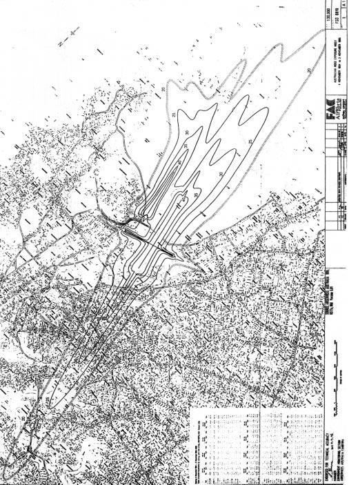
2 room with windows open (Sydney Draft Noise Management Plan, Volume 2, p. 6.13). It is also the level which equates with windows open to an indoor sound level of 60 db(a), the indoor design sound level which when heard inside a normal domestic living room by the average listener will not be judged as intrusive or annoying (Australian Standard AS ). It also equates, when the windows are closed, to an indoor level of about 45 to 50 db(a) which does not exceed the indoor design sound level considered acceptable for relaxing or sleeping areas (Australian Standard AS ). Results Single Track Analysis The 70 db(a)max noise level contour for each of the five representative types of aircraft is illustrated for each track in the discussion of the alternative operating modes (refer Chapter 4). It should be noted that the contour is a line joining points experiencing a maximum sound level of 70 db(a) and represents the outer edge of the exposure area. Points within the contours will experience noise greater than 70 db(a). Outside the 70 db(a) contour noise will still be heard since 70 db(a) is not the limit of audibility. The numbers of people falling within the 70 db(a)max contour for each track for the worst case (normally the B or B , or, for runway 34R, B767) are given in Figure 3 and Figure 4, which appear on the following two pages. 92 Long Term Operating Plan for Sydney Airport & Associated Airspace
3 Numbers of people within the 70dB(a) single event noise contour for aircraft at Sydney Airport Runway Operation Direction Mode People>=70dB(a) End suburb 07 Dep N Over water NE Over water E Over water S Over water W Over water NW Over water Arr All Royal Nat Pk 25 Dep N Belrose E Middle Harbour S Heathcote Nat Pk W Horsley Pk NW Toongabbie NW Parklea Arr All Over water 16L Dep N 5800 Over water E 5800 Over water S 5800 Over water S Over water W Over water NW Over water (B767) Arr ILS Hunters Hill (B767) Trident Waverton 16R Dep S 4000 Over water W 4000 Over water NW 4000 Over water N Over water E Over water S Over water W Heathcote Nat Pk NW Heathcote Nat Pk N Over water E Over water ILS Turramurra Trident Beecroft 34R (B767) Dep N Over water NE Over water E Over water S Over water (B767) Arr All 700 Over water 34L Dep N Ku-Ring-Gai Chase Nat Pk E Cromer S Royal Nat Pk W Horsley Pk NW Kellyville Arr All 700 Over water Figure 3 Long Term Operating Plan for Sydney Airport & Associated Airspace 93
4 Figure 4 Combined total of people within the 70dB(A) contour for each runway. Runway Operation People >=70dB(a) 07 Dep Arr Dep Arr L Dep 5800 (B767) Arr R Dep 4000 Arr R Mode 2 Dep L Dep Arr R (B767) Dep (B767) Arr 700 Notes for Figures 3 and 4: 1. Mode is noted only where a track is for a specific mode. 2. B747 aircraft do not depart from Runway 34R, therefore the number of people within the 70dB(A) contour for B767 aircraft is shown. 3. For Arrivals, All indicates arrivals from all directions are established on a straight approach before the beginning of the contour. ILS and Trident show whether the contour is straight down the ILS or down one arm of the Trident approach path. 4. Directions: N = North NE = North East, then North E = East W = West (Katoomba0 NW = North West (Richmond) NW1 (for Runway 25 Departures) = Immediate turn and track direct to Richmond from the runway end. 5. All numbers of people within the 70dB(A) contour are to the nearest People within the 70dB(A) contour are exposed to noise of EQUAL TO OR GREATER THAN 70dB(A) max. Single track analyses indicate that under the new operating arrangements the amount of traffic over most highly exposed residential areas will be much reduced, particularly in the parallel runway operations. However, a substantial number of people will experience aircraft noise greater than 70 db(a)max. 94 Long Term Operating Plan for Sydney Airport & Associated Airspace
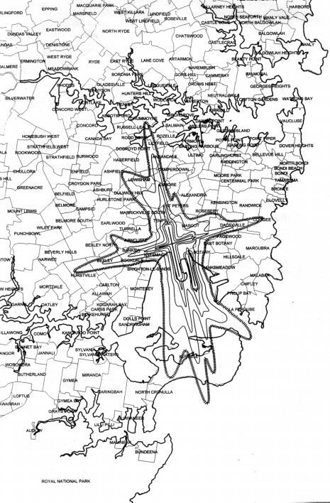
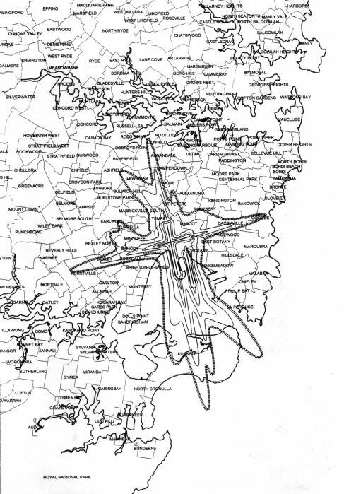
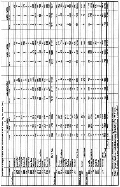
5 There is not much scope to spread arriving aircraft flight tracks, particularly close to the airport, but in sensitive areas some distribution of approach paths further out is possible. On the other hand, in relation to departures, a large number of alternative tracks have been developed and these are instrumental in achieving successful noise distribution. ANEC ANECs were produced for two scenarios using movement data from ANEC 1 was the first concept of the long term operating model for Sydney Airport and took into account a selection of modes in accordance with operational requirements and the need to achieve a balance in the distribution of noise between communities as well as a minimum environmental impact. ANEC 2 is a refinement of that model and represents an attempt by Airservices Australia to achieve a better balance in noise distribution. Further evaluation of the environmental impact of the operational arrangements assumed for ANEC 2 in terms of noise sharing is required. ANEC 1, and 2 are shown in figures 5 and 6 and the ANEI contours for 1993 and 1995 are shown in figures 7 and 8 respectively. However, in terms of the analysis of the ANEC itself, a comparison of the number of people within the 20, 25, and 30 ANEC contours with those in the same contours prior to the opening of the parallel runway (1993) and during full parallel runway operation (1995) shows that the very significant extension of the contour to the north and the corresponding contraction of the eastern and western arms as a consequence of the introduction of parallel runways (and supporting noise abatement procedures) in late 1994 would be largely reversed by the new operating arrangements. The numbers of people are broken down by Postcode (and representative suburb) and a comparison given in Figure 9. The population data is taken from the 1991 Census, the most current at the time. The estimated number of people within the respective contours for the 1993 Sydney ANEI is also shown for comparison. Figures 5 to 9 appear on the following five pages. Long Term Operating Plan for Sydney Airport & Associated Airspace 95
6
7

8
9
10
11 In 1995 about 50 per cent of aircraft operations were over northern suburbs. Under the proposed operating arrangements, the initial goal is for movements off runways to the north, east and west to be about 15 ±2%. Consistent with this, both ANEC 1 and ANEC 2 show a contraction of the northern contours in relation to those for the 1995 ANEI and an approximate equal distribution of contour areas to the north, east and west. The number of people within the 20, 25 and 30 ANEC contours is shown by Postcode Area in Table Figure 9. This table also shows that the number of people affected increases in the 20 ANEC contour but reduces significantly in the higher noise level contours. Thus, in 1995 there were some 10,960 people in the equal to or greater than 30 ANEI contour and 68,380 in the equal to or greater than 20 ANEI contour compared with 3940 and 116,860 respectively in ANEC2. This is very clear evidence that the noise impact in high noise areas has been dissipated and that there is now a much greater sharing of the noise burden. The ANEC analysis results also indicate that the total number of people exposed to noise greater than 20 ANEC under the ANEC 2 scenario, 116,860, is slightly less than under ANEC 1 scenario, 120,730. This is due mainly to slight increases in the percentage of movements for modes involving overwater operations factored into the model. However, both are significantly higher than the number of people exposed to this level of noise in 1995, some 68,380. This result is consistent with the sharing of noise impacts. However, it does show that the redirection to over water modes of even small percentages of movements produces worthwhile benefits. As the noise generated by arriving aircraft is concentrated into a long thin corridor while that from departing aircraft is spread into shorter broader bands, the effective spreading of noise relies mostly on the spread of departing traffic. The use of multiple departure tracks is a feature of the new operating design. The ANECs reflect this with the main arms of the contours directly attributable to arrivals and the broader spurs between the axes due to departure tracks. Suburbs to the north now clear of the 20 ANEC contour include those in Postcodes 2050 (e.g. Camperdown), 2047 (e.g. Drummoyne), 2110 (e.g. Hunters Hill), 2066 (e.g. Lane Cove), 2043 (e.g. Erskinville) and 2039 (e.g. Rozelle). Suburbs now within the 20 ANEC contour in ANEC 2 but not within this contour in the 1995 ANEI include those in Postcode 2203 (e.g. Dulwich Hill) and 2130 (e.g. Summer Hill) to the north; 2034 (e.g. Coogee), 2032 (e.g. Kingsford), 2035 (e.g. Maroubra) and 2031 (e.g. Randwick) to the east; and 2207 (e.g. Bexley), 2206 (e.g. Earlwood), 2222 (e.g. Penshurst) and 2220 (e.g. Hurstville) to the west. In moving from 1995 parallel operations to the new long term proposal, the suburbs that will show the biggest increase in the number of people exposed to aircraft noise greater than ANEC 20 will be those in the Postcodes mentioned above who were outside the 20 ANEI contour in 1995, as well as those in Long Term Operating Plan for Sydney Airport & Associated Airspace 101
12 Postcodes 2204 (Marrickville) 16,900 (previously 7420); 2018 (Eastlakes) 11,830 (previously 150); 2020 (Mascot) 7580 (previously 1320); 2205 (Arncliffe) 11,760 (previously 790); 2019 (Banksmeadow) 3380 (previously 1400) and 2216 (Rockdale) 10,010 (previously 430). ANEC analysis results indicate that the new flight path arrangements produce a contour pattern which is not dissimilar from that which applied in preparallel runway conditions but with some additional coverage of areas between the axes. They do so without losing the advantage of the extra capacity provided by the third runway. The use of full length departures for jet aircraft on runway 34L enables many aircraft to gain substantial height and to be able to turn while still close to the airport. This also produces some reduction in the noise at ground level and also facilitates the spreading of noise. To achieve maximum benefits, specific noise abatement departure procedures are necessary. Two alternative departure procedures have been standardised by ICAO. These are referred to as ICAO A and ICAO B. In both procedures, the departing aircraft is configured for a normal take-off pursuant to the aircraft weight and weather conditions. However, at an appropriate altitude, depending upon the procedure (1500 test for A ; 1000 feet for B ) the configuration of the aircraft is adjusted. This combines both power and flap changes which in turn affect the flight characteristics of the aircraft. Given that this issue was raised during the public consultative process it would be appropriate to refer it to the Implementation and Monitoring Committee managing community consultation during the implementation process. Noise Distribution and Monitoring As well as being a powerful prediction tool, the ANEF system can also be used for monitoring. In this case, Australian Noise Exposure Index (ANEI) contours can be produced from historical data. It is intended to prepare ANEI on a quarterly (and cumulative up to 12 months) basis following implementation of the long term operating plan and for the results to be used to guide subsequent operational practices. The Task Force considered a wide range of inputs and parameters that might be used to monitor the equidistribution of noise. The consensus view was that the system had to be simple, easily understood and accessible by the community. While at the same time there is a need to provide sufficient information for there to be community confidence in the monitoring process. To achieve this there has to be an agreed understanding of what is meant by fair and equitable. The task force environment working group was not able to identify a single criterion to demonstrate equity but it was able to identify a number of considerations which together, and in balance, could be considered to constitute the basis for a fair and reasonable distribution of noise. 102 Long Term Operating Plan for Sydney Airport & Associated Airspace
13 These were: Average Noise Exposure The average noise exposure levels for different community groups provide a basis for comparing their exposure levels. In this regard, the ANEF System is regarded as the best available and is directly referred to in the Australian Standard AS Noise Level and Duration of Exposure The type of aircraft, type of operation (arrival or departure) and height of overflight are all reflected in noise level. These may be considered collectively and put into a time of duration context as a Time Above noise metric such as T70, i.e. Time Above 70 db(a)max. Respite The concept of respite arises from a recognition of the need to provide quiet periods for those affected by noise and to balance these between communities, preferably with periods having no aircraft at all. Number of Overflights The number of each type of aircraft, both jets and propeller aircraft, is an important factor in considering disturbance levels. When associated with noise levels a noise metric such as N70 i.e. number of noise events above 70 db(a)max may be used. Time of the Day/Night Disturbance during or near sleeping hours outside curfew hours is a source of particular annoyance and should be minimised by use of over water operations and otherwise distributed. Non-reciprocal Flights A single population should not generally be subject to both arriving and departing traffic. Once the new airport operating and flightpath arrangements are in place it will be necessary to apply the above discussed noise sharing indices to assess the extent to which the noise is being shared. When applying the noise sharing assessment indices there will be apparent inconsistencies and it is very likely that what may appear to represent fair sharing using one of the indices may present a different picture when one of the other indices is applied. There is agreement that there be a system of determining noise levels at various locations throughout the metropolitan area to supplement operational data on runway use and modes and time of operation. Actual flight track data will be available from the NFPMS and it is intended that the INM be used on a periodic basis to calculate representative noise metrics (selected from the criteria mentioned above) at two circular arrays of points centred on the Long Term Operating Plan for Sydney Airport & Associated Airspace 103
14 airport. The points would be at, for example, 45 degree increments around the circle, and the radius of the two arrays could be 4 and 8 kilometres (or as otherwise decided). The period for calculation would be set at say quarterly or annual intervals. It is also proposed that this data be supplemented with appropriate graphical presentations, including track density plots which will show the level of air traffic activity over the inner areas of Sydney. A network of 12 permanent noise monitoring terminals is located around Sydney Airport. It is intended these be used to validate noise exposure data produced by other means. The location of these terminals will be reviewed to ensure they are appropriately placed. Portable monitors will also be employed on a short term basis at other locations where direct noise level data is required. Imbalances in noise distribution detected through the monitoring process are expected to be redressed in the subsequent quarter, subject only to prevailing weather conditions. In this regard, it is expected that the monitoring function will include and a review of runway usage in relation to runway availability. Reporting to the community on noise issues will occur through the general processes established for monitoring the overall plan. Runway selection procedures for noise sharing Set out below are the procedures for Runway selection Airservices Australia propose be introduced to maximise movements over water and distribute the remaining noise as equitably as possible between suburbs to the East, North East, North, North West, West and Southwest. These procedures will facilitate the optimum initialisation of the runway Modes to achieve the above objectives. The two fundamental factors which will influence the selection of runway for use outside the curfew period are forecast or prevailing weather and traffic levels including the balance between arrivals and departures. Following Task Force deliberations, Airservices Australia sought to provide a range of runway options which provided alternatives to achieve noise sharing and respite, suitable for use in varying weather and traffic conditions. The proposed utilisation of the 9 initial runway Modes is depicted in the pie chart at Figure 10 which gives the expected range of use of each Mode in the operating plan. The ANEC 2 contour on page xx is based on traffic levels falling within the range for the individual Modes depicted in the pie chart. For comparison purposes, Figure 11 depicts the actual utilisation of runway Modes during parallel runway operations in Long Term Operating Plan for Sydney Airport & Associated Airspace
15 Runway Movements (Estimated percentage of time a mode would be used) 64/73 Mode 7 25D/34A 15 20% 23 Mode 1 Curfew 4% Mode 4 Opp DIir 5 10% 64/73 Mode 14A 16D/07A 10 15% 73/80 Mode 10 16L/16R 20 25% Mode 5 16D/25A 10 15% Mode 12 & 13 Dedicated 07/25 2% Mode 9 34lls 25 30% Figure 10 Runway Movements (%) 1995 Actuals Mode 9 34lls 29% Mode 1 Curfew 4% Mode 12 & 13 Dedicated 07/25 2% Mode 10 16lls 65% Figure 11 To achieve the runway utilisation distribution depicted in the pie chart, it is proposed that a hierarchy of available runway combinations be used throughout each day. Diurnal variation and annual cyclical weather patterns will give some variation to the runway in use. At any time that weather conditions permit and traffic levels can be sustained Mode 4, or Runway 16L Departures/Runway 34 L Arrivals, will be the nominated runway. Long Term Operating Plan for Sydney Airport & Associated Airspace 105
16 For any period, be it a day or part thereof, either a northerly or a southerly weather pattern will be evident. The runway options available in a southerly direction are Runway 16L&R for departures with arrivals on either Runways 07, 25 or 16L&16R. Options available in a northerly direction are Runways 34L&R or Runway 25 with arrivals on Runways 34L&R It is proposed that the current bias towards operations in a southerly direction be removed and that runways be selected on the basis of a prevailing headwind component except where the runway for use is Mode 4, Runway 16L departures and Runway 34L for arrivals. Whilst this is proposed as the criterion for runway selection, the 5 knot tailwind tolerance should be retained to enable a smooth, well managed transition from a runway combination already in use. The anticipation and planning of a runway change is critical for the maintenance of a safe and efficient airways system. As the tailwind component on a runway increases, the suitability of that runway may become marginal, leading to aircraft crews specifying the need for a more in-to-wind runway, This is particularly the case for Runways 07/25 and 16L/34R, because of the length available, and this need will vary with aircraft weight and ambient temperature. Runway Selection Proposal It is proposed Mode 4 be the preferred Mode during all non-curfew hours subject to weather and traffic. A change of runway will be triggered by one or a combination of three factors. These are weather, anticipated traffic demand or delay and provision of respite. Changes due to weather cannot be influenced but they can be effectively managed to ensure a smooth transition from one runway mode to another. Traffic capacities established through Sabre modelling and operational experience will determine whether a runway configuration can handle the traffic offering. Programmed traffic, through airline schedules and aircraft flight plans, allows an assessment of anticipated aircraft delays. to be made in sufficient time to allow a managed runway change to take place. In line with recent practice, respite triggers should also occur during the day which provide a decision point for a change to an available runway combination, subject to weather and traffic capacities, which, where possible, provides relief to areas which have been bearing the noise burden over the previous period. On weekdays in the period 0600 to 0730 when Mode 4 cannot be used, a crossrunway Mode should be used (Modes 5, 7 or 14A). The chosen Mode should be the Mode that facilitates the change to parallel operations at a capacity trigger point occurring around 0700 and Long Term Operating Plan for Sydney Airport & Associated Airspace
17 Analysis of busy hour statistics indicates that on a majority of weekdays between 0730 and 0900 there is at least one half hour period when the number of arrivals exceed 20. This means a single arrival runway would not be able to maintain the efficiency of operation and according parallel runway would be required (noting, however that there may be occasions when in the Runway 34 direction that the shift from 25/34 operation could be delayed because of the greater arrival capacity with this Mode). Accordingly, it is proposed that on weekdays during the period from around 0730 to 1030 (or later if traffic requires) Modes 9 or 10 be the preferred Modes. Following this period an assessment will be made on the availability of an alternate runway configuration. This will occur around 1030, with some flexibility either side to meet a suitable point in the traffic sequence. The configuration chosen should, where possible, be an alternate to the configuration in use during the previous period. A further respite trigger will occur at around 1600 and again at 2000 and an alternate to the runway combination in use will be sought where weather and traffic conditions permit. The afternoon weekday peak periods are not as pronounced or as regular as the morning peaks and accordingly it is not proposed to give Mode 9 and 10 preference during these periods. However, there will frequently be a requirement to use these Modes during the afternoon peaks and it is anticipated that a weather or traffic trigger will be used to bring these Modes into operation. Runway changes for traffic reasons will be predicated on an anticipated arrival delay which exceeds 10 minutes and which is expected to remain at that level or increase during the period. This trigger is only likely to activate where the mode of operation only gives a single arrival runway (Modes 4, 5, 14A). Runway changes brought about by departure delays will not occur until departure delays, not including normal pushback and taxiing times, will exceed 10 minutes and are expected to remain at or above that level for 30 minutes. This trigger is only likely to activate where a single departure runway is nominated (Mode 4, 7). The following matrix shows runway options and an hierarchy for selection throughout the day. Where there is equal preference for a number of runway configurations, the selection, where possible will be an alternate to the configuration in use during the previous period. Parallel runway options, although further down the order of preference, will receive exposure through weather or capacity driven imperatives. Long Term Operating Plan for Sydney Airport & Associated Airspace 107
18 FIRST SECOND THIRD FOURTH 2300 to 0600 Departures 16R N/A N/A N/A (Curfew) Arrivals 34L Departures 16L 1. Departures 16L&R 34 Parallels 07 only Arrivals 34L Arrivals Parallels 25 only 2. Departures 16L&R Arrivals Departures 25 Arrivals 34L&R Departures 16L 34 Parallels 07 only N/A Arrivals 34L 16 Parallels 25 only N/A Departures 16L 1. Departures 16L&R 34 Parallels 07 only Arrivals 34L Arrivals Parallels 25 only 2. Departures 25 Arrivals 34L&R 3. Departures 16L&R Arrivals Departures 16L 1. Departures Parallels 07 only Arrivals 34L Arrivals 34L&R 16 Parallels 25 only 2. Departures 16L&R Arrivals Departures 16L&R Arrivals * Departures 16L 1. Departures 16L&R 34 Parallels 07 only Arrivals 34L Arrivals Parallels 25 only 2. Departures 16L&R Arrivals Departures 25 Arrivals 34 L&R Note: Preference depends on wind, weather and traffic demands. * Curfew legislation requires departures after 2245 to use Runway 16L or 16R. The matrix applicable on weekends deletes the period 0730 to 1030 where parallel operations are specified during the week. However, similar to afternoon peak periods mid-week, there will be times when parallel operations will need to be employed, brought on by weather or traffic triggers, particularly Sunday afternoons and/or evenings. 108 Long Term Operating Plan for Sydney Airport & Associated Airspace
19 FIRST SECOND THIRD FOURTH 2300 to 0600 Departures 16R N/A N/A N/A (Curfew) Arrivals 34L Departures 16L 1. Departures 16L & R 34 Parallels 07 only Arrivals 34L Arrivals Parallels 25 only 2. Departures 16L & R Arrivals Departures 25 Arrivals 34L & R Departures 16L 1. Departures 16L & R 34 Parallels 07 only Arrivals 34L Arrivals Parallels 25 only 2. Departures 25 Arrivals 34L & R 3. Departures 16L & R Arrivals Departures 16L 1. Departures 16L & R 34 Parallels 07 only Arrivals 34L Arrivals 34L & R 16 Parallels 25 only 2. Departures 16L & R Arrivals Departures 16L & R Arrivals * Departures 16L 1. Departures 16L & R 34 Parallels 07 only Arrivals 34L Arrivals Parallels 25 only 2. Departures 16L & R Arrivals Departures 25 Arrivals 34 L & R Note: Preference depends onwind, weather and traffic demands * Curfew legislation requires departures after 2245 to use Runway 16L or 16R. The monitoring arrangements proposed in Chapter 7 are designed to achieve an equitable distribution of impacts as between eastern, northern and western residential areas affected by aircraft noise. The ANEC 2 contour described in Chapter 5 is one measure of equity based on noise distribution. Other factors that need to be taken into account are the number of flights over particular areas and the hours that individual areas will be subjected to aircraft overflights. Long Term Operating Plan for Sydney Airport & Associated Airspace 109
20 Figures 12 and 13 provide an indication of the potential hours that suburbs to the east, north and west will experience aircraft noise with the same level of traffic assumed in the ANEC 2 contour. Also figure 13 indicates that using Sabre capacity figures the cross runway modes have the potential to be available for substantial periods of time to permit equitable sharing of noise, even if Sydney Airport reaches 360,000 movements per annum. Sydney Airport 270,000 Movements a Year (Based on a 17-hour day excluding curfew period) Mode Percentage Total yearly Avg mov Hrs per year Hours North East West ***Runway of movements movement rate per hr 17 hr. day hours hours hours %17hrs availability Mode Modes Mode Mode Mode *Mode *Mode 14A *Mode Total ** * There will be some movements of long haul aircraft over the north during operation of these modes. ** Average hourly movement rate for a 17-hour day *** Percentage availability of mode based on Bureau of Meteorology wind study covering 55 years (1940 to 1995), with maximum downwind component of 5 knots and maximum crosswind of 25 knots. Figure Long Term Operating Plan for Sydney Airport & Associated Airspace
21 Sydney Airport 360,000 Movements a Year (Based on a 17-hour day excluding curfew period) Long Term Operating Plan for Sydney Airport & Associated Airspace 111 Figure 13 Mode Percentage Total yearly Avg mov Hrs per year Hours North East West ***Runway of movements movement rate per hr 17 hr. day hours hours hours %17hrs availability Mode Modes Mode Mode Mode *Mode *Mode 14A *Mode Total ** * There will be some movements of long haul aircraft over the north during operation of these modes. ** Average hourly movement rate for a 17-hour day *** Percentage availability of mode based on Bureau of Meteorology wind study covering 55 years (1940 to 1995), with maximum downwind component of 5 knots and maximum crosswind of 25 knots.
airservice';1 Sydney Airport Operational Statistics July 2018
 airservice'; Sydney Airport Operational Statistics July 8 i PREVEW Sydney Airport Operational Statistics Report Preview July 8 Total Runway Movements (excluding helicopter operations) (refer pages 6-)
airservice!'1 Sydney Airport Operational Statistics January 2018
 airservice!' Sydney Airport Operational Statistics January 8 i PREVEW Sydney Airport Operational Statistics Report Preview January 8 Total Runway Movements (excluding helicopter operations) (refer pages
airservice';1 Sydney Airport Operational Statistics March 2018
 airservice'; Sydney Airport Operational Statistics March 8 i PREVEW Sydney Airport Operational Statistics Report Preview March 8 Total Runway Movements (excluding helicopter operations) (refer pages 6-)
REVIEW OF GOLD COAST AIRPORT Noise Abatement Procedures
 REVIEW OF GOLD COAST AIRPORT Noise Abatement Procedures Introduction The purpose of this document is to present an overview of the findings of the review of the Noise Abatement Procedures (NAPs) in place
Perth Noise Abatement Procedures - Change to Preferred Runways
 Environmental Analysis Summary Preferred Runways Perth Perth Airport Perth Noise Abatement Procedures - Change to Preferred Runways Environmental Analysis Summary April 2016 1 of 10 Environment Analysis
REVIEW OF PERTH AIRPORT Noise Abatement Procedures
 REVIEW OF PERTH AIRPORT Noise Abatement Procedures Contents SUMMARY... 3 Summary of Review Findings... 3 BACKGROUND... 4 Noise Abatement Procedures... 4 Perth Airport Noise Abatement Procedures... 4 Noise
Departures over the north-west, west and south-west from Runway 25. Arrivals from the south on Runways 34L and 34R.
 Mode 7 Method of operation Departures over the north-west, west and south-west from Runway 25. Arrivals from the south on Runways 34L and 34R. Departures over the north and northwest from Runway 34L for
Short Term Monitoring Program NSW, Caringbah Report. February 2013
 NSW, Caringbah Report February 2013 Version Control Version Number Date Detail 1.0 February 2013 Initial Release. 2.0 May 2013 Updated formatting for table 2. 3.0 January 2014 Figure 5 and L90 values updated
NOISE AND FLIGHT PATH MONITORING SYSTEM BRISBANE QUARTERLY REPORT JULY - SEPTEMBER 2011
 NOISE AND FLIGHT PATH MONITORING SYSTEM BRISBANE QUARTERLY REPORT JULY - SEPTEMBER 211 Date Version Comments Page 2 Foreword Airservices Australia has established a Noise and Flight Path Monitoring System
NOISE AND FLIGHT PATH MONITORING SYSTEM BRISBANE QUARTERLY REPORT OCTOBER - DECEMBER 2013
 NOISE AND FLIGHT PATH MONITORING SYSTEM BRISBANE QUARTERLY REPORT OCTOBER - DECEMBER 213 Date Version Comments Page 2 Foreword Airservices Australia has established a Noise and Flight Path Monitoring System
Review of brisbane Airport Noise Abatement Procedures
 Review of brisbane Airport Noise Abatement Procedures 1. Summary This document presents an overview of the findings of the review of the Noise Abatement Procedures in place for Brisbane Airport. The technical
AIRCRAFT NOISE INFORMATION PACK: CANNING VALE
 AIRCRAFT NOISE INFORMATION PACK: Table of Contents CANNING VALE 1. Aircraft movements affecting Canning Vale... 2 2. Effects of wind on runway selection... 2 3. Seasonal winds... 2 4. Flight path illustrations...
Short Term Monitoring Program NSW, Carlingford Report. February 2013
 NSW, Carlingford Report February 2013 Version Control Version Number Date Detail 1.0 February 2013 Initial Release. 2.0 May 2013 Updated formatting for table 2. 3.0 January 2014 Figure 5 and L90 values
Perth Airport. Runway 21 Night-Time Departure Trial Proposal. Environmental Analysis Summary. August Airservices Australia 1 of 17
 Perth Airport Runway 21 Night-Time Departure Trial Proposal Environmental Analysis Summary August 2015 Airservices Australia 1 of 17 Change Summary Version Date Change Description Amended by 1 6 August
AIRSERVICES AUSTRALI A
 AIRSERVICES AUSTRALI A NOISE AND FLIGHT PATH MONITORING SYSTEM BRISBANE QUARTERLY REPORT JANUARY - MARCH 211 Page 2 Foreword Airservices Australia has established a Noise and Flight Path Monitoring System
NOISE AND FLIGHT PATH MONITORING SYSTEM MELBOURNE QUARTERLY REPORT JULY - SEPTEMBER 2011
 NOISE AND FLIGHT PATH MONITORING SYSTEM MELBOURNE QUARTERLY REPORT JULY - SEPTEMBER 211 Date Version Comments Page 2 Foreword Airservices Australia has established a Noise and Flight Path Monitoring System
NOISE AND FLIGHT PATH MONITORING SYSTEM MELBOURNE QUARTERLY REPORT OCTOBER - DECEMBER 2012
 NOISE AND FLIGHT PATH MONITORING SYSTEM MELBOURNE QUARTERLY REPORT OCTOBER - DECEMBER 212 Date Version Comments Page 2 Foreword Airservices Australia has established a Noise and Flight Path Monitoring
Appendix B Ultimate Airport Capacity and Delay Simulation Modeling Analysis
 Appendix B ULTIMATE AIRPORT CAPACITY & DELAY SIMULATION MODELING ANALYSIS B TABLE OF CONTENTS EXHIBITS TABLES B.1 Introduction... 1 B.2 Simulation Modeling Assumption and Methodology... 4 B.2.1 Runway
NOISE AND FLIGHT PATH MONITORING SYSTEM MELBOURNE QUARTERLY REPORT JULY - SEPTEMBER 2013
 NOISE AND FLIGHT PATH MONITORING SYSTEM MELBOURNE QUARTERLY REPORT JULY - SEPTEMBER 213 Date Version Comments Page 2 Foreword Airservices Australia has established a Noise and Flight Path Monitoring System
AIRSERVICES AUSTRALI A
 AIRSERVICES AUSTRALI A NOISE AND FLIGHT PATH MONITORING SYSTEM BRISBANE QUARTERLY REPORT APRIL - JUNE 211 Date Version Comments Page 2 Foreword Airservices Australia has established a Noise and Flight
Short Term Monitoring Program Tarragindi Report, QLD
 Short Term Monitoring Program Change Summary Version 1: 30 Aug 2013 Section/ Clause Summary NRFC Table of Contents 1. Deployment Details...3 1.1 Deployment Purpose...3 1.2 Deployment Monitoring Period...3
Canberra Noise Information Pack December 2011
 Canberra Noise Information Pack December 2011 Table of Contents Purpose 2 Overview 2 Canberra Airport 3 Hours of Operation/Noise Abatement Areas 3 Runway Configuration 3 Air Traffic 3 Track density plot
Perth Airport Aircraft Noise Validation Study Terms of Reference
 Perth Airport Aircraft Noise Validation Study Terms of Reference Change Summary Version 1: 6 April 2016 Section/ Clause Summary New Document 06/04/2016 Table of Contents 1. Purpose...3 2. Background...
5 Rail demand in Western Sydney
 5 Rail demand in Western Sydney About this chapter To better understand where new or enhanced rail services are needed, this chapter presents an overview of the existing and future demand on the rail network
Environmental Assessment. Runway 14 Smart Tracking Approach Gold Coast Airport
 Environmental Assessment Runway 14 Smart Tracking Approach Gold Coast Airport Table of Contents Introduction ` 3 Runway 14 Smart Tracking approach 3 Assessment 3 Assumptions 3 Nominated aircraft 3 How
GOLD COAST AIRPORT - Runway 14 southern departures trial
 Post Implementation Review GOLD COAST AIRPORT - Runway 14 southern departures trial Version 1 Effective January 2016 Airservices Australia 2016 1 of 13 Introduction At the request of the community, Airservices
Gold Coast Airport Aircraft Noise Information Report
 Gold Coast Airport Aircraft Noise Information Report Quarter 3 2012 (July to September) 1 Version Control Version Number Detail Prepared by Date 1 - Environment 2 November 2012 2 Updated Figure 10 Environment
Canberra International Airport
 Canberra International Airport Innovative Land Use Planning at Canberra International Airport, Australian Capital Territory (ACT), Australia 7 March 2006 1 City Centre Northerly arr and dep Federal Parliament
> Aircraft Noise. Bankstown Airport Master Plan 2004/05 > 96
 Bankstown Airport Master Plan 2004/05 > 96 24.1 Why Is Aircraft Noise Modelled? Modelling of the noise impact of aircraft operations has been undertaken as part of this MP. Such modelling is undertaken
Changing runways at Sydney Airport to share the noise
 Changing runways at Sydney Airport to share the noise The purpose of this document is to show the variables and challenges that Sydney air traffic controllers face when deciding to use different runway
Gold Coast Airport Aircraft Noise Information Report
 Gold Coast Airport Aircraft Noise Information Report Quarter 2 2014 (April to June) 1 Version Control Version Number Detail Prepared by Date 1 - Environment September 2014 Airservices Australia. All rights
Aircraft Noise. Why Aircraft Noise Calculations? Aircraft Noise. SoundPLAN s Aircraft Noise Module
 Aircraft Noise Why Aircraft Noise Calculations? Aircraft Noise Aircraft noise can be measured and simulated with specialized software like SoundPLAN. Noise monitoring and measurement can only measure the
SAMTRANS TITLE VI STANDARDS AND POLICIES
 SAMTRANS TITLE VI STANDARDS AND POLICIES Adopted March 13, 2013 Federal Title VI requirements of the Civil Rights Act of 1964 were recently updated by the Federal Transit Administration (FTA) and now require
Cairns Noise Information Pack. December 2011
 Cairns Noise Information Pack December 2011 Table of Contents Purpose 2 Overview 2 Cairns Airport 3 Hours of Operation 3 Runway Configuration 3 Air Traffic 3 Track Density Plot for all aircraft operations
Gold Coast Noise Information pack June 2012
 Gold Coast Noise Information pack June 2012 Table of Contents Purpose 2 Overview 2 Hours of Operation/Curfews 3 Runway Configuration 3 Air Traffic 4 Track Density Plot 4 Typical tracks for Wind Conditions
Noise Action Plan Summary
 2013-2018 Noise Action Plan Summary Introduction The EU Noise Directive 2002/49/EU and Environmental Noise (Scotland) Regulations 2006 requires airports with over 50,000 movements a year to produce a noise
Environment and Climate Change Unit
 Environmental Assessment of Interim Procedure Alternative to KEELS SID Runway 03 Perth Airport October 2010 ARMS 208275 DISCLAIMER This report contains a summary of data collected from external and internal
Canberra Airport Aircraft Noise Information Report
 Canberra Airport Aircraft Noise Information Report Quarter 1 2016 (January to March) 1 Version Control Version Number Detail Prepared by Date 1 - Environment June 2016 Airservices Australia. All rights
NOISE ABATEMENT PROCEDURES
 1. Introduction NOISE ABATEMENT PROCEDURES Many airports today impose restrictions on aircraft movements. These include: Curfew time Maximum permitted noise levels Noise surcharges Engine run up restrictions
Christchurch PBN Flight Paths Trial. Interim Report
 Christchurch PBN Flight Paths Trial Interim Report Christchurch PBN Flight Paths Trial Interim Report PBN trial partners have prepared the following summary outlining progress of the PBN flight paths trial.
STAFF REPORT. Airport Land Use Plan Consistency Review: Old Town Village Mixed Use Project City of Goleta. MEETING DATE: June 18, 2015 AGENDA ITEM: 5M
 STAFF REPORT SUBJECT: Airport Land Use Plan Consistency Review: Old Town Village Mixed Use Project City of Goleta MEETING DATE: AGENDA ITEM: 5M STAFF CONTACT: Peter Imhof, Andrew Orfila RECOMMENDATION:
Short Term Monitoring Program South Dingley Village, VIC
 Short Term Monitoring Program Version Control Page Summary Version 2: 11 May 2015 4 and 5 Update of dot point 8 (page 4) regarding contribution of community noise on captured events. Deletion of Table
Washington Dulles International Airport (IAD) Aircraft Noise Contour Map Update
 Aircraft Noise Contour Map Update") Washington Dulles International Airport (IAD) Aircraft Noise Contour Map Update Ultimate ASV, Runway Use and Flight Tracks 4th Working Group Briefing 8/13/18 Meeting Purpose Discuss Public Workshop input
Washington Dulles International Airport (IAD) Aircraft Noise Contour Map Update Ultimate ASV, Runway Use and Flight Tracks 4th Working Group Briefing 8/13/18 Meeting Purpose Discuss Public Workshop input
Runway 35 South & West (Jet) Departure Flight Path Amendment
 Departure Flight Path Amendment") Environmental Assessment Runway 35 South & West (Jet) Departure Flight Path Amendment Canberra Airport Airservices Australia 1 of 8 Environment Assessment Runway 35 South & West (Jet) Departure & North
Environmental Assessment Runway 35 South & West (Jet) Departure Flight Path Amendment Canberra Airport Airservices Australia 1 of 8 Environment Assessment Runway 35 South & West (Jet) Departure & North
Draft Concept Alternatives Analysis for the Inaugural Airport Program September 2005
 Draft Concept Alternatives Analysis for the Inaugural Airport Program September 2005 Section 3 - Refinement of the Ultimate Airfield Concept Using the Base Concept identified in Section 2, IDOT re-examined
STAFF REPORT. Airport Land Use Plan Consistency Review: Santa Barbara Airport Master Plan. MEETING DATE: November 19, 2015 AGENDA ITEM: 7D
 STAFF REPORT SUBJECT: Airport Land Use Plan Consistency Review: Santa Barbara Airport Master Plan MEETING DATE: AGENDA ITEM: 7D STAFF CONTACT: Peter Imhof, Andrew Orfila RECOMMENDATION: Adopt findings
STAFF REPORT. Airport Land Use Consistency Determination Betteravia Plaza. MEETING DATE: January 21, 2016 AGENDA ITEM: 8D
 STAFF REPORT SUBJECT: Airport Land Use Consistency Determination Betteravia Plaza MEETING DATE: AGENDA ITEM: 8D STAFF CONTACT: Andrew Orfila RECOMMENDATION: Adopt findings for the Betteravia Plaza project
According to FAA Advisory Circular 150/5060-5, Airport Capacity and Delay, the elements that affect airfield capacity include:
 4.1 INTRODUCTION The previous chapters have described the existing facilities and provided planning guidelines as well as a forecast of demand for aviation activity at North Perry Airport. The demand/capacity
Cairns Airport Aircraft Noise Information Report
 Cairns Airport Aircraft Noise Information Report Quarter 4 2015 (October to December) 1 Version Control Version Number Detail Prepared by Date 1 - Environment February 2016 Airservices Australia. All rights
Consideration will be given to other methods of compliance which may be presented to the Authority.
 Advisory Circular AC 139-10 Revision 1 Control of Obstacles 27 April 2007 General Civil Aviation Authority advisory circulars (AC) contain information about standards, practices and procedures that the
Recommendations for Northbound Aircraft Departure Concerns over South Minneapolis
 Recommendations for Northbound Aircraft Departure Concerns over South Minneapolis March 21, 2012 Noise Oversight Committee Agenda Item #4 Minneapolis Council Member John Quincy Background Summer of 2011
Martin County Airport / Witham Field Noise Abatement Departure Profile (NADP) Demonstration Technical Report March 2010
 Demonstration Technical Report March 2010") Martin County Airport / Witham Field Noise Abatement Departure Profile (NADP) Demonstration Technical Report March 2010 Prepared for: Federal Aviation Administration (FAA) Orlando Airport District Office
Martin County Airport / Witham Field Noise Abatement Departure Profile (NADP) Demonstration Technical Report March 2010 Prepared for: Federal Aviation Administration (FAA) Orlando Airport District Office
Classification: Public AIRSPACE AND FUTURE OPERATIONS CONSULTATION (JANUARY-MARCH 2019)
") AIRSPACE AND FUTURE OPERATIONS CONSULTATION (JANUARY-MARCH 2019) LOCAL AUTHORITY BRIEFING 8 FEBRUARY 2019 Westerly operations Easterly operations PRESENTATION OVERVIEW Intro Airspace and Future Operations
AIRSPACE AND FUTURE OPERATIONS CONSULTATION (JANUARY-MARCH 2019) LOCAL AUTHORITY BRIEFING 8 FEBRUARY 2019 Westerly operations Easterly operations PRESENTATION OVERVIEW Intro Airspace and Future Operations
The purpose of this Demand/Capacity. The airfield configuration for SPG. Methods for determining airport AIRPORT DEMAND CAPACITY. Runway Configuration
 Chapter 4 Page 65 AIRPORT DEMAND CAPACITY The purpose of this Demand/Capacity Analysis is to examine the capability of the Albert Whitted Airport (SPG) to meet the needs of its users. In doing so, this
Environment Assessment of Darwin Airport Traffic Management Plan Effective December 2014
 Environment Assessment of Darwin Airport Traffic Management Plan Effective December 2014 Uncontrolled if printed Airservices Australia 2014 1 of 11 Table of contents 1 Introduction...3 1.1 Darwin Airport
Opportunities to improve noise management and communications at Heathrow
 Opportunities to improve noise management and communications at Heathrow Summary of a dialogue between Aviation Environment Federation, British Airways, HACAN, Heathrow Airport and NATS 1. Introduction
Short Term Monitoring Program Parkdale, VIC
 Short Term Monitoring Program Version Control Page Summary Version 2: 11 May 2015 4 and 5 All data regarding CNE decreased by one, due to identified highest CNE in V1 being confirmed as a community noise
1. Purpose and scope. a) the necessity to limit flight duty periods with the aim of preventing both kinds of fatigue;
 the necessity to limit flight duty periods with the aim of preventing both kinds of fatigue;") ATTACHMENT A. GUIDANCE MATERIAL FOR DEVELOPMENT OF PRESCRIPTIVE FATIGUE MANAGEMENT REGULATIONS Supplementary to Chapter 4, 4.2.10.2, Chapter 9, 9.6 and Chapter 12, 12.5 1. Purpose and scope 1.1 Flight
ATTACHMENT A. GUIDANCE MATERIAL FOR DEVELOPMENT OF PRESCRIPTIVE FATIGUE MANAGEMENT REGULATIONS Supplementary to Chapter 4, 4.2.10.2, Chapter 9, 9.6 and Chapter 12, 12.5 1. Purpose and scope 1.1 Flight
STUDY OF RUNWAY 12L AND 12R ARRIVAL OPERATIONS. September 2016
 STUDY OF RUNWAY 12L AND 12R ARRIVAL OPERATIONS September 2016 Environment Department, Noise Program Office Metropolitan Airports Commission 6040 28th Avenue South, Minneapolis, MN 55450 MetroAirports.org
Dublin Airport - Noise Management Plan
 Dublin Airport - Noise Management Plan May 2018 Issue: Final Prepared By: daa Reviewed By: Noise Strategy Working Group 15/5/2017 Authorised By: Group Head Asset Care 22/05/2018 Contents Abbreviations...
Measuring, Managing and Mitigating Aircraft Related Noise
 Measuring, Managing and Mitigating Aircraft Related Noise Airport noise is, understandably, a significant issue for some of our neighbouring communities. Achieving the most appropriate balance between
Canberra Airport Aircraft Noise Information Report
 Canberra Airport Aircraft Noise Information Report Quarter 3 2012 (July to September) 1 Version Control Version Number Detail Prepared by Date 1 - Environment 5 December 2012 2 - Environment 13 December
Technical Report. Aircraft Overflight and Noise Analysis. Brisbane, California. December Prepared by:
 Aircraft Noise Abatement Office Technical Report Aircraft Overflight and Noise Analysis Brisbane, California Prepared by: P.O. Box 8097 San Francisco, California 94128 (650) 821-5100 Introduction In response
Executive Summary. MASTER PLAN UPDATE Fort Collins-Loveland Municipal Airport
 Executive Summary MASTER PLAN UPDATE Fort Collins-Loveland Municipal Airport As a general aviation and commercial service airport, Fort Collins- Loveland Municipal Airport serves as an important niche
ENVIRONMENT ACTION PLAN
 ENVIRONMENT ACTION PLAN 2015 16 Airservices Australia 2015 This work is copyright. Apart from any use as permitted under the Copyright Act 1968, no part may be reproduced by any process without prior written
Cairns Airport Aircraft Noise Information Report. Quarter (July to September)
") Cairns Airport Aircraft Noise Information Report Quarter 3 2012 (July to September) 1 Version Control Version Number Detail Prepared by Date 1 - Environment 19 December 2012 Airservices Australia. All
Cairns Airport Aircraft Noise Information Report Quarter 3 2012 (July to September) 1 Version Control Version Number Detail Prepared by Date 1 - Environment 19 December 2012 Airservices Australia. All
Canberra Airport Aircraft Noise Information Report
 Canberra Airport Aircraft Noise Information Report Quarter 4 2015 (October to December) 1 Version Control Version Number Detail Prepared by Date 1 - Environment March 2016 Airservices Australia. All rights
TANZANIA CIVIL AVIATION AUTHORITY AIR NAVIGATION SERVICES INSPECTORATE. Title: CONSTRUCTION OF VISUAL AND INSTRUMENT FLIGHT PROCEDURES
 Page 1 of 8 1. PURPOSE 1.1. This Advisory Circular provides guidance to personnel involved in construction of instrument and visual flight procedures for publication in the Aeronautical Information Publication.
Gold Coast Airport. Aircraft Noise Information Report. Quarter (July to September) Page 1
 Page 1") Gold Coast Airport Aircraft Noise Information Report Quarter 3 2013 (July to September) Page 1 Version Control Version Number Detail Prepared by Date 1 - Environment 16 December 2013 2 Update to text on
Gold Coast Airport Aircraft Noise Information Report Quarter 3 2013 (July to September) Page 1 Version Control Version Number Detail Prepared by Date 1 - Environment 16 December 2013 2 Update to text on
Gold Coast Airport Aircraft Noise Information Report
 Gold Coast Airport Aircraft Noise Information Report Quarter 1 2016 (January to March) 1 Version Control Version Number Detail Prepared by Date 1 - Environment May 2016 Airservices Australia. All rights
St. Paul Downtown Airport (STP)
") Reliever Airports: NOISE ABATEMENT PLAN St. Paul Downtown Airport (STP) 1 INTRODUCTION The noise abatement plan for the St. Paul Downtown Airport (STP) was prepared in recognition of the need to make the
Reliever Airports: NOISE ABATEMENT PLAN St. Paul Downtown Airport (STP) 1 INTRODUCTION The noise abatement plan for the St. Paul Downtown Airport (STP) was prepared in recognition of the need to make the
SOUTH CAMBRIDGESHIRE DISTRICT COUNCIL. Executive Director / Senior Planning Policy Officer
 SOUTH CAMBRIDGESHIRE DISTRICT COUNCIL REPORT TO: Leader and Cabinet 8 May 2008 AUTHOR/S: Executive Director / Senior Planning Policy Officer SOUTH CAMBRIDGESHIRE DISTRICT COUNCIL S RESPONSE TO UTTLESFORD
Analysis of Operational Impacts of Continuous Descent Arrivals (CDA) using runwaysimulator
 using runwaysimulator") Analysis of Operational Impacts of Continuous Descent Arrivals (CDA) using runwaysimulator Camille Shiotsuki Dr. Gene C. Lin Ed Hahn December 5, 2007 Outline Background Objective and Scope Study Approach
Analysis of Operational Impacts of Continuous Descent Arrivals (CDA) using runwaysimulator Camille Shiotsuki Dr. Gene C. Lin Ed Hahn December 5, 2007 Outline Background Objective and Scope Study Approach
SUBMISSION BY THE BOARD OF AIRLINE REPRESENTATIVES OF NEW ZEALAND ON THE DRAFT QUEENSTOWN LAKES DISTRICT COUNCIL DRAFT PLAN
 SUBMISSION BY THE BOARD OF AIRLINE REPRESENTATIVES OF NEW ZEALAND ON THE DRAFT QUEENSTOWN LAKES DISTRICT COUNCIL DRAFT PLAN Background to BARNZ BARNZ is an incorporated society comprising 19 member airlines
Sunshine Coast and Caloundra Airports Aircraft Noise Information Report
 Sunshine Coast and Caloundra Airports Aircraft Noise Information Report Quarter 3 2015 (July to September) 1 Version Control Version Number Detail Prepared by Date 1 - Environment December 2015 Airservices
POST-IMPLEMENTATION COMMUNITY IMPACT REVIEW
 POST-IMPLEMENTATION COMMUNITY IMPACT REVIEW RNAV STAR updates and RNP AR approaches at Halifax Stanfield International Airport NAV CANADA 77 Metcalfe Street Ottawa, Ontario K1P 5L6 November 2017 The information
Pacifica. Short Term Aircraft Noise Monitoring
 Short Term Aircraft Noise Monitoring March March, Pacifica Prepared for the Oddstad Boulevard Park Pacifica Avenue Neighborhoods by San Francisco International Airport Noise Abatement Office P.O. Box 8097
FUTURE AIRSPACE CHANGE
 HEATHROW EXPANSION FUTURE AIRSPACE CHANGE UPDATE SEPTEMBER 2018 On 25 June 2018, Parliament formally backed Heathrow expansion, with MPs voting in support of the Government s Airports National Policy Statement
Guidance for Complexity and Density Considerations - in the New Zealand Flight Information Region (NZZC FIR)
") Guidance for Complexity and Density Considerations - in the New Zealand Flight Information Region (NZZC FIR) Version 1.0 Director NSS 14 February 2018 Guidance for Complexity and Density Considerations
Guidance for Complexity and Density Considerations - in the New Zealand Flight Information Region (NZZC FIR) Version 1.0 Director NSS 14 February 2018 Guidance for Complexity and Density Considerations
POST-IMPLEMENTATION COMMUNITY IMPACT REVIEW
 POST-IMPLEMENTATION COMMUNITY IMPACT REVIEW RNAV STAR updates and RNP AR approaches at Winnipeg James Armstrong Richardson International Airport NAV CANADA 77 Metcalfe Street Ottawa, Ontario K1P 5L6 November
Badgery s Creek Airport Presention. Revised from NAN 2015 AGM
 Badgery s Creek Airport Presention Revised from NAN 2015 AGM Contents History Badgery s Creek Objectives Why is another airport required? Badgery s Creek Airport key facts, approval process and timeline
Airport Noise Modelling ACNCC Meeting October 15, 2009
 ACNCC Meeting October 15, 2009 Prepared by: AECOM Canada Ltd. 2540 Kensington Road NW, Calgary, AB, Canada T2N 3S3 T 403.270.9200 F 403.270.0399 www.aecom.com Project Number: 2759-095-00 Date: November
TRANSPORT AFFORDABILITY INDEX
 TRANSPORT AFFORDABILITY INDEX Report - December 2016 AAA 1 AAA 2 Table of contents Foreword 4 Section One Overview 6 Section Two Summary of Results 7 Section Three Detailed Results 9 Section Four City
RTIA Runway Utilization Discussion Paper
 RTIA Runway Utilization Discussion Paper December 2003 1.0 Introduction The Airport Noise Advisory Panel (ANAP) is a voluntary committee formed by the Airport Authority of Washoe County (AAWC) Board of
DEPARTMENT: CIVIL ENGINEERING SEMESTER: III SUBJECT CODE / Name: CE2303/ Railway, Airport and Harbors Engineering 2 MARK QUESTIONS AND ANSWERS
 DEPARTMENT: CIVIL ENGINEERING SEMESTER: III SUBJECT CODE / Name: CE2303/ Railway, Airport and Harbors Engineering 2 MARK QUESTIONS AND ANSWERS 1.Define wind Coverage (AUC NOV/DEC 2010),(AUC NOV/DEC 2011)
Cairns Airport Aircraft Noise Information Report
 Cairns Airport Aircraft Noise Information Report Quarter 4 2013 (October to December) 1 Version Control Version Number Detail Prepared by Date 1 - Environment February 2014 Airservices Australia. All rights
Combined ASIOACG and INSPIRE Working Group Meeting, 2013 Dubai, UAE, 11 th to 14 th December 2013
 IP/2 Combined ASIOACG and INSPIRE Working Group Meeting, 2013 Dubai, UAE, 11 th to 14 th December 2013 Agenda Item 2: Action Item from ASIOACG/7 Indian Ocean RNP4 (Presented by Airservices Australia) SUMMARY
How to Manage Traffic Without A Regulation, and What To Do When You Need One?
 How to Manage Traffic Without A Regulation, and What To Do When You Need One? Identification of the Issue The overall aim of NATS Network management position is to actively manage traffic so that sector
USE OF RADAR IN THE APPROACH CONTROL SERVICE
 USE OF RADAR IN THE APPROACH CONTROL SERVICE 1. Introduction The indications presented on the ATS surveillance system named radar may be used to perform the aerodrome, approach and en-route control service:
COMMUNITY NOISE MITIGATION SUGGESTIONS
 COMMUNITY NOISE MITIGATION SUGGESTIONS Toronto Pearson is one of North America's fastest growing global hub airports, handling nearly 40 million passengers today, and well on its way to reaching greater
1.0 OUTLINE OF NOISE ANALYSIS...3
 Table of Contents 1.0 OUTLINE OF NOISE ANALYSIS...3 2.0 METHODOLOGY...3 2.1 BACKGROUND...3 2.2 COMPUTER MODELING...3 3.0 EXISTING NOISE ENVIRONMENT...4 3.1 EXISTING SANTA MONICA MUNICIPAL AIRPORT NOISE...4
UPDATE ON THE 6 IDEAS (1-4) NAV CANADA
 NAV CANADA") UPDATE ON THE 6 IDEAS (1-4) THE 6 INITIATIVES 1. New approaches for night-time operations - Implemented 2. New departure procedures for night-time operations - Implemented 3. Increased downwind arrival
UPDATE ON THE 6 IDEAS (1-4) THE 6 INITIATIVES 1. New approaches for night-time operations - Implemented 2. New departure procedures for night-time operations - Implemented 3. Increased downwind arrival
What options were considered
 What options were considered As part of the initial planning for the new runway, several options were identified and assessed before determining that the new runway is the most appropriate development
Review of the Gold Coast Airport Environmental Monitoring Units (EMUs)
") Environment Review of the Gold Coast Airport Environmental Monitoring Units (EMUs) Prepared by: Chief Acoustics Engineer Issue Date: Sept 2012 Approved by: Authority: Aircraft Noise Information Manager
Environment Review of the Gold Coast Airport Environmental Monitoring Units (EMUs) Prepared by: Chief Acoustics Engineer Issue Date: Sept 2012 Approved by: Authority: Aircraft Noise Information Manager
QUIETER OPERATIONS A GUIDE FOR PILOTS AND CONTROLLERS
 QUIETER OPERATIONS A GUIDE FOR PILOTS AND CONTROLLERS FOREWORD It takes a cross-industry effort to ensure that every flight happens safely and efficiently airlines, air navigation services, airport authorities,
PBN AIRSPACE CONCEPT WORKSHOP. SIDs/STARs/HOLDS. Continuous Descent Operations (CDO) ICAO Doc 9931
 ICAO Doc 9931") International Civil Aviation Organization PBN AIRSPACE CONCEPT WORKSHOP SIDs/STARs/HOLDS Continuous Descent Operations (CDO) ICAO Doc 9931 Design in context Methodology STEPS TFC Where does the traffic
International Civil Aviation Organization PBN AIRSPACE CONCEPT WORKSHOP SIDs/STARs/HOLDS Continuous Descent Operations (CDO) ICAO Doc 9931 Design in context Methodology STEPS TFC Where does the traffic
6.0 JET ENGINE WAKE AND NOISE DATA. 6.2 Airport and Community Noise
 6.0 JET ENGINE WAKE AND NOISE DATA 6.1 Jet Engine Exhaust Velocities and Temperatures 6.2 Airport and Community Noise D6-58329 JULY 1998 93 6.0 JET ENGINE WAKE AND NOISE DATA 6.1 Jet Engine Exhaust Velocities
MINNEAPOLIS-ST. PAUL PUBLIC INPUT MEETING 3 RD QUARTER 2016 INTERNATIONAL AIRPORT (MSP)
") 3 RD QUARTER 2016 MINNEAPOLIS-ST. PAUL INTERNATIONAL AIRPORT (MSP) PUBLIC INPUT MEETING Metropolitan Airports Commission Noise Program Office July 27, 2016 PUBLIC INPUT MEETING Meeting Goals To hear the
3 RD QUARTER 2016 MINNEAPOLIS-ST. PAUL INTERNATIONAL AIRPORT (MSP) PUBLIC INPUT MEETING Metropolitan Airports Commission Noise Program Office July 27, 2016 PUBLIC INPUT MEETING Meeting Goals To hear the
EN-024 A Simulation Study on a Method of Departure Taxi Scheduling at Haneda Airport
 EN-024 A Simulation Study on a Method of Departure Taxi Scheduling at Haneda Airport Izumi YAMADA, Hisae AOYAMA, Mark BROWN, Midori SUMIYA and Ryota MORI ATM Department,ENRI i-yamada enri.go.jp Outlines
Efficiency and Automation
 Efficiency and Automation Towards higher levels of automation in Air Traffic Management HALA! Summer School Cursos de Verano Politécnica de Madrid La Granja, July 2011 Guest Lecturer: Rosa Arnaldo Universidad