Snohomish County Airport/Paine Field Part 150 Noise Exposure Maps Update
|
|
|
- Rebecca Dixon
- 6 years ago
- Views:
Transcription
1 FAR Part 10 Noise Exposure Maps Update. Snohomish CountyAirport PaineField FAR Part 10 Noise Exposure Maps Update Barnard Dunkelberg & Company
2 FAR Part 10 Noise Exposure Maps Update : September 2003 Snohomish CountyAirport PaineField FAR Part 10 Noise Exposure Maps Update Barnard Dunkelberg & Company Cherry Street Building 1616 East 1th Street Tulsa, Oklahoma Phone Number FAX Number Address. Mark@BD-C.com
3 Contents Contents Tables Illustrations NEM Checklist iv v v vi Snohomish County Airport/Paine Field Part 10 Noise Exposure Maps Update Introduction 1 Inventory 1 Aircraft Operations Forecasts Summary 8 Noise Contour Development 9 Consultation 22 Study Advisory Committee 22 Snohomish County Airport/Paine Field September 2003 Noise Exposure Map Update iv
4 Tables Table 1 Summary of Operations Demand Forecast by Aircraft Type 9 Table 2 Existing and Future Flight Track Utilization - Departures 14 Table 3 Existing and Future Flight Track Utilization - Arrivals 16 Table 4 Existing and Future Flight Track Utilization - Touch and Go 17 Table Existing and Future Runway Utilization Percentage 18 Illustrations Figure 1 Airport Environs Map 2 Figure 2 Generalized Existing Zoning 4 Figure 3 Generalized Existing Land Use Figure 4 Generalized Future Land Use 7 Figure Noise Monitor Locations 11 Figure 6 Flight Tracks with Existing Land Use 12 Figure 7 Existing (2002) Noise Exposure Map with Existing Land Use 19 Figure 8 Future (2008) Noise Exposure Map with Existing Land Use 20 Snohomish County Airport/Paine Field September 2003 Noise Exposure Map Update v
5 FAR Part 10 Noise Exposure Map Checklist I. IDENTIFICATION AND SUBMISSION OF MAP DOCUMENT: Page Number A. Is this submittal appropriately identified as one of the following, submitted under FAR Part 10: Cover, Cover Letter 1. A NEM only Yes 2. A NEM and NCP No 3. A revision to NEMs which have previously been determined by FAA to be in compliance with Part 10? Yes B. Is the airport name and the qualified airport operator identified? Cover C. Is there a dated cover letter from the airport operator which indicates the documents are submitted under Part 10 for appropriate FAA determination? Yes II. CONSULTATION: [10.21 (b), A10.(a)] A. Is there a narrative description of the consultation accomplished, including opportunities for public review and comment during map development? 22-24, Appendix B. Identification: 1. Are the consulted parties identified? 22-24, Appendix 2. Do they include all those required by (b) and A10.10 (a)? Yes, 22-24, Appendix C. Does the documentation include the airport operator's certification, and evidence to support it, that interested persons have been afforded adequate opportunity to submit their view, data, and comments during map development and in accordance with (b)? D. Does the document indicate whether written comments Cover Letter, 22-24, Appendix Snohomish County Airport/Paine Field September 2003 Noise Exposure Map Update vi
6 were received during consultation and, if there were comments, that they are on file with the FAA region? 22-24, Appendix III. GENERAL REQUIREMENTS: [10.21] A. Are there two maps, each clearly labeled on the face with year (existing condition year and -year)? B. Map currency: 1. Does the existing condition map year match the year on the airport operator's submittal letter? Yes, Is the -year map based on reasonable forecasts and other planning assumptions and is it for the fifth calendar year after the year of submission? Yes, If the answer to 1 and 2 above is no, has the airport operator verified in writing that data in the documentation are representative of existing condition and -year forecast conditions as of the date of submission? N/A C. If the NEM and NCP are submitted together: 1. Has the airport operator indicated whether the -year map is based on -year contours without the program vs. contours if the program is implemented? 2. If the -year map is based on program implementation: a. are the specific program measures which are reflected on the map identified? b. does the documentation specifically describe how these measures affect land use compatibilities depicted on the map? 3. If the -year NEM does not incorporate program implementation, has the airport operator included an additional NEM for FAA determination after the program is approved which show program implementation conditions and which is intended to replace the -year NEM as the new official -year map? Cover Letter No No N/A IV. MAP SCALE, GRAPHICS, AND DATA REQUIREMENTS: [A10.101, A10.10, (a)] A. Are the maps of sufficient scale to be clear and readable (they must not be less than 1" to 8,000') and is the scale indicated on the maps? Yes, Snohomish County Airport/Paine Field September 2003 Noise Exposure Map Update vii
7 B. Is the quality of the graphics such that required information is clear and readable? Yes, C. Depiction of the airport and its environs. 1. Is the following graphically depicted to scale on both the existing condition and -year maps: a. Airport boundaries Yes, b. Runway configurations with runway end numbers No 2. Does the depiction of the off-airport data include: a. A land use base map depicting streets and other identifiable geographic features Yes b. The area within the 6 Ldn (or beyond, at local discretion) Yes c. Clear delineation of geographic boundaries and the names of all jurisdictions with the 6 Ldn (or beyond, at local discretion) Yes D. 1. Continuous contours for at least the Ldn 6, 70, and 7? Yes, Based on current airport and operational data for the existing condition year NEM, and forecast data for the -year NEM? 9, E. Flight tracks for the existing condition and -year forecast time frames (these may be on supplemental graphics which must use the same land use base map as the existing conditioned and -year NEM), which are numbered to correspond to accompanying narrative? 10, 12 F. Locations of any noise monitoring sites (these may be on supplemental graphics which must use the same land use base map as the official NEMs) Yes, 11 G. Noncompatible land use identification: 1. Are noncompatible land uses within at least the 6 Ldn depicted on the maps? Yes, Are noise sensitive public buildings identified? Yes 3. Are the noncompatible uses and noise sensitive public buildings readily identifiable and explained on the map legend? Yes 4. Are compatible land uses, which would normally be Snohomish County Airport/Paine Field September 2003 Noise Exposure Map Update viii
8 considered noncompatible, explained in the accompanying narrative? N/A V. NARRATIVE SUPPORT OF MAP DATA: [10.21 (a), A10.1, A10.103] A. 1. Are the technical data, including data sources, on which the NEMs are based adequately described in the narrative? 2. Are the underlying technical data and planning assumptions reasonable? Yes Yes B. Calculation of Noise Contours: 1. Is the methodology indicated? a. Is it FAA approved? Yes, 9 b. Was the same model used for both maps? Yes c. Has AEE approval been obtained for use of a model other than those which have previous blanket FAA approval? N/A 2. Correct use of noise models: a. Does the documentation indicate the airport operator has adjusted or calibrated FAA-approved noise models or substituted one aircraft type for another? No b. If so, does this have written approval from AEE? N/A 3. If noise monitoring was used, does the narrative indicate that Part 10 guidelines were followed? Permanent Monitors 4. For noise contours below 6 Ldn, does the supporting documentation include explanation of local reasons? (Narrative explanation is highly desirable but not required by the Rule.) Cover Letter C. Noncompatible Land Use Information: 1. Does the narrative give estimates of the number of people residing in each of the contours (Ldn 6, 70 and 7, at a minimum) for both the existing condition and -year maps? Yes, Does the documentation indicate whether Table 1 of Part 10 was used by the airport operator? Cover Letter, 21 a. If a local variation to Table 1 was used: (1) does the narrative clearly indicate which adjustments were made and the local Snohomish County Airport/Paine Field September 2003 Noise Exposure Map Update ix
9 reasons for doing so? N/A (2) does the narrative include the airport operator's complete substitution for Table 1? N/A 3. Does the narrative include information of selfgenerated or ambient noise where compatible/ noncompatible land use identifications consider non-airport/aircraft sources? N/A 4. Where normally noncompatible land uses are not depicted as such on the NEMs, does the narrative satisfactorily explain why, with reference to the specific geographic areas? N/A. Does the narrative describe how forecasts will affect land use compatibility? 8, 21 VI. MAP CERTIFICATIONS: [10.21 (b), (e)] A. Has the operator certified in writing that interested persons have been afforded adequate opportunity to submit views, data, and comments concerning the correctness and adequacy of the draft maps and forecasts? Cover Letter, 22 B. Has the operator certified in writing that each map and description of consultation and opportunity for public comment are true and complete? Cover Letter, 22, Appendix Snohomish County Airport/Paine Field September 2003 Noise Exposure Map Update x
10 Snohomish County Airport/Paine Field Part 10 Noise Exposure Maps Update Introduction The noise exposure maps for Paine Field were originally prepared as a component of a Part 10 Noise and Land Use Compatibility Study that was adopted by Snohomish County in July 199. Those noise exposure maps, with a five-year planning horizon, are now out of date and the adopted forecasts contained in the 2002 Master Plan Update for Paine Field have been used as a basis to formulate updated Noise Exposure Maps. The need to update the noise exposure maps was identified as a result of the public meetings and process used in the preparation of the 2002 Master Plan Update. Aircraft operation numbers and types of aircraft have changed since the preparation of the last Noise Exposure Maps, especially with the removal of military helicopter operations from the airport. The Noise Compatibility Recommendations contained in the previous Part 10 Study have not been amended and are still current. Inventory Paine Field is located in an unincorporated area of Snohomish County. The northern and eastern portion of airport property abuts the City of Everett, while the western portion of airport property abuts the City of Mukilteo. The corporate boundaries of the cities of Lynnwood and Edmonds are approximately three miles to the south of airport property. The relationship of Paine Field to the surrounding cities is illustrated in the following figure, entitled AIRPORT ENVIRONS MAP. The following narrative provides a general description of the existing land uses, land use zoning, and future land uses in the area surrounding Paine Field. Snohomish County Airport/Paine Field Final Draft Report/August 2003 Noise Exposure Map Update 1
11 Mukilteo City Limits Merrill Creek Barnard Dunkelberg & Company EVERETT MUKILTEO WHIDBEY ISLAND Island County Snohomish County Washington State Ferry Mukilteo Speed way Everett POSSESSION SOUND Boulevard Mukilteo City Limits Mukilteo Airport Road Burlington Northern Railroad Everett City Limits Evergreen Way Colby Avenue Lowell Road Broadway 27 Avenue SE Upper Ridge Road Seaway Boulevard 100 Street SW West Casino Road Avenue W 112 Street SW 4 Avenue W Madison Street Everett Mall Way Boeing Freeway Everett Golf & Country Club Walter E. Hall Kasch 2 Paine Field Boulevard Harbour Point Source: Snohomish County Planning Department Mapping, Aerial Photography, and United States Geological Survey (USGS) Quadrangle Sheets. way SnohomishCountyAirport PaineField Mukilteo Glenwood Avenue Hardeson Center Road Road Dogwood Road Beverly Road 148 Street SW Shelby Road 3 Avenue W 2 Avenue West Gibson Road Ash Way 128th Street SW Mill Creek MILL CREEK Mill Creek City Limits Picnic Point County Meadowdale County Picnic Point Road 99 2 Meadow Road Cascadian Way State Route Avenue SW Edmonds City 168 Street SW 176 Street SW Lynnwood City Limits County s 164 Street SW Limits LYNNWOOD EDMONDS 2 Avenue W 64 Avenue W 196 Street SW Figure 1 Airport Environs Map Edmonds Everett Lynnwood Mill Creek Mukilteo 1 = 6,000 n NOISE EXPOSURE PaineField MAP UPDATE SnohomishCountyAirport 2
12 Existing Zoning Generalized existing zoning within the vicinity of Paine Field is illustrated in following figure, entitled GENERALIZED EXISTING ZONING, reflecting the zoning designations of the cities of Everett and Mukilteo, along with those for the unincorporated areas of Snohomish County. For purposes here, zoning is categorized into the following types: residential, commercial (including office), industrial, and open/parks. The airport itself is zoned light industrial. In the area north of the airport, there is a large manufacturing/industrial and office zoning tract associated with the Boeing facilities. The area north of the airport and adjacent to Possession Sound is primarily zoned residential. Some commercial zoning does exist north of the airport associated with the ferry landing and at the intersection of Mukilteo Speedway and Mukilteo Boulevard. The area east of the airport is characterized by residential zoning with strips of commercial zoning along the major roadways, i.e., SR 99 and Airport Road. In addition, Kasch and Walter E. Hall are located directly east of airport property, south of Casino Road. The area directly southeast of the airport is dominated by business park and residential zoning, while southwest of the airport, zoning uses along Mukilteo Speedway are characterized by a combination of general commercial, community business, industrial, and manufacturing. General commercial and community business zoning extend laterally along SR99. The area south of the airport is dominated by various residential uses, with dispersed areas of commercial and industrial zoning. Within Mukilteo, west of the airport, lies the Harbour Pointe Community zoned primarily for residential uses, with several areas of park/open space and community business. In the northwest portion of Mukilteo, zoning consists of residential uses, waterfront mixed use and downtown business district. Existing Land Use As illustrated in Figure 3, entitled GENERALIZED EXISTING LAND USE, land use basically reflects existing zoning. In the area directly adjacent to the airport, industrial and commercial uses prevail; one notable exception is the residential area west of Paine Field Boulevard. Commercial uses are found along major arterials and at the intersections of these arterials. Densities of residential use vary in the area, but generally reflect single-family, suburban development with areas of open space. Additionally, significant clusters of multi-family development exist laterally along Casino Road, between Airport Road and SR99; along 112 th St. SW, between SR99 and I-; and along Snohomish County Airport/Paine Field Final Draft Report/August 2003 Noise Exposure Map Update 3
13 Mukilteo City Limits Merrill Creek Barnard Dunkelberg & Company EVERETT MUKILTEO WHIDBEY ISLAND Zoning:Snohomish County Zoning Map. Island County Snohomish County Washington State Ferry Mukilteo Speed way POSSESSION SOUND Everett Boulevard Mukilteo City Limits Mukilteo Airport Road Burlington Northern Railroad Upper Ridge Road Seaway Boulevard 100 Street SW West Casino Road Avenue W 112 Street SW 128th Street SW Everett City Limits Mill Creek City Limits Evergreen Way Colby Avenue Lowell Road Broadway 27 Avenue SE 4 Avenue W 3 Avenue W 2 Avenue West Beverly Road 148 Street SW Shelby Road Gibson Road Ash Way Madison Street Everett Mall Way Boeing Freeway MILL CREEK State Route 96 Everett Golf & Country Club Paine Field Boulevard Walter E. Hall Kasch Harbour Point Picnic Point County Mill Creek Meadowdale County Source: Snohomish County Planning Department Mapping, Aerial Photography, and United States Geological Survey (USGS) Quadrangle Sheets. Picnic Point 2 Road 2 way SnohomishCountyAirport PaineField Mukilteo Glenwood Avenue Hardeson Center Road Meadow Road Road Dogwood Road Cascadian Way 76 Avenue SW Edmonds City 168 Street SW 176 Street SW Lynnwood City Limits County s 164 Street SW Limits LYNNWOOD EDMONDS 2 Avenue W 64 Avenue W 196 Street SW Figure 2 Generalized Existing Zoning Airport Property Residential Commercial Industrial/Office s/open Space Outside of Study Area 1 = 6,000 n NOISE EXPOSURE PaineField MAP UPDATE SnohomishCountyAirport 4
14 Mukilteo City Limits Merrill Creek Barnard Dunkelberg & Company EVERETT MUKILTEO WHIDBEY ISLAND Existing Land Use:Field Surveys. Island County Snohomish County Washington State Ferry Mukilteo Speed way POSSESSION SOUND Everett Boulevard Mukilteo City Limits Mukilteo Airport Road Burlington Northern Railroad Upper Ridge Road Seaway Boulevard 100 Street SW West Casino Road Avenue W 112 Street SW 128th Street SW Everett City Limits Mill Creek City Limits Evergreen Way Colby Avenue Lowell Road Broadway 27 Avenue SE 4 Avenue W 3 Avenue W 2 Avenue West Beverly Road 148 Street SW Shelby Road Gibson Road Ash Way Madison Street Everett Mall Way Boeing Freeway MILL CREEK State Route 96 Everett Golf & Country Club Paine Field Boulevard Walter E. Hall Kasch Harbour Point Picnic Point County Mill Creek Meadowdale County Source: Snohomish County Planning Department Mapping, Aerial Photography, and United States Geological Survey (USGS) Quadrangle Sheets. Picnic Point 2 Road 2 way SnohomishCountyAirport PaineField Mukilteo Glenwood Avenue Hardeson Center Road Meadow Road Road Dogwood Road Cascadian Way 76 Avenue SW Edmonds City 168 Street SW 176 Street SW Lynnwood City Limits County s 164 Street SW Limits LYNNWOOD EDMONDS 2 Avenue W 64 Avenue W 196 Street SW Figure 3 Generalized Existing Land Use Airport Property Residential Commercial Industrial/Office Undeveloped/s/Open Space Schools Outside of Study Area 1 = 6,000 n NOISE EXPOSURE PaineField MAP UPDATE SnohomishCountyAirport
15 128 th St. SW, between SR99 and I-. The waters of Possession Sound are located approximately one and one-half miles west of the airport property and approximately two miles north of the airport. In addition, it should be noted that there is a substantial amount of land which is undeveloped or dedicated to parks/open space in the vicinity of the airport. Several large tracts of undeveloped land exist within the environs on the airport. Some of these are associated with parks, or areas with limited development potential because of steep slopes or drainage features. There are two large open spaces near the airport; the west side of airport property and the area directly north and west of The Boeing Company plant. Future Land Use Generalized future land use within the vicinity of Paine Field is illustrated in Figure 4, entitled GENERALIZED FUTURE LAND USE. Information supplied by Snohomish County shows that Paine Field has been designated as urban industrial. Urban Commercial is adjacent to SR99, on both the east and west portions, extending from 112 th St. SW to164 th St. SW. Situated between SR99 and Beverly Road, urban medium density residential is the dominant classification, with a small pocket of urban high density residential. South and east of SR99, various densities of residential use make up future land uses. Several Centers Designations have been established at various locations in and around Paine Field. These centers represent the focal point of commercial and employment activity and include: Paine Field Airport, the intersection of Airport Road and SR99, the converging point of Mukilteo Speedway, SR99, and SR2, the intersection of 128 th St. SW and Interstate (I-), and the intersection of Interstate (I-) and 164 th St. SW. Southwest/west of Paine Field, an approximately 1/3 to 1/2 mile band of commercial and light industrial tracts parallel Mukilteo Speedway. Further west, extending down toward Puget Sound is the Harbour Pointe, multi-family and single family residential land uses. West and northwest of Paine Field, land uses consist mostly of single family residential with small pockets of commercial and parks/open space. Existing Noise Abatement Procedures The airport has established noise abatement procedures. A copy of the noise abatement procedure pamphlet is in the Appendix. Snohomish County Airport/Paine Field Final Draft Report/August 2003 Noise Exposure Map Update 6
16 Mukilteo City Limits Merrill Creek Barnard Dunkelberg & Company EVERETT MUKILTEO WHIDBEY ISLAND Future Land Use: City and County Comprehensive Plans. Island County Snohomish County Washington State Ferry Mukilteo Speed way POSSESSION SOUND Everett Boulevard Mukilteo City Limits Mukilteo Airport Road Burlington Northern Railroad Upper Ridge Road Seaway Boulevard 100 Street SW West Casino Road Avenue W 112 Street SW 128th Street SW Everett City Limits Mill Creek City Limits Evergreen Way Colby Avenue Lowell Road Broadway 27 Avenue SE 4 Avenue W 3 Avenue W 2 Avenue West Beverly Road 148 Street SW Shelby Road Gibson Road Ash Way Madison Street Everett Mall Way Boeing Freeway MILL CREEK State Route 96 Everett Golf & Country Club Paine Field Boulevard Walter E. Hall Kasch Harbour Point Picnic Point County Mill Creek Meadowdale County Source: Snohomish County Planning Department Mapping, Aerial Photography, and United States Geological Survey (USGS) Quadrangle Sheets. Picnic Point 2 Road 2 way SnohomishCountyAirport PaineField Mukilteo Glenwood Avenue Hardeson Center Road Meadow Road Road Dogwood Road Cascadian Way 76 Avenue SW Edmonds City 168 Street SW 176 Street SW Lynnwood City Limits County s 164 Street SW Limits LYNNWOOD EDMONDS 2 Avenue W 64 Avenue W 196 Street SW Figure 4 Generalized Future Land Use Airport Property Residential Commercial Industrial/Office s/open Space Outside of Study Area 1 = 6,000 n NOISE EXPOSURE PaineField MAP UPDATE SnohomishCountyAirport 7
17 Aircraft Operations Forecasts Summary As stated previously, the aircraft operations forecasts were developed as part of the recently completed Airport Master Plan Update. These forecasts are summarized below. Paine Field will continue to be the primary general aviation and industrial aviation airport serving Snohomish County and the northern portion of the Seattle Metropolitan area. In addition, the forecasts indicate that, to some degree, there is unconstrained demand for commercial passenger service at an airport in the vicinity of Paine Field. The following table, entitled SUMMARY OF OPERATIONS DEMAND FORECAST BY AIRCRAFT TYPE, summarizes the activity for current (calendar year 2002) and expected future (calendar year 2008) aircraft operational activity. Although the forecasts are based on "unconstrained demand", without regard to site-specific physical or environmental constraints, it is realized that conditions on the airport and in the area surrounding the airport will influence the type and quantity of aviation activity which can be reasonably accommodated. The forecasts are consistent with the Mediated Role Determination defined for Paine Field. It should be noted that 2002 data provided in the following table includes an estimate of aircraft operations that occur during hours when the ATCT is closed (9:00 pm to 7:00 am), which were not included in the 2002 Master Plan Update documentation. This estimate of operations during the time of ATCT closure was critical for the Noise Exposure Map Update because nighttime aircraft operations (those occurring between 10:00 pm and 7:00 am) receive a penalty in the computerized noise model that is used to generate noise contours (see additional explanation in the Aircraft Operations Data and Flight Tracks section below). Because the Noise Exposure Maps are the official maps used for land use planning in the vicinity of the airport, an estimate of nighttime operations is necessary to most accurately depict noise contours. The 2008 forecast numbers provided in the table below also includes consideration of aircraft operations that occur during nighttime hours. It is also important to point out that although the future (2008) forecast of aircraft operations used for this INM update is extrapolated from of the adopted forecast numbers provided in the 2002 Master Plan Update; the 2008 number incorporates some recalibration related to recent historic events and trends (the events of September 11, 2001 and subsequent economic downturn effects on general aviation) and the inclusion of nighttime aircraft activity estimates. Snohomish County Airport/Paine Field Final Draft Report/August 2003 Noise Exposure Map Update 8
18 Table 1 SUMMARY OF OPERATIONS DEMAND FORECAST BY AIRCRAFT TYPE Paine Field Noise Exposure Map Update Operations By Type 1 Day Night Day Night Industrial Aviation Air Carrier Jet 3,4 71 6, Military 1, , General Aviation 197,894 7, ,438 10,077 Single Engine Piston 168,210 6, ,23 8,760 Multi-Engine Piston 1, ,68 60 Turboprop, , Business Jet, , Helicopter 1, , Passenger Air Carrier/Commuter , Jet , Turboprop , TOTAL ANNUAL OPERATIONS 202,734 7, ,137 10,480 Source: Barnard Dunkelberg & Co. 1 Existing ATCT Counts During Hours of Operation (7:00 am to 9:00 pm) Plus Airport Staff Estimate for Hours When ATCT is closed. Noise Contour Development Noise Monitoring No noise monitoring was done specifically for this NEM Update; however, the airport s noise monitoring system was used to help evaluate the noise contours. Noise Contours Development Explanation The DNL noise contours were generated using the Integrated Noise Model (INM) Version 6.0c, which is the most current computer program developed by the Federal Aviation Administration specifically for modeling the noise environment at airports. The INM program requires the input of the physical and operational characteristics of the airport. Physical characteristics include runway end coordinates, displaced thresholds, airport altitude, topography, and temperature. Operational characteristics include aircraft mix and flight tracks. Optional data that can be incorporated in the model includes approach and departure profiles, approach and departure procedures, and aircraft noise Snohomish County Airport/Paine Field Final Draft Report/August 2003 Noise Exposure Map Update 9
19 curves. Data from Paine Field s Aircraft Flight Tracking and Environmental Monitoring System (AFTEMS) was used to calculate the INM flight tracks and noise levels. Aircraft Operations Data and Flight Tracks The percent of aircraft operations that occur during the nighttime is also presented in the previously presented table entitled, SUMMARY OF OPERATIONS DEMAND FORECAST BY AIRCRAFT TYPE. In the DNL metric, aircraft operations that occur after 10 pm and before 7 am are considered more intrusive and receive a 10 dba penalty. As there is not a twenty-four hour tower at Paine Filed, the nighttime operations are an estimate, and may reflect a worst case scenario for such operations. Aircraft flight tracks, runway utilizations and profiles were obtained by observations during on-site visits; review of Air Route traffic radar plats, discussion with the Air Traffic Control personnel, discussion with airport management, data provided in the 199 FAR Part 10 Study, and data from the airport s Aircraft Flight Tracking and Environmental Monitoring System (AFTEMS). The flight tracks are shown in the following figure, entitled FLIGHT TRACKS WITH EXISTING LAND USE, which is a computer plot of the actual flight tracks used in the INM. It must be remembered that these are generalized average flight tracks and are not intended to illustrate the exact location that aircraft fly on each track. Flight tracks are the same for both the existing and future conditions. Snohomish County Airport/Paine Field Final Draft Report/August 2003 Noise Exposure Map Update 10
20 Mukilteo City Limits Merrill Creek Barnard Dunkelberg & Company EVERETT MUKILTEO WHIDBEY ISLAND Existing Land Use:Field Surveys. Island County Snohomish County Washington State Ferry Mukilteo Speed way POSSESSION SOUND Everett Boulevard Mukilteo City Limits Mukilteo Airport Road Burlington Northern Railroad Upper Ridge Road Seaway Boulevard 100 Street SW West Casino Road Avenue W 112 Street SW 128th Street SW Everett Mall Way Everett City Limits Mill Creek City Limits Evergreen Way Colby Avenue Lowell Road Broadway 27 Avenue SE 4 Avenue W 3 Avenue W 2 Avenue West Beverly Road 148 Street SW Shelby Road Gibson Road Ash Way Madison Street Boeing Freeway MILL CREEK State Route 96 Everett Golf & Country Club Paine Field Boulevard Walter E. Hall Kasch Harbour Point Picnic Point County Mill Creek Meadowdale County Source: Snohomish County Planning Department Mapping, Aerial Photography, and United States Geological Survey (USGS) Quadrangle Sheets. Picnic Point 2 Road 2 way SnohomishCountyAirport PaineField Noise Measurement Site #1 Mukilteo Noise Measurement Site #2 99 Glenwood Avenue Meadow Road Dogwood Road Cascadian Way Noise Measurement Site #3 Hardeson Center Road Road 76 Avenue SW Edmonds City 168 Street SW 176 Street SW Lynnwood City Limits County s 164 Street SW Limits LYNNWOOD EDMONDS 2 Avenue W 64 Avenue W 196 Street SW Figure Figure 3 Noise Measurement Generalized Existing Locations Land Use Airport Property Residential Commercial Industrial/Office Undeveloped/s/Open Space Schools Outside of Study Area Noise Monitor Location 1 = 6,000 n NOISE EXPOSURE PaineField MAP UPDATE SnohomishCountyAirport 11
21 Mukilteo City Limits TGO16R1 TGO34L1 TGO16R2 TGO34L2 TGO16R3 TGO34L3 TGO16R4 TGO34L4 Merrill Creek TGO16L1 TGO34R1 Barnard Dunkelberg & Company POSSESSION SOUND EVERETT Everett MUKILTEO WHIDBEY ISLAND Existing Land Use:Field Surveys. Island County Snohomish County Washington State Ferry Mukilteo Speed way Beverly Road 148 Street SW Boulevard Mukilteo City Limits Shelby Road Mukilteo Airport Road Burlington Northern Railroad Upper Ridge Road Seaway Boulevard 100 Street SW Gibson Road Ash Way West Casino Road Avenue W 112 Street SW 128th Street SW Madison Street Everett Mall Way Everett City Limits Mill Creek City Limits Evergreen Way Colby Avenue Lowell Road Broadway 27 Avenue SE 4 Avenue W 3 Avenue W 2 Avenue West Boeing Freeway MILL CREEK State Route 96 Everett Golf & Country Club Paine Field Boulevard Walter E. Hall Kasch Harbour Point Picnic Point County Mill Creek Meadowdale County Source: Snohomish County Planning Department Mapping, Aerial Photography, and United States Geological Survey (USGS) Quadrangle Sheets. APP11Z DEP29A DEP34LC DEP34LB DEP34RB DEP16LC DEP16RD Picnic Point 2 Road DEP 34NA APP 16RZ DEP34LA APP16SZ Mukilteo Glenwood Avenue Dogwood Road APP HPSZ DEP HPNA TGO16S1 TGO34N1 DEP 34RA ARR 16LZ DEP 16LA ARR 34RZ way DEP34LD DEP34LE SnohomishCountyAirport PaineField Hardeson Center Road Meadow Road Road DEP34RC APP16LZ DEP16RB APPHPWZ DEPHPEA Cascadian Way APP34RZ DEP16LB APP29Z DEP11A ARR34LZ DEP16RE 76 Avenue SW Limits Edmonds City 168 Street SW 176 Street SW LYNNWOOD 2 Avenue W 64 Avenue W 196 Street SW 40 Lynnwood City Limits EDMONDS County s 164 Street SW APP HPNZ DEP HPSA APP 34LZ APP 34NZ DEP16RA DEP16SA DEP16RC Figure 6 Figure 3 Flight Tracks Generalized with Generalized Existing Land Use Airport Property Residential Commercial Industrial/Office Undeveloped/s/Open Space Schools Outside of Study Area 1 = 6,000 n NOISE EXPOSURE PaineField MAP UPDATE SnohomishCountyAirport 12
22 An additional important factor in developing the noise contours is the percent of time each runway is utilized. The runway that is utilized by an aircraft is dictated by the speed and direction of the wind. From a safety and stability standpoint, it is desirable, and at times necessary, to arrive and depart an aircraft toward the direction of the wind. When the wind direction changes, the aircraft operational activity will shift to the runway that favors the new wind direction. The runway utilization and percent of use of each flight track is presented in the following tables entitled EXISTING AND FUTURE FLIGHT TRACK UTILIZATION DEPARTURES, EXISTING AND FUTURE FLIGHT TRACK UTILIZATION PERCENTAGE ARRIVALS and EXISTING AND FUTURE FLIGHT TRACK UTILIZATION PERCENTAGE TOUCH AND GO. In addition, the utilization of the runways broken down by day and night is provided in Table, entitled EXISTING AND FUTURE RUNWAY UTILIZATION PERCENTAGE. The contours also reflect the engine run-ups (trims) that the Boeing Company and Goodrich, Inc. perform. Snohomish County Airport/Paine Field Final Draft Report/August 2003 Noise Exposure Map Update 13
23 Table 2 EXISTING AND FUTURE FLIGHT TRACK UTILIZATION DEPARTURES Paine Field Noise Exposure Map Update Flight Tracks Use By Percentage Existing Future Aircraft (ops/day) (ops/day) 16RA 16RB 16RC 16RD 16RE 34LA 34LB 34LC 34LD 34LE 16LA 16LB 16LC 34RA 34RB 34RC 11A 29A HPNA HPSA HPEA GASEPF GASEPV BEC8P CNA CL G II CNA G IV CNA B206L DHC CL PW RR JT MD C
24 Table 2 (Con t) EXISTING AND FUTURE FLIGHT TRACK UTILIZATION PERCENTAGES - DEPARTURES Paine Field Noise Exposure Map Update Flight Tracks Use By Percentage Existing Future Aircraft (ops/day) (ops/day) 16RA 16RB 16RC 16RD 16RE 34LA 34LB 34LC 34LD 34LE 16LA 16LB 16LC 34RA 34RB 34RC 11A 29A HPNA HPSA HPEA 727EM EM QF DC9Q DC9Q DC-10/ N QN TOTAL
25 Table 3 EXISTING AND FUTURE FLIGHT TRACK UTILIZATION PERCENTAGE ARRIVALS Paine Field Noise Exposure Map Update Flight Tracks Use By Percentage Existing Future Aircraft (ops/day) (ops/day) 16LZ 34LZ 16LZ 34RZ 11Z 29Z HPNZ HPSZ HPWZ GASEPF GASEPV BEC8P CNA CL G II CNA G IV CNA B206L DHC CL PW RR JT MD C EM EM QF DC9Q DC9Q DC-10/ N QN TOTAL Snohomish County Airport/Paine Field Revised Draft Report/May 2003 Noise Exposure Map Update 16
26 Table 4 EXISTING AND FUTURE FLIGHT TRACK UTILIZATION PERCENTAGE TOUCH AND GO Paine Field Noise Exposure Map Update Flight Tracks Use By Percentage Existing Future Aircraft (ops/day) (ops/day) 16R1 16R2 16R3 16R4 34L1 34L2 34L3 34L4 16L1 34R1 GASEPF GASEPV BEC8P CNA CL G-II CNA G-IV PW RR JT MD C F L EM EM QF DC9Q DC9Q DC N QN TOTAL Snohomish County Airport/Paine Field Revised Draft Report/May 2003 Noise Exposure Map Update 17
27 Table EXISTING AND FUTURE RUNWAY UTILIZATION PERCENTAGE Paine Field Noise Exposure Map Update Arrivals Departures Arrivals Departures Runway Day Day Night Night 16R L L R Total Noise Exposure Maps The existing and forecast aircraft operation numbers presented earlier, along with the data and methodology presented above, noise exposure maps for existing and future conditions have peen prepared and are graphically depicted in the following illustrations entitled EXISTING (2002) NOISE EXPOSURE MAP WITH EXISTING LAND USE and FUTURE (2008) NOISE EXPOSURE MAP WITH EXISTING LAND USE. The, 60, 6, 70, and 7 DNL noise contours are illustrated on each map. Snohomish County Airport/Paine Field Revised Draft Report/May 2003 Noise Exposure Map Update 18
28 128th Street SW Barnard Dunkelberg & Company Burlington Northern Railroad Colby Avenue EVERETT Mukilteo Evergreen Way Airport Road Figure 37 Existing Generalized (2002) Noise Existing Exposure Land Map Use Airport Property Residential Commercial Industrial/Office Undeveloped/s/Open Space Schools Outside of Study Area POSSESSION SOUND Washington State Ferry Boulevard Lowell Road Everett Golf & Country Club Dogwood Road Glenwood Avenue Merrill Creek way Madison Street Broadway Upper Ridge Road Hardeson Road Boeing Freeway SnohomishCountyAirport PaineField Seaway Boulevard 26 West Casino Road Avenue W 27 Avenue SE Walter E. Hall Kasch Everett Mall Way Street SW Everett City Limits 6 DNL 112 Street SW 4 Avenue W Center Road DNL Gibson Road State Route Mill Creek City Limits Cascadian Way Mill Creek MILL CREEK Meadow Road Ash Way Street SW The 6 DNL noise contour contains approximately 91 acres and no people. The 70 DNL noise contour contains approximately 342 acres and no people. The 7 DNL noise contour contains approximately 140 acres and no people. Planning jurisdictions are as shown on the map. Noise measurement sites and flight tracks are depicted on the Noise Measurement Sites and Flight Tracks Map. Residential land use is defined as incompatible within the 6 DNL noise contour or greater by the FAR Part 10. Everett Mukilteo 2 DNL 60 DNL Mukilteo Speed way Snohomish County Island County Paine Field Boulevard MUKILTEO 60 DNL Mukilteo City Limits DNL Harbour Point Mukilteo City Limits DNL Beverly Road Picnic Point County Picnic Road Point Shelby Road 148 Street SW 3 Avenue W 2 Avenue West Meadowdale County Lynnwood City Limits Street SW 176 Street SW Edmonds City 76 Avenue SW 2 Avenue W LYNNWOOD 64 Avenue W Limits 196 Street SW The Noise Exposure Map and accompanying documentation for the Noise Exposure Map for Paine Field, submitted in accordance with FAR Part 10 with the best available information, are hereby certified as true and complete to the best of my knowledge and belief. In addition, it is hereby certified that the public was afforded the opportunity to review and comment on the document and its contents. Signed Date EDMONDS County s WHIDBEY ISLAND Source: Snohomish County Planning Department Mapping, Aerial Photography, and United States Geological Survey (USGS) Quadrangle Sheets. Existing Land Use:Field Surveys. 0 3,000 6,000 12,000 1 = 6,000 NOISE Approximate Scale In Feet EXPOSURE PaineField MAP UPDATE SnohomishCountyAirport n 19
29 128th Street SW Barnard Dunkelberg & Company Burlington Northern Railroad Colby Avenue EVERETT Mukilteo Boulevard Lowell Road Everett Golf & Country Club Dogwood Road Glenwood Avenue Evergreen Way Merrill Creek way Madison Street Broadway Upper Ridge Road Hardeson Road Boeing Freeway SnohomishCountyAirport PaineField Seaway Boulevard 26 West Casino Road Avenue W 27 Avenue SE Walter E. Hall Kasch Everett Mall Way Street SW Everett City Limits 6 DNL 112 Street SW 4 Avenue W Center Road Airport Road DNL Gibson Road State Route Mill Creek City Limits Cascadian Way Mill Creek MILL CREEK Meadow Road Ash Way Street SW Figure 38 Future (2008) Noise Exposure Generalized Map Existing Land Use Airport Property Residential Commercial Industrial/Office Undeveloped/s/Open Space Schools Outside of Study Area The 6 DNL noise contour contains approximately 644 acres and no people. The 70 DNL noise contour contains approximately 364 acres and no people. The 7 DNL noise contour contains approximately 147 acres and no people. Planning jurisdictions are as shown on the map. Noise measurement sites and flight tracks are depicted on the Noise Measurement Sites and Flight Tracks Map. Residential land use is defined as incompatible within the 6 DNL noise contour or greater by the FAR Part 10. POSSESSION SOUND Washington State Ferry Everett Mukilteo 2 DNL 60 DNL Mukilteo Speed way Snohomish County Island County Paine Field Boulevard MUKILTEO 6 DNL 60 DNL Mukilteo City Limits DNL Harbour Point Mukilteo City Limits DNL Beverly Road Picnic Point County Picnic Road Point Shelby Road 148 Street SW 3 Avenue W 2 Avenue West Meadowdale County Lynnwood City Limits Street SW 176 Street SW Edmonds City 76 Avenue SW 2 Avenue W LYNNWOOD 64 Avenue W Limits 196 Street SW The Noise Exposure Map and accompanying documentation for the Noise Exposure Map for Paine Field, submitted in accordance with FAR Part 10 with the best available information, are hereby certified as true and complete to the best of my knowledge and belief. In addition, it is hereby certified that the public was afforded the opportunity to review and comment on the document and its contents. Signed Date EDMONDS County s WHIDBEY ISLAND Source: Snohomish County Planning Department Mapping, Aerial Photography, and United States Geological Survey (USGS) Quadrangle Sheets. Existing Land Use:Field Surveys. 0 3,000 6,000 12,000 1 = 6,000 NOISE Approximate Scale In Feet EXPOSURE PaineField MAP UPDATE SnohomishCountyAirport n 20
30 Land Use Within Contours Existing Noise Exposure Map. The existing Noise Exposure Map contours encompass various land uses. The Federal Aviation Administration considers residential and other noise sensitive land uses within the 6 or greater DNL contours as being incompatible. The 7 DNL noise contour is the smallest contour and the DNL noise contour is the largest contour generated. The existing 7 DNL noise contour contains approximately 140 acres, all within airport/boeing Company property. The 70 DNL noise contour contains approximately 342 acres, also all contained within airport/boeing Company property. The 6 DNL encompasses roughly 91 acres, all of which is contained on airport/boeing Company property. The 60 DNL noise contour contains approximately 1,130 acres, while the existing DNL contour contains approximately 2,10 acres. The 60 DNL noise contour extends off of airport property to the south of both parallel runways and to the north of the main runway. The DNL noise contour extends off of airport property in all directions. There are no residential or other noise sensitive land uses within the 6 or greater DNL noise contours associated with the Existing Noise Exposure Map. For comparison purposes, perhaps it is important to note that the future 6 DNL noise contour (1999) illustrated in the 199 Paine Field FAR Part 10 contained 832 acres and was based on a forecast of 237,700 annual aircraft operations. The actual number of aircraft operations recorded in calendar year 2000 (used as the base year in this Master Plan Update) was 213,371. The new noise contours created with INM Version 6.0c provide a more accurate depiction of noise generated at the airport by aircraft engine run-ups at Goodrich and Boeing, and better account for the erects of topography than the earlier version of the INM used in the 199 Part 10 Study. Future Noise Exposure Map. Like the Existing (2002) Noise Exposure Map, the Future (2008) Noise Exposure Map noise contours encompass various types of land uses. Again, the 7 DNL is the smallest noise contour and the DNL is the largest noise contour. The future 7 DNL noise contour encompasses some 147 acres, while the 70 DNL contains approximately 364 acres, both of which are contained entirely within airport/boeing Company property. The future 6 DNL noise contour contains approximately 644 acres, all of which is contained on airport/boeing Company property. The future 60 DNL noise contour contains approximately 1,322 acres and extends off of airport property to the south of both parallel runways and to the north of the main runway. The DNL noise contour encompasses approximately 2,889 acres and extends off of airport property to the north, south, east, and west. There are no residential or other noise sensitive land uses within the 6 or greater DNL noise contours associated with the Future Noise Exposure Map. It should be noted that reference to Table 1 from the Part 10 was used to identify land use compatibility issues for the existing and future conditions. Snohomish County Airport/Paine Field Revised Draft Report/May 2003 Noise Exposure Map Update 21
31 Consultation Introduction The development of the Paine Field Master Plan Update involved an extensive public participation process. As stated previously, the need to update the noise exposure maps was identified as a result of the public meetings and process used in the preparation of the 2002 Master Plan Update. An inclusive tone was set by Snohomish County from the very beginning by establishing a 2-member Study Advisory Committee membership that was broadly representative of all stakeholders. The elements of the public involvement process were: Comprehensive Public Involvement Program Five Study Advisory Committee Meetings Five Open House/Public Meetings Meetings with Individual Citizens Project Information Brochure Airport Website Publications Numerous Working Papers Project Workbooks Public Hearing Study Advisory Committee A key component of the Master Plan Update s public involvement process was the establishment of a Study Advisory Committee. Composition of the Study Advisory Committee (SAC) was developed to include representatives from neighborhoods surrounding the Airport, business interests, and local government representatives. All meetings of the SAC were advertised and open to the public. Project Brochure An introductory brochure was published and made available at all public meetings that explained the purpose and process of the study, outlined the schedule and named the participants and sponsors. Open Houses/Public Informaion Meetings Snohomish County Airport/Paine Field Revised Draft Report/May 2003 Noise Exposure Map Update 22
32 Five Open House/Public Information Meetings were held during the Study where members of the public were able to interact directly with Airport and consulting staff on their noise related concerns. Display boards were available to present information being discussed among the SAC. At each Open House, members of the public were afforded the opportunity to have their questions answered and provide written comments. Public input from these Open Houses was influential in prioritizing issues during the Study. The locations for the Open Houses were publicly advertised in local newspapers and announced on the Airport s Website. Project Notebooks Notebooks were provided to each SAC members for the organization of materials that were distributed throughout the preparation process. In addition, copies of the notebook were provided to local libraries. The project materials in the library notebooks were kept up to date throughout the preparation process. Website The airport s web site was used extensively during the preparation of the Master Plan Update to enable broad access to technical data, meeting summaries, schedules, meeting agendas and other pertinent information. Working Documents/Draft Report A working document was prepared and presented to airport staff and the public before the Draft Report recommendations were formulated. In addition, the Draft Report s recommendations were presented to and adopted by the Snohomish County Council in public hearing on December 4, At this initial public hearing a review of the process was presented and one Study Advisory Committee member eloquently requested that the County provide noise information to surrounding school districts so that adequate consideration on noise attenuating design features can be incorporated into the districts capital improvement programs for affected school facilities. Following this adoption, at the suggestion of the FAA, the base year 2002 aircraft operational data and INM inputs were refined, which resulted in new 2002 and 2008 NEM contours and this Revised Draft Report. The Revised Draft Report has been circulated for public review to the Master Plan Update Study Advisory Committee members and the public through local public libraries and the Airport s webpage. Public Hearing As stated above the Revised Draft Report was circulated to the public through the Study Advisory Committee, as well as the public libraries, the airport s webpage, and in the Snohomish County Airport/Paine Field Revised Draft Report/May 2003 Noise Exposure Map Update 23
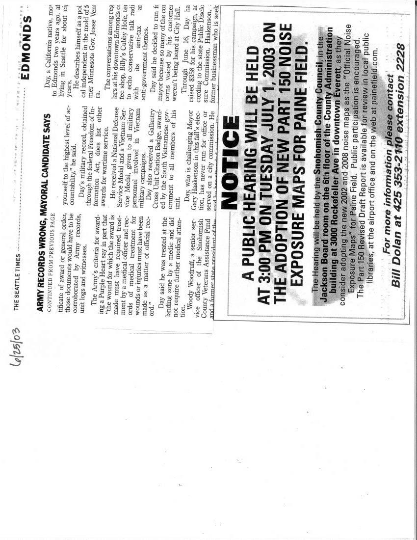
33 airport administrative office. Notice of the public hearing was distributed with each copy of the Revised Draft Report, on the airport s webpage, along with being published in the following newspapers (see proof of publication in the Appendix): Seattle Times Mukilteo Beacon Everett Herald Mukilteo Tribune The public hearing was held on June 30, 2003 at the Public Works Transportation Committee meeting of the Snohomish County Council. Airport staff briefed the committee. One written comment (see appendix) and no verbal comments were received. The County Council continued the Public Hearing to its legislative session on July 1, No further comments were received during the July 1 hearing and the County Council adopted the Noise Exposure Maps with the attached motion (see appendix). Snohomish County Airport/Paine Field Revised Draft Report/May 2003 Noise Exposure Map Update 24
34 Appendix Snohomish County Airport/Paine Field September 2003 Noise Exposure Map Update Appendix
35

36

37

38

39

40

41
42
43
44
45

46
Purpose and Need for the Proposed Project
 Purpose and Need for the Proposed Project Introduction Snohomish County Airport/Paine Field (PAE) is located in Snohomish County, Washington, approximately 20 miles north of Seattle. Figure A1 depicts
Van Nuys Airport December 2011 Updated 14 C.F.R. Part 150 Noise Exposure Maps page 1
 Updated 14 C.F.R. Part 150 Noise Exposure Maps page 1 1 INTRODUCTION The federal Airport Safety and Noise Abatement Act of 1979 1 ( ASNA ), as amended, defines procedures under which the federal government,
APPENDIX H 2022 BASELINE NOISE EXPOSURE CONTOUR
 APPENDIX H 2022 BASELINE NOISE EXPOSURE CONTOUR This appendix sets forth the detailed input data that was used to prepare noise exposure contours for 2022 Baseline conditions. H.1 DATA SOURCES AND ASSUMPTIONS
Concepts, Alternatives and Development Plan
 Concepts, Alternatives and Development Plan Introduction The purpose of this chapter is to present the Development Plan for Paine Field, in terms of both its concept and reasoning. This chapter provides
Boise Airport 14 CFR Part 150 Study Update
 Boise Airport 14 CFR Part 150 Study Update Updated Noise Exposure Maps and Noise Compatibility Program Prepared for: CITY OF BOISE Prepared by: HNTB Corporation CSHQA Wyle Laboratories Synergy Consulting
CHAPTER 6 NOISE EXPOSURE
 CHAPTER 6 NOISE EXPOSURE FAA requires that the NEM submitted for review represent the aircraft noise exposure for the year of submittal (in this case 2008) and for a future year (2013 for OSUA). However,
Part 150 Noise Compatibility Program Checklist
 Part 150 Noise Compatibility Program Checklist I. IDENTIFICATION AND SUBMISSION OF PROGRAM: Page Number A. Submission is properly identified: 1. 14 C.F.R Part 150 NCP? Yes, Cover, Fly Sheet, Cover Letter
6.C.1 AIRPORT NOISE. Noise Analysis and Land Use Impact Assessment FORT LAUDERDALE-HOLLYWOOD INTERNATIONAL AIRPORT ENVIRONMENTAL IMPACT STATEMENT
 6.C.1 AIRPORT NOISE The existing land uses are described in Chapter Five, Affected Environment. The methodologies used to develop the Geographic Information System (GIS) land use database, the estimated
> Aircraft Noise. Bankstown Airport Master Plan 2004/05 > 96
 Bankstown Airport Master Plan 2004/05 > 96 24.1 Why Is Aircraft Noise Modelled? Modelling of the noise impact of aircraft operations has been undertaken as part of this MP. Such modelling is undertaken
1.0 OUTLINE OF NOISE ANALYSIS...3
 Table of Contents 1.0 OUTLINE OF NOISE ANALYSIS...3 2.0 METHODOLOGY...3 2.1 BACKGROUND...3 2.2 COMPUTER MODELING...3 3.0 EXISTING NOISE ENVIRONMENT...4 3.1 EXISTING SANTA MONICA MUNICIPAL AIRPORT NOISE...4
APPENDIX C NOISE ANALYSIS
 APPENDIX C NOISE ANALYSIS KBE Final - 10/11/16 Existing Noise The extent of existing noise resulting from aircraft operations at Central Colorado Regional Airport (AEJ) was determined using the FAA-approved
T.F. Green Airport Part 150 Update Noise Exposure Map
 T.F. Green Airport Part 150 Update Noise Exposure Map Draft June 2010 Submitted to: Rhode Island Airport Corporation Submitted by: T.F. Green Airport 14 CFR Part 150 Update 2010 and 2020 NOISE EXPOSURE
Public Information Meeting
 CLT Noise Exposure Map Update Public Information Meeting February 5, 2015 1 Welcome and Introductions Charlotte Douglas International Airport Sponsor of the Noise Exposure Map (NEM) Update Certify the
Memorandum. Federal Aviation Administration. Date: June 19, Richard Doucette, Environmental Protection Specialist. From: To:
 Federal Aviation Administration Memorandum Date: June 19, 2008 From: To: Subject: Richard Doucette, Environmental Protection Specialist LaVerne Reid, Airports Division Manager John Donnelly, Regional Counsel
Washington Dulles International Airport (IAD) Aircraft Noise Contour Map Update
 Aircraft Noise Contour Map Update") Washington Dulles International Airport (IAD) Aircraft Noise Contour Map Update Ultimate ASV, Runway Use and Flight Tracks 4th Working Group Briefing 8/13/18 Meeting Purpose Discuss Public Workshop input
Washington Dulles International Airport (IAD) Aircraft Noise Contour Map Update Ultimate ASV, Runway Use and Flight Tracks 4th Working Group Briefing 8/13/18 Meeting Purpose Discuss Public Workshop input
Executive Summary. MASTER PLAN UPDATE Fort Collins-Loveland Municipal Airport
 Executive Summary MASTER PLAN UPDATE Fort Collins-Loveland Municipal Airport As a general aviation and commercial service airport, Fort Collins- Loveland Municipal Airport serves as an important niche
THE BURBANK-GLENDALE-PASADENA AIRPORT AUTHORITY S UPDATE REGARDING ITS NOISE IMPACT AREA REDUCTION PLAN AND ITS PART 161 STUDY SECOND QUARTER 2015
 THE BURBANK-GLENDALE-PASADENA AIRPORT AUTHORITY S UPDATE REGARDING ITS NOISE IMPACT AREA REDUCTION PLAN AND ITS PART 161 STUDY SECOND QUARTER 2015 Pursuant to the California Department of Transportation
THE BURBANK-GLENDALE-PASADENA AIRPORT AUTHORITY S UPDATE REGARDING ITS NOISE IMPACT AREA REDUCTION PLAN AND ITS PART 161 STUDY FIRST QUARTER 2015
 THE BURBANK-GLENDALE-PASADENA AIRPORT AUTHORITY S UPDATE REGARDING ITS NOISE IMPACT AREA REDUCTION PLAN AND ITS PART 161 STUDY FIRST QUARTER 2015 Pursuant to the California Department of Transportation
Recommendations for Northbound Aircraft Departure Concerns over South Minneapolis
 Recommendations for Northbound Aircraft Departure Concerns over South Minneapolis March 21, 2012 Noise Oversight Committee Agenda Item #4 Minneapolis Council Member John Quincy Background Summer of 2011
Part 150 and Part 161: Purpose, Elements, and Process
 Part 150 and Part 161: Purpose, Elements, and Process Presentation to: Noise Compatibility Committee January 29, 2015 Ted Baldwin Part 150, Airport Noise Compatibility Planning FAA created in response
Alternatives. Introduction. Range of Alternatives
 Alternatives Introduction Federal environmental regulations concerning the environmental review process require that all reasonable alternatives, which might accomplish the objectives of a proposed project,
Runway Length Analysis Prescott Municipal Airport
 APPENDIX 2 Runway Length Analysis Prescott Municipal Airport May 11, 2009 Version 2 (draft) Table of Contents Introduction... 1-1 Section 1 Purpose & Need... 1-2 Section 2 Design Standards...1-3 Section
Portable Noise Monitor Report
 Portable Noise Monitor Report Chicago O Hare International Airport Site 241 61 Grange Road, Elk Grove Village October 3, 215 through October 19, 215 USH8-ILH55-ILS28 Visit the O Hare Noise webpage on the
Draft Concept Alternatives Analysis for the Inaugural Airport Program September 2005
 Draft Concept Alternatives Analysis for the Inaugural Airport Program September 2005 Section 3 - Refinement of the Ultimate Airfield Concept Using the Base Concept identified in Section 2, IDOT re-examined
WELCOME! FORT LAUDERDALE-HOLLYWOOD INTERNATIONAL AIRPORT 14 CFR PART 150 NOISE AND LAND USE COMPATIBILITY STUDY
 WELCOME! FORT LAUDERDALE-HOLLYWOOD INTERNATIONAL AIRPORT 14 CFR PART 150 NOISE AND LAND USE COMPATIBILITY STUDY Public Information Workshop #2 January 2019 Station 1: Par t 150 Over view 14 CFR Part 150
Portable Noise Monitor Report
 Portable Noise Monitor Report Chicago O Hare International Airport Site 2117 5843 N. Christiana Avenue, Chicago July 14, 217 through August 2, 217 USH5-ILH15-ILS8-CHI39 Visit the O Hare Noise webpage on
Portable Noise Monitor Report
 Portable Noise Monitor Report Chicago O Hare International Airport Site 2198 5N67 Rochefort Lane, Wayne May 9, 218 through June 3, 218 USH6-ILH49-ILS25 Visit the O Hare Noise webpage on the Internet at
STAFF REPORT. Airport Land Use Plan Consistency Review: Santa Barbara Airport Master Plan. MEETING DATE: November 19, 2015 AGENDA ITEM: 7D
 STAFF REPORT SUBJECT: Airport Land Use Plan Consistency Review: Santa Barbara Airport Master Plan MEETING DATE: AGENDA ITEM: 7D STAFF CONTACT: Peter Imhof, Andrew Orfila RECOMMENDATION: Adopt findings
Buchanan Field. Airport Planning Program. FAR Part 150 Meeting. September 28, Master Plan FAR Part 150 Noise Study Strategic Business Plan
 Airport Planning Program Master Plan FAR Part 150 ise Study Strategic Business Plan FAR Part 150 Meeting September 28, 2006 Agenda Introduction Part 150 Study Working Paper Two Operational Alternatives
Portable Noise Monitor Report
 Portable Noise Monitor Report Chicago O Hare International Airport Site 213 475 W. Hutchinson Street, Chicago April 8, 217 through May 3, 217 USH5-ILH19-ILS1-CHI45 Visit the O Hare Noise webpage on the
Portable Noise Monitor Report
 Portable Noise Monitor Report Chicago O Hare International Airport Site 299 93 Wilshire Avenue, Elk Grove Village June 27, 217 through July 1, 217 USH8-ILH55-ILS28 Visit the O Hare Noise webpage on the
JOSLIN FIELD, MAGIC VALLEY REGIONAL AIRPORT DECEMBER 2012
 1. Introduction The Federal Aviation Administration (FAA) recommends that airport master plans be updated every 5 years or as necessary to keep them current. The Master Plan for Joslin Field, Magic Valley
THE BURBANK-GLENDALE-PASADENA AIRPORT AUTHORITY S UPDATE REGARDING ITS NOISE IMPACT AREA REDUCTION PLAN AND ITS PART 161 STUDY SECOND QUARTER 2017
 THE BURBANK-GLENDALE-PASADENA AIRPORT AUTHORITY S UPDATE REGARDING ITS NOISE IMPACT AREA REDUCTION PLAN AND ITS PART 161 STUDY SECOND QUARTER 2017 Pursuant to the California Department of Transportation
WELCOME! FORT LAUDERDALE-HOLLYWOOD INTERNATIONAL AIRPORT 14 CFR PART 150 NOISE AND LAND USE COMPATIBILITY STUDY
 WELCOME! FORT LAUDERDALE-HOLLYWOOD INTERNATIONAL AIRPORT 14 CFR PART 150 NOISE AND LAND USE COMPATIBILITY STUDY Public Information Workshop November 2017 1 14 CFR Part 150 Overview Establishes the methodology
The following criteria shall be applied within the boundaries of the AO District:
 Sec. 419 (a) Purpose AIRPORT OVERLAY DISTRICT (AO) The purpose of the Airport Overlay District is to regulate and restrict the height of structures, objects, or natural growth, regulate the locations of
Portable Noise Monitor Report
 Portable Noise Monitor Report Chicago O Hare International Airport Site 221 5716 N. Virginia Avenue, Chicago July 23, 214 through August 11, 214 Visit the O Hare Noise Management Webpage on the Internet
Portable Noise Monitor Report
 Portable Noise Monitor Report Chicago O Hare International Airport Site 2114 5516 N. Neenah Avenue, Chicago July 12, 217 through August 9, 217 USH5-ILH19-ILS1-CHI45 Visit the O Hare Noise webpage on the
PLEASE READ Proposal for Sustainable Service
 IMPORTANT PLEASE READ 019 Proposal for Sustainable Service 019 Service Change Proposal IMPLEMENT A SUSTAINABLE NETWORK Everett Transit completed its Long Range Plan in May, and the plan was adopted by
Noise Exposure
 4-1 4. FAR Part 150 guidelines require the evaluation of a five-year future forecast condition in the analysis of noise exposure at an airport. This section documents the expected future operating conditions
CHAPTER FOUR RECOMMENDED NOISE COMPATIBILITY PROGRAM MEASURES
 CHAPTER FOUR RECOMMENDED NOISE COMPATIBILITY PROGRAM MEASURES This chapter provides the detailed descriptions of the recommended Part 150 noise abatement, land use management, and program management measures
Appendix A. Meeting Coordination. Appendix A
 Appendix A Meeting Coordination Appendix A Philadelphia International Airport Noise Compatibility Program Update FAR Part 150 Noise Compatibility Program Update Report Prepared by: DMJM Aviation AECOM
STAFF REPORT. Airport Land Use Consistency Determination Betteravia Plaza. MEETING DATE: January 21, 2016 AGENDA ITEM: 8D
 STAFF REPORT SUBJECT: Airport Land Use Consistency Determination Betteravia Plaza MEETING DATE: AGENDA ITEM: 8D STAFF CONTACT: Andrew Orfila RECOMMENDATION: Adopt findings for the Betteravia Plaza project
 Burlington )@=8796?;9!-9?5=93?7;938!(7=
 Part 150 Committee April 24, 2008
 Part 150 Committee April 24, 2008 Part 150 Committee Aircraft Operations Inputs Flight Track and Runway Use Inputs DNL Contour Results SEL Contours Noise Measurement Results Public Comment and Questions
Airport Noise Management System
 July Monthly Report Airport Noise Management System Chicago O Hare International Airport City of Chicago Department of Aviation Visit the Community Noise Resource Center on the Internet at www.flychicago.com
STAFF REPORT. Airport Land Use Plan Consistency Review: Old Town Village Mixed Use Project City of Goleta. MEETING DATE: June 18, 2015 AGENDA ITEM: 5M
 STAFF REPORT SUBJECT: Airport Land Use Plan Consistency Review: Old Town Village Mixed Use Project City of Goleta MEETING DATE: AGENDA ITEM: 5M STAFF CONTACT: Peter Imhof, Andrew Orfila RECOMMENDATION:
Welcome to Public Information Workshop 1. San Francisco International Airport FAR Part 150 Study Update Noise Exposure Map Report
 Welcome to Public Information Workshop 1 Chetcuti Room, City of Milbrae 450 Poplar Avenue Milbrae, California 94030 Wednesday, June 4, 2014 5:45 p.m. to 6:45 p.m. PDT The FAA typically uses the airport
Forecast of Aviation Activity
 DETROIT METROPOLITAN WAYNE COUNTY AIRPORT FAR PART 150 NOISE COMPATIBILITY STUDY UPDATE CHAPTER B FORECAST OF AVIATION ACTIVITY Forecast of Aviation Activity Introduction This chapter summarizes past aviation
14 CFR PART 150 NOISE AND LAND USE COMPATIBILITY STUDY
 14 CFR PART 150 NOISE AND LAND USE COMPATIBILITY STUDY Technical Committee Meeting #3 March 7, 2018 1 Agenda Introductions Review of the Role of the TC Meeting Facilitator Review of Prior TC Meetings Public
St. Paul Downtown Airport (STP)
") Reliever Airports: NOISE ABATEMENT PLAN St. Paul Downtown Airport (STP) 1 INTRODUCTION The noise abatement plan for the St. Paul Downtown Airport (STP) was prepared in recognition of the need to make the
Reliever Airports: NOISE ABATEMENT PLAN St. Paul Downtown Airport (STP) 1 INTRODUCTION The noise abatement plan for the St. Paul Downtown Airport (STP) was prepared in recognition of the need to make the
2015 ANNUAL NOISE REPORT
 2015 ANNUAL NOISE REPORT MASSACHUSETTS PORT AUTHORITY L.G. HANSCOM FIELD BEDFORD, MA 01730 PREPARED BY AMBER GOODSPEED SUBMITTED TO HANSCOM FIELD ADVISORY COMMISSION July 2016 Connecting with our communities
Martin County Airport / Witham Field Noise Abatement Departure Profile (NADP) Demonstration Technical Report March 2010
 Demonstration Technical Report March 2010") Martin County Airport / Witham Field Noise Abatement Departure Profile (NADP) Demonstration Technical Report March 2010 Prepared for: Federal Aviation Administration (FAA) Orlando Airport District Office
Martin County Airport / Witham Field Noise Abatement Departure Profile (NADP) Demonstration Technical Report March 2010 Prepared for: Federal Aviation Administration (FAA) Orlando Airport District Office
Chapter 1 Introduction and Project Overview
 Chapter 1 Introduction and Project Overview Kittitas County in cooperation with the Federal Aviation Administration (FAA) is updating the Airport Master Plan for Bowers Field Airport (FAA airport identifier
Airport Noise Management System
 4 th Quarter 2009 Quarterly Report Airport Noise Management System City of Chicago Department of Aviation Visit the Community Noise Resource Center on the Internet at www.flychicago.com Airport Noise Management
Ted Stevens Anchorage International Airport (FAR) Part 150 Noise Compatibility Study Update
 Part 150 Noise Compatibility Study Update") Ted Stevens Anchorage International Airport (FAR) Part 150 Noise Compatibility Study Update Study Input Committee Summary Notes February 29, 2012 1:30 p.m. Airfield Maintenance Facility NAME Staff and
Ted Stevens Anchorage International Airport (FAR) Part 150 Noise Compatibility Study Update Study Input Committee Summary Notes February 29, 2012 1:30 p.m. Airfield Maintenance Facility NAME Staff and
Forecasts of Aviation Activity
 Forecasts of Aviation Activity Introduction This is the second chapter in the Master Plan Update document. The first chapter identified the existing airport facilities, as well as physical conditions on
NAPLES MUNICIPAL AIRPORT
 NAPLES MUNICIPAL AIRPORT F A R P A R T 150 N O I S E E X P O S U R E M A P U P D A T E Prepared under Federal Aviation Regulations, Part 150 November 2000 NAPLES MUNICIPAL AIRPORT Tke Best LiiM% Aimrt
PUBLIC INFORMATION WORKSHOP #4 / PUBLIC HEARING November 8 / 9, 2006
 PUBLIC INFORMATION WORKSHOP #4 / PUBLIC HEARING November 8 / 9, 2006 A Noise Compatibility Study, prepared under Part 150 of the Federal Aviation Regulations (FAR), is a voluntary program aimed at balancing
Master Plan & Noise Compatibility Study Update
 Working Document-Subject to Change, March 2010 Master Plan & Noise Compatibility Study Update (14 CFR Part 150) TECHNICAL ADVISORY COMMITTEE March 24, 2010 Working Document-Subject to Change, March 2010
AIRPORT MASTER PLAN. Newport State Airport. Draft. (Colonel Robert F. Wood Airpark) THE Louis Berger Group, INC. Prepared for: Prepared by:
 THE Louis Berger Group, INC. Prepared for: Prepared by:") Draft AIRPORT MASTER PLAN Newport State Airport () Prepared for: 2000 Post Road Warwick, Rhode Island 02886-1533 THE Louis Berger Group, INC. 20 Corporate Woods Boulevard Albany, New York 12211-2370 Prepared
Draft AIRPORT MASTER PLAN Newport State Airport () Prepared for: 2000 Post Road Warwick, Rhode Island 02886-1533 THE Louis Berger Group, INC. 20 Corporate Woods Boulevard Albany, New York 12211-2370 Prepared
Airport Noise Management System Chicago O Hare International Airport
 November 218 Monthly Report Airport Noise Management System Chicago O Hare International Airport Visit the O Hare Noise webpage on the Internet at www.flychicago.com/ordnoise Airport Noise Management System
Chapter Six ALP Drawings. Tacoma Narrows Airport. Master Plan Update
 Chapter Six ALP Drawings Master Plan Update The master planning process for the (Airport) has evolved through efforts in the previous chapters to analyze future aviation demand, establish airside and landside
1. Introduction History of FAR Part Noise Compatibility Program Planning Process Noise Exposure Maps.
 1-1 1. 1.1. History of FAR Part 150 The Part 150 Noise Compatibility Program originated from the Aviation Safety and Noise Abatement Act of 1979 1. This Act provides the regulatory guidance used to develop
APPENDIX D-12. Modeled Aircraft Operations and Integrated Noise Model Inputs for Noise Assessment of Year 2025 Build Alternatives 3 and 4
 APPENDIX D-12 Modeled Aircraft Operations and Integrated Noise Model Inputs for Noise Assessment of Year 2025 Build Alternatives 3 and 4 In order to compare to current planning policies of Loudoun and
Airport Planning Area
 PLANNING AREA POLICIES l AIRPORT Airport Planning Area LOCATION AND CONTEXT The Airport Planning Area ( Airport area ) is a key part of Boise s economy and transportation network; it features a multi-purpose
Washington Dulles International Airport (IAD) Aircraft Noise Contour Map Update. 6th Working Group Briefing 1/7/19
 Aircraft Noise Contour Map Update. 6th Working Group Briefing 1/7/19") Washington Dulles International Airport (IAD) Aircraft Noise Contour Map Update 6th Working Group Briefing 1/7/19 Study Purpose Agenda Background Summary of last stakeholder meetings Refresher on DNL,
Washington Dulles International Airport (IAD) Aircraft Noise Contour Map Update 6th Working Group Briefing 1/7/19 Study Purpose Agenda Background Summary of last stakeholder meetings Refresher on DNL,
STUDY OVERVIEW MASTER PLAN GOALS AND OBJECTIVES
 INTRODUCTION An Airport Master Plan provides an evalua on of the airport s avia on demand and an overview of the systema c airport development that will best meet those demands. The Master Plan establishes
AIRPORT MASTER PLAN FOR. charles B. WHEELER DOWNTOWN AIRPORT KANSAS CITY, MISSOURI
 AIRPORT MASTER PLAN FOR charles B. WHEELER DOWNTOWN AIRPORT KANSAS CITY, MISSOURI Prepared For The City of Kansas City, Missouri By Coffman Associates, Inc. January 2004 "The contents of these documents
Capacity Analysis and Facility Requirements
 Capacity Analysis and Facility Requirements Introduction The capacity analysis for Paine Field is composed of two distinct elements: the ability of airport facilities to accommodate existing and projected
PLU Airport Master Plan. Master Plan Advisory Committee (MPAC) Meeting #4 March 19, 2018
 Meeting #4 March 19, 2018") PLU Airport Master Plan Master Plan Advisory Committee (MPAC) Meeting #4 March 19, 2018 Meeting Agenda 1. Master Plan Status [5 Minutes] 2. Preferred Forecasts [15 Minutes] 3. Runway Length Options [45
PLU Airport Master Plan Master Plan Advisory Committee (MPAC) Meeting #4 March 19, 2018 Meeting Agenda 1. Master Plan Status [5 Minutes] 2. Preferred Forecasts [15 Minutes] 3. Runway Length Options [45
Technical Memorandum. Synopsis. Steve Carrillo, PE. Bryan Oscarson/Carmen Au Lindgren, PE. April 3, 2018 (Revised)
") Appendix D Orange County/John Wayne Airport (JWA) General Aviation Improvement Program (GAIP) Based Aircraft Parking Capacity Analysis and General Aviation Constrained Forecasts Technical Memorandum To:
Appendix D Orange County/John Wayne Airport (JWA) General Aviation Improvement Program (GAIP) Based Aircraft Parking Capacity Analysis and General Aviation Constrained Forecasts Technical Memorandum To:
Document prepared by MnDOT Office of Aeronautics and HNTB Corporation. MINNESOTA GO STATE AVIATION SYSTEM PLAN
 LAST UPDATE JULY 2013 Acknowledgements The preparation of this document was financed in part by a grant from the Federal Aviation Administration (Project No: 3-27-0000-07-10), with the financial support
Comparison Between Old and New ALUC Plans
 A P P E N I X H Comparison Between Old and New ALUC Plans OVERVIEW This Placer County Airport Land Use Compatibility Plan (ALUCP) sets forth land use compatibility criteria for the environs of Auburn Municipal,
Portable Noise Monitor Report
 Portable Noise Monitor Report Chicago O Hare and Midway International Airports Site 217 1149 Candlewood Drive, Downers Grove May 17, 214 through May 31, 214 Visit the O Hare and Midway Noise Management
Airport Noise Management System Chicago O Hare International Airport
 December 218 Monthly Report Airport Noise Management System Chicago O Hare International Airport Visit the O Hare Noise webpage on the Internet at www.flychicago.com/ordnoise Airport Noise Management System
The purpose of this Demand/Capacity. The airfield configuration for SPG. Methods for determining airport AIRPORT DEMAND CAPACITY. Runway Configuration
 Chapter 4 Page 65 AIRPORT DEMAND CAPACITY The purpose of this Demand/Capacity Analysis is to examine the capability of the Albert Whitted Airport (SPG) to meet the needs of its users. In doing so, this
RTIA Runway Utilization Discussion Paper
 RTIA Runway Utilization Discussion Paper December 2003 1.0 Introduction The Airport Noise Advisory Panel (ANAP) is a voluntary committee formed by the Airport Authority of Washoe County (AAWC) Board of
APPENDIX H NOISE COMPATIBILITY PROGRAM ALTERNATIVES
 CHICAGO MIDWAY INTERNATIONAL AIRPORT FAR PART 150 NOISE COMPATIBILITY STUDY UPDATE DRAFT APPENDIX H NOISE COMPATIBILITY PROGRAM ALTERNATIVES This appendix discusses the consideration and evaluation of
Appendix D Project Newsletters. Tacoma Narrows Airport. Master Plan Update
 Appendix D Project Newsletters Tacoma Narrows Airport Master Plan Update This appendix contains the newsletters distributed throughout the project. These newsletters provided updates and information on
Memorandum. Approval of Noise Compatibility Date SEP 7 Program for Akron-Canton Regional Airport, North Canton, Ohio ACT! IQN:
 Ow U.5. Department of Transportation Federal Aviation Administration Memorandum Subject -: ACT! IQN: Approval of Noise Compatibility Date SEP 7 Program for Akron-Canton Regional Airport, North Canton,
Learn more and comment. See page 10 for details. Proposed Fall 2018 / Spring 2019 SERVICE EXPANSION. and FARE CHANGE
 Learn more and comment. See page 10 for details. Proposed Fall 2018 / Spring 2019 SERVICE EXPANSION and FARE CHANGE Proposed Fall 2018/Spring 2019 Service Expansion & Fare Change Community Transit proposes
FAR Part 150 Study Advisory Committee July 14, 2003 Meeting Summary Members Present Tony Adyniec Al Piojda Roseann Dieck
 FAR Part 150 Study Advisory Committee July 14, 2003 Meeting Summary Members Present Tony Adyniec Al Piojda Roseann Dieck Raymond Glowacki Edward Richardson Elizabeth Kopplin Ralph Voltner Pat Stoner Barry
DENVER INTERNATIONAL AIRPORT 2016 IGA NOISE RELEASE STUDY. June 22, 2016
 DENVER INTERNATIONAL AIRPORT 2016 IGA NOISE RELEASE STUDY June 22, 2016 INTRODUCTION This Noise Release Study was prepared pursuant to Section 4.5.3 Noise Studies of the Intergovernmental Agreement dated
Airport Noise Management System Chicago O Hare International Airport
 March 218 Monthly Report Airport Noise Management System Chicago O Hare International Airport Visit the O Hare Noise webpage on the Internet at www.flychicago.com/ordnoise Airport Noise Management System
Washington Dulles International Airport (IAD) Aircraft Noise Contour Map Update. Ultimate Operations 5th Working Group Briefing 9/25/18
 Aircraft Noise Contour Map Update. Ultimate Operations 5th Working Group Briefing 9/25/18") Washington Dulles International Airport (IAD) Aircraft Noise Contour Map Update Ultimate Operations 5th Working Group Briefing 9/25/18 Meeting Purpose Discuss methodology of Ultimate build scenario operations
Washington Dulles International Airport (IAD) Aircraft Noise Contour Map Update Ultimate Operations 5th Working Group Briefing 9/25/18 Meeting Purpose Discuss methodology of Ultimate build scenario operations
According to FAA Advisory Circular 150/5060-5, Airport Capacity and Delay, the elements that affect airfield capacity include:
 4.1 INTRODUCTION The previous chapters have described the existing facilities and provided planning guidelines as well as a forecast of demand for aviation activity at North Perry Airport. The demand/capacity
10-10F, DC-10-30, DC-10-30F, DC-10-40, MD-10-30F, MD-11,
 [Federal Register: July 10, 2003 (Volume 68, Number 132)] [Rules and Regulations] [Page 41063-41065] From the Federal Register Online via GPO Access [wais.access.gpo.gov] [DOCID:fr10jy03-6] DEPARTMENT
Airport Noise Management System Quarterly Report. Chicago Midway International Airport
 Airport Noise Management System Quarterly Report City of Chicago Department of Aviation 3rd Quarter 2008 July, August and September Visit the Community Resource Center on the Internet at www.flychicago.com
Notice of Extended Comment Period for an Intent to Adopt a Negative Declaration
 County of Santa Clara Department of Planning and Development Planning Office County Government Center, East Wing, 7 th Floor 70 West Hedding Street San Jose, California 95110-1705 (408) 299-5770 FAX (408)
FORECASTING FUTURE ACTIVITY
 EXECUTIVE SUMMARY The Eagle County Regional Airport (EGE) is known as a gateway into the heart of the Colorado Rocky Mountains, providing access to some of the nation s top ski resort towns (Vail, Beaver
Noise Compatibility Year End, 2012
 Year End, 2012 April 5, 2013 Noise Highlights of 2012 Airport operations for Year 2012 were down 3.97%, compared to Year 2011. The FAA issued a Record of Approval (ROA) for the new Program (NCP) Update
Minneapolis-St. Paul International Airport (MSP)
") 2 nd Quarter 2016 Minneapolis-St. Paul International Airport (MSP) Public Input Meeting Metropolitan Airports Commission Noise Program Office April 27, 2016 PUBLIC INPUT MEETING Meeting Goals To hear the
2 nd Quarter 2016 Minneapolis-St. Paul International Airport (MSP) Public Input Meeting Metropolitan Airports Commission Noise Program Office April 27, 2016 PUBLIC INPUT MEETING Meeting Goals To hear the
Tinker Air Force Base, Oklahoma
 Table 5.4 Generalized Zoning within the Tinker AFB Clear Zones and Accident Potential Zones (Off-Installation) Category Acreage Residential 1,486 Commercial 191 Industrial 128 Public/Quasi-public 0 Recreational/Open/Agricultural/Low
Lopez Island Airport Master Plan Update. Public Meeting June 15, 2017
 Lopez Island Airport Master Plan Update Public Meeting June 15, 2017 Master Plan Update Team Reid Middleton/Everett, WA Shannon Kinsella, Project Manager Melania Haagsma, Project Engineer Mead & Hunt/Tulsa,
14 CFR PART 150 NOISE AND LAND USE COMPATIBILITY STUDY. Technical Committee Meeting #2 August 23, 2017
 14 CFR PART 150 NOISE AND LAND USE COMPATIBILITY STUDY Technical Committee Meeting #2 August 23, 2017 1 Agenda Introductions Review of the Role of the TC Meeting Facilitator Review of TC Meeting No.1 Data
September HMMH Report Prepared for: RALEIGH-DURHAM AIRPORT AUTHORITY Raleigh-Durham International Airport, North Carolina
 TECHNICAL REPORT ON PREPARATION OF DAY-NIGHT AVERAGE SOUND LEVEL (DNL) CONTOURS OF AIRCRAFT NOISE DURING 2008 RALEIGH-DURHAM INTERNATIONAL AIRPORT NORTH CAROLINA September 2010 HMMH Report 301254.000 Prepared
PREFACE. Service frequency; Hours of service; Service coverage; Passenger loading; Reliability, and Transit vs. auto travel time.
 PREFACE The Florida Department of Transportation (FDOT) has embarked upon a statewide evaluation of transit system performance. The outcome of this evaluation is a benchmark of transit performance that
Airport Noise Management System Chicago O Hare International Airport
 August 218 Monthly Report Airport Noise Management System Chicago O Hare International Airport Visit the O Hare Noise webpage on the Internet at www.flychicago.com/ordnoise Airport Noise Management System
Addendum - Airport Development Alternatives (Chapter 6)
") Bowers Field Addendum - Airport Development Alternatives (Chapter 6) This addendum to the Airport Development Alternatives chapter includes the preferred airside development alternative and the preliminary
Bowers Field Addendum - Airport Development Alternatives (Chapter 6) This addendum to the Airport Development Alternatives chapter includes the preferred airside development alternative and the preliminary
Interstate 90 and Mercer Island Mobility Study APRIL Commissioned by. Prepared by
 Interstate 90 and Mercer Island Mobility Study APRIL 2017 Commissioned by Prepared by Interstate 90 and Mercer Island Mobility Study Commissioned by: Sound Transit Prepared by: April 2017 Contents Section