September HMMH Report Prepared for: RALEIGH-DURHAM AIRPORT AUTHORITY Raleigh-Durham International Airport, North Carolina
|
|
|
- Primrose Garrett
- 5 years ago
- Views:
Transcription
1 TECHNICAL REPORT ON PREPARATION OF DAY-NIGHT AVERAGE SOUND LEVEL (DNL) CONTOURS OF AIRCRAFT NOISE DURING 2008 RALEIGH-DURHAM INTERNATIONAL AIRPORT NORTH CAROLINA September 2010 HMMH Report Prepared for: RALEIGH-DURHAM AIRPORT AUTHORITY Raleigh-Durham International Airport, North Carolina
2 (This page intentionally left blank)
3 TECHNICAL REPORT ON PREPARATION OF DAY-NIGHT AVERAGE SOUND LEVEL (DNL) CONTOURS OF AIRCRAFT NOISE DURING 2008 RALEIGH-DURHAM INTERNATIONAL AIRPORT NORTH CAROLINA HMMH Report No September 2010 Prepared for: RALEIGH-DURHAM AIRPORT AUTHORITY Raleigh-Durham International Airport, North Carolina Prepared by: David A. Crandall Gene Reindel Robin Gardner Robert Mentzer HARRIS MILLER MILLER & HANSON INC. 77 South Bedford Street Burlington, MA 01803
4 (This page intentionally left blank)
5 HMMH Report No page 1 TABLE OF CONTENTS 1 INTRODUCTION CONTOUR PREPARATION PROCESS Improvements in Noise Modeling Practices Noise Model Versions Used at RDU Improvements in Development of Modeling Inputs DESCRIPTION OF THE INPUT DATA Airport Layout Aircraft Operations Runway Use Direction of Traffic Flow Use of Individual Runways Flight Tracks and Flight Track Use Aircraft Altitude Profile Meteorological Conditions Terrain Data NOISE CONTOURS Annual Average Day Contours for All Operations on All Runways Comparison of 2007 and 2008 Annual Average Day DNL Contours Annual Average Day Contours for All Operations on Runways 5L and 5R Annual Average Day Contours for All Operations on Runways 23L and 23R COMPARISON OF THE 2008 MODELED NOISE CONTOURS AND 2008 NOISE MEASUREMENTS SINGLE EVENT CONTOURS REFERENCES APPENDIX A JET ARRIVAL AND DEPARTURE PROCEDURES...A-1
6 HMMH Report No page 2 LIST OF FIGURES Figure 1 Raleigh-Durham INTL Airport Diagram...12 Figure Flight Track Sample for Operations on Runways 5L and 5R...23 Figure Flight Track Sample for Operations on Runways 23L and 23R...25 Figure Annual Average Day Contours for All Operations on All Runways...31 Figure Annual Average Day Contours Compared to 2008 Annual Average Day Contours...33 Figure Annual Average Day Contours for All Operations on Runways 5L and 5R...35 Figure Annual Average Day Contours for All Operations on Runways 23L and 23R...37 Figure 8 Sound Exposure Level Contours for Select Commercial Aircraft...48 Figure 9 Sound Exposure Level Contours for Select General Aviation Aircraft...49 Figure A-1 RDU Jet Arrival and Departure Procedures December A-3
7 HMMH Report No page 3 LIST OF TABLES Table 1 Historical Use of Noise Models for Noise Contours...8 Table 2 Annual Average Day Number of Operations Table 3 Comparison of Annual Traffic Flow to Table 4 Runway Use Percentages for the Modeled Annual Average Day Table 5 Comparison of Land Use Areas within Noise Contours to Table 6 Comparison of Modeled and Measured Annual DNL Values...45
8 HMMH Report No page 4 (This page intentionally left blank)
9 HMMH Report No page 5 1 INTRODUCTION This report presents Day-Night Average Sound Level (DNL) noise contours for calendar year 2008 aircraft operations at Raleigh-Durham International Airport (RDU). Harris Miller Miller & Hanson Inc. (HMMH) prepared these contours on behalf of the Raleigh-Durham Airport Authority (RDUAA). 1 Prior to 2001, with the exception of 1995, a relatively stable group of airlines served RDU, with minor variation during the year, and with incremental changes in activity from year to year. In February of 1995 American Airlines, the dominant air carrier at RDU, ceased hub operations at RDU and significantly reduced operations at RDU. In June of 1995, Midway Airlines began hub operations at RDU. 2 Due to the events on September 11, 2001 many airlines substituted regional jets for their previously utilized larger air carrier jet models. In 2001 Midway Airlines operations became intermittent and ceased completely by the end of calendar year Overall, from 2002 to 2003, total operations at RDU declined approximately eight percent, primarily due to an eleven percent reduction in commercial (passenger and cargo) jet operations. However in 2004 compared to 2003, the total operations at RDU increased approximately eleven percent, largely due to an increase in regional jet operations. Total annual operations remained relatively constant from 2004 through RDU experienced an approximate nine percent decrease in total operations in 2008 compared to 2007 (252,708 total operations in 2007 compared to 229,406 operations in 2008). Total operations of air carrier, cargo and regional jets decreased approximately ten percent (Approximately 378 average day operations in 2008 compared to 486 average day operations in 2007). General aviation jet operations decreased approximately twenty-one percent and propeller aircraft operations as a whole (i.e. combining commercial and general aviation) decreased approximately six percent. Military operations increased approximately thirty-five percent compared to 2007 levels, which was primarily due to the local North Carolina Army National Guard unit preparing and training for an overseas deployment that started in March During calendar year 2008, Runway 5R/23L was often closed for rehabilitation between May and November (inclusive). These runway closures had the effect of reducing operations on Runway 5R/23L and increasing operations on Runway 5L/23R. In addition, on October 26, 2008 Terminal 2 opened and replaced Terminal C. Terminal 2 is adjacent to Runway 5L/23R and opened with a single concourse and includes 19 gates for aircraft operations. This terminal replacement had a minor effect on runway use for passenger commercial aircraft towards the end of calendar year 2008 as Delta Airlines, and regional affiliate Comair, transferred from the Terminal 1 (formerly called Terminal A), which is adjacent to Runway 5R/23L to Terminal 2. Although many factors influence runway use, all else being equal, operators prefer to use the closest available runway to minimize taxi times. 1 HMMH previously prepared DNL contours for RDU for an annualized set of operations spanning 1987 and 1988, and for each calendar year from 1990 through 2007, inclusive. Section 7 lists the previous reports. 2 The 1995 contour report provides additional descriptions of operations in The 2001, 2002, and 2003 contour reports provide detailed descriptions of operations in those years.
10 HMMH Report No page 6 Figure 5 provides a graphic comparison of the 2007 and 2008 contours. The 2008 contours are comparable to those for 2007 in most areas with some notable changes associated with the aforementioned changes in runway use. Overall, the contour area decreased slightly. Section 4.2 provides additional discussion regarding the changes between the 2007 and 2008 contours. Sections 2 and 3 describe the processes used to develop the noise contours and collect and refine the required input data. HMMH has refined the contour preparation process each year to use the latest available technologies. For example, the flight track modeling process has evolved from use of a small sample of flight tracks traced from the radar scope at the air traffic control tower to a highly advanced process that takes into account the entire set of calendar year flight tracks captured by the RDUAA flight tracking system. The latest methods greatly improve the sensitivity of the model to differences in individual aircraft type, runway use, track geometry and altitude profiles. Section 4 of this report presents the resulting DNL contours for total annual operations at RDU and for the two major operating modes at the airport; i.e., all operations in northeast flow (Runways 5L and 5R), and all operations in southwest flow (Runways 23L and 23R). Section 4 also compares the 2008 DNL contours to those representing 2007 RDU aircraft operations. Section 5 compares the 2008 annual average modeled DNL contours to the 2008 annual average measured DNL at each noise monitoring site that was operational during a portion of the year. Section 6 presents single event contours for select aircraft that operated at RDU in 2008 and provides some context of how those aircraft types relate to the noise environment around RDU. Section 7 lists the various reports that have documented annual noise contours at RDU.
11 HMMH Report No page 7 2 CONTOUR PREPARATION PROCESS HMMH prepared the 2008 contours using the most current version of the Integrated Noise Model (INM 7.0b) that the Federal Aviation Administration (FAA) provides for use at civil airports. The standard approach for preparation of noise contours requires compilation and input of several categories of information about the operation of an airport, for input into the noise model: 1) Airport Layout: Location, length and orientation of all runways. 2) Operation Numbers: Numbers of departures, arrivals and pattern operations by each type of aircraft during an annual average day. The number of operations on this day is the number of operations during the year divided by the number of days in the year. For DNL calculation purposes, the 24-hour day is divided into two parts, daytime ( ) and nighttime ( ). The sound levels of nighttime flights are weighted with an additional 10 decibels in the DNL computation procedure (which has the same effect as counting each night operation to contribute the same amount of noise energy as ten equivalent operations in the day). 3) Runway Use: Percentage of operations on each runway by each type of aircraft. 4) Flight Tracks: Paths followed by aircraft departing from, or arriving to, each runway. 5) Flight Track Use: Percentage of operations by each aircraft type that use each flight track. 6) Aircraft Altitude Profile: Height of the aircraft from the ground. 7) Meteorological Conditions: The average weather conditions. 8) Terrain Data: Elevation of the ground surrounding, and on, the airport. Section 3 describes the above inputs for the 2008 contour development. INM computes the noise exposure around an airport as a grid of values of the DNL. This grid information is the standard input for the widely accepted contouring program (NMPlot 4 ) that develops the DNL contours based on the INM-calculated grid point values. 2.1 Improvements in Noise Modeling Practices HMMH has continuously improved the methods used in developing the noise modeling inputs for RDU to ensure that the modeling process used each year reflects accepted industry best practices and a historical perspective of this evolution follows Noise Model Versions Used at RDU HMMH has always followed the practice of using the most advanced noise modeling technology to prepare contours for RDU. The INM includes FAA-developed noise and performance data for a broad range of aircraft types. Periodically, the FAA provides updates to these databases: data from 4 NMPlot was authored by Wasmer Consulting with sponsorship from the United States Air Force. (
12 HMMH Report No page 8 Database 9 was used to prepare the 1991 and 1992 noise contours; and database 10 was used to prepare the 1993 through 1998 contours. With the FAA s release of INM 6.0b, these noise and performance databases were incorporated with the model. Table 1 presents the noise models used for development of DNL contours at RDU. Table 1 Historical Use of Noise Models for Noise Contours Year Noise Model NOISEMAP 1999 INM 6.0b INM 6.0c INM INM 6.2a 2006 INM INM 7.0a 2008 INM 7.0b INM 6.2a included improved modeling algorithms and a noise and performance database for more aircraft types. One significant difference between INM 6.1 and 6.2a is that the more recent version has updated aircraft noise and performance databases to better reflect the current in-service fleet. This change generally results in slightly larger noise contours for otherwise identical modeling runs. INM 7.0 was a major update to the model in terms of program organization with the inclusion of the FAA s Helicopter Noise Model (HNM) and update of several algorithms. Before the release of INM 6.0b, the FAA approved use of a U. S. Air Force model, NOISEMAP, in addition to INM. HMMH used NOISEMAP at RDU prior to 1999, because it offered several advantages over the then current INM versions. For example, NOISEMAP provided the capability to model helicopter activity and fixed-wing pattern activity (such as touch-and-go patterns), which the earlier versions of the INM did not support. HMMH converted to the use of INM in 1999, when the capabilities of that model justified the switch. The current version of the INM is the best model to use at RDU and includes the capability to model helicopter and pattern operations Improvements in Development of Modeling Inputs HMMH prepared the contours for 1987/88 based on operations data, radar information and noise measurements obtained during The 1990 contours used the operations patterns (i.e., runway use, flight track locations and flight track use) from 1987, adjusted to reflect the numbers and types of aircraft observed during Beginning in 1991, the RDUAA obtained access to radar information from the FAA computer-based Automated Radar Terminal System (ARTS). The ARTS data provided detailed flight track information for the full range of aircraft using RDU. A sampling of the actual flight tracks at RDU was obtained on a quarterly basis. The RDUAA provided runway use logs for eight months of the year. With the assistance of the FAA and RDUAA staff, HMMH used 1991 operations patterns to prepare the 1991 contours. In 1992, HMMH followed a process similar to that used in However, the contours were based on a larger sample of ARTS data, and the RDUAA provided runway use logging for nearly every day in the year. Starting in 1993, HMMH and the RDUAA staff made a particularly significant improvement in the modeling process related to the use of actual ARTS flight tracks to model individual operations. In 1993 HMMH developed a preprocessor for NOISEMAP, called ARTSMAP, which converts
13 HMMH Report No page 9 ARTS flight tracks into modeling flight tracks. ARTSMAP represented a significant step forward in the process for modeling aircraft noise exposure because it eliminated the need to approximate actual flight tracks with a far smaller number of modeling flight tracks. ARTSMAP also modeled aircraft operations by each specific aircraft type using flight tracks and altitude profiles actually flown by that type of aircraft. For example, each modeled Boeing 727 used flight tracks and altitude profiles from 727 operations at RDU. The result of these modeling changes is increased accuracy in modeling the natural dispersion of flight tracks and flight altitudes than was previously possible. This process was used to develop the 1993 through 1998 DNL contours for RDUAA. HMMH converted the modeling process from NOISEMAP to the INM for the 1999 noise contours. For the 1999 and 2000 contours, HMMH used the annual sample of ARTS flight tracks to develop a set of modeled tracks for each flight corridor. These tracks served to model both the centerline as well as lateral dispersion for each corridor. For the 2001 model flight tracks, HMMH compared 2001 data to the model tracks developed for the 2000 contours and modified the 2000 model tracks to represent 2001 ARTS data. The 2002 model tracks were likewise developed from the 2001 model tracks and the 2002 ARTS data. This process, using current data to update the previous model tracks, was repeated to develop model tracks for the 2003 and 2004 contours. HMMH prepared the 2005 through 2008 contours using an INM pre-processor, named RealContours. 5 RealContours prepares each available aircraft flight track during the course of the year for input into INM. In many ways, RealContours is similar to ARTSMAP, although RealContours uses the INM noise model instead of the NOISEMAP model. The 2007 and 2008 contours also included the effects of elevation changes around the airport. RealContours takes the maximum possible advantage of the INM s capabilities and automates the process of preparing the INM inputs directly from recorded flight operations and models the full range of aircraft activity as precisely as possible. RealContours improves the precision of modeling by using operations monitoring results in the following areas: Directly converts the flight track recorded by the airport for every identified aircraft operation to an INM track, rather than assigning all operations to a limited number of prototypical tracks; Models each operation on the specific runway that it actually used, rather than applying a generalized distribution to broad ranges of aircraft types to an average of runway use; Models each operation in the time-of-day in which that operation occurred; Selects the specific airframe and engine combination to model, on an operation-by-operation basis, by using the aircraft type designator associated with the flight plan and, if available for commercial operations, the published composition of the individual operator s aircraft inventory; and Compares each flight profile to the standard INM aircraft profiles and selects the best match for each flight. Flight tracks were provided from RDUAA s AirScene.com 6 noise and operation monitoring system (NOMS) which became active March 31, 2008 and included data from the prior AirScene system. 7 5 RealContours is proprietary software developed by Harris Miller Miller & Hanson Inc. 6 AirScene.com is a product of Era Systems Corporation. Era Systems Corporation is a subsidiary of SRA International. Era Systems Corporation was previously named Rannoch Corporation.,
14 HMMH Report No page 10 In summary, 195,140 individual flight tracks were directly used for the preparation of the 2008 annual contours and the operations were scaled to the 223,394 civilian operations recorded by the FAA. 8 The difference between the number of flight tracks modeled and the FAA operations counts are expected and can occur because RealContours filters data to make sure it is suitable for modeling. Each flight track must meet several criteria, including having a runway assignment, valid aircraft type designator and enough suitable flight track points. RDUAA AirScene system does not record enough information for modeling military operations on a track by track basis. However, military operations were modeled in INM using a process similar to that used for the 2004 contours. Additional details of the process are presented in Section 3. It should be noted that INM is used for all noise calculations. RealContours provides an organizational structure to model individual flight tracks in INM. RealContours does not modify INM standard noise and performance data but rather selects the best standard data, or FAA approved non-standard noise and performance data, available to INM for each individual flight track. 9 7 AirScene, AirScene.com predecessor, was a product of Era Systems Corporation and was active at RDU from October 2004 to March Flight track data from AirScene for January 2008 through March 2008 was also available in AirScene.com. All data used for this report was extracted from AirScene.com. 8 The FAA s Air Traffic Control Tower counts used for this report are published in the Raleigh-Durham International Airport Monthly Activity Report, December The report is available at 9 These characteristics are necessary to maintain compliance with FAA s requirements for FAA reviewed noise analyses (set forth in 14 CFR Part 150, FAA Order E, Change 1, and the INM 7.0 User s Guide). Although this analysis is not being prepared for FAA review, RDUAA has requested that the modeling techniques for the RDU annual contours meet FAA review requirements. Therefore, the INM inputs for the 2008 RDU contours were a combination INM standard data and user-defined data that are consistent with input that the FAA has approved for other projects. The exception is the AH-64 Apache helicopter, which was represented by modifying the INM type for S70 (UH-60 Blackhawk), using publicly available information, to represent noise levels of the AH-64A. Publicly available data specific to the AH-64D was not found.
15 HMMH Report No page 11 3 DESCRIPTION OF THE INPUT DATA This section describes the process by which HMMH, with extensive RDUAA noise office staff assistance, collected and refined the noise modeling inputs for the 2008 DNL contours. This section also summarizes the results of this process and cites the underlying data sources. 3.1 Airport Layout The runway configuration at RDU consists of two parallel runways (5L/23R and 5R/23L) used by all jet and turbine-powered propeller aircraft, and some single engine piston-powered propeller aircraft. In addition, a shorter runway (14/32) is perpendicular to, and southeast of, the two parallel runways. The locations, lengths and orientations of the runways have remained the same since preparation of the 1987/88 noise contours. HMMH used the North Carolina state plane coordinate system 10 and geographic coordinates 11 as the means for identifying ground positions of the fixed noise monitors, runway ends and links to map files, etc. HMMH converted those coordinates as necessary for use in INM. The airport layout is presented in Figure 1. In addition to the runways described above, helicopter operations were modeled from one of two locations. Civilian and transient military helicopters were modeled at a single representative location at Taxiways G & H. Taxiways G & H are shown in Figure 1 and are near the Runway 14/32 extended centerline, in between Runways 5L/23R and 5R/23L. Helicopter operations associated with the North Carolina Air National Guard (NCANG) use the NCANG ramp located near the southeastern end of Runway 14/ Aircraft Operations The 2008 DNL noise contours reflect operations during the entire calendar year. Although operations of commercial jet aircraft are the dominant source of noise that contributes to the contours, HMMH carefully considered commuter, general aviation and military operations to ensure that the contours are as accurate as feasible. HMMH and RDUAA noise office staff developed the 2008 operations inputs from three principal sources. The first data source was FAA Air Traffic Control Tower (ATCT) traffic counts of the total numbers of operations at RDU for the entire calendar year. 12 The FAA counts traffic in four categories: air carrier, air taxi, general aviation and military. 13 The FAA assigns each operation to one of the categories, with no further breakdown, such as by aircraft type or by time of day. These FAA figures served as the reference 2008 traffic level in each category. HMMH prorated other available data to agree with these FAA counts. 10 This is the same coordinate system used by RDUAA staff. The coordinate system references the North American Datum (NAD) Latitude and Longitude, referenced to NAD See footnote These categories are defined in Chapter 9 of FAA Order The most current version of this order is available at


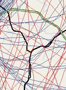
16 HMMH Report No page 12 Figure 1 Raleigh-Durham INTL Airport Diagram Source: FAA, 2008
17 HMMH Report No page 13 The second of three data sources for RDU aircraft operations was flight tracks obtained and provided from RDUAA s AirScene.com noise and operation monitoring system. These data were used directly in the modeling process as summarized in Section and categorized individual operations by operator, aircraft type and time of day (daytime or nighttime) for both departures and arrivals. HMMH associated each operation to one of the four FAA categories. The mix of engines and noise treatments varies among operators. The flight tracking data, supplemented by published sources, provided the detailed engine information needed to develop RDU-specific noise emissions for each individual operation. This procedure ensured that the efforts of operators to achieve a quieter fleet, especially for nighttime operations, would be properly represented in the noise model calculations. The third data source was RDUAA records. The NCANG has usually provided information to RDUAA on the mix of locally based military operations; however NCANG did not provide records for calendar years 2003 through 2008, but provided records for Therefore, HMMH assumed the records from 2009, prior to the NCANG March 2009 deployment, were representative of In 2008, the NCANG was considerably active in training for the March 2009 overseas deployment and the NCANG also completed phase-out of AH-64A attack helicopters, completed introduction of twenty-four AH-64D attack helicopters and added four UH-72 Lakota light utility helicopters. 15 RDUAA records provided the fleet mix for military operations by aircraft not based at RDU. HMMH combined and scaled the 2009 NCANG and 2008 RDUAA records of military aircraft to match the FAA 2008 military cumulative traffic count. Table 2 summarizes the resulting operations data for the 2008 annual average day used to model the 2008 aircraft noise exposure contours with the INM. Total operations in 2008 decreased by nine percent compared to 2007 operations. Compared to 2007, there was also a slight decrease in total night operations during 2008, resulting in a decreased number of operations that would incur the 10- db penalty applied to night ( local) operations in the computation of DNL. The total RDU aircraft operations in 2008 decreased by approximately nine percent of those in 2007 (252,708 total operations in 2007 compared to 229,406 operations in 2008). Total operations of air carrier and cargo jets decreased approximately three percent (approximately 227 average day operations in 2007 compared to 221 average day operations in 2008). Regional jets in the fifty-seat class decreased by approximately twenty-one percent (approximately 259 average day operations in 2007 compared to 217 average day operations in 2008). General aviation jet operations decreased by approximately twenty-one percent while operations of propeller aircraft as a whole (i.e. combining commercial and general aviation) decreased approximately six percent. Military operations increased approximately thirty-five percent compared to 2007 levels, which was primarily due to the aforementioned NCANG activity. The decrease in Air Carrier jet operations came from small changes in operations by a variety of aircraft types. There was an increase in operations from the Embraer 170/190 aircraft and the Boeing /400/500. However many other aircraft types decreased including (in order of net decrease in operations) the Canadair CRJ-700/900, Airbus 319, Airbus 320 and Boeing The available 2009 NCANG data was adjusted to represent calendar year The last AH-64D was delivered in March All four UH-72s were delivered in November 2008.
18 HMMH Report No page 14 Operations of hushkitted aircraft (i.e. aircraft that the FAA has recertified from 14 CFR Part 36 Stage 2 to Stage 3, based on modifications made to the aircraft or its operating certificate) decreased by approximately seventeen percent. There were approximately eleven average daily operations in 2007 and approximately nine operations in The Boeing DC-9-10/30 had the greatest reduction between 2007 and MD-80 operations decreased by about two percent from 2007 to There were approximately thirty-two MD-80 operations per day in 2007 compared to approximately thirty-one operations in Although MD-80s were originally manufactured to 14 CFR Part 36 Stage 3 certification standards, the aircraft is one of the loudest Stage 3 aircraft operating at RDU. The seat Embraer regional jets (ERJ-135 and ERJ-145) were once again the most common aircraft type to operate at RDU even though operations of this aircraft family declined by twenty-five percent (approximately one hundred seventy-six daily operations in 2007 compared to approximately one hundred thirty-two daily operations in 2008). These types have been the most common aircraft at RDU since at least The second most common aircraft type was again the Canadair 50-seat regional jets (CRJ-100 and CRJ-200) and operations by this type increased slightly from 2007 to The Canadair 50-seat regional jets have been the second most common aircraft type at RDU since approximately The seat Embraer and Canadair 50-seat regional jets combined accounted for approximately one-third of all 2008 RDU operations. 16 The MD-80 and DC-9 series were originally manufactured by McDonnell Douglas Corporation and Douglas Aircraft Company, respectively. However the Boeing Company has acquired the companies and now brands the aircraft as Boeing aircraft.
19 HMMH Report No page 15 Table 2 Annual Average Day Number of Operations 2008 DEPARTURES ARRIVALS AIRCRAFT TYPE Daytime Nighttime Daytime Nighttime Air Carrier and Air Cargo Jets (Hushkit) < < (Hushkit) (Hushkit) /400/ /800/ < < A A A A A Canadair CRJ-700/ DC <0.01 <0.01 DC-8-60 (Hushkit) DC-8-70 (Re-engine) DC-9-10/30 (Hushkit) DC-9-40/50 (Hushkit) Embraer 170/ L-1011 < < MD MD-80 Series Sub-Total Regional Jets (less than 60 seats) 2 Regional Jet (Canadair) Regional Jet (Embraer) Regional Jet (Fairchild) Sub-Total Corporate Jets Business Jets (Stage 2) Business Jets (Stage 3 / Hushkit) Business Jets (Stage 3) Sub-Total Table 2 continues on the next page.
20 HMMH Report No page 16 Table 2 Annual Average Day Number of Operations 2008, continued DEPARTURES ARRIVALS AIRCRAFT TYPE Daytime Nighttime Daytime Daytime Civilian Propeller Aircraft and Helicopters 4 Single-Engine Prop Twin-Engine Piston Prop Twin-Engine Turboprop Civilian Helicopters Sub-Total Military Aircraft Four-Engine TurboProp (C-130/P-3) Helicopters Jet Transport (C-5/C-9/C-17) Other Jets Single-Engine Turboprop Tactical (F-15/F-18/ S-3/T-37/ T-38/T-45) Twin-Engine Turboprop Sub-Total GRAND TOTALS Notes: Totals and sub-totals may not match exactly due to rounding. 1. While these aircraft are sometimes considered regional jets (and were grouped as such in the 2005 report), these aircraft are capable of carrying more than 60 passengers and therefore are counted as Air Carrier by FAA (FAA Order ). 2. These aircraft are not capable of carrying more than 60 passengers and therefore are counted as Air Taxi by FAA (FAA Order ). 3. As defined by the Code of Federal Regulations (CFR) Title 14, Part 36, Noise Standards: Aircraft Type and Airworthiness Certification 4. This category was called Commuter & General Aviation Propeller Aircraft in the 2005 report and prior reports. Source: HMMH, AirScene.com, RDUAA records
21 HMMH Report No page Runway Use In past years, HMMH developed runway use modeling assumptions in a three-step process: (1) identifying the percentage of time the traffic flow was northeast or southwest, (2) identifying the fraction of flights that used the left and right runways by flow direction and aircraft type, and (3) identifying the use of Runway 14/32. Each of these three steps involved various data and observation samples. However, RealContours processed the acceptable individual flight tracks 17 from the 2008 flight tracking data to model each operation on its associated runway. Runway use was based on actual use developed from each acceptable flight track obtained from Airscene.com Direction of Traffic Flow RDU operates its parallel runway complex in one of two directions depending on the prevailing winds. If winds are from the north, northeast or east, aircraft arrive and depart in a northeasterly direction using Runways 5L and 5R. Figure 2 depicts a one-day sample of operations on Runways 5L and 5R. If winds are from the south, southwest or west, aircraft arrive and depart to the southwest using Runways 23L and 23R. Figure 3 depicts a one-day sample of operations on Runways 23L and 23R. The complete set of flight tracking data, as prepared by RealContours, was also analyzed for direction of flow. The analysis of the modeled flight track data indicated that the runway use flow at RDU for 2008 was: Fifty-five percent southwest flow (Runways 23L and 23R) Forty-five northeast flow (Runways 5L and 5R) Table 3 provides the historical runway use modeled at RDU since The forty-five percent in northeast flow and fifty-five percent in southwest flow observed for 2008 is in the typical range recorded at RDU since RealContours uses flight tracks that meet certain criteria and have enough data for modeling. This is discussed in Section Runway use flow from prior years was documented in the various reports listed in Section 7. The runway use flow for 1992 was documented in the 1993 report.
22 HMMH Report No page 18 Table 3 Comparison of Annual Traffic Flow to 2008 Year Northeast (R/W 5) Annual Percent Flow Southwest (R/W 23) Year Average Source: HMMH, RDUAA Use of Individual Runways As mentioned previously, each of the individual 195,140 flight tracks modeled in INM had an assigned runway. The flight tracks included all six directions of RDU s three runways. The summarized runway use is presented in Table 4. All civilian helicopters are modeled as if they land and take off from Taxiways G & H. Since the flight tracking data did not include suitable data for military operations, HMMH assumed that the military aircraft had the same runway use as similar civilian aircraft types. In addition, according to NCANG personnel, military operations other than helicopters use Runways 5L/23R and 5R/23L. In the contour development for 1991 through 2005, military helicopters not based at RDU used the ramp at the NCANG base (then modeled as imaginary Runway 18/36) for arrivals and departures. The NCANG base is located near the southern end of Runway 14/32. However, recent discussions with RDUAA staff indicate that military helicopters not based at RDU (non-ncang) land and take-off from Taxiways G & H and were modeled as such for 2006 through All NCANG helicopters use the NCANG ramp. Table 4 contains the runway use percentages for 2008 for an annual average day. During calendar year 2008, Runway 5R/23L was often closed for rehabilitation between May and November (inclusive). These runway closures had the effect of reducing operations on Runway 5R/23L and increasing operations on Runway 5L/23R. In addition, on October 26, 2008 Terminal 2 opened and
23 HMMH Report No page 19 replaced Terminal C. Terminal 2 is adjacent to Runway 5L/23R and opened with a single concourse and includes 19 gates for aircraft operations. This terminal replacement had a minor effect on runway use for passenger commercial aircraft towards the end of calendar year 2008 as Delta Airlines, and regional affiliate Comair, transferred from the Terminal 1 (formerly called Terminal A), which is adjacent to Runway 5R/23L to Terminal Although many factors influence runway use, all else being equal, operators prefer to use the closest available runway to minimize taxi times. However, the use of actual flight tracking data ensures that actual runway use is modeled. 19 During the first quarter of calendar year 2008, approximately eighty percent of Delta Airlines and Comair operations used Runway 5R/23L. Delta Airlines and Comair moved to Terminal 2 on November 9, 2008 and after that time, over eight-five percent of their operations used Runway 5L/23R.
24 HMMH Report No page 20 Table 4 Runway Use Percentages for the Modeled Annual Average Day 2008 Air Carrier, Air Cargo, and Military Jet Daytime Nighttime Runway Departure Arrival Departure Arrival 5L R L R Total Regional Jet Daytime Nighttime Runway Departure Arrival Departure Arrival 5L R L R Total Corporate Jet Daytime Nighttime Runway Departure Arrival Departure Arrival 5L R L R Total Military & Commuter Propeller Daytime Nighttime Runway Departure Arrival Departure Arrival 5L R L R Total General Aviation Propeller Daytime Nighttime Runway Departure Arrival Departure Arrival 5L R L R Total Note: Totals may not match exactly due to rounding. Source: HMMH, RDUAA, AirScene.com
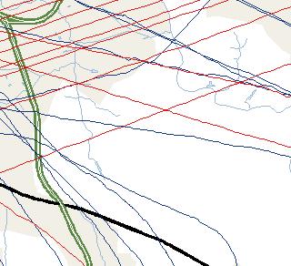
25 HMMH Report No page Flight Tracks and Flight Track Use Standard input for INM includes aircraft flight tracks developed from observation of flight operations at an airport. A group of flight tracks from aircraft using a specific runway and going to or from a single fix is referred to as a flight corridor. The width of a flight corridor generally increases with increasing distance from the airport as individual tracks become more laterally dispersed. This dispersion occurs for a variety of reasons, most of which are out of the pilot's control. Air traffic control requirements, weather and aircraft climb performance are a few of the factors involved. To model the noise exposure properly, it is important to model the dispersion properly. Several methodologies have been used to develop modeled flight tracks over the history of noise contour development at RDU and these are described in Section 2.1. For the 2008 flight tracks, RealContours prepared each of the 195,140 individual flight tracks for use in the INM, as discussed in Section The INM used the converted flight track data to produce the annual contours. The large number of individual model flight tracks, each developed from an actual recorded flight track, ensures that flight track geometry and flight corridor use is modeled as reasonably as possible for each individual airframe, engine type and time of operation (day or night with the 10 db penalty). Calendar year 2008 military aircraft operations were modeled with the representative model tracks and model track use that HMMH developed for the 2004 annual contours. Figure 2 and Figure 3 present flight tracks in Northeast flow and Southwest flow respectively. Figure 2 shows aircraft operations for May 13, 2008 and includes some departures on runway 14 and some arrivals to Runway 32. Figure 3 shows aircraft operations for November 25, 2008 and includes some arrivals to Runway 32 and some helicopters. In both figures, the runway use on the two primary runways is about the same. For example in Figure 2 there are about the same number of operations using Runway 5L as 5R. Appendix A of this report presents the 2008 procedures for jets arriving and departing RDU, which helps explain the majority of flight paths shown in Figure 2 and Figure 3.
26 HMMH Report No page 22 (This page intentionally left blank)


")

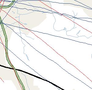
27 ST 86 ST 157 tu tu 15 Granville Prepared For: Raleigh - Durham Airport Authority Departure Flight Tracks Raleigh - Durham International Airport Arrival Flight Tracks tu 70 RDU Property RDU Buildings Orange 40 tu 501 tu 15 Durham ST 147 ST 98 ST 50 Interstate US Route Boundary Parks State Route Urban Area ST 54 ST tu 1 Water River / Stream 5L 5R 14 23L 23R 32 tu 401 Notes: Flight tracks for May 13, 2008 Includes jet and propeller aircraft operations on Runways 5L and 5R and propeller aircraft operations associated with Runway 14/32 tu 70 Wake Franklin not labeled (Northeast corner of this figure) Johnston not labeled (Southeast corner of this figure) H:\GIS\USA\NC\301254_005_RDU_2008\301254_RDU_2008_Figure02_RWY5LR_Flight_Tracks.mxd tu 15 tu 501 Chatham ST 751 tu 64 tu 1 ST 55 ST tu 64 tu tu 401 ST 50 tu ,000 16,000 24,000 32,000 Feet 2008 Flight Track Sample for Operations on Runways 5L and 5R Figure: 2 Page 23
28 HMMH Report No page 24 (This page intentionally left blank)


 Johnston not")
")
29 ST 86 ST 157 tu tu 15 Granville Prepared For: Raleigh - Durham Airport Authority Departure Flight Tracks Raleigh - Durham International Airport Arrival Flight Tracks tu 70 RDU Property RDU Buildings Orange 40 tu 501 tu 15 Durham ST 147 ST 98 ST 50 Interstate US Route Boundary Parks State Route Local Roads Urban Area Railroad ST 54 ST tu 1 Water River / Stream 5L 5R 14 23L 23R 32 tu 401 Notes: Flight tracks for November 25, 2008 Includes jet and propeller aircraft operations on Runways 23L and 23R, and propeller aircraft operations associated with Runway 14/32, and helicopter operations tu 70 Wake Franklin not labeled (Northeast corner of this figure) Johnston not labeled (Southeast corner of this figure) H:\GIS\USA\NC\301254_005_RDU_2008\301254_RDU_2008_Figure03_RWY23LR_Flight_Tracks.mxd tu 15 tu 501 Chatham ST 751 tu 64 tu 1 ST 55 ST tu 64 tu tu 401 ST 50 tu ,000 16,000 24,000 32,000 Feet 2008 Flight Track Sample for Operations on Runways 23L and 23R Figure: 3 Page 25
30 HMMH Report No page 26 (This page intentionally left blank)
31 HMMH Report No page Aircraft Altitude Profile The aircraft altitude profile is determined by many factors including the aircraft weight, engine thrust and flap settings of the aircraft and the weather conditions at the time of the aircraft operation. The INM database includes arrival and departure profiles for most aircraft within its database. The INM usually has only one arrival profile for each aircraft type and HMMH used the default arrival profile for all arrival operations. However, for a given aircraft/engine combination, departure noise is dependent on aircraft take-off weight. Since aircraft take-off weight is typically not reported by airlines, the INM has the option to assign a departure profile based on the distance of the aircraft s destination, or stage length, as a surrogate for weight. Most commercial jets and some propeller aircraft in the INM database have multiple departure weights while most general aviation aircraft, including corporate jets, only have a single weight. RealContours examined each individual flight track s altitude profile and assigned a best match from INM standard database. 20 For those military types that are based on commercial airframes, like the C-9, HMMH assigned stage lengths based on similar commercial aircraft types. 3.6 Meteorological Conditions The INM has several settings that affect aircraft performance profiles and sound propagation based on meteorological data. Meteorological settings include annual average temperature, barometric pressure, relative humidity at the airport, and average headwind speed. HMMH reviewed 2008 weather data from the National Climatic Data Center (NCDC,) for RDU (WBAN 13722). 21 Based on analysis of the NCDC data, the annual average meteorological conditions for RDU in 2008 were: temperature of 61.6 degrees Fahrenheit, sea level pressure of in-hg. and relative humidity of 65.0 percent. The headwind speed was set to the INM default of 8.0 knots. 3.7 Terrain Data Terrain data describe the elevation of the ground surrounding the airport, and on airport property. The INM, as used for the RDU 2008 contours, uses terrain data to adjust the ground level under the flight paths. The terrain data does not affect the aircraft s performance or noise levels, but does affect the vertical distance between the aircraft and a receiver on the ground. This in turn affects noise propagation assumptions in terms of the distance between the aircraft and receiver and how noise propagates over ground. The 2008 contours were developed with terrain data provided by the United States Geographic Survey (USGS) Certain limits were placed on this process. In particular, profiles were not selected if the aircraft would, according to INM, overrun the runway. 21 Data downloaded from on 1/13/ Data downloaded from on 01/29/2009 in GridFloat format.
32 HMMH Report No page 28 (This page intentionally left blank)
33 HMMH Report No page 29 4 NOISE CONTOURS For 2008, HMMH prepared three sets of Day-Night Average Sound Level (DNL) noise contours, as shown in the following four figures: Figure Annual Average Day Contours for All Operations on All Runways Figure Annual Average Day Contours Compared to 2008 Annual Average Day Contours Figure Annual Average Day Contours for All Operations on Runways 5L and 5R Figure Annual Average Day Contours for All Operations on Runways 23L and 23R Each figure presents the 55 db, 60 db, 65 db and 70 db DNL contours for each of the respective sets. The 75 db DNL contour was computed but is too small to be well depicted on these figures. The 75 db DNL contour remains within the airport boundary and does not extend more than 1050 feet from Runway 5L/23R or 700 feet from Runway 5R/23L, or 200 feet from either of the two helicopter locations in any of the contour sets. Explanations of the contours sets are provided on the pages following the figures.
34 HMMH Report No page 30 (This page intentionally left blank)
35 T S 98 t u 15 T S t u 70 T S Raleigh - Durham International Airport Pre p a r e d F o r: Ra le i g h - Du r h a m Ai rp o r t Au t h o r it y DNL Contours * * 12 * 11 *10 *9 55! ( *8 Noise Monitor Location RDU Property RDU Buildings Interstate State Route US Route Local Roads Boundary R 55 70! ( River / Stream 65! ( L 14 *1 70! ( 32 Wake 5R ty Chatham Coun Water 5L Durham Urban Area 23 *6 60! ( 23 T S Parks t u 70 T S H:\GIS\USA\NC\301254_005_RDU_2008\301254_RDU_2008_Figure04_AAD_Contours.mxd 751 William B. Umstead State Park *2 40 *4 Carl Alwin Schenck Memorial Forest T S 54 4,000 8,000 12,000 16,000 Feet 2008 Annual Average Day Contours for All Operations on All Runways Figure: 4 Page 31
36 HMMH Report No page 32 (This page intentionally left blank)
37 T S 98 t u 15 T S t u 70 T S Raleigh - Durham International Airport Pre p a r e d F o r: Ra le i g h - Du r h a m Ai rp o r t Au t h o r it y 2008 DNL Contours 2007 DNL Contours * * 12 * 11 *10 *9 RDU Property! ( 55 *8 Interstate State Route US Route Local Roads Boundary R 55 70! ( Urban Area Water River / Stream L 14 *1 70! ( 5R Wake 32 5L Durham 65! ( Parks 23 *6 60! ( 23 T S H:\GIS\USA\NC\301254_005_RDU_2008\301254_RDU_2008_Figure05_0708_AAD_Contour_Comparison.mxd RDU Buildings ty Chatham Coun Noise Monitor Location t u 70 T S 751 William B. Umstead State Park *2 40 *4 Carl Alwin Schenck Memorial Forest T S 54 4,000 8,000 12,000 16,000 Feet 2007 Annual Average Day Contours Compared to 2008 Annual Average Day Contours Figure: 5 Page 33 Railroad
38 HMMH Report No page 34 (This page intentionally left blank)
39 T S 98 t u 15 T S t u 70 T S *10 *9 55! ( Pre p a r e d F o r: Ra le i g h - Du r h a m Ai rp o r t Au t h o r it y DNL Contours * * 12 * 11 *8 Raleigh - Durham International Airport Noise Monitor Location RDU Property RDU Buildings Interstate State Route US Route Local Roads Boundary R 70! ( River / Stream 65! ( L 14 *1 70! ( 32 Wake 5R ty Chatham Coun Water 5L Durham Urban Area 23 *6 60! ( 23 T S 55 Parks t u H:\GIS\USA\NC\301254_005_RDU_2008\301254_RDU_2008_Figure06_AAD_5LR_Contours.mxd 70 T S 751 William B. Umstead State Park *2 40 *4 Carl Alwin Schenck Memorial Forest T S 54 4,000 8,000 12,000 16,000 Feet 2008 Annual Average Day Contours for All Operations on Runways 5L and 5R Figure: 6 Page 35 Railroad
40 HMMH Report No page 36 (This page intentionally left blank)
41 T S 98 t u 15 T S t u 70 T S Raleigh - Durham International Airport Pre p a r e d F o r: Ra le i g h - Du r h a m Ai rp o r t Au t h o r it y DNL Contours * * 12 * 11 *10 *9 55! ( *8 Noise Monitor Location RDU Property RDU Buildings Interstate State Route US Route Local Roads Boundary R 55 70! ( River / Stream 65! ( L 14 *1 70! ( 32 Wake 5R ty Chatham Coun Water 5L Durham 60! ( Urban Area 23 *6 23 T S Parks t u H:\GIS\USA\NC\301254_005_RDU_2008\301254_RDU_2008_Figure06_AAD_23LR_Contours.mxd 70 T S 751 William B. Umstead State Park *2 40 *4 Carl Alwin Schenck Memorial Forest T S 54 4,000 8,000 12,000 16,000 Feet 2008 Annual Average Day Contours for All Operations on Runways 23L and 23R Figure: 7 Page 37 Railroad
42 HMMH Report No page 38 (This page intentionally left blank)
43 HMMH Report No page Annual Average Day Contours for All Operations on All Runways Figure 4 presents the 55, 60, 65 and 70 db DNL contours for the annual average day in 2008, based on the annualized aircraft operations, runway use, flight track geometry and flight track use discussed in Section 3. Jet aircraft operations are the dominant source of overall exposure; propeller operations are generally quieter and have a relatively limited effect on the size and shape of the contours, except to the southeast of the airport near Runway 14/32. Helicopter operations are most pronounced at two locations on airport property, Taxiways G & H, shown as a small circle next to the Runway 14 label, and the NCANG ramp, shown as a circle in the 60 db and 65 db DNL contours near the southeast end of Runway 14/32. The elongated shape reflects the general air traffic flow in either a northeasterly or southwesterly direction. As departing aircraft proceed from the airport in either of these two directions, the ends of the contours begin to diverge into lobes that follow the principal flight corridors as they turn from the extended runway centerlines. It is also important to note that some of the lobes are dominated by arrival noise, particularly along the extended runway centerlines at the 60 db DNL and 55 db DNL contours and also at the 65 db DNL contour on the northeast side of Runway 5R/23L. The general smoothness of the contours is the result of using dispersed aircraft flight tracks in the noise modeling process, reflecting the naturally dispersed nature of flight tracks within corridors, as individual aircraft proceed onto assigned headings to their destinations. There are some subtle variations in the computed noise values as a result of terrain data. 4.2 Comparison of 2007 and 2008 Annual Average Day DNL Contours Figure 5 compares the noise contours for 2008 with those for The two contour sets have changes that are primarily associated with the Runway 5R/23L closures. The noise levels associated with Runway 5R/23L operations decreased about 1 to 2 db while noise levels associated with Runway 5L/23R operations increased about 1 db on runway centerline where arrivals dominate, but remained about the same in other areas where departures dominate. The noise levels associated with Runway 14/32 and the NCANG facility also increased about 1 to 3 db. The 2008 contours to the southeast show the shift in noise caused by the Runway 5R/23L closures. On the southeast and southern side, noise levels associated with Runway 5R arrivals and Runway 23L departures decrease on the order of 1 to 2 db between noise monitor 4 and Interstate 40. The 2008 contours have an increase of about 1 db or less along Runway 5L/23R centerline caused by the increase in Runway 5L arrivals. The increase in Runway 5L arrival noise made the db DNL contour extend further towards State Highway 55. On the northeast side of the airport, the 2008 and db and 60 db DNL have three primary lobes. The three lobes in the contours are associated with (listed from east to west) Runway 23L arrivals (noise monitors 8 and 11), Runway 23R arrivals (noise monitors 9 and northwest of 12), and finally Runway 5L and Runway 5R departures (noise monitor 10). The lobe associated with Runway 5L and Runway 5R departures extends into Durham. The Runway 23L arrival lobe decreased 1 db to 2 db in 2008 while the Runway 23R lobe increased 1 db to 2 db because of the shift in arrival operations associated with the Runway 5R/23L closures. The departure lobe shows a slight decrease in noise that is less than 1 db.
44 HMMH Report No page 40 Table 5 presents the gross land area within each of the noise contours for 2008 as well as the preceding seventeen years. 23 As the table shows, the areas within the individual contour intervals decreased slightly from 2007 to It should be noted that the 75 db DNL contours have been completely within the airport property since As discussed in Section 3.2, from 2007 to 2008 RDU experienced a nine percent decrease in the total operations. This change in overall operations is not sufficient to cause a noticeable change in the overall size of the contours. However, there were changes in operations for certain aircraft types as well as differences in runway flow and some modifications to modeling methodologies. These factors, in aggregate, resulted in an overall reduction in the contour area for any given level in the 2008 contours. The result in the 2008 contours is a four percent decrease in the total area for the 55 db DNL contour, a three percent decrease in the total area for the 60 db DNL contour, a thirteen percent decrease in the 65 db DNL contour, an approximate six percent decrease in the total area for the 70 db DNL contour. The contour area for the 75 db DNL contour increased slightly, but as noted previously, remains within the airport property Annual Average Day Contours for All Operations on Runways 5L and 5R As discussed previously, during many days of the year the traffic flow is exclusively to the northeast. When this occurs, the noise exposure pattern differs considerably from the exposure shown in Figure 4 and Figure 5. Figure 6 shows the exposure on an annual average day in northeast flow (i.e., using Runways 5L and 5R), which occurred forty-five percent of the time in Annual Average Day Contours for All Operations on Runways 23L and 23R As discussed previously, during many days of the year the traffic flow is exclusively to the southwest. When this occurs, the noise exposure pattern differs considerably from the exposure shown in Figure 4 and Figure 5. Figure 7 shows the exposure on an annual average day in southwest flow (i.e., using Runways 23L and 23R), which occurred fifty-five percent of the time in The contours of Figure 4 are the equivalent of combining Figure 6 and Figure 7 in the proportion that northeast flow and southwest flow occurred during Land area from the prior contours was documented in the various reports listed in Section 7. The area for the 1992 final contours was documented in the 1993 report.
45 HMMH Report No page 41 Table 5 Comparison of Land Use Areas within Noise Contours to 2008 Year Area Within DNL Contour (sq. mi.) 55 db DNL 60 db DNL 65 db DNL 70 db DNL 75 db DNL 1992 Final * * * * * * * Notes: Areas are cumulative; e.g., the area within the 70 db DNL contour includes the area within the 75 db contour and the area within the 55 db contour includes the area within all contour intervals. * Completely on airport property 24 Two contour sets were produced for 1992, one using the historical method of simulated flight tracks in conjunction with NOISEMAP, and a second (final) one using the method of actual, radar-recorded flight tracks in conjunction with ARTSMAP. The second (final) contour set is described in the 1993 report.
46 HMMH Report No page 42 (This page intentionally left blank)
47 HMMH Report No page 43 5 COMPARISON OF THE 2008 MODELED NOISE CONTOURS AND 2008 NOISE MEASUREMENTS The RDUAA had fixed noise monitors installed during 2008 to measure long-term cumulative noise exposure in the communities surrounding RDU. These noise monitors report their data to RDUAA s AirScene.com system. Figure 4 through Figure 7 show the monitoring locations in relation to the contours. The RDUAA provided HMMH the 2008 measurement data acquired with AirScene.com for analysis, comparison to modeled values and inclusion in this report. The permanent noise monitors began collecting data on March 31, 2008, but several of the monitors did not collect data at various times throughout the remainder of the year. Therefore, during 2008 the number of full days of noise measurements with correlated aircraft flight operations varied at each site from 182 days to 252 days. 25 The comparison between measured values to modeled values was done only for those days in which there were complete data sets from both the AirScene.com flight tracking and each respective noise monitor. Table 6 provides the measured noise levels at the noise monitors, the modeled noise levels and the difference between the modeled and measured values at each respective noise monitor location. AirScene.com reports several noise values: the total noise; community noise and aircraft noise. All three of these values are presented in Table 6. The measured total, community and aircraft DNL values were calculated from the hourly Leq values provided by AirScene.com. Airscene.com calculates the community noise levels by subtracting the aircraft-correlated noise data from the total noise measured. The columns of Table 6 are described below. a. Noise Monitor Number This is the numerical identifier for noise monitor use on Figure 4 through Figure 7 b. Noise Monitor Name The name of the noise monitor used by RDUAA staff c. Number of Measurement Days this is the number of days in which data from both the noise monitor and the flight track data were available for the complete day and were used for the purposes of this comparison. d Adjusted Aircraft Modeled DNL the average daily DNL only for the days used for the comparison (column c). The modeling results presented use a sub-set of the scaled operations discussed in Section 3. e Measured DNL, Total DNL The total DNL reported by the noise monitor for the days used for the comparison. Total DNL includes the measurement of all noise sources: aircraft, cars, dogs barking, wind in the trees, etc. f Measured DNL, Community DNL This is the DNL reported by the noise monitoring system for non-rdu aircraft correlated noise for the days used for the 25 For the purpose of this analysis, noise monitor data for a give day was only considered if the individual noise monitor reported data for at least 23 hour and 55 minutes.
48 HMMH Report No page 44 comparison. Essentially, this is the noise level of all noise not identified as RDU aircraft noise, so this value may include noise from aircraft if the system did not identify the noise as aircraft noise. g Measured DNL, Aircraft DNL This is the DNL reported by the noise monitoring system for aircraft events, identified by the monitoring system for the days used for the comparison. h. Aircraft minus Measured Aircraft DNL The difference between the adjusted modeled DNL (column d) and the measured aircraft DNL (column g). A difference of 3 to 4 db between measured and modeled levels is considered acceptable at levels below DNL 65 db. Lesser agreement would be expected at sites where modeled DNL values were less than 55 db because noise levels from non-aircraft noise sources maybe dominate and the noise monitors may not be able to distinguish aircraft noise events. The 2008 adjusted aircraft modeled DNL values were between 52 db and 62 db at all noise monitoring locations. The differences between the 2008 annual average modeled aircraft DNL values to 2008 annual average aircraft measurement DNL values ranged from 1.5 db to 7.1 db (the modeled values were higher than measured values in all cases). Three sites (2, 4 and 12) as modeled were located below DNL 55 db with a modeled to measured difference ranging between 5.5 and 7.1 db. The 2008 annual average aircraft measurement DNL values at all the sites were below 60 db and four sites were below 50 db. AirScene.com did not report aircraft noise levels for Site 6. However, site 6 is approximately 2,000 feet from Runway 5L/23R with few non-aircraft noise sources. The total noise values are 0.3 db higher than the modeled noise level for the site.
49 HMMH Report No page 45 Noise Monitor Number Table 6 Noise Monitor Name Comparison of Modeled and Measured Annual DNL Values No. of Measurement Days Adjusted Aircraft Modeled DNL 2 Total DNL (db) 2008 Measured DNL 3 Community DNL (db) Aircraft DNL (db) Modeled Aircraft minus Measured Aircraft DNL (db) (a) (b) (c) (d) (e) (f) (g) (h) 1 Triple Oak Drive Breckenridge West Regional Library Globe Road NA 4 NA 4 8 Dominion Park Harrington Grove Bethesda Fire Station Wood Valley Durham Highway Fire Station Notes 1. Comparison based on days with both flight track and at least 23 hours, 55 minutes of noise monitor data. Noise monitor data started on or about March 31, Modeled Aircraft DNL using RealContours and INM 7.0b, for the days listed in column c. 3. Measured DNL calculated from AirScene.com hourly Leq values for the days listed in column c. 4. AirScene.com did not report aircraft noise levels for noise monitor 6 / Globe Road during the sample period. Source RDUAA, HMMH, AirScene.com
50 HMMH Report No page 46 (This page intentionally left blank)
51 HMMH Report No page 47 6 SINGLE EVENT CONTOURS The DNL contours presented in Section 4 are comprised of the individual aircraft operations that occurred throughout the course of the year. This section presents the Sound Exposure Level (SEL) contours for the arrival / departure cycles of representative aircraft operating at RDU during 2007 and The SEL metric is the individual aircraft component of the DNL metric and includes both an aircraft s sound level and duration (total noise energy of the single event). In each of the figures, the aircraft is moving from left to right. On the left side the aircraft is arriving to the runway, crossing the landing threshold of the runway at the 0 on the scale. 27 The aircraft then departs from the runway to the right, starting its take-off roll at 0. The contours were prepared with conditions representative of RDU during RDUAA staff selected the fifteen aircraft presented here to represent the variety of operations at RDU. 28 Figure 8 presents Sound Exposure Levels for eight commercial aircraft along with images of the aircraft while Figure 9 presents Sound Exposure Levels for seven corporate/general aviation aircraft along with images of the aircraft. The SEL contours and the images of the aircraft are at the same respective scales in both figures. The descriptions of the various aircraft types are presented below and on the pages that follow. Airbus A The Airbus A was the most common wide-body aircraft operating at RDU in 2008 and was mostly used for cargo. Boeing with FedEx Heavyweight Hushkit The Boeing was generally used for cargo at RDU during Although the total number of operations was relatively small compared to the overall 2008 operations (Table 2), these aircraft were among the loudest aircraft that regularly operated at RDU in In addition, over half of the operations during the nighttime hours added the 10 db penalty within the DNL metric. Boeing The Boeing is also similar in noise characteristics to the and These aircraft contribute to the DNL contours because they were some of the most common aircraft to operate at RDU in 2008, as opposed to these aircraft being relatively loud. Southwest Airlines was the primary Boeing operator at RDU in Airbus A319 The Airbus A319 is the most common and smallest variant of the A320 family operating at RDU during The A320 family also includes the A320 and A321 both of which also operate at RDU and are listed in Table 2. The primary A319 operators at RDU in 2008 were Northwest Airlines and US Airways. For the 2008 noise contours, the A319 also represented operations of the Embraer 190, which made up approximately seventy-eight percent of the operations listed as Embraer 170/190 in Table The Sound Exposure Level contours presented in this Section were prepared as part of the 2007 report with INM 7.0a and calendar year 2007 metrological conditions. These contours are representative of 2008 conditions for the purpose of this Section for comparing noise from different aircraft types. 27 The aircraft is at an altitude of 50 feet as it crosses the landing threshold. 28 Ten of these aircraft appeared in the 2006 report. The contours for those ten aircraft have been updated for INM 7.0a, the most common departure profile used for 2007 (Section 0) and the 2007 weather conditions discussed in Section 3.6.


52 Technical Report on Preparation of 2008 RDU Noise Contours September 2010 HMMH Report No Figure 8 Sound Exposure Level Contours for Select Commercial Aircraft page 48

.")


53 Technical Report on Preparation of 2008 RDU Noise Contours September 2010 HMMH Report No Figure 9 page 49 Sound Exposure Level Contours for Select General Aviation Aircraft McDonnell Douglas DC-9-50 with ABS Hushkit These aircraft, like the Boeing , have been fitted with a hushkit to comply with current noise regulations in the United States (hushkitted from 14 CFR Part 36 Stage 2 to Stage 3). This aircraft represents all of the operations listed as DC-9-40/50 in Table 2. During 2008, this aircraft was used for both passenger and cargo service at RDU. McDonnell Douglas MD-82 This was the most common of the MD-80 series aircraft operating at RDU in The MD-80 series was one of the few aircraft families to have more than thirty operations per average day in 2008 and were one of the noisiest aircraft operating at the airport. This aircraft is a development of the DC-9-50 that is longer and heavier with engines that are
APPENDIX H 2022 BASELINE NOISE EXPOSURE CONTOUR
 APPENDIX H 2022 BASELINE NOISE EXPOSURE CONTOUR This appendix sets forth the detailed input data that was used to prepare noise exposure contours for 2022 Baseline conditions. H.1 DATA SOURCES AND ASSUMPTIONS
1.0 OUTLINE OF NOISE ANALYSIS...3
 Table of Contents 1.0 OUTLINE OF NOISE ANALYSIS...3 2.0 METHODOLOGY...3 2.1 BACKGROUND...3 2.2 COMPUTER MODELING...3 3.0 EXISTING NOISE ENVIRONMENT...4 3.1 EXISTING SANTA MONICA MUNICIPAL AIRPORT NOISE...4
6.C.1 AIRPORT NOISE. Noise Analysis and Land Use Impact Assessment FORT LAUDERDALE-HOLLYWOOD INTERNATIONAL AIRPORT ENVIRONMENTAL IMPACT STATEMENT
 6.C.1 AIRPORT NOISE The existing land uses are described in Chapter Five, Affected Environment. The methodologies used to develop the Geographic Information System (GIS) land use database, the estimated
APPENDIX C NOISE ANALYSIS
 APPENDIX C NOISE ANALYSIS KBE Final - 10/11/16 Existing Noise The extent of existing noise resulting from aircraft operations at Central Colorado Regional Airport (AEJ) was determined using the FAA-approved
Recommendations for Northbound Aircraft Departure Concerns over South Minneapolis
 Recommendations for Northbound Aircraft Departure Concerns over South Minneapolis March 21, 2012 Noise Oversight Committee Agenda Item #4 Minneapolis Council Member John Quincy Background Summer of 2011
Washington Dulles International Airport (IAD) Aircraft Noise Contour Map Update
 Aircraft Noise Contour Map Update") Washington Dulles International Airport (IAD) Aircraft Noise Contour Map Update Ultimate ASV, Runway Use and Flight Tracks 4th Working Group Briefing 8/13/18 Meeting Purpose Discuss Public Workshop input
Washington Dulles International Airport (IAD) Aircraft Noise Contour Map Update Ultimate ASV, Runway Use and Flight Tracks 4th Working Group Briefing 8/13/18 Meeting Purpose Discuss Public Workshop input
APPENDIX D MSP Airfield Simulation Analysis
 APPENDIX D MSP Airfield Simulation Analysis This page is left intentionally blank. MSP Airfield Simulation Analysis Technical Report Prepared by: HNTB November 2011 2020 Improvements Environmental Assessment/
Executive Summary. MASTER PLAN UPDATE Fort Collins-Loveland Municipal Airport
 Executive Summary MASTER PLAN UPDATE Fort Collins-Loveland Municipal Airport As a general aviation and commercial service airport, Fort Collins- Loveland Municipal Airport serves as an important niche
Memorandum. Federal Aviation Administration. Date: June 19, Richard Doucette, Environmental Protection Specialist. From: To:
 Federal Aviation Administration Memorandum Date: June 19, 2008 From: To: Subject: Richard Doucette, Environmental Protection Specialist LaVerne Reid, Airports Division Manager John Donnelly, Regional Counsel
Forecast of Aviation Activity
 DETROIT METROPOLITAN WAYNE COUNTY AIRPORT FAR PART 150 NOISE COMPATIBILITY STUDY UPDATE CHAPTER B FORECAST OF AVIATION ACTIVITY Forecast of Aviation Activity Introduction This chapter summarizes past aviation
Washington Dulles International Airport (IAD) Aircraft Noise Contour Map Update. Ultimate Operations 5th Working Group Briefing 9/25/18
 Aircraft Noise Contour Map Update. Ultimate Operations 5th Working Group Briefing 9/25/18") Washington Dulles International Airport (IAD) Aircraft Noise Contour Map Update Ultimate Operations 5th Working Group Briefing 9/25/18 Meeting Purpose Discuss methodology of Ultimate build scenario operations
Washington Dulles International Airport (IAD) Aircraft Noise Contour Map Update Ultimate Operations 5th Working Group Briefing 9/25/18 Meeting Purpose Discuss methodology of Ultimate build scenario operations
Runway Length Analysis Prescott Municipal Airport
 APPENDIX 2 Runway Length Analysis Prescott Municipal Airport May 11, 2009 Version 2 (draft) Table of Contents Introduction... 1-1 Section 1 Purpose & Need... 1-2 Section 2 Design Standards...1-3 Section
CHAPTER 4 DEMAND/CAPACITY ANALYSIS
 CHAPTER DEMAND/CAPACITY ANALYSIS INTRODUCTION The demand/capacity analysis examines the capability of the airfield system at Blue Grass Airport (LEX) to address existing levels of activity as well as determine
Airport Noise Management 2017 Annual Report
 Airport Noise Management 2017 Annual Report The Airport Noise Management Report provides a yearly summary of St. Louis Lambert International Airport s operations and noise complaints. The NAS (National
FORT LAUDERDALE-HOLLYWOOD INTERNATIONAL AIRPORT ENVIRONMENTAL IMPACT STATEMENT DRAFT
 D.3 RUNWAY LENGTH ANALYSIS Appendix D Purpose and Need THIS PAGE INTENTIONALLY LEFT BLANK Appendix D Purpose and Need APPENDIX D.3 AIRFIELD GEOMETRIC REQUIREMENTS This information provided in this appendix
2015 ANNUAL NOISE REPORT
 2015 ANNUAL NOISE REPORT MASSACHUSETTS PORT AUTHORITY L.G. HANSCOM FIELD BEDFORD, MA 01730 PREPARED BY AMBER GOODSPEED SUBMITTED TO HANSCOM FIELD ADVISORY COMMISSION July 2016 Connecting with our communities
Quiet Climb. 26 AERO First-Quarter 2003 January
 Quiet Climb Boeing has developed the Quiet Climb System, an automated avionics feature for quiet procedures that involve thrust cutback after takeoff. By reducing and restoring thrust automatically, the
Appendix B Ultimate Airport Capacity and Delay Simulation Modeling Analysis
 Appendix B ULTIMATE AIRPORT CAPACITY & DELAY SIMULATION MODELING ANALYSIS B TABLE OF CONTENTS EXHIBITS TABLES B.1 Introduction... 1 B.2 Simulation Modeling Assumption and Methodology... 4 B.2.1 Runway
Technical Memorandum. Synopsis. Steve Carrillo, PE. Bryan Oscarson/Carmen Au Lindgren, PE. April 3, 2018 (Revised)
") Appendix D Orange County/John Wayne Airport (JWA) General Aviation Improvement Program (GAIP) Based Aircraft Parking Capacity Analysis and General Aviation Constrained Forecasts Technical Memorandum To:
Appendix D Orange County/John Wayne Airport (JWA) General Aviation Improvement Program (GAIP) Based Aircraft Parking Capacity Analysis and General Aviation Constrained Forecasts Technical Memorandum To:
Regional Jets ,360 A319/ , , , ,780
 Excel Tab Name: Seats (18 MAP) PASSENGER AIRLINE FLIGHT SCHEDULE CALCULATION RECORD Summary 17.2 MAP flight schedule* (with Southwest Airlines B737-800s changed to B737-700s) Number of Total Seats Avg.
Fly Quiet Report. 3 rd Quarter November 27, Prepared by:
 November 27, 2017 Fly Quiet Report Prepared by: Sjohnna Knack Program Manager, Airport Noise Mitigation Planning & Environmental Affairs San Diego County Regional Airport Authority 1.0 Summary of Report
> Aircraft Noise. Bankstown Airport Master Plan 2004/05 > 96
 Bankstown Airport Master Plan 2004/05 > 96 24.1 Why Is Aircraft Noise Modelled? Modelling of the noise impact of aircraft operations has been undertaken as part of this MP. Such modelling is undertaken
Master Plan & Noise Compatibility Study Update
 Working Document-Subject to Change, March 2010 Master Plan & Noise Compatibility Study Update (14 CFR Part 150) TECHNICAL ADVISORY COMMITTEE March 24, 2010 Working Document-Subject to Change, March 2010
Developing an Aircraft Weight Database for AEDT
 17-02-01 Recommended Allocation: $250,000 ACRP Staff Comments This problem statement was also submitted last year. TRB AV030 supported the research; however, it was not recommended by the review panel,
Airport Noise Management Annual Report 2016
 Airport Noise Management Annual Report 2016 The Airport Noise Management Annual Report is a publication of the Airport Noise Management Office. This report provides an annual summary of Lambert- Louis
WELCOME! FORT LAUDERDALE-HOLLYWOOD INTERNATIONAL AIRPORT 14 CFR PART 150 NOISE AND LAND USE COMPATIBILITY STUDY
 WELCOME! FORT LAUDERDALE-HOLLYWOOD INTERNATIONAL AIRPORT 14 CFR PART 150 NOISE AND LAND USE COMPATIBILITY STUDY Public Information Workshop November 2017 1 14 CFR Part 150 Overview Establishes the methodology
Airport Noise Management Report 3rd Quarter 2017
 Airport Noise Management Report 3rd Quarter 2017 The Airport Noise Management Report provides the 3rd quarter 2017 summary of St. Louis Lambert International Airport s operations and noise complaints.
Airport Noise Management Report 1st Quarter 2017
 Airport Noise Management Report The Airport Noise Management Report is a publication of the Airport Noise Management Office. This report provides a 1st quarter summary of St. Louis Lambert International
Portland International Jetport Part 150 Noise Committee Meeting 2 April 4, :00PM Portland Jetport Conference Room. Agenda
 Portland International Jetport Part 150 Noise Committee Meeting 2 April 4, 2002 6:00PM Portland Jetport Conference Room Agenda Time: Location: 6 p.m. Portland International Jetport Conference Room I. Administration
Portable Noise Monitor Report
 Portable Noise Monitor Report Chicago O Hare International Airport Site 2117 5843 N. Christiana Avenue, Chicago July 14, 217 through August 2, 217 USH5-ILH15-ILS8-CHI39 Visit the O Hare Noise webpage on
FRENCH VALLEY AIRPORT (F70) Sky Canyon Dr. Murrieta, CA. Phone: Riverside FAA FSDO Complaint Line: (951)
 Sky Canyon Dr. Murrieta, CA. Phone: Riverside FAA FSDO Complaint Line: (951)") FRENCH VALLEY AIRPORT (F70) 37600 Sky Canyon Dr. Murrieta, CA Phone: 951-600-7297 Riverside FAA FSDO Complaint Line: (951) 276-6701 Visit the F70 website for additional information regarding the airport
FRENCH VALLEY AIRPORT (F70) 37600 Sky Canyon Dr. Murrieta, CA Phone: 951-600-7297 Riverside FAA FSDO Complaint Line: (951) 276-6701 Visit the F70 website for additional information regarding the airport
Draft Concept Alternatives Analysis for the Inaugural Airport Program September 2005
 Draft Concept Alternatives Analysis for the Inaugural Airport Program September 2005 Section 3 - Refinement of the Ultimate Airfield Concept Using the Base Concept identified in Section 2, IDOT re-examined
Airport Noise Management Report
 Airport Noise Management Report The Airport Noise Management Report is a publication of the Airport Noise Management Office. ANNU AL R EPORT Y E AR 201 4 N O I S E C O M P L A I N T S There were 51 noise
Time-series methodologies Market share methodologies Socioeconomic methodologies
 This Chapter features aviation activity forecasts for the Asheville Regional Airport (Airport) over a next 20- year planning horizon. Aviation demand forecasts are an important step in the master planning
Technical Report. Aircraft Overflight and Noise Analysis. Brisbane, California. December Prepared by:
 Aircraft Noise Abatement Office Technical Report Aircraft Overflight and Noise Analysis Brisbane, California Prepared by: P.O. Box 8097 San Francisco, California 94128 (650) 821-5100 Introduction In response
Portable Noise Monitor Report
 Portable Noise Monitor Report Chicago O Hare International Airport Site 2198 5N67 Rochefort Lane, Wayne May 9, 218 through June 3, 218 USH6-ILH49-ILS25 Visit the O Hare Noise webpage on the Internet at
Massport and FAA RNAV Pilot Study Overview Briefing to Massport CAC. December 8, 2016
 Massport and FAA RNAV Pilot Study Overview Briefing to Massport CAC December 8, 2016 Contents FAA/Massport RNAV MOU Context Boston Logan Context FAA RNAV MOU, Overview Q&A 12/8/2016 2 FAA/Massport RNAV
Buchanan Field. Airport Planning Program. FAR Part 150 Meeting. September 28, Master Plan FAR Part 150 Noise Study Strategic Business Plan
 Airport Planning Program Master Plan FAR Part 150 ise Study Strategic Business Plan FAR Part 150 Meeting September 28, 2006 Agenda Introduction Part 150 Study Working Paper Two Operational Alternatives
Portable Noise Monitor Report
 Portable Noise Monitor Report Chicago O Hare International Airport Site 213 475 W. Hutchinson Street, Chicago April 8, 217 through May 3, 217 USH5-ILH19-ILS1-CHI45 Visit the O Hare Noise webpage on the
Airport Noise Management Report 2nd Quarter 2016
 Airport Noise Management Report 2nd Quarter 2016 The Airport Noise Management Report is a publication of the Airport Noise Management Office. This report provides a 2nd quarter summary of St. Louis Lambert
Noise Oversight Committee
 Noise Oversight Committee July 22, 2015 Audio recordings are made of this meeting 1 Noise Oversight Committee July 22, 2015 Item 1 Review and Approve Draft Meeting Minutes Minutes from May 20, 2015 Noise
Document prepared by MnDOT Office of Aeronautics and HNTB Corporation. MINNESOTA GO STATE AVIATION SYSTEM PLAN
 LAST UPDATE JULY 2013 Acknowledgements The preparation of this document was financed in part by a grant from the Federal Aviation Administration (Project No: 3-27-0000-07-10), with the financial support
Noise Abatement 101. July 13, Regular Board Meeting / August 7, 2014 Hillsborough County Aviation Authority
 Noise Abatement 101 July 13, 2017 1 Objectives Provide context and a better understanding for how and why flights may operate at Tampa International Airport the way they do. Provide an overview of laws,
PUBLIC INFORMATION WORKSHOP #4 / PUBLIC HEARING November 8 / 9, 2006
 PUBLIC INFORMATION WORKSHOP #4 / PUBLIC HEARING November 8 / 9, 2006 A Noise Compatibility Study, prepared under Part 150 of the Federal Aviation Regulations (FAR), is a voluntary program aimed at balancing
APPENDIX X: RUNWAY LENGTH ANALYSIS
 APPENDIX X: RUNWAY LENGTH ANALYSIS Purpose For this Airport Master Plan study, the FAA has requested a runway length analysis to be completed to current FAA AC 150/5325-4B, Runway Length Requirements for
STAFF REPORT. Airport Land Use Plan Consistency Review: Santa Barbara Airport Master Plan. MEETING DATE: November 19, 2015 AGENDA ITEM: 7D
 STAFF REPORT SUBJECT: Airport Land Use Plan Consistency Review: Santa Barbara Airport Master Plan MEETING DATE: AGENDA ITEM: 7D STAFF CONTACT: Peter Imhof, Andrew Orfila RECOMMENDATION: Adopt findings
Permanent Noise Monitoring Act Quarterly Operations Report
 Permanent Noise Monitoring Act 1st Quarter 2006 Prepared by: Noise Mitigation Programs Office Rhode Island Airport Corporation For further information, please contact: Helena S. Reid, 737-4000 ext. 297
Portable Noise Monitor Report
 Portable Noise Monitor Report Chicago O Hare International Airport Site 241 61 Grange Road, Elk Grove Village October 3, 215 through October 19, 215 USH8-ILH55-ILS28 Visit the O Hare Noise webpage on the
Permanent Noise Monitoring Act Quarterly Operations Report
 Permanent Noise Monitoring Act Prepared by: For further information, please contact: Daniel Porter at 401-691-2419. TABLE OF CONTENTS Introduction...3 Permanent Noise Monitoring Act...3 Passenger Activity...4
FUTENMA REPLACEMENT FACILITY BILATERAL EXPERTS STUDY GROUP REPORT. August 31, 2010
 FUTENMA REPLACEMENT FACILITY BILATERAL EXPERTS STUDY GROUP REPORT August 31, 2010 MANDATE AND SCOPE OF WORK: In order to achieve the earliest possible relocation of Marine Corps Air Station Futenma, the
Appendix 5 Supplemental Noise and Aircraft Substitution
 Appendix 5 Supplemental Noise and Aircraft Substitution Appendix Integrated Noise Model Substitutions Summary The FAA s Integrated Noise Model (INM), Version 7.d, was used to generate aircraft noise exposure
CATCODE ] CATCODE
![CATCODE ] CATCODE](/thumbs/82/85644630.jpg "CATCODE ] CATCODE") Runways. FAC: 1111 CATCODE: 111111 OPR: AFCEC/COS OCR: AF/A3O-A 1.1. Description. The runway is the paved surface provided for normal aircraft landings and take offs. Runways are classified as either Class
Runways. FAC: 1111 CATCODE: 111111 OPR: AFCEC/COS OCR: AF/A3O-A 1.1. Description. The runway is the paved surface provided for normal aircraft landings and take offs. Runways are classified as either Class
Noise Exposure
 4-1 4. FAR Part 150 guidelines require the evaluation of a five-year future forecast condition in the analysis of noise exposure at an airport. This section documents the expected future operating conditions
LAX Community Noise Roundtable. Aircraft Noise 101. November 12, 2014
 LAX Community Noise Roundtable Aircraft Noise 101 November 12, 2014 Overview Roles and Responsibilities for Aircraft Noise Relevant Federal Regulations Relevant California Regulations Aircraft Noise Metrics
CHAPTER 6 NOISE EXPOSURE
 CHAPTER 6 NOISE EXPOSURE FAA requires that the NEM submitted for review represent the aircraft noise exposure for the year of submittal (in this case 2008) and for a future year (2013 for OSUA). However,
3. Aviation Activity Forecasts
 3. Aviation Activity Forecasts This section presents forecasts of aviation activity for the Airport through 2029. Forecasts were developed for enplaned passengers, air carrier and regional/commuter airline
Number of Complaints by Community 2015
 Airport Noise Management Annual Report 2015 The Airport Noise Management Report is a publication of the Airport Noise Management Office. This report provides an annual summary of Lambert St. Louis International
CHAPTER 1 INTRODUCTION AND BACKGROUND
 CHAPTER 1 INTRODUCTION AND BACKGROUND An Environmental Assessment (EA) evaluates the effects of a proposed Federal action on the surrounding environment and is prepared in compliance with the National
Portable Noise Monitor Report
 Portable Noise Monitor Report Chicago O Hare International Airport Site 2114 5516 N. Neenah Avenue, Chicago July 12, 217 through August 9, 217 USH5-ILH19-ILS1-CHI45 Visit the O Hare Noise webpage on the
Portable Noise Monitor Report
 Portable Noise Monitor Report Chicago O Hare International Airport Site 299 93 Wilshire Avenue, Elk Grove Village June 27, 217 through July 1, 217 USH8-ILH55-ILS28 Visit the O Hare Noise webpage on the
TORONTO PEARSON INTERNATIONAL AIRPORT NOISE MANAGEMENT
 TORONTO PEARSON INTERNATIONAL AIRPORT NOISE MANAGEMENT Noise and the GTAA The GTAA is sensitive to the issue of aircraft noise and how it affects our neighbours. Since assuming responsibility for Toronto
Permanent Noise Monitoring Act Quarterly Operations Report
 Permanent Noise Monitoring Act Quarterly Operations Report 1st Quarter 2010 Prepared by: Noise Mitigation Programs Office Rhode Island Airport Corporation For further information, please contact: Helena
Part 150 Committee April 24, 2008
 Part 150 Committee April 24, 2008 Part 150 Committee Aircraft Operations Inputs Flight Track and Runway Use Inputs DNL Contour Results SEL Contours Noise Measurement Results Public Comment and Questions
ENVIRONMENTAL EVALUATION (Written Re-Evaluation) for AIRPORT DEVELOPMENT PROJECTS
 for AIRPORT DEVELOPMENT PROJECTS") ENVIRONMENTAL EVALUATION (Written Re-Evaluation) for AIRPORT DEVELOPMENT PROJECTS FEDERAL AVIATION ADMINISTRATION MEMPHIS AIRPORTS DISTRICT OFFICE-SOUTHERN REGION AIRPORTS DIVISION Airport: Piedmont Triad
ENVIRONMENTAL EVALUATION (Written Re-Evaluation) for AIRPORT DEVELOPMENT PROJECTS FEDERAL AVIATION ADMINISTRATION MEMPHIS AIRPORTS DISTRICT OFFICE-SOUTHERN REGION AIRPORTS DIVISION Airport: Piedmont Triad
Airport Noise Management System Chicago Midway International Airport
 2 nd Quarter 2018 Quarterly Report Airport Noise Management System Visit the Midway Noise webpage on the Internet at www.flychicago.com/midwaynoise Airport Noise Management System Quarterly Report Report
Airport Noise Management System Chicago Midway International Airport
 1 st Quarter 2018 Quarterly Report Airport Noise Management System Midway International Airport Visit the Midway Noise webpage on the Internet at www.flychicago.com/midwaynoise Airport Noise Management
Cairns Airport Aircraft Noise Information Report
 Cairns Airport Aircraft Noise Information Report Quarter 4 2015 (October to December) 1 Version Control Version Number Detail Prepared by Date 1 - Environment February 2016 Airservices Australia. All rights
Airport Noise Management System
 4 th Quarter 2009 Quarterly Report Airport Noise Management System City of Chicago Department of Aviation Visit the Community Noise Resource Center on the Internet at www.flychicago.com Airport Noise Management
1. Introduction. 2.2 Surface Movement Radar Data. 2.3 Determining Spot from Radar Data. 2. Data Sources and Processing. 2.1 SMAP and ODAP Data
 1. Introduction The Electronic Navigation Research Institute (ENRI) is analysing surface movements at Tokyo International (Haneda) airport to create a simulation model that will be used to explore ways
Massport and FAA RNAV Pilot Study Overview Public Briefing. February 22, 2017 State Transportation Bld. Boston, MA
 Massport and FAA RNAV Pilot Study Overview Public Briefing February 22, 2017 State Transportation Bld. Boston, MA As of 02/10/2017 Agenda Welcoming Remarks Tom Glynn (Massport CEO) David Carlon (Massport
NOISE COMPLAINT HOTLINE
 206 ANNUAL NOISE COMPLAINT HOTLINE REPORT Introduction The Columbus Regional Airport Authority (CRAA) owns and operates John Glenn Columbus International (CMH), Rickenbacker International (LCK) and Bolton
Airport Noise Management System Chicago Midway International Airport
 4 th Quarter 2018 Quarterly Report Airport Noise Management System Visit the Midway Noise webpage on the Internet at www.flychicago.com/midwaynoise Airport Noise Management System Quarterly Report Report
Documentation of the Elevation Selected to Model Helicopter Noise at HTO
 Documentation of the Elevation Selected to Model Helicopter Noise at HTO The elevation of helicopters 4 miles from HTO airport varies greatly, from 200 feet to more than 3,000 feet. When modeling the noise
St. Paul Downtown Airport (STP)
") Reliever Airports: NOISE ABATEMENT PLAN St. Paul Downtown Airport (STP) 1 INTRODUCTION The noise abatement plan for the St. Paul Downtown Airport (STP) was prepared in recognition of the need to make the
Reliever Airports: NOISE ABATEMENT PLAN St. Paul Downtown Airport (STP) 1 INTRODUCTION The noise abatement plan for the St. Paul Downtown Airport (STP) was prepared in recognition of the need to make the
Draft Concept Alternatives Analysis for the Inaugural Airport Program September 2005
 Draft Concept Alternatives Analysis for the Inaugural Airport Program September 2005 Section 1 - Introduction This report describes the development and analysis of concept alternatives that would accommodate
Airport Noise Management System Chicago Midway International Airport
 3 rd Quarter 2018 Quarterly Report Airport Noise Management System Visit the Midway Noise webpage on the Internet at www.flychicago.com/midwaynoise Airport Noise Management System Quarterly Report Report
The purpose of this Demand/Capacity. The airfield configuration for SPG. Methods for determining airport AIRPORT DEMAND CAPACITY. Runway Configuration
 Chapter 4 Page 65 AIRPORT DEMAND CAPACITY The purpose of this Demand/Capacity Analysis is to examine the capability of the Albert Whitted Airport (SPG) to meet the needs of its users. In doing so, this
The following criteria shall be applied within the boundaries of the AO District:
 Sec. 419 (a) Purpose AIRPORT OVERLAY DISTRICT (AO) The purpose of the Airport Overlay District is to regulate and restrict the height of structures, objects, or natural growth, regulate the locations of
Cairns Airport Aircraft Noise Information Report. Quarter (July to September)
") Cairns Airport Aircraft Noise Information Report Quarter 3 2012 (July to September) 1 Version Control Version Number Detail Prepared by Date 1 - Environment 19 December 2012 Airservices Australia. All
Cairns Airport Aircraft Noise Information Report Quarter 3 2012 (July to September) 1 Version Control Version Number Detail Prepared by Date 1 - Environment 19 December 2012 Airservices Australia. All
Minneapolis-St. Paul International Airport (MSP)
") 2 nd Quarter 2016 Minneapolis-St. Paul International Airport (MSP) Public Input Meeting Metropolitan Airports Commission Noise Program Office April 27, 2016 PUBLIC INPUT MEETING Meeting Goals To hear the
2 nd Quarter 2016 Minneapolis-St. Paul International Airport (MSP) Public Input Meeting Metropolitan Airports Commission Noise Program Office April 27, 2016 PUBLIC INPUT MEETING Meeting Goals To hear the
Welcome to Public Information Workshop 1. San Francisco International Airport FAR Part 150 Study Update Noise Exposure Map Report
 Welcome to Public Information Workshop 1 Chetcuti Room, City of Milbrae 450 Poplar Avenue Milbrae, California 94030 Wednesday, June 4, 2014 5:45 p.m. to 6:45 p.m. PDT The FAA typically uses the airport
Boise Airport 14 CFR Part 150 Study Update
 Boise Airport 14 CFR Part 150 Study Update Updated Noise Exposure Maps and Noise Compatibility Program Prepared for: CITY OF BOISE Prepared by: HNTB Corporation CSHQA Wyle Laboratories Synergy Consulting
14 CFR PART 150 NOISE AND LAND USE COMPATIBILITY STUDY
 14 CFR PART 150 NOISE AND LAND USE COMPATIBILITY STUDY Technical Committee Meeting #3 March 7, 2018 1 Agenda Introductions Review of the Role of the TC Meeting Facilitator Review of Prior TC Meetings Public
The forecasts evaluated in this appendix are prepared for based aircraft, general aviation, military and overall activity.
 Chapter 3: Forecast Introduction Forecasting provides an airport with a general idea of the magnitude of growth, as well as fluctuations in activity anticipated, over a 20-year forecast period. Forecasting
Public Information Meeting
 CLT Noise Exposure Map Update Public Information Meeting February 5, 2015 1 Welcome and Introductions Charlotte Douglas International Airport Sponsor of the Noise Exposure Map (NEM) Update Certify the
Airport Noise Management System Chicago O Hare International Airport
 November 218 Monthly Report Airport Noise Management System Chicago O Hare International Airport Visit the O Hare Noise webpage on the Internet at www.flychicago.com/ordnoise Airport Noise Management System
Portable Noise Monitor Report
 Portable Noise Monitor Report Chicago O Hare International Airport Site 221 5716 N. Virginia Avenue, Chicago July 23, 214 through August 11, 214 Visit the O Hare Noise Management Webpage on the Internet
Norman Y. Mineta San Jose International Airport Annual Noise Report
 Norman Y. Mineta San Jose International Airport 2015 Annual Noise Report Annual Noise Report for Norman Y. Mineta San José International Airport Introduction and Purpose The purpose of this annual report
Airport Noise Management Report 1st Quarter 2018
 AIRPORT NOISE MANAGEMENT REPORT 1 ST QUARTER 2018 The Airport Noise Management Report provides the summary of St. Louis Lambert International Airport s operations and noise complaints. The data in this
Airport Noise Management Report 1st Quarter 2018
 AIRPORT NOISE MANAGEMENT REPORT 2 nd QUARTER 2018 Airport Noise Management Report 1st Quarter 2018 The Airport Noise Management Report provides the 2nd Quarter 2018 summary of St. Louis Lambert International
Overview of Boston Logan Operations and Noise from Overflights. Presentation to Massport Board March 19, 2015
 Overview of Boston Logan Operations and Noise from Overflights Presentation to Massport Board March 19, 2015 Contents How the Airport Operates Massport s Noise Abatement Program for Logan Recent Trends
2009 Muskoka Airport Economic Impact Study
 2009 Muskoka Airport Economic Impact Study November 4, 2009 Prepared by The District of Muskoka Planning and Economic Development Department BACKGROUND The Muskoka Airport is situated at the north end
QUARTERLY NOISE REPORT For: California Department of Transportation
 QUARTERLY NOISE REPORT For: California Department of Transportation 1st Quarter 2015 January 1 March 31, 2015 Airport Noise Mitigation June 12, 2015 TABLE OF CONTENTS Summary of Statistical Information
RTIA Runway Utilization Discussion Paper
 RTIA Runway Utilization Discussion Paper December 2003 1.0 Introduction The Airport Noise Advisory Panel (ANAP) is a voluntary committee formed by the Airport Authority of Washoe County (AAWC) Board of
Airport Noise Management System Chicago Midway International Airport
 4 th Quarter 2017 Quarterly Report Airport Noise Management System Visit the Midway Noise webpage on the Internet at www.flychicago.com/midwaynoise Airport Noise Management System Quarterly Report Report
NOISE AND FLIGHT PATH MONITORING SYSTEM BRISBANE QUARTERLY REPORT JULY - SEPTEMBER 2011
 NOISE AND FLIGHT PATH MONITORING SYSTEM BRISBANE QUARTERLY REPORT JULY - SEPTEMBER 211 Date Version Comments Page 2 Foreword Airservices Australia has established a Noise and Flight Path Monitoring System
AIRSERVICES AUSTRALI A
 AIRSERVICES AUSTRALI A NOISE AND FLIGHT PATH MONITORING SYSTEM BRISBANE QUARTERLY REPORT APRIL - JUNE 211 Date Version Comments Page 2 Foreword Airservices Australia has established a Noise and Flight
Airport Noise Management System Chicago O Hare International Airport
 March 218 Monthly Report Airport Noise Management System Chicago O Hare International Airport Visit the O Hare Noise webpage on the Internet at www.flychicago.com/ordnoise Airport Noise Management System
Van Nuys Airport December 2011 Updated 14 C.F.R. Part 150 Noise Exposure Maps page 1
 Updated 14 C.F.R. Part 150 Noise Exposure Maps page 1 1 INTRODUCTION The federal Airport Safety and Noise Abatement Act of 1979 1 ( ASNA ), as amended, defines procedures under which the federal government,
NOISE AND FLIGHT PATH MONITORING SYSTEM BRISBANE QUARTERLY REPORT OCTOBER - DECEMBER 2013
 NOISE AND FLIGHT PATH MONITORING SYSTEM BRISBANE QUARTERLY REPORT OCTOBER - DECEMBER 213 Date Version Comments Page 2 Foreword Airservices Australia has established a Noise and Flight Path Monitoring System