ALASKA This document is a summary of what McCarthy/Kennicott area offers.
|
|
|
- Julius Williamson
- 5 years ago
- Views:
Transcription
1 ALASKA 2018 The Alaska Trip in July 2018 is loosely built around two sites. The first is the Wrangell-St Elias National Park. The second is Valdez and the nearby glacier which we plan to visit. We expect to spend the bulk of our time in the National Park. You can do a lot of research online but this document will give you a feel for what your options are. This is a very unstructured trip we are planning it this way so those who wish to walk/trek/climb can do that, while those who would like to be in a wilderness area but be more sedentary can come and enjoys the outdoors as well. This document is a summary of what McCarthy/Kennicott area offers. Introduction to Wrangell St. Elias National Park Wrangell St. Elias National Park is the largest in the United States - by far. One frequently quoted statistic is that it's 6 times the size of Yellowstone National Park. Here are few more comparisons to give you a frame of reference. o Glacier Nat. Park - 1 million acres o Yellowstone million acres o State of Maryland million acres o Switzerland (yes the country) 10.2 million acres o Wrangell St. Elias National Park million acres You get the idea - this is a really big place. Just across the Canadian border are Kluane National Park Reserve and Tatshenshini-Alsek National Park. The entire region composed of all three parks has been designated a World Heritage site and at 24.3 million acres comprises the largest internationally protected chunk of real estate on the planet. You could spend a lifetime exploring this park so you had better get started. Getting to Wrangell St. Elias National Park takes a bit of doing. It's about an 8 hour drive from Anchorage and the last 96km is a gravel road from Chitina to McCarthy. But that remoteness is what Wrangell-St. Elias is all about. Denali has become so heavily visited that it became necessary to institute a permit system to protect the backcountry from overuse. As a result, trekkers can't make plans in advance but are at the mercy of whatever sectors of the backcountry are available when they show up at park headquarters. Wrangell St. Elias National Park doesn't suffer from that problem. The lighter usage combined with stunning terrain make this the Wrangell St. Elias National Park the ultimate destination for those seeking an epic experience with truly remote wilderness.
, while the historic town of Kennicott is more touristy and national")
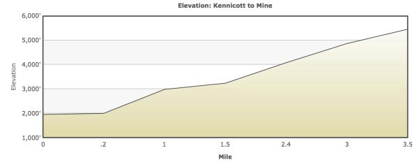
2 Around McCarthy We will be based out of the town of McCarthy. Here s a view down the main street. Photography McCarthy itself is a "funky" sort of place (old-time Alaska, lots of old junk, odd people/buildings, "new-agey"), while the historic town of Kennicott is more touristy and national park-like. There is enormous scope for the camera to be pointed in all sorts of interesting places. If all you did was spend your time here with the camera it would be unique time, well spent. The NPS provides a wide range of free public tours that typically last minutes and don't require too much walking. These include walks down Main Street, where you'll learn about each building and hear what life was like during the town's heyday. You also might

3 find yourself with a naturalist, who will take you a little ways outside of town to identify local native plants, trees, and flowers. Check in at the kiosk or visitor center. The iconic view in Kennicott is the giant red mill building from the old Kennecott Copper Company, which stands 14 stories above the Kennicott glacier (the different spellings are due to clerical mistakes on official paperwork a century ago). You need a guide to explore inside the actual building. There are numerous other buildings and sites which can be explored. Adventure Activities These will cost extra. Activities such as Kennicott Wilderness Guides Packrafting Tours if five of us do this the cost will be USD130 per person. This new sport was born in Alaska. It incorporates a lightweight, inflatable, personal raft, paddle and drysuit and allows unprecedented access to the wilderness of Alaska.
4 Now you can learn to packraft with Kennicott Wilderness Guides in one of the most unique places on the planet! This is a full day of adventure, crafted to teach the basic skills of packrafting and then have fun with those skills. You ll begin with the boats packed on your backs (they re under 9 pounds and can fit in a day bag) as you take an interpretative walk along a lake that marks the end of a 43km glacier. Then, you ll get into the boats in this lake with views of a 7,000-foot icefall, paddle around amidst icebergs, and learn to use these unique boats in Class I II water with the possibilities of running some class III rapids. Or You can choose between two day trips, appropriate for anyone ages 8 to 75 or older (Prices vary from USD95.00 to USD130 per activity). 4-Hour Kennicott Glacial Lake Inflatable Tour: This relaxing, four-hour tour focuses on a novel segment of nature literally. This lake has only formed in the past 20 years or so, so its scenery is constantly changing but you can count on seeing plenty of icebergs in the lake. The trip includes the use of either an inflatable Kayak or Stand Up Paddle Board: you ll paddle around, learn about history of the area, and talk about glaciation, as well as learn about life in McCarthy. Experience the ever changing scenery of Kennicott Glacier Lake 4-Hour Kennicott Glacier Lake & River Rafts: This tour is also four hours, spending time on Kennicott Glacial Lake. But you also get some thrills during an hour-long stretch on the Kennicott River, a wide, high-volume glacial river. You ll start with class-3 rapids (expect to get wet) and then go on a stretch of relaxing class 2, giving you time to check out the glacier shoreline, Chugach and Wrangell mountains. As Nik would say, if this trip had a soundtrack, the first half would be John Denver (as in Rocky Mountain High ) and the second half, Black Sabbath. Calm Waters, Sunny Skies Beginners will like that, in the lake-plus-river trip, you get some lake time to get used to the boat before the thrill ride begins. But in general, if you want a gentle ride, take your tour in the morning, when the water is at is calmest, and the sun reflects nicely off the water (afternoons, meanwhile, get points for a few more thrills, and being a little warmer). Otherwise, Nik tells customers to dress in layers (nothing too bulky), bring a water bottle, and come about 15 minutes early to get fitted with a dry suit, helmet, flotation device, and river shoes, before you get shuttled down to the lake. And so on and so on. Heaps to do, or simply put your feet up with a good book.

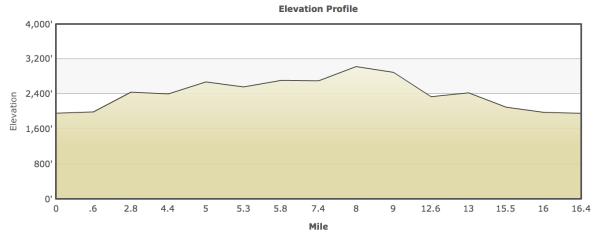
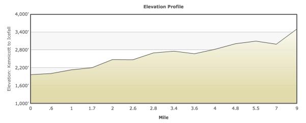
5 Activities Around McCarthy Day Hikes Erie Mine Bunkhouse A strenuous and sometimes challenging hike up to the Erie Mine bunkhouse on Bonanza Ridge. Can be done as a day hike or with a night at the campsite at the edge of the moraine. Great glacier views. Distance 16km out and back (same as Cowan track) Access Trail begins on the road north out of Kennicott Difficulty Very strenuous Map USGS McCarthy B-5, C-6 Approx Hiking Time 5-7 hours Challenges Very steep and at times exposed

6 Gain/Loss /-2847 Best Season Aug- Sept terrain, requires route finding The Hike (From Hiking Alaska s Wrangell-St Elias National Park and Preserve, by Greg Fensterman) Head north out of Kennicott on the dirt road that becomes the Root Glacier Trail. At about 800m a signed junction indicates the Root Glacier Trail to the left and Jumbo and Bonanza Mines to the right. Take the glacier trail to the left. About 100 yards beyond, cross Bonanza Creek on the small foot bridge. Cross Jumbo Creek at about 2.0km on a log bridge. Be careful, as the logs can be slippery when wet. The next stream crossing is Amazon, which is about 800m from Jumbo. About 320m from Amazon Creek (WP15) is a sign marked G L A C I E R, just in case you were wondering what the big sheet of ice was all about. It indicates the trail the descends to the Root Glacier. Don t take that, but remain on the trail and continue along the way you have been travelling. A bit further down the trail is an outhouse on the right. Additional campsites and food storage containers are located on the left and down about 40 feet. Beyond the cut-off to the Root Glacier you leave the hustle and bustle of campsites, outhouses and trail junctions behind. Most folks heading out this way are bound for the glacier, so beyond the cut-off the trail becomes more lightly travelled. Its therefore narrower and more bushed in, but still an easy trail. Keep an eye out for bears and make noise as you hike through the brush. Bears are very common all along the glacier trail. Though much of this section of the trail is in the brush, there are occasional breaks that

7 offer views of Donoho Peak, Root Glacier, Fireweed Mountain and more, if the skies are clear. At 4.1km is an unnamed stream the last stream crossing and your last opportunity for water. It s been an easy walk so far, but stoke up on water because things are about to get a bit more strenuous. The views open up beyond this point, and if it s not too cloudy you can see Mount Blackburn as well as the Chugach Range back in the other direction. A large rockslide partially covers the trail around 4.8km, but just keep going it re-emerges on the other side. Just past 6.4km at WP32 is a large gully that leads steeply up and up. This is the route to the bunkhouse. To confirm this is the correct gully look for the green metal food storage bin near the trail. If you get to the gully where the tram cable is located, you have gone a gully too far. But it s worthwhile to make this short hike to the tram cable just to check it out. The season for this hike is listed as best for August and later because snow often fills the gully until midsummer. If you do the hike in early summer its possible and actually easier to ascend on the snow than on the rock, and scree that is exposed later. But if you attempt to hike up on snow you should have an ice axe and the skills to execute a self-arrest. The snow by June will be well consolidated and quite hard-packed. A slide on such snow might be difficult to arrest. The snow is often filled with rock higher up, make an uncontrolled slide more hazardous. A pair of crampons wouldn t be a bad idea, as well as boots with a sole stiff enough to allow edging on hard snow. The angle might not seem so bad down below but
8 the slope gets steeper and steeper as you climb. Remember also that descending is always more difficult than ascending on steep, hard snow. The route is clear, however just head straight up the gully. As you climb you will pass two side gullies off to the left that seem to offer a more direct route to your destination. The second gully is a possible route but it involves exposed bouldering moves and should be considered an advanced option. Best to stick to the main route. The gully narrows and steepens towards the top then turns into a grassy slope. Continue on up the trail in the grass, which can be steep at times. Hike up and over the first rock outcropping. This is a good vantage for some photos of the bunkhouse with a backdrop of the icefall in the distance. Just above the rock outcropping, drop down to your left (north) into the gully by traversing across the ridge. Take the grassy slope to the top of the ridge on your left, being sure to go all the way to the top of the slope where you will be able to see the bunkhouse. In 2004 the bunkhouse roof collapsed under heavy snow load, so the structure is not deteriorating much faster. Enter the structure at your own risk and use caution. Resist the temptation to freelance your route back down and return the way you came.
 Park Service Information Station Difficulty Very strenuous, Map USGS McCarthy, C-6 advanced Approx Hiking Time 10-12 hours Challenges")
9 Fireweed Mountain A very challenging and strenuous scramble up the guardian of McCarthy. Great views of the entire area from the summit. Distance 18km out and back Access McCarthy Road Mile 59, (95km) Park Service Information Station Difficulty Very strenuous, Map USGS McCarthy, C-6 advanced Approx Hiking Time hours Challenges Route finding, very Gain/Loss +5,500 steep slopes, scree, Best Season June- Sept brush, possible exposure. This is one of the more demanding day hikes available out of McCarthy and

10 involves serious route finding and bushwhacking to reach the summit. The Hike Fireweed Mountain looms over McCarthy like a hulking giant. Considering its prominence its surprising that it s not climbed more often. Then again

11 Jumbo and Bonanza Mines Two similar hikes that will give you a workout and terrific mountain and glacier views as well as a look at what life might have been like for the copper miners who loved and worked on Bonanza Ridge. Distance Jumbo 11.2km out and back Bonanza 10.6km out and back Access Trail begins on the road north out of Kennicott Difficulty Strenuous Map USGS McCarthy B-5, C-6 Approx Hiking Time 5-8 hours Challenges Not overly steep, but the angle is unrelentingly up from the start. Gain/Loss Jumbo Bonanza Best Season Jun - Sept
12

13 Kennicott Glacier Toe An easy from McCarthy to the terminus of the Kennicott Glacier. Distance 4.0km out and back Access Trail begins in downtown McCarthy Difficulty Easy walk on wide Map USGS McCarthy B-6, path, more difficult at the glacier Approx Hiking Time 2 hours Challenges Glacial moraine (optional) Gain/Loss Neglible Best Season May- Oct
14
15

16 McCarthy/Kennicott Wagon Trail A nice walk from mccarthy up the hill to Kennicott by way of the old wagon trail. Distance 7km point to point Access Begins in downtown McCarthy Difficulty Moderate on a wide Map USGS McCarthy B-6, path Approx Hiking Time 2-3hours Challenges None Gain/Loss Best Season May- Oct
17

18 Donoho Lakes This trip is all about exploring the world of glaciers with the opportunity to check out three different ones: the Root, Kennicott and the Gates Glaciers. Distance 20-26km loop Access Kennicott Difficulty Moderate to Map USGS McCarthy B-6, strenuous Approx Hiking Time 3-5 days Challenges Glacier crossings, difficult moraine, streams Gain/Loss Best Season Jun - Sept
19

20 Stairway Icefall/Erie Lake TRhe Stairway Icefall is the highlight of this trip. Though the icefall is viable all the way from McCarthy this route gets up close and personal with this impressive glacial feature. Distance 23km out and back Access From Kennicott Difficulty Moderate Map USGS McCarthy B-6, C-5 and C-6 Approx Hiking Time 3-4 days Challenges Glacier crossings, difficult moraine, Gain/Loss Best Season Jun - Sept
21
Alaska Backpacking Journey to Oz
 St. Elias Alpine Guides, LLC Wrangell-St. Elias National Park, Alaska (888) 933-5427 (907) 345-9048 www.steliasguides.com Alaska Backpacking Journey to Oz Traversing some of the most stunning terrain in
Route #2) Mt. Massive - Southwest Slopes
 Mt. Massive - Southwest Slopes") Route #2) Mt. Massive - Southwest Slopes Difficulty: Class 2 Ski: Advanced, D6 / R2 / III Exposure: Summit Elevation: Trailhead Elevation: Elevation Gain: Round-trip Length: Trailhead: County Sheriff:
Route #2) Mt. Massive - Southwest Slopes Difficulty: Class 2 Ski: Advanced, D6 / R2 / III Exposure: Summit Elevation: Trailhead Elevation: Elevation Gain: Round-trip Length: Trailhead: County Sheriff:
Alaska Mountaineering Mt. Drum Expedition
 St. Elias Alpine Guides, LLC Wrangell-St. Elias National Park, Alaska (888) 933-5427 (907) 345-9048 www.steliasguides.com Alaska Mountaineering Mt. Drum Expedition Mt. Drum, an extinct volcano, rises 12,010
TREK THE ROCKIES ABOUT THE CHALLENGE TREK THE ROCKIES FOR HIGHLAND HOSPICE CANADA TREK DEMANDING
 TREK THE ROCKIES CANADA TREK DEMANDING ABOUT THE CHALLENGE The Canadian Rockies are justifiably world-famous for their magnificent scenery: the combination of impressive, jagged mountains, bright turquoise
PERUVIAN ANDES ADVENTURES. EXPEDITION Climbing Alpamayo & Huascaran. PEAKS: Maparaju 5350m Alpamayo 5947m Huascaran Sur 6768m
 PERUVIAN ANDES ADVENTURES EXPEDITION Climbing Alpamayo & Huascaran PEAKS: Maparaju 5350m Alpamayo 5947m Huascaran Sur 6768m 23 days Huaraz to Huaraz Grade: Technical, physically demanding This is a comprehensive
PERUVIAN ANDES ADVENTURES. TOCLLARAJU CLIMB or ISHINCA + TOCLLARAJU CLIMBING. Tocllaraju 4 Days Ishinca + Tocllaraju 5 or 6 days
 PERUVIAN ANDES ADVENTURES TOCLLARAJU CLIMB or ISHINCA + TOCLLARAJU CLIMBING Tocllaraju 4 Days Ishinca + Tocllaraju 5 or 6 days PEAKS Tocllaraju: 6034m (19797 ft) Grade: D / Hard / Some steep & technical
Grizzly Peak A - East Ridge July 15, 2012
 Grizzly Peak A - East Ridge July 15, 2012 Difficulty: Difficult Class 2/Class 3 Upper Elevation: 13,995 feet Trailhead Elevation: 11,360 feet Elevation Gain: 3,000 feet Round-trip Length: 6.0 miles Trailhead:
Route Combo) Mt. Bierstadt - Bierstadt, Sawtooth, Evans
 Mt. Bierstadt - Bierstadt, Sawtooth, Evans") Climbing 14ers can be very dangerous, please read the Mountaineering Safety Page and make sure you have a map+compass and can use them effectively, without the help of electronic devices. Route Combo)
Climbing 14ers can be very dangerous, please read the Mountaineering Safety Page and make sure you have a map+compass and can use them effectively, without the help of electronic devices. Route Combo)
Alaska Backpacking Bremner Mine to Iceberg Lake Seven Pass Route
 St. Elias Alpine Guides, LLC Wrangell-St. Elias National Park, Alaska (888) 933-5427 (907) 345-9048 www.steliasguides.com Alaska Backpacking Bremner Mine to Iceberg Lake Seven Pass Route If you re looking
PERUVIAN ANDES ADVENTURES. ARTESONRAJU CLIMB 6025m (19767 ft) Grade: D+ to TD/ Technical. Routes: The two routes to climb Artesonraju are;
 Grade: D+ to TD/ Technical. Routes: The two routes to climb Artesonraju are;") PERUVIAN ANDES ADVENTURES ARTESONRAJU CLIMB 6025m (19767 ft) Grade: D+ to TD/ Technical Routes: The two routes to climb Artesonraju are; *Via the Paron Valley South East Ridge 5 days (option for 6 with
PERUVIAN ANDES ADVENTURES ARTESONRAJU CLIMB 6025m (19767 ft) Grade: D+ to TD/ Technical Routes: The two routes to climb Artesonraju are; *Via the Paron Valley South East Ridge 5 days (option for 6 with
CIEC 9 PEAKS AWARD SUPPLEMENT POSSIBLE ROUTES FOR THE 9 PEAKS AWARD TRIP
 CIEC 9 PEAKS AWARD SUPPLEMENT POSSIBLE ROUTES FOR THE 9 PEAKS AWARD TRIP As you plan your trip, be aware of 3 regulations in this wilderness: 1. Camp only in designated campsites. 2. No campfires allowed.
Little Grand Canyon near Pomona, Illinois
 Little Grand Canyon near Pomona, Illinois Below: View of the trail and the terrain created using the Map My Hike app Below: Summary of the hike created using the Map My Hike app Presented by: Jennifer
A Publication of Friends of Sleeping Bear Dunes
 A Publication of Friends of Sleeping Bear Dunes 2014, Friends of Sleeping Bear Dunes, P.O. Box 545, Empire, MI 49630 www.friendsofsleepingbear.org info@friendsofsleepingbear.org Learn more about the Friends
Guthega to Mt Twynam. 2183m. 1583m. 6 hrs 45 mins 14.8 km Return. Experienced only. 913m
 Guthega to Mt Twynam 6 hrs 45 mins 14.8 km Return Experienced only 5 913m This walk starts from Guthega and makes its way along the Snowy River to the Illawong Lodge, via the Blue Cow Creek flying fox.
Dnigi Hut. Dnigi is Dnaina for Moose. Location:
 Dnigi Hut in places. Stay on the main thoroughfare. Continue along the ridge top, going east to a pass above Knob Creek. Just beyond here look for a left turn which descends north-northwest (61,45.578,-148,52.414,2081
9 DAY Alaskan Adventure UEAKAA-8
 9 DAY Alaskan Adventure UEAKAA-8 This tour visits: USA Welcome to the ULTIMATE outdoorsy destination Alaska. Home of the largest mountain in North America, permafrost, salmon, tund The Bucket List More
Mountain Peaks & Glaciers, Alaska National Parks
 Mountain Peaks & Glaciers, Alaska National Parks 15 Days / 14 Nights Anchorage to Anchorage From USD$4,446 per person Highlights: Alaska National Parks Anchorage Seward Homer Talkeetna Denali Fairbanks
Note: Coordinates are provided as Universal Transverse Mercator UTM Zone U21, North American Datum 1983 (NAD 83).
.") Northern Traverse Route Description The Northern Traverse (formerly the North Rim Traverse) is an unmarked and rugged backcountry hiking route. It is known be a demanding hike, because of its terrain and
Northern Traverse Route Description The Northern Traverse (formerly the North Rim Traverse) is an unmarked and rugged backcountry hiking route. It is known be a demanding hike, because of its terrain and
HIKING IN THE CANADIAN ROCKIES
 HIKING IN THE CANADIAN ROCKIES Distance Time Elevation y MORAINE LAKE TRAILS THE ROCKPILE 0.8 km (0.5 mi) 20 min 30 m (98 ft) Located adjacent to the Lodge, the short interpretive trail up the Rock Pile
Mt. Thielsen Trip Report: April 29, 2012
 Mt. Thielsen Trip Report: April 29, 2012 Outing Organizer: Geoff Hance, with Brent McGregor Elevation Gain: 3,800 feet, over warming snow, with an exposed summit block Distance: About 9 miles round trip
beach. Make the ford and follow the trail out to the junction with Red Creek Tr in an open grassy area.
 Description: This is a moderate to slightly strenuous 22.8 mile backpack (add 2.6 miles if you do the packless out and back to the Lion s Head) that will have you exploring nearly every thing that is The
Tiger Mountain State Forest:
 98 60 hikes within 60 miles: SEATTLE 20 Tiger Mountain State Forest: West Tiger Mountain Three Loop i KEY AT-A-GLANCE INFORMATION Length: 5.1 miles round-trip Configuration: Loop Difficulty: Moderate difficult
S2Kilimanjaro 8220 Barningham Road Richmond VA / /
 S2Kilimanjaro 8220 Barningham Road Richmond VA 23235 / 505.670.1441 Adventures @S2Mountaineering.com / www.s2mountaineering.com Lemosho Route The Lemosho Route is a remote, unspoiled and very beautiful
Cycling el Mundo Guides Guides for Outdoors Adventures
 Cycling el Mundo Guides Guides for Outdoors Adventures ISSUE 01 JANUARY 2013 WILDERNESS Hiking and Packrafting the Hollyford & Pyke River (New Zealand) The Hollyford Track, combined with the Pyke Big Bay
ASCENDING PATH CLIENT, STUDENT and EMPLOYEE ESSENTIAL ELIGIBILITY CRITERIA
 ASCENDING PATH CLIENT, STUDENT and EMPLOYEE ESSENTIAL ELIGIBILITY CRITERIA Ascending Path s mission is to inspire and cultivate personal and environmental responsibility, introspection and integrated thinking
HEA WORKSHOP A few suggestions for things to do while you re in Alaska
 HEA WORKSHOP A few suggestions for things to do while you re in Alaska During the workshop: Remember it doesn t get dark, so after the workshop you could Start at the Log Cabin Downtown Visitor Information
Adventures in Wild Alaska. 10 Days
 Adventures in Wild Alaska 10 Days Adventures in Wild Alaska Take off for an adventure-filled journey to wild, wonderful Alaska. Gape at glittering glaciers and calving icebergs, kayak the marine-rich waters
Guide Book Excerpts. Wham Ridge 2006
 Guide Book Excerpts Wham Ridge 2006 Approach: Molus Lake / Elk Park / Vestal Creek Roach and Roach Description Take the Durango & Silverton Narrow Gauge train from either Durango or Silverton and get off
Hiking Las Vegas.com
 Hike: Mt. Wilson via First Creek Canyon route Trailhead: First Creek marked Distance: 10 miles up and back Elevation gain: 3,400 feet Elevation of Peak: 7,070 feet Time: 7 to 9 hours (up and back) Difficulty:
SAY HELLO TO YOUR Alaska Getaway
 SAY HELLO TO YOUR Alaska Getaway The Day Tripper Adventure Guide to McCarthy, Alaska and Wrangell St. Elias National Park & Preserve Hi friend, Alaska is just one of those places where once you re here,
Itinerary Overview and Travel Information: 15-Day Alaska Alpine Backpacking Course for Adults
 Itinerary Overview and Travel Information: 15-Day Alaska Alpine Backpacking Course for Adults Course Description Welcome, you re in for the experience of a lifetime! Imagine hiking through rolling forests,
Mount Daly a Most Prominent Peak via South Ridge
 Mount Daly a Most Prominent Peak via South Ridge Difficulty: Class 3 Exposure: Exposed in places along the ridge Summit Elevation: 13,305 Elevation Gain: 4100 from trailhead; 1800 from Capitol Lake camp
MT. KILIMANJARO SHIRA ROUTE 8 days
 MT. KILIMANJARO SHIRA ROUTE 8 days Activities: Trekking Difficulty: Moderate to Adventurous Max Elevation: 5,895m/ 19,340 ft at summit Meal: Full board on trek Accommodation: Hotel in Moshi/ tent on trek
Alaska Mountaineering First Ascents Expedition
 St. Elias Alpine Guides, LLC Wrangell-St. Elias National Park, Alaska (888) 933-5427 (907) 345-9048 www.steliasguides.com Alaska Mountaineering First Ascents Expedition Alpenglow bathes the sharp ice ridges
HORSEBACK RIDING. All rates are subject to service charges
 HORSEBACK RIDING The Local Loop Ride - A family-friendly 45-minutes to one hour ride around Dunton s east property. Perfect for children and adults who are new to riding. Easy terrain and beautiful views.
Mt. Sneffels (from Yankee Boy Basin) - A Cool Fourteener
 - A Cool Fourteener") Mt. Sneffels (from Yankee Boy Basin) - A Cool Fourteener Difficulty: Difficult Class 3 Exposure: Summit Elev.: 14,150 feet Trailhead: Yankee Boy Basin Climbers: Rick Crandall; Shan Stuart; Laura Welch
Mt. Sneffels (from Yankee Boy Basin) - A Cool Fourteener Difficulty: Difficult Class 3 Exposure: Summit Elev.: 14,150 feet Trailhead: Yankee Boy Basin Climbers: Rick Crandall; Shan Stuart; Laura Welch
Chitina-Kennecott Area Additions
 Chitina-Kennecott Area Additions This scenery packages is designed to give the user many add on locations to fly to and explore in the Chitina-Kennecot Glacier areas near McCarthy (15Z). You should add
18 day itinerary: ACONCAGUA Normal Route 15 day trek. T r i p I t i n e r a r y
 T r i p I t i n e r a r y HIGHLIGHTS Summit the highest mountain in South America, and the second highest of the Seven Summits Breath-taking views of the Andes Three days set aside for the summit attempt
Location: Height: Access: Distance: Elevation: Season: Difficulty: Lat/Long: Directions:
 Upper Eagle Falls Upper Eagle Falls (~20 ft.) is a short hike up from the roadside at the Eagle Falls picnic area. It is very difficult to get a parking spot here during the day, so it is recommended to
ULTIMATE ALASKAN WILDERNESS
 ULTIMATE ALASKAN WILDERNESS Alaska, USA LONDON OFFICE +44 (0)20 7022 6560 NEW YORK OFFICE +1 (212) 370-8468 HONG KONG OFFICE +852 3752 2076 DUBAI OFFICE +971 4 437 6802 SINGAPORE OFFICE +65 6511 1190 INDIA
Route #1) Mt. of the Holy Cross - North Ridge
 Mt. of the Holy Cross - North Ridge") Climbing 14ers can be very dangerous, please read the Mountaineering Safety Page and make sure you have a map+compass and can use them effectively, without the help of electronic devices. Route #1) Mt.
Climbing 14ers can be very dangerous, please read the Mountaineering Safety Page and make sure you have a map+compass and can use them effectively, without the help of electronic devices. Route #1) Mt.
Itinerary Overview. Maroon Bells Mountaineering 22-days. Course Description
 Itinerary Overview Maroon Bells Mountaineering 22-days Course Description Welcome, you re in for an experience of a lifetime! Imagine hiking through rolling forests, sharing alpine meadows with mountain
1. Waterfall Gully Mt Lofty. 5 Of the Best Hikes in Adelaide
 Adelaide is a beautiful city, and one of the most incredible things about Adelaide is the quality of bushwalking available on the suburban fringe. It is surrounded by the Mt Lofty Ranges, and much of the
#25, PO Box MXY McCarthy, AK 99588
 #25, PO Box MXY McCarthy, AK 99588 1-800-478-1160 Ph 1-907-554-4411 Fax 1-907-554-4400 E-mail: info@wrangellmountainair.com www.wrangellmountainair.com The Park The Wrangell-St. Elias National Park & Preserve,
Itinerary Overview: What you will be doing Maroon Bells Alpine Backpacking 22 days
 Itinerary Overview: What you will be doing Maroon Bells Alpine Backpacking 22 days 0BCourse Description Welcome, you re in for an experience of a lifetime! Imagine hiking through rolling forests, sharing
Itinerary Overview. Sawatch Range Mountaineering Ages days
 Itinerary Overview Sawatch Range Mountaineering Ages 14-16 22 days Course Description Welcome, you re in for an experience of a lifetime! Imagine hiking through rolling forests, sharing alpine meadows
CAMELBACK MOUNTAIN: CHOLLA TRAIL
 CITY OF PHOENIX :: Camelback Mountain: Cholla T rail 21 CAMELBACK MOUNTAIN: CHOLLA TRAIL IN BRIEF Camelback Mountain is the tallest point in the city of Phoenix. From the 2,704-foot summit of Camelback,
Witte Museum Tour Painted Shelter on the Rio Grande River Saturday June 2, :30 A.M. 3:00 P.M.
 Witte Museum Tour Painted Shelter on the Rio Grande River Saturday June 2, 2018 9:30 A.M. 3:00 P.M. This tour is limited to 35 participants (Ages 12 and up) All minors must be accompanied by a parent or
Victoria Falls Lookout to Blue Gum Forest
 Victoria Falls Lookout to Blue Gum Forest 8 hrs Experienced only 13.8 km One way 5 112m This long day-walk follows a remote track down from Victoria Falls lookout, passing the waterfall, and into the Grose
Chitina-Kennecott Area Additions
 Chitina-Kennecott Area Additions This scenery packages is designed to give the user many add on locations to fly to and explore in the Chitina-Kennecot Glacier areas near McCarthy (15Z). You should add
Itinerary Overview. Continental Divide Alpine Backpacking 22 days Ages Course Description
 Itinerary Overview Continental Divide Alpine Backpacking 22 days Ages 16-18 Course Description Welcome, you re in for an experience of a lifetime! Imagine hiking through rolling forests, sharing alpine
Example of the layout of a Fieldwork Atlas
 Example of the layout of a Fieldwork Atlas Example of a Worksite with multiple facilities and work goals in one area: Map Center 49 3 46 N 117 3 11 W Noname Area with typical travel route marked. Avalanche
Mt. Rainier Three-Day Muir Climb
 Mt. Rainier Three-Day Muir Climb Details below provided by AAI Elevation: 14,411 feet Guide Service: Alpine Ascents International (AAI) Fundraising minimum: $5,000.00 USD Muir Three-Day Overview Our three-day
Trek2Kili P.O. Box 2112 Moshi TZ Whatsapp
 Trek2Kili P.O. Box 2112 Moshi TZ Whatsapp +255 673 360 trek2kili@gmail.com MT. KILIMANJARO MACHAME 7 DAY 6 NIGHT TREK Known as the Whisky Route, this is one of the most scenic and therefore popular routes
Trail Phasing Plan. Note: Trails in the Clear Creek Canyon area (Segments will be finalized in the future to minimize wildlife impacts
 Note: Trails in the Clear Creek Canyon area (Segments 2 5 and a future JCOS connection) will be finalized in the future to minimize wildlife impacts Trail Phasing Plan P Parking 3 Easy Trail Intermediate
Itinerary Overview. Colorado San Juan Mountaineering 15-days
 Itinerary Overview Colorado San Juan Mountaineering 15-days Course Description Welcome, you re in for an experience of a lifetime! Imagine hiking through rolling forests, sharing alpine meadows with mountain
County Line trail - Miller Peak to Little Navaho
 County Line trail - Miller Peak to Little Navaho 7-17-2008 This hike features a portion of the County Line trail in the Teanaway that receives extremely little use despite offering a spectacular ridge-run
GOLDEN EARS PROVINCIAL PARK
 GOLDEN EARS PROVINCIAL PARK Trail Information as of October 10 th 2015 Do not underestimate the mountainous wilderness of Golden Ears Provincial Park. The combination of rugged terrain and rapidly changing
Machame 7 Days 6 Nights
 Machame 7 Days 6 Nights If Marangu is the Coca Cola route, then the Machame Route is the Whiskey route. It is the second most popular and one of the most scenic routes on the mountain. All climbers sleep
MT KILIMANJARO TREK- LEMOSHO ROUTE
 #Trekking MT KILIMANJARO TREK- LEMOSHO ROUTE 10 Days 9 Nights Overview Take the challenging and less-travelled Lemosho route up to the highest peak in Africa, considered by many to be the most beautiful
Hiking Las Vegas.com
 Hike: Juniper Peak up and back Trailhead: Oak Creek Canyon marked Distance: 5.5 miles round trip Elevation gain: 2,200 feet Elevation peak: 6,109 feet Time: 4 to 5 hours - Up and back Difficulty: 3 Danger
KILIMANJARO 2018 RUN & TREK February 28 March 12
 KILIMANJARO 2018 RUN & TREK February 28 March 12 Wednesday 28 Feb Depart USA to Kilimanjaro International Airport, Tanzania, Africa Thursday 01 March Arrive Kilimanjaro. Met upon arrival at the Kilimanjaro
L U N C H C R E E K T R A I L GLACIER NATIONAL PARK
 D I R T I N M Y S H O E S L U N C H C R E E K T R A I L GLACIER NATIONAL PARK Lunch Creek "Secret" Hike This short hike on the Lunch Creek Trail will knock your socks off! It's the perfect mix of length,
Asheville & WNC Hikes
 Asheville & WNC Hikes Amazingly, we have 3,000+ miles of free public hiking trails near Asheville, including 1,600 miles in the Pisgah and Nantahala National Forests, 850 miles in Great Smokey Mountains
Rogue Gorge (Mt. Stella) Roadless Area-- T30S R3E (primarily in portions of Sections 23, 26, 33, 34 & 35)
 Roadless Area-- T30S R3E (primarily in portions of Sections 23, 26, 33, 34 & 35)") Rogue Gorge (Mt. Stella) Roadless Area-- T30S R3E (primarily in portions of Sections 23, 26, 33, 34 & 35) Rogue River-Siskiyou National Forest--High Cascades Ranger District Upper, higher elevation trail
Rogue Gorge (Mt. Stella) Roadless Area-- T30S R3E (primarily in portions of Sections 23, 26, 33, 34 & 35) Rogue River-Siskiyou National Forest--High Cascades Ranger District Upper, higher elevation trail
Kilimanjaro Private Trek
 Select Kilimanjaro Private Trek Mount Kilimanjaro National Park, Tanzania BEAT ABOUT THE BUSH TOURISM SERVICES Website: www.beataboutthebush.co.za E-mail: safaris@beataboutthebush.co.za Tel: +27 83 442
FROM JUTA TO ROSHKA via Chaukhi pass
 FROM JUTA TO ROSHKA via Chaukhi pass Duration: 1-2 days The hike can take one or two days, depending on how you plan it. I will focus on the 1-day version of the trek which takes 8-9 hours and starts in
Island Peak (Imja Tse )
") Popularly known as Imja Tse, Island Peak is the most climbing peaks in Nepal. It appears as an island of the icy sea while viewing form Dingbuche and on close inception, it exposes itself to be the most
Popularly known as Imja Tse, Island Peak is the most climbing peaks in Nepal. It appears as an island of the icy sea while viewing form Dingbuche and on close inception, it exposes itself to be the most
Trail Beginning Elevation: 7553 ft The Poison Creek Trailhead is located at the end of National Forest Road 646E (NF-646E).
.") West Mountain Trails Poison Creek Trail #134 Length: 2.9 miles (4.7 km) Difficulty Horseback: A good trail for the first time west mountain rider, some steep sections Hiking: Most Difficult USGS Maps:
West Mountain Trails Poison Creek Trail #134 Length: 2.9 miles (4.7 km) Difficulty Horseback: A good trail for the first time west mountain rider, some steep sections Hiking: Most Difficult USGS Maps:
LOWER SPRING CANYON - CAPITOL REEF
 LOWER SPRING CANYON - CAPITOL REEF Rating: Moderate Hike Length: 5-7 hours (10-11 miles) Gear: Standard Hiking Gear Maps: Fruita, UT; Twin Rocks, UT; Water: A filterable spring a bit over 1/2 way. Recommend
The trek & climb combination allows you to experience the grandeur of both mountain ranges the Cordillera Huayhuash and the Cordillera Blanca
 PERUVIAN ANDES ADVENTURES HUAYHUASH MINI TREK & CLIMB ISHINCA 10 days trek & climb (plus a rest day in Huaraz) For those clients who would like to enjoy the spectacular scenery offered by the Cordillera
Hiking. Lesson 4.1. Fitness. Hiking
 Lesson 4.1 By Carone Fitness If you enjoy walking, you will probably enjoy hiking. The main difference between hiking and fitness walking is the change in terrain. is typically done in a forest, wilderness,
ANCHORAGE, ALASKA N, W. northern SUMMER lights
 ANCHORAGE, ALASKA 61.2181 N, 149.9003 W northern lights trip overview Wilderness of a completely different scale sets the scene for our most challenging and thrilling experience in Alaska. This Northern
Canada Rocky Mountain Adventure Into the Wild
 Canada Rocky Mountain Adventure Into the Wild Itinerary Canada Rocky Mountain Adventure Into the Wild 15 days / 14 nights Calgary Kananaskis Country Spray Lake Canmore Banff Lake Louise Moraine Lake Jasper
Kirigalpoththa Nature Trail Horton Plains National Park
 Kirigalpoththa Nature Trail Horton Plains National Park Trail Difficulty: Easy Moderate Strenuous Tough Trail Head: Horton Plains Visitor Centre Nearest Town: Pattipola Nearest City: Nanu-Oya Access to
Self-Guided Walk Langdale Pikes. Start & Finish: NT car park (free to members) at Sticklebarn - on the right just beyond the New Dungeon Ghyll hotel.
 at Sticklebarn - on the right just beyond the New Dungeon Ghyll hotel.") Self-Guided Walk Langdale Pikes Key Information These mountains form a collection of spires and cliffs on the north side of Langdale. This walk visits four of the main tops Pavey Ark, Harrison Stickle,
Self-Guided Walk Langdale Pikes Key Information These mountains form a collection of spires and cliffs on the north side of Langdale. This walk visits four of the main tops Pavey Ark, Harrison Stickle,
Garibaldi Provincial Park Trail Conditions
 Garibaldi Provincial Park s August 2, 2018 Garibaldi Park is located in the coast mountain wilderness and the weather can be severe and unforgiving. Be well prepared, properly equipped and informed before
Chapter 12. Travel Skills: Foot Travel for SAR Personnel
 Chapter 12 Travel Skills: Foot Travel for SAR Personnel Objectives Describe traveling skills used in varying environments during SAR operations. Describe the preparation and conditioning needed to perform
Punta Union Pass Santa Cruz Ulta Trek
 PERUVIAN ANDES ADVENTURES SANTA CRUZ QUEBRADA ULTA TREK & PISCO CLIMB 10 days (plus one rest day in Huaraz) Santa Cruz Ulta Trek 6 Days Grade: Moderate to Hard Punta Union Pass Santa Cruz Ulta Trek This
San Luis Obispo. Bishop Peak Felsman Loop Eagle Rock Maino Open Space Poly Canyon Poly P Other Areas
 San Luis Obispo Bishop Peak Felsman Loop Eagle Rock Maino Open Space Poly Canyon Poly P Other Areas 1 JCT. ELEV. 72 400 00 0 FELSMAN LOOP GATE LOOP RIDGE 600 FENCE JCT. ELEV. 860 1000 1200 BISHOP PEAK
Courtesy of Wayde Carroll/Alaska Wildland Adventures. Alaska
 Courtesy of Wayde Carroll/Alaska Wildland Adventures Alaska A SPECIAL CONSERVANCY DEPARTURE AUGUST 28 - SEPTEMBER 4, 2016 Join us and fellow supporters on this excursion to Alaska. Spend time with us during
playwinterpark.com Off The Beaten Path Hikes Hiking Recommendations for the Adventurous Hiker
 playwinterpark.com Off The Beaten Path Hikes Hiking Recommendations for the Adventurous Hiker Hike: Devil s Thumb (difficult) Length: 3.93 miles one-way Elevation: Trailhead 9609 Destination 12,236 Trailhead
Trek2Kili P.O. Box 2112 Moshi TZ Whatsapp
 Trek2Kili P.O. Box 2112 Moshi TZ Whatsapp +255 673 360 trek2kili@gmail.com MT. KILIMANJARO SHIRA 8 DAY 7 NIGHT TREK Very similar to Lemosho route, however it starts at 3,600 meters and is therefore not
Skiing and Snowshoes on Un-groomed Fernan Saddle Terrain
 Skiing and Snowshoes on Un-groomed Fernan Saddle Terrain Three ski or snowshoe routes are available from the Fernan Saddle Parking Lot which either do not cover routes ordinarily groomed for snow machine
Course Description. North Cascades Alpine Backpacking for Veterans
 Course Overview Join other Veterans in the North Cascades Range of Washington for the opportunity to connect outside of the military in one of the most remote and beautiful alpine environments in the lower
Lakes, Mountains and Brown Bears: Traveling with Beau
 Perspectives in Veterinary Medicine Lakes, Mountains and Brown Bears: Traveling with Beau Author s Note: This is the tenth in a series of stories 1 reflecting on a 2007 trip to Alaska with my dog, Beau.
Summer Haute Route Trek 2018 TRIP NOTES
 Summer Haute Route Trek 2018 TRIP NOTES Summer Haute Route Trek 9 days (7 days trekking, 2 travel days) 2018 Trip Notes All material Copyright Adventure Consultants Ltd 2017/2018 This alpine classic follows
Hiking and kayaking/canoeing in the Boundary Waters
 Hiking and kayaking/canoeing in the Boundary Waters Boundary Waters, Minnesota May 24 th May 27 th, 2013 Comprehensive guide and packing list Trip at a glance: Enjoy your Memorial Day weekend in the wilderness
Itinerary Overview. Sangre de Cristo Alpine Backpacking 22 days Ages Course Description
 Itinerary Overview Sangre de Cristo Alpine Backpacking 22 days Ages 16-18 Course Description Welcome, you re in for an experience of a lifetime! Imagine hiking through rolling forests, sharing alpine meadows
TUPPER DESIGNATED ACCESS ROUTE
 TUPPER DESIGNATED ACCESS ROUTE 1 FOR ACCESS/EGRESS TO CONNAUGHT, LOOKOUT, STONE ARCH, PORTAL PATHS AND TUPPER TRAVERSE EGRESS Length: 2.6km Vertical Gain: +162m / -83m (Values are for access. For egress,
Mazatzal Wilderness Trail Maintenance and Exploration
 Mazatzal Wilderness Trail Maintenance and Exploration March 15-19 (Wednesday - Sunday) Difficulty: Beginner Camping: Car Camping Mileage: Wednesday ~4 miles Thursday ~4-6 miles Friday ~4-6 miles Saturday
HB/VS-078 Üssers Barrhorn
 HB/VS-078 Üssers Barrhorn Paul HB9DST, August 23, 2015 Summary: This was a HB9SOTA club project, an activation of the highest summit in Europe you can hike up without ropes or other equipment. The headline
Three Sisters Wilderness Oct. 2009
 Three Sisters Wilderness Oct. 2009 I was in Bend, OR and had the whole day to travel back to Boise so I decided to take a hike to the popular Green Lakes and summit the South Sister in Three Sisters Wilderness.
FLY FISHING. Half Day $400 for one person -or- $275 per person for 2+ people Full Day $550 for one person -or- $350 per person for 2+ people
 FLY FISHING Enjoy classic western fly fishing on the West Fork of the Dolores River. Both the Dunton Hot Springs and Dunton River Camp offer anglers a combination of meadow oxbows and pocket water canyons.
Griffith Park Trail Run Trail Guide Click for
 The Griffith Park Trail Run by Hike- LosAngeles.com Griffith Park Trail Run Trail Guide Click for downloadable cell phone guide and map from EveryTrail. DISTANCE: 4.55 Miles ELEVATION: 1280' ELEVATION
Ribbon Cliff - Ribbon Mesa text and photos by Charlie Hickenbottom
 Ribbon Cliff - Ribbon Mesa text and photos by Charlie Hickenbottom Looking for something a little different than Sage Hills or Saddlerock? Perhaps something a little wilder, a little less traveled? Look
Arrive in Fairbanks Afternoon at leisure Accommodations are at the Fairbanks Springhill Suites by Mariott
 LAND & SEA This trip will introduce you to both interior and coastal Alaska. Highlights include the train journey to Denali National Park aboard the luxurious Alaska Railroad GoldStar dome train, a flightseeing
RUSSIA. Elbrus. I
 RUSSIA Elbrus RUSSIA Elbrus Mount Elbrus is the highest peak in Russia and Europe and although many mountaineers visit the area to climb the mountain, there are also many other attractions here. On the
Mt. Eolus and North Eolus
 Mt. Eolus and North Eolus Difficulty: Class 3 Exposure: Summit Elev.: Mt. Eolus: 14,083 feet N. Eolus: 14,039 feet Camp Elev.: 11,100 feet Elevation Gain: 3,200' starting at Chicago Basin 6,300' starting
Stok Kangri Peak (6120m) 2 to 16 September 2018 Explore the hidden kingdom of Ladakh with Stok Kangri Peak
 2 to 16 September 2018 Explore the hidden kingdom of Ladakh with Stok Kangri Peak") Stok Kangri Peak (6120m) 2 to 16 September 2018 Explore the hidden kingdom of Ladakh with Stok Kangri Peak Stok Kangri is a perfect objective for fit trekkers without climbing experience, and is one of
Stok Kangri Peak (6120m) 2 to 16 September 2018 Explore the hidden kingdom of Ladakh with Stok Kangri Peak Stok Kangri is a perfect objective for fit trekkers without climbing experience, and is one of