Highlands County, Florida. Parks and Recreation Master Plan
|
|
|
- Brianna Hill
- 5 years ago
- Views:
Transcription


1 Highlands County, Florida Parks and Recreation Master Plan Adopted: July 21, 2015


2 Special thanks to the Highlands County Board of County Commissioners, Planning and Zoning Commission, Recreation and Parks Advisory Committee, Highlands County administrative staff, residents, business community members, and stakeholders that contributed to the preparation of this document. County Commissioners William R. Handley, District 3, Chair James L. Brooks, District 1, Vice Chair Don Elwell, District 2 Jack L. Richie, District 4 R. Greg Harris, District 5 County Administration June Fisher, County Administrator Randy Vosburg, Assistant County Administrator Vicki Pontius, Leisure Services Director Benjamin Dunn, Development Services Director Susan BuChans, AICP, Planning Supervisor Prepared by Central Florida Regional Planning Council Adopted: July 21, 2015
3 Adopted: July 21, 2015 Adopted: July 21, 2015
4 Table of Contents I. Introduction... I-1 II. III. IV. County Profile... II-1 Park and Recreation System Assessment... III-1 Trails Network Assessment and Plan Update... IV-1 V. Community Input... V-1 VI. VII. Plan Goals and Objectives... VI-1 Recommendations... VII-1 Appendices Appendix A: Appendix B: Appendix C: Appendix D: Appendix E: Highlands County Trails Network County Recreation Facilities Inventory Municipal and Improvement District Recreation Facilities Inventory Community Engagement Documentation Definitions Adopted: July 21, 2015
5 Section I. Introduction The Highlands County Parks and Recreation Master Plan is a guide for the development and implementation of future parks, trails, and recreational opportunities. Carefully developed, the resulting document is the culmination of a community outreach and engagement process. The intent of the Highlands County Parks and Recreation Master Plan is to assess the overall parks and recreation system in unincorporated Highlands County in a way that meets the needs of the current and future residents of the County. The Master Plan assesses the overall park system, demographics, and provides a plan for Highlands County s future. This roadmap outlines objectives and provides recommendations, but is not a financial plan for their implementation. The Master Plan also provides an update to the County s Blueways, Greenways, Trails and Bikeways Master Plan which was originally adopted in 2000 and updated in Each of the three municipalities within the County and the two improvement districts have their own recreation facilities and programs. However, inventories of all recreation facilities in the County including those in the municipalities and improvement districts are provided in the Appendices of this Master Plan. While all parks were generally analyzed, the purpose of this Master Plan is not to inventory and assess the current condition of each individual park and/or community center, nor is the purpose to assess the organization of the Highlands County Leisure Services Department. County Profile Section II of the Master Plan provides information on the history of the County and the current and estimated future of the County. The Section addresses population, age distribution, race/ethnicity, and education, employment, and income profiles; all of which impact the types of facilities and uses necessary for the County. As illustrated in the figure below, as the population of Highlands County increases between 2013 and 2040, the breakdown in age groups changes through the time periods. These changes result in potentially different impacts and requirements for the County s facilities over the years. Adopted: July 21, 2015 I-1
6 25,000 Figure 2.10: Projected Population by Age Category for Highlands County 20,000 15,000 10,000 5, Park and Recreation System Assessment Highlands County has 49 parks, including 39 boat ramps and approximately 1,488 acres of park land. Facilities such as athletic fields, community buildings, and picnic pavilions are scheduled on a first-come, first-served basis through the Highlands County Leisure Services Department. Other than a program for softball leagues, the County provides no other direct recreation programming. Recreation programs are provided by the County s three municipalities, two improvement districts and private recreation organizations. To assist these recreation providers, the County has developed a recreation grant program through the Recreation and Parks Advisory Committee. More information on these facilities is available in Section III and Appendices B and C. In addition to the information on the facilities, Section III includes a recreation demand assessment that analyses the six park typologies, which include: Mini Parks (pocket parks) Neighborhood Parks Community Parks District Parks Regional Parks Special Facilities Trails Existing and proposed trails are shown on the Trails network map in Appendix A. Existing and proposed trailhead locations are also shown. Section IV provides a trail assessment including existing and planned trails, planning efforts, and trail design guidelines. Typical sections, similar to the example shown below, are included for a variety of trail options. They are intended to be used as suggested practices for constructing a trail system and may not apply to every situation. Adopted: July 21, 2015 I-2
7 Equestrian Trail Typical Section Section IV also outlines priorities, goals, and recommendations for trails. Recommendations include: Connecting existing trails to each other and neighborhoods and parks; Coordination with all municipalities in the County, the Heartland Regional Transportation Planning Organization, and state and federal agencies; and Implementing the trails plan through new development/redevelopment and road construction projects. Public Participation The Master Plan was developed through public input received via an online community survey, community workshops, and work through the County s Recreation and Parks Advisory Committee. Based on input received, the County will continue to focus its efforts on maintaining its current facilities and coordinating with municipal and private non-profit providers. Information on the public participation process, including detailed survey analysis, is located in Section V and Appendix D. Plan Objectives As part of the development of the Master Plan, a mission statement and objectives were developed to help guide the development of the County s parks and recreation system and are provided in Sections IV Adopted: July 21, 2015 I-3
8 and VI. The County should consider the mission statement and associated objectives before making decisions related to the parks and recreation system. If an action does not support the mission and objectives, the action should be further evaluated. Mission Statement Highlands County will facilitate the management of facilities for a recreation system that includes parks, trails and other recreational opportunities that meet the needs of a growing community. The County shall continue to seek opportunities for a connected recreation system linking neighborhoods, trails and parks. Objectives supporting the Mission Statement are included in Section VI. These objectives work to implement the Mission Statement, support the Highlands County Parks and Recreation Master Plan, and provide a roadmap for the County to implement the Master Plan. While not an inclusive list, some of the Objectives included in Section VI follow: Provision of quality recreation opportunities; Promotion of Highland County s parks, trails, cultural events, natural areas, and special events to visitors; including a web-based promotional guide for parks and recreation facilities and trails, a logo and signage program, and a dedicated presence on Highlands County s website; Inclusion of nearby residents and interested parties in the planning process for the development of new parks and facilities; and The creation and approval of a phased development and renovation plan for the existing parks. Recreation Facility Planning To ensure an adequate amount of park and recreation facilities are available for the current and future population of Highlands County, the Highlands County Comprehensive Plan adopts a level of service of 10 acres per 1,000 people for the County s Recreation and Open Space requirements. Level of service as used in this plan means the amount of resources and facilities that are available to support the population of the unincorporated county. It is expressed in acres. Level of Service = Acreage of Resources and Facilities ( Population of Unincorporated County ) 1,000 Adopted: July 21, 2015 I-4
9 As illustrated in Table I-1 below (and located in Section III), the level of service requirements are being met based on the 2010 census for the unincorporated county and the population estimates through The majority of the recreation acreage in unincorporated Highlands County is located in the Preserve of Sun N Lake which is approximately 1,350 acres and serves as a regional, resource-based park. Table I-1 Unincorporated Highlands County Recreation Facility Level of Service (LOS) for Population Projections All Park Facilities LOS Required Acreage Acreage Year Population Park Acreage Adopted Operating for Population Difference 2010 Census 77,236 1, Estimate 77,026 1, Estimate 83,663 1, Estimate 91,078 1, Estimate 96,463 1, * LOS = acres/1,000 people Future Parks Unless additional acreage for parks and recreation activities are created over time, as the population increases, the difference between the operating level of service and the adopted level of service will diminish. Requirements for developers of residential projects to dedicate land and/or pay a fee in lieu of park dedication based on the estimated population of the development ensure that parks and recreation facilities are provided for all the residents of the County and that the County continues to operate at or above the adopted level of service for parks and recreation. Park Distribution What is more critical in developing a parks and open space system is ensuring a good distribution of and location for parks and open spaces, connecting them to one another and to key destinations, achieving the right mix of activities within and around parks, and ensuring they are well maintained and programmed. Certain areas of the County may have greater demand for community and district parks as the County continues to grow. Potential park and trail sites should be evaluated prior to the County proceeding with acquisition. Section VII outlines the land acquisition and park siting criteria. Items to be evaluated should include: Useable acreage of the property; Environmental conditions; Proximity to users; and Expansion of existing parks. Adopted: July 21, 2015 I-5
10 Funding is an important element for the development of future parks and trails as well as the maintenance of existing parks and trails. Summary of Recommendations Section VII includes the recommendations of the Highland s County Parks and Recreation Master Plan. County s Role Highlands County s system of parks and recreation facilities should direct efforts toward providing facilities that can efficiently serve the largest amounts of people while consolidating resources. The County should continue to coordinate with municipalities and other agencies to connect parks and natural resources countywide through a coordinated system of trails, blueways and greenways. Any park scheduled for sale or transfer should address the impact on the recreational services to nearby residents, especially access to lakes or other signification natural or cultural resources. County facilities should continue to be made available to outside groups or agencies that administer and run recreation programs. Such groups shall meet certain conditions and abide by any regulations the County adopts for the use of its facilities. Partnerships, joint facilities, cooperative arrangements, and other collaborations are creative ways of providing for needed recreational services, facilities, and programs. Sharing of resources will assist Highlands County in meeting the recreational needs of residents and visitors. The County should continue to develop partnerships with non-profit providers and with municipalities and improvement districts to develop and new or expand existing facilities. Highlands County Parks and Recreation Master Plan The Master Plan and its recommendations will provide Highlands County with a guide for future parks and recreation development. This Plan is intended to be dynamic and change with the community s future needs through monitoring and evaluation. Adopted: July 21, 2015 I-6
11 Section II: County Profile A full analysis of a parks and recreation system is not based solely on the inner workings of the department, but includes serving the community as well. To provide a comprehensive parks and recreation master plan, the plan must analyze both current and projected demographics to determine the composition of the population and its needs. Understanding these trends is a critical component in planning the current and future delivery of recreation programs and facilities for Highlands County. To begin the demographic analysis, information was collected from multiple sources, including the U.S. Census Bureau, the Bureau of Economic and Business Research (BEBR), the Florida Housing Data Clearinghouse, the Comprehensive Plans for Highlands County and the incorporated jurisdictions, Highlands County staff, the Florida Legislature Office of Economic and Demographic Research, the Central Florida Regional Planning Council (CFRPC), and Regional Economic Models, Inc. (REMI), an econometric model for forecasting in the Central Florida Region. By assembling varying blocks of data within the county, the needs of each area within the community were estimated to form the basis for recommendations made throughout this master plan. In addition, this analysis compares Highlands County s trends to those of counties with similar growth trends including Citrus, Hernando, Lake, Manatee, and Pasco Counties, and the State of Florida is general to provide a benchmark against which the county may be measured and to demonstrate the differences that make the county unique or similarities that might support consistent planning strategies. Understanding where population growth will occur and the composition of that growth is the most effective way to determine the level of service required over the next decade. Overview Highlands County was created in 1921, when it was separated from Desoto County, along with Charlotte, Glades, and Hardee Counties. Highlands County s name derives from the terrain of the county, having an abundance of hills in the area. Ground elevations in Highlands County range from feet above the North American Vertical Datum of 1988 (NAVD 88) to feet NAVD 88. The county is located in the south-central portion of the Florida peninsula, bordering Okeechobee, DeSoto, Glades, Hardee, and Polk Counties. It is mid-way between St. Lucie County on the Atlantic to the east, Sarasota County on the Gulf of Mexico to the west, and northwest of Lake Okeechobee. The primordial Lake Wales Ridge bisects the county and accommodates the major portion of the urban development occurring within the county, including the City of Avon Park, the City of Sebring, and the Town of Lake Placid. U.S. Highway 27 runs the length of the Ridge, connecting the City of Miami to the south with the State of Georgia to the north. The Kissimmee River runs along the eastern boundary of the county. Highlands County is home to over 100 lakes ranging from less than 10 acres to the 27,600 acre, Lake Istokpoga, Florida s fifth largest lake. As far as streams, the County is the headwaters for Fisheating Creek and Arbuckle Creek, one of the few free-flowing streams in South Florida. Adopted: July 21, 2015 II-1
12 Population Trends According to the Bureau of Economic and Business Research (BEBR), Highlands County has a 2014 population estimated at 99,818, which is a 1.04 percent increase over the number cited by the 2010 U.S. Census, which was 98,786. Highlands County overall is not growing as quickly as the State of Florida or most of the comparison counties (Table 2-1). While the County s overall growth rate is slower than the state and all but one of the comparison counties, the City of Avon Park and the Town of Lake Placid are growing at nearly twice the rate of the State of Florida and outpacing all the comparison counties. Table 2-1: Population Location 2000 Census 2010 Census Percent Change 2014 Estimate Percent Change Avon Park 8,542 8, % 9, % Lake Placid 1,668 2, % 2, % Sebring 9,667 10, % 10, % Unincorporated Highlands County 67,489 77, % 77, % Highlands County (Total) 87,366 98, % 99, % Citrus County 118, , % 140, % Hernando County 130, , % 174, % Lake County 210, , % 309, % Manatee County 264, , % 339, % Pasco County 344, , % 479, % Florida 15,982,824 18,801, % 19,507, % Population Estimates Through 2040 The Bureau of Economic and Business Research (BEBR) provides projections of Florida population by county for the years These projections include a range of low, medium, and high. The following analysis is based on the BEBR medium projections (Table 2-2 and Figure 2.1). Table 2-2: Population Projections Location 2010 Census 2013 Estimate Percent Change 2020 Estimate Percent Change 2030 Estimate Percent Change 2040 Estimate Percent Change Incorporated County* 21,550 22, % 23, % 25, % 27, % Unincorporated County 77,236 77, % 83, % 91, % 96, % Total Highlands County** 98,786 99, % 107, % 116, % 123, % * Incorporated County is the combined total population of Avon Park, Sebring, and Lake Placid ** Total of the incorporated and unincorporated areas of Highlands County Notes: BEBR 2012 projections for 2020, 2030, and 2040 projections for Entire County. Projections for Unincorporated and Incorporated County based on analysis Adopted: July 21, 2015 II-2
13 Figure 2.1: Population (BEBR-derived) Thousands Highlands (unincorporated) Highlands (total) Thousands Year Note: Census Bureau Estimates; REMI Projections Age Distribution Another component to consider when planning parks and recreation services is the age of the population. This particular element plays a critical role in determining the proper diversity of programs and facilities needed to accommodate particular age groups. For example, younger age groups tend to require more active and structured forms of recreation, such as football, soccer, baseball, and softball. Conversely, older populations, while still considered active, tend to rank passive programming as a higher preference. However, a growing trend has begun across the nation, in which parks and recreation departments are realizing a growing demand for additional programs and services geared towards senior (55+) citizens. Researchers have noted an increase across the country in the design of Active Adult Communities (AAC) that cater to empty-nest adults along with early and recent retirees. In general, persons between 50 and 65 years of age are active participants in parks and recreation activities and frequently request opportunities for additional activities such as wellness programs and facilities, tennis, swimming, golf, walking, hiking, and running, as well as classes and programs that are social and educational. They also like to travel in groups, so determining a county s age profile related to this very large population group is critical. Adopted: July 21, 2015 II-3
14 Median Age The median age in Highlands County is 51.8 years, which is ten years older than the state median age and higher than all the comparison counties except Citrus County. While the Highlands County median age is over 50, all three municipalities in the county have a median age under 50 (Table 2-3). According to the 2010 U.S. Census, the majority of households in Highlands County do not have children under 18 years old (Figure 2.2). While the county and all three municipalities have a higher percentage of households with one or more persons over 60 years old than the rest of the state, they are divided in terms of percentage of households with one or more persons under 18 years old ( year American Community Survey). Lake Placid and Avon Park have a higher percentage of households with one or more persons under 18 years old and Sebring and Highlands County have a lower percentage of households with one or more persons under 18 years old than the state (Table 2-4). Source: Table 2-3: Median Age Location Median Age Avon Park 35.3 Lake Placid 30.5 Sebring 44.3 Highlands County 51.8 Citrus County 54.6 Hernando County 48.0 Lake County 46.0 Manatee County 45.9 Pasco County 44.0 Florida 41.0 U.S. Census Bureau, Year American Community Survey Figure 2.2: Highlands County Households With and Without Children (2010) 22% 78% Households with children under 18 Households without children under 18 Source: U.S Census. Adopted: July 21, 2015 II-4

15 Table 2-4: Highlands County Average Households with Persons Under 18 and Over 60 Years Old ( ) Location Households with one or more persons under 18 years old Households with one or more persons 60 years and over Avon Park 29.8% 45.5% Lake Placid 31.2% 49.3% Sebring 21.6% 50.4% Highlands County 24.8% 64.4% Citrus County 18.6% 61.6% Hernando County 25.3% 53.6% Lake County 26.5% 51.2% Manatee County 23.6% 50.3% Pasco County 27.6% 47.1% Florida 28.6% 41.7% Source: U.S. Census Bureau, Year American Community Survey In 2013, approximately 43 percent of the population of Highlands County fell between the ages of 50 and 80. BEBR projects an increase in the percentage of population in the age groups over 70 years old between 2013 and 2040 and a decrease in the percentage of the population of all other age groups during this time period. Figures illustrate the population by age category and population by age category by jurisdiction for the year 2000 and the year Figures illustrate the projected population by age category for Highlands County, the Incorporated County, and the Unincorporated County for 2020, 2030, and Figure 2.10 illustrates the projected population by age categories for Highlands County for 2013, 2020, 2030, and The figure illustrates the projected trend of an increasing older population for Highlands County by Figure 2.3: Year 2000 Population by Age Category 16,000 14,000 12,000 10,000 8,000 6,000 4,000 2,000 0 Incorporated County* Unincorporated County** Highlands County* * Source: U.S Census. ** These estimates are interpolated using the data presented. Adopted: July 21, 2015 II-5


16 1,200 Figure 2.4: Year 2000 Population by Age Category by Jurisdiction 1, Avon Park* Lake Placid* Sebring* * Source: U.S Census. Figure 2.5: Year 2010 Population by Age Category 18,000 16,000 14,000 12,000 10,000 8,000 6,000 4,000 2,000 0 Incorporated County* Unincorporated County** Highlands County* * Source: U.S Census. ** These estimates are interpolated using the data presented. 1,400 1,200 1, Figure 2.6: Year 2010 Population by Age Category by Jurisdiction Avon Park* Lake Placid* Sebring* * Source: U.S Census. Adopted: July 21, 2015 II-6

17 18,000 16,000 14,000 12,000 10,000 8,000 6,000 4,000 2,000 Figure 2.7: Year 2020 Population by Age Category Incorporated County Unincorporated County Highlands County These projections assume that population grows at BEBR 2012 Medium rates, and no change occurs between the proportion of residents living inside or outside of incorporated areas. The age distribution is adapted from REMI PI+ v ,000 18,000 16,000 14,000 12,000 10,000 8,000 6,000 4,000 2,000 0 Figure 2.8: Year 2030 Population by Age Category Incorporated County Unincorporated County Highlands County These projections assume that population grows at BEBR 2012 Medium rates, and no change occurs between the proportion of residents living inside or outside of incorporated areas. The age distribution is adapted from REMI PI+ v ,000 18,000 16,000 14,000 12,000 10,000 8,000 6,000 4,000 2,000 0 Figure 2.9: Year 2040 Population by Age Category Incorporated County Unincorporated County Highlands County These projections assume that population grows at BEBR 2012 Medium rates, and no change occurs between the proportion of residents living inside or outside of incorporated areas. The age distribution is adapted from REMI PI+ v Adopted: July 21, 2015 II-7

18 25,000 Figure 2.10: Projected Population by Age Category for Highlands County 20,000 15,000 10,000 5, Source: BEBR: Florida Detailed Population Projections Age Sex Race and Hispanic Origin estimates, July Race/Ethnicity According to the 2010 U.S. Census, the majority of Highlands County identifies as white (81.0 percent). Approximately 9 percent of the population of the county identify as black, and 8 percent identify as two or more races (Figure 2.11). The incorporated areas have a higher percentage of people identifying as minority population than the unincorporated areas of the county. Approximately 17 percent of the County identifies as Hispanic or Latino (Figure 2.12). The incorporated areas have a higher percentage of people identifying as Hispanic or Latino than the unincorporated areas of the county. Figure 2.11: Year 2010 Race (as % of Jurisdiction) 90.0% 80.0% 70.0% 60.0% 50.0% 40.0% 30.0% 20.0% 10.0% 0.0% Asian Amer. Indian Black White Other, or two or more races Avon Park* Lake Placid* Sebring* Unincorporated County** Highlands County* * Source: U.S. Census ** These estimates are interpolated using the data presented herein. Adopted: July 21, 2015 II-8

19 Figure 2.12: Year 2010 Ethnicity (as % of Jurisdiction) 90.0% 80.0% 70.0% 60.0% 50.0% 40.0% 30.0% 20.0% 10.0% 0.0% Avon Park* Lake Placid* Sebring* Unincorporated County** Highlands County* Hispanic or Latino Not Hispanic or Latino * Source: U.S. Census ** These estimates are interpolated using the data presented herein. Education, Employment, and Income Profiles The education, employment, and income levels of a population can have a wide range of effects on a parks and recreation system. In one aspect, these three statistics determine the economic health of the area, which plays a critical role in a service provider s ability to obtain adequate funding for both existing and proposed programs and facilities. Those with more disposable income have greater choices and often are less dependent on the public recreation system than others that have less income and are dependent on a public recreation system to meet their personal and family recreation needs. This trend has come to light in the wake of the recent economic downturn, where public parks and recreation providers across the country were called on to meet the needs of the citizens. Educational Attainment According to the Florida Legislature Office of Economic and Demographic Research (EDR), of persons 25 years and older in Highlands County, 81.0 percent have a high school diploma or higher and 14.9 percent have a bachelor s degree or higher. These percentages are lower than the state at 86.1 percent and 26.4 percent respectively. Figure 2.13 illustrates the educational attainment by jurisdiction in Educational attainment is often a factor in recreational choices and preferences. Adopted: July 21, 2015 II-9

20 50.0% 40.0% Figure 2.13: Year 2010 Educational Attainment (as % of Jurisdiction) Less than high school diploma High school graduate 30.0% 20.0% 10.0% 0.0% Avon Park* Lake Placid* Sebring* Unincorporated County** Highlands County* Some college, no diploma Associate Degree Bachelor's Degree Master's/Prof/Doctorate * Source: 2010 American Community Survey 5-year estimates. ** These estimates are interpolated using the data presented herein. Employment Currently, education and health services (20.6 percent), trade, transportation, and utilities (18.6 percent), and government (15.6 percent) lead the average annual employment by industry in Highlands County (Table 2-5). Table 2-5: Employment by Industry Average Annual Employment, Average Annual Wage, % of All Industries, Industries Highlands Highlands Florida Florida County County Natural Resource & Mining 14.60% 1.10% $21,930 $27,654 Construction 3.30% 4.90% $28,172 $42,129 Manufacturing 2.40% 4.30% $34,794 $54,087 Trade, Transportation and Utilities 18.60% 20.90% $28,885 $39,181 Information 0.60% 1.80% $41,214 $68,514 Financial Activities 2.80% 6.70% $38,224 $63,006 Professional & Business Services 8.80% 14.90% $30,756 $52,963 Education & Health Services 20.60% 14.80% $41,211 $45,582 Leisure and Hospitality 10.50% 13.80% $15,173 $22,490 Other Services 2.10% 3.20% $21,702 $31,139 Government 15.60% 13.70% $37,885 $48,376 Source: U.S. Census Bureau, Year American Community Survey, Prepared by Florida Legislature Office of Economic and Demographic Research Employment affects recreation choices, both in terms of disposable income to pay and also in terms of time availability to participate in recreation activities. Adopted: July 21, 2015 II-10


21 Household Income Roughly, 20 percent of the population of Highlands County is below the poverty level. The U.S. Census Bureau, Year American Community Survey estimates the median household income for Highlands County to be $35,560, which is just over $11,000 less than the median household income for the State of Florida. In contrast with the comparison counties, Highlands County ranges between approximately $3,500 and $12,000 less in household income (Figures 2.14 and 2.15). Approximately 32,190 persons receive social security benefits, including retirement and disability. Figure 2.14: Median Household Income (2010)* $35,000 $30,000 $25,000 $20,000 Avon Park* Lake Placid* Sebring* Highlands County * Source: 2010 American Community Survey 5-year estimates. Figure 2.15: Median Household Income ( )* Avon Park CCD Lake Placid CCD Sebring CCD Highlands County (Total) Citrus County Hernando County Lake County Manatee County Pasco County Florida $30,000 $35,000 $40,000 $45,000 $50,000 * Source: U.S. Census Bureau, Year American Community Survey Estimate. Adopted: July 21, 2015 II-11
22 This page was intentionally left blank. Adopted: July 21, 2015 II-12
23 Facilities Inventory Section III. Park and Recreation System Assessment Highlands County has 49 parks, including 39 boat ramps, and approximately 1,488 acres of park land. The county s recreation facilities are listed in Table 3-1 below. Table 3-2 provides a list of boat ramps. Facilities such as athletic fields, community buildings, and picnic pavilions are scheduled on a first-come, first-served basis through the Highlands County Leisure Services Department. Other than a program for softball leagues, the County provides no other direct recreation programming. Recreation programs are provided by the County s three municipalities, two improvement districts and private recreation organizations. To assist these recreation providers, the County has developed a recreation grant program through the Recreation and Parks Advisory Committee. Table 3-1: Highlands County Recreation Facilities Parks Acres Proximity Type Amenities DeSoto City Park 5.50 Sebring Neighborhood 1 softball field, community center, Park picnic area HL Bishop Park 4.51 Lake Placid 1 basketball court, lake swimming pier, boardwalk Neighborhood area, playground, clubhouse, picnic Park area, restrooms, boat ramp, fishing Lake Istokpoga Park Sebring Special Facility 2 boat ramps, fishing pier, picnic area, restrooms, boardwalk, nature trails Lincoln Heights Park 6.50 Sebring Neighborhood 1 softball field, 1 basketball court, Park playground Lorida Park 4.70 Lorida Neighborhood 1 ball field, playground, community Park center, picnic area Martin Luther King Park 4.50 Lake Placid Neighborhood Park Multi-Sports Complex Sebring District Park Preserve of Sun 'N Lake 1, Sebring Regional Park Windy Point Park Lake Placid Special Facility Venus Ball Field 4.10 Venus Total Park Acreage 1, Neighborhood Park 1 ball field, 1 basketball court, playground, picnic area 5 softball fields, 1 soccer field, 1 football field, 2 multi-purpose fields Boardwalk, nature trails, off-road bike trails, bird watching, fishing pier Fishing pier, picnic area, restrooms, nature trail 1 ball field Adopted: July 21, 2015 III-1

24 Tables 3-2 through 3-5 provide a list of the 39 boat ramps maintained by Highlands County identified by location area. As indicated on the tables, there are several boat ramps on Lake Istokpoga, which is 27,500 acres in size and is Florida s fifth largest lake. Table 3-2: Highlands County Boat Ramps Avon Park Area Boat Ramp General Location Arbuckle Creek (Burnt Out Bridge) 6391 E. Arbuckle Creek Rd. Lake Adelaide 2124 N. West Shore Rd. Lake Damon 1065 W. Lake Damon Dr. Lake Denton 800 Lake Denton Access Rd. Lake Glenada 2475 US Hwy 27 S Lake Isabelle (South End) N. Oak Island Rd. Lake Lelia (Gator Lake) 890 W Martin Rd. Lake Letta 2490 E. Victoria Ln. Lake Lotela 1005 Lake Lotela Dr. Lake Olivia 2712 Nautilus Dr. Lake Pioneer 100 Lake Pioneer Boat Ramp Rd. Lake Viola 1500 Oak Park Ave. Little Lake Bonnet 2300 Little Lake Bonnet Dr. Little Lake Redwater 3026 Holiday Beach Dr. Adopted: July 21, 2015 III-2
25 Table 3-3: Highlands County Boat Ramps Lake Placid Area Boat Ramp General Location Lake Apthorpe 2017 Lake Blvd. Lake Carrie 1022 Jonquil St. Lake Clay 1700 Lake Clay Dr. Lake Clay 1300 Lake Clay Dr. Lake Francis 300 Cloverleaf Rd. Lake Huntley 170 Anderson St. Lake Huntley 121 Lake Huntley Dr. Lake Istokpoga 621 Lakesedge Dr. Lake Istokpoga (Windy Point) 65 Windy Point Rd. Lake June H.L. Bishop Park 10 Lake June Clubhouse Rd. Lake Persimmon 150 Hillside Dr. Lake Placid 3349 Placid View Dr. Lake Placid 136 Benton Dr. Table 3-4: Highlands County Boat Ramps Lorida Area Boat Ramp General Location Lake Istokpoga Off Cow House Rd Arbuckle Creek 6401 E. Arbuckle Creek Rd Table 3-5: Highlands County Boat Ramps Sebring Area Boat Ramp General Location Dinner Lake 2400 Yachting Rd. Istokpoga Park 720 Istokpoga Park Access Rd. Lake Istokpoga Park (2 boat ramps) Lake Josephine US 27 S Lake Josephine 1536 Lake Josephine Dr. Lake Josephine 2500 Oak Beach Blvd. Lake Sebring 626 Memorial Dr. Red Beach Lake 6701 Commerce Dr. Wolf Lake 6346 Lakeside Dr. West Adopted: July 21, 2015 III-3
26 Recreation Demand Assessment For the purposes of this Parks and Recreation Master Plan, recreation standards were based upon Florida s State Comprehensive Outdoor Recreation Plan (SCORP), which was adopted in The National Recreation and Park Association Standards were also reviewed. These commonly accepted standards were further refined specific to the needs of Highlands County. A needs assessment is conducted with the objective of determining whether parks are in sufficient supply and appropriately located to meet the recreation needs of community residents. Parks may be classified based on the size of the park, the population served, service radii, and the types of activities within the park. The following terms apply: Active Recreation refers to a structured individual or team activity that requires the use of special facilities, courses, fields, or equipment. It includes sports such as baseball, football, soccer, or activities such as golf or skateboarding; or classes such as aerobics or yoga. Passive Recreation refers to recreational activities that do not require prepared facilities like sports fields or pavilions. Passive recreational activities place minimal stress on a site s resources; as a result, they can provide ecosystem service benefits that are highly compatible with nature resource protection. Examples of passive recreation activities include: hunting, camping, hiking, wildlife/bird viewing and/or photography; fishing, swimming, walking, picnicking, running/jogging, bicycling, horseback riding. Active Programming refers to adult learning classes including but limited to yoga, dancing, art, and cooking. This may also include organized programming including league sports such as soccer or baseball. Highlands County relies on the three municipalities, two improvement districts and private recreation providers for recreation programs. Passive Programming includes open fields for activities. Drop-in games/programming are characteristic of passive programming and may include pick-up basketball, soccer, etc games that are not part of an organized group. Activity-Based Facilities provide localized facilities for playing a specific sport or game such as basketball, baseball, football, and soccer. These facilities foster team sports and require maintenance for frequent use. Such facilities are frequently located in neighborhood, community, and special use parks. Resource-Based Facilities are facilities in which recreation is based on the natural landscape, such as a river or lake, or cultural resources such as historical and archeological sites. Resource-based recreation is generally passive such as walking or hiking on an interpretive trail or active such as boating or swimming. Adopted: July 21, 2015 III-4
27 Park Classifications The Park Classification described below is intended to serve as a reference tool to guide Highlands County in analyzing existing parks and the development of new parks. Implementation of the Park Classification allows those responsible for parkland selection, design, construction, and maintenance of parks to best meet the needs of communities. The location and programming of parks is determined by the County according to population and recreational level of service requirements as established in the Highlands County Comprehensive Plan. Parks are distributed throughout a community, and across the county, to enable residents to have easily accessible parkland that satisfies a wide range of recreational needs, while enhancing the public realm. All park and pathway locations shall take into consideration the design of existing neighborhoods and site specific policies in the Comprehensive Plan for the area. Communities may benefit when parks are varied in their typologies and are distinctive in their design. Six (6) park typologies are described below. They include: Mini Parks (pocket parks), Neighborhood Parks, Community Parks, District Parks, Regional Parks, and Special Facilities. Highlands County currently has neighborhood parks, a district park, a regional park, and special facilities. In general, counties typically provide the larger parks such as resource-based parks and large scale specialized facilities. An overview of types of parks is provided below. The Park Classification establishes park typologies and includes a general description, a typical size range, a typical length of visit, access provisions, service area radius, configuration, and a list of appropriate amenities for that type of park based on best practices and community input. The list of amenities is not meant to be prescriptive or exhaustive. The appropriate amenities for any individual park should be determined through a regular park master planning process that involves the community it is meant to serve. Some amenities or programming may be provided by neighborhood groups or other private partners. Parklands should be of a shape and size that provide appropriate access, serve multiple age segments, and offer flexibility in the design of sports fields and other recreational amenities. There are often a variety of ownership and management scenarios, including publicly owned and operated, publicly accessible but privately owned and operated, and other public-private partnerships. The park classifications are applicable in all ownership and management scenarios. Adopted: July 21, 2015 III-5

28 Mini Parks Mini parks (also known as pocket parks ) serve as parks within neighborhoods. These small areas are either natural or landscaped areas located within built-up areas. These parks are sometimes located within common areas of a development. Facilities may include walks, benches, gardens or memorials. Most pocket parks are provided through developer agreements and the land development process with very little responsibility on the part of counties or cities. Highlands County currently does not have any mini parks within its inventory. The following are typical characteristics of mini parks. <5 acres in size ½ acre per 1,000 population ¼ mile service area radius takes advantage of unique opportunity (locality, resource, a view) accessible by low volume streets and trails can be located in high-density areas, including downtown areas. Mini Park Example Optimum Area: < 5 Acres Construction Cost: Ranges from $25,000 to $75,000 depending on size and amenities Typical Amenities: I. Pre-School Playground II. Picnic Area III. Sitting Area with Pergola IV. Open Lawn with Seating V. Walkway Adopted: July 21, 2015 III-6

29 Neighborhood Parks Neighborhood parks are the basic unit of the park system and serve the informal recreation needs of residents within walking distance of their homes. Serving as the recreational focus of the neighborhood, these parks should balance informal active and passive spaces. In general, about half of the park s area should be planned for passive activities and natural features. Neighborhood parks have limited program activities and are not intended to attract users from outside the neighborhood. Neighborhood parks are larger than pocket parks and may include practice areas or greenspaces/playing courts for drop-in games of all types. Neighborhood parks are generally used by the immediate community they serve. Ideally these parks should be accessible on foot or by bicycle. Within suburban areas, they should be accessible by bicycle or a short drive by car. Highlands County s neighborhood parks include DeSoto City Park, Lincoln Park, and Martin Luther King Park. The following are characteristics of neighborhood parks acres 2 acres per 1000 population ¼ to ½ mile service area radius located within or adjacent to neighborhoods takes on character of surrounding areas accessible by walking, bike riding or short drive by car casual play with very little programming, if any at all provides a compatible balance of activities and resource-based recreation facilities may include playgrounds, multipurpose courts/fields, tennis courts, landscape areas, benches, recreation buildings, picnic areas, and walkways Neighborhood Park Example Optimum Area: 10 Acres Construction Cost: Ranges from $50,000 to $250,000 depending on size and amenities Typical Amenities: I. Pre-School Playground II. Elementary Playground III. Pavilion IV. Picnic Area V. Basketball Court (70 x 110 ) VI. Open Lawn VII. Walking Trail VIII. Bike Rack IX. Landscape Buffers Adopted: July 21, 2015 III-7
30 Community Parks Community parks are larger in size than neighborhood parks and serve several adjoining neighborhoods, attracting residents from a relatively large area. They should preserve unique landscapes and open spaces, allow for group activities, and offer recreation opportunities not feasible or desirable at the neighborhood level. As with neighborhood parks, they should be developed for both active and passive recreation activities. Community parks may have one or two revenue-producing facilities and a recreation center, gym, or senior center. They typically include a permanent and accessible public restroom. The design of community parks should include flexibility of recreational facilities along with specific uses allowing the recreation provider to respond to changing programming trends. The primary function is to provide places where typical recreation programming occurs. Community parks serve broader community areas and provide for a wide range of athletic or team sports opportunities as well as cultural and artistic programs and services. The following are secondary characteristics of community parks acres 5 acres per 1,000 population up to a 3-mile service area radius for urban areas up to a 6-mile service area radius for rural areas access by walking, biking, but more often by car usually located near major collector streets or arterial roads serves needs of several neighborhoods more intensely developed than neighborhood parks primarily activity-based recreation sites, but can be resource-based as well can include such facilities as athletic fields, swimming pools, multi-purpose fields, and recreation centers natural areas should be incorporated to provide biking, fitness, picnicking, and open space activities other community services (i.e., libraries, law enforcement substations, or fire/emergency services) may be located within a community park Adopted: July 21, 2015 III-8
 V. Basketball Court (70 x 110 ) VI. Parking (200 spaces) VII. Park Entrance Drive VIII. Multi-Use Fields (150 x300 ) IX. Baseball Fields X. Trail XI.")
31 Community Park Example Optimum Area: Between 20 and 50 acres Construction Cost: Ranges from $150,000 and up depending on size and amenities Typical Amenities: I. Playground II. Recreation Center III. Picnic Area IV. Tennis Courts (30 x 70 ) V. Basketball Court (70 x 110 ) VI. Parking (200 spaces) VII. Park Entrance Drive VIII. Multi-Use Fields (150 x300 ) IX. Baseball Fields X. Trail XI. Open Lawn XII. Landscape Buffers Adopted: July 21, 2015 III-9

32 District Parks District parks serve a broader purpose than neighborhood or community parks and should be used to supplement local parks when they are not adequate to serve the needs of the community. District parks are focused on meeting community-based needs as well as preserving unique landscapes and open spaces. They should be designed to generate revenue, with more than two revenue-producing facilities. Permanent public restrooms should be provided. District parks are usually resource-based and located contiguous to or encompassing natural resources. Activities and facilities may include picnicking, boating, swimming, hiking, camping, and play areas. These parks are usually drive to parks and can be a minute commute, although these parks should be connected to a community s trail system as well. In some cases, district parks can be multi-purpose, large-scale, activity-based parks that serve several communities. Such parks are appropriate in outlying areas of the County or in areas with a high concentration of unincorporated residents adjacent to cities. The service area for a district park is generally countywide. The following are characteristics of district parks. 75+ acres (minimum of 50 acres) 5 acres per 1000 population minute driving time access by car, bikeways or trails District Park Example Optimum Area: > 50 acres Construction Cost: Ranges from $1 million and up depending on size and Amenities Typical Amenities: I. Existing Lake II. Boat Launch III. Lake Front Park w/picnic Area & Playground IV Parking a. Lakefront (130 spaces) b. Recreation Center (170 spaces) c. Tennis Center (250 spaces) d. Stadium, Soccer, Baseball (2,560 spaces) V. Basketball Court (70 x 110 ) VI. Recreation Center VII. Tennis Center/Courts (30 x70 ) VIII. Soccer Fields (225 x360 ) IX. Stadium X. Baseball Fields (300 Radius) XI. Park Entrance Drive XII. Trails Adopted: July 21, 2015 III-10
33 Regional Parks Regional parks are large, typically provide more diverse recreational opportunities than community or neighborhood parks, and serve the entire community. They provide space for high-intensity recreational activities as well as large tracts of open space. These areas frequently attract visitors from outside of the community. Regional parks are almost always resource-based. Regional parks are usually located in areas of diverse natural resources such as lakes, rivers, flora, fauna, or topography. These are usually very large tracts of land and provide camping, equestrian activities, canoeing, boating, fishing, and other resource-based activities. Such parks often serve to protect environmentally sensitive lands with facilities limited to resource-based activities. Care should be taken not to over use the land or allow activities that tax the stability of the resources contained within or adjacent to the park. The service area of a regional park could be multi-county. The following are secondary characteristics of regional parks acres 20 acres per 1,000 population offers same type of activities as district but on a larger scale up to 60 minute driving time access by car, bikeways or trails Special Facilities Special facilities are parks with a particular function, resource or single activity located within them. The activity or natural/cultural resource opportunity found within the site drives these facilities. Special facilities can include a soccer complex, a large natural park with equestrian or hiking opportunities, or an aquatic facility with competition size swimming pools or interactive water play features. Community centers with multipurpose buildings also fit into this category. Special facilities may include resourcebased facilities such as lakes or rivers, or cultural resources such as museums, history centers, or the fair grounds. The following are secondary characteristics of a typical special facility. >1 acre optimally >20 acres for large scale competition facilities Acres per 1000 population is not applicable county-wide service area access by car, bikeways or trails may be resource-based; located contiguous to or encompassing natural resources or man-made facilities resource oriented facilities may include picnicking, boating, swimming, hiking, camping and play areas; activity-based facilities may include a single purpose or activity, such as an equestrian center, golf course, senior center, or museum; located based on the center of activity or where the population demands it; and size varies depending on facility. Adopted: July 21, 2015 III-11
34 Level of Service Comparison Parks may be classified in a number of ways and serve a variety of functions, from providing open space in urban areas to large athletic complexes, and everything in between. Acreage Standards for Park Types Table 3-6: Acreage Standards for Parks Park Type Population Served Area per 1,000 Population Mini Park 2, acre Neighborhood Park 5,000 2 acres Community Park 5,000 2 acres District Park 50,000 5 acres Regional Park >100, acres Special Facility N/A N/A Table 3.6 provides a guide for acreage for the six different park types. This is only a guide and its use is dependent upon population demands. The National Recreation and Parks Association recommends adopting a general level of service such as 10 acres / 1,000 people and then applying applicable standards by appropriate park type. Highlands County Level of Service The level of service that is currently provided by the unincorporated county s existing supply of resources and facilities was determined. Level of service as used in this plan means the amount of resources and facilities that are available to support the population of the unincorporated county. It is expressed in acres. Level of Service = Acreage of Resources and Facilities ( Population of Unincorporated County ) 1,000 The Highlands County Comprehensive Plan adopts a level of service standard of 10 acres per 1,000 people for the County s Recreation and Open Space requirements. Table 3-7 illustrates how the level of service requirements are being met based on the 2010 census for the unincorporated county and the population estimates through 2040 when all park facilities are included. Adopted: July 21, 2015 III-12
35 Table 3-7: Unincorporated Highlands County Recreation Facility Level of Service (LOS) for Population Projections All Park Facilities LOS Required Acreage Acreage Year Population Park Acreage Adopted Operating for Population Difference 2010 Census 77,236 1, Estimate 77,026 1, Estimate 83,663 1, Estimate 91,078 1, Estimate 96,463 1, * LOS = acres/1,000 people As illustrated in Table 3-7, the County is currently operating above the adopted level of service standard for parks and recreation and will continue to operate above the adopted level of service standard as the population grows through It is important to note that approximately 1,350 acres of the total park acreage is located within the Preserve of Sun N Lake which is a regional park offering passive recreational opportunities. Unless additional acreage for parks and recreation activities are created over time, as the population increases, the difference between the operating level of service and the adopted level of service will diminish. Requirements for developers of residential projects to dedicate land and/or pay a fee in lieu of park dedication based on the estimated population of the development ensure that parks and recreation facilities are provided for all the residents of the County and that the County continues to operate at or above the adopted level of service for parks and recreation. Park Distribution What is more critical in developing a parks and open space system is ensuring a good distribution of and location for parks and open spaces, connecting them to one another and to key destinations, achieving the right mix of activities within and around parks, and ensuring they are well maintained and programmed. Certain areas of the County may have greater demand for community and district parks as the County continues to grow. Adopted: July 21, 2015 III-13
36 Roles in Providing Recreation Recreation is provided to the residents of Highlands County through a variety of sources. Highlands County and the three municipalities provide different levels of recreation opportunities for residents of the county. Federal and State maintained lands also serve as recreation resources. Private recreation providers are a vital component of the county s outdoor recreation supply. Commercial providers meet a significant portion of the overall demand for both resource-based and user-oriented outdoor recreation in Highlands County. Non-profit organizations include private and quasi-public organizations such as the scouts, church groups, and conservation organizations. These groups provide land and facilities primarily for the use of their members, but in some cases for the public at large. Clubs and other organizations not certified as non-profit by the Florida Department of State (DOS), such as hunt clubs, country clubs, and others, manage lands and facilities that are primarily available only to organization members and their guests. In doing so, they can relieve some of the pressure that is often placed on overcrowded public facilities. Federal The federal government has responsibility for developing recreational facilities and programs that provide public opportunities that are not, or cannot, be made available by state or local government. Federal roles in outdoor recreation are broad in scope and run the gamut from dredging waterways, lock and levee construction and maintenance, endangered species protection and habitat preservation, and providing crucial funds for many programs through federal grants. Federal agencies coordinate and cooperate on resource protection efforts such as protecting wilderness areas, designating wild and scenic rivers, and implementing trail connectivity projects that require inter-jurisdictional management. The core mission of most of the federal agencies, with the exception of the National Park Service, is not recreation per se. However, by the nature of their settings - the national forests, wildlife refuges, military installations, dams and locks, waterways and estuaries of the state - these vast tracts of federal land are key locations for outdoor recreation and play a vital role in the state s outdoor recreation supply and thereby the County s outdoor recreation supply. State The State of Florida's responsibilities for providing public recreation are fulfilled through a variety of facilities and programs, each unique to the mission of the separate entities of the state government. These entities include: The Florida Department of Environmental Protection, the Water Management Districts, the Florida Fish and Wildlife Conservation Commission, the Florida Department of Agriculture and Consumer Services, the Florida Department of State, the Florida Department of Economic Opportunity, the Florida Department of Transportation, the State University Systems of Florida, and Special Districts. Adopted: July 21, 2015 III-14
37 Counties Counties are primarily concerned with the local outdoor recreation needs generated by extra-municipal populations and as a rule are the ideal level of government to provide regional or large community parks. Unlike cities, the larger acreage of counties provides a wider range of resources and a greater variety of outdoor recreation venues. As a result, the typical county outdoor recreation program in Florida may offer a combination of resource-based and user-oriented activities. Beaches, swimming areas, boating access sites, picnic sites, scenic areas and, occasionally, campgrounds are among the more popular types of resource-based areas and facilities provided. Municipalities Due to higher population densities and the lack of large open space areas that support resource-based recreation opportunities, municipal recreation systems tend to concentrate on providing more intensive user-oriented facilities that require relatively little space. Typical municipal outdoor recreation facilities include playgrounds, swimming pools, ball fields, tennis courts, and golf courses. Although little in the way of resource-based outdoor recreation facilities is provided by the typical municipal outdoor recreation program, municipal programs play a primary role in the provision of user-oriented recreation opportunities in Florida. The importance of the role of municipal programs will grow as increased public emphasis is placed recreation opportunities within walking distance of neighborhoods. Since municipal recreation agencies are the recreation system closest to the people, they are usually the first to feel the pressures to establish programs for meeting the added demands of new residents. Non-Government In addition to the more conventional forms of outdoor recreation provided by all levels of government, a wide array of recreational opportunities is afforded by the private sector. Private programs range from for-profit recreational enterprises such as campgrounds, golf courses, marinas and attractions of all kinds to non-profit conservation organizations. Private recreation, because of its size, complexity, and the fact that it under-goes rapid and frequent change, is extremely difficult to inventory in a comprehensive manner. In addition to its direct delivery of outdoor recreation opportunities, the private sector can respond quickly to opportunities for acquiring property for subsequent donation or resale. This capability makes the private sector a valuable partner with public agencies in the provision of resource-based outdoor recreation. During the past decade, private companies and non-profit organizations have transferred thousands of acres to state government for recreation and conservation purposes. Those transfers represent a substantial contribution to the overall supply of outdoor recreational opportunities in Florida. Adopted: July 21, 2015 III-15
38 Commercial Providers Commercial recreation providers are a vital component. Commercial providers meet a significant portion of the overall demand for both resource-based and user-oriented recreation. Because of their capabilities and further potential for fulfilling demand, the private commercial sector bears a share of the responsibility for meeting demand for both resource-based and user-oriented recreation. Private Organizations This category includes private and quasi-public organizations such as the YMCA, scouting organizations, 4-H, faith-based groups, sports clubs, and a myriad of conservation organizations such as The Nature Conservancy, Audubon Society, and Archbold Biological Station. In many cases, these organizations not only acquire and manage conservation land, but they also conduct preservation, restoration, and research programs and public educational activities. These groups provide land and facilities primarily for the use of members, but in some cases for the public at large. For the groups without land holdings, they provide organized activities. Clubs This category includes hunt clubs, country clubs, tennis clubs, and others. These groups manage land or facilities that are primarily available only to organization members or their guests. In addition, private industry lands are included (timber or mining companies and other industries with extensive land holdings whose lands or portions thereof are open to the public). The majority of these lands are used for resource-based recreation, although some forms of user-oriented facilities are also available. Adopted: July 21, 2015 III-16
 on July 5, 2000.")
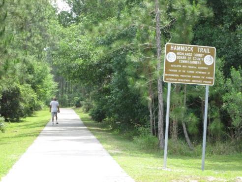
39 Section IV. Trails Network Assessment and Plan Update Blueways, Greenways, Trails and Bikeways Master Plan Highlands County adopted the Blueways, Greenways, Trails and Bikeways Master Plan (Plan) on July 5, The Plan was prepared by The National Park Service: Rivers, Trails and Conservation Assistance Program with assistance from: Archbold Biological Station Fred Lohrer; Audubon Society of Highlands County; Florida Department of Transportation; Highlands County Parks and Recreation Department; Ridge Trails Association; Sebring Historical Society, Inc.; and Trails Initiative Committee (T.I.C.). As part of the Plan, a Blueways, Trails and Bikeways Map was adopted. The Map was updated in September 2005 and is provided below. The Plan was developed with significant consideration to designing future trails to establish interconnections between neighborhoods, business districts, schools, cultural centers, and places of historical significance. The Plan promoted linkages to each of the three municipalities in the County as well as to four middle schools, two elementary schools, and South Florida State College. The existing and proposed trail system passes within 300 yards of four other schools. Many city, county and state parks are located adjacent to planned trails. An update to the Blueways, Greenways, Trails, and Bikeways Master Plan is included as part of Highlands County Parks and Recreation Master Plan (Master Plan). As part of this Master Plan, trail data was updated to reflect trails that have been constructed as well as potential new trails. Updated trail information also includes the proposed trail system identified through the Lake Placid Regional Plan visioning process that occurred between 2005 and Community input received through a recreation survey and at public workshops guided the update to the Plan and Map. Adopted: July 21, 2015 IV-1
40 Definitions The definitions below are referenced throughout this section of the Master Plan. Greenways: Trails: A linear open space established along either a natural corridor, such as a riverfront, stream, or ridge-line, or over land along a railroad right-of-way converted to recreational use, a canal, a scenic road, or other route; any natural or landscaped course for pedestrian or bicycle passage; an open space connector linking parks, natural reserves, cultural features, or historic sites with each other and populated areas; or a local strip or linear park designated as a parkway or greenbelt. Linear corridors and any adjacent support parcels on land or water providing public access for recreation or authorized alternative modes of transportation. Trails are a common recreational component of greenways. Bicycle Trail (Bikeways): Designated trail or system of trails used primarily for bicycling. Canoe and Kayak Trails (Blueways): Distance along most commonly used route on a designated or undesignated waterway used for canoeing and/or kayaking. Equestrian Trail: Improved or unimproved trail designated and used primarily for horseback riding. Fitness Trail (Exercise Par Course): An outdoor exercise track or course especially for joggers equipped with a series of stations along the way where one is to stop and perform a specific exercise. Hiking Trail: Path used solely for backpacking or long distance hiking. Interpretative/Nature Trail: Short to moderate length trail with concentrated informational stops explaining associated views, natural flora and fauna, and/or other features. Multipurpose, Multi-Use, or Shared Trail: Trail used for more than one of activity (walking/hiking/bicycle/nature/equestrian/ canoe & kayak). Such trails are located on exclusive right-of-way and with minimal cross flow by motor vehicles. Adopted: July 21, 2015 IV-2
41 Trailhead: The point at which a trail begins, where the trail is often intended for hiking, biking, horseback riding, or off-road vehicles. Trailheads may contain restrooms, maps, sign posts and distribution centers for informational brochures about the trail and its features, and parking areas for vehicles and/or trailers. Benefits of Greenways and Trails According to the Office of Greenways and Trails (OGT) within the Florida Division of Recreation and Parks, Florida is a leader in greenways and trails. The state was recognized in 2008 as the first-ever Best Trails State in America for its work in facilitating an outstanding statewide system of trails. The system includes thousands of miles of paved, unpaved, and water trails to accommodate hikers, bicyclists, equestrians and paddlers. Greenways and trails provide a multitude of benefits including but not limited to: Making communities better places to live by preserving and creating open spaces; Encouraging healthy lifestyles; Creating opportunities for outdoor recreation and non-motorized transportation; Strengthening local economies; Protecting the environment; and Preserving historical and cultural areas. These benefits have been noted by the National Association of Home Builders in 2008 as trails are the number one community amenity sought by prospective homeowners. In 2011, the University of Massachusetts cited that every $1 million spent on construction of multi-use trails yields 9.6 jobs. In 2012, VISIT FLORIDA documented that 75 percent of all Florida visitors participate in nature-based activities when visiting the state. Community Input Two public workshops were held as part of the development of the Master Plan. At the first workshop, held in July 2014, attendees were asked about the importance of trail connections and community linkages. There were breakout groups in which attendees provided input. In November 2014, a public workshop was held and attendees expressed their priorities for goals regarding trail development which included linkages from neighborhoods to parks and to schools as well as connections to the three municipalities in the County and to the State trails system. (See Section V.) During the November 6, 2014, Public Workshop, the following questions were asked and meeting attendees voted on their priorities. The questions asked and the percentages for each response are provided below. Adopted: July 21, 2015 IV-3
 Improve existing parks and facilities to meet growth in County residents. (64.29 %) (Majority) Maintain existing parks and facilities. (14.29 %) None of the above. (0.")
42 Question 1: Goals: County Parks and Facilities (Please vote for the item below which expresses your highest priority.) New and expanded parks and facilities to attract state or regional events. (21.43 %) Improve existing parks and facilities to meet growth in County residents. (64.29 %) (Majority) Maintain existing parks and facilities. (14.29 %) None of the above. (0.00 %) Question 2: County Connections (Please vote for the item below which expresses your highest priority.) Connect trails to parks and facilities and to regional & statewide system. (50.00%)(Majority) Link existing trails, closing gaps. (28.57 %) Maintain existing trails without further extensions & develop volunteer maintenance efforts. (14.29 %) None of the above. (7.14 %) Question 3: County Connections (Please vote for the item below which expresses your highest priority.) Connect neighborhoods to trails and parks. (35.71 %) (Majority) Connect Avon Park, Sebring and Lake Placid through a unified trails system. (28.57 %) Connect trails to statewide trail system. (21.43 %) None of the above. (14.29 %) Workshop attendees were also asked to vote on the logo that they liked best to identify the County s trails system. The three logos options that were displayed for voting are provided below. Logo % Logo % Logo % Adopted: July 21, 2015 IV-4
43 Logo 2 was included in the County s Blueways, Greenways, Trails and Bikeways Master Plan adopted in July The majority of workshop attendees voted for Logo 2 above. The logo may be used throughout the county to identify the trail system. Trails Assessment Highlands County has many recreation opportunities through greenways and trails. These systems are provided not only by the County but also by others including the Southwest Florida Water Management District, the South Florida Water Management District, the State of Florida, and Florida Fish and Wildlife. Existing and Planned Trails Several organizations and local governments have been involved in developing trails in Highlands County. Many trail projects are administered by various agencies. For County trails, planning and construction is coordinated by the County Engineering Department and the maintenance and operation of trails is addressed by County Leisure Services Department. Table 4-1 includes a list of trails maintained by Highlands County. Table 4-1: Highlands County Maintained Trails System Trail Miles Surface Hammock Multi-Use Trail (US 27 to Highlands Hammock State Park) 3.50 Paved Trails at Sun N Lake Preserve (Balboa Avenue and Sun N Lakes Boulevard) 6.39 Cardiac Loop 0.62 Curvy Run 0.67 Hammock Loop 0.47 Intense 0.14 Unpaved Lots O Logs 0.24 North Trail 1.77 Picnic Loop 1.26 Sum N Else 1.22 South Florida State College Multi-Use Trail 1.39 Paved Memorial Avenue Multi-Use Trail 3.83 Paved Total Adopted: July 21, 2015 IV-5

 Archbold Biological Research Station Highlands Hammock State Park Lake June Scrub State Park Jacks Creek Lake Placid Scrub Preserve Holmes Avenue Scrub Preserve")
44 As indicated on the Trails Map provided in Appendix A, several trails are planned throughout the county. The proposed trails provide connections to existing trails and linkages to the three municipalities as well as to many of the schools in the County and state parks. The proposed trail system runs in proximity to or adjacent to the following areas: Lake Tulane (estimated to be 50,000 years old, considered one of the oldest lakes in Western Hemisphere) Lake Annie (estimated to be 44,000 years old) Archbold Biological Research Station Highlands Hammock State Park Lake June Scrub State Park Jacks Creek Lake Placid Scrub Preserve Holmes Avenue Scrub Preserve Hickory Hammock Venus Flatwoods Preserve Avon Park Air Force Range Lake Wales Ridge Wildlife and Environmental Area Royce Unit Carter Creek National Refuge Adopted: July 21, 2015 IV-6
45 Planning Efforts Highlands County The Highlands County 2030 Comprehensive Plan adopted by the Highlands County Board of County Commissioners has several greenways and trails policies in the Goals, Objectives and Policies throughout the Recreation and Open Space Element and the Transportation Element. The County has developed the trails listed in Table 4-1. Water Management Districts To meet water management needs, both the Southwest Florida Water Management District (SWFWMD) and the South Florida Water Management District (SFWMD) own lands within Highlands County. Water supply, flood protection, protection of natural systems, and water quality are benefits of these lands. In addition, a portion of these lands are available for outdoor recreation including hiking and fishing. Southwest Florida Water Management District (SWFWMD) Jack Creek is a 1,286-acre recreation area owned by the SWFWMD and located on the west side of US 27, south of Sebring on the south side of Josephine Creek. The recreation area is recognized as a Great Florida Birding Trail and includes opportunities for hiking, bicycling, horseback riding, and fishing as well as camping. South Florida Water Management District (SFWMD) The SFWMD owns the Hickory Hammock Wildlife Management Area and the Boney Marsh and Bluff Hammock Management Units in eastern Highlands County. These areas are located north of US 98 and contain portions of the Florida National Scenic Trail. Hiking and equestrian trails and off-road biking are common activities at this facility. Office of Greenways and Trails within the Florida Division of Recreation and Parks The OGT is a clearinghouse for Florida s greenways and trails system and: Plays a leading role in establishing the statewide system of greenways and trails; Provides assistance to communities, developers, and landowners to develop greenways and trails; Provides funding through the Greenways and Trails Land Acquisition Program under Florida Forever and the federally funded Recreation Trails Program; Provides information regarding recreational opportunities and trails in Florida; and Develops information and publications to educate the public about the benefits of greenways and trails. Adopted: July 21, 2015 IV-7


46 Through the OGT s Florida Greenways and Trails System Plan, the State s Greenways and Trails Map is provided as shown below. The Florida Scenic Trail is identified as a state Priority Trail Connection as it parallels the Kissimmee River. Adopted: July 21, 2015 IV-8
47 Florida Cracker Trail Association The Florida Cracker Trail Association s mission is to promote, maintain and enhance the natural beauty of the Florida Cracker Trail while providing a trail for horseback riding, and another trail for bicyclists. The Association s goal is to provide a trail connecting the east coast of Florida to the west coast of Florida. The Florida Cracker Trail is proposed to run along the SR 66 and US 98 corridors in Highlands County. Trail Design Trail design guidelines vary based on the type of trail proposed (shared or separate bikeway, nature trail, equestrian trail, multi-use trail). In order to provide opportunities to the greatest number of people, trails should provide a variety of distances, loops, ecosystems, scenery, and linkages. Construction should cause minimal impact to the area. Trails with a high volume of use should accommodate all users where appropriate and conform to the intent and spirit of ADA guidelines and the Florida Americans with Disabilities Accessibility Implementation Action (Florida Statutes). Efforts should be made to consider linkages to historical and archeological sites as part of the trail system. Construction Guidelines The purpose of this section is to outline general construction standards for recreational trail building. Standards are basic guidelines that illustrate typical trail dimensions and construction practices. They are intended to be used as suggested practices for constructing a trail system and may not apply to every situation. The site conditions for a proposed trail route will be variable along every segment of the Highlands County Trail System so these standards will provide ideas on how best to proceed with planning and construction. Typical sections for the common existing and planned trails in the County are provided below. Adopted: July 21, 2015 IV-9
48 Bike Lane Sharing Roadway Bicycle lanes serve the needs of all types of cyclists in urban and suburban areas, providing them with their own travel lane on the street surface. The minimum width of a bike lane should be 5 feet against a curb or adjacent to a parking lane. On streets where the bike lane is adjacent to the curb and the curb includes a 1-foot to 2-foot gutter pan, bike lanes should be a minimum of 4 feet wide (width does not include the gutter pan, since bicyclists are typically unable to use this space). Since bicyclists usually tend to ride a distance of 2.5 feet to 3.5 feet from the curb face, it is very important that the pavement surface in this zone be smooth and free of structures. Drain inlets and manholes that extend into this area cause bicyclists to swerve, having the effect of reducing the usable width of the lane. Where these structures exist and the surface cannot be made smooth, bike lane width should be adjusted accordingly. Regular maintenance is critical for bike lanes. Bike lanes should be constructed to normal full-depth pavement standards since motor vehicles will occasionally cross them, or may use them as a breakdown area. Where the minimum widths listed above cannot be met, it may be possible to provide an unmarked lane. Studies have shown that the bicyclist s perceived level of comfort is higher when a striped area is provided; therefore, this method can raise the bicycle level of service for the street. An unmarked lane is a striped area of 2 feet wide or more that contains no markings or signing that would denote it as a bike lane. Share the Road signs may be used to caution motorists to be alert for bicyclists (Figure 4.1). Figure 4.1: Typical Section for a Bike Lane Sharing Roadway Adopted: July 21, 2015 IV-10
49 Multi-Use Trail As illustrated in Figure 4.2, a 5-foot buffer is recommended between an off-road multi-use trail and the existing roadway. The multi-use trail should be paved and a minimum of 8 to 10 feet in width, which allows for two-way traffic to safely pass along the trail. Improved Surface Trail - consists of high-use trails located mainly within urban and suburban areas. A typical tread width ranges from 10 to 16, depending on anticipated user volume. Tread surface would be granite gravel, concrete, asphalt (discouraged for trails near waterways due to negative water quality impacts), or other added material including porous pavement systems. These trails could have bridges, and typically have amenities such as information kiosks, benches, drinking fountains, rest rooms, exercise facilities, etc at trail heads. Improved surface trails where possible will be built to conform to AASHTO and/or ADA standards. Natural Surface Trail - are located mainly in greenways or natural resource areas. A typical trail width ranges from 2 to 10 depending on specific uses. Trail tread would be existing natural soil that has been cleared, grubbed of rocks and roots, leveled and compacted. These trails would have limited amenities such as way finding. Figure 4.2: Multi-Use Trail Typical Section Adopted: July 21, 2015 IV-11

50 Equestrian Trail Dual tread trails are suggested on multi-use trail systems where different users travel at different speeds, such as equestrians and walkers. If hard surfacing is being used on the multi-use trail, a softer, 5-foot wide tread for horses should be considered. Mulch, dirt, stabilized dirt or limestone dust can be used. Hard surfaces, such as concrete and asphalt are undesirable for equestrians because they can injure horses hooves. Granular stone may also present problems because it can get stuck in horse hooves. Vertical clearance for equestrians should be at least 10', with a horizontal clearance of at least 5 feet. Low-hanging tree limbs should be cut flush with the trunk. Leaves, branches, and other protrusions that could injure the horse, rider, or gear should be removed. Within the tread, stumps, large rocks, and other debris should be cleared. Sight distances for equestrians, who usually travel between 4 and 6 miles per hour, should be at least 100 feet. Horses can be easily scared by sudden movements therefore it is recommended that a separate trail be used solely for equestrian use. A 4-foot mulch surface (or limestone dust surface) may be used in order to reduce erosion from heavy use. Trees and other landscape materials should be well maintained and kept clear to avoid collisions of riders with low overhangs from trees (Figure 4.3). Figure 4.3: Equestrian Trail Typical Section Adopted: July 21, 2015 IV-12

51 Canoe and Kayak trail (Blueway) Blueways offer opportunities for canoeing and kayaking on some of central Florida s most scenic waterways. Unlike bikeways, water trails already exist. What is needed is help for trail users to get to the water and to find their way around. Signs, route markers, maps, and promotion of water routes are essentials. Trail supporters can create more opportunities by providing facilities like parking, boat ramps or docks, and places to camp and picnic. It is important to provide safe access points to the blueways (Figure 4.4). Figure 4.4: Blueways Typical Section Trail Markings Trail markings should be standardized, easy to understand, identifiable, weather resistant and durable. Such markers should be placed strategically along trails to indicate hazardous points and directional changes. Signs, maps, and brochures should be provided at trailheads, and information should be appropriately placed along the trail to indicate permitted type of trail use, trail difficulty rating, information for trail users on how far they have traveled, and their approximate location on the trail. Figure 4.5: Examples of Trail Markings Adopted: July 21, 2015 IV-13

52 Trailheads There are 18 trailheads in Highlands County. The majority of the trailheads do not have public restrooms. There are three types of trailheads including: Primary Trailhead: Consists of designated parking and staging area, public restrooms, trash receptacles, informational and interpretive signs, maps or brochures, potable water, picnic facilities, covered shelters, and other appropriate amenities. Secondary Trailhead: Consists of designated parking and staging area, possible restrooms, trash receptacles, information signs, maps or brochures, potable water, and covered shelter. Remote/Primitive Trailhead: Includes a parking and staging area, information signs, maps or brochures. Sun N Lake Preserve Remote/Primitive Trailhead Trail Priorities, Goals, and Recommendations Trail Priorities Trail priorities are based on factors including: Trail system connectivity; Transportation connectivity; Recreational connectivity; Scenic/Experience value; Environmental impacts; Stakeholder input; and Availability of right-of-way. Adopted: July 21, 2015 IV-14
53 A trail s value is directly linked to its location in providing connectivity to other recreation opportunities as well as destinations. The trail s scenic value is also important. Key priorities identified through public involvement included linking trails from neighborhoods to parks to schools. Right-of-way availability is also an important factor and maybe the most challenging aspect providing continuous trails. Opportunities may be available through easements, dedications, public or private right-of-way reservation, and joint use agreements. Strategies to obtaining right-of-way include: Abandoned Railroad (Rails-to-Trails) Active Railroad (Rails-with-Trails) Rail Banking Roadway Co-location Inclusion in New Development Public Land Private Property (Easements). Trails Goals and Objectives, Recommendations The Highlands County 2030 Comprehensive Plan has several Goals, Objectives, and Policies throughout the Recreation and Open Space Element and the Transportation Element that relate to trails. The recommendations below capture those as well as new priority goals which were outcomes from the Community Workshops held to develop the Parks and Recreation Master Plan and to Update the Blueways, Greenways, Trails and Bikeways Master Plan. Recommendations 1. The Trails Map and Plan should be adopted by the Heartland Regional Transportation Planning Organization and the Highlands County Board of County Commissioners as the basis for the systematic implementation of an integrated regional trail network. 2. The Trails Map should be distributed to all municipalities, the County, state including the Florida Department of Transportation and federal agencies with jurisdiction over the property along a proposed trail alignment. 3. The Trails Map and Plan should be reviewed, evaluated, and updated as needed in conjunction with the Office of Greenways and Trails within the Florida Division of Recreation and Parks, but at least every five years. The purpose of the review is to take advantage of opportunities that may arise, to re-establish or re-allocate priorities, and to update the status of current projects. Adopted: July 21, 2015 IV-15
54 4. All new development/redevelopment and road construction projects should implement those trails from the Highlands County Trails Network that are within the vicinity of the project where feasible. 5. As part of assessing and developing new trail routes and making modifications to existing trail routes, follow the prioritization guidelines. 6. Prior to sale of any County property, the property should be evaluated to determine potential use for a trail link or facility. 7. The interdepartmental review of developments and other infrastructure projects should be strengthened to specifically require a review of the project for provision of a linkage to the trails system. 8. The trail network will be phased over time in association with new development and county and municipal infrastructure improvement projects. Projects may also be implemented based on changing construction opportunities or specific trail related demand. 9. Evaluate and determine gaps within the Trails Network Map to identify the best target resources and funding. 10. Detailed route design for stand-alone trails will utilize public involvement with local neighborhoods and agencies where public involvement is deemed necessary by County staff. 11. Annual capital budgets should include opportunities for the implementation of the trails network. 12. The County should coordinate with municipalities and state providers to connect trails to parks and facilities and to regional and statewide system. 13. The County should work to link existing trails and reduce trail gaps. 14. The County should work to connect neighborhoods to trails and parks. 15. The County should work to connect Avon Park, Sebring and Lake Placid through a unified trails system. 16. The Highlands County Board of County Commissioners should specifically charge the Engineering Department with implementation of the Blueways, Greenways, Trails and Bikeways Master Plan. The Highlands County Board of County Commissioners should provide the resources to implement the Trails Plan as feasible. Adopted: July 21, 2015 IV-16

55 Section V: Community Input An important component to the drafting of the Parks and Recreation Master Plan and Trails Master Plan Update is the input and comments received from the public. Public involvement was achieved through workshops and meetings, a dedicated project website, and a recreation survey. Information about the project was disseminated through public notices in the newspaper, the distribution of flyers and post cards, notices on websites, and word of mouth including social media such as Facebook. Workshops and Meetings The creation of the Parks and Recreation Master Plan required input from county and city staff, the Highlands County Recreation and Parks Advisory Committee (RPAC), elected officials, stakeholders, and the public. Several meetings were held throughout the process, including: Community Workshops To engage the public in the process and to receive input and comments, two public Community Workshops occurred. Both Community Workshops were advertised in the newspaper, on the project website and the County s website. Postcards and flyers were distributed to residents at parks and recreation locations and through the local governments. July 31, 2014 The Community workshop held on July 31, 2014, introduced the participants to the Parks and Recreation Master Plan. After a presentation outlining the components of a parks and recreation plan, the attendees were asked to separate into breakout groups. The facilitators rotated to each group to discuss and receive input on the following topics: Active and Passive Recreation Programs Types and Need Facilities Current and Future Connections Links between neighborhoods and facilities and trails. Adopted: July 21, 2015 V-1

 followed by connections (29 percent of the vote) and active and passive recreation (25 percent of the vote).")
56 After reporting the results of the breakout groups to the overall groups, the participants were given $100 of play money (five $20 dollar bills). They were asked to show how they would spend the money between the four categories discussed in the breakout groups. An option for not spending the money was also provided. Approximately 72 percent of the votes received were for spending money on one of the four categories (Figure 5.1). The participants spent the most dollars on facilities (41 percent of the vote) followed by connections (29 percent of the vote) and active and passive recreation (25 percent of the vote). Programs received very few of the participants dollars (5 percent of the vote) (Figure 5.2). Figure 5.1: Parks & Recreation Dollar Voting Results 28% Spend Money Spend No Money 72% Figure 5.2: Parks & Recreation Dollar Voting Results 45% 40% 35% 30% 25% 20% 15% 10% 5% 0% Active and Passive Recreation Facilities Programs Connections Adopted: July 21, 2015 V-2

57 November 6, 2014 The Community Workshop on November 6, 2014, began with attendees viewing display boards at the entrance to the facility which provided information on the survey results received to date, county demographics through 2030, a map of county parks, and a map of county trails. Staff members were available to discuss the display boards with the attendees and to record any comments. The Community Workshop included a presentation outlining the Parks and Recreation Master Plan, summarizing the input received at the July 31 st Community Workshop, summarizing the survey results, and discussing connections and linkages. The attendees were asked to separate into breakout groups where they discussed existing trail connections and opportunities for trail connections. The discussions focused on the communities of Avon Park, Sebring, and Lake Placid. After reporting the results of the breakout groups to the overall groups, the participants were given handheld instant voting devices to vote on different statements relating to the goals to be formed for the Parks and Recreation Master Plan. The handheld instant voting devices allow the participants to express their preference anonymously and instantaneously. The software records the results for staff s use. Highlands County Recreation and Parks Advisory Committee (RPAC) The Highlands County Recreation and Parks Advisory Committee (RPAC) advises the Board of County Commissioners and its staff on issues pertaining to the creation of a balanced county-wide recreation program and integrated recreation facilities inventory, guided by the respective Recreation and Open Space Elements of the Avon Park, Sebring, Lake Placid and Highlands County Comprehensive Plans. The RPAC was involved in the update of the Parks and Recreation Master Plan. Staff presented updates to RPAC at their meetings throughout the process. County Commission and Planning and Zoning Commission On December 9, 2014, staff provided a briefing on the project to the Planning and Zoning Commission. The briefing included an explanation of the project and information on the update process. A summary of the input received at the two Community Workshops was outlined. On January 20, 2015, staff provided a summary of the project and the public information received to the Highlands County Board of County Commissioners. Adopted: July 21, 2015 V-3


58 Project Website A project specific website was established to provide information regarding the Parks and Recreation Master Plan process. The website also hosted the survey and served as a vehicle for the public and interested stakeholders to provide comments and input. The website is located at: Parks and Recreation Survey During the summer of 2014, the public was asked to complete a Parks and Recreation Survey to provide information on their demographics, the parks and recreation facilities they use, and their thoughts on the needs for additional parks and recreation facilities. The public submitted 243 surveys. While 243 surveys were submitted, not all survey respondents answered each question. The following information is a summary of the information obtained from the received surveys. Demographic Information The majority of the respondents are from the Lake Placid or Sebring Area. Approximately 5 percent of the survey respondents did not provide any information as to what area of the county in which they reside (Figure 5.3). While the majority of the respondents range in age from 35 years old to 64 years old, there were participants that declared themselves to be between 18 and 24 years old or under 17 years old (Figure 5.4). Almost half the respondents (47 Adopted: July 21, 2015 V-4
. Figure 5.")
59 percent) have no children under the age of 18 living in the household. Approximately 17 percent of the respondents have one child under 18 and 13 percent of the respondents have two children under the age of 18 in the household (Figure 5.5). Figure 5.3: Survey Response by Area 0.8% 0.4% 4.5% 11.9% Avon Park Lake Placid 39.9% Lorida Sebring 40.7% Venus Jacksonville 1.6% Not provided Figure 5.4: Age Range of Survey Respondents 25% 20% 15% 10% 5% 0% 17 years or younger years or older not provided Adopted: July 21, 2015 V-5


60 Figure 5.5: Number of Children Under 18 in Household 50% 40% 30% 20% 10% 0% or more not provided Parks and Recreation Information Survey respondents did not respond to every question in the survey. The information and graphs that follow are based on those surveys that answered each specific question. Participation Slightly more than half of the respondents (54.7 percent) said they or members of their household participated in recreation or sports activities or programs offered at Highlands County facilities in the past 12 months (Figure 5.6). Figure 5.6: Participation in Highlands County Parks & Recreation Yes 45.3% No 54.7% Adopted: July 21, 2015 V-6

61 Of the responses received, 48 percent of the respondents said they participated in 2 to 3 sports or activities in the last 12 months, 25 percent participated in 1 activity, and 19 percent participated in 4 to 6 activities. Three percent of the respondents said they participated in 7 to 10 activities and 5 percent said they participated in 11 or more activities or sports in the last 12 months (Figure 5.7). Figure 5.7: Number of Activities or Sports in Last 12 Months 50% 40% 30% 20% 10% 0% or more The respondents were asked to list all the sports/activities they participated in over the last 12 months. Water related sports such as boating, fishing, and swimming made up approximately 40 percent of the responses. Team sports including baseball, soccer, football, and basketball made up approximately 26 percent of the responses. Passive recreation activities such as walking, hiking, biking, and bird watching comprised approximately 24 percent of the responses (Table 5-1). Table 5-1: Sports and Activities Survey Respondents Participated in Over the Last 12 Months Sports/Activities Count Percentage ATV and Four-wheeling % Baseball, Softball, Soccer, Football, Basketball, T-Ball % Boating, Kayaking, Fishing, Swimming % Hiking, Walking, Trails, Biking, Bird Watching, Horseback Riding, Nature Photography, Fireflies, Camping % Playground, Picnic, Concerts, Parties % Tennis, Golf, Archery, Pickle ball % Adopted: July 21, 2015 V-7
62 Quality and Condition When asked to rate the quality of the activities or sports based on participation in them over the last 12 months, 49 percent of the responses received provided a rating of good, 22 percent provided a rating of fair, and 19 percent provided a rating of excellent. A rating of poor was provided by 4 percent of the respondents and 6 percent had no opinion (Figure 5.8). Figure 5.8: Rate Quality of Activities or Sports Based on Participation 50% 40% 30% 20% 10% 0% Excellent Good Fair Poor No Opinion In response to the question of rating the overall condition of parks and recreation facilities visited in the last 12 months, 46 percent of the respondents rated them good, 29 percent rated them fair, and 16 percent rated them excellent. A rating of poor was provided by 6 percent of the respondents and 4 percent had no opinion (Figure 5.9). Figure 5.9: Overall Condition of Parks & Recreation Facilities 50% 40% 30% 20% 10% 0% Excellent Good Fair Poor No Opinion Adopted: July 21, 2015 V-8
63 Facilities Survey respondents were asked to select all facilities they or members of their households had used during the past 12 months. Some of the survey respondents chose to skip over these questions. General Facilities The survey separated General Facilities out by location and included Highlands County, Avon Park, Sebring, and Lake Placid. Figure 5.10 illustrates the facility usage by age group. According to survey respondents, Highlands County facilities receive the most use by the year old age group while Lake Placid facilities receive the most use by the year old age group. Both Avon Park and Sebring facilities receive the most use by the year old age group. Figure 5.10: Facility Use by Age Group 40% 30% 20% 10% 0% 17 years or younger years or older Avon Park Sebring Lake Placid Highlands County Adopted: July 21, 2015 V-9
 and Multi Sports Complex (31 percent). Figure 5.")

64 Highlands County There are six general facilities located in Highlands County. Figure 5.11 illustrates the six facilities and the percentage of use over the past 12 months by survey respondents. Of the six facilities, the facilities identified as having the highest use include HL Bishop Park (51 percent) and Multi Sports Complex (31 percent). Figure 5.11: Highlands County Facilities Visited in Last 12 Months DeSoto Ball Field 60% 50% 40% 30% 20% 10% HL Bishop Park Lincoln Heights Lorida Ball Field Martin Luther King Park Multi Sports Complex 0% Avon Park There are nine general facilities located in Avon Park. Figure 5.12 illustrates the nine facilities and the percentage of use over the past 12 months by survey respondents. Of the nine facilities, the facilities identified as having the highest use include Donaldson Park Tennis Courts (35 percent) and Martin Luther King, Jr. Field (Memorial Field) (21 percent). Figure 5.12: Avon Park Facilities Visited in Last 12 Months 40% 30% 20% 10% 0% Activities Club Aline McWhite Basketball Courts Avon Park Recreation Center Donaldson Park tennis Courts Durrah Martin Complex Head Field Complex Lucy Derkman Softball Complex Martin Luther King, Jr. Field (Memorial Field) Walnut Street Park Adopted: July 21, 2015 V-10
 and Devane Park (26 percent). Figure 5.")

65 Lake Placid There are four general facilities located in Lake Placid. Figure 5.13 illustrates the four facilities and the percentage of use over the past 12 months by survey respondents. Of the four facilities, the facilities identified as having the highest use include Lake June Park/Sports Complex (44 percent) and Devane Park (26 percent). Figure 5.13: Lake Placid Facilities Visited in Last 12 Months Devane Park 50% 40% 30% 20% 10% John's Park Lake June Park/Sports Complex Stuart Park 0% Sebring There are seven general facilities located in Sebring. Figure 5.14 illustrates the seven facilities and the percentage of use over the past 12 months by survey respondents. Of the seven facilities, the facilities identified as having the highest use include Veterans Beach Park (37 percent) and City Pier (35 percent). Figure 5.14: Sebring Facilities Visited in Last 12 Months 40% 30% 20% 10% Charlie Brown Park City Hall Tennis Court City Pier Gabe White Park Sebring Golf Course Skate Park Veterans Beach Park 0% Adopted: July 21, 2015 V-11
.")

66 Nature Trails The survey identified three Nature Trails (Figure 5.15). Survey respondents were asked to identify all of the nature trails they visited in the last 12 months (multiple nature trails could be selected). Their use patterns are as follows: Hammock Trail 57 percent; Lake Istokpoga Park 28 percent; The Preserve of Sun N Lake 16 percent. Figure 5.16 illustrates the use of nature trails by age group. Figure 5.15: Nature Trails Visted in Last 12 Months 15.7% 56.7% Hammock Trail Lake Istokpoga Park The Preserve of Sun 'N Lake 27.5% Figure 5.16: Nature Trail Use by Age Group 25% 20% 15% 10% 5% 0% 17 years or younger years or older Adopted: July 21, 2015 V-12
.")
67 Boat Ramps There are a variety of boat ramps available for use throughout Highlands County. Survey respondents were asked to identify all of the boat ramps they visited in the last 12 months (multiple boat ramps could be selected). The boat ramps were divided by location: Avon Park, Lake Placid, Lorida, and Sebring. On a countywide basis, the boat ramps with the highest use are Lake June - H.L. Bishop Park, Istokpoga Park, Lake Placid (3349 Placid View Dr.), and Lake Istokpoga Windy Point. Figure 5.17 illustrates the boat ramp use by age group in the different areas. Table 5-2 includes the boat ramps with the highest use by area and the Figures 5.18 through 5.21 illustrate usage for each boat ramp by area according to the survey respondents. Figure 5.17: Boat Ramp Use by Age Group 50% 40% 30% 20% 10% 0% Avon Park Lake Placid Lorida Sebring 17 years or younger years or older Table 5-2: Boat Ramp Facilities with Highest Use by Area in the Last 12 Months Facilities Percentage Avon Park Lake Lotela 15.29% Arbuckle Creek (Burnt Out Bridge) 12.94% Lake Denton 11.76% Lake Placid Lake June - H.L. Bishop Park 26.44% Lake Placid (3349 Placid View Dr) 15.38% Lake Istokpoga Windy Point 13.94% Lorida Istokpoga Park 46.05% Lake Istokpoga (off Cow House Rd) 30.26% Arbuckle Creek (6401 E. Arbuckle Creek Rd.) 23.68% Sebring Lake Josephine (Sentinal Point) 21.57% Lake Sebring 19.61% Red Beach Lake 19.61% Adopted: July 21, 2015 V-13
 Lake Adelaide Lake Damon Lake Denton Lake Glenda Lake Lelia Lake Letta Lake Lotela Lake")
 Lake Clay (west side) Lake Francis Lake Huntley (123 Lake Huntley Dr) Lake Huntley (end of Anderson St) Lake Istokpoga Boggy Branch Lake Istokpoga")
68 Figure 5.18: Avon Park Boat Ramps Visited in Last 12 Months Arbuckle Creek (Burnt Out Bridge) Lake Adelaide Lake Damon Lake Denton Lake Glenda Lake Lelia Lake Letta Lake Lotela Lake Olivia Lake Pioneer Lake Viola 0% 2% 4% 6% 8% 10% 12% 14% 16% Little Lake Bonnet Little Lake Redwater Figure 5.19: Lake Placid Boat Ramps Visited in Last 12 Months Lake Apthorpe Lake Carrie Lake Clay (East side) Lake Clay (west side) Lake Francis Lake Huntley (123 Lake Huntley Dr) Lake Huntley (end of Anderson St) Lake Istokpoga Boggy Branch Lake Istokpoga Windy Point Lake June - H.L. Bishop Park Lake Persimmon Lake Placid (150 Harris Dr) 0% 5% 10% 15% 20% 25% 30% Lake Placid (3349 Placid View Dr) Adopted: July 21, 2015 V-14

 Istokpoga Park Lake Istokpoga (off Cow House Rd) 0% 10% 20% 30% 40% 50%")
 Lake Josephine (425 Lake Josephine Shore")
69 Figure 5.20: Lorida Boat Ramps Visited in Last 12 Months Arbuckle Creek (6401 E. Arbuckle Creek Rd.) Istokpoga Park Lake Istokpoga (off Cow House Rd) 0% 10% 20% 30% 40% 50% Figure 5.21: Sebring Boat Ramps Visited in Last 12 Months Dinner Lake Lake Josephine (2430 Oak Beach Blvd) Lake Josephine (425 Lake Josephine Shore Rd) Lake Josephine (Sentinal Point) Lake Sebring Red Beach Lake 0% 5% 10% 15% 20% 25% Wolf Lake Adopted: July 21, 2015 V-15
70 Recreation Needs The survey asked respondents to identify if any member of the household has a need for specific recreation and sports programs. For programs identified as needed, the respondents were asked to rate how well their needs are met for that program. Table 5-3 on the following page includes the listed programs and the results of those surveys that responded to the question. For youth programs, the highest needs were for sports (45 percent), fitness and wellness (35 percent), and swim lessons (31 percent). For adults, the highest need was for fitness and wellness (67 percent). The survey respondents did not identify a high need for either programs for persons 55 years and older (27 percent) or for programs for disabled persons (17 percent). Table 5-3: Need for Recreation and Sports Programs Program Need for the Program If Yes, How Well is Need Being Met Yes No 0% 25% 50% 75% 100% Youth Swim Lessons 31% 69% 15% 25% 25% 15% 21% Summer Camp 25% 75% 34% 19% 17% 19% 11% Sports 45% 55% 8% 15% 25% 32% 21% Fitness and Wellness 35% 65% 16% 21% 30% 23% 10% Tennis Lessons & Leagues 18% 82% 55% 15% 23% 3% 5% Golf Lessons and Leagues 16% 84% 45% 16% 26% 6% 6% Adult Fitness & Wellness 67% 33% 13% 20% 30% 20% 17% Sports Lessons & Leagues 32% 68% 20% 34% 26% 11% 9% Tennis Lessons & Leagues 14% 86% 46% 35% 12% 0% 8% Golf Lessons & Leagues 17% 83% 26% 16% 26% 13% 19% Special Areas Programs for Persons 55 Years or Older 27% 73% 24% 31% 18% 18% 10% Programs for People with Disabilities 17% 83% 37% 37% 10% 10% 7% Adopted: July 21, 2015 V-16


71 Recreation Sources According to Survey respondents, the availability of information related to parks and recreation facilities and activities is fair. Approximately 42 percent of the respondents who answered this question said information availability is fair while 26 percent said it is good and 22 percent said it is poor. Six percent of the respondents who answered the question said they had no opinion and 4 percent said information availability is excellent (Figure 5.22). Figure 5.22: Availability of Information to Community 45% 40% 35% 30% 25% 20% 15% 10% 5% 0% Excellent Good Fair Poor No Opinion As illustrated in Figure 5.23, the majority of the respondents receive their information from friends and neighbors (37.5 percent) or through newspaper articles (25 percent). The Highlands County Website serves as a source of information for 14 percent of the respondents. Some of the sources identified under Other in Figure 5.23 include: Street signs Library Social media and websites Radio Club organizations School announcements and flyers Chamber of Commerce Adopted: July 21, 2015 V-17

72 Figure 5.23: Sources of Information 4.5% 1.8% 10.0% 37.5% Avon Park Website From Friends and Neighbors Highlands County Website 25.0% Lake Placid Website Newspaper Articles Other 7.3% 14.0% Sebring Website Survey respondents were asked to identify all the organizations they utilized for their indoor and outdoor recreation and sports activities in the last 12 months. As illustrated in Figure 5.24 on the following page, the top three responses include: Highlands County Facilities (14.4 percent), School District Facilities (13.7 percent), and a tie for the Town of Lake Placid and Churches (12.7 percent each). Some of the organizations identified as Other by survey respondents in Figure 5.24 include: Highlands Hammock State Park Theater Library Sun n Lake and Englewood pickleball courts Neighborhood sidewalks and streets Golf courses throughout the county Locations outside of the county. Adopted: July 21, 2015 V-18
 Private youth sports leagues")

73 Figure 5.24: Organizations Used For Recreation Churches City of Avon Park City of Sebring Colleges Highlands County Faciilities Other Private clubs (tennis, health, fitness, etc) Private youth sports leagues School District Facilities Town of Lake Placid 0% 2% 4% 6% 8% 10% 12% 14% 16% YMCA Parks and Recreation Improvements The respondents were asked to choose their top two choices for how Highlands County parks and recreation system could be improved. Figure 5.25 below illustrates the results. Figure 5.25: Top Two Choices to Improve Value 8.0% 21.1% 10.1% 12.2% Upgrading existing passive parks Other Providing recreation programs and activities Acquiring land for future parks 20.2% Developing new active parks 13.1% Acquiring natural areas 15.4% Building new major facilities Adopted: July 21, 2015 V-19
74 As illustrated in the Figure 5.25 on the previous page, the top two choices made by the respondents were: Upgrading existing passive parks (21 percent) and Other (20 percent). Some of the ideas listed under Other include: Development of multi-use paths Outdoor fitness areas Funding and maintaining existing facilities Improvements and additions of facilities bleachers, restrooms, etc. Dog park Public swimming pool Water Parks and spray parks Camping areas Walking track or trails, soccer fields, picnic shelters with facilities and grills, etc. Indoor activities Special needs playground Equine Facilities Survey respondents were asked if they felt there was a need to provide a connection between neighborhoods and parks and recreation facilities. Of the respondents that answered the question, the majority (67.8 percent) answered yes. Approximately 19 percent said maybe and 14 percent said no (Figure 5.26). Figure 5.26: Need for Connection 13.6% 18.7% Yes Maybe No 67.8% Survey respondents responded favorably to the questions of if they would you be interested in Highlands County providing additional recreation activities or programs if there was an additional fee. As illustrated in Figure 5.27, approximately 42 percent said yes, 37 percent said maybe, and 20 percent said no. Adopted: July 21, 2015 V-20
75 Figure 5.27: Additional Recreation Programs or Activities with Additional Fees 20.3% 42.3% Yes Maybe No 37.4% The survey asked respondents to state their opinion for the most important addition or improvement to the Highlands County Parks and Recreation activities, programs, or facilities. Some respondents stated that no changes should be made. Of the respondents who identified changes, the following list summarizes the variation of responses: Water park Dog park Passive recreation Active parks frisbee golf, soccer, baseball, batting cages, volleyball Aquatic activities swimming, boating, fishing Off-road facilities Biking, walking, hiking, fitness trails, horsetrails, multi-use trails connections between trails Camping areas Firearms range for pistol, rifle, and bow Family friendly Maintenance of and improvements to existing facilities cleaning, safety, and upgrading More children and teen activities Easy access for everyone disabled and elderly More awareness and advertising More complexes and playgrounds More lake access Community gardening Adopted: July 21, 2015 V-21
76 This page was intentionally left blank. Adopted: July 21, 2015 V-22
77 Section VI: Plan Objectives As part of the development of the Parks and Recreation Master Plan and Trails Master Plan Update, a mission statement and objectives were developed to help guide the development of the County s parks and recreation system. The County may consider the mission statement and objectives before making decisions related to the parks and recreation system. Mission Statement The following mission statement has been drafted through the community input and development of the Parks and Recreation Master Plan and Trails Master Plan Update. Highlands County will facilitate the management of facilities for a recreation system that includes parks, trails and other recreational opportunities that meet the needs of a growing community. The County shall continue to seek opportunities for a connected recreation system linking neighborhoods, trails and parks. Objectives The following are objectives in support of the mission statement. Objective 1: Highlands County will develop, operate, and promote a parks and recreation system that provides all residents with quality recreation opportunities. Objective 2: The Highlands County Leisure Services Department should coordinate with staff of the Highlands County Visitors and Convention Bureau to help promote Highland County s parks, trails, cultural events, natural areas, and special events to visitors. Objective 3: Highlands County should develop and distribute a web-based promotional guide for parks and recreation facilities and trails owned and operated by the County. Objective 4: A logo and signage program should be initiated that becomes an identifier for the Highlands County parks and recreation system, strengthening the image and recognition factor by residents of, and visitors to, Highlands County. Adopted: July 21, 2015 VI-1
78 Objective 5: Highlands County will continue a presence on the County s website specifically for the Leisure Services Department that is updated regularly and contains useful information regarding programs, facilities, an interactive map, other recreation providers, volunteer opportunities, and upcoming events. Objective 6: Highlands County will facilitate the development of a well-balanced system of community and regional facilities that include active and resource based recreational communities to meet a variety of needs for individuals as well as groups. Objective 7: The park classification system in Highlands County will be limited to community parks, district parks, and special facilities. Parks will be further classified as either resourcebased or activity-based. Objective 8: Highlands County Leisure Services Department shall maintain an up-to-date inventory of all Highlands County maintained park facilities. Objective 9: When developing new parks and facilities, Highlands County shall include nearby residents and other interested parties in the planning process. Objective 10: Highlands County will create and approve a phased development and renovation plan for the existing parks in the System to determine appropriate development of new facilities and/or phase out of parkland that does not meet the objectives of the Master Plan. Objective 11: Highlands County shall pursue development of a payment in lieu of parks fee in which developers may contribute money to the government having jurisdiction, equal to the value of the number of developed park acres required; or in the alternative, acquire and convey to the government park acreage (equal in value to the required developed park acreage) in lieu of parks. Adopted: July 21, 2015 VI-2
79 Objective 12: Highlands County will foster the development of a comprehensive trails, blueway and bikeway system that provides scenic, eco-tourism and resource-oriented recreation. Objective 13: Highlands County shall continue working towards implementing its trails program by coordinating with federal, state, regional, and local public agencies and private organizations. Objective 14: Highlands County shall add greenways and blueways to its trails and bikeways program to help connect natural resources and parks to the trail system. Objective 15: Highlands County shall reference as a guideline the Florida Bicycle Facilities Planning and Design Handbook by FDOT and the Florida Office of Greenways and Trails Reference and Resource Guide. These documents shall be used in the planning and development of trails. Objective 16: Highlands County will ensure equal access and maximum availability to all facilities. Objective 17: Highlands County shall design, construct, and manage parks and trails with access ways that are compatible with the natural features and character of the individual park site. Objective 18: Sidewalks, bikeways, and/or trails should be provided to link residential areas, community facilities, schools, and other park sites where feasible. Objective 19: Highlands County will continue to promote access to water bodies and natural resources through the development and maintenance of public access points, swimming areas, boat ramps, and canoe/kayak launches. Objective 20: In order to reduce vandalism and crimes in County parks, Crime Prevention Through Environmental Design (CPTED) methods, programs and techniques may be integrated in Adopted: July 21, 2015 VI-3
80 the design where feasible and appropriate for the operation of County public parks, trails, and environmental lands. Objective 21: Highlands County recognizes that it is imperative to identify and implement methods to finance the on-going operation and management of its facilities. a) Highlands County shall focus on providing larger scale facilities. These facilities will supplement existing city recreation facilities, natural resource based parks, and a trails system linking them all together. b) Design of new facilities should incorporate revenue-generating opportunities that could offset operational costs and/or enhance the recreational experience of participants (i.e. concessions, rentals, etc). c) The County s grant-funded programs should be refined to be consistent with the objectives of the Master Plan. d) A reliable and consistent capital funding source for recreation facilities and operations should be established to help implement the Master Plan. e) The County shall consider adoption of fair and equitable fees and charges, where appropriate, for the Parks and Recreation System for both residents and visitors that use County facilities. f) New park and trail development shall address the cost to maintain each facility prior to construction. Design/maintenance techniques, materials, and procurement methods should be used to provide the most cost effective measures to develop and maintain, the park and trail facilities. Objective 22: Highlands County recognizes that continuation, growth and effectiveness of the County s Parks and Recreation system will depend on the ability to focus on a formalized mission and the ability to develop and maintain partnerships with the municipalities, including Avon Park, Sebring and Lake Placid, the Highlands County School Board and the Water Management Districts. a) Highlands County shall continue to investigate alternative funding sources and relationships to provide for public park facilities, programs, and management. Adopted: July 21, 2015 VI-4
81 b) Highlands County and the School Board should further work to co-locate sites for new and existing schools and parks where feasible. Highlands County should work with the School Board to identify possible joint opportunities to provide athletic and recreation opportunities for students and citizens. A school/park design prototype should be developed to be used for planning such joint facilities. Highlands County and the School Board should also work to identify existing school sites for possible improvements to better accommodate public recreation usage. c) Highlands County should work with the School Board to develop a model Mutual Use Agreement for the public use of joint school and park facilities. d) Highlands County shall continue to coordinate with the County s municipalities and adjacent counties for the provision of public parks and recreational programming through the use of interlocal agreements. e) Highlands County shall develop agreements with non-profit recreation providers such as the YMCA and Boys and Girls club to provide recreational programming and facilities. f) Highlands County shall pursue joint agency funding for the purchase, development, and management of public parks, environmental lands, and trails. Adopted: July 21, 2015 VI-5
82 This page was intentionally left blank. Adopted: July 21, 2015 VI-6
83 Mission Statement Section VII: Recommendations Highlands County will facilitate the management of facilities for a recreation system that includes parks, trails and other recreational opportunities that meet the needs of a growing community. The County shall continue to seek opportunities for a connected recreation system linking neighborhoods, trails and parks. Recommendations The recommendations of the Master Plan that will implement the mission statement are provided below. Objectives for parks and recreation are set forth in Section VI of the Master Plan. The recommendations below are based on those objectives. County s Role Highlands County s system of parks and recreation should direct efforts toward providing facilities that can efficiently serve the largest amounts of people while consolidating resources. The County should continue to coordinate with municipalities and other agencies to connect parks and natural resources countywide through a coordinated system of trails, blueways and greenways. Prior to scheduling any park for sale or transfer, the County shall address the impact on the recreational services to nearby residents, especially access to lakes or other significant natural or cultural resources. County facilities should continue to be made available to outside groups or agencies that administer and run recreation programs. Such groups shall meet certain conditions and abide by any regulations the County adopts for the use of its facilities. Partnerships, joint facilities, cooperative arrangements, and other collaborations are creative ways of providing for needed recreational services, facilities, and programs. Sharing of resources will assist Highlands County in meeting the recreational needs of residents and visitors. The County should continue to develop partnerships with non-profit providers and with municipalities and improvement districts to develop and new or expand existing facilities. Adopted: July 21, 2015 VII-1
84 The County s Recreation and Parks Advisory Committee (RPAC) funding program should be refined to promote the development of facilities and programs that further the goals of the Master Plan. Increasing funding and revising the requirements of the grant program should be studied and reviewed as part of the Comprehensive Plan evaluation process. Trails Objectives for Trails are set forth in Section IV of the Master Plan. The recommendations below are in addition to those objectives. Highlands County is a popular bicycling location for triathletes, competitive cyclists and touring cyclists. Many popular cycling routes are being impacted by increased traffic due to development which is creating conflicts between cyclists and drivers. The County should continue to provide on-road bicycle facilities along popular cycling routes. In lieu of such facilities, the County should promote awareness of on-road cycling through signage, adopt-aroad programs, and recognizing bicycle friendly businesses. Consideration should be given to trails for motorized off-road recreational vehicles (motorcycles, four-wheelers, etc). This issue was brought up during the development of Florida s Statewide Comprehensive Outdoor Recreation Plan (SCORP) and has been raised by a few individuals involved in the public meetings for the Master Plan. There is a lack of designated trails for off-road vehicles, consequently, inappropriate areas are sometimes used for this activity. Motorized recreational trails should be located in specific areas designated for motorized use and away from areas considered environmentally sensitive. Future Parks Unless additional acreage for parks and recreation activities are created over time, as the population increases, the difference between the operating level of service and the adopted level of service will diminish. Requirements for developers of residential projects to dedicate land and/or pay a fee in lieu of dedication based on the estimated population of the development ensure that parks and recreation facilities are provided for all the residents of the County and that the County continues to operate at or above the adopted level of service for parks and recreation. Adopted: July 21, 2015 VII-2
85 Land Acquisition and Park Siting Criteria Potential park and trail sites should be evaluated before the County proceeds with acquisition. Items to be evaluated should include the useable acreage of the property, environmental conditions, proximity to users, expansion of existing parks and other criteria. Acquisition of additional land for parks should be based on one or more of the following criteria: 1. Acquire parkland where no existing facilities are located or where existing facilities do not meet the needs identified in the master plan. 2. Priority should be given to expand the boundaries of existing county parks or to be adjacent to boundaries of parks owned/managed by other local, regional, state, federal, private non-profit, or private entities. 3. Natural or cultural resources should be included and/or protected when possible. 4. Activity-based facilities should be considered for resource-based parks where appropriate so that natural resources are not adversely affected and protected. 5. Land should be accessible to existing motorized and non-motorized traffic circulation systems. 6. A decision matrix and evaluation form should be used to determine the feasibility of land acquisition as well as programs at County facilities. Conclusion The Master Plan and its recommendations will provide Highlands County with a guide for future parks and recreation development. This Master Plan is intended to be a dynamic, living document that will change as the community s future needs change. Periodic monitoring and evaluation will ensure the Master Plan addresses those changed needs. Adopted: July 21, 2015 VII-3
86 This page was intentionally left blank. Adopted: July 21, 2015 VII-4
87 Appendix A Highlands County Trails Network Map of Highlands County Trails Map of Avon Park Area Trails Map of Sebring Area Trails Map of Lake Placid Area Trails Adopted: July 21, 2015 A-1 ANDS HIGHL HIGHL
88 630 Highlands County Parks and Recreation Master Plan CR CR 630A Highlands County Parks and Recreation Trails Map Trails Map CR 630 Frostproof/Highlands County Connector i v er T r a i l R s im m ee R C K is Po lk k r ee le C Arb u (1 Lincoln Heights Park 3 ( CR 17A 0A 4 CR 17A 10 ( C R 17 CR CR 671 SEBRING Multi Sports Complex 62 5 ( CR «700 (7 68 Lorida Park R 66 (4 Manatee/Highlands Connector Lake Istokpoga DeSoto City Park Is CR CR 621 p tok og ac 6al ( an Flo ri d ( CR 724 C «4 OKEECHOBEE 3 Highlands Hammock State Park CR a C rack er Tra 8 ( Lake June in Winter 18 ( CR 721 Windy Point Park CR 621 LAKE PLACID CR ( CR 718 CR 599 Martin Luther King Park Lake Placid «CR 70A K i s si mm CR ee Rive «r Fi s he a tin g C r ee k CR 721 «14 ( Venus Ball Field Highl ands C CR 731 ounty Co nn ector South 27 CR 721 GLADES CR 72 1 ± CR Miles CR 74 General Legend Trail Types Roads Phase 1 (1st 5 Yrs) Phase 2 (2nd 5 Yrs) Lakes Activities Existing Trailheads Florida Scenic Trail. Trailheads 1. Highlands County Preserve (HC) 10. Max Long Field (Sebring) Hiking, Equestrian Trails H Trailheads (Proposed) 2. Veteran's Beach (Sebring) 11. Sebring Train Depot (Sebring) Hiking, Equestrian Trails (Proposed). Boat Ramps 3. Arbuckle Creek Road (HC) 12. Lake June Scrub State Park (FDEP) 4. Istokpoga Park (HC) 13. Sebring Civic Center (Sebring) 5. Lorida Schoolhouse (HC) 14. Archbold Biological Station (Archbold) 6. Istokpoga Canal Park (ACOE) 15. South Florida State College (HC) 7. Hickory Hammock (SFWMD) 16. Avon Park Train Depot (AP) 8. Pearce Estate (SFWMD) 17. Arbuckle Creek (HC) 9. Highlands Hammock State Park (FDEP) 18. Lake Placid Railroad Museum (LP) CR 731 Schools Multi-Use Path Multi-Use Path (Proposed) Shared Bikeway Bicycling Multi-use Hiking Shared Bikeway (Proposed) Conservation Lands Statewide Greenways/Connectors Equestrian Blueways (Canoe & Kayak) Canoeing Highlands County H LA N D S CO U TY N Adopted: July 21, 2015 HI G Avon Park AFR CR A il 19 ( HL Bishop Park DESOTO 63 Lake Istokpoga Park 17 ( CR 700A 63 ( CR CR Lake Jackson 9 11 ( 13 ( CR CR 634A 2 ( CR Kissimmee Prairie Preserve State Park SE AVON PARK AIR FORCE RANGE ck 15 ( CR 17A HARDEE 64 The Preserve of Sun N' Lake «16 ( CHARLOTTE CR 667 AVON PARK CR 17A Park OSCEOLA 64 CR 627 POLK Document Path: D:\Projects\Highlands\Highlands\Parks_Rec_MasterPlan\Highlands_ParksRec_All_Trails_ mxd A-2 CR 68
89 CR 17A CR 17A CR 627 Highlands County Parks and Recreation Master Plan Trails Map - Avon Park Area POLK Trout Lake.... Lake Damon Lake Pythias.. CR 64 AVON PARK TRAIN DEPOT HARDEE «64.. Lake Lelia. Lake Lotela «17 SOUTH FLORIDA STATE COLLEGE.. Lake Glenada.... Lake Letta The Preserve of Sun N' Lake. HIGHLANDS PRESERVE 27 Lake Sebring. Bonnet Lake Miles ± Legend Schools Roads Lakes Avon Park City Limits Conservation Lands Highlands County Multi-Use Path Multi-Use Path (Proposed) Shared Bikeway Shared Bikeway (Proposed) Statewide Greenways/Connectors Blueways (Canoe & Kayak). Trailheads (Existing). Boat Ramps Bicycling Hiking Multi-use Adopted: July 21, 2015 A-3 ANDS HIGHL HIGHL
90 Highlands County Parks and Recreation Highlands County Parks and Recreation Master Plan Trails Map - Sebring Area 27 The Preserve of Sun N' Lake Trails Map - Sebring Area Bonnet Lake CR 17 A «17 Lake Sebring Dinner Lake CR 634A CR CR 17A CR 700A ARBUCKLE CREEK ROAD SEBRING TRAIN DEPOT 634 SEBRING CIVIC CENTER Lincoln Heights Park Multi Sports Complex 98 Lake Jackson VETERAN'S BEACH CR 640 CR 634 MAX LONG FIELD CR 17A C HIGHLANDS HAMMOCK STATE PARK R 17 CR 640 Highlands Hammock State Park CR CR 635 CR 623 DeSoto City Park «± CR Lake Josephine Miles Legend Schools Multi-Use Path (Proposed) Roads Multi-Use Path Lakes Shared Bikeway (Proposed) Sebring City Limits Shared Bikeway Bicycling Conservation Lands Blueways (Canoe & Kayak) Hiking Highlands County Statewide Greenways/Connectors Multi-use H.. Trailheads (Proposed) Trailheads (Existing) Boat Ramps H LA N D S CO U TY N Adopted: July 21, 2015 HI G Document Path: D:\Projects\Highlands\Highlands\Parks_Rec_MasterPlan\Highlands_ParksRec_All_Trails_Sebring_ mxd A-4
91 CR 17 Highlands County Parks and Recreation Master Plan Trails Map - Lake Placid Area CR 621 Lake Henry Lake June in Winter HL Bishop Park H. H 27 H. H. H Lake Clay CR 621 LAKE PLACID RAILROAD MUSEUM. H CR 621 CR 17 H H H H Lake Huntley Lake Sirena Lake Pearl Lake McCoy Martin Luther King Park ± H Miles Mirror Lake H Lake Placid. H «25 CR 29.. Grassy Lake Legend Schools Roads Lakes Lake Placid Town Limits Conservation Lands Highlands County Multi-Use Path (Proposed) Shared Bikeway Shared Bikeway (Proposed) Statewide Greenways/Connectors Blueways (Canoe & Kayak). Trailheads (Existing) H Trailheads (Proposed). Boat Ramps Canoeing/Kayaking Bicycling Multi-use Adopted: July 21, 2015 A-5 ANDS HIGHL HIGHL
92 This page was intentionally left blank. Adopted: July 21, 2015 A-6 ANDS HIGHL HIGHL
93 Appendix B County Parks and Recreation Inventory Map of County Boat Ramps Map of County Parks and Recreation Facilities Parcel Maps of County Parks and Recreation Facilities County Parks and Recreation Facilities Inventory County Boat Ramp Inventory Adopted: July 21, 2015 B-1 ANDS HIGHL HIGHL
94 Highlands County Parks and Recreation Highlands County Parks and Recreation Master Plan Boat Ramp Boat RampLocations Locations POLK Lake Adelaide Lake Damon OSCEOLA Lake Isabell Arb Pioneer Lake AVON PARK AIR FORCE RANGE le C re Lake Lotela ek Lake Olivia Lake Lelia uc k Lake Viola AVON PARK Lake Letta Lake Glenada Lake Denton HARDEE Little Bonnet Lake Little Red Water Lake Lake Jackson Lake Sebring Dinner Lake OKEECHOBEE SEBRING «Red Beach Lake 66 Wolf Lake 98 «700 Lake Istokpoga I s t ok ac p og an al Lake Josephine Persimmon Lake Lake Carrie Lake June in Winter LAKE PLACID Lake Francis Lake Clay ss Ki Lake Huntley «Lake Placid 70 im DESOTO er me er iv «70 « Miles ± Legend Fi sh ti ea n gc Boat Ramps County Parks GLADES r ee k Municipal/Improvement District Facilities Lakes CHARLOTTE Highlands County H LA N D S CO U TY N Adopted: July 21, 2015 HI G Document Path: D:\Projects\Highlands\Highlands\Parks_Rec_MasterPlan\Highlands_ParksRec_All_Boat_Ramps_ mxd B-2
95 Highlands County Parks and Recreation Highlands County Parks and Recreation Master Plan Park Locations in Unincorporated Highlands County Park Locations in Unincorporated Highlands County POLK OSCEOLA Arb AVON PARK AIR FORCE RANGE C re ee Ri v ek er AVON PARK le 64 uc k «m «HARDEE Ki ss im 17 Lincoln Heights Park Multi Sports Complex Lake Jackson OKEECHOBEE SEBRING Lake Istokpoga Park DeSoto City Park Lorida Park «« Lake Josephine Lake Istokpoga Isto k p o ga Lake June in Winter n Ca al 98 HL Bishop Park Windy Point Park LAKE PLACID Martin Luther King Park ss Ki im «70 me er iv er DESOTO Lake Placid «70 «25 27 Legend Fi sh ti ea n gc Venus Ball Field GLADES Avon Park AFR r ee k CHARLOTTE Miles County Parks Conservation Lands ± Lakes Highlands County H LA N D S CO U TY N Adopted: July 21, 2015 HI G Document Path: D:\Projects\Highlands\Highlands\Parks_Rec_MasterPlan\Highlands_ParksRec_All_Parks_ mxd B-3


96 Highlands County Parks and Recreation Highlands County Parks and Recreation Master Plan DeSoto DeSotoCity CityPark Park Oak Crest St Pioneer Rd CENTER Oak Bend Ave CR 17 S COMMUNITY «17 «66 Oak Creek Ave Fara St Park Facilities Lake 98 Istokpoga Baseball Field COMMUNITY ± CENTER Community Center Source: Esri, DigitalGlobe, GeoEye, i-cubed, Earthstar Geographics, CNES/Airbus DS, USDA, USGS, AEX, Getmapping, Aerogrid, IGN, IGP, Picnic Area Miles swisstopo, and the GIS User Community H LA N D S CO U TY N Adopted: July 21, HI G «B-4


97 Highlands County Parks and Recreation Highlands County Parks and Recreation Master Plan HLHL Bishop Bishop Park Park La ke Ju ne Rd COMMUNITY e Rd Lake J un CENTER «17 Park Facilities «66 Boat Ramp Lake 98 Istokpoga COMMUNITY ± Esri, DigitalGlobe, GeoEye, i-cubed, Earthstar Geographics, 0.03Source: 0.06 CNES/Airbus DS, USDA, USGS, AEX, Getmapping, Aerogrid, IGN, IGP, Playground Miles swisstopo, and the GIS User Community H LA N D S CO U TY N Adopted: July 21, 2015 Community Center Picnic Area HI G «CENTER B-5


98 Highlands County Parks and Recreation Highlands County Parks and Recreation Master Plan Lake Istokpoga Lake Istokpoga Park Park Lowry Ln 8 9 US «17 «66 Lake 98 Istokpoga Park Facilities ± Source: Esri, DigitalGlobe, GeoEye, i-cubed, Earthstar Geographics, CNES/Airbus DS, USDA, USGS, AEX, Getmapping, Aerogrid, IGN, IGP, Nature Trail Miles swisstopo, and the GIS User Community H LA N D S CO U TY N Adopted: July 21, 2015 Boat Ramp HI G «B-6


99 Highlands County Parks and Recreation Highlands County Parks and Recreation Master Plan School St Carver Dr Lincoln Heights Lincoln Heights Park Park Muriel St School St Muriel Ave «17 «66 Park Facilities Lake 98 Istokpoga Baseball Field ± Esri, DigitalGlobe, GeoEye, i-cubed, Earthstar Geographics, 0.03Source: 0.06 CNES/Airbus DS, USDA, USGS, AEX, Getmapping, Playground Aerogrid, IGN, IGP, Miles swisstopo, and the GIS User Community H LA N D S CO U TY N Adopted: July 21, 2015 Basketball Court HI G «B-7


100 Highlands County Parks and Recreation Highlands County Parks and Recreation Master Plan Trusty St Lorida LoridaPark Park Bles sings Ave Bless ings Ave COMMUNITY Blessings Ave CENTER «17 «66 Park Facilities Lake 98 Istokpoga Baseball Field COMMUNITY ± CENTER Community Center Esri, DigitalGlobe, GeoEye, i-cubed, Earthstar Geographics, 0.03Source: 0.06 CNES/Airbus DS, USDA, USGS, AEX, Getmapping, Aerogrid, IGN, IGP, Playground swisstopo, and the GISMiles User Community H LA N D S CO U TY N Adopted: July 21, HI G «B-8


101 Highlands County Parks and Recreation Highlands County Parks and Recreation Master Plan Williams Ave Josephine Ave Martin Luther Martin LutherKing King Park Park Cloverland St Williams Ave «17 «66 Robinson St Curve St Jo sephine Ave Park Facilities Lake 98 Istokpoga Baseball Field ± Source: Esri, DigitalGlobe, GeoEye, i-cubed, Earthstar Geographics, CNES/Airbus DS, USDA, USGS, AEX, Getmapping, Playground Aerogrid, IGN, IGP, swisstopo, and the GIS UserMiles Community H LA N D S CO U TY N Adopted: July 21, 2015 Basketball Court HI G «B-9


102 Highlands County Parks and Recreation Highlands County Parks and Recreation Master Plan Multi Sports Multi SportsComplex Complex Sheriff's Tower Rd Ave t e l Vio 17 «66 SF er n l98e af Av e Lake Istokpoga «70 27 ± 0 Source: Esri, DigitalGlobe, GeoEye, i-cubed, Earthstar Geographics, CNES/Airbus DS, USDA, USGS, AEX, Getmapping, Aerogrid, IGN, IGP, Baseball Field Miles swisstopo, and the GIS User Community H LA N D S CO U TY N Adopted: July 21, 2015 Park Facilities HI G «S Highlands Ave SE uc al yp tu s St Rose A ve B-10


103 Highlands County Parks and Recreation Highlands County Parks and Recreation Master Plan Venus Clubhouse Rd Venus VenusBall BallField Field «17 «66 Lake 98 Istokpoga ± Source: Esri, DigitalGlobe, GeoEye, Earthstar Geographics, CNES/Airbus DS, USDA, USGS, AEX, Getmapping, Aerogrid, IGN, IGP, swisstopo,field and Baseball the GIS User Community Miles H LA N D S CO U TY N Adopted: July 21, 2015 Park Facilities HI G «B-11


104 Highlands County Parks and Recreation Highlands County Parks and Recreation Master Plan Windy Point Windy PointPark Park Highlands Lake Dr «70 27 ± Park Facilities Boat Ramp Source: Esri, DigitalGlobe, GeoEye, i-cubed, Earthstar Geographics, CNES/Airbus DS, USDA, USGS, AEX, Getmapping, Aerogrid, IGN, IGP, Picnic Area swisstopo, and the GIS UserMiles Community H LA N D S CO U TY N Adopted: July 21, Sloop Ln Fern St Lake 98 Istokpoga Quail Run Ln 66 HI G «Stone Way 17 Boat Ramp Rd Pollard Rd «Marshall Ave Alcalpha St Windy Point Rd Marshall Ave Marina RV Dr B-12
105 Highlands County Recreation Facilities Inventory Facilities Comments/Notes Basket-ball Court Tennis Court Nature Park Ball Field Softball Field Baseball Field Soccer Field Football Field Multi-Purpose Field Swimming Pool Swimming Area Boat Ramp Fishing Pier Play-ground Community Center Picnic Restroom Board-walk Off-Road Bike Trails Nature Trails Bird Watching FACILITIES Address Location/ Address Property Owner Parcel Number Acreage HL Bishop Park 10 Lake June Clubhouse Rd. Lake Placid Town of Lake Placid C A X X X Swimming permitted between Memorial Day and Labor Day /Home to Lake June Boat Ramp Lake Istokpoga Park 720 Lake Istokpoga Access Rd. Sebring BCC C X X X X Double boat ramp, Host to fishing tournaments Windy Point Park 65 Windy Point Rd. Lake Placid TIITF/FWCC C A X X X Youth fishing on-site DeSoto City Park 6305 CR 17 S Sebring BCC C X X Lincoln Heights Park 426 School Street Sebring School Board of Highlands County C A Williams Ave. Lake Placid BCC C A Martin Luther King Park 123 Josephine Ave. Lake Placid BCC C Josephine Ave. BCC C A X Baseball field is lighted Lorida Park 1909 Blessings Ave. Lorida BCC C A X X Preserve of Sun 'N Lake West of Sun 'N Lake at Sun "N Lakes Blvd and Balboa Ave Sebring BCC C ,350 1 X X X Fishing, no boats Multi Sports Complex 200 Sheriff's Tower Rd. Sebring BCC C Venus Ball Field 41 Venus Clubhouse Rd. Venus BCC C A Community Center being demolished Adopted: July 21, 2015 B-13 ANDS HIGHL HIGHL
106 Highlands County Boat Ramp Inventory BOAT RAMPS Address Location/ Address Property Owner Parcel Number Latitude Longitude Comments/Notes Arbuckle Creek (Burnt Out Bridge) 6391 E. Arbuckle Creek Rd. Avon Park BCC C A 27deg38'21.1" 81deg 21'52.6" Close to this parcel in r/w Lake Adelaide 2124 N. West Shore Rd. Avon Park BCC C A deg 38'13.2" 81deg 32'04.4" Land is owned by Avon Park Lakes Homeowners Association Lake Damon 1065 W. Lake Damon Dr. Avon Park BCC A deg37'58.2" 81deg 30'56.4" Close to this parcel in r/w Lake Denton 800 Lake Denton Access Rd. Avon Park BCC C deg 33' deg 29 ' 14.4" South of this parcel in r/w Lake Glenada 2475 US Hwy 27 S Avon Park BCC C A deg 33'48.0" 81deg 30'42.4" Within this parcel Lake Isabelle N. Oak Island Rd. Avon Park BCC C deg 38'49.1" 81deg28'38.5" North of this parcel partially in Polk County Lake Lelia 890 W Martin Rd. Avon Park BCC C A deg 34'25.5" 81deg 30'39.6" North of this parcel in r/w Lake Letta 2490 E. Victoria Ln. Avon Park BCC C C deg 34' 02.5" 81deg 27'30.4" West of this parcel in r/w Lake Lotela 1005 Lake Lotela Dr. Avon Park BCC C deg 34'04.3" 81deg 28'54.1" west of this parcel in r/w 420 Ben Hicks St. 27deg 34'54.5" 81deg 29'27.3" Lake Olivia 2712 Nautilus Dr. Avon Park BCC C H deg 37'48.9" 81deg 32'45.0 North of this parcel in r/w Lake Pioneer 100 Lake Pioneer Boat Ramp Rd. Avon Park BCC C A deg37'32.1" 81deg 29'38.7" West of this parcel in r/w Lake Viola 1500 Oak Park Ave. Avon Park BCC C deg 36'52.2" 81deg 29'52.9" North of this parcel in r/w Little Lake Bonnet 2300 Little Lake Bonnet Dr. Avon Park BCC C A deg 33'44.2" 81deg 28'23.7" Within this property Little Lake Redwater 3026 Holiday Beach Dr. Avon Park BCC C deg 32' 50.5" 81deg 28' 44.4" East of this parcel in r/w Arbuckle Creek 8100 Arbuckle Creek Rd. Sebring BCC C A deg 31' 37.0" 81deg 21' 33.4" SE corner of top parcel break in r/w Dinner Lake 2400 Yachting Rd. Sebring BCC C deg 31' 26.4" 81deg 29' 25.4" Off SE corner of this parcel in r/w Istokpoga Park 720 Istokpoga Park Access Rd. Sebring BCC C deg 25'09.2" 81deg 15'08.7" Within this parcel Lake Josephine US 27 S Sebring BCC C A deg 24' 03.0" 81deg 25' 09.9" West of this parcel 1536 Lake Josephine Dr. Sebring BCC C deg 23' 10.9" 81deg 26' 02.9" North of this parcel in r/w 2500 Oak Beach Blvd. Sebring BCC C deg 23' 42.8" 81deg 27' 05.1" East of this parcel in r/w Lake Sebring 626 Memorial Dr. Sebring BCC C deg 31' 19.7" 81deg 26' 32.8" Within this parcel Red Beach Lake 6701 Commerce Dr. Sebring BCC C deg 26' 10.3" 81deg 24'18.7" Within this parcel Wolf Lake 6346 Lakeside Dr. West Sebring BCC C deg 27' 55.0" 81deg 26' 01.6" SE of this parcel in r/w Adopted: July 21, 2015 B-14 ANDS HIGHL HIGHL
107 Highlands County Boat Ramp Inventory BOAT RAMPS Address Location/ Address Property Owner Parcel Number Latitude Longitude Comments/Notes Lake Apthorpe 2017 Lake Blvd. Lake Placid BCC C A deg 20'30.9" 81deg21'49.5" Within this parcel Lake Carrie 1022 Jonquil St. Lake Placid BCC C deg 20'05.8" 81deg 25'34.8" West of this parcel in r/w Lake Clay 1700 Lake Clay Dr. Lake Placid BCC C deg 18'52.2" 81deg 20'34.9" NW of this parcel in r/w 1300 Lake Clay Dr. Lake Placid BCC C deg 18'54.3" 81deg 21'12.8" East of this parcel in r/w Lake Francis 300 Cloverleaf Rd. Lake Placid BCC C deg 20' 24.9" 81deg 23' 53.6" West of this parcel in r/w Lake Huntley 170 Anderson St. Lake Placid BCC C A deg 16'27.3" 81deg 20'23.9" Off SE corner of this parcel in r/w 121 Lake Huntley Dr. Lake Placid BCC C deg 16'23.2" 81deg 20'10.3" Off SE corner of this parcel in r/w Lake Istokpoga 621 Lakesedge Dr. Lake Placid BCC C deg 25'09.2" 81deg 15'08.7" West of this parcel in r/w 65 Windy Point Rd. Lake Placid BCC C A00-004C deg 18'24.4" 81deg 18'46.5" North of this parcel in r/w Boggy Branch 27deg 20'14.9" 81deg 18'55.7" Lake June 10 Lake June Clubhouse Rd. Lake Placid BCC C A deg 18'51.4" 81deg22'21.8" Within this parcel Lake August 27deg 16'37.8" 81deg 24'46.0" Lake Persimmon 150 Hillside Dr. Lake Placid BCC C G deg 21' 17.6" 81deg 24' 14.7" Within this parcel Lake Placid 3349 Placid View Dr. Lake Placid BCC C A deg 15'09.2" 81deg22'39.8" North of this parcel in r/w 136 Benton Dr. Lake Placid BCC C deg16'07.6" 81deg 21'05.3" Off NW corner of this parcel in r/w Adopted: July 21, 2015 B-15 ANDS HIGHL HIGHL
108 This page was intentionally left blank. Adopted: July 21, 2015 B-16 ANDS HIGHL HIGHL
109 Appendix C Municipal and Improvement District Recreation Facilities Inventory Map of Municipal and Improvement District Facilities City of Avon Park Facilities City of Sebring Facilities Town of Lake Placid Facilities Spring Lake Improvement District Facilities Sun N Lake Improvement District Facilities Adopted: July 21, 2015 C-1 ANDS HIGHL HIGHL

110 Highlands County Parks and Recreation Highlands County Parks and Recreation Master Plan Municipal / Improvement District Municipal and Improvement DistrictFacilities Facilities POLK OSCEOLA Arb C re ek Ki ss im m ee AVON PARK «17 HARDEE r AVON PARK AIR FORCE RANGE Ri ve le 64 uc k «Lake Jackson OKEECHOBEE SEBRING «« Lake Josephine Lake Istokpoga Isto k p o ga n Ca al 98 Lake June in Winter LAKE PLACID ss Ki Lake Placid «70 im DESOTO er me er iv «70 « Miles ± Fi sh ti ea Legend n gc GLADES r ee k Municipal/Improvement District Facilities Lakes CHARLOTTE Highlands County H LA N D S CO U TY N Adopted: July 21, 2015 HI G Document Path: D:\Projects\Highlands\Highlands\Parks_Rec_MasterPlan\Highlands_ParksRec_All_Mun-Imprv_District_Facilities_ mxd C-2
111 Municipal and Improvement District Recreation Facilities Inventory City of Avon Park Facilities Basket-ball Court Tennis Court Nature Park Ball Field Softball Field Baseball Field Soccer Field Football Field Multi-Purpose Field Swimming Pool Swimming Area Boat Ramp Fishing Pier Play-ground Club-house Picnic Area/Facilities Restroom Board-walk Off-Road Bike Trails CITY OF AVON PARK FACILITIES Address Location/ Address Property Owner Parcel Number Acreage Nature Trails Bird Watching Avon Park Recreation Center 207 East State St. Avon Park City of Avon Park A X X Comments/Notes Martin Luther King, Jr. Field (aka Memorial Field) 207 East State St. Avon Park City of Avon Park A X X 1/4 mile track 209 East State St. Avon Park City of Avon Park A East State St. Avon Park City of Avon Park A B00010 parking area Walnut Street Park Avon Park City of Avon Park A AA Activities Club 109 East Main St. Avon Park City of Avon Park A x Shuffleboard Donaldson Park Tennis Courts 109 East Main St. Avon Park City of Avon Park A X 1 X X x Lucy Derkman Softball Complex 705 West Winthrop St. Avon Park City of Avon Park A x Durrah Martin Complex 620 South Self St. Avon Park City of Avon Park A A 4 1 X X Aline McWhite Basketball Courts Avon Park City of Avon Park A x Previously known as First Street Playground Adopted: July 21, 2015 C-3 ANDS HIGHL HIGHL
112 Municipal and Improvement District Recreation Facilities Inventory City of Sebring Basket-ball Court Tennis Court Nature Park Ball Field Softball Field Baseball Field Soccer Field Football Field Multi-Purpose Field Swimming Pool Swimming Area Boat Ramp Fishing Pier Play-ground Club-house Picnic Restroom Board-walk Nature Trails Bird Watching Off-Road Bike Trails Facilities CITY OF SEBRING FACILITIES Address Location/ Address Property Owner Parcel Number Acreage Veterans Beach Park 4261 Lakeview Dr. Sebring City of Sebring S O X X Skate Park Hawthorne Dr. & Evanston St. Sebring City of Sebring S X X Sebring City of Sebring S Sebring Golf Course 3129 Golfview Rd. Sebring City of Sebring S Sebring City of Sebring S363428A City Hall Tennis Court 368 South Commerce Ave. Sebring City of Sebring S City Pier 351 West Center Ave. Sebring City of Sebring S D0 1 1 X X Charlie Brown Park Hawthorne Dr. & Evanston St. Sebring City of Sebring S X X Gabe White Park Wolfe Dr. & Central Park Dr. Sebring City of Sebring 2 1 X Adopted: July 21, 2015 C-4 ANDS HIGHL HIGHL
113 Municipal and Improvement District Recreation Facilities Inventory Town of Lake Placid Town of Lake Placid Facilities Basket-ball Court Tennis Court Nature Park Ball Field Softball Field Baseball Field Soccer Field Football Field Multi-Purpose Field Swimming Pool Swimming Area Boat Ramp Fishing Pier Play-ground Club-house Picnic Restroom Board-walk Off-Road Bike Trails Nature Trails Bird Watching TOWN OF LAKE PLACID FACILITIES Address Location/ Address Lake June Park/Sports Complex 501 Jackson Rd. Lake Placid Property Owner Parcel Number Acreage Town of Lake Placid P X X X 3 Comments/Notes John's Park 213 East Interlkake Blvd. Lake Placid Town of Lake Placid P Stuart Park 131 East Interlake Blvd. Lake Placid Town of Lake Placid P X Shuffleboard Devane Park 115 West Interlake Blvd. Lake Placid Jerrys Park 8 North Oak Street Lake Placid Bicentenial Park 151 Dal Hall Blvd. Lake Placid Spruce Park 216 Gladiola St. Lake Placid Hillcrest Park 619 Hillcrest Ave. Lake Placid Town of Lake Placid P A00000 Town of Lake Placid P313607A Town of Lake Placid P X Town of Lake Placid P X Town of Lake Placid P313630A Taylor Park 106 Serenity Ave. Lake Placid 111 Grove St. Lake Placid 110 Serenity Ave. Lake Placid 112 Serenity Ave. Lake Placid 114 Serenity Ave. Lake Placid 116 Serenity Ave. Lake Placid Basketball Courts 201 West Interlake Blvd. Lake Placid Bishop Park 10 Lake June Clubhouse Rd. Lake Placid Town of Lake Placid P E00121 X Town of Lake Placid P E00120 X Town of Lake Placid P E00111 X Town of Lake Placid P E00110 X Town of Lake Placid P E00101 X Town of Lake Placid P E00100 X Town of Lake Placid P C Town of Lake Placid C253629A Adopted: July 21, 2015 C-5 ANDS HIGHL HIGHL
114 Municipal and Improvement District Recreation Facilities Inventory Spring Lake Improvement District Facilities Basket-ball Court Tennis Court Nature Park Ball Field Softball Field Baseball Field Soccer Field Football Field Multi-Purpose Field Swimming Pool Swimming Area Boat Ramp Fishing Pier Play-ground Club-house Picnic Area/ Restroom Board-walk Off-Road Bike Trails SPRING LAKE IMPROVEMENT DISTRICT FACILITIES Address Location/ Address Nature Trails Bird Watching Arbuckle Creek Park 4755 US Hwy 98 Rd. Lorida Spring Lake Village I Park 5929 Thunder Rd. Sebring Property Owner Parcel Number Acreage Spring Lake Improvement District C X X Spring Lake Improvement District C T0C X Shuffleboard Comments/Notes Russ Ankrom Park Village II Sebring Pine Breeze 209 Spring Lake Blvd. Sebring Istokpoga Park Dock 720 Istokpoga Park Access Rd. Sebring Spring Lake Improvement District X X Spring Lake Improvement District C P X Spring Lake Improvement District C X Horseshoe pit, pickleball court, Community Center Adopted: July 21, 2015 C-6 ANDS HIGHL HIGHL
115 Municipal and Improvement District Recreation Facilities Inventory Sun N Lake Improvement District Basket-ball Court Tennis Court Nature Park Ball Field Softball Field Baseball Field Soccer Field Football Field Multi-Purpose Field Swimming Pool Swimming Area Boat Ramp Fishing Pier Play-ground Club-house Picnic Area/Facilities Restroom Board-walk Off-Road Bike Trails Nature Trails Bird Watching Comments/Notes Fitness Center Golf Courses SUN N LAKE IMPROVEMENT DISTRICT FACILITIES Recreation Complex Facilities Address Location/ Address 3500 Edgewater Dr. Sebring Property Owner Sun 'n Lake of Sebring Improvement District Parcel Number Acreage C x 1 court with 2 nets X - Zero Entry Salt Water Pool X - Pool deck with lounge chairs X - Toddler area, swingset & 6+ playground X X - 2 areas- Picnic w/ 6 tables and Island Pavilion X - Public restroom facilities 5223 Sun 'n Lake Blvd Sebring Sun 'n Lake of Sebring Improvement District c Tennis/ 8 pickleb all X - Golf Pro Shop, Island View Restaurant and Banquet Facilities X - Public restroom facilities inside Restaurant and Banquet Facilities 3891 Edgewater Dr. Sebring 4700 Darnell Dr. Sebring Sun 'n Lake of Sebring Improvement District c Sun 'n Lake of Sebring Improvement District c Sun 'n Lake Blvd Sebring Sun 'n Lake of Sebring Improvement District c X Hole #10 Deer Run Holes #11 to #18 Deer Run Holes #1 to #18 Turtle Run Holes #1 to #9 Deer Run Adopted: July 21, 2015 C-7 ANDS HIGHL HIGHL
116 This page was intentionally left blank. Adopted: July 21, 2015 C-8 ANDS HIGHL HIGHL
117 Appendix D Community Engagement Documentation Workshop Sign-in Sheets Workshop Presentation Materials Community Survey Adopted: July 21, 2015 D-1 ANDS HIGHL HIGHL
118 H LA N D S CO U TY N Adopted: July 21, 2015 HI G Highlands County Parks and Recreation Master Plan D-2
119 H LA N D S CO U TY N Adopted: July 21, 2015 HI G Highlands County Parks and Recreation Master Plan D-3
120 H LA N D S CO U TY N Adopted: July 21, 2015 HI G Highlands County Parks and Recreation Master Plan D-4
121 H LA N D S CO U TY N Adopted: July 21, 2015 HI G Highlands County Parks and Recreation Master Plan D-5
122 H LA N D S CO U TY N Adopted: July 21, 2015 HI G Highlands County Parks and Recreation Master Plan D-6
123 Adopted: July 21, 2015 D-7 ANDS HIGHL HIGHL
124 Adopted: July 21, 2015 D-8 ANDS HIGHL HIGHL
125 Adopted: July 21, 2015 D-9 ANDS HIGHL HIGHL
126 Adopted: July 21, 2015 D-10 ANDS HIGHL HIGHL

127 Highlands County Parks and Recreation Master Plan July is Parks & Recreation Month 1 Adopted: July 21, 2015 D-11 ANDS HIGHL HIGHL
128 Parks & Recreation for the future Develop a County Wide Comprehensive Open Space, Parks and Recreation Plan Update the County s Trails Master Plan Blueways Greenways Equestrian Trails Hiking Trails Bicycle Trails The Master Plan will Plan for the provision of parkland, recreational areas and open space. Offer a range of active and passive recreational opportunities. Provide an adequate amount of parkland and open space where such facilities are most needed. 2 Adopted: July 21, 2015 D-12 ANDS HIGHL HIGHL
129 The Master Plan will include Inventory of existing facilities, programs, & open space. Needs assessment and recreation survey. Community Input. Update of the Trails and Greenways Master Plan. Draft Parks and Recreation Master Plan. Public workshops and hearings for the proposed Master Plan. Final approval of Parks and Recreation Master Plan. We want your ideas Discussion Groups Active and Passive Recreation Recreation Programs Park and Recreation Facilities Connections 3 Adopted: July 21, 2015 D-13 ANDS HIGHL HIGHL

130 August 15, 2014: Survey Closes Next Steps October 2014: Open House to review the Draft Plan Project Updates on Website: Please deposit P&R Money as you leave. 4 Adopted: July 21, 2015 D-14 ANDS HIGHL HIGHL
131 Comment Forms Please leave in comments box this evening or submit by Friday, August 15, Your input is needed Please complete the online survey by 11:59 PM on Friday, August Adopted: July 21, 2015 D-15 ANDS HIGHL HIGHL
132 Adopted: July 21, 2015 D-16 ANDS HIGHL HIGHL

133 Highlands County Parks and Recreation Master Plan & Trails Master Plan Update November 6, 2014 The Master Plan will Plan for the provision of parkland, recreational areas and open space. Offer a range of active and passive recreational opportunities. Provide an adequate amount of parkland and open space where such facilities are most needed. 1 Adopted: July 21, 2015 D-17 ANDS HIGHL HIGHL

134 Parks & Recreation for the future Develop a County Wide Comprehensive Open Space, Parks and Recreation Plan Update the County s Trails Master Plan Blueways Equestrian Trails Hiking Trails Bicycle Trails The Master Plan will Plan for the provision of parkland, recreational areas and open space. Offer a range of active and passive recreational opportunities. Provide an adequate amount of parkland and open space where such facilities are most needed. 2 Adopted: July 21, 2015 D-18 ANDS HIGHL HIGHL
135 Developing the Master Plan Inventory of existing facilities, programs, & open space. Needs assessment and recreation survey. Community Input. Update of the Trails Master Plan. Draft Parks and Recreation Master Plan. Public workshops and hearings for the proposed Master Plan. Final approval of Parks and Recreation Master Plan. July 2014 Community Workshop Discussion Groups Active and Passive Recreation Recreation Programs Park and Recreation Facilities Connections 3 Adopted: July 21, 2015 D-19 ANDS HIGHL HIGHL

136 Input on Priorities for Funding Parks & Recreation Dollar Voting Results $ $ $ $ $ $ $ $ $ Active and Passive Recreation Facilities Programs Connections Spend No Money 4 Adopted: July 21, 2015 D-20 ANDS HIGHL HIGHL


137 Parks & Recreation Community Survey Survey Response: By Area 0.8% 0.4% 4.5% 11.9% Avon Park Lake Placid Lorida Sebring Venus 39.9% Jacksonville Not provided 40.7% 1.6% Parks & Recreation Community Survey Survey Response: Age Range years or younger years or older not provided 5 Adopted: July 21, 2015 D-21 ANDS HIGHL HIGHL


138 Parks & Recreation Community Survey Survey Response: Overall Condition of Parks Facilities Excellent Good Fair Poor No Opinion not provided Parks & Recreation Community Survey Organizations Used for Recreation 6.5% 5.7% 10.3% 37.1% 13.9% 12.7% 13.7% City/County School District Facilities Churches Private Clubs and Leagues YMCA Colleges Other 6 Adopted: July 21, 2015 D-22 ANDS HIGHL HIGHL


139 Parks & Recreation Community Survey Survey Response: Availability of Information to Community Excellent Good Fair Poor No Opinion not provided Parks and Recreation Survey How the Parks & Recreation System Can Be Improved 10% 8% 21% 12% 20% 13% 16% Upgrading existing passive parks Providing recreation programs and activities Developing new active parks Building new major facilities Other Acquiring land for future parks Acquiring natural areas 7 Adopted: July 21, 2015 D-23 ANDS HIGHL HIGHL

140 Parks & Recreation Community Survey Survey Response: Need for Connections 11.9% Yes 11.9% Maybe No 16.5% 59.7% not provided Florida Priority Corridors 8 Adopted: July 21, 2015 D-24 ANDS HIGHL HIGHL
141 Florida Priority Corridors Florida Priority Corridors 9 Adopted: July 21, 2015 D-25 ANDS HIGHL HIGHL

142 Florida Priority Corridors: Highlands County Connection Trail: Linear corridor & any adjacent support parcels on land/water providing public access for recreation/authorized modes of transportation. 10 Adopted: July 21, 2015 D-26 ANDS HIGHL HIGHL
143 Trail Types HIKING Path used solely for backpacking or long distance hiking. BICYCLE Designated trail or system of trails used primarily for bicycling. INTERPRETATIVE/NATURE Trail designed or marked for nature interpretation and study. EQUESTRIAN Improved or unimproved trail designated and used primarily for horseback riding. Trail Types CANOE & KAYAK Distance along most commonly used route on a designated or undesignated waterway used for canoeing. EXERCISE PARCOURSE Course designed generally for jogging, but may or may not have exercise stations. MULTIPURPOSE, MULTI-USE, OR SHARED Trail used for more than one of activity (hiking/bicycle/nature/equestrian/canoe & kayak). 11 Adopted: July 21, 2015 D-27 ANDS HIGHL HIGHL


144 Current Trails Plan: 12 Adopted: July 21, 2015 D-28 ANDS HIGHL HIGHL
145 Breakout Groups Connectivity by Area Avon Park, Sebring, Lake Placid Priority Connections Connectivity to other counties Voting Which is most important to you? 13 Adopted: July 21, 2015 D-29 ANDS HIGHL HIGHL

146 Do you think I m cute? A. Yes B. No 64% 36% A. B. Where would you like to be this evening? A. Taking a walk B. Eating dinner 36% 36% C. On the couch D. Here 14% 14% A. B. C. D. 14 Adopted: July 21, 2015 D-30 ANDS HIGHL HIGHL
147 Goals: County Parks and Facilities A. New and expanded parks and facilities to attract state or regional events. 64% B. Improve existing parks and facilities to meet growth in County residents. C. Maintain existing parks and facilities. D. None of the above. 21% 14% 0% A. B. C. D. Goals: County Recreation Programs A. Add active recreation programs for adults and youth. B. Continue providing facilities available to program providers (YMCA, Youth & Adult Leagues, etc.). C. Maintain current programs. D. None of the above. 50% 36% 7% 7% A. B. C. D. 15 Adopted: July 21, 2015 D-31 ANDS HIGHL HIGHL
148 Goals: County Connections A. Connect trails to parks and facilities and to regional and statewide system. 50% B. Link existing trails, closing gaps. 29% C. Maintain existing trails without further extensions & develop volunteer maintenance efforts. 14% 7% D. None of the above. A. B. C. D. Goals: County Connections A. Connect neighborhoods to trails and parks. 36% B. Connect Avon Park, Sebring and Lake Placid through a unified trail system. 29% 21% 14% C. Connect trails to statewide trail system. D. None of the above. A. B. C. D. 16 Adopted: July 21, 2015 D-32 ANDS HIGHL HIGHL


149 A. Logo #1 Which logo do you like best? 57% B. Logo #2 29% 14% C. Logo #3 A. B. C. Thank you for your input 17 Adopted: July 21, 2015 D-33 ANDS HIGHL HIGHL
150 Next Steps Project Contact Information: Sue BuChans, Highlands County (863) Jennifer Codo Salisbury, CFRPC (863) ext Adopted: July 21, 2015 D-34 ANDS HIGHL HIGHL
 4a.")
151 5/20/2015 Survey Highlands County Parks & Recreation Highlands County Parks & Recreation Survey 1. Do you live in Highlands County? Yes No 2. If you answered yes to Question 1, do you live in Highlands County more than 6 months out of the year? Yes No 3. What area of the County do you live? (Please enter your zipcode) 4a. Which of the following best describes your age range? 4b. How many children below the age of 18 live in your household? Quick Links Home Workshops Contact Us Susan BuChans Highlands County Planning Department sbuchans@hcbcc.org Jennifer Codo Salisbury Central Florida Regional Planning Council jcodosalisbury@cfrpc.org ext What is your gender? Female Male 6. How would you rate the overall condition of the parks and recreation facilities you or members of your household have visited within Highlands County in the past 12 months? 7. Have you or other members of your household participated in any recreation or sports activities or programs offered at Highlands County facilities in the past 12 months? (If yes, please answer Questions 7a, 7b and 7c; If no, please go to Question 8) Yes No 7a. Approximately how many different recreation or sports activities or programs have you or members of your household participated in over the past 12 months? 7b. Please list the recreation or sports activities or programs you or members of your household have participated in over the past 12 months. (ie. baseball, softball, basketball, tennis, swimming, walking trails, fishing, boating, etc.). 7c. How would you rate the overall quality of activities or programs that you and members of your household have participated in? 8. Which park(s) have you or members of your household used during the past 12 months? Please 1/6 Adopted: July 21, 2015 D-35 ANDS HIGHL HIGHL
Blueways: Rivers, lakes, or streams with public access for recreation that includes fishing, nature observation, and opportunities for boating.
 Parks, Open Space and Trails PRINCE WILLIAM COUNTY 2008 COMPREHENSIVE PLAN TRAILS PLAN CONTENTS The components of the trails plan are: Intent Definitions Goals, Policies, and Action Strategies Trails Map
Park Design and Location Criteria
 Park Design and Location Criteria This section is presented in the interest of assisting park and recreation agencies in the development of a system of parks and recreation areas. A recreation system is
Classifications, Inventory and Level of Service
 Classifications, Inventory and Level of Service Section 3 Kenmore Park, Recreation and Open Space Plan 1 P a g e Classifications and Inventory Park Classifications Kenmore classifies its parks based upon
Chapter 6. Action Program. Heart of the Lakes Area Recreation Plan
 Heart of the Lakes Area Recreation Plan 1. Design and construct the following trails (please see the following map): a. the Speedway Trail 1) primary pathway the main trail 2) secondary pathway the proposed
Chapter eight. Parks and Recreation. Introduction. Crystal Lake Park District
 Chapter eight Parks and Recreation Introduction One of the indicators of quality of life in a city is the parks and recreation system. The City of Crystal Lake is fortunate to have an excellent parks and
Northeast Quadrant Distinctive Features
 NORTHEAST QUADRANT Northeast Quadrant Distinctive Features LAND USE The Northeast Quadrant includes all the area within the planning area that is east of Interstate 5 and to the north of State Route 44.
Silver Lake Park An Environmental Jewel for the Citizens of Prince William County
 Silver Lake Park An Environmental Jewel for the Citizens of Prince William County The Prince William Park Authority Mission Statement states: The Prince William County Park Authority will create quality
Section II. Planning & Public Process Planning for the Baker/Carver Regional Trail began in 2010 as a City of Minnetrista initiative.
 Section II Planning & Public Process Planning for the began in 2010 as a City of initiative. city staff began discussions with the Park District on the possibility of a north/south regional trail connection
2. Goals and Policies. The following are the adopted Parks and Trails Goals for Stillwater Township:
 D. PARKS AND TRAILS 1. Introduction Stillwater Township s population is relatively low, with most residents living on rural residences on large lots. The need for active park space has been minimal in
Lake Myra County Park. Wake County, North Carolina Community Forum #2 June 12, 2008
 Lake Myra County Park Wake County, North Carolina Community Forum #2 June 12, 2008 Welcome and Introduction Meeting Agenda Welcome Introductions of Project Team Master Plan Process Community Forum #1 Updates
WEST JORDAN PARKS, RECREATION AND TRAILS MASTER PLAN Advisory Committee Meeting #2
 WEST JORDAN PARKS, RECREATION AND TRAILS MASTER PLAN Advisory Committee Meeting #2 MONDAY, NOVEMBER 5, 2018, 6:00 P.M.; PARKS DEPT. CONFERENCE ROOM ATTENDEES: Lisa Dean Larry Gardner Duane Harding David
Dover Park Master Plan. Community Design Event Tuesday, May 22, 5 7 pm
 Dover Park Master Plan Community Design Event Tuesday, May 22, 5 7 pm Agenda I. Introduction / Overview 20 minutes II. Small Group Design Activity 60 minutes III. Small Group Report Out IV. Conclusion
Airport Planning Area
 PLANNING AREA POLICIES l AIRPORT Airport Planning Area LOCATION AND CONTEXT The Airport Planning Area ( Airport area ) is a key part of Boise s economy and transportation network; it features a multi-purpose
Southwest Quadrant Distinctive Features
 SOUTHWEST QUADRANT Southwest Quadrant Distinctive Features LAND USE The 31.17 square mile Southwest Quadrant includes all the area within the planning area west of I-5 and south of the Sacramento River.
Other Principle Arterials Minor Arterial Major Collector Minor Collector Local
 CHAPTER 10 TRANSPORTATION Introduction The system of public roads in East Pikeland Township is decidedly rural in character. Since the 1984, the road network has remained much the same, with the addition
City of Durango 5.8 FUNDING TRAILS DEVELOPMENT
 5.8 FUNDING TRAILS DEVELOPMENT The City has been successful in establishing dedicated local funding sources as well as applying for grants to develop the City s trail system, having received nearly $2.4
Chapter 2: Summary of Existing Open Space System
 Chapter 2: Summary of Existing Open Space System In 1976, the Wake County Board of Commissioners established the Wake County Parks and Recreation Department in order to provide park facilities and programs
CHAPTER 2 COUNTY PROFILE
 COUNTY PROFILE CHAPTER 2: COUNTY PROFILE This chapter provides a profile of Amador County, California, in the planning context of parks and recreation services. This profile includes a description of the
J. Recreation Plan of Conservation and Development. The Town of Hebron. Section 2. Preservation of Unique Assets. 1 P a g e
 The Town of Hebron Section 2 2014 Plan of Conservation and Development Preservation of Unique Assets J. Recreation Open spaces, parks, sports fields, and recreational programs are considered essential
4MRV Parks Master Plan: Site Analysis
 4MRV Parks Master Plan: Site Analysis Lardner/Klein Landscape Architects in association with: RK&K Grimm + Parker Kittelson & Associates Partners for Economic Solutions RIB U.S.Cost Civil Engineering Architecture
This section of the Plan provides a general overview of the Smoky Mountain Region. It consists of the following four subsections:
 SECTION 3 COMMUNITY PROFILE This section of the Plan provides a general overview of the Smoky Mountain Region. It consists of the following four subsections: 3.1 Geography and the Environment 3.2 Population
Evaluating Lodging Opportunities
 Evaluating Lodging Opportunities This section explores market opportunities for new lodging accommodations in the downtown area. It will help you understand travel and visitation trends, existing competition,
Flying Cloud Airport (FCM) Zoning Process: Informing a Mn/DOT Path Forward
 Zoning Process: Informing a Mn/DOT Path Forward") : Informing a Mn/DOT Path Forward A Review of the Flying Cloud Airport (FCM) Joint Airport Zoning Board (JAZB) Process and the Draft Airport Zoning Ordinance B A RPZ RPZ A B C Zone Chad E. Leqve Director
: Informing a Mn/DOT Path Forward A Review of the Flying Cloud Airport (FCM) Joint Airport Zoning Board (JAZB) Process and the Draft Airport Zoning Ordinance B A RPZ RPZ A B C Zone Chad E. Leqve Director
Georgetown-Lewes Rail/Trail Study. Rail/Trail Study: Cool Spring to Cape Henlopen State Park New Road Extension (House Resolution No.
 Georgetown-Lewes Rail/Trail Study Rail/Trail Study: Cool Spring to Cape Henlopen State Park New Road Extension (House Resolution No. 47) August 22, 2011 Presentation Outline Background Benefits Statewide
Parks, Recreation, Trails and Open Space Master Plan Survey Results. October 2018
 Parks, Recreation, Trails and Open Space Master Plan Survey Results October 2018 Conducted by Qualtrics subconsultant 300 completed responses Random attempt to get a balanced response from all four Council
ANCLOTE COASTAL TRAIL ALTERNATIVES ANALYSIS STUDY
 ANCLOTE COASTAL TRAIL ALTERNATIVES ANALYSIS STUDY PASCO COUNTY MPO JULY 2015 PROJECT OVERVIEW... INTRODUCTION EXECUTIVE SUMMARY CONTEXT... TAMPA BAY AREA, PINELLAS, & PASCO COUNTY S MULTI-USE TRAIL PLANS
AGENDA ITEM 5 D WAKULLA ENVIRONMENTAL INSTITUTE (WEI) TRAIL FEASIBILITY STUDY
 TRAIL FEASIBILITY STUDY") March 19, 2018 AGENDA ITEM 5 D WAKULLA ENVIRONMENTAL INSTITUTE (WEI) TRAIL FEASIBILITY STUDY TYPE OF ITEM: Action STATEMENT OF ISSUE The Wakulla Environmental Institute (WEI) Trail is one of several trails
March 19, 2018 AGENDA ITEM 5 D WAKULLA ENVIRONMENTAL INSTITUTE (WEI) TRAIL FEASIBILITY STUDY TYPE OF ITEM: Action STATEMENT OF ISSUE The Wakulla Environmental Institute (WEI) Trail is one of several trails
MASTER PLAN EXECUTIVE SUMMARY
 Biscuit Run State Park Scottsville Road (State Route 20) Charlottesville, VA 22902 Biscuit Run State Park MASTER PLAN EXECUTIVE SUMMARY Department of Conservation and Recreation Division of Planning and
ROYAL GORGE PARK and RECREATION AREA. A Feat of Natural and Man-Made Engineering
 ROYAL GORGE PARK and RECREATION AREA A Feat of Natural and Man-Made Engineering As Growth Resumed in the 1870 s Town Leaders Began to Envision a Tourist Industry. The Arkansas River Canyon was advertised
13.1 REGIONAL TOURISM ISSUES AND SUMMARY OF FINDINGS
 13 REGIONAL TOURISM T he County of Mariposa s recreation needs and facilities fall within two categories: regional tourism and local recreation. This Element focuses on regional tourism issues related
The City of Durango Community Interest and Opinion Survey Executive Summary
 The City of Durango Community Interest and Opinion Survey Executive Summary Overview ETC Institute administered a community interest and opinion survey for the City of Durango between January and March
10/25/2013. What is the SCORP?! 2013 Local Government Survey 2013 Statewide Public Survey Advisory Group Priority Areas Your Suggestions!
 COLORADO OUTDOOR RECREATION TRENDS RESULTS FROM THE SCORP AND STATEWIDE Colorado Outdoor Recreation Resource Partnership September 2013 PRESENTATION What is the SCORP?! 2013 Local Government Survey 2013
SYNOPSIS OF INFORMATION FROM CENSUS BLOCKS AND COMMUNITY QUESTIONNAIRE FOR TONOPAH, NEVADA
 TECHNICAL REPORT UCED 93-04 SYNOPSIS OF INFORMATION FROM CENSUS BLOCKS AND COMMUNITY QUESTIONNAIRE FOR TONOPAH, NEVADA UNIVERSITY OF NEVADA, RENO i Synopsis of Information from Census Blocks and Community
CHAPTER 5. Chapter 5 Recreation Element
 CHAPTER 5 Recreation Element Chapter 5 Recreation Element The Recreation Element of the Meyers Area Plan is a supplement to the Recreation Element of the TRPA Regional Plan and the El Dorado County General
City of LA Valley Glen - North Sherman Oaks STUDY AREA PROFILE
 City of LA Valley Glen - North Sherman Oaks STUDY AREA PROFILE STUDY AREA ID #61 BASE MAP PARK METRICS WHERE ARE PARKS MOST NEEDED AMENITY QUANTITIES AND CONDITIONS PARK NEEDS FRAMEWORK PROJECT COST ESTIMATES
JOSLIN FIELD, MAGIC VALLEY REGIONAL AIRPORT DECEMBER 2012
 1. Introduction The Federal Aviation Administration (FAA) recommends that airport master plans be updated every 5 years or as necessary to keep them current. The Master Plan for Joslin Field, Magic Valley
SUMMER VILLAGE OF SILVER SANDS. Municipal Development Plan
 SUMMER VILLAGE OF SILVER SANDS Municipal Development Plan Bylaw 253-2014 Adopted August 22, 2014 Summer Village of Silver Sands Municipal Development Plan Bylaw No. 253-2014 Page 2 1 INTRODUCTION 1.1 SETTING
T H E VILLAGE OF P h i l m o n t, N Y
 T H E VILLAGE OF P h i l m o n t, N Y Summit Reservoir Area Plan November 17, 2014 Executive Steering Committee Meeting 2 Agenda 1:00 1. Welcome 2. Housekeeping & updates i. Committee contact list review
Part Three : COMMUNITY PLAN AREAS AND SPECIAL STUDY AREAS SACRAMENTO 2030 GENERAL PLAN. Introduction
 Special study Areas Part Three : COMMUNITY PLAN AREAS AND SPECIAL STUDY AREAS SACRAMENTO 2030 GENERAL PLAN Introduction Beyond the boundaries of the 2030 General Plan, the City has defined Special Study
TABLE OF CONTENTS PREFACE & CONTACTS DEMOGRAPHICS TRAVEL BEHAVIOR CHARACTERISTICS MODAL STATISTICS TOURISM TRANSPORTATION FINANCING
 TABLE OF CONTENTS PREFACE & CONTACTS DEMOGRAPHICS TRAVEL BEHAVIOR CHARACTERISTICS MODAL STATISTICS TOURISM TRANSPORTATION FINANCING TRANSPORTATION EDUCATION & RESEARCH DIRECTORY MISCELLANEOUS INDEX on
Parks and Recreation Master Plan
 Emerging Themes Parks and Recreation Master Plan City of Mount Dora, Florida September 17, 2018- Revised October 1, 2018 Agenda Welcome & duction Master Plan The Inventory & Existing Community Overview
Flow Stand Up Paddle Board Parkway Plan Analysis
 Regional Parks Department Jeffrey R. Leatherman, Director County of Sacramento Divisions Administration Golf Leisure Services Maintenance Rangers Therapeutic Recreation Services Flow Stand Up Paddle Board
Unincorporated East Rancho Dominguez STUDY AREA PROFILE
 Unincorporated East Rancho Dominguez STUDY AREA PROFILE STUDY AREA ID #31 BASE MAP PARK METRICS WHERE ARE PARKS MOST NEEDED AMENITY QUANTITIES AND CONDITIONS PARK NEEDS FRAMEWORK PROJECT COST ESTIMATES
JATA Market Research Study Passenger Survey Results
 JATA Market Research Study Passenger Survey Results Prepared for the Jackson Area Transportation Authority (JATA) April, 2015 3131 South Dixie Hwy. Suite 545 Dayton, OH 45439 937.299.5007 www.rlsandassoc.com
Committee. Presentation Outline
 CW-33-15 11/9/2015 Community and Corporate Services Committee November 10, 2015 1 Presentation Outline Background Vision and Objectives Study Process and Timeline Public and Stakeholder Engagement Organization
Parks Master Plan. Interim Presentation: Long Range Vision August 3, 2016
 Parks Master Plan Interim Presentation: Long Range Vision August 3, 2016 Presentation Outline 1. Overview, Schedule, Needs Assessment Summary 2. Long Range Vision 3. Next Steps 4. Questions, Discussion
Hazlet. 1. Overview of Hazlet and Its Waterfront. Hazlet Township. 1.1 Geographic Overview
 Hazlet 1. Overview of Hazlet and Its Waterfront 1.1 Geographic Overview Hazlet Township is located in Monmouth County. The Township has a land area of 5.6 square miles. Situated in the Bayshore region
CHAPTER FIVE PROSPECTS FOR FUTURE ECONOMIC DEVELOPMENT
 CHAPTER FIVE PROSPECTS FOR FUTURE ECONOMIC DEVELOPMENT 5.1 GENERAL The recommended type and location of future land uses in Alpine should, in part, consider potential opportunities for future economic
Wilds. Headwaters. Lakes. Oxbows. Falls
 56 5 4 3 Wilds Headwaters Lakes Oxbows Falls 57 Zones It could be said the on-the-ground essence of this master plan appears within the next 6 pages of this report. As we learned in the preceding Cultural
NAVAJO COMMUNITY PLAN
 NAVAJO COMMUNITY PLAN Prepared by the NAVAJO COMMUNITY PLANNERS and THE CITY OF SAN DIEGO City of San Diego Planning Department 202 C Street, MS 4A San Diego, CA 92101 Printed on recycled paper. This information,
RESEARCH AND PLANNING FORT STEELE HERITAGE TOWN VISITOR STUDY 2007 RESULTS. May 2008
 RESEARCH AND PLANNING FORT STEELE HERITAGE TOWN VISITOR STUDY 2007 RESULTS May 2008 Research and Planning Tourism British Columbia 300-1803 Douglas St. Box 9830 Stn. Prov. Gov t. Victoria, BC V8W 9W5 Web:
PARKING CAPACITY REQUIREMENTS
 PARKING CAPACITY REQUIREMENTS Presented to: Antaramian Development Corporation 365 5 th Avenue South Naples, Florida 34102 CONTENTS Page INTRODUCTION... 1 BACKGROUND... 2 EXISTING PARKING CONDITIONS...
CAIRNS RECTANGULAR PITCH STADIUM NEEDS STUDY PART 1 CAIRNS REGIONAL COUNCIL DRAFT REPORT SEPTEMBER 2011
 CAIRNS RECTANGULAR PITCH STADIUM NEEDS STUDY PART 1 CAIRNS REGIONAL COUNCIL DRAFT REPORT SEPTEMBER 2011 CAIRNS RECTANGULAR PITCH STADIUM NEEDS STUDY PART 1 Cairns Regional Council September 2011 Coffey
Rogue River Access and Management Plan Draft Alternatives
 Rogue River Access and Management Plan Draft Alternatives The Rogue River Access and Management Plan was initiated in December, 2011 and is being led by Jackson County Parks (JCP) and Oregon Department
Document prepared by MnDOT Office of Aeronautics and HNTB Corporation. MINNESOTA GO STATE AVIATION SYSTEM PLAN
 LAST UPDATE JULY 2013 Acknowledgements The preparation of this document was financed in part by a grant from the Federal Aviation Administration (Project No: 3-27-0000-07-10), with the financial support
Cascade River State Park Management Plan Amendment
 This document is made available electronically by the Minnesota Legislative Reference Library as part of an ongoing digital archiving project. http://www.leg.state.mn.us/lrl/lrl.asp Cascade River State
City of Chelan Shoreline Public Access Plan
 City of Shoreline Public Access Plan This City of Shoreline Public Access Plan documents how the City has planned for parks and recreation in the community, particularly along Lake and the River. This
Schoolcraft Township is located in northeast Houghton County. A portion of the township borders Keweenaw County and Lake Superior.
 COMMUNITY DESCRIPTION Schoolcraft Township is located in northeast Houghton County. A portion of the township borders Keweenaw County and Lake Superior. The township is largely rural but has one main population
PIONEER PARK. City of Des Peres Parks Master Plan. SWT Design 46 INTRODUCTION
 PIONEER PARK INTRODUCTION Pioneer Park is a 7 acre neighborhood park located east of Interstate 270 and south of Manchester Road along Tallie Road. The park is situated in a residential neighborhood with
City of Keller Parks and Facilities Inventory
 City of Keller Parks and Facilities Inventory April 2013 1. BEAR CREEK PARK 44 ACRES 1 Basketball Court with 2 goals 4 Drinking Fountains 1 Large Pavilion with 4 picnic tables, electricity and fireplace
Saginaw Charter Township Master Plan
 Saginaw Charter Township Master Plan Overview of Draft & Public Hearing August 20, 2014 230 South Washington Avenue Saginaw Michigan 48607 (989) 754-4717 www.spicergroup.com Saginaw Charter Township Master
1. Overview of Atlantic Highlands and Its Waterfront
 Atlantic Highlands 1. Overview of Atlantic Highlands and Its Waterfront Atlantic Highlands: Satellite Photo by USGS 1.1. Geographical Overview The Borough of Atlantic Highlands is on Sandy Hook Bay. It
SUTTER COUNTY. General Plan Update Technical Background Report
 SUTTER COUNTY General Plan Update Technical Background Report February 2008 SUTTER COUNTY GENERAL PLAN UPDATE TECHNICAL BACKGROUND REPORT PREPARED FOR: SUTTER COUNTY PREPARED BY: PBS&J IN PARTNERSHIP
Trail Use in the N.C. Museum of Art Park:
 Trail Use in the N.C. Museum of Art Park: New Connections, New Visitors Jacqueline MacDonald Gibson, PhD Daniel Rodriguez, PhD Taylor Dennerlein, MSEE, MCRP, EIT Jill Mead, MPH Evan Comen University of
SAMTRANS TITLE VI STANDARDS AND POLICIES
 SAMTRANS TITLE VI STANDARDS AND POLICIES Adopted March 13, 2013 Federal Title VI requirements of the Civil Rights Act of 1964 were recently updated by the Federal Transit Administration (FTA) and now require
WASHINGTON STATE PARKS LAND CLASSIFICATION SYSTEM
 WASHINGTON STATE PARKS LAND CLASSIFICATION SYSTEM Administrative Code Establishing Land Classification System WAC 352-16-020 Land classification system. State park areas are of statewide natural, cultural,
Agritourism in Missouri: A Profile of Farms by Visitor Numbers
 Agritourism in Missouri: A Profile of Farms by Visitor Numbers Presented to: Sarah Gehring Missouri Department of Agriculture Prepared by: Carla Barbieri, Ph.D. Christine Tew, MS candidate April 2010 University
Parks, Recreation and Cultural Needs Assessment and Facilities Plan. November 21, 2016 City Council Worksession
 Parks, Recreation and Cultural Needs Assessment and Facilities Plan November 21, 2016 City Council Worksession History and Process FY16/17 Budget Appropriation for Needs Assessment, Dean and Stonewall
Unincorporated Charter Oak Islands - Covina - Covina Islands STUDY AREA PROFILE
 Unincorporated Charter Oak Islands - Covina - Covina Islands STUDY AREA PROFILE STUDY AREA ID #11 BASE MAP PARK METRICS WHERE ARE PARKS MOST NEEDED AMENITY QUANTITIES AND CONDITIONS PARK NEEDS FRAMEWORK
DRAFT Service Implementation Plan
 2017 Service Implementation Plan October 2016 SECTION NAME 2017 Service Implementation Plan October 2016 2017 SERVICE IMPLEMENTATION PLAN TABLE OF CONTENTS Table of Contents... I List of Tables... III
Creating a User-Driven Long-Distance OHV Trail Through Partnering
 Joseph Raffaele Outdoor Recreation Planner U.S. Bureau of Land Management Yuma, Arizona Creating a User-Driven Long-Distance OHV Trail Through Partnering BLM is a multiple-use land management agency within
EXECUTIVE SUMMARY PROGRAM DEVELOPMENT REPORT PURPOSE EXISTING SETTING EXPANDING PARKLAND
 EXECUTIVE SUMMARY PROGRAM DEVELOPMENT REPORT PURPOSE As the culmination of the first phase of the master planning process, this Program Development Report creates the framework to develop the Calero County
State of the Shared Vacation Ownership Industry. ARDA International Foundation (AIF)
") State of the Shared Vacation Ownership Industry ARDA International Foundation (AIF) This paper includes a high-level overview of the timeshare industry with a core focus on financial growth, owner demographics
State of the Shared Vacation Ownership Industry ARDA International Foundation (AIF) This paper includes a high-level overview of the timeshare industry with a core focus on financial growth, owner demographics
Draft Concept Alternatives Analysis for the Inaugural Airport Program September 2005
 Draft Concept Alternatives Analysis for the Inaugural Airport Program September 2005 Section 3 - Refinement of the Ultimate Airfield Concept Using the Base Concept identified in Section 2, IDOT re-examined
Department of Agricultural and Resource Economics, Fort Collins, CO
 June 2007 EDR 07-15 Department of Agricultural and Resource Economics, Fort Collins, CO 80523-1172 http://dare.colostate.edu/pubs OF WINE AND WILDLIFE: ASSESSING MARKET POTENTIAL FOR COLORADO AGRITOURISM
A COMPARISON OF THE MILWAUKEE METROPOLITAN AREA TO ITS PEERS
 KRY/WJS/EDL #222377 (PDF: #223479) 1/30/15 PRELIMINARY DRAFT Memorandum Report A COMPARISON OF THE MILWAUKEE METROPOLITAN AREA TO ITS PEERS EXECUTIVE SUMMARY This memorandum report provides a statistical
Regional Wayfinding Sign Strategy Thurston County Trails 2017
 Regional Wayfinding Sign Strategy Thurston County Trails 2017 Partners: Members and partnering organizations of the Thurston Thrives Community Design Action Team City of Lacey, City of Olympia, City of
Proposal to Redevelop Lower Kananaskis River-Barrier Lake. Bow Valley Provincial Park. Frequently Asked Questions
 Proposal to Redevelop Lower Kananaskis River-Barrier Lake Bow Valley Provincial Park Frequently Asked Questions What is being proposed? What are the details of the proposal? Where is the project area located?
Section 5.16 Parks and Recreation Facilities
 Section 5.16 Parks and Recreation Facilities SECTION 5.16 PARKS AND RECREATION FACILITIES This section identifies existing parks and recreational facilities within the City of Buena Park and provides an
Follow this and additional works at:
 Florida International University FIU Digital Commons Palm Beach County MPO Community Background Reports 1-1-2011 Town of Lake Park Follow this and additional works at: http://digitalcommons.fiu.edu/mpo_palmbeach
Lafourche Parish Government REQUEST FOR QUALIFICATIONS. Landscape Architectural Services
 Lafourche Parish Government REQUEST FOR QUALIFICATIONS Landscape Architectural Services Bayou Lafourche Parish Multi-Use Path Feasibility Study Phase 1 And Bayou Lafourche Parish Multi-Use Path Feasibility
Washington Township MASTER PLAN. Addendum: Washington Township Master Plan
 Washington Township MASTER PLAN Addendum: Washington Township Master Plan CHAPTER XI RECREATION CORE DISTRICT Introduction The Recreation Core District generally encompasses the areas north of 30 Mile
State Park Visitor Survey
 State Park Visitor Survey Methods, Findings and Conclusions State s Department of Recreation, Park and Tourism Management surveyed state park visitor and trip characteristics, and collected evaluations
Proposed Action. Payette National Forest Over-Snow Grooming in Valley, Adams and Idaho Counties. United States Department of Agriculture
 United States Department of Agriculture Forest Service January 2012 Proposed Action Payette National Forest Over-Snow Grooming in Valley, Adams and Idaho Counties Payette National Forest Valley, Adams
Unincorporated Quartz Hill -Lancaster- Palmdale STUDY AREA PROFILE
 Unincorporated Quartz Hill -Lancaster- Palmdale STUDY AREA PROFILE STUDY AREA ID #19 BASE MAP PARK METRICS WHERE ARE PARKS MOST NEEDED AMENITY QUANTITIES AND CONDITIONS PARK NEEDS FRAMEWORK PROJECT COST
Aquatics Master Plan. Dallas City Council Quality of Life and Environment Committee. September 14, 2015
 Aquatics Master Plan Dallas City Council Quality of Life and Environment Committee September 14, 2015 00 Purpose of Briefing Provide history of Dallas Aquatics Provide information on existing pools in
4.0 FACILITIES INVENTORY
 4.0 FACILITIES INVENTORY 4.1 PARK LEVEL OF SERVICE STANDARDS (LOS) Based on current City of Longview Parks and Recreation Level of Service (LOS) Standards (Figure G), the City currently has a deficiency
Stambaugh Township 5-Year Recreation Plan - DRAFT
 Stambaugh Township 5-Year Recreation Plan - DRAFT Stambaugh Township GEI Project No. 1702677 January 5, 2018 Table of Contents 1. Community Description 1 2. Administrative Structure 2 3. Recreation Inventory
Town of Castle Rock Parks and Recreation 1
 Town of Castle Rock Parks and Recreation 1 The 2018-2020 Strategic Plan will focus on the following items: Neighborhood park planning is the focus of this presentation. Other strategic plan priorities
City of San Dimas / Unincorporated San Dimas STUDY AREA PROFILE
 City of San Dimas / Unincorporated San Dimas STUDY AREA PROFILE STUDY AREA ID #156 BASE MAP PARK METRICS WHERE ARE PARKS MOST NEEDED AMENITY QUANTITIES AND CONDITIONS PARK NEEDS FRAMEWORK PROJECT COST
Establishes a fare structure for Tacoma Link light rail, to be implemented in September 2014.
 RESOLUTION NO. R2013-24 Establish a Fare Structure and Fare Level for Tacoma Link MEETING: DATE: TYPE OF ACTION: STAFF CONTACT: PHONE: Board 09/26/2013 Final Action Ric Ilgenfritz, Executive Director,
Chapter 6: POLICY AND PROCEDURE RECOMMENDATIONS
 Chapter 6 POLICY AND PROCEDURE RECOMMENDATIONS FOR SRRA Below are seven policy elements that should be considered for adoption by the Southwest Regional Recreation Authority of Virginia: 1. Develop strategies
FLORIDA DEPARTMENT OF ENVIRONMENTAL PROTECTION DIVISION OF RECREATION AND PARKS RECREATIONAL CARRYING CAPACITY GUIDELINES
 FLORIDA DEPARTMENT OF ENVIRONMENTAL PROTECTION DIVISION OF RECREATION AND PARKS RECREATIONAL CARRYING CAPACITY GUIDELINES THE SELECTION AND CAPACITY DETERMINATION OF USE SITES Introduction The Division
Considering an Agritourism Enterprise?
 Considering an Agritourism Enterprise? Part of a How-To Guide for Successful Agritourism Enterprises Prepared for The University of Georgia s Center for Agribusiness and Economic Development and North
APPENDIX OFFICIAL MAP ORDINANCE OF HAMILTONBAN TOWNSHIP OFFICIAL MAP NARRATIVE
 APPENDIX A OFFICIAL MAP ORDINANCE OF HAMILTONBAN TOWNSHIP OFFICIAL MAP NARRATIVE INTRODUCTION: The Official Map of Hamiltonban Township has been prepared to identify those lands and features that Hamiltonban
Chapter 9 Recreation
 Chapter 9 Chapter 9 1.0 INTRODUCTION The Town of Littleton is within one of New England s most important recreation areas. More than three million people live within 100 miles of the area. Local residents
SOUTH INTERCHANGE AREA
 Santaquin City General Plan 1 Location and Characteristics The South Interchange Area of Santaquin is located west of Interstate 15 and south of 500 South (Figure 1). It includes properties already annexed
$866,000. $1,400,000 Health Benefits $13,156,000 TOTAL ANNUAL DIRECT BENEFITS. $10,890,000 Economic Benefits
 SINGING RIVER TRAIL Trails Create Value + Generate Economic Activity Trails generate economic returns through improved health, safety, and environmental conditions, raise property values, and attract visitors.
An outdoor waterpark is a facility offering three or more waterslides and other aquatic facilities.
 Methodology for Feasibility Studies for Waterparks By David J. Sangree, MAI, CPA, ISHC Before a developer or an organization considers constructing a new indoor or outdoor waterpark at a resort or standalone,
Chapter 1: Introduction
 Chapter 1: Purpose of the Comprehensive Plan The purpose of the Comprehensive Plan of the City of Rockaway Beach is to provide a policy guide for the growth and future development of the City. Section