A TRAIL RUNS THROUGH IT Master Plan
|
|
|
- Maria Shepherd
- 5 years ago
- Views:
Transcription
1


2 A TRAIL RUNS THROUGH IT Master Plan August, 2006
3 A TRAIL RUNS THROUGH IT MASTER PLAN Draft August 2006 Prepared for: City of Whitefish & Flathead Gateway Partners Project Team: Kathleen McMahon Project Coordinator Applied Communications Lisa Jones Community Outreach LJ Communications Jen Molloy - Administrative
4 ACKNOWLEDGEMENTS Steering Committee Andy Feury- Mayor of Whitefish Velvet Phillips-Sullivan (Chair)- Whitefish City Council Steve Thompson (Secretary)- Flathead Gateway Partners Board Secretary Marshall Friedman (Vice-Chair)- Flathead Gateway Partners Board Member Nick Palmer Alternate Whitefish City Council Planning Committee Doug Adams Kris Caister Greg Gunderson Laura Munson Leslie Hunt Paul McKenzie Patrick Sullivan Tyler Tourville Matt Boyer Pete Costain Bobbi Hall Lisa Horowitz Clifford Kipp Camisha Sawtelle Frank Sweeney Gayle Weinberg Greg Poncin, DNRC Brian Manning, DNRC Becky Smith-Powell, US Forest Service, Dave Landstrom, Montana Fish, Wildlife and Parks. Interagency Coordination Montana Department of Natural Resources and Conservation Northwest Land Office United States Forest Service Tally Lake Range District, Flathead National Forest Flathead County Planning Department Montana Fish Wildlife and Parks U.S. Fish and Wildlife Service
5 A TRAIL RUNS THROUGH IT TABLE OF CONTENTS 1. Introduction Background Planning Process Public Input Survey Highlights & Baseline data 2. Framework for Action Vision Statement Conservation Values Users Partnerships Opportunities Challenges 3. Trail System Overall Trail System Lion Mountain Segment Skyles Lake Segment Spencer Mountain Segment Beaver Lakes Segment Swift Creek South Half & Adjoining Properties Swift Creek North Half USFS Taylor Creek Rd. Big Mountain Haskill Subarea Happy Valley Subarea KM Subarea 4. Design Applicability of Design Standards Difficulty Levels Construction Standards Alignment Conceptual Elements Signage
6 5. Implementation Management Organization & Staffing Funding & Costs Action Plan Appendix Detailed survey findings Guiding Principles Maps of other trail networks that will connect to this project Trail resources
7 CHAPTER 1: Introduction Introduction - 0
8 I. Background For generations, community members and visitors have enjoyed recreating on 13,000 acres of State Trust Land in the Whitefish area. For hikers, bicyclists, cross-country skiers and other outdoor enthusiasts, this forested land offers stunning views, premier wildlife habitat and challenging terrain. With the rapid urbanization that is occurring nationwide and in Flathead County, opportunities to enjoy nature just minutes from town are becoming increasingly rare. To ensure this privilege will be available for future generations, the Montana Department of Natural Resources and Conservation (DNRC) and the Whitefish community formed an unprecedented partnership to plan for these lands. After two years of meetings, the State Land Board adopted the Whitefish Area Schools Trust Lands Neighborhood Plan. This plan established a framework for making decisions regarding the management and conservation of the State Trust Lands. One recommendation was to establish a recreational trail system that will connect the various State Trust Land parcels and create a main trail corridor encircling the greater Whitefish area. View of Boyle Lake In the fall of 2005, the City of Whitefish and Flathead Gateway Partners (a local non-profit group), signed a memorandum of understanding (MOU) that created a partnership to implement the recommendation for a recreational loop trail. In January 2006, an 18-member planning committee began working on this Master Plan. Elements of the trail system include a main corridor, secondary trails, trailheads, links to other trail networks and trail amenities. This Master Plan describes each of these components and how they will interface with one another. It contains design standards, management strategies and an action plan to make the trail vision a reality. This Master Plan was developed with input from a wide range of stakeholders. Accomplishing the vision will require their on-going involvement, as well as continued reliance on partnerships with public, private sector and non-profit entities that have been leaders in developing this plan. Trail in KM Subarea Introduction - 1
9 Insert Trust Lands Ownership Map Introduction - 2


10 II. Planning Process In December 2006 the A Trail Runs Through It Steering Committee appointed an 18-member citizen committee to develop the trail Master Plan. Committee members represented various user groups and neighborhoods in the vicinity of the trail system. The planning committee met twice a month beginning in January The planning process has emphasized public involvement throughout the process. Following are major milestones in this process. The Planning Committee held a public meeting in February, 2006 that was attended by approximately 130 people. In February/March 2006 an on-line survey received 260 responses. February public meeting Property owners adjacent to State Trust Lands as well as every postal customer in the Whitefish zip code received a postcard inviting residents to participate. A media campaign has included routine press releases, newspaper articles, web site updates, and radio/television coverage. A monthly e-newsletter is being sent to an list of over 300 people. The Planning Committee conducted an all-day design charette in March 2006 to determine the preferred trail alignment. The Committee conducted field trips throughout May and June as part of the planning process. In August 2006 there will be a public meeting on the Master Plan. The Whitefish City Council is scheduled to adopt the Master Plan soon thereafter. The DNRC and State Land Board are scheduled to review the Master Plan and proposed management agreement in fall Viewing maps at the public meeting Introduction - 3
11 III. Public Input The public survey provided information on current usage and preferences that was helpful in identifying the desired components of the trail system and in determining guiding principles for design and management of the trail. Following is a summary of the key findings from the survey. Spencer Mountain and Big Mountain are the most heavily used areas. Skyles Lake and Happy Valley subareas receive the least recreational use. Sample Survey Comments I would like to see the trail system as a multiple use trail. Many people have different perspectives of the trail use and we need as many people as possible interested in such a project to make it a success. The most popular activities for recreation in these areas include: Hiking (88%) X-Country Skiing (76%) Mountain Biking (66%) Walking with Dogs (57%) Nature Walks (52%) Running or Jogging (43%) Snow Showing (42.1%) Policies that received the strongest support include: Limit or prohibit motorized uses Connect trail to other recreation areas and trails Keep dogs on leashes near roads and congested areas Control litter and vandalism Mitigate environmental impacts The trails project is a fantastic opportunity for our community. Let s make it happen. Trail maintenance must be addressed on an annual basis. Many of these areas don t receive much maintenance except from users. Erosion and creation of side trails are two problems that can be seen throughout the area. Trail amenities that received the strongest support include: Trail rules posted at trailhead Trail map posted at trailhead Native natural surface Garbage disposal Directional signs The trail system should connect developed trail systems such as Spencer Mountain. Multiple vista points add to trail enjoyment. If possible, connect trail loops or spurs to offer varied trails and difficulty levels. Introduction - 4
12 CHAPTER 2: Framework for Action Framework for Action - 0
13 I. Vision Statement A Trail Runs Through It will be a recreational trail network that includes a continuous corridor encircling the greater Whitefish area. This network will enhance access to public lands and other trail systems while respecting traditional uses and promoting public interest in forest health. Primary goals of this trail network will be to provide opportunities for relaxation and outdoor recreation close to town, promote open space, increase revenues for the School Trust Lands, and support the local economy. This is a community-driven project implementing a strategy of the Whitefish Area School Trust Lands Neighborhood Plan to conserve access to nearby recreation areas and to create partnerships to achieve this vision. This trail will contribute to the conservation values of wildlife habitat, water quality, and forest health. This trail will include a safe, integrated, well managed system of trailheads that will offer a variety of trail segments accommodating a wide array of abilities and recreationists. GUIDING PRINCIPLES Guiding principles provide a framework for developing the master plan and establishing policies for trail management. The detailed guiding principles are in the appendix. Following are the topics they address. Trail Siting/Location/ Access Trail Conflicts Maximizing Visitor Experience This trail will be designed to avoid user conflicts and will use existing management practices to guide policy decisions. Trail Design Ecological Considerations Management & Maintenance Framework for Action - 1

14 II. Conservation Values The 13,000-plus acres of State Trust Lands near Whitefish have tremendous natural resource value. These lands provide open space, wildlife habitat, water resources, and scenic and recreational opportunities to people in adjacent neighborhoods, residents of the county, and visitors. Conserving these resources was a primary objective of the Whitefish Area School Trust Lands Neighborhood Plan and is a primary objective of the trail system. Trail design, management policies, and user education materials will emphasize these conservation values. As noted in the Neighborhood Plan: Firebreaks, trail maintenance, forestry practices, and wildlife-habitat management are not just DNRC issues, but issues that could be constructively addressed by partnerships between the community, businesses, users, neighborhoods, and DNRC. Forest land Trail design, construction and management practices will protect and enhance the following natural resource assets: 1. Open Space Open space provides public access to natural and recreation areas. Open space is a key aspect of the scenic quality that makes an area desirable. Open space and forested areas contribute to improved air quality and improved water quality by reducing urban run-off. It provides wildlife habitat and migration corridors. The trail system offers an opportunity for the community to enjoy this open space and learn about the natural resources on these lands. 2. Wildlife Much of the State Trust Land is habitat for mule deer, whitetail deer, moose, and elk. There is also mountain lion, black bear, and grizzly bear habitat on part of the lands where the trail system will be located. Swift Creek and Lazy Creek harbor westslope cutthroat trout and Swift Creek is occupied by bull trout. It will be important to disturb as little habitat as possible and to educate trail users to respect wildlife. Controlling dogs and possible seasonal closures of some trails may be necessary to avoid conflicts with wildlife. Black bear Framework for Action - 2


15 3. Water Resources The State Trust Lands around Whitefish have numerous lakes that provide significant fishery and recreation resources. There are six lakes in the Beaver Lakes subarea and Spencer Lake and Skyles Lake are visible from US 93. Streams such as Lazy Creek and Swift Creek are tributaries to Whitefish Lake. Water quality for these creeks, lakes, and associated wetland areas is an important consideration. Unless designed properly, a trail system might have negative impacts on these water resources. Erosion control is one of the most important aspects of protecting water quality. Lazy Creek 4. Forestry DNRC manages most of the State Trust Lands for forestry. This traditional use will continue and the trail manager will coordinate with foresters on trail design and operation. This may require seasonal closures of some trails and locating logging operations so as not to interfere with heavily used trail areas. Agencies may need to develop joint policies on trail usage. The trail system will also be coordinated with fire mitigation strategies. 5. Vegetation The State Lands around Whitefish are characterized by mature forest with mixed conifer stands. Much of the land has been managed for timber harvesting and, depending on the amount of time that has elapsed since the last harvest, the appearance may be that of a mature forest or recently logged area. Wetland areas are characterized by aquatic plants. There are some small meadows where the trail system may traverse. Common noxious weeds are one of the biggest concerns in maintaining the diversity of native plant species. Non-native plants out-compete most native plants, including species that wildlife rely on for food. Noxious weeds can have deep taproots that rob native vegetation of moisture and nutrients. Weed control will rely on educating users to contain the spread of weeds and assist with their removal. Wildflowers in KM subarea. Framework for Action - 3
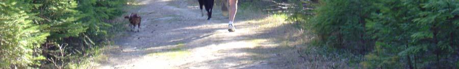
16 III. Users It is necessary to define the characteristics of users and the types of recreation activities in order to develop appropriate design standards and management practices for the trail. This trail system is primarily in wooded areas with hilly terrain. People enjoy these areas because of their natural environment and want to maintain those features. These areas currently attract outdoor enthusiasts with a range of physical abilities from families and seniors seeking less strenuous hikes to competitive athletes seeking challenging terrain. Public input indicated strong support for allowing a variety of non-motorized activities on the trail. Currently, the DNRC policies for recreation on State Trust Lands provide for multiple recreational uses but prohibit motorized vehicles, except for snowmobiles. Trail design will accommodate multiple uses and policies will promote management practices to minimize conflicts among activities. Community education regarding trail etiquette will be a critical strategy to maximize user experience. Specific types of activities on the trail include: 1) Hikers/Walkers According to the community survey, hiking and walking were the most popular activities on the State Trust Lands. Almost nine of ten people responded that they had hiked on these lands in the past year. Spencer Mountain was the most popular area for hikers followed by the Haskill and Beaver Lakes subareas. Hikers and walkers may also include activities such as walking with dogs, nature walks, bird watching, and wildlife viewing. 2) Mountain Bikers Of the non-winter sports, mountain biking was the second most popular activity with 68% of respondents engaging in this sport in the past year. Mountain bikers tended to be a slightly younger demographic than the general respondent to the survey. Spencer Mountain and Haskill subareas were the two most popular areas for the mountain bikers. I would like to see some of the trails be designated as family friendly where I could go with my family and have it be usable for biking or walking with my children. (Survey Comment) As long as everyone is aware that the trail is multiuse, and respectful of other users, there should be very little conflict. (Survey Comment) I go to places to get exercise, fresh air, and enjoy nature and a quiet place. Please don t pave it. Keep it natural (Survey Comment) Framework for Action - 4
17 3) Runners Runners accounted for 43% of the respondents to the survey. This group also represented a younger demographic than the general trail users. The Haskill area was the most popular spot for runners, followed closely by the Spencer Mountain subarea. 4) Equestrians Only 17% of respondents to the survey indicated that they currently use the trail for horseback riding. This group represented an older demographic than the average trail user. The Spencer Mountain and Beaver Lakes subareas were most popular with this group. 5) Cross Country Skiers Cross country skiing was the second most popular activity on the trails with 75% of respondents indicating that they had participated in this sport on State Trust Lands within the last year. Haskill Basin, Spencer Mountain and Beaver Lakes subareas were the most popular places for this activity. Beaver Lakes subarea offered groomed trails for cross country skiers. Cross country skiing in Beaver Lakes subarea 6) Snowmobilers Thirteen percent of respondents indicated they had been snowmobiling on State Trust Lands within the last year. This demographic was more likely to be male and more likely to have children under 18 living at home. Typically this group prefers groomed trails and consequently, the Swift Creek area is the most popular. The Beaver Lakes and Spencer Mountain areas also received use from this group. 7) Visitors & Commercial Outfitters In addition to the local population and Montana residents, outof-state visitors will use trail. Trail information for visitors will be at convenient locations. A commercial horseback operation is currently licensed in the Spencer Mountain subarea. Commercial outfitters for horseback riding and bicycle tours can significantly add to traffic on the trail and potential degradation of heavily used areas. The licensing procedures for commercial operations will address these management concerns. The trail may attract bicycle touring groups Framework for Action - 5
 signed a memorandum of understanding (MOU) to establish a recreational loop trail as generally described in the")
18 IV. Partnerships 1. Lead Agencies In October 2005 the City of Whitefish and Flathead Gateway Partners (FGP) signed a memorandum of understanding (MOU) to establish a recreational loop trail as generally described in the Whitefish Area School Trust Lands Neighborhood Plan. The parties agreed to work together to oversee development of the Master Plan and to process proposals through the DNRC and the State Land Board. In order to make joint decisions during the project and provide oversight to the planning process, the City of Whitefish and FGP each agreed to contribute two members to a four-member Steering Committee and one alternate member each. The Committee meets monthly and coordinates with public agencies that will be partners in implementing the Master Plan. The city will be the trail manager. 2. Project Partners Partnerships will be the key to realizing the trail vision. The Master Plan anticipates that multiple agencies will be involved in management, design, construction, and funding for the trail. Partnerships are necessary to create linkages with other trail networks in the area, to coordinate with other projects, and to create cost efficiencies. Following are partners that will be involved in implementing the Master Plan. Montana Department of Natural Resources and Conservation (DNRC) United States Forest Service Tally Lake Ranger District - Flathead National Forest Whitefish Fish Trails Flathead County Planning Department, Parks, Road Montana Fish Wildlife and Parks Montana Department of Transportation Big Mountain Resort Unites Sates Fish and Wildlife Service Private Land Owners Commercial Outfitters Framework for Action - 6

19 3. Coordination with Area Planning Efforts Whitefish Growth Policy Plan In June 2005 the Whitefish City Council adopted an amendment to the existing 2020 Master Plan to include the Whitefish Area School Trust Lands Neighborhood Plan. The city is currently developing a Growth Policy to be completed in early The neighborhood plan and trail Master Plan will be incorporated into this update. Whitefish Pedestrian and Bicycle Trails Master Plan The City of Whitefish has a Pedestrian and Bicycle Trails Master Plan that envisions construction of miles of asphalt and concrete paths within the general vicinity of the Whitefish community. "A Trail Runs Through It" trail system will interconnect with the Whitefish pedestrian and bicycle trail system. Flathead County Growth Policy Plan In June 2005 the Flathead County Commissioners adopted the Whitefish Area Schools Trust Lands Neighborhood Plan as a revision to the Flathead County Master Plan. The county is currently developing a Growth Policy that is scheduled to be completed in the fall of Once the growth policy is adopted, the Neighborhood Plan will be reviewed relative to the new growth policy. As part of the growth policy, the county is engaging in county-wide trail planning. "A Trail Runs Through It" project is being coordinated with this planning. Montana Department of Transportation The proposed trail alignment indicates that the trail will connect with the proposed pedestrian and bicycle trail being planned as part of the improvements to US 93 from Baker Avenue to west of Spencer Lake. A member of the Steering Committee is on the Citizen Working Group and will assist in coordinating the US 93 improvements with the "A Trail Runs Through It" project. The State of Montana is also completing a road reconstruction project on Big Mountain Road. The new road will be wider, have bigger shoulders and fewer curves. "A Trail Runs Framework for Action - 7
20 Through It" system is anticipated to interconnect with the Big Mountain Resort trail system through this road. Existing Easements & Licenses The DNRC manages a variety of leases, commercial licenses, and easements in the subareas that are included in the Whitefish School Trust Lands Neighborhood Plan. The trail system will be managed so as not to interfere with the operation of these existing uses and measures will be taken to minimize any potential conflicts. Examples of the existing uses include the following: Access and right-of-way easements Utility easements Grazing leases Timber leases Cabin leases Recreation licenses (horseback riding, snowmobiling, cross country skiing and dog sledding) Trapping License Firearm range and buffer zone USFS Flathead Forest The main trail corridor that surrounds the greater Whitefish area includes a segment of Flathead National Forest. A portion of the proposed main trail corridor will link the valley floor, State Trust Lands and the Flathead National Forest using the Taylor Creek Road, FS #9790. The Taylor Creek Road is a year-round open road that provides an access route to the Big Mountain Resort permit boundary. This portion of the trail will be subject to the United States Forest Service NEPA review process. Framework for Action - 8
21 V. Opportunities The planning process and Master Plan will be a model for other communities in the state. Developing the trail system will offer many opportunities to partner with other government agencies, non-profit, and private entities to form partnership for this project as well as future related projects. The trail system will create an outstanding recreational amenity for the community that will have economic spin-off effects through increased property values and increased tourism. The trail will offer an opportunity for community education on conservation values. The trail system will promote the recommendations of the Whitefish Area School Trust Lands Neighborhood Plan. Through the trail management agreement, there will be increased revenue for the state from better administration of recreational permits. Existing trails will be better managed to mitigate environmental impacts. The trail system will connect with other trail networks in the county to be part of a comprehensive countywide trail system. The trail system will promote fitness and a healthy lifestyle. The trail will have a variety of segments that can appeal to users with varying physical abilities. The trail will offer an opportunity to provide long term public access to the State Trust Lands. The trail system will offer opportunities to leverage resources and funds for other conservation efforts. Trail management will involve the various user groups as volunteers inspiring a sense of ownership of the trail. Framework for Action - 9
22 VI. Challenges Increased activity in the area from trail users might have negative impacts on the natural resources in the area. To reduce potential conflicts between different activities on the trail, there will need to be user education, coordinated enforcement with participating agencies, and a well developed set of policies and rules. Garbage disposal is a major concern for trail users. Parts of the trail system may cross private land and will require easements negotiations. Private land owners adjoining the trail have concerns regarding vandalism, litter, theft, erosion, and trespassing. Potential conflicts between user groups are more likely to occur at congested areas such as trailheads and popular trails close to town. Parking areas should be designed to minimize such conflicts. There should be better enforcement to curtail unauthorized motorized use and partying on the State Trust Lands. Recent logging activity in the Happy Valley area has diminished the aesthetic value of this area. This should be avoided in other areas where the trail is located. There will need to be coordination with the Montana Department of Transportation and Burlington Northern Santa Fe (BNSF) railway on pedestrian crossings. There are a number of recreation and transportation projects competing for the same funding sources. These efforts will need to be coordinated. Design standards and informational materials should incorporate safety concerns. Noxious weeds need to be controlled. Framework for Action - 10
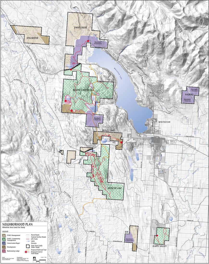
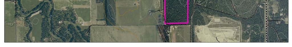
23 I. Overall Trail System The proposed recreational trail system will result in a trail network that includes a contiguous corridor connecting State Trust Lands per the Whitefish Area Trust Lands Neighborhood Plan (WATLNP), a system of secondary trails on these lands, and connections to nearby trail systems and recreation areas. Adjoining trail systems include the City of Whitefish Fish Trails network, Flathead County Bicycle and Pedestrian Trail System, USFS Flathead National Forest and Big Mountain Resort. Additionally, the trail will cross a limited amount of private land to connect the various segments of the trail. The trails are within or pass through the Spencer Mountain, Skyles Lake, Beaver Lakes, Swift Creek, Haskill, Happy Valley, and KM subareas. The map designates a main corridor and parking areas while the narrative for each segment generally describes issues, features and the system of secondary or adjoining trails that will connect to this corridor. The addition of secondary trails to this system will be based on recreation and conservation criteria. The secondary trail system will consist of some existing trails, trails that have been reconstructed for better functionality, and some new trails. Not all existing trails will be included in the system. There are existing trails that will be vacated due to poor design. A technical appendix includes an inventory of existing trails to be evaluated for this purpose. Looking at a map of the State Trust Lands The guiding principles (see Appendix) call for primarily singletrack, natural surface trails. Additionally, the map indicates proposed pedestrian and bicycle crossings at US 93 and at the BNSF railway right-of-way between the Beaver Lakes and Swift Creek subareas. The design, exact location, and easements for these crossings still need to be negotiated with the jurisdictional agency. The Master Plan also indicates the location and size of parking areas. The three subareas of Happy Valley, KM, and Haskill do not directly connect to the rest of the trail system. The plan identifies a trail system within each of these areas with recommendations that there be continued effort to explore the means to connect these areas to the other State Trust Lands. Trail System - 1


24 Trail System - 2
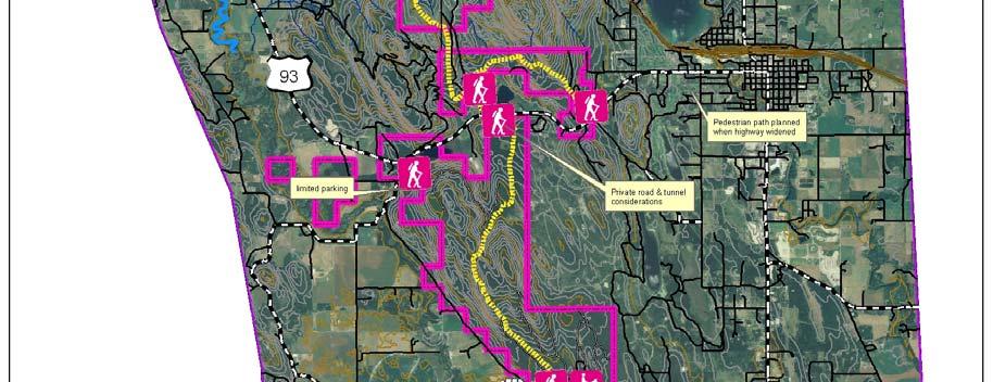
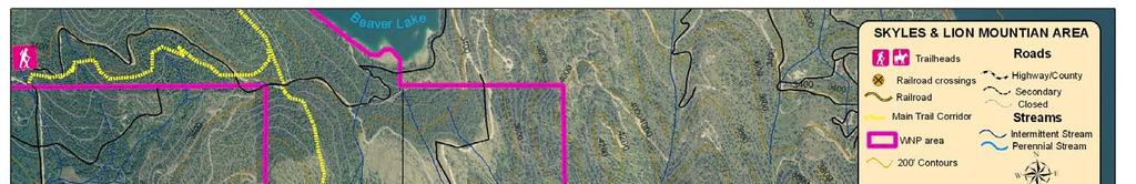
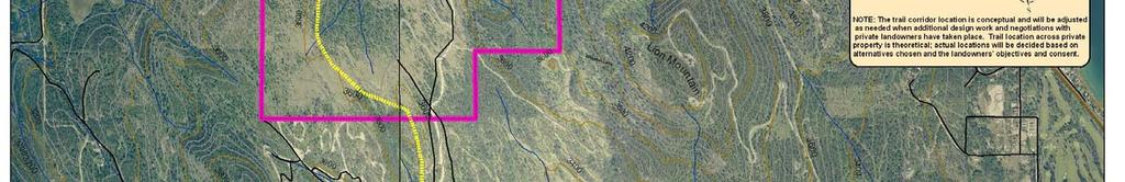
25 II. Lion Mountain Segment A. Subarea Description Lion Mountain is part of the Skyles Lake subarea. There is an informal trail network from Lion Mountain Road, which follows the ridgeline through the DNRC lands to private property. Using existing trails, a short 20 minute hike will lead to an overlook with views of Skyles Lake. This segment has some relatively steep grade but is used regularly by hikers, runners, and persons with dogs. It does not appear to have regular equestrian use. The trail network will benefit from improved drainage, erosion control, and switchback design in steep sections. B. Trail Usage View of Skyles Lake from Lion Mountain The trailhead in Lion Mountain is the closest access point to the City of Whitefish. Due to its proximity to town, this trail receives heavy use. It is popular with hikers, runners and persons with dogs. Illegal dumping, off-road motorized uses, and underage parties occurs in this area. A new trail along the southern edge of the subarea will have more gradual elevation gains and still offer views. The difficulty level will generally be classified as moderate with some segments that have steep pitches classified as difficult. Overall trail width may be wider than more remote areas due to the heavy use of this area. C. Access Points There is an existing trail off of Lion Mountain Road and a nearby gravel parking area that can accommodate about five cars. The plan recommends expanding this parking to accommodate ten to 15 cars. D. Main Corridor From the Lion Mountain trailhead, the main corridor will generally go west along the south part of the subarea to a bench where there are views of the Skyles Lake and Spencer Mountain subareas. From this point, a newly constructed trail will switchback a short way to the north portion of the subarea where it will continue west and descend down Lion Mountain to connect with the trail system in Skyles Lake. Rock outcropping in Lion Mountain Trail System - 4
26 E. Secondary Trail System There is an existing secondary trail system in this subarea. These trails will be evaluated to determine which trails are suitable to be included in the trail system. F. Linkages to Other Trail Networks Montana Department of Transportation is developing plans for improvements to US 93. The initial plans indicate a paved bike path along the north side of the highway from Whitefish to Spencer Lake. This bike path will be located less than a quarter mile from the Lion Mountain parking area. Bicyclists could depart from the Lion Mountain trailhead and exit at Skyles Lake Lane and head back into town along US 93 to form a loop ride. Existing trail in Lion Mountain G. Issues Due to heavy use, litter and vandalism can be a concern There is a history of illegal dumping in this area Private residences are near parts of the trail, so user education and enforcement of trail rules are important Illegal dumping of yard waste Trail System - 5
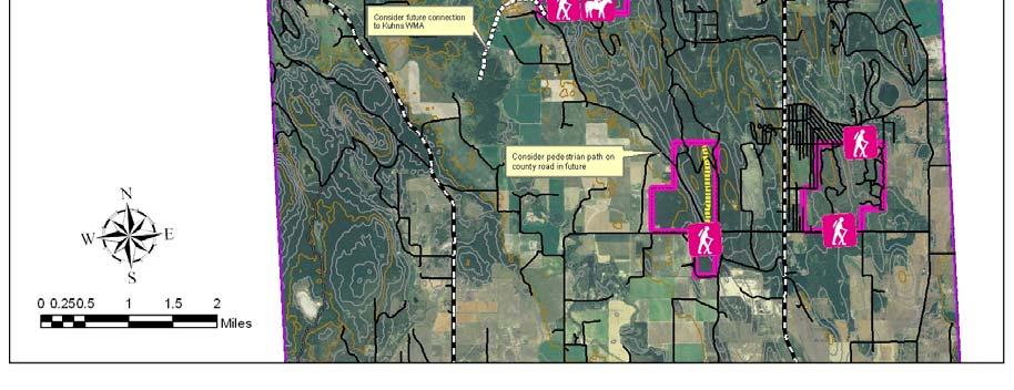
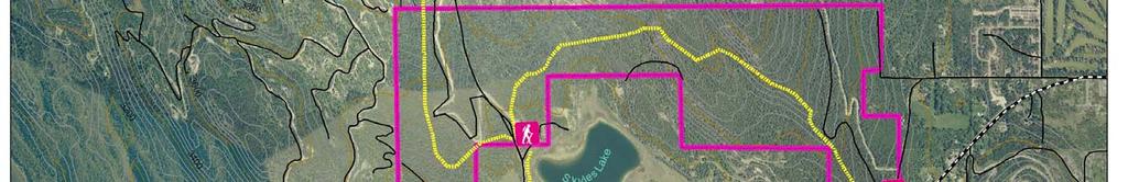
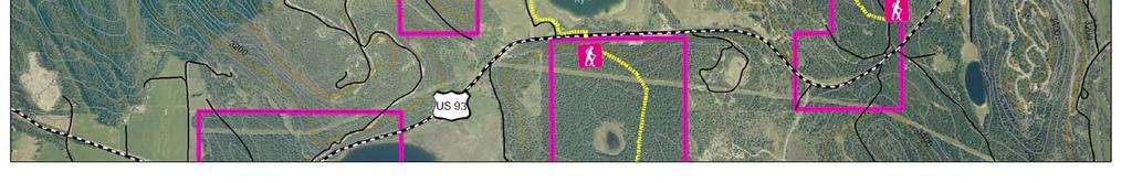
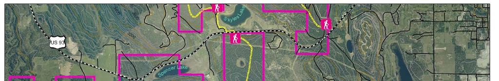
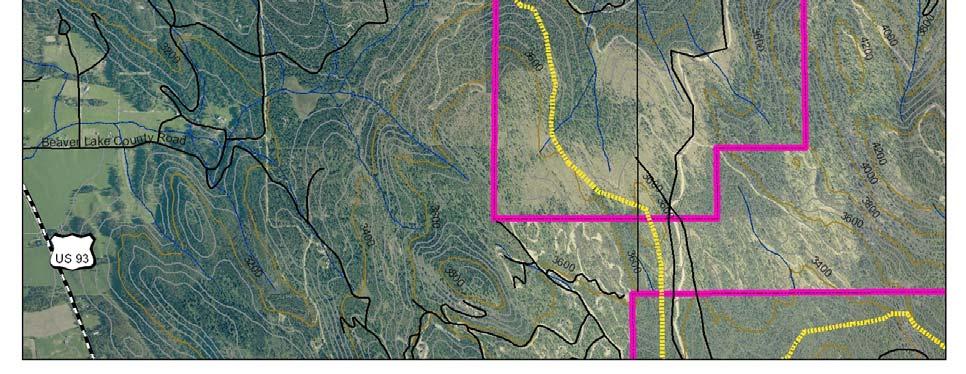
27 III. Skyles Lake Segment A. Subarea Description The Skyles parcel consists of approximately 600 acres in a U- shape around Skyles Lake. Access to the west side of Skyles subarea is from US 93. The lake is visible from the highway. Skyles Lake is surrounded by a large number of private parcels, both developed and undeveloped. Along US 93, the residential development has smaller lots and higher density. Going north along Skyles Lake Lane, there are five, ten, and 40 acre residential lots. Within the Skyles Lake area, 7.38 acres are leased for residential purposes to three lessees. B. Trail Usage The west access point will attract multiple groups such as bicyclists, equestrians, runners, hikers, and walkers. Bicyclists will likely share Skyles Lake Lane with auto traffic that is driving to the existing parking area. Hikers, walkers, and equestrians will be more likely to drive to the parking area and head north from this point. Due to its close proximity to the City of Whitefish, it is anticipated that this will be a high use area. Trails will vary from easy to moderate. C. Access Points There is an existing parking area with space for about 20 vehicles and possibly a few horse trailers. This parking area will require little improvement from its existing configuration. D. Main Corridor The main corridor will begin at the south end of this sub-unit at US 93. It is proposed that a pedestrian underpass be constructed to connect the Skyles Lake subarea to the Spencer Mountain subarea near Skyles Lake Lane. This gravel road is a private road but public access is allowed for the first one-half mile to an existing parking area located on State Trust Land. There is currently a gated road that provides access to an adjacent landowner and DNRC. In a reciprocal access agreement, there is no public motor-vehicle access north of the gate other than use by private landowners and state landmanagement personnel, but bicycle and pedestrian access is allowed. The trail is proposed to be re-routed and fully reconstructed off of the road through this area. This section of Skyles Lake subarea parking area Trail System - 6
28 trail will head north crossing DNRC and private lands until it reaches the Beaver Lakes Road. E. Secondary Trail System There are limited secondary trails in this part of the subarea. F. Linkages to Other Trail Networks Montana Department of Transportation is developing plans for improvements to US 93. The initial plans indicate a paved bike path along the north side of the highway. This bike path will provide access to Skyles Lake Lane and the proposed pedestrian underpass to access the trail system in the Spencer Mountain subarea. G. Issues Confirm public access on Skyles Lake Lane and work with the county to designate it as a bicycle route Work with Montana Department of Transportation to construct pedestrian underpass Work with private land owners in area on specifics for trail design and alignment Gate on Skyles Lake Lane Trail System - 7
29
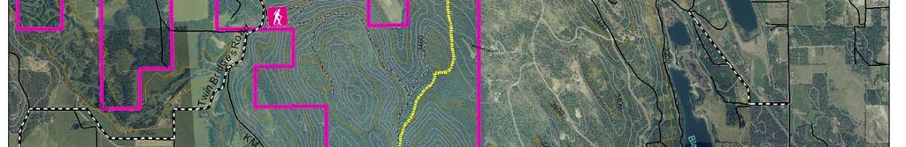
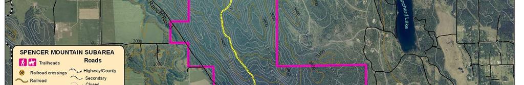
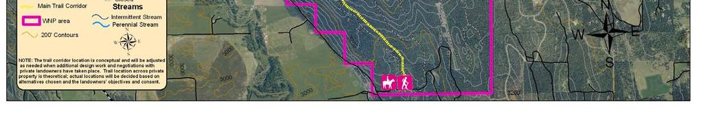
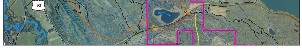
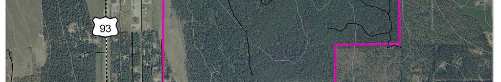
30 IV. Spencer Mountain Segment A. Subarea Description The proposed trail in the Spencer Mountain subarea passes through a parcel that encompasses approximately 2,740 acres and is located south of US 93. This subarea is surrounded by a large-lot Whitefish Hills subdivision to the east, the US 93 corridor on the north, and a mixture of large and small lot parcels intermingled with open agricultural lands on the west and south. Spencer Mountain is steep with many slope gradients in excess of 25 percent. Besides the lake, the area is fairly dry with good soil drainage. The southern portion of Spencer Mountain is less steep, has rolling terrain, and provides expansive views to surrounding areas. Spencer Mountain is frequented by a variety of wildlife. The western portion of this land lies within the whitetail deer winter range. Trail in Spencer Mountain B. Trail Usage Spencer Mountain is popular for a variety of recreational uses, including mountain biking, running, hiking, hunting and fishing, horseback riding, cross-country skiing, snowshoeing, and unauthorized motorcycle and ATV use. Commercial equestrian outfitters have a permit to operate in the area. The trails in this area will have a difficulty level of moderate to difficult for pitch and tread but will require wider trails near the trailhead to accommodate multiple uses. C. Access Points Twin Bridges - There is an informal trailhead providing public access to Spencer Lake at US 93 and Twin Bridges Road. The existing parking area can accommodate five to six cars. A curve in the road creates site distance visibility issues and this parking area needs to be redesigned. The map indicates continuing the use of a small parking area with the primary purpose of providing access to the lake. South - A new parking area is proposed for the south end of the Spencer Mountain subarea. There is an existing DNRC dirt road off of KM Road that currently serves the rifle range. The parking area will be located to the east of the rifle range. This area is flat with new growth in an area that was previously clear cut. The parking area will be large enough for 11 to 30 cars plus additional room for five Twin Bridges parking Trail System - 9
31 to ten horse trailers. Parking for horse trailers will be designated to avoid conflicts with other user groups. North - A new parking area is proposed for the north side of Spencer Mountain at approximately mile marker 131 on US 93. There is a flat, wooded area at this location but the steep grade behind flat spot limits the size of the parking area. Consequently, this parking area bill be located at the top of the hill about 100 to 200 yards from the highway. It will be a small to medium size area to accommodate ten to 20 cars. Horse trailers will not be permitted due to size limitations and traffic on US 93. The map shows a bike path connecting this parking area to the proposed pedestrian underpass on US 93. Possible location for parking area off of US 93 D. Main Corridor The trail will generally travel north and south connecting the two main access areas. The trail will be a combination of existing and new trails. The trail climbs in elevation from each parking area to reach a high point in the middle of the unit. E. Secondary Trail System An extensive network of trails exists, some utilizing old roadbeds but more being of the narrow single-track variety. Almost all trails have been pioneered by various user groups and there are a number of unauthorized stunt features in the area. These trails will be evaluated to determine which are suitable for the trail system. There could be a designated bike jump/stunt feature area to replace these trails. F. Linkages to Other Trail Networks A proposed pedestrian underpass will connect the Spencer Mountain subarea to the proposed bike path on US 93. G. Issues Unauthorized bike trail and stunt feature in Spencer Mountain Motorized use requires enforcement of rules Unauthorized trails will be evaluated Illegal bicycle stunt features will be evaluated and possibly removed Twin Bridges parking area will be redesigned Determine if the pedestrian underpass should be designed for horses Trail System - 10
32

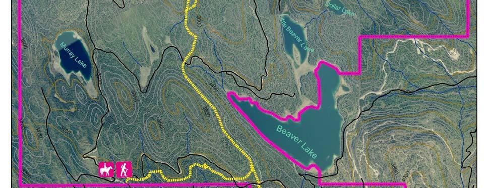
33 V. Beaver Lakes Segment A. Subarea Description The Beaver Lakes subarea consists of approximately 4,210 acres and stretches from Boyle Lake, near the north end of Whitefish Lake, south to the Skyles parcel, just north of US 93. With great scenic beauty, the varied terrain of the Beaver Lakes parcel includes cliffs, ridges, benches, potholes, and six lakes in a relatively remote and pristine mountain environment. The primary access to the Beaver Lakes subarea is via a county road from US 93 to the southwest corner below Beaver Lakes. The Beaver Lakes and Skyles parcels are surrounded by a large number of private parcels, both developed and undeveloped. There are 20 residential leaseholders in the Beaver Lakes subarea. Currently, DNRC manages the area for timber, as well as a number of recreation licenses. The lakes have good floating, easy shoreline access, and ice fishing in winter. There are some unauthorized camp sites and trails in the subarea, although not as extensive as in the subareas closer to town. The Beaver Lakes subarea is popular for fishing and water recreation Due to its large size and high and remote qualities, the area provides habitat for a variety of species, including critical winter range for elk, mule deer, and whitetail deer. Grizzly bears presently use and are expected to continue to use these areas. Loons consistently use Beaver, Little Beaver, and Murray lakes. B. Trail Usage Recreational uses in the subarea include mountain biking, running, hiking, hunting and fishing, wildlife viewing, horseback riding, cross-country skiing, backcountry skiing, snowshoeing, snowmobiling, and water activities. Beaver Lakes trails experience relatively heavy use from multiple activities. The difficulty level in terms of tread and pitch will be moderate but the width will need to be wider to accommodate multiple uses. Some short segments or spur trails may be rated as difficult. Existing trail in Beaver Lakes subarea Trail System - 12
34 C. Access Points There is an existing parking area approximately 1.5 miles from US 93. The gravel road that leads to the parking area is a county road. The parking area is a semi-circle configuration that can accommodate approximately 15 cars. There is a trail kiosk at this area with a map of the Beaver Lakes complex. The parking area will be expanded to accommodate up to 30 cars and a designated area for up to five horse trailers. D. Main Corridor From the trailhead at the parking area, a new trail will be constructed heading east to connect with the main trail coming from the Skyles Lake subarea. At this juncture, the trail will head north through a heavily wooded area generally following an existing trail. This existing trail system is not well-defined and may require some new construction and widening to accommodate new trail usage. As the trail continues north, it gains elevation and there are opportunities for spur trails that can offer excellent views of the Whitefish Range and Whitefish Lake. After reaching this scenic overlook, the trail descends and exits the Beaver Lakes subarea at the BNSF railway tracks. Options for crossing the railroad are discussed in the section on the Swift Creek subarea. E. Secondary Trail System There are some unauthorized trails in this subarea, although not as extensive as in areas that are closer to town. There is also significant day-use around the lakes. The Whitefish School Trust Lands Neighborhood Plan recommends that a recreation plan be completed for the Beaver Lakes complex. A secondary trail system and other recreation amenities can be explored as part of this planning process and included into management of the trail system. Beaver Lakes parking area View of Whitefish Range from Beaver Lakes subarea F. Linkages to Other Trail Networks This trail system will link to the trail networks in the Skyles Lake and Swift Creek subareas. G. Issues Development of a recreation plan for the entire Beaver Lakes complex will be coordinated with the trail system. Licenses for commercial recreation uses are issued for a variety of activities Trail System - 13


35
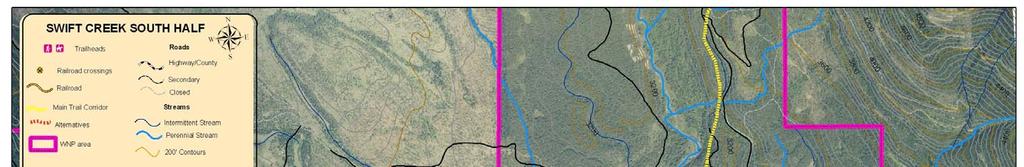
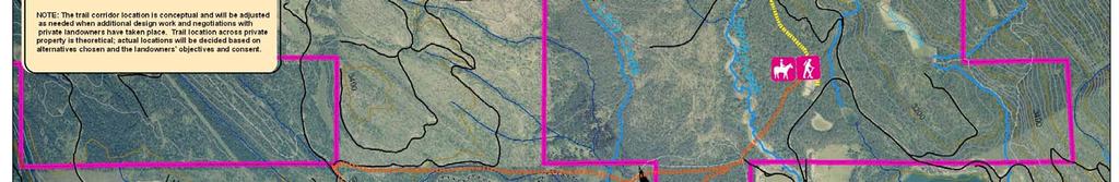
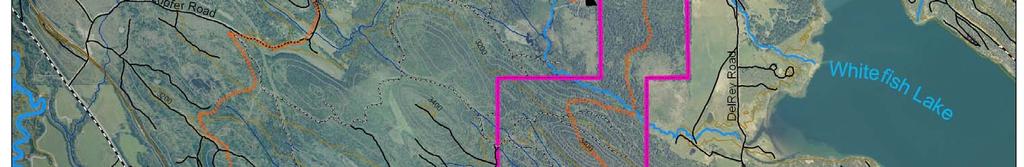
36 VI. Swift Creek South Half & Adjoining Properties A. Subarea Description The Swift Creek subarea is 2,930 acres and is located at the north end of Whitefish Lake and north of the Beaver Lakes subarea. For purposes of this plan, the area has been divided into south and north sections. The south half is bordered by the BNSF railroad tracks to the south and includes section 7 and section 6 in T31N, R22W. Dominant features of this area include Lazy Creek and Boyle Lake. Both of these water features have associated wetlands with marshy areas and aquatic plants. The topography of the area ranges from relatively flat, rolling bottom lands associated with large riparian areas, to ridges overlooking these features. Higher elevations in the south half are well-drained with dense forest. The diverse habitat in the area is occupied and utilized by many species of wildlife, including big game, a wide range of song birds, and large and small forest carnivores. Lazy Creek Adjoining private land to the west of this area is a combination of larger land owners with some smaller parcels. There may be opportunity to negotiate with these owners to allow a portion of the trails to pass through their properties. These lands include forested areas as well as a potential crossing for Lazy Creek. B. Trail Usage This portion of the State Trust Lands is remotely located and receives the lowest volume of recreational use. Hikers, bicyclists, and equestrians will likely use this area. This trail will be rated at a difficulty level of easy to moderate pitch with generally a narrower width. Trail amenities will be more primitive in nature. C. Access Points This trail will connect with the trail system in the north half of the Swift Creek unit and the Beaver Lakes subarea. Three potential crossings of the BNSF railroad were considered to connect the trails in Beaver Lakes and Swift Creek subareas. The three alternatives are described below. After field evaluation, Options B and C were determined to be the preferred alternatives. Further analysis on the feasibility of Marsh area near Lazy Creek Trail System - 15
37 each crossing and discussions with the BNSF railroad is necessary prior to making a final decision on the crossing. Option A - This option will include a multiple use nonmotorized tunnel at Del Rey Road in the vicinity of the existing at-grade crossing that is currently used for BNSF railway operations. (The crossing is not currently open to the public and an at-grade crossing for the trail will not be permitted by BNSF Railway.) This was not a preferred alternative because of difficulties with locating a path in the Del Rey Road right-of-way. Option B - In this alignment, the trail will cross the railroad just east of Boyle Lake. Due to high groundwater in this area, an underpass-tunnel is not feasible and an overpass will be necessary to allow trail users to cross the railroad. The land on both sides of the railroad tracks at this location is feet higher than the tracks. There is an abandoned railroad tunnel at this location. It may be possible to take advantage of this grade change by building a pedestrian bridge spanning the embankments on both sides of the railroad without having to construct lengthy approach ramps. The trail will exit the north side of the tracks on a ridge above Boyle Lake avoiding the wetland area and offering views of the lake. Option C - In the Beaver Lakes subareas the trail will follow the railroad tracks going west. There will be a minimum 100 feet separation from the tracks. The trail will cross the railroad tracks on State Trust Land at the northwest corner of the Beaver Lakes subarea. There is an old railroad bed that is about 20 feet below grade of the railroad. This could be extended as a pedestrian tunnel under the railroad tracks. Option B Potential crossing for pedestrian overpass D. Main Corridor The main corridor will connect the trail where it crosses the railroad parking area in the north half of the Swift Creek unit. The trail will need to cross both Lazy Creek and Swift Creek. There may be a possibility to use an existing bridge on private property to cross Lazy Creek. This will require negotiations with the private land owner. Either of the railroad crossings will allow several options for routing the trail. Potential trail routes need to be further evaluated in the field and by technical specialists to determine the optimum route. Additionally, the Option C Old rail bed below railroad grade that could lead to pedestrian tunnel Trail System - 16
38 final alignment will depend on negotiations with private land owners. Some possible options and considerations for trail routes include: Option 1 From crossing B, follow a ridge along the east side of Boyle Lake and connect with an old railroad bed that follows Lazy Creek along the west side. Follow this rail bed for a period then switchback up an old logging road on a ridge above the creek. Follow the ridge northerly to a private road and head east to existing bridge that has a crossing over Lazy Creek. This will require negotiating with private land owner. Option 2 From crossing B drop down the ridge and cross Lazy Creek on State lands. Head east to Swift Creek. This will require going through wetlands and building a boardwalk. Option 3 From crossing C, continue west paralleling the railroad tracks through private property to an access area off of Lupfer Road. The trail will circle back to the existing bridge crossing at Lazy Creek. Some of this land is being considered for a land exchange with DNRC. If another alignment is selected, an independent trail system for this land may be possible. If the existing crossing at Lazy Creek is not feasible, then any new crossing will need to consider a route and trail design that will have minimum impact on the wetland areas around Lazy Creek. There are multiple alignments that are not described. Further field work will is needed to evaluate all of these options. Once across Lazy Creek, the trail will generally head east to a new crossing at Swift Creek. The location of this crossing at Swift Creek is still to be determined. E. Secondary Trail System The area does not receive heavy use and the number of secondary trails is limited. Such trails will be kept to a minimum due to the sensitive wetlands and wildlife habitat in the area. Road on ridge above Lazy Creek F. Linkages to Other Trail Networks This system will link to other trails on DNRC Land. Trail System - 17
39 G. Issues The location of the railroad crossing needs additional analysis to determine the engineering requirements and costs. Additionally, there will be consultations with BNSF Railway representatives to determine their preferences for location and design. Negotiation for a crossing easement over or under the railroad will be required. Some challenges to overcome in order to allow horses to cross the railroad include safety and expense. There may be safety issues due to horse behavior in a confined space during a time when a train is crossing the tracks. A board walk type trail or turnpike trail used in wet areas can cost from ten to thirty times as much as natural surface trail construction. The cost will be even higher if getting equipment and supplies to the site is restricted by wet areas. Additionally, maintenance of this type of trail is costly, and there are some restrictions in wet areas to not use treated timbers. It is likely that a higher level of environmental analysis and permitting will be required to construct a trail in a wetland area. Putting the trail upslope of wetlands reduces environmental impacts, minimizes degradation of wildlife habitat, and will not require additional permit analysis. The portion of the trail that is west of the Swift Creek unit may involve negotiations for easements with multiple private property owners. Trail System - 18
40
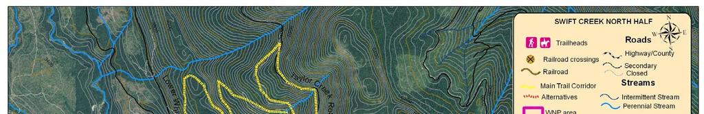
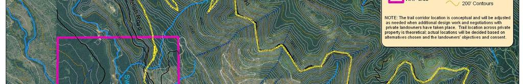
41 VII. Swift Creek North Half A. Subarea Description Primary access to the area is via Del Rey Road, a county road, and Lower Whitefish Road, a primary open road on Stillwater State Forest. Dominant features of this area include Lazy Creek, Smith Lake Reservoir, and Swift Creek, a major tributary of Whitefish Lake. The area is characterized by densely stocked forestland. Much of the forest consists of mature mixed-conifers stands with considerable structural diversity and lush shrub and forb understories. The topography of the area ranges from riparian areas to steep well-drained southwestern aspects located on the lower slopes of the Whitefish Range. Elevations range from 3,200 to 5,000 feet, a span of approximately 1,800 feet. The diverse habitat in the area is occupied and utilized by many species of wildlife, including big game, a wide range of song birds, and large and small forest carnivores. The northern portion of the subarea is within the recovery zone of the Northern Continental Divide Ecosystem for grizzly bears and is outside of the study area of the Whitefish School Trust Lands Neighborhood Plan. Swift Creek B. Trail Usage The north Swift Creek area experiences heavy recreational use that includes mountain biking, hiking, fishing, wildlife viewing, horseback riding, cross-country skiing, backcountry skiing, snowshoeing, snowmobiling, hunting and various water activities. In the winter, trails are groomed for snowmobiles. Trail difficulty will be moderate with some segments possibly being difficult due to steep grade. C. Access Points The Lower Whitefish Road is a main access connection between Upper Whitefish Lake and Whitefish Lake, as well as a route to Werner Peak Lookout, Red Meadow Lake, and the North Fork of the Flathead River Basin. A winter trailhead and parking area is located in the Swift Creek subarea at the Del Rey Gravel Pit. This trailhead is used extensively for access to the groomed snowmobile trails on the forest by residents and commercial snowmobile operations. There is a large parking area that already accommodates cars and snowmobile trailers. The gravel pit will be reclaimed and added to the parking area within several years. Del Rey parking area Trail System - 20
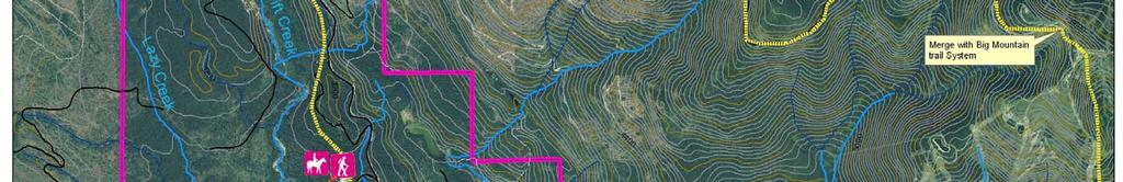
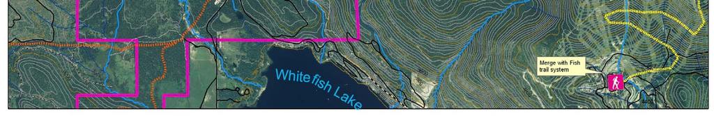
42 D. Main Corridor The main corridor will generally head north from the Del Rey gravel pit for one and a half miles to a connection with an existing Forest Service road. The trail on State Trust Land will be a newly constructed trail that will parallel some existing logging roads. The grade is level for the south portion of the trail but will have a significant elevation gain as it approaches the connections with the Forest Service trail. E. Secondary Trail System The secondary trail system in this subarea will be evaluated to determine which trails are suitable for being included in the trail system. There should be minimal disturbance in the grizzly bear recovery area. Old road near Swift Creek F. Linkages to Other Trail Networks This trail will link with Forest Service land and the Taylor Creek Road area. The city s Fish Trail network designates part of East Lake Shore Drive as a bicycle route. Further investigation on the construction of a bike path along this road to connect with the Del Rey parking area is recommended. G. Issues Coordinating connections with other trail networks Minimizing wildlife impacts Locating an appropriate crossing on Swift Creek See previous section for discussion on wetlands Part of the area is in the US Fish and Wildlife Service northern continental divide ecological system for grizzly bear recovery. East Lake Shore Drive is narrow and winding - a future off-road bike path will be safest option for traffic on this road Trail System - 21


43 VIII. USFS Taylor Creek Rd. Big Mountain A. Subarea Description United States Forest Service land is adjacent to the north half of the Swift Creek subarea. This is heavily forested land with significant elevation gains. It has high wildlife and natural resource value. B. Trail Usage Presently, bicyclists can ride up the Taylor Creek Road to the gate located at the saddle and then back down. Downhill bicyclists are not allowed to exit the Big Mountain Resort using the Taylor Creek road due to a Forest Service special order closure. Taylor Creek road is currently an open road for motorized use and part of a groomed snowmobile system. View from Big Mountain C. Access Points The Taylor Creek road is a year round open road that provides an access route to the Big Mountain permit boundary. Bicyclists and hikers could access the trail at the summit of Big Mountain Resort. D. Main Corridor A portion of the proposed main trail corridor will link the valley floor, State Trust Lands and the Flathead National Forest using the Taylor Creek Road, FS #9790. The Flathead National Forest proposes to re-consult with the US Fish and Wildlife Service on allowing downhill mountain bike traffic to leave the permitted Big Mountain Resort boundary using the Taylor Creek Road. The trail route will use the existing Taylor Creek road located in T32N R22W SECs 17, 20, 21, 28, 27, 26, and 25. In Section 17, the trail corridor exits the Taylor Creek Road onto a closed FS #9868 road for approximately two miles, then the trail travels onto State Trust Lands. Hikers on Danny On Trail E. Secondary Trail System There are currently no secondary trails in this area. Secondary trails will only be allowed subject to Forest Service review and regulations. Trail System - 22
44 F. Linkages to Other Trail Networks Big Mountain Resort has mountain bike trails that will link to this network. Bicyclists will ride down Big Mountain Road to connect with the city s Fish Trail network. The State of Montana is completing a road reconstruction project on Big Mountain Road. The new road will be wider, have bigger shoulders and fewer curves. Plans call for a realignment of utilities in 2006 with final road construction taking place during the summer of G. Issues The connection between Taylor Creek Road and Big Mountain Summit will need approval from US Fish and Wildlife service due to grizzly bear recovery concerns. Mitigation may be necessary to allow bike riders to exit the chair lift to Taylor Creek Road. There is potential safety conflicts between motorized users and bicyclists on the road. Trail System - 23
45
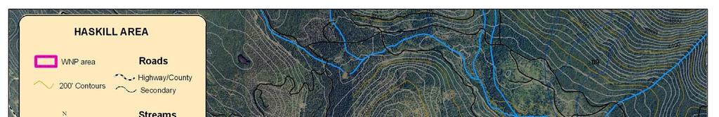
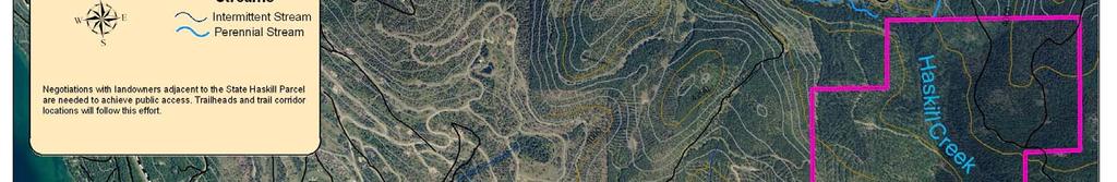
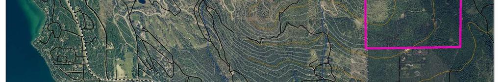
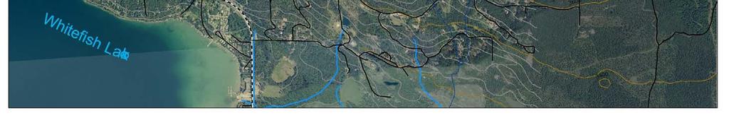
46 IX. Haskill Subarea A. Subarea Description The Haskill subarea contains approximately 520 acres of land in the undulating foothills of the Whitefish Range. Located about three and one-half miles from town, it is one of the closest areas to the City of Whitefish. Haskill Creek bisects the parcel and is a primary source for the city's municipal drinking water. Grizzly bears roam the sensitive wildlife habitat in the spring and fall, and elk, deer, mountain lion, coyote and other forest dwellers are seen year round. There are rolling trails with beautiful views of Haskill Basin and Micho Ridge. It is managed for timber. B. Trail Usage This area is popular with runners, hikers, mountain bikers, horseback riders, hunters, cross-country skiers, and other recreationists. It does not get heavy use from non-residents. Trail difficulty levels will range from moderate to difficult. Trail in Haskill subarea C. Access Points There is no parking area to access the trails and the area does not have access from public roads. Current access is from private roads or adjoining public and private forest lands. It is recommended that there be continued communication with the property owners to locate a parking area for the subarea. D. Main Corridor & Secondary Trail System The trail system is being inventoried in order to evaluate trails for the best system of main and secondary trails. F. Linkages to Other Trail Networks There is an informal system of trails on adjoining private and public forest lands that connect with this area. Iron Horse subdivision has a bike path that connects with parts of this private forest land. The City of Whitefish Fish Trails system may be a future connection. G. Issues Providing public access Trail System - 25
47
48 X. Happy Valley Subarea A. Subarea Description The Happy Valley subarea is approximately 480 acres in size and contains relatively flat, timbered land interspersed with a few small meadows. The area has a high water table and poor drainage. To the north and west are one-half to one-acre residential properties, including some areas zoned R-2 that permit half-acre sites. To the east are larger lots of five to ten acres in size. To the south are large, predominantly undeveloped agricultural and forestry parcels. The Happy Valley subarea is heavily timbered and provides a variety of wildlife habitat, including whitetail deer winter range. The site is managed for timber sales. Happy Valley B. Trail Usage This parcel of State Trust Lands has historically provided open space, recreational trails, and access opportunities for the surrounding community. Neighborhood residents use the land for running, biking, horseback riding, hiking, cross-country skiing, unauthorized ATV use and snowmobiling. Trails types include roads, overgrown skid trails, and single track trails. In some instances, this heavy recreational use resulted in negative impacts from unauthorized motorized use, vandalism, eroded trails, and trash. Trail difficulty will range from easy to moderate. C. Access Points Happy Valley is accessed from US 93 and is bounded by Bowdish Drive, Meadow Lane, Elk Trail, and Primrose Lane; all county roads. There is a small parking area on Bowdish Drive and this will be improved to accommodate five to ten cars. There are also access points from streets bordering Happy Valley. Bowdish Drive Parking Area D. Main Corridor A main corridor will provide a loop trail within the subarea. Trail System - 27
49 E. Secondary Trail System There are many secondary trails in this subarea. These trails will be evaluated to determine which trails are suitable for being included in the trail system. F. Linkages to Other Trail Networks Currently, this subarea does not link to the rest of the trail network. Potential future connections will be through paved bike paths on county or state roads such as US 93 or Whitefish Stage Road. Currently there are no plans for such connections. Proposals for such bike plans will need to be coordinated through Flathead County as part of their trail planning process. G. Issues Recent (2005) timber harvest related activities have destroyed many of the trails in this parcel of land. The presence of slash piles and many kelly humps and large pits have severely degraded the trail system in Happy Valley. Roads used for logging were widened with staging areas that now have compacted soils and are devoid of vegetation. Final phases of the logging project will include burning slash piles, cleanup and tree planting. Neighborhood residents are working with DNRC to develop a plan to re-vegetate damaged areas and reestablish trails. Kelly hump on trail in Happy Valley Trail System - 28


50
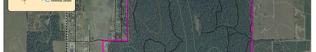
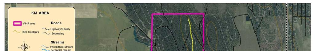
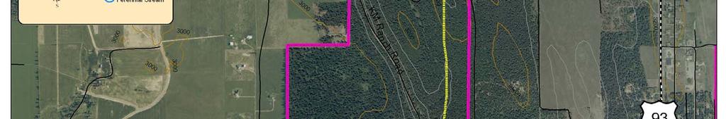
51 XI. KM A. Subarea Description The KM subarea is a 480 acre timbered area bisected by KM Ranch and Spring Prairie roads; both county roads. The KM area is surrounded by a variety of large and small private parcels that are interspersed with timber and agricultural lands. The eastern portion of the parcel consists of rolling timberland. Much of the timber is dog-hair lodgepole pine. The west side is timbered and bordered by rural landowners, a trap-shooting range, and the county landfill. Whitetail deer and other wildlife frequent the area. The KM area is used primarily for timber production. The land is currently leased for grazing (165 acres), agriculture (five acres), and residential (five acres) uses. B. Trail Usage The public uses old logging roads and skid trails that are accessed from KM Road for recreational activities including mountain biking, hiking, gun club use, hunting, horseback riding, cross-country skiing, backcountry skiing, snowshoeing, wildlife viewing, and snowmobiling. A number of old logging roads are frequented by trail users and unauthorized fourwheelers. Most users live in the vicinity of the area and it does not receive heavy usage compared to areas closer to town. Trails in this area will be moderate in difficulty level. C. Access Points Currently, there is no formal parking area serving this area although there is room for a few cars to park near Spring Prairie Road. This area can be expanded to a parking area and formal trailhead with space for five to ten cars. Parking area near Spring PrairieRoad D. Main Corridor A main corridor will provide a loop trail within the subarea. Trail System - 30
52 E. Secondary Trail System There is an existing secondary trail system in this subarea. These trails will be evaluated to determine which are suitable for the trail system. F. Linkages to Other Trail Networks Currently, this subarea does not link to the rest of the trail network. Potential future connections could be made by designating KM Ranch Road as a bicycle route where bicyclists share the roadway with motor vehicles and signs are posted along the route. KM Ranch Road is a low-volume gravel road from the KM subarea to the south end of Spencer Lake. Flathead County has jurisdiction of KM Ranch Road and will be the entity to make this bicycle route designation. G. Issues Connect this area to the remainder of the trail system Rules for unauthorized motorized use need to be enforced Unauthorized road for motorized use in KM sub area Trail System - 31

53
54 CHAPTER 4: Trail Design Trail Design - 0
55 I. Applicability of Design Standards 1. State Trust Lands The majority of the trails in A Trail Runs Through It system will be located on the Montana Department of Natural Resources School Trust Lands. These trails will be primarily multi-use trails with a natural surface. The design guidelines in this chapter apply to these trails. 2. United States Forest Service A portion of the trail system will include trails on the Flathead National Forest. Specifically, this will include a link from the summit of Big Mountain Resort following Taylor Creek Road to connect with the trail system in the Swift Creek subarea. This trail and any future trails on Forest Service Land must follow the design standards and specifications of the United Sates Forest Service. Trail in Spencer Mountain subarea 3. Public Right-of-Way This Master Plan describes a trail system that links with proposed bike paths in the City of Whitefish and along US 93. These are off-road paved bicycle trails that generally follow standards established by the American Association of State Highway and Transportation Officials. (AASHTO). Additionally, there may be some linkages to designated bike routes along county and city roads. On these routes, bicycles share the roadway with vehicles and there may be signage alerting motorists to bicycle traffic. Whichever local government has jurisdiction of the road will designate the bicycle route and determine the standards for these roadways. 4. Private Property Fish Trails in Whitefish Trails that cross private property through an easement for the A Trail Runs Through It project would follow the same design standards as the trails on State Trust Lands unless the easement provided otherwise. The trail system may also connect to privately operated trails such as the mountain bike network at Big Mountain Resort. The property owner will establish the design standards for these trails. Trail Design - 1
56 II. Difficulty Levels The physical design of the trail will vary depending on the natural features, volume of traffic on the trail and the types of activity. Heavily congested areas will be designed for ease of use until the trail users have an opportunity to disperse. Trails that are in more remote areas can be more challenging. Additionally, trails that are attractive for a wide range of users will have a wider and more even grade to avoid conflicts. The International Mountain Bicycling Association (IBMA) has a rating system that is adapted from the difficulty rating system used at ski resorts. Although the ratings are developed for mountain bike trails, they are also useful for other activities such as hiking and horse back riding. The system focuses on technical challenge, not physical exertion. The following trail features determine technical challenge: Trail width Tread surface Average trail grade Natural obstacles and technical trail features The IBMA has five ratings from Easiest (paved trails) to Extremely Difficult (the equivalent of a double black diamond at a ski resort). The design guidelines for A Trail Runs Through It will be for natural surface trails using the three IBMA middle rankings for level of difficulty. ( Easy, Moderate, and Difficult ). Guidelines for classifying different segments of the trail include: Survey Responses 83% agreed the trail should be a natural surface. 78% agreed some segments of the trail should be family friendly. 77% agreed some segments of the trail should be strenuous /challenging. 63% agreed some segments of the trail should accommodate disabled users. Trail segments near trailheads should be Easy High activity corridors should be Easy The overall difficulty level for the remainder of the main corridor should be Moderate Depending on natural features, there may be short segments that would be either Easy or Difficult. Chapter 3 generally describes the difficulty level for each subarea of the trail Some secondary trails or spurs may be specifically designated for family, seniors, or disabled populations and designed as Easy Some secondary trails or spurs may be specifically designated as challenging and be designed as Difficult 71% said it was very important to post trail rules at trailheads. 76% agreed the trail should accommodate mountain biking. Trail Design - 2
57 Table 1: Trail Difficulty Rating System EASY MODERATE DIFFICULT Trail Width 72 inches or more 36 inches or more 12 inches or more Tread Surface Firm and stable Mostly stable with some variability Widely variable Average Trail Grade 5% or less 10% or less 20% or less Maximum Trail Grade 15% Max 15% or greater Max 15% or greater Natural Obstacles and Technical Trail Features (TTF) Unavoidable obstacles 2 or less Avoidable obstacles may be present Unavoidable bridges 36 or wider Unavoidable obstacles 8 tall or less Avoidable obstacles may be present Unavoidable bridges 24 or wider Unavoidable obstacles 15 tall or less Avoidable obstacles may be present May include loose rock TTF 2 high or less, width of deck is greater than ½ the height Unavoidable bridges 24 or wider TTF 4 high or less, width of deck is less than ½ the height Short sections may exceed criteria Source: International Mountain Bicycling Association, Trail Solutions IBMA s Guide to Building Sweet Single-Track Trail Design - 3
58 III. Construction Standards 1. Benefits of Proper Construction Trail construction activities include clearing, grading, installing drainage improvements, speed control features, and building trail structures. Common trail features that need to be constructed include climbing turns, switchbacks, culverts, bridges, boardwalks, crossings, rock walls, retaining walls and signs. Proper trail design and construction techniques have many benefits such as: Lowering maintenance costs Lessening impact on the environment Resisting erosion Improving water quality Reducing negative impacts on wildlife Blending in with surrounding area Creating an enjoyable and safe experience for trail users Keeping trail users on trail and away from sensitive areas Controlling the speed of bicycles Providing appropriate clearance for bicyclists and equestrians Reducing conflicts between user groups 2. Construction Standards There are a number of excellent resources to guide the trail manager on trail layout and construction. Following are some of the more commonly used books: 1) International Mountain Bicycling Association, Trail Solutions, IMBA s Guide to Building Sweet Singletrack, 2004, ISBN ) USDA, Forest Service, Standard Specifications for Construction of Trails, EM ) Student Conservation Association, Lightly on the Land: The SCA Trail Building And Maintenance Manual, ISBN Trail Design - 4
59 3. Unauthorized Trails Currently, there are numerous trails throughout the State Trust Lands that various user groups have constructed without permission or adherence to any standards. Many of these trails are poorly constructed and can create numerous problems including: Erosion Weed management problems Intrusion on sensitive wildlife areas Interference with forestry operations Unsafe structures Higher costs to maintain overall trail system Litter and vandalism As part of the trail management agreement, these unauthorized trails will be evaluated to determine if they should be included in the trail system, rerouted or vacated. Some guidelines for making this determination are: Unauthorized bike jump in Spencer Mountain subarea Trails should reflect the guiding principles in the appendix Trails should generally follow the design standards in this section Trails should have minimal environmental impact Trails should require reasonable reconstruction to bring them up to accepted standards 4. Configuring Loop Trails A consideration in evaluating secondary trails and spur trails from the main corridor will be creating loops. Trail systems with loops let visitors enjoy trails of varying distances, difficulty and ecosystems all in one outing. Providing loops disperses people and reduces user conflicts. A combination of small and large loops provides the maximum opportunity for users to enjoy the trail network. A stacked loop system consists of a core loop that is close to the trail head and designed for heavier uses. Loops that branch from the trailhead may get narrower and more challenging the more remote they are from the trailhead. Loops may also branch from point-to-point trails. Trail Design - 5
60 IV. Conceptual Elements Beyond construction standards, there are certain aspects of trails that make them interesting and give them a distinctive feel. Terms found in the public comment section of the survey included meander, sense of discovery, vistas, overlooks, and geological features to describe desirable trail characteristics. The following summary from the book, Natural Surface Trails by Design, (natureshape.com) provides an overview of these conceptual elements of trail design. 1. Physical Elements The trail meanders through the woods A well designed trail will have a combination of all of these physical elements: a) Natural Shapes Natural shapes get their character by being unpredictable. A natural shaped trail will have a variety of curved, winding, irregular, and sometimes straight segments. The trail follows the natural contours, outcroppings and paths that are suggested by the land. b) Anchors Anchors are any distinct vertical features in the visible area. Anchors give a trail a visible reason to be here instead of there. The trail users are drawn to points of contrasts such as size, distance, and distinctiveness. Rocks, trees, cliffs, and water features can all be anchors. Anchors can be natural or constructed. c) Edges Common types of edges are the edge between meadow and forest, land and water, valley wall and valley floor, cliffs, and edges between distinctly different vegetation areas or ecosystems with a vertical element. Different edge treatments such as having the trail parallel the edge, angle across the edge, or go back and forth across an edge, make the trail interesting. The trees on the left create a distinct edge Trail Design - 6

61 d) Gateways Gateways occur where the trail is clearly constrained on two or three sides: left, right, and/or above. The more the trail feels like it squeezes through, the stronger the gateway. Gateways create a sense of passage and distance. A gateway near the parking area helps users adjust from the car world to the trail world. 2. Experiential Elements a) Safety Perception of safety depends on the individual s abilities and comfort levels regarding certain risks. Varying trail segments will represent different challenges but overall, the trail should incorporate the following features to enhance the feeling of safety: There should be a buffer between the trail and the railroad tracks Sufficiently stable and comfortable tread (stability, smoothness, and traction) for one s ability Sufficient clearance around obstacles and edges Comfortable buffer or protection from danger (wildlife, steep drop-offs, site hazards...) Clearly marked trails and thorough maps Reduced user conflicts Safely constructed features b) Efficiency Visitors and stock want to feel that the trail isn t wasting their time and effort. Efficiency influences user s willingness to stay on the trail instead of taking shortcuts or avoiding unsatisfactory sections. Problems that occur when trails are not efficient include: Avoiding excessively muddy, wet, rocky, or difficult main tread by forming parallel treads Bypassing tread structures such as waterbars or inconveniently spaced steps Shortcutting switchbacks Speeding Cutting corners on broad curves Traversing meadows and open space Trail Design - 7
62 c) Playfulness Playfulness is the main difference between trails and roads. Playfulness has natural shapes, uneven tread, and incorporates site elements. Aspects of playfulness include: Anticipation, excitement, curiosity, surprise Peacefulness (especially after more energetic trail sections) Quirkiness Natural shapes Variety and contrasts in feelings and physical sensations Desire for dramatic spaces Appropriate timing, rhythm, and flow between sensations Mountain views can create a dramatic experience on the trail d) Harmony Harmony occurs when everything - the site, tread, trail structures, trail usage, and movement - all work together. Low harmony invites abuse and degradation, while harmonious trails engender a sense of stewardship. Some elements of harmony include: The trail and its features seem part of the site The trail and tread support movement and modality with the desired speed and challenge The trail is not too wide or too narrow for the desired experience The trail and its structures have blended over time into the site through weathering, vegetation growth Peacefulness Change happens slowly to accommodate and adapt to natural forces Spacing between attractive sensations Natural materials echo the site whenever feasible Manufactured materials are only visible when necessary Harmonious trails have natural shapes and do not have an engineered feel Trail Design - 8

63 V. Signage Although trail users ranked signage as the most important amenity on the trail, it is important that signs be located and designed appropriately so they don t intrude on the outdoor experience. High use areas generally require more signage while fewer signs are necessary in the remote areas. Following are the types of signage that will be useful on the trail system. Trailhead Kiosks Map and description of trail length and relative difficulty. Also include trail rules, trail etiquette, emergency contact information or volunteer opportunities. Information about weeds, wildlife, travel restrictions, hunting and fishing is also be useful. Directional Signs Navigational aids such as trail name and length of the route should be posted repeatedly along the route but not overused. Warning Signs Signs to caution trail users of upcoming hazards should be placed close to the trail and should be easy to see. Use signs for big drop-offs, narrow bridges, wildlife habitat or other elements of increased risk. Difficulty-Level Signs Post at the main trailhead, access point, intersection, or where there is a change in difficulty levels. Regulatory signs Delineate rules such as user group restrictions, seasonal closure and other restrictions. Educational Signs Use to interpret natural or cultural points of interest along the way. Placed roughly four feet away from main tread so they don t interfere with the trail when users stop to read the signs. Kiosk with map in Beaver Lakes subarea Most of the resources for construction standards also have guidelines and design standards for signs. Additional references from the Forest Service are: Forest Service Sign and Poster Guidelines for the Forest Service, Engineering Management (EM) Series publication (EM ) Regulatory sign in Happy Valley subarea Forest Service, Sign Installation Guide, MTDC Trail Design - 9
Preferred Recreation Recommendations Stemilt-Squilchuck Recreation Plan March 2018
 Preferred Recreation Recommendations Stemilt-Squilchuck Recreation Plan March 2018 Below are the recommended recreation ideas and strategies that package together the various recreation concepts compiled
Logo Department Name Agency Organization Organization Address Information 5700 North Sabino Canyon Road
 Logo Department Name Agency Organization Organization Address Information United States Forest Coronado National Forest 5700 North Sabino Canyon Road Department of Service Santa Catalina Ranger District
Table of Contents. page 3 Long term Goals Project Scope Project History. 4 User Groups Defined Trail Representative Committee. 5 Trail Users Breakdown
 Launched April 27th, 2010 1 Table of Contents page 3 Long term Goals Project Scope Project History 4 User Groups Defined Trail Representative Committee 5 Trail Users Breakdown 13 Trail Users Desires 16
Blueways: Rivers, lakes, or streams with public access for recreation that includes fishing, nature observation, and opportunities for boating.
 Parks, Open Space and Trails PRINCE WILLIAM COUNTY 2008 COMPREHENSIVE PLAN TRAILS PLAN CONTENTS The components of the trails plan are: Intent Definitions Goals, Policies, and Action Strategies Trails Map
Understanding user expectations And planning for long term sustainability 1
 Understanding user expectations And planning for long term sustainability 1 What is a natural surface trail? It can be as simple has a mineral soil, mulched or graveled pathway, or as developed as elevated
Chapter 6: POLICY AND PROCEDURE RECOMMENDATIONS
 Chapter 6 POLICY AND PROCEDURE RECOMMENDATIONS FOR SRRA Below are seven policy elements that should be considered for adoption by the Southwest Regional Recreation Authority of Virginia: 1. Develop strategies
FINAL TESTIMONY 1 COMMITTEE ON RESOURCES UNITED STATES HOUSE OF REPRESENTATIVES. July 13, 2005 CONCERNING. Motorized Recreational Use of Federal Lands
 FINAL TESTIMONY 1 STATEMENT OF DALE BOSWORTH CHIEF Of the FOREST SERVICE UNITED STATES DEPARTMENT OF AGRICULTURE Before the SUBCOMMITTEE ON FORESTS AND FOREST HEALTH And the SUBCOMMITTEE ON NATIONAL PARKS,
FEASIBILITY CRITERIA
 This chapter describes the methodology and criteria used to evaluate the feasibility of developing trails throughout the study areas. Land availability, habitat sensitivity, roadway crossings and on-street
Non-motorized Trail Plan & Proposal. August 8, 2014
 Town of Star Valley Ranch, Wyoming and the Star Valley Ranch Association in partnership with the USDA Forest Service, Bridger-Teton National Forest, Greys River Ranger District Non-motorized Trail Plan
DRAFT - APRIL 13, 2007 ROUTING STUDY FOR TRAIL CONNECTIONS BETWEEN CALAIS AND AYERS JUNCTION
 DRAFT - APRIL 13, 2007 ROUTING STUDY FOR TRAIL CONNECTIONS BETWEEN CALAIS AND AYERS JUNCTION Abstract The vision for the East Coast Greenway is an off-road urban trail system running from Calais, Maine
AGENDA ITEM 5 D WAKULLA ENVIRONMENTAL INSTITUTE (WEI) TRAIL FEASIBILITY STUDY
 TRAIL FEASIBILITY STUDY") March 19, 2018 AGENDA ITEM 5 D WAKULLA ENVIRONMENTAL INSTITUTE (WEI) TRAIL FEASIBILITY STUDY TYPE OF ITEM: Action STATEMENT OF ISSUE The Wakulla Environmental Institute (WEI) Trail is one of several trails
March 19, 2018 AGENDA ITEM 5 D WAKULLA ENVIRONMENTAL INSTITUTE (WEI) TRAIL FEASIBILITY STUDY TYPE OF ITEM: Action STATEMENT OF ISSUE The Wakulla Environmental Institute (WEI) Trail is one of several trails
MORGAN CREEK GREENWAY Final Report APPENDICES
 APPENDICES MORGAN CREEK GREENWAY Appendix A Photos of Existing Conditions in Trail Corridor Photos of existing conditions Main trail corridor - February 2009 Photos of existing conditions south bank Morgan
The Chu property is a 6.57 acre parcel located in the Town of Superior on the west side of McCaslin Boulevard. In 2014, the Town of Superior acquired
 1 The Chu property is a 6.57 acre parcel located in the Town of Superior on the west side of McCaslin Boulevard. In 2014, the Town of Superior acquired the Chu property for open space with a contribution
Whitefish Range Partnership Tentatively Approved by WRP 11/18/2013!Rec. Wilderness Page 1
 Whitefish Range Partnership Tentatively Approved by WRP 11/18/2013!Rec. Wilderness Page 1 Recommended Wilderness Background The Whitefish Range has a long management and legislative history associated
Longmont to Boulder Regional Trail Jay Road Connection DRAFT FINAL REPORT
 Longmont to Boulder Regional Trail Jay Road Connection DRAFT FINAL REPORT December 2018 Project Summary Boulder County, Colorado, in partnership with the City of Boulder, is evaluating options for multi-use
2. Goals and Policies. The following are the adopted Parks and Trails Goals for Stillwater Township:
 D. PARKS AND TRAILS 1. Introduction Stillwater Township s population is relatively low, with most residents living on rural residences on large lots. The need for active park space has been minimal in
EXECUTIVE SUMMARY PROGRAM DEVELOPMENT REPORT PURPOSE EXISTING SETTING EXPANDING PARKLAND
 EXECUTIVE SUMMARY PROGRAM DEVELOPMENT REPORT PURPOSE As the culmination of the first phase of the master planning process, this Program Development Report creates the framework to develop the Calero County
Whitefish Trail. Management and Operations Plan
 Whitefish Trail Management and Operations Plan 1/20/10 Edited 11/3/10 Prepared by Greg Gunderson, WT Project Manager, for Whitefish Legacy Partners and the City of Whitefish Table of Contents Introduction
CHAPTER 4 -- THE LAND USE PLAN: DESCRIPTIONS AND POLICIES FOR THIRTEEN PLANNING AREAS
 CHAPTER 4 -- THE LAND USE PLAN: DESCRIPTIONS AND POLICIES FOR THIRTEEN PLANNING AREAS NORTH CENTRAL CAC AREA LITTLE VALLEY ROAD TO JUG HANDLE CREEK PLANNING AREA This planning area includes Cleone, Noyo,
Nov. 19 th Public Workshop Summary
 On November 19 th, more than 60 community members attended an Open Space Matters workshop at the Linen Building in downtown Boise for over two hours. Participants learned about reserves, discussed the
Georgetown-Lewes Rail/Trail Study. Rail/Trail Study: Cool Spring to Cape Henlopen State Park New Road Extension (House Resolution No.
 Georgetown-Lewes Rail/Trail Study Rail/Trail Study: Cool Spring to Cape Henlopen State Park New Road Extension (House Resolution No. 47) August 22, 2011 Presentation Outline Background Benefits Statewide
CHAPTER 5. Chapter 5 Recreation Element
 CHAPTER 5 Recreation Element Chapter 5 Recreation Element The Recreation Element of the Meyers Area Plan is a supplement to the Recreation Element of the TRPA Regional Plan and the El Dorado County General
Trail Phasing Plan. Note: Trails in the Clear Creek Canyon area (Segments will be finalized in the future to minimize wildlife impacts
 Note: Trails in the Clear Creek Canyon area (Segments 2 5 and a future JCOS connection) will be finalized in the future to minimize wildlife impacts Trail Phasing Plan P Parking 3 Easy Trail Intermediate
At the time, the portion of the line through Eagle County remains wholly under the ownership of Union Pacific Railroad (UP).
.") Chapter 5 The Railroad Corridor as a Trail Corridor The intent of this chapter is to identify how the rail corridor, if available for lease or purchase in all or part, could be incorporated into the core
Chapter 5 The Railroad Corridor as a Trail Corridor The intent of this chapter is to identify how the rail corridor, if available for lease or purchase in all or part, could be incorporated into the core
City of Durango 5.8 FUNDING TRAILS DEVELOPMENT
 5.8 FUNDING TRAILS DEVELOPMENT The City has been successful in establishing dedicated local funding sources as well as applying for grants to develop the City s trail system, having received nearly $2.4
Welcome and thank you for being here! Kick-Off Public Workshop November 19, 2014
 Welcome and thank you for being here! Kick-Off Public Workshop November 19, 2014 OPEN SPACE MATTERS: Boise s First Reserve Master Plan Julia Grant Foothills and Open Space Manager City of Boise Ellen Campfield
ROAD AND TRAIL PROJECT APPROVAL
 ROAD AND TRAIL PROJECT APPROVAL www.marincountyparks.org Marin County Parks, 3501 Civic Center Dr, Suite 260, San Rafael, CA 94903 DATE: July 12, 2017 PRESERVE: Gary Giacomini Open Space Preserve PROJECT:
Wallace Falls State Park Classification and Management Planning Stage 3 Preliminary Recommendations July 18, 2018 Sultan City Hall
 Wallace Falls State Park Classification and Management Planning Stage 3 Preliminary Recommendations July 18, 2018 Sultan City Hall Thanks for coming! This document contains State Parks preliminary recommendations
BRACEVILLE NATURE PRESERVE Introductions History Present Conditions Future Development Plans Implementation Strategies Statistics
 BRACEVILLE NATURE PRESERVE Introductions History Present Conditions Future Development Plans Implementation Strategies Statistics Introduction Braceville Nature Preserve is one of MetroParks largest preserves.
Appendix 3. Greenway Design Standards. The Whitemarsh Township Greenway Plan
 Appendix 3 Greenway Design Standards This chapter discusses two design standards for the greenway types discussed above. First, trail design standards are presented together with trailhead facilities and
MANAGEMENT DIRECTION STATEMENT June, 1999
 Thompson River District MANAGEMENT DIRECTION STATEMENT June, 1999 for Roche Lake Provincial Park Ministry of Environment Lands and Parks BC Parks Division Table of Contents I. Introduction A. Setting
Blue River Trail Master Plan JSA to Town Hall June 2004
 Blue River Trail Master Plan JSA to Town Hall June 2004 Prepared for: Silverthorne Town Council Silverthorne SPORT Committee Department of Recreation and Culture Silverthorne Public Works Silverthorne
TAYLOR CANYON RANCH COLORADO - ROUTT COUNTY - STEAMBOAT SPRINGS
 TAYLOR CANYON RANCH COLORADO - ROUTT COUNTY - STEAMBOAT SPRINGS Tucked up against the steep valley shaped by Mt. Pau and rising to the Routt National Forest, Taylor Canyon Ranch is an easily accessible,
As outlined in the Tatshenshini-Alsek Park Management Agreement, park management will:
 Management Strategy General Strategy The priority management focus for the park is to ensure that its internationally significant natural, cultural heritage and recreational values are protected and that
Proposed Action. Payette National Forest Over-Snow Grooming in Valley, Adams and Idaho Counties. United States Department of Agriculture
 United States Department of Agriculture Forest Service January 2012 Proposed Action Payette National Forest Over-Snow Grooming in Valley, Adams and Idaho Counties Payette National Forest Valley, Adams
13.1 REGIONAL TOURISM ISSUES AND SUMMARY OF FINDINGS
 13 REGIONAL TOURISM T he County of Mariposa s recreation needs and facilities fall within two categories: regional tourism and local recreation. This Element focuses on regional tourism issues related
Rule Governing the Designation and Establishment of All-Terrain Vehicle Use Trails on State Land
 Rule Governing the Designation and Establishment of All-Terrain Vehicle Use Trails on State Land 1.0 Authority 1.1 This rule is promulgated pursuant to 23 V.S.A. 3506. Section 3506 (b)(4) states that an
Continental Divide National Scenic Trail Legislative History and Planning Guidance
 Continental Divide National Scenic Trail Legislative History and Planning Guidance Legislation, Policy, and Direction Regarding National Scenic Trails The National Trails System Act, P.L. 90-543, was passed
PURPOSE AND NEED. Introduction
 Public Scoping: Allocation of Recreation Capacity for Commercial Outfitter Guide Services on North Kruzof Island Trails (Kruzof Island Outfitter Guide) PURPOSE AND NEED Introduction The U.S. Department
KANANASKIS COUNTRY PROVINCIAL RECREATION AREAS MANAGEMENT PLAN DRAFT TERMS OF REFERENCE - November 20, 2007
 KANANASKIS COUNTRY PROVINCIAL RECREATION AREAS MANAGEMENT PLAN DRAFT TERMS OF REFERENCE - November 20, 2007 BACKGROUND There are 42 Provincial Recreation Areas (PRAs) within Kananaskis Country located
Auburn Trail / Ontario Pathways Trail Connector Feasibility Study Public Information Meeting Wednesday, August 22, 2012
 Auburn Trail / Ontario Pathways Trail Connector Feasibility Study Public Information Meeting Wednesday, August 22, 2012 Purpose of Feasibility Study Purpose Evaluate the feasibility of constructing a multiuse
Sawtooth National Forest Fairfield Ranger District
 United States Department of Agriculture Forest Service Sawtooth National Forest Fairfield Ranger District P.O. Box 189 Fairfield, ID. 83327 208-764-3202 Fax: 208-764-3211 File Code: 1950/7700 Date: December
EAST DON TRAIL ENVIRONMENTAL ASSESSMENT. Community Liaison Committee Meeting #3 July 15, :30 to 8:30 pm Flemingdon Park Library
 EAST DON TRAIL ENVIRONMENTAL ASSESSMENT Community Liaison Committee Meeting #3 July 15, 2013 6:30 to 8:30 pm Flemingdon Park Library Agenda 1. Welcome 2. Housekeeping and Updates a) Housekeeping b) CLC
RUSHMORE CONNECTOR TRAIL PROPOSAL
 PURPOSE AND NEED Background The U.S. Forest Service, Black Hills National Forest (Forest Service) has received a special use permit application from the State of South Dakota Department of Game, Fish and
Business Item No
 Metropolitan Parks and Open Space Commission Meeting date: February 6, 2018 For the Community Development Committee meeting of February 20, 2018 For the Metropolitan Council meeting of February 28, 2018
DECISION MEMO. Rawhide Trail #7073 Maintenance and Reconstruction
 Page 1 of 6 Background DECISION MEMO USDA Forest Service Jefferson Ranger District Jefferson County, Montana Rawhide Trail #7073 is located in the Elkhorn Mountain Range approximately 10 miles east of
Proposal to Redevelop Lower Kananaskis River-Barrier Lake. Bow Valley Provincial Park. Frequently Asked Questions
 Proposal to Redevelop Lower Kananaskis River-Barrier Lake Bow Valley Provincial Park Frequently Asked Questions What is being proposed? What are the details of the proposal? Where is the project area located?
APPENDIX D: SUSTAINABLE TRAIL DESIGN. APPENDICES Town of Chili Parks and Recreation Master Plan Update
 APPENDIX D: SUSTAINABLE TRAIL DESIGN APPENDICES Town of Chili Parks and Recreation Master Plan Update Sustainable Trail Construction Sustainable trails are defined by the US Forest Service as trails having
Response to Public Comments
 Appendix D Response to Public Comments Comment Letter # Response 1, 2, 3, 4, 5, 7, 8, 9, 10, 11, 12, 13, 14, 15, 16, 17, 18, 19, 20, 22, 23, 24, 25, 26, 27, 29, 30, 31, 32, 33, 34, 35, 36, 37, 38, 39,
Hermosa Area Preservation The Colorado Trail Foundation 4/11/2008
 Hermosa Area Preservation The Colorado Trail Foundation 4/11/2008 Legend d o Tr ail NPA - National Protection Area ra NCA - National Conservation Area o e C Th The Colorado Trail lo FS inventoried Roadless
System Group Meeting #1. March 2014
 System Group Meeting #1 March 2014 Meeting #1 Outcomes 1. Understand Your Role 2. List of Revisions to Existing Conditions 3. Information Sources Study Area The Purpose of Mountain Accord is to Preserve
Tahoe National Forest Over-Snow Vehicle Use Designation
 Tahoe National Forest Over-Snow Vehicle Use Designation USDA Forest Service Tahoe National Forest February 20, 2015 Introduction The Forest Service, U.S. Department of Agriculture will prepare an Environmental
EXECUTIVE SUMMARY FALL Introduction. Findings
 EXECUTIVE SUMMARY FALL 2004 Introduction Trails are one of the most popular and highly desirable recreational resources in communities of all sizes throughout the country. In addition to providing a safe
Attendance Presentation
 TO The Community of Saanich FROM District of Saanich DATE January 30, 2017 RE Meeting Notes Haro Woods Jan 28th Community Engagement Goward House, 2495 Arbutus Road, Victoria BC Attendance In total, 18
National Recreation Trail Application for Designation
 National Recreation Trail Application for Designation Introduction Thank you for your interest in the National Recreation Trail (NRT) program. Completed NRT application packages must be submitted by December
Mt. Hood National Forest
 United States Department of Agriculture Forest Service Mt. Hood National Forest Zigzag Ranger District 70220 E. Highway 26 Zigzag, OR 97049 503-622-3191 Fax: 503-622-5622 File Code: 1950-1 Date: June 29,
Section II. Planning & Public Process Planning for the Baker/Carver Regional Trail began in 2010 as a City of Minnetrista initiative.
 Section II Planning & Public Process Planning for the began in 2010 as a City of initiative. city staff began discussions with the Park District on the possibility of a north/south regional trail connection
BAYFIELD COUNTY FOREST COMPREHENSIVE LAND USE PLAN TABLE OF CONTENTS CHAPTER 700 ACCESS MANAGEMENT ROADS AND TRAILS
 BAYFIELD COUNTY FOREST COMPREHENSIVE LAND USE PLAN TABLE OF CONTENTS CHAPTER 700 ACCESS MANAGEMENT ROADS AND TRAILS 700 Access Management/Roads and Trails 3 700.1 History 3 700.2 Current Status 3 700.3
METROPOLITAN COUNCIL 390 North Robert Street, St. Paul, MN Phone (651) TDD (651)
 TDD (651)") METROPOLITAN COUNCIL 390 North Robert Street, St. Paul, MN 55101 Phone (651) 602 1000 TDD (651) 291 0904 DATE: June 19, 2007 TO: Metropolitan Parks and Open Space Commission FROM: Jan Youngquist, Senior
METROPOLITAN COUNCIL 390 North Robert Street, St. Paul, MN 55101 Phone (651) 602 1000 TDD (651) 291 0904 DATE: June 19, 2007 TO: Metropolitan Parks and Open Space Commission FROM: Jan Youngquist, Senior
PLANNING COMMISSION AGENDA REPORT May 10, Members of the Planning Commission. Joyce Parker-Bozylinski, Contract Planner
 PLANNING COMMISSION AGENDA REPORT May 10, 2007 TO: FROM: PROPOSAL: APPLICANT: RECOMMENDATION: Members of the Planning Commission Joyce Parker-Bozylinski, Contract Planner Approval of the Calabasas Trails
Segment 2: La Crescent to Miller s Corner
 goal of the USFWS refuges is to conserve, protect and enhance fish, wildlife and plants and their habitats for the continuing benefit of the American people. Refuge lands are used largely for fishing,
Yard Creek Provincial Park. Management Plan
 Yard Creek Provincial Park Management Plan Draft January 2010 Yard Creek Provincial Park Management Plan Approved by: telàlsemkin/siyam/chief Scott Benton Bill Williams Squamish Executive Director ation
RECREATION. Seven issues were identified that pertain to the effects of travel management on outdoor recreation within portions of the project area.
 RECREATION Seven issues were identified that pertain to the effects of travel management on outdoor recreation within portions of the project area. OPPORTUNITIES FOR SOLITUDE / QUIET TRAILS. One attraction
Cataloochee. Fishing Species Rainbow Trout and Brook Trout. Recreation
 Cataloochee River Information The Cataloochee River is located in the historic Cataloochee Valley--a relatively remote part of Smoky Mountain National Park. The campground is a secluded setting and offers
STOWER SEVEN LAKES STATE RECREATION TRAIL POLK COUNTY, WISCONSIN. MASTER PLAN June, 2018
 STOWER SEVEN LAKES STATE RECREATION TRAIL POLK COUNTY, WISCONSIN MASTER PLAN June, 2018 Polk County Environmental Services Committee Kim O Connell-Chairman Brad Olson -Vice Chairman Jim Edgell Doug Route
Beaverhead-Deerlodge National Forest Butte Ranger District
 United States Department of Agriculture Forest Service Beaverhead-Deerlodge National Forest 1820 Meadowlark Lane Butte, MT 59701 406 494-2147 File Code: 1950 Date: September 1, 2010 Dear Interested Party:
Trail Assessment Report
 Trail Assessment Report Trail Options for the Bear Creek Canyon located in Pikes Peak Ranger District, Pike National Forest and on Colorado Springs Utility Lands Due to the presence of a unique species
The Vision for the San Juan Islands Scenic Byway
 The Vision for the San Juan Islands Scenic Byway 2 Judd Cove, Orcas Island, Courtesy of Kurt Thorson (kurtthorson.com) and San Juan County Land Bank Vision for the San Juan Islands Scenic Byway The San
Port Gamble Shoreline Area Conceptual Trail Proposal
 The North Kitsap Trails Association is pleased to be a partner to the Kitsap Forest and Bay Project and assist Kitsap County, Forterra, Olympic Property Group, Great Peninsula Conservancy and the Port
Trail # NW Tuesday, June DESIGN. Provide an Review the Provide an. Project Goals: System system. wayfinding
 I. Welcome / Introductions Bethany Creek Trail #2 Segment 3 Neighborhood Meeting #1 Bethany Presbyterian Church 15505 NW Springville Road, Portland, OR 97229 Tuesday, June 26, 2018 @ 6:00PM Meeting Minutes
April 10, Mark Stiles San Juan Public Lands Center Manager 15 Burnett Court Durango, CO Dear Mark,
 Mark Stiles San Juan Public Lands Center Manager 15 Burnett Court Durango, CO 81301 Dear Mark, We are pleased to offer the following comments on the draft San Juan Public Lands Center management plans
F. Forest Recreation Management
 F. Forest Recreation Management F.1) Park and Recreation Management F.1.A. Program Overview. The park and recreation program has been in existence since 1980. With ever increasing outdoor recreation demands
Discussion Paper: Development of a Plan for Trails on Public Land
 Discussion Paper: Development of a Plan for Trails on Public Land APRIL 2017 The purpose of this Discussion Paper is to summarize the status & issues relating to District trails and feedback to date, and
Kit Carson-Challenger Ridge Trail Project Annual Performance Report-2014 October 22, 2014
 1 Kit Carson-Challenger Ridge Trail Project Annual Performance Report-2014 October 22, 2014 Willow Lake and Kit Carson Peak 2 SUMMARY The Rocky Mountain Field Institute began Phase 1 of a multi-phase,
PROPOSED ACTION South 3000 East Salt Lake City, UT United States Department of Agriculture
 United States Department of Agriculture Forest Service Uinta-Wasatch-Cache National Forest Salt Lake Ranger District 6944 South 3000 East Salt Lake City, UT 84121 801-733-2660 File Code: 1950/2300 Date:
Theme: Predominately natural/natural appearing; rustic improvements to protect resources. Size*: 2,500 + acres Infrastructure**:
 Recreation Opportunity Spectrum (ROS) Classes The Recreation Opportunity Spectrum (ROS) provides a way to describe the variations in the degree of isolation from the sounds and influences of people, and
Stephens State Park Trails
 TRAILS OF ALLAMUCHY MOUNTAIN & STEPHENS STATE PARKS Allamuchy Mountain and Stephens State Parks contain 28 marked trails providing access to diverse landscapes for walking, hiking, biking, bird-watching,
Chambers of Commerce and Lake Groups advertised this NCWRPC created online survey that was : Opened: August 22, 2012; and Closed: October 4, 2012.
 Vilas County Outdoor Recreation Survey Chambers of Commerce and Lake Groups advertised this NCWRPC created online survey that was : Opened: August 22, 202; and Closed: October 4, 202. Q What Vilas County
Welcome to the future of Terwillegar Park a Unique Natural Park
 Welcome to the future of Terwillegar Park a Unique Natural Park 1 Introduction The Terwillegar Park Concept Plan study will develop an overall concept plan, management objectives and development guidelines
Daisy Dean Trail 628/619 ATV Trail Construction
 Background and Purpose and Need The Daisy Dean ATV Trail Construction Project is located in the Little Belt Mountains, Musselshell Ranger District, Lewis and Clark National Forest approximately 32 miles
PROPOSED PARK ALTERNATIVES
 8 Chimne y Rock State Park M a ster Pl an 2011 PROPOSED PARK ALTERNATIVES Introduction Three different park development concepts were prepared and presented to the citizens of North Carolina through a
Chuckanut Ridge Fairhaven Highlands EIS Scoping Concerns
 Chuckanut Ridge Fairhaven Highlands EIS Scoping Concerns Coalition of Southside Neighborhoods CSN Comments for Fairhaven Highlands EIS Scope Hearing, Jan 16, 2008 1 Chuckanut Ridge Hilly Terrain: Potential
3.0 LEARNING FROM CHATHAM-KENT S CITIZENS
 3.0 LEARNING FROM CHATHAM-KENT S CITIZENS An important aspect in developing the Chatham-Kent Trails Master Plan was to obtain input from stakeholders and the general public. Throughout the course of the
National Forests and Grasslands in Texas
 United States Department of Agriculture Forest Service National Forests and Grasslands in Texas Sam Houston NF 394 FM 1375 West New Waverly, Texas 77358 Phone 936-344-6205 Dear Friends, File Code: 1950
Proposal to Redevelop Lower Kananaskis River-Barrier Lake. Bow Valley Provincial Park
 Frequently Asked Questions Proposal to Redevelop Lower Kananaskis River-Barrier Lake Bow Valley Provincial Park Frequently Asked Questions What has been decided? What are the details of the plan? What
Final Recreation Report. Sunflower Allotment Grazing Analysis. July 2015
 Final Recreation Report Sunflower Allotment Grazing Analysis July 2015 Table of Contents Introduction... 3 Affected Environment... 3 Four Peaks Wilderness Area... 3 Dispersed Recreation... 3 Environmental
Becker County Trail Routing Feasibility Study
 2016 Becker County Trail Routing Feasibility Study CONNECTING DETROIT MOUNTAIN AND MOUNTAIN VIEW RECREATIONAL AREA TO THE HEARTLAND TRAIL BECKER COUNTY ULTEIG ENGINEERS Contents Acknowledgements...2 INTRODUCTION...3
Restore and implement protected status that is equivalent, or better than what was lost during the mid-1990 s
 THE ROSSLAND RANGE, OLD GLORY AREA. Executive summary. The Friends of the Rossland Range Society, on behalf of the local outdoor community, seeks to accomplish the following with respect to the Old Glory
2016 Regional Transportation Alternatives Program (TAP) Grant Application
 Grant Application") 2016 Regional Transportation Alternatives Program (TAP) Grant Application PROJECT TITLE: Yelm-Tenino Trail Extension Feasibility Study TRPC use only GENERAL PROJECT INFORMATION Agency or Organization City
2016 Regional Transportation Alternatives Program (TAP) Grant Application PROJECT TITLE: Yelm-Tenino Trail Extension Feasibility Study TRPC use only GENERAL PROJECT INFORMATION Agency or Organization City
Section 3.6 Recreation
 3.6 RECREATION This section evaluates the potential impacts of the proposed project on recreation within MTRP. The evaluation is based on field observations, a review of maps of MTRP and the MTRP Master
A Publication of Friends of Sleeping Bear Dunes
 A Publication of Friends of Sleeping Bear Dunes 2014, Friends of Sleeping Bear Dunes, P.O. Box 545, Empire, MI 49630 www.friendsofsleepingbear.org info@friendsofsleepingbear.org Learn more about the Friends
Piedra River Protection Workgroup Meeting #5 Feb. 21, 2012 Ross Aragon Community Center, Pagosa Springs
 Piedra River Protection Workgroup Meeting #5 Feb. 21, 2012 Ross Aragon Community Center, Pagosa Springs What happened at this meeting? - Identified conservation easements - Discussed In-stream Flows -
Decision Memo for Desolation Trail: Mill D to Desolation Lake Trail Relocation
 for Salt Lake County, Utah Uinta-Wasatch-Cache National Forest Salt Lake Ranger District 1. Background The present location of the Desolation Trail (#1159) between Mill D and Desolation Lake follows old
Southwest Quadrant Distinctive Features
 SOUTHWEST QUADRANT Southwest Quadrant Distinctive Features LAND USE The 31.17 square mile Southwest Quadrant includes all the area within the planning area west of I-5 and south of the Sacramento River.
BACKCOUNTRY TRAIL FLOOD REHABILITATION PROGRAM
 BACKCOUNTRY TRAIL FLOOD REHABILITATION PROGRAM Backcountry Trail Flood Rehabilitation A June 2013 Flood Recovery Program Summary In June 2013, parts of Southern Alberta were devastated from significant
MASTER PLAN EXECUTIVE SUMMARY
 Biscuit Run State Park Scottsville Road (State Route 20) Charlottesville, VA 22902 Biscuit Run State Park MASTER PLAN EXECUTIVE SUMMARY Department of Conservation and Recreation Division of Planning and
Tracy Ridge Shared Use Trails and Plan Amendment Project
 Tracy Ridge Shared Use Trails and Plan Amendment Project Scoping Document Forest Service Allegheny National Forest Bradford Ranger District McKean, County, Pennsylvania In accordance with Federal civil
Procedure for the Use of Power-Driven Mobility Devices on Mass Audubon Sanctuaries 1 September 17, 2012
 Procedure for the Use of Power-Driven Mobility Devices on Mass Audubon Sanctuaries 1 September 17, 2012 Background As part of Mass Audubon s mission to preserve the nature of Massachusetts for people and
Northeast Quadrant Distinctive Features
 NORTHEAST QUADRANT Northeast Quadrant Distinctive Features LAND USE The Northeast Quadrant includes all the area within the planning area that is east of Interstate 5 and to the north of State Route 44.
CRANE LAKE TRAILS NETWORK AND SPACES
 CRANE LAKE TRAILS NETWORK AND SPACES AREA TRAILS COMMUNITY TRAILS GOLD COAST TRAIL LAKE PARK OPTION ONE LAKE PARK OPTION TWO OVERFLOW TRAILHEAD PARKING THE GATE AREA TRAILS Trails are a major resource