Highlands Ranch Community Association. Backcountry Wilderness Area Conceptual Plan Report of Recommendations
|
|
|
- Imogene Wilson
- 5 years ago
- Views:
Transcription


1 Highlands Ranch Community Association Report of Recommendations May 2017
2 ACKNOWLEDGMENTS Steering Committee Backcountry Wilderness Area Planning Area Advisory Committee Jon Loe Josh Quist Kiel Downing Len Abruzzo Megan Lindsey Phil Heiser District Delegates Randy McNaughton Kurt Huffman Board Members Jeff Suntken Melissa Park Jim Allen Highlands Ranch Community Association, Board of Directors Melissa Park, Director Scott Lemmon, Director Brock Norris, Director Jeff Suntken, Director Dennis Seymour, Director Jerry Flannery, CEO/General Manager Backcountry Wilderness Area Mark Giebel, Backcountry Director Consultant Team Tina Bishop, ASLA, Principal, Mundus Bishop Kate Bolton, Landscape Designer, Mundus Bishop Bruce A Behrer Jr., PE, CFM, CPESC, Muller Engineering Company Clinton W Saloga, Research Associate, BBC Research & Consulting
3 Table of Contents INTRODUCTION Background... 1 Project Purpose and Need... 3 Planning Process... 5 SITE SELECTION SUMMARY RECOMMENDATIONS Program Covered Pavilion Equestrian Facility Archery Ropes/Adventure Course Site Plan Summary Primary Site Archery Site Implementation Introduction Cost Summary Financial Analysis of Operations and Potential Revenue Implementation Strategy i
4 List of Appendices APPENDIX A SITE SELECTION AND ALTERNATIVES SUMMARY... A-1 Existing Facilities A-1 Alternatives Summary A-3 APPENDIX B COMMUNITY OUTREACH SUMMARIES B-1 Community Open House Meeting 1... B-2 Community Open House Meeting 2... B-10 Community Open House Meeting 3... B-20 Community Open House Meeting 4... B-26 APPENDIX C FINANCIAL ANALYSIS OF PROPOSED IMPROVEMENTS... C-1 Summary C-1 APPENDIX D COST ESTIMATE D-1 ii
5 Introduction INTRODUCTION Background The Backcountry Wilderness Area (Backcountry) encompasses roughly 8,200 acres of conservation space within Highlands Ranch, Colorado. The mission of the Backcountry is to provide visitors with unprecedented opportunities to enjoy nature near where they live, while protecting and conserving natural, cultural, archaeological, and historical resources for the enjoyment of future generations. The goals of the Backcountry include protecting habitat, managing wildlife, and providing programs and activities to help achieve their mission. 1 Approximately 1200 acres of the Backcountry are within designated Planning Areas per the Open Space Conservation Area Plan developed in 1988 (original OSCA Plan), set aside for potential improvements for open space use. The Highlands Ranch Community Association (HRCA) owns 499 of the 1200 acres, and has undertaken several planning efforts to identify potential amenities that assist in meeting the Backcountry s mission and goals. These studies, as noted below, include early planning to set aside the open space, and subsequent studies to plan for potential improvements for visitor use and access. Open Space Conservation Area Committee helped create the original OSCA Plan in 2000; OSCA Strategic Planning Committee developed a community survey in 2002; Backcountry Planning Areas Committee developed Community Involvement Process and completed professional, scientific survey in 2012; Backcountry Planning Advisory Committee completed Recommendation for Potential Uses in 2015, which identified the proposed amenity uses (pavilion, horse facility, ropes course, archery range, and trails); Delegate Backcountry Study Group provided additional recommendations and community involvement requirements resulting in the approval of a new Bylaw in 2016 requiring community approval for any additions in the Backcountry. Funding to implement any potential improvements was made by possible by the 2001 sale of the Backcountry s 457 acre parcel (Planning Area A) to Shea Homes. From this sale, the Backcountry acquired roughly $4 million dollars designated for capital improvements to improve visitor experiences and increase visitation to the Backcountry, and assist in generating revenue necessary for continued management. 1 Backcountry Wilderness Area Management Implementation Plan via hrcaonline.org 1

6 Report of Recommendations Figure 1. Regional Context Map with Potential and Existing Sites 2
7 Introduction Project Purpose and Need This planning effort was undertaken to evaluate the potential for proposed improvements to address the needs and desires of the HRCA community as identified by previous planning studies and community surveys. The earlier efforts gathered community input, evaluated the Backcountry landscape, defined potential areas for amenities, and made recommendations on potential uses. The previous studies identified a need for future improvements to allow current programs to expand to meet community use, to encourage continued and increased experience of the Backcountry by HRCA residents, and to increase the number and variety of experiences the Backcountry can offer to all visitors. Any future improvements, if implemented, will produce revenue to allow the Backcountry to fund itself, lowering dues and increasing property values for residents. Specific issues to be addressed by this study s potential future improvements include shelter for the Base Camp during inclement weather; potential expansion of programs to include new members or activities; potential opportunities to venture into the Backcountry trails; and potential to expand revenue generation with existing and future Backcountry facilities. This planning effort analyzes and plans for the potential addition of specific amenities for community use, recreation, programming, events, and open space utilization and conservation within the Planning Areas of the Backcountry Wilderness Area of Highlands Ranch. This planning effort identifies areas for proposed amenities and provides a plan for future implementation. The purpose of the proposed amenities is to: Get people into the Backcountry by providing specific visitor opportunities to meet the Backcountry s mission and goals. Address specific issues including shelter for the Base Camp in times of inclement weather; potential expansion of programs to include new members / activities; potential opportunities to venture into the Backcountry trails; and potential to expand revenue generation with existing and future Backcountry facilities. Increase revenue to better manage the Backcountry Utilize the revenue to HRCA from the use of 1200 acres to financially support the management of OSCA.. : - OSCA Plan. Increase revenues without increasing financial burden of homeowners. Use funds to increase habitat conservation, conservation awareness, conservation education, and manage natural resources and excessive wildfire fuel loads. Increase community value and individual home value by providing amenities that will make Highlands Ranch a better place to live. Ensuring long-term conservation of the Backcountry by connecting the community to it through programs and education. 3

8 Report of Recommendations Figure 2. Community Involvement Process Diagram and Meeting Summary 4
9 Introduction Planning Process This planning effort was a collaborative process, that began in August 2016, and was completed in May In accordance with the Backcountry s guiding documents, the planning process involved a Steering Committee, Delegate representation, and community involvement through a series of meetings, open houses, and online forums. In total, four community meetings, two delegate meetings, and four steering committee meetings informed the planning process. The steering committee represented a broad range of interests with representatives from the HRCA Board of Directors, HRCA District Delegates, Backcountry Planning Area Advisory Committee, and Backcountry staff. Through four interactive meetings and involvement in each of the community open houses, the steering committee assisted with site evaluation and selection, concept development, and determination of the preferred approach and plan. Community outreach offered several methods for engagement including four community open houses and meetings, two HRCA Delegate presentations, and regular website and newsletter updates. Community meetings were held at each HRCA recreation center to garner the broadest audience, and were organized as interactive open house forums. Community input and feedback was solicited in phases of the planning process: site selection, program for potential development, concepts, and preferences for the preferred approach and plan. 5

10 Report of Recommendations Figure 3. Potential Sites along Grigs Road 6
11 Site Selection Summary SITE SELECTION SUMMARY This planning process evaluated select locations in the Backcountry for suitability to accommodate the potential visitor amenities covered pavilion, equestrian facility, ropes / adventure course, archery along with associated amenities including trails. An area of generally <20 acres is expected to be needed for the potential amenities. In general, it will be located within or near the 499 acres owned by HRCA associated with the 1200 acres that are within already determined planning areas, a fraction of the entire 8200 acres of the Backcountry. Locations evaluated for the potential amenities were generally in places in the Backcountry where activities currently occur or have occurred in the recent past, i.e., Base Camp and the equestrian center, and or were locations east of Grigs Road near or within already designated planning areas. Site selection included a series of site visits, and an assessment of each site related to wildlife activity, ecosystem dynamics, and proposed program uses and needs. Six potential sites near Grigs Road and two existing sites on the west side of the Backcountry were identified for further evaluation for their potential to accommodate the potential visitor amenities. An initial review ensured that all potential sites shared these key qualities: all were out of viewsheds from HRCA residences, with relatively easy vehicular and utility access, and in locations compatible with habitat and wildlife. All potential locations were assessed by Backcountry staff, who determined some development could occur without overly disrupting wildlife or harming ecosystems. The following summarizes the existing condition, estimated access to utilities, and the potential of each site to accommodate the identified visitor amenities. Each site is described by its individual characteristics and opportunities and challenges. Six sites, sites 1, 1(a), 2, 3, 4 and 5 near Grigs Road were considered for potential amenity development in addition to the existing Base Camp and Equestrian Facility Sites. Site 1 is located within the Griggs Homestead, south of the corral with views of Wildcat Mountain and is embedded within the Backcountry s cultural history and rolling topography. Site 1a is located on a hilltop above the Griggs Homestead with excellent and expansive views of Wildcat Mountain and Highlands Ranch, and in close proximity to the Griggs Homestead and Grigs Road. Site 2 is located on a hilltop east of the Griggs Homestead with panoramic views and a with more mature vegetation. Site 3 offers a balance of excellent, panoramic views and sheltering topography with good access to the Griggs Homestead and is near existing equestrian trails in Planning Area E. Site 4 is located close to Grigs Road in a small valley with sloping topography and sheltering vegetation, and very good access to existing electric lines. Site 5 is located along an existing service road near Planning Area E with good views of Wildcat Mountain and access to utilities along Grigs Road. Existing Base Camp is located along Ron King Road, sheltered by topography and vegetation with access from Santa Fe Drive (Route 85). Noise from the Highlands Ranch Law Enforcement Training Foundation and lack of permanent structures offering adequate shelter from weather impact the site s usability. Existing Equestrian Facility is a relatively level site with temporary shelter for horse boarding, with access from Ron King Road, and connections to a few Backcountry trails. Noise impacts this site as well. 7

12 Report of Recommendations Figure 4. Potential Sites Opportunities and Challenges 8
13 Site Selection Summary Site selection was further evaluated by testing the program for potential visitor amenities through a series of four conceptual site plans on the six Grigs Road site. After consideration by the Steering Committee and the community outreach process, further study of Sites 1 and 3 were evaluated in a second series of draft concept plans (see graphic plans in Appendix A, Alternatives Summary). These were evaluated and assessed by the steering committee and the community with a preferred site location and conceptual plan selected near Site 3. The preferred site and approach offers the following. Development in this location would offer excellent views of Wildcat Mountain, Highlands Ranch, and Denver in the distance. The site is sheltered in a grove of native oaks which would screen any development from the Highlands Ranch community. The combination of prospect and shelter/screening makes this location ideal for proposed improvements. Access from Grigs Road was determined to be the least invasive to the land and most economically feasible. This site is advantageous for the Horse Facility relocation because of its access to existing equestrian trails. Expansion of the existing pedestrian and bicycle trail network would incorporate view of the Griggs Homestead and Corral, improving connections to local cultural history. 9
14 Report of Recommendations Figure 5. Site Selection Infrastructure Summary 10


15 Site Selection Summary View from Griggs Homestead Topographic and vegetation character View from Griggs Homestead Corral remains from Griggs Homestead Figure 6. Site 1 Existing Condition 11


16 Report of Recommendations Topography and vegetation character, existing powerlines Topography and vegetation character View to the east from hill above Griggs Homestead View to northeast from hill above Griggs Homestead Figure 7. Site 1a Existing Condition 12


17 Site Selection Summary View towards Wildcat Mountain Service road and vegetation character Vegetation and existing powerlines Topography and vegetation character Figure 8. Site 2 Existing Condition 13


18 Report of Recommendations Vegetation character View of Wildcat Mountain Existing service road and powerlines Topographic character and existing powerlines Figure 9. Site 3 Existing Condition 14


19 Site Selection Summary Vegetation character Topographic character and existing powerlines Topographic and vegetation character Service road Figure 10. Site 4 Existing Condition 15


20 Report of Recommendations Topographic and vegetation character View of Wildcat Mountain Service road and powerlines Vegetation character Figure 11. Site 5 Existing Condition 16
21 Recommendations RECOMMENDATIONS Recommendations were determined based on community responses in the 2012 Homeowner Survey, 2015 Backcountry Planning Advisory Committee Recommendations, community and Steering Committee feedback during this planning process, as well as information from the Financial Analysis of Proposed Improvements. The amenities would be designed and implemented to increase the accessibility and quality of visitor experiences in the Backcountry, increase revenue for the further management and protection of the Backcountry, increase HRCA home values, and improve connections of younger residents to the Backcountry to foster conservation and stewardship. Several amenities were recommended for community use, recreation, programming, events, and open space utilization and conservation in the Planning Areas of the Backcountry Wilderness Area of Highlands Ranch. This section includes a description of the program for each of the proposed amenities, a summary and illustrative graphics of the proposed site plan, an implementation process and strategy, and potential costs and revenue opportunities. Four of the proposed amenities were recommended to be located on the eastern section of the Backcountry Wilderness Area: the covered pavilion, equestrian facility, ropes/adventure course and trails. The archery range was recommended to remain on the west section in the location of the current horse facility. 17

22 Report of Recommendations Figure 12. Pavilion 18
23 Recommendations Program The programmatic elements for the Concept Plan include five amenities and associated infrastructure needs, such as parking, access and utilities. Covered Pavilion Equestrian Facility Ropes/Adventure Course Archery Range Trails Four amenities originated through several previous planning efforts, and confirmed during this process. Trails for hiking and mountain biking were identified as a key community need during the community outreach process for this planning effort, and are now included in the amenities. The size, character, and uses associated with each amenity were further defined during this planning process through input and feedback from the steering committee, delegates, and the community. Covered Pavilion The addition of a covered pavilion addresses a serious need of the Base Camp youth program a covered shelter for inclement weather and indoor space for programs. The current facility does not offer sufficient protection, requiring the program to shut down when threat of inclement weather occurs. The covered pavilion will primarily serve as the facility for the Base Camp and its programs. The facility will be available to rent to for events and gatherings to benefit the community and community members. Rental of the space for events is expected to be a significant revenue generator for the Backcountry Wilderness Area. Structure / Building 5,000 SF with capacity for 200 people 100 annual weekend events, 50 annual weekday events Base Camp youth camps (6 per year with 50 each, 195 annual visitation) Inclusion of plumbed restrooms (based on occupancy requirements) Open room with partitions to divide into smaller spaces inclusive of small catering kitchen Rural, agricultural aesthetic Pavilion Site (roughly one acre) Outdoor gathering area adjacent to structure / building Capacity for up to 200 people Multiple use as outdoor classroom, gathering space for events and pavilion uses 19
24 Report of Recommendations Connections to other amenities Visually (for example: horses may be visible from the pavilion) Pedestrian access through trails and paths Vehicular access for maintenance vehicles and ADA use Parking and Vehicular Access Entry Drive (approx LF) gravel paved with shoulders 100 parking spaces (events with 200 people, assuming 2.5 per car with 3 to 4 hour turnover rate dictates 80 spaces, 20 additional spaces added for conservative estimate) Gravel paved and dispersed into smaller areas along the entry drive 5 Accessible spaces near pavilion, 2 Bus / RV spaces Loop near pavilion to accommodate drop off area and fire access Space for overflow parking and portable toilets for larger community events along entry drive Utilities Septic (fair, slightly steep grades) Water (distance to source = 2500 feet) Electrical (distance to source = 450 feet) Setting / Location Located east of Grigs Road, set on a low bluff with an overlook offering 360 degree views, within a backdrop of trees on its western edge Not visible from residential areas; glimpses of pavilion occur along entry road Natural vegetation of trees, grasses, shrubs and forbs Restricted access Connections To Pedestrian Hiking Trail(s) To Horse Facilities and Equestrian Trail(s) To Ropes/Adventure Course 20
25 Recommendations Equestrian Facility The proposed equestrian facility offers accommodation of the current program and room for expansion into a space connected to existing equestrian trails with proximity to shared parking, access and utilities. The location of the existing horse facility will be repurposed for use as the archery range. The equestrian facility provides boarding for horses utilized by community members and Backcountry programs. Locating the proposed facility near Grigs Road allows for expansion of the Archery program on a currently used, well-suited and previously disturbed site (existing site). Core Area (one acre) Corrals, fenced riding arena, temporary shelters for horses, storage Shade shelter with 20 person capacity Restroom shared with covered pavilion Parking and Vehicular Access Shared Parking with covered pavilion Gravel paved parking Core Area Parking 10 spaces for staff and accessible parking Service Drive and Operations Existing service drive utilized 2800 LF with new spur from main access drive 2650 LF utilizing existing alternate entry drive to service drive Gravel paved and gated for restricted access, (hay delivery, etc.) Setting / Location Located east of Grigs Road on low bluff Natural grasses and vegetation Fenced pastures and grazing may be visible from Grigs Road Restricted access Connections To Equestrian Trails To Pavilion To Ropes/Adventure course along extension of service drive 21
26 Report of Recommendations Archery An expanded archery facility is needed to accommodate community uses, particularly the need for an Olympic-sized range for tournaments. The size and location of the current facility limits its role in meeting community needs for a challenging, diverse experience. The expanded archery facility will allow for needed expansion of archery-related programs, which will increase visitation and revenues. Olympic Archery Range (two acres for Olympic Range, plus existing site at ½ acre for recreational range) 30-lane Olympic Course with Olympic distances and targets Potential to include 3-D Archery Range with life-size animals Membership and lessons anticipated 1515 per year, youth camps (6 per year with 20 person capacity), Tournaments Shade Shelter(s): Covered shade shelter(s) with 40 person capacity each at Olympic Range; Covered shade shelter with 20 person capacity at recreational range Restroom: Vault Toilets at site to accommodate daily use Space for portable Toilets for tournaments and larger archery events Recreational Archery Range Current Site with 10 yards to 60 yards range, approximately one-half acre. Base Camp facilities remain with restroom, chicken coop, outdoor classroom, informal trails Parking and Vehicular Access Parking: Spaces to be determined, assuming 2.5 per car with 3 to 4 hour turnover rate Overflow parking on native grass areas (rotate use) Setting / Location Accessed on existing road from Santa Fe, set in current horse facility location Visible from entry road Connections To Existing Base Camp To Existing Archery 22

27 Recommendations Ropes/Adventure Course The ropes/adventure course would add a new type of recreation potential to the Backcountry. It would be designed to visually blend with the landscape and provide visitors with numerous climbing and exploring elements immersed in the Backcountry ecosystem. This element would serve the Highlands Ranch community and also provide additional revenue from non-resident user groups. Structure Climbing Activities 80 visitor capacity, 6,000 annual visitation, 60% adults / 40% children 50 climbing activities Restrooms at Pavilion Parking and Vehicular Access 32 spaces for 80 people, assuming 2.5 per car with 3 to 4 hour turnover rate (as part of the site s 100 parking spaces) Located within gravel paved Pavilion parking Service Drive extends to Ropes Course for operations Setting / Location Located east of Grigs Road tucked into a draw surrounded by trees Not visible from residential areas or from Grigs Road Natural grasses and vegetation Connections To Pedestrian Hiking Trail(s) To Pavilion To Horse Facility via service road extension Figure 13. Potential Ropes Course 23

28 Report of Recommendations BACKCOUNTRY WILDERNESS AREA - PREFERRED CONCEPT PLAN Figure 14. Preferred Concept Plan HIGHLANDS RANCH COMMUNITY ASSOCIATION
29 Recommendations Site Plan Summary The preferred site offers excellent views for visitors while remaining sheltered by topography and vegetation. The experience would be one of immersion in the Backcountry but proximity to Grigs Road ensures ease of accessibility from Highlands Ranch. Existing utilities near this site allow for minimal development of additional infrastructure. Another important feature of the preferred site is its proximity to other regional and Backcountry trails and the potential to expand the Backcountry trail network to outlook points and around the Griggs Homestead and Corral site. Overall, the preferred site would expose visitors to the beauty and variety of wilderness and cultural history present in the Backcountry while increasing accessibility for residents and visitors. The preferred site plan was developed through a comprehensive process that evaluated several sites for suitability to accommodate the program, potential for infrastructure development, natural character and site climatic conditions, potential for views, and visibility from HRCA residents and Grigs Road. Six sites in total were evaluated. The preferred site plan offers locations and arrangements for the amenities that best meet the project criteria, and represent the preferences of the steering committee and community. Four amenities covered pavilion, equestrian facility, ropes/adventure course and trails are recommended for the primary site, easily accessed from Grigs Road and not visible from HRCA residences. Archery remains on the existing site on the west, easily accessed from Santa Fe Avenue. 25

30 Report of Recommendations Figure 15. Preferred Site and Concept 26 N
31 Recommendations Primary Site The recommended primary site consists of natural vegetation of trees, grasses, shrubs, and forbs. The site offers sloping topography from Grigs Road to the north, allowing for a covered pavilion located out of view of residences. The amenities are set on a low bluff with an overlook offering spectacular views, within a backdrop of native trees. Topography and vegetation block views from residences but offer opportunities for views toward the surrounding landscape, including the bluff to the east, the mountains, and Griggs Ranch. Vehicular access is from Grigs Road, with reasonable connections to existing infrastructure along Grigs Road for water and from nearby electrical. In addition to the primary entrance drive, a service drive provides access for staff, deliveries and equestrian use. The service drive follows an existing dirt road already used by staff. The recommended site arrangement clusters amenities in one primary space in relative proximity to one another for shared parking, yet dispersed enough to allow multiple activities to occur simultaneously without disturbing one another or being visually disruptive. A trail network of hiking and mountain biking trails extends from the cluster of amenities and includes universal accessible routes and two overlooks. The ropes/adventure course is tucked into trees and set low on the hillside to offer the best course and to screen the course from surroundings. The equestrian facility includes a central corral area, grazing pastures and connections to existing equestrian trails. Wildlife impacts for the recommended site are minimal, as it is not within any of the best wildlife areas and doesn t interfere with wildlife corridors. Dark sky compliance is a key element of future designs for these amenities. The recommended site plan addresses goals expressed by the community including the following: Controlled access for safety Sensitivity to wildlife Expanded trail network Minimal visual impacts Shared parking for dispersed facilities Reasonable access to utilities & water Maximum benefit for Backcountry Wilderness Area programs and users Archery Site The recommended site for the archery expansion is on the current horse facility site on the west side of the Backcountry Wilderness Area. The site is relatively level, and already disturbed by current use. The level site will accommodate the full archery program including tournaments and day-to-day use. Vehicular access is from Santa Fe Drive, with reasonable connections to existing infrastructure within the existing facilities. 27


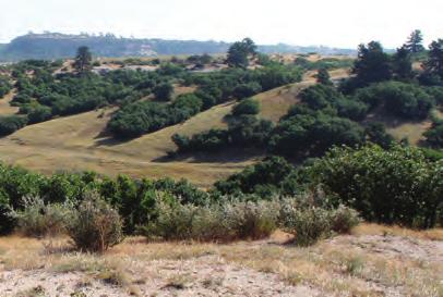
32 Report of Recommendations View of Wildcat Mountain from Preferred Site Topography, vegetation, views of Highlands Ranch from Preferred Site Topography and vegetation at Preferred Site Vegetation character and views at Preferred Site Figure 16. Preferred Site Existing Condition 28

33 Recommendations Implementation Introduction Implementation recommendations for the preferred plan included identifying potential costs for proposed improvements and infrastructure associated with the five amenities, analysis of potential revenue and operations costs, and providing a strategy for phasing improvements. As outlined by the Backcountry Wilderness Area s guiding documents any potential future project will be more fully developed through plan development, HRCA s accepted community involvement process (CIP), design and engineering and then construction. Figure 17. Next Steps to Implementation Diagram 29
34 Report of Recommendations Cost Summary General costing for improvements identified by this plan, including associated infrastructure, is expected to fall within the allocated available dollars of $4 million to be completed over a several year period. Costing was completed according to 2017 unit pricing and augmented by contingencies for escalation, contractor costs, and design and engineering. A more detailed costing analysis is included in the appendix. Covered Pavilion and Setting 5000 SF Building / Site $ 1M Utilities (dependent on utility providers) Potable water connection Entrance Drive and Parking $ 120K to $ 220K $ 500K $ 500K to $ 700K Equestrian Facility Site, Fencing and Shade Structure, Access Utilities (dependent on utility providers) $ 125K $ 10K to $ 30K Ropes / Adventure Course and Setting 50 Climbing Elements, Site, Access $ 350K to $ 550K Archery Olympic Course, Repurpose Existing Site $ 100K to $ 150K Trails Mountain Biking / Hiking / Overlook(s) $ 60K to $ 110K 30
35 Recommendations Financial Analysis of Operations and Potential Revenue BBC Research & Analysis conducted a financial analysis of operations for four proposed amenities for the Backcountry Wilderness Area. They modeled their analysis after similar operational facilities; examined financial data from HRCA and comparable sites; and estimated how expansion might affect visitation and how fees would increase revenues and expenditures compared to current operations. The more detailed analysis is presented in the appendix. BBC s analysis included the following: Archery Range Expansion Examined financial data from HRCA and other comparable archery sites to estimate how expansion might affect visitation and fees, and thus revenues and expenditures, compared to current operations Horse Facility Replacement Examined how an increase in horse camp attendance would increase revenues and expenditures, compared to current operations, based on financial data from HRCA Addition of Rope Course Modeled after rope courses at Epic Sky Trek Challenge at Phillip S. Miller Park, and the Genesee Rope Course at Genesee Mountain Park Addition of Covered Pavilion Modeled after the Chief Hosa Lodge at Genesee Mountain Park BBC s findings concluded that overall total revenues associated with the recommended amenities are expected to generate $559,000 annual revenues and $290,000 in annual expenditures. The archery and horse activities currently generate positive annual net operating cash flows. The proposed facility improvements are estimated to increase the combined operating net cash flows by about $17,500 per year, with about $137,000 in combined annual operating revenues and $80,000 in annual operating expenditures. The proposed rope course is estimated to generate $204,000 in revenues and $121,000 in expenditures, for an annual net cash flow of $83,000. The proposed pavilion facility will be used to host special event reservations such as weddings, birthdays, and family and corporate gatherings. It will also be able to host additional youth camps throughout the year. The estimated annual operating revenues are about $218,000, with annual expenditures of $89,000, for a net annual cash flow of $129,500. Overall, the total annual revenues associated with archery, horse activities, the rope course and the pavilion are expected to generate $559,000 in annual revenues and $290,000 in annual expenditures. 31
36 Report of Recommendations Figure 18. Phasing and Implementation Diagram 32
37 Recommendations Implementation Strategy The strategy for implementation of the amenities is based on the needs and desires expressed by the community and steering committee, and according to the expected revenue generation defined by the operations analysis. Implementation is expected to follow three general phases, whose timing is subject to change based on a variety of factors. Phase One The highest priority amenities for the community were the covered pavilion, expansion of the Base Camp program, hiking and mountain biking trails, and the associated infrastructure (roads, parking, and utilities). Creation of a detailed business and management plan is the initial action for phase one. This is followed by design and engineering of proposed improvements, and then construction of phase one amenities. Implementation of the covered pavilion and associated infrastructure and trails is expected to generate the most revenue. A traffic study, completed in conjunction with Douglas County, will be necessary to address issues or improvements associated with Grigs Road. Phase Two: Relocating the equestrian facility to the primary site with the covered pavilion and associated parking, and expanding the equestrian program is the second priority. Phase two includes completing the trail system including the equestrian trails, and infrastructure associated with the equestrian facility (service road, shelter, utility extensions), and relocates and expands the archery facility. The initial improvements for phase two focus on design and engineering for the equestrian facility at the recommended primary site. The traffic study, in conjunction with Douglas County, will be updated or continued to assess any additional improvements needed. The equestrian facility must move from its current location prior to the expansion of the archery facility. Once this facility moves, the archery facility will be improved. Trail construction continues in Phase Two. Phase Three: The final phase includes construction of the equestrian and archery facilities, and completion of the trail system and the ropes/adventure course at the primary site. Construction of all Phase Two projects will commence in Phase Three. Trail construction will continue if the desired trail network has not yet been established. The final amenity to be implemented is the Ropes Course, with design and engineering, and construction of this facility in phase three. Traffic and use studies will continue as needed. 33
38 Report of Recommendations (Intentionally left blank) 34
39 Appendix A APPENDIX A - SITE SELECTION AND ALTERNATIVES SUMMARY Existing Facilities Evaluation The Backcountry Wilderness Area staff and Highlands Ranch community have indicated that certain improvements to these facilities would greatly benefit both the Backcountry programs and the community. As visible above, the temporary shelters utilized by the Base Camp program aren t sufficient in inclement weather, and options are limited for gathering areas that provide shade and/or protection from weather. The archery facility is adequate for most Base Camp needs but doesn t offer much challenge to more advanced archers. The horse facility is adequate but stands to gain access to many more trails if relocated to the proposed site. All existing facilities are impacted by their proximity to the Highlands Ranch Law Enforcement Training Foundation site, where gunshots are frequently fired at an audible range from BWA programs. A-1


40 Report of Recommendations Existing Backcountry Base Camp, Chicken Coop Existing Backcountry Horse Facility with Shed and Temporary Shelter Existing Backcountry Base Camp Gathering Area Existing Backcountry Archery Facility Figure 19. Existing Facilities Photographs A-2
41 Appendix A Alternatives Summary Concept Development Each plan was subject to Steering Committee and Public comment via meetings and the HRCA website. Feedback was taken into consideration and incorporated where possible. Plans from each phase of site design and planning are included in this appendix. The Draft Preferred Concept Plan integrated Sites 3 and 4 as well as the preferred elements and arrangements from the initial concepts. Concepts Site 1 Concept Site 3 Concept A Site 3 Concept B Site 3 Concept C Draft Preferred Concept Plan A-3
42 Report of Recommendations Figure 20. Site 1 Concept N A-4
43 Appendix A Figure 21. Site 3 Concept A N A-5

44 Report of Recommendations Figure 22. Site 3 Concept B N A-6

45 Appendix A Figure 23. Site 3 Concept C N A-7

46 Report of Recommendations Figure 24. Draft Preferred Concept Plan N A-8
47 Appendix B APPENDIX B - COMMUNITY OUTREACH SUMMARIES Community Meeting 1 Summary August 30, 2016 Community Meeting 1 was held at Eastridge Recreation Center at 6:00 pm. Over 100 people attended, 64 signed in. Community Meeting 2 Summary October 6, 2016 Community Meeting 2 was held at Westridge Recreation Center at 6:00 pm. 36 attendees signed in. Community Meeting 3 Summary December 6, 2016 Community Meeting 3 was held at Southridge Recreation Center at 6:00 pm. 19 attendees signed in. Community Meeting 4 Summary February 28, 2017 Community Meeting 4 was held at Eastridge Recreation Center at 6:00 pm. 13 attendees signed in. B-1
48 Report of Recommendations Backcountry Wilderness Area Highlands Ranch Community Association Community Open House Meeting 1 Meeting Summary for August 30, 2016 At 6:00 pm on August 30, 2016, Highlands Ranch Community Association held an open house at Eastridge Recreation Center to present potential sites for proposed program elements and gather public input on the proposed program and locations. Approximately 64 attendees signed the sign-in sheets (attached). Mundus Bishop helped facilitate the event. The agenda included: A brief PowerPoint presentation explaining the project s background and purpose, potential program elements, and potential sites for proposed improvements (See PDF of PowerPoint for presentation images and content.) An Open House segment to gather the community s ideas, preferences, and comments on the presented options During the Open House portion of the evening, attendees were invited to share their ideas and comments by reacting to images, words, and questions. Attendees wrote their responses on large sheets of paper and placed sticker dots near images to express support of a precedent. (See photographs below.) The community expressed a diverse range of opinions regarding the proposed program and locations. Some attendees supported the proposed program, some expressed interest in elements not included in the current program, and others suggested that none of the proposed elements be implemented. Below is a summary of the responses from the community. Following the summary are images that document the community s input and the sign-in sheets. Comment Summary Do you prefer close proximity/access from Highlands Ranch or a longer distance between residences and improvements? Longer Distance: 12 Closer proximity: 3 Neutral: 2 Other Comments: Water Rights?? Will this block elk migration? (No, these herds don t migrate seasonally) Use base camp for ropes course, complimentary activities I like the mid-range 1/1a or 3 B-2
49 Appendix B Areas 1, 1a, &2 seem to have good proximity, but are good distance away, too. Add Traffic Circle at Griggs & Craftsbury to slow traffic, maybe at Posten, too! Issues from the Sanctuary for sites 4 & 5? No additions- these are not improving the backcountry. Do you like the idea of a barn or ranch house aesthetic for the covered pavilion? Barn: 14 No/None: 2 Other Comments: Why can t HR Mansion be a pavilion? <Great use of existing resources, cost = FREE The existing pavilions are not fully utilized so why build more? Open air structure for gathering What about traffic on Griggs? What about the bison? TeePee Is the best use of HOA dues? How much will this cost us!!?? Who pays for this? (OSCA fund has $ for these improvements) Do you like the idea of a 3D archery in addition to a traditional archery range? Yes: 15 Reasons: Because I feel like it will be awhile for something like this to come out anywhere else. It will also give the ability for a real hunting experience and give people the ability on practicing on a real life target! 3D is vastly different than existing archery range. It will nurture skills that are useful in the wildlife management that HR must do. Strongly support a 3D range. Nothing like it in the area! Nothing close in the area that doesn t require a membership or a 2 year waitlist! Olympic distances! Less wind the better. Come out and watch these kids sometime. It s really cool. Low wind areas! Maybe/Need More Info: 3 No: 9 Reasons: Does an archery range need to be located in a wilderness area? Are there other potential sites outside of the BCWA that should be analyzed? B-3
50 Report of Recommendations Amen! More Wilderness! Seems to cater to limited population/audience (Many amenities in HRCA are for limited interests. With 95K population, a small % is still a lot of people, eg: ballet, tennis, swimming) Do you like the idea of locating improvements around a historic landscape feature such as a former homestead site? Yes: 12 Reasons: Being located on the historic site would be interesting for visitors. Homesteaders chose that site years ago to be sheltered from wind. Perfect for our use. But leave Griggs homestead structures and stone because I will love to see some history when I m in Backcountry. It makes sense to make space that is already somewhat developed more useful. A restoration of home site building would keep the Highlands Ranch feel. Would give opportunity for another type of program type (ie: move chickens here) Keep any new developments located within existing developments, no need to scatter the impact to the wilderness. Wilderness is only virgin once, build on existing sites only! I didn t know a homestead site existed. No: Why are these considered improvements. (2) Should the proposed improvements be visible from Griggs Road? From Highlands Ranch residences? Visible from Griggs OK: 5 Reasons: There is an entire city visible from Griggs Rd (3) Visible from Griggs NOT OK: 3 No/minimal visibility from residences: 9 Reasons: The distances are quite large, minimal visibility is ok. Most ideas have limited size structures. Minimal visibility from the road, signs are good for advertising Minimal visibility of pavilion would be acceptable, NO visibility of ropes course. Other comments: No- they aren t improvements. You are tearing up the backcountry and putting structures, roads, not improvements! (Ditto x2) Leave it alone! As long as it s well done it doesn t matter. B-4
51 Appendix B Will this add more light pollution? Implement traffic calming on Griggs Day events only, no light at night. It doesn t matter because any open space you will see a lot of human involvement. Do you like a centralized cluster of improvements, or more dispersed? Cluster: 2 Reasons: To keep away from any animal activity Dispersed: 6 Reasons Maybe share parking (yes) Space them out over 2-3 sites To keep natural feel Would be possible in Areas 1, 1a, and/or 2 The archery range and horses should be farther away from other structures for safety (yes, but horse away from shooting 1 area) You don t want congestion or facilities to be on top of each other. Other Comments: No- no cluster at all- leave it alone! (Ditto x 2) No- I don t see a need or benefit to clustering. Central place to gather, then disperse from there How is this an improvement? (Ditto) Leave it alone! Elk and animals #1 Like to see the development of existing locations farther west and leave the sites near Griggs in more natural state. Other Ideas- What s not on the list? Leave it alone! (2) Why is this being proposed? A cogent reason must be clearly stated. More running/hiking/bike trails If we build an equestrian facility, will this use the existing trails or will a new/separate network be built? How will the increased horse traffic affect other uses of the trail? (positive or negative) (yes??, please answer) 2+ acre dog park (off leash) (yes, no, no) Disc Golf Course (18 holes) (Mtn Vista has some) Respect Community Survey Bike Park like Ruby Hill or Valmont (Yes!, Right on!, These places are awesome!) B-5
52 Report of Recommendations A bike park that provides facilities to all riders: strider track, pump track, short track, jump park, skills course, cyclo x track (for the children) (It would be close to home, wouldn t have to drive to Parker or Boulder or Winter Park- great for kids who can t drive) (Great idea for all ages of the HR community. The cycling community is growing and a bike park are would be well used) (Yes! Excellent Idea/Plan, No, Kids Mountain Bike Skills area) (Yes!!! Jason Blackford, Fun for the whole family!) (Revenue for HR like backcountry races) (No!!! ) One way and single user (horse, hiker, bike only) trails. (yes, ditto) More hiking paths like backcountry west of Griggs Rd (yes, yes) Only if our kids get out to appreciate the outdoors, will they commit to preserve it. I d like to make sure that any potential development of that portion of the backcountry involves an expansion of hiking/walking trails.(yes) Since HR is growing older- more older generation, I would like to see more amenities for them. Roping, horses, and archery really wouldn t be. The gazebo would, but there should be more that they can utilize. Along with their families, of course. (I agree, a central area for outdoor programs for all kids through seniors) Xeric landscape demo garden Character Agricultural Structure Indoor/Outdoor Ames Family Ranch Style (yes) off the grid solar (yes x3) Griggs Road dirt compared to asphalt (keep it dirt x2) No Thanks The minimalist approach in the bottom left could be an interim/test using temporary structures like tents/port-a-potties for events. If successful, more permanent structures. How are you going to pay for a permanent structure? There will be a lot of ongoing maintenance costs to this? No permanent structures! Don t pave Griggs! (yes x5) (Says the people who chose to live near Griggs. HR is 90K other people too!) Day activities only (yes x2) Protect the wildlife! (amen!) Build a structure at HR Mansion? (We already have the HR mansion, we do not need another wedding venue!!) B-6
53 Appendix B Rustic We need natural-botanical area for viewing After these amenities are completed, will there be further development of the backcountry? Word Map Adventure (5) Base Camp (1) Rustic (6) Close (1) Barn (3) Natural (6 Risk (1) (Averse) Nestled (1) (Mostly) Hidden (1) Accessible (1) Explore (2) Valmont/Ruby Hill Style Bike Park (6) Do Nothing (6) Precedent Images There was a strong adverse reaction to the Ropes/Adventure Course precedent imagery. A lot of support for Archery, and some support for an Equestrian Trail. There was support for all Covered Pavilion/Venue images, all represent some form of rustic, barn aesthetic participants liked. B-7


54 Report of Recommendations Figure 25. Community Input Question Board 1 Figure 26. Community Input Question Board 3 Figure 27. Community Input Question Board 2 Figure 28. Community Input Question Board 4 B-8


55 Appendix B Figure 29. Community Input Character Board Figure 30. Community Input Precedent Board: Covered Pavilion Figure 31. Community Input Word Board Figure 32. Community Input Precedent Board: Equestrian/Ropes B-9
56 Report of Recommendations Backcountry Wilderness Area Highlands Ranch Community Association Community Open House Meeting 2 Meeting Summary for October 6, 2016 At 6:00 pm on October 6, 2016, Highlands Ranch Community Association held an open house at Westridge Recreation Center to present conceptual alternatives and gather public input on the proposed concept plans. Approximately 36 attendees signed the sign-in sheets (attached). Mundus Bishop helped facilitate the event. The format included: Two separate rooms set up with boards on tables and easels. The boards were arranged to allow participants to learn about Backcountry history, how the proposed program was developed, the overall site context and scale of proposed amenities, and four concept plans. Mundus Bishop and BWA staff and steering committee members were present to guide participants through the series of boards, answer questions, and encourage them to record their comments on comment cards or large sheets of paper. The community expressed a diverse range of opinions regarding the concept plans. Some attendees expressed support for the concept plans; some expressed interest in elements not included in the current program, and others suggested that none of the proposed plans be implemented. Below is a summary of the responses from the community. Following the summary are comment cards, images that document the community s input and illustrate the variety of viewpoints represented at the meeting, and the sign-in sheets. Comment Summary Site 1: Large Common Area (no x 1) Heavy Use- Impacts? Lighting Impacts? Mountain Bike Loop (no x1) Comments: Good- keep all out of Area E for Elk Bad- heavy congestion- scare away wildlife Night sky! No lights Heavy traffic on Griggs and Poston Additional access road behind Hearth? (bad x1) This plan and Future Douglas County Park may cut total land area in half! (bad x 2) B-10
57 Appendix B Minimize extend of utilities Like Horse facility at old corral Please don t pave our paradise I will pay higher dues, quality of (wild)life is most important Site 3/Option A Mountain Bike Area? No bike park or races (x7) Why not multi-use trail- ped and bikes Like mountain bike loop; allows for future expansion and connection Eastward to Monarch without crossing roads Consider bike park (like Valmont in Boulder) instead of ropes course. More revenue opportunities via host cyclocross races and offers more diversity than a ropes course - MAC in Castle Rock only 10 minutes away. Horse Trail in Area E? No, keep for wildlife. Like Conservation easement on E and east of Monarch Additional Comments: Alt Option- Do not build anything! Open space will only be open space/wilderness once. Increased traffic on Poston from cut through traffic. Elementary school right on Poston. Increase traffic is a danger to those kids. (I agree!) Ropes courses not needed. Recreation needs to be wild, ie: no artificial structures We moved here for the wild spaces Please just raise our dues (worth every penny!) Site 3/Option B No Horse Trails in Area E Additional Comments: I like the ped trails here- connect to Monarch ped trail? Least impactful option Like this option, has safe access at intersection, less impact to overall area and can be expanded in the future. Could add mountain bike trail from option at with minimal cost. Option- do nothing! Do not build! Site 3 Option B Best- less effect on elk B-11
58 Report of Recommendations Keep most of the pace open as native land and do the least amount of development as possible- keep it the back country (yes!) Ped trails ONLY ok, but we really don t need more. (we do need more) Site 3/Option C Planning Area E Horse trails in Elk Area Keep E for wildlife, not horses Lighting Impacts for wildlife? Comment Cards (11) comment cards were collected at the meeting. They are attached below. Additional Comments (from s) Is it too late to put in my vote for a year-round Archery range? :) We are supportive of keeping all of the space as development-free as possible. The Elk need the space and use it all. Is there a sense of how these potential development options would influence the home values that border the open space in the Backcountry (like ours). Thanks! I just wanted to write a quick note to propose an idea at tonight s HOA meeting. I am in scouting and there is no place with in 40 miles where I can take the scouts target shooting with air rifles. To have a location close like the archery range would be a wonderful amenity to teach youth gun safety. Air rifles are fun to learn and shoot with youth. Air rifles are less dangerous than even a bow. Our scout troop would love to be part of a program such as this and could volunteer to build / clean / plan a target range such as this. Dear BoD: I attended the Open House on August 30, I was disappointed by the opening presentation as the speaker tried to tell us what the community needs are, and what amenities were being undertaken. I don t agree that the needs she stated are supported by the community. I listened to the various development options, but didn t hear anything about no development, or we already have enough development. I was also alarmed to learn this study cost over $44,000. And is budgeted for $100,000 in Are you listening, or is it a foregone conclusion this is going to proceed? I was asked to give you feedback. I strongly believe we should leave it as it is. I am a mountain biker who lives in Highland Ranch, and I ride the Backcountry area at least once a week. I love the HRCA trails in the Backcountry because they are relatively close and I can ride from my house. The thing that makes these trails fun is they are narrow single tracks creating a challenge as they wind through the beautiful country. HRCA truly did a great job in building those trails, I especially like the Bad Lands trails, and I am not alone in my opinions. Being out in the Backcountry frequently I can tell you mountain biking is probably the best fit for much of the area. It is a relatively inexpensive sport, all you need is a bike, so most people can afford to do it and it allows the rider to get miles and miles into the Backcountry. The only other users that can B-12
59 Appendix B get that far back into the Backcountry are a handful of people who own horses and some hard core trail runners. Currently the overwhelming majority of Backcountry users are mountain bikers, I estimate 90% to 95%.I know you are currently working on a plan for the Backcountry area, so I am writing as a mountain biking advocate. I think the best way to get more people into the Backcountry is to create more accessible mountain bike trails. There are lots of youth in the Highlands Ranch area that do not own a car, but if they could ride a mountain bike from their home to a fun trail, perhaps they would. A fun mountain biking trail is a narrow trail/single track not a dirt road. Sadly Douglas County recently widened and graded the EAST/WEST Trail into a wide trail/road which ruins it for mountain biking. I think most mountain bikers would prefer ride only on even or odd days or simply have a separate trails as apposed to flattening and widening all trails to the lowest common denominator of user. Thanks for listening, and I hope HRCA will continue to support its mountain biking community. Due to work travel, I was unable to attend your first open house on backcountry development and wanted to voice my concern that there is not a status quo option. The backcountry area is a rich resource for all of Highlands Ranch if properly managed. I know that you have engaged outside resources to provide research on the various options available for recreation. As board members, you are entrusted with ensuring the best decision making for the entire community and I hope that you take into consideration the issues of traffic, existing homeowners and the ecosystem itself in your future planning. While the open house was informative, I was disappointed to see that the Conceptual Plan and presentation did not adequately address the option of doing nothing. It appears that it is a forgone conclusion that development will happen. However, after reviewing 2012 Community Survey, it appears that HRCA is going against the majority of respondents. I support the idea of creating an archery range.we have in HLR good facilities for sports; I love that. Most of the facilities are for sports where age, weight, high, gender segregates who you can play or compete with. Archery, at the way I see it, has less segregation by those factors. It makes easier for parents and their kids to practice a common sport and play/compete together: Gender, weight, high are not important factors to play/compete. Age does, but starting from mid teenager and older age, it does not give advantage On last competition, I wish I was able to shoot like that 16 years old kid; he made better scores that the senior archers competing. As a resident of this community, an avid user of the Backcountry wilderness area, and the parent of an archer I want it to be known the importance of working to keep and improve Archery as a part of the Backcountry Wilderness area. I seems as soon as people mention development and backcountry in the same sentence most people have a visceral reaction and immediately want to shut it down. To be so small minded and disregard the population that finds great value in the backcountry is truly a shame. If the mission of the Backcountry is Provide visitors with unprecedented opportunities to enjoy nature near where they live, while protecting and conserving natural, cultural, archaeological, and historical resources for the enjoyment of future generations. How can the opportunity to increase the value, enjoyment and unique environment of the Backcountry be discussed without considering expansion of archery for our community. Highlands Ranch has always been unique, a gem of a community, offering opportunities and experiences not found in other planned neighborhoods, in other areas. Including the development of archery in Backcountry planning will continue the mission to allow residents to connect with and enjoy B-13
60 Report of Recommendations nature. It does not have to mean mass destruction of any one area. Expansion of the Archery can be achieved on a scale which has a hugely positive impact to it s users, while not destroying the landscape. No one supporting the Archery program is asking for huge buildings or Costco sized paved lots. We want the opportunity to grow in the sport, to appeal to newcomers, to accommodate love of the sport. Expansion could allow for school teams and clubs to form and participate, where now this is little for them. If you are an Archer, or wish to be, you cannot do so with your school. Admittedly the logistics to making this possible at even some schools would be insurmountable. HRCA has a way to fill this gap, to show leadership and support of it s community. My son gets so much from participating with Coach Dorow s team, but everybody wants the chance to wear their school colors too. The community can make this happen. The July tournament offered a unique opportunity for our son to experience competition unlike any other. It was a brutally hot day, but he loved it. Another opportunity you just can t get anywhere else - and it could be even better with support of HRCA. And in case you don t already know, Coach Chris Dorow brings more to a lesson of Archery than just Tips on Toes. He is committed to also supporting the growth of his young students into responsible, respectful, and confident young adults. He works to encourage their love of the sport and the growth of their confidence. His passion for sport and the positive impact it can have are evident in his work with his students. Students who wish to learn something outside of the norm cannot grow and expand their experience without development of the Archery program. No program with such potential in HRCA should be limited in such a way. We have the best, we should make the most of it. I cannot be at the meeting tonight however I ask the voice in support of some Backcountry development not be drowned out, that our voice be represented and brought to light. Any improvements that could be done to the archery range (or a new range) would be great. While the range is open, I can normally be found there 3-4 times a week for an hour or so. I have been using the archery range since it opened 4-5 years ago. Over the years, its use and the diversity of users has grown tremendously. Especially with Chris JOAD group. The addition or a 3D range and the ability to shoot at ranges beyond 60 yards would be great. From a cost perspective, I would be willing to pay an additional fee to utilize a 3D range. Another improvement that would be nice (although for a smaller group of people) would be a Sport dog training area. No this is not a dog off leash area, but a true sport dog training area where people who participate in Hunt/Field trials can train their dogs. This is not an area to let the dogs run free, but rather a place where dogs are ran through retrieves and handling drills under the direction of their handler/owner. All that is required is a parking area and access to a larger section of grassland. Environmental impact is almost non-existent compared to Dog parks, and these types of dogs are under hand and whistle control at ranges beyond yards. Chatfield state park currently has an area similar to this, but having a facility closer to home and possibly less crowded would be a great asset. With the additional mountain bike trails the past few years, we have a world class trail system in our back yard. I do not think any more trails need to be added, and the backcountry can start focusing on other potential uses as mentioned above. As for a lot of the rest of the areas, I believe Mark and his crew have done a great job to balance the leave it alone and how can I enjoy the area views. My wife and I have participated in many of the backcountry activities: Art, Smores, and more, backcountry date night, Backcountry Fence Removal, Mountain Bike trails and the horseback riding. And maybe one day I will get drawn for a hunt in the backcountry! Our friends have younger kids who participate and love all the youth activities and camps that are provided - moving this to the Police B-14
61 Appendix B Training area was viewed as an awesome improvement! We would like to continue seeing the area used in this non-impact manner where the residents of highlands ranch and the wildlife can co-exist. I am opposed to any backcountry wilderness development. Please let the residents of Highlands Ranch enjoy the trails and beauty of an already overdeveloped community. I would love to see the open space preserved in its present state forever. B-15


62 Report of Recommendations Figure 33. Community Input Board Site 1 Concept Figure 34. Community Input Board Site 3 Concept A Figure 35. Community Input Board Site 3 Concept B Figure 36. Community Input Board Site 3 Concept C B-16

63 Appendix B Figure 37. Comment Cards Figure 38. Comment Cards B-17


64 Report of Recommendations Figure 39. Comment Cards Figure 40. Comment Cards B-18


65 Appendix B Figure 41. Comment Cards Figure 42. Comment Cards B-19
66 Report of Recommendations Backcountry Wilderness Area Highlands Ranch Community Association Community Open House Meeting 3 Meeting Summary for December 6, 2016 At 6:00 pm on December 6, 2016, Highlands Ranch Community Association held an open house at Southridge Recreation Center to present the preferred conceptual plan and gather feedback from the community. Approximately 19 attendees signed the sign-in sheets (attached). Mundus Bishop helped facilitate the event. The agenda included: A PowerPoint presentation explaining the project s background and purpose, potential program elements, the preferred concept plan, and how the plan was developed per survey data and community feedback (See PDF of PowerPoint for presentation images and content.) An Open House segment to gather the community s ideas, preferences, and comments on the conceptual plan. During the Open House portion of the evening, attendees were invited to share their ideas and comments by reacting to images and questions. Attendees wrote their responses on large sheets of paper and completed comment cards. The community expressed a diverse range of opinions regarding the proposed program and location. Some attendees supported the proposed program, some expressed interest in elements not included in the current program, and others suggested that none of the proposed elements be implemented. The following is a summary of the responses from the community. Do you like the Base Camp/Pavilion in a screened location with views? Other Comments: Shouldn t the real question be if we want a pavilion? Only day use-no nighttime events (no weddings)(yes.) Not as a banquet facility (Yes.) Do you like the idea of seeing horses from Grigs Road? Yes: 2 Other Comments: Fine, we see them now. If it would mean better security for them to not be visible, then no. Whatever is best for the horses. Do you like that the new archery site (off Santa Fe) re-uses the existing Horse Facility? B-20
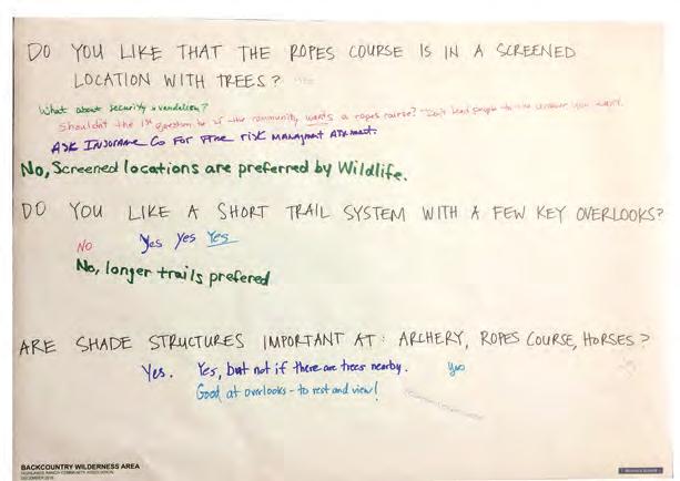
67 Appendix B Yes: 4 No: 1 Reasons: Not as convenient. Other Comments: Do not mind the existing site off Monarch. Do you like that the ropes course is in a screened location with trees? Yes: 1 No: 1 Reasons: Screened locations are preferred by wildlife. Other Comments: What about security and vandalism? Shouldn t the first question be if the community wants a ropes course? Don t lead people to the answer you want. Ask insurance company for free risk management assessment. Do you like a short trail system with a few key overlooks? Yes: 3 No: 2 Comments: Longer trails preferred Are shade structures important at: archery, ropes course, horses? Yes: 4 Comments: But not if there are trees nearby. Good at overlooks- to rest and view! Protect ridgelines Do you like shared parking for the Pavilion/Base Camp, Ropes Course, and Horse Facility? Yes: 2 Comments: Is Douglas Co. prepared for increase maintenance on Griggs/Daniels Park Roads? Other Comments: Was the original question asked? If the community wants this? B-21
68 Report of Recommendations If pavilion is open to the public for events then most weekends will be crowded with weddings etc. Parking will be a problem, access to trails etc will be impacted due to the large group for an event. Which facility/activity is most important to you? Trails only Trails I support a base camp facility with classrooms but not an event center If you build a pavilion make it big enough for events (No events) (No events, keep it small) (Agree, but need to minimize traffic and parking. Shuttle from remote/school parking?) Security v. Dark Sky? Dark Sky more important so limit what is there. Do you like the idea of a flexible outdoor space around the Pavilion/Base Camp? Yes. Just minimize traffic. No pavilion, base camp, or flex space. Anything Else? Detailed plan for wildlife protection prior to any development. (Yes/Agreed x4) Contract to ensure no further development after this area is developed (Yes x3) What is the night security plan to keep teens our of area/ropes? Risk? (Vandalism will be a problem) (<- Agree!) Please do NOT do this project! The effect on Nature wildlife is too severe/strong/detrimental. (Yes) How did the #s for the ropes course be determined? What were they based on? Has use/profit from Parker been looked at? (Cost in Castle Rock/Parker is same $100) Integrate a disk golf course into the trails/amenities. Low Cost/Blend in/low traffic. (No) Protect night sky- day use only (Yes!) (No lights) If revenue is needed to fund the backcountry- why not use the $4m to fund the backcounry. (Spin money from here for additional $200K)(Invest the $4m and use income to fund the $200K)(Agree! Why are we doing this? $$) If NI on this project is only $200k, why do this? (Exactly) If $$ is the purpose, raise HOA dues $5.00 What are current anticipated cost of pavilion use and rope course use? What about Traffic on Poston? Copper Mesa Elementary is on Poston and there will be lots of cut thru traffic! (Increased traffic on Poston is a concern) There is an existing elk herd off Grigs/Monarch. What happens to them? (Yes) How is the rope course going to be protected? If High, then visible. If Low, people will access/vandalize. There are several close by ropes course, by adding another one, revenues for all will decrease. Was this considered in our revenue projects. Market saturation B-22


69 Appendix B Figure 43. Community Input Board Site 1 Concept Figure 44. Community Input Board Site 3 Concept A Figure 45. Community Input Board Site 3 Concept B Figure 46. Community Input Board Site 3 Concept C B-23


70 Report of Recommendations Figure 47. Comment Cards Figure 48. Comment Cards B-24

71 Appendix B Figure 49. Comment Cards B-25
72 Report of Recommendations Backcountry Wilderness Area Highlands Ranch Community Association Community Open House Meeting 4 Meeting Summary for February 28 th, 2017 At 6:00 pm on February 28, 2017, Highlands Ranch Community Association held an open house at Eastridge Recreation Center to present the preferred conceptual plan and gather feedback from the community. Approximately 13 attendees signed the sign-in sheets. Mundus Bishop helped facilitate the event. The agenda included: A PowerPoint presentation explaining the Backcountry s background and purpose given by Mark Giebel. A verbal presentation (with boards) covering: proposed program elements, the preferred concept plan, and how the plan was developed per survey data and community feedback (See PDF of PowerPoint for presentation images and content.) An Open House segment to gather the community s ideas, preferences, and comments on the preferred plan and draft phasing. During the Open House portion of the evening, attendees were invited to share their ideas and comments by reacting to images and questions. Attendees wrote their responses on large sheets of paper. The community expressed a range of opinions regarding the preferred plan and preliminary costing and phasing. Most attendees supported the proposed program and were excited about its potential implementation. The following is a summary of the responses from the community. Which of the proposed Backcountry amenities would you like to see implemented first? Recommend pavilion first. There are a lot of trails that I use daily (am/pm) and see relatively few people, so trails second. Definitely the pavilion to generate the revenue to return to the Backcountry. Which of the proposed Backcountry amenities would you use the most? Existing trails. Would HR have events at pavilion and not just for day camps? Ropes/trails Which of the proposed Backcountry amenities is your favorite? Why? Pavilion- more meeting/event space is needed in HR and I love the outdoor feel. Trails- the addition of 3.5 miles of trials is fantastic. Anything we can do to get the residents and youth of experience the Backcountry is good. Pavilion and expanded trail system B-26
 good?")

73 Appendix B Which Backcountry activities would you (and your family) participate in? Anything else? Could the orange trail network be dog-friendly? (not many of our trails are) good? I see dogs on trails they aren t allowed on weekly. Could the pavilion have a large stone fireplace for people to gather around as the evenings cool off? (safely) Could we have more overnight camping events in the Backcountry? Figure 50. Community Input Board 1 Figure 51. Community Input Board 2 B-27
74
75 Appendix C APPENDIX C - FINANCIAL ANALYSIS OF PROPOSED IMPROVEMENTS Summary BBC conducted a financial analysis of operations for four proposed improvements in the Backcountry Archery Range Expansion Examined financial data from HRCA and other comparable archery sites to estimate how expansion might affect visitation and fees, and thus revenues and expenditures, compared to current operations Horse Facility Replacement Examined how an increase in horse camp attendance would increase revenues and expenditures, compared to current operations, based on financial data from HRCA Addition of Rope Course Modeled after rope courses at Epic Sky Trek Challenge at Phillip S. Miller Park, and the Genesee Rope Course at Genesee Mountain Park Addition of Pavilion Modeled after the Chief Hosa Lodge at Genesee Mountain Park The archery and horse activities currently generate positive annual net operating cash flows. The proposed facility improvements are estimated to increase the combined operating net cash flows by about $17,500 per year, with about $137,000 in combined annual operating revenues and $80,000 in annual operating expenditures. The proposed rope course is estimated to generate $204,000 in revenues and $121,000 in expenditures, for an annual net cash flow of $83,000 The proposed pavilion facility will be used to host special event reservations such as weddings, birthdays, and family and corporate gatherings. It will also be able to host additional youth camps throughout the year. The estimated annual operating revenues are about $218,000, with annual expenditures of $89,000, for a net annual cash flow of $129,500. Overall, the total annual revenues associated with archery, horse activities, the rope course and the pavilion are expected to generate $559,000 in annual revenues and $290,000 in annual expenditures. C-1


76 Report of Recommendations C-2

77 Appendix C C-3


78 Report of Recommendations C-4

79 Appendix C C-5

80 Report of Recommendations C-6

81 Appendix C C-7
82 Report of Recommendations C-8


83 Appendix C C-9

84 Report of Recommendations C-10

85 Appendix D APPENDIX D- COST ESTIMATE D-1

86 Report of Recommendations D-2
PROPOSED PARK ALTERNATIVES
 8 Chimne y Rock State Park M a ster Pl an 2011 PROPOSED PARK ALTERNATIVES Introduction Three different park development concepts were prepared and presented to the citizens of North Carolina through a
Longmont to Boulder Regional Trail Jay Road Connection DRAFT FINAL REPORT
 Longmont to Boulder Regional Trail Jay Road Connection DRAFT FINAL REPORT December 2018 Project Summary Boulder County, Colorado, in partnership with the City of Boulder, is evaluating options for multi-use
EXECUTIVE SUMMARY PROGRAM DEVELOPMENT REPORT PURPOSE EXISTING SETTING EXPANDING PARKLAND
 EXECUTIVE SUMMARY PROGRAM DEVELOPMENT REPORT PURPOSE As the culmination of the first phase of the master planning process, this Program Development Report creates the framework to develop the Calero County
Preferred Recreation Recommendations Stemilt-Squilchuck Recreation Plan March 2018
 Preferred Recreation Recommendations Stemilt-Squilchuck Recreation Plan March 2018 Below are the recommended recreation ideas and strategies that package together the various recreation concepts compiled
RE: Access Fund Comments on Yosemite National Park Wilderness Stewardship Plan, Preliminary Ideas and Concepts
 September 30, 2016 Superintendent Yosemite National Park Attn: Wilderness Stewardship Plan P.O. Box 577 Yosemite, CA 95389 RE: Access Fund Comments on Yosemite National Park Wilderness Stewardship Plan,
PALO CORONA REGIONAL PARK MPRPD BOARD MEETING AUGUST 8, 2018
 PALO CORONA REGIONAL PARK MPRPD BOARD MEETING AUGUST 8, 2018 ACKNOWLEDGEMENTS AGENCIES AND ORGANIZATIONS The Trust for Public Land Big Sur Land Trust Santa Lucia Conservancy California State Parks Point
Attendance Presentation
 TO The Community of Saanich FROM District of Saanich DATE January 30, 2017 RE Meeting Notes Haro Woods Jan 28th Community Engagement Goward House, 2495 Arbutus Road, Victoria BC Attendance In total, 18
Lake Myra County Park. Wake County, North Carolina Community Forum #2 June 12, 2008
 Lake Myra County Park Wake County, North Carolina Community Forum #2 June 12, 2008 Welcome and Introduction Meeting Agenda Welcome Introductions of Project Team Master Plan Process Community Forum #1 Updates
EAST DON TRAIL ENVIRONMENTAL ASSESSMENT. Community Liaison Committee Meeting #3 July 15, :30 to 8:30 pm Flemingdon Park Library
 EAST DON TRAIL ENVIRONMENTAL ASSESSMENT Community Liaison Committee Meeting #3 July 15, 2013 6:30 to 8:30 pm Flemingdon Park Library Agenda 1. Welcome 2. Housekeeping and Updates a) Housekeeping b) CLC
JOSLIN FIELD, MAGIC VALLEY REGIONAL AIRPORT DECEMBER 2012
 1. Introduction The Federal Aviation Administration (FAA) recommends that airport master plans be updated every 5 years or as necessary to keep them current. The Master Plan for Joslin Field, Magic Valley
RIVER ACCESS STRATEGY
 RIVER ACCESS STRATEGY The River Access Strategy is a 10-year plan the City of Edmonton is developing to inform future programming, operations and infrastructure improvements that support access to the
Welcome to the future of Terwillegar Park a Unique Natural Park
 Welcome to the future of Terwillegar Park a Unique Natural Park 1 Introduction The Terwillegar Park Concept Plan study will develop an overall concept plan, management objectives and development guidelines
Logo Department Name Agency Organization Organization Address Information 5700 North Sabino Canyon Road
 Logo Department Name Agency Organization Organization Address Information United States Forest Coronado National Forest 5700 North Sabino Canyon Road Department of Service Santa Catalina Ranger District
Dungeness Recreation Area County Park Master Plan
 Dungeness Recreation Area County Park Public Outreach Meeting October 10, 2007 Project Overview USFWS Site Dungeness Recreation Area County Park Meeting Objectives: Re-Introduce project; provide status
The Vision for the San Juan Islands Scenic Byway
 The Vision for the San Juan Islands Scenic Byway 2 Judd Cove, Orcas Island, Courtesy of Kurt Thorson (kurtthorson.com) and San Juan County Land Bank Vision for the San Juan Islands Scenic Byway The San
12, 14 and 16 York Street - Amendments to Section 16 Agreement and Road Closure Authorization
 REPORT FOR ACTION 12, 14 and 16 York Street - Amendments to Section 16 Agreement and Road Closure Authorization Date: April 27, 2018 To: Toronto and East York Community Council From: Senior Strategic Director,
Section II. Planning & Public Process Planning for the Baker/Carver Regional Trail began in 2010 as a City of Minnetrista initiative.
 Section II Planning & Public Process Planning for the began in 2010 as a City of initiative. city staff began discussions with the Park District on the possibility of a north/south regional trail connection
Silver Lake Park An Environmental Jewel for the Citizens of Prince William County
 Silver Lake Park An Environmental Jewel for the Citizens of Prince William County The Prince William Park Authority Mission Statement states: The Prince William County Park Authority will create quality
NOTE: YOU MAY COMPLETE THIS SURVEY ONLINE (USING THIS DOCUMENT TO VIEW MAPS AND GRAPHICS) AT:
 AT:") for completing the Town of Beech Mountain Comprehensive Planning Survey. The information you provide in reply to the following questions will be used to help the Town develop a plan that will guide our
for completing the Town of Beech Mountain Comprehensive Planning Survey. The information you provide in reply to the following questions will be used to help the Town develop a plan that will guide our
Decision Memo Broken Wheel Ranch Equestrian Outfitter Special-Use Permit Proposed Action
 Decision Memo Broken Wheel Ranch Equestrian Outfitter Special-Use Permit USDA Forest Service Mississippi Bluffs Ranger District, Shawnee National Forest Jackson and Union Counties, Illinois Proposed Action
Thank you for this second opportunity to comment on the proposed revisions to the Coconino National Forest Management plan.
 March 8, 2011 Flagstaff Biking Organization PO Box 23851 Flagstaff, AZ 86002 Yewah Lau Coconino National Forest Attn: Plan Revision 1824 South Thompson Street Flagstaff, Arizona 86001 Sent via electronic
Committee. Presentation Outline
 CW-33-15 11/9/2015 Community and Corporate Services Committee November 10, 2015 1 Presentation Outline Background Vision and Objectives Study Process and Timeline Public and Stakeholder Engagement Organization
Belfountain Complex - Stakeholder Advisory Committee Meeting Belfountain Conservation Area Property Tour Date: Time: Meeting Purpose
 Belfountain Complex - Stakeholder Advisory Committee Meeting Belfountain Conservation Area Property Tour Date: Thursday, October 9, 2014 Time: 6:00pm 7:30pm Meeting Purpose: A tour of Belfountain Conservation
2. Goals and Policies. The following are the adopted Parks and Trails Goals for Stillwater Township:
 D. PARKS AND TRAILS 1. Introduction Stillwater Township s population is relatively low, with most residents living on rural residences on large lots. The need for active park space has been minimal in
Land Management Summary
 photo credit: ANGAIR Anglesea Heath Land Management Summary The Anglesea Heath (6,501 ha) was incorporated into the Great Otway National Park in January 2018. This provides an opportunity to consider the
Steps in the Management Planning Process
 Steps in the Management Planning Process Developing a management plan for Kalamalka Lake Park will follow a multi-stage process. The planning process for this park is currently in the Draft Management
Brinker Creek Ranch. Colorado - Routt County - Yampa
 Located at the base of the Flattops Range in the Steamboat/Vail corridor, Brinker Creek Ranch consists of 1,451 acres ideally suited for high country grazing and native grass hay production. Traditionally
HLUET TRANSMITTAL RECOMMENDED ACTION
 HLUET TRANSMITTAL TO: Housing, Land Use, Environment & Transportation Committee Prepared by: Elish Ryan, Park Planner FROM: Lisa Killough, Director DATE: November 1, 2002 Reviewed by: Mark Frederick, Planning
MASTER PLAN EXECUTIVE SUMMARY
 Biscuit Run State Park Scottsville Road (State Route 20) Charlottesville, VA 22902 Biscuit Run State Park MASTER PLAN EXECUTIVE SUMMARY Department of Conservation and Recreation Division of Planning and
MPRB: Southwest LRT Community Advisory Committee Issues and Outcomes by Location Current to: 12 November 2010
 MPRB: Southwest LRT Community Advisory Committee Issues and Outcomes by Location Current to: 12 November 2010 This is a compilation of issues and outcomes identified by the CAC. It is a work in progress,
City of Durango 5.8 FUNDING TRAILS DEVELOPMENT
 5.8 FUNDING TRAILS DEVELOPMENT The City has been successful in establishing dedicated local funding sources as well as applying for grants to develop the City s trail system, having received nearly $2.4
Great Wolf Lodge Fact Sheet & Frequently Asked Questions Potential Location in Gilroy, California 8/30/17
 WHAT? Great Wolf Resorts has identified Gilroy, California as a potential location for a new Great Wolf Lodge family resort and has entered into a 60-day period of exclusivity with the City and community
The Chu property is a 6.57 acre parcel located in the Town of Superior on the west side of McCaslin Boulevard. In 2014, the Town of Superior acquired
 1 The Chu property is a 6.57 acre parcel located in the Town of Superior on the west side of McCaslin Boulevard. In 2014, the Town of Superior acquired the Chu property for open space with a contribution
Santa Clara South Hills Recreation Park Project Development and Management Plan
 Santa Clara South Hills Recreation Park Project Application for Land for Recreation or Public Purposes, City of Santa Clara, Utah Prepared for: Bureau of Land Management, St. George Field Office 345 East
AGENDA ITEM 5 D WAKULLA ENVIRONMENTAL INSTITUTE (WEI) TRAIL FEASIBILITY STUDY
 TRAIL FEASIBILITY STUDY") March 19, 2018 AGENDA ITEM 5 D WAKULLA ENVIRONMENTAL INSTITUTE (WEI) TRAIL FEASIBILITY STUDY TYPE OF ITEM: Action STATEMENT OF ISSUE The Wakulla Environmental Institute (WEI) Trail is one of several trails
March 19, 2018 AGENDA ITEM 5 D WAKULLA ENVIRONMENTAL INSTITUTE (WEI) TRAIL FEASIBILITY STUDY TYPE OF ITEM: Action STATEMENT OF ISSUE The Wakulla Environmental Institute (WEI) Trail is one of several trails
CHAPTER 5. Chapter 5 Recreation Element
 CHAPTER 5 Recreation Element Chapter 5 Recreation Element The Recreation Element of the Meyers Area Plan is a supplement to the Recreation Element of the TRPA Regional Plan and the El Dorado County General
ROAD AND TRAIL PROJECT APPROVAL
 ROAD AND TRAIL PROJECT APPROVAL www.marincountyparks.org Marin County Parks, 3501 Civic Center Dr, Suite 260, San Rafael, CA 94903 DATE: July 12, 2017 PRESERVE: Gary Giacomini Open Space Preserve PROJECT:
Welcome and thank you for being here! Kick-Off Public Workshop November 19, 2014
 Welcome and thank you for being here! Kick-Off Public Workshop November 19, 2014 OPEN SPACE MATTERS: Boise s First Reserve Master Plan Julia Grant Foothills and Open Space Manager City of Boise Ellen Campfield
Northeast Quadrant Distinctive Features
 NORTHEAST QUADRANT Northeast Quadrant Distinctive Features LAND USE The Northeast Quadrant includes all the area within the planning area that is east of Interstate 5 and to the north of State Route 44.
METROPOLITAN COUNCIL 390 North Robert Street, St. Paul, MN Phone (651) TDD (651)
 TDD (651)") DATE: March 27, 2012 METROPOLITAN COUNCIL 390 North Robert Street, St. Paul, MN 55101 Phone (651) 602-1000 TDD (651) 291-0904 TO: Metropolitan Parks and Open Space Commission FROM: Arne Stefferud, Planning
DATE: March 27, 2012 METROPOLITAN COUNCIL 390 North Robert Street, St. Paul, MN 55101 Phone (651) 602-1000 TDD (651) 291-0904 TO: Metropolitan Parks and Open Space Commission FROM: Arne Stefferud, Planning
Blueways: Rivers, lakes, or streams with public access for recreation that includes fishing, nature observation, and opportunities for boating.
 Parks, Open Space and Trails PRINCE WILLIAM COUNTY 2008 COMPREHENSIVE PLAN TRAILS PLAN CONTENTS The components of the trails plan are: Intent Definitions Goals, Policies, and Action Strategies Trails Map
DRAFT Appendix A Appendix B. Planning Process & Public Participation
 1 2 3 4 5 Appendix A Appendix B Planning Process & Public Participation This chapter provides an overview of the planning process. Summaries of public input for the comprehensive planning process are provided.
Wilds. Headwaters. Lakes. Oxbows. Falls
 56 5 4 3 Wilds Headwaters Lakes Oxbows Falls 57 Zones It could be said the on-the-ground essence of this master plan appears within the next 6 pages of this report. As we learned in the preceding Cultural
Final Design Approval of the Weather Shelters and Summit Stair for the Mount Umunhum Summit Project
 R-16-26 Meeting 16-06 March 9, 2016 AGENDA ITEM AGENDA ITEM 6 Final Design Approval of the Weather Shelters and Summit Stair for the Mount Umunhum Summit Project GENERAL MANAGER S RECOMMENDATIONS 1. Direct
City of Fremantle. Joel Levin, Aha! Consulting INTRODUCTION 2 BACKGROUND 3
 -- WORKSHOP REPORT -- Project: Client: Event: South Beach Basketball Court City of Fremantle Community Consultation Forum Date: 12 th November 2015 6:00pm 8:00pm Author: Joel Levin, Aha! Consulting Contents:
BOAT DOCKS AND LAUNCHES. Public Engagement Report July 2015
 BOAT DOCKS AND LAUNCHES Public Engagement Report July 2015 TABLE OF CONTENTS BACKGROUND 3 STAKEHOLDER CONSULTATION 6 PARTICIPANT PROFILE 7 RESPONSE THEMES 8 CONCLUSION 16 BACKGROUND The North Saskatchewan
FINAL TESTIMONY 1 COMMITTEE ON RESOURCES UNITED STATES HOUSE OF REPRESENTATIVES. July 13, 2005 CONCERNING. Motorized Recreational Use of Federal Lands
 FINAL TESTIMONY 1 STATEMENT OF DALE BOSWORTH CHIEF Of the FOREST SERVICE UNITED STATES DEPARTMENT OF AGRICULTURE Before the SUBCOMMITTEE ON FORESTS AND FOREST HEALTH And the SUBCOMMITTEE ON NATIONAL PARKS,
PEMBERTON VALLEY RECREATIONAL TRAILS MASTER PLAN UPDATE Community Open House. April 2018
 PEMBERTON VALLEY RECREATIONAL TRAILS MASTER PLAN UPDATE Community Open House April 2018 Introductions Introductions Matt Bakker, BHA Project Coordinator Other Team Members: Liz Scroggins, Grey Owl Consulting
3.0 LEARNING FROM CHATHAM-KENT S CITIZENS
 3.0 LEARNING FROM CHATHAM-KENT S CITIZENS An important aspect in developing the Chatham-Kent Trails Master Plan was to obtain input from stakeholders and the general public. Throughout the course of the
Thank you for this third opportunity to comment on the proposed revisions to the Coconino National Forest Management plan.
 March 19, 2014 Flagstaff Biking Organization PO Box 23851 Flagstaff, AZ 86002 Vern Keller Coconino National Forest Attn: Plan Revision 1824 South Thompson Street Flagstaff, Arizona 86001 coconino_national_forest_plan_revision_team@fs.fed.us
Cooloolabin Dam Recreation Management Discussion Paper. November 2013
 Cooloolabin Dam Recreation Management Discussion Paper November 2013 Contents November 2013... 1 Background... 3 Overview of Cooloolabin Dam... 6 Weed Management... 7 Cultural Heritage... 7 Commercial
CHAPTER FIVE PROSPECTS FOR FUTURE ECONOMIC DEVELOPMENT
 CHAPTER FIVE PROSPECTS FOR FUTURE ECONOMIC DEVELOPMENT 5.1 GENERAL The recommended type and location of future land uses in Alpine should, in part, consider potential opportunities for future economic
2016 Regional Transportation Alternatives Program (TAP) Grant Application
 Grant Application") 2016 Regional Transportation Alternatives Program (TAP) Grant Application PROJECT TITLE: Yelm-Tenino Trail Extension Feasibility Study TRPC use only GENERAL PROJECT INFORMATION Agency or Organization City
2016 Regional Transportation Alternatives Program (TAP) Grant Application PROJECT TITLE: Yelm-Tenino Trail Extension Feasibility Study TRPC use only GENERAL PROJECT INFORMATION Agency or Organization City
PORT OF SEATTLE MEMORANDUM. COMMISSION AGENDA Item No. 4g ACTION ITEM Date of Meeting February 9, 2016
 PORT OF SEATTLE MEMORANDUM COMMISSION AGENDA Item No. 4g ACTION ITEM Date of Meeting February 9, 2016 DATE: TO: FROM: Michael Ehl, Director, Airport Operations Wayne Grotheer, Director, Aviation Project
To apprise Council of the process and timeline for the preparation of the Final Concept Plan and report; and
 Corporate NO: R243 Report COUNCIL DATE: November 20, 2006 REGULAR COUNCIL TO: Mayor & Council DATE: November 15, 2006 FROM: Acting General Manager, Planning and Development FILE: 0850-20 (CF) SUBJECT:
Lake Tahoe Airport Master Plan Public Meeting March 16, 2015
 Lake Tahoe Airport Master Plan Public Meeting March 16, 2015 What is an Airport Master Plan? a comprehensive study of an airport [that] usually describes the short, medium, and long term development plans
Chapter eight. Parks and Recreation. Introduction. Crystal Lake Park District
 Chapter eight Parks and Recreation Introduction One of the indicators of quality of life in a city is the parks and recreation system. The City of Crystal Lake is fortunate to have an excellent parks and
Tahoe Donner Association Public Scoping Meeting DUDEK
 Tahoe Donner Association Public Scoping Meeting DUDEK Introduction Purpose of this Meeting: Solicit feedback and ideas from members, and staff as we begin the Association Master Plan. Association Master
Port Gamble Shoreline Area Conceptual Trail Proposal
 The North Kitsap Trails Association is pleased to be a partner to the Kitsap Forest and Bay Project and assist Kitsap County, Forterra, Olympic Property Group, Great Peninsula Conservancy and the Port
BACK COUNTRY UNIT PREFERRED ALTERNATIVE
 BACK COUNTRY UNIT PREFERRED ALTERNATIVE San Francisco (118 mi) Carmel-By-The-Sea Carmel River Carmel Valley Road State Beach Private Property Point Lobos State Reserve Point Lobos Ranch RUSTIC CAMPING
Environmental Development of River Road Ranch
 Environmental Development of River Road Ranch New Braunfels, Texas Alix Scarborough GEO 3426 April 2012 Introduction The 2,400-acre Word-Borcher ranch has been owned by the Word family since 1941. Located
Airport Planning Area
 PLANNING AREA POLICIES l AIRPORT Airport Planning Area LOCATION AND CONTEXT The Airport Planning Area ( Airport area ) is a key part of Boise s economy and transportation network; it features a multi-purpose
Appalachian Mountain Club
 Appalachian Mountain Club January 30, 2013 Groton Planning Board 754 North Groton Road Groton, NH 03241 Re: Re-opened public hearing regarding a request by EDP Renewables (Lessee), EXPX2/MAXAM (Owner)
5.0 OUTDOOR RECREATION OPPORTUNITIES AND MANAGEMENT
 5.0 OUTDOOR RECREATION OPPORTUNITIES AND MANAGEMENT 5.1 Introduction This section describes the range of recreational activities that currently take place in Marble Range and Edge Hills Parks, as well
EVENT CENTRE / ARENA COMPLEX
 EVENT CENTRE / ARENA COMPLEX BUSINESS CASE ANALYSIS PRESENTATION TO COUNCIL JANUARY 14, 2019 PART A: PROJECT RECAP PART B: DETAILED ASSESSMENT OF THE FACILITY OPTIONS PART C: COMPARING THE OPTIONS PART
Gold Coast. Rapid Transit. Chapter twelve Social impact. Chapter content
 Gold Coast Rapid Transit Chapter twelve Social impact Chapter content Social impact assessment process...235 Existing community profile...237 Consultation...238 Social impacts and mitigation strategies...239
2. STAKEHOLDER FEEDBACK // What We Heard
 1. QUARRY ROAD TRAIL // Welcome to the Information Session PROJECT DESCRIPTION WHY WE ARE HERE Quarry Road Trail is a popular commuter trail and recreational area for Calgarians. 1. To report citizen feedback
THAT the Board approve the final proposed concept plan for the Jericho Marginal Wharf site as shown in Figure C-4 of Appendix C.
 Date: January 17, 2012 TO: Board Members Vancouver Park Board FROM: General Manager Parks and Recreation SUBJECT: Jericho Marginal Wharf Phase 2 Concept Plan RECOMMENDATION THAT the Board approve the final
LAND USE GUIDELINES NEW TOWN
 VI LAND USE A L T ETruRck TNraiAl T I V E S AarNnelDla D E S I G N W GUIDELINES NEW TOWN ad Ro DAVEN CA LF IRE ALTERNATIVE LAND USE PLANS AND DESIGN GUIDELINES - VI VI LAND USE ALTERNATIVES Asilomar Hotel
Flow Stand Up Paddle Board Parkway Plan Analysis
 Regional Parks Department Jeffrey R. Leatherman, Director County of Sacramento Divisions Administration Golf Leisure Services Maintenance Rangers Therapeutic Recreation Services Flow Stand Up Paddle Board
13.1 REGIONAL TOURISM ISSUES AND SUMMARY OF FINDINGS
 13 REGIONAL TOURISM T he County of Mariposa s recreation needs and facilities fall within two categories: regional tourism and local recreation. This Element focuses on regional tourism issues related
Section 3.6 Recreation
 3.6 RECREATION This section evaluates the potential impacts of the proposed project on recreation within MTRP. The evaluation is based on field observations, a review of maps of MTRP and the MTRP Master
APPLICATION FOR SITE DEVELOPMENT PLAN LETTER OF INTENT Amended
 Est. 1982 Est. 1982 Urban Planning Community Design Landscape Architecture 731 North Weber Street, Suite 10, Colorado Springs, CO 80903, 719 633-9700 http://www.gumanltd.com/ Members American society of
September 14, Comments of the Colorado Trail Foundation On the USFS Scoping Notice of August 13, 2010 RE: the relocation of the CDNST/CT Page 1
 THE COLORADO TRAIL FOUNDATION Comments on the U.S. Forest Service Scoping Notice of August 13, 2010 Regarding the Relocation of THE COLORADO TRAIL AND CONTINENTAL DIVIDE NATIONAL SCENIC TRAIL From La Garita
Sibley LUPA. Board Executive Committee Meeting December 7, 2017
 Sibley LUPA Board Executive Committee Meeting December 7, 2017 Project Location & Project Area 1,318-acre Robert Sibley Volcanic Regional Preserve Project Area Purpose Project Purpose & Goals Append the
Trail # NW Tuesday, June DESIGN. Provide an Review the Provide an. Project Goals: System system. wayfinding
 I. Welcome / Introductions Bethany Creek Trail #2 Segment 3 Neighborhood Meeting #1 Bethany Presbyterian Church 15505 NW Springville Road, Portland, OR 97229 Tuesday, June 26, 2018 @ 6:00PM Meeting Minutes
Procedure for the Use of Power-Driven Mobility Devices on Mass Audubon Sanctuaries 1 September 17, 2012
 Procedure for the Use of Power-Driven Mobility Devices on Mass Audubon Sanctuaries 1 September 17, 2012 Background As part of Mass Audubon s mission to preserve the nature of Massachusetts for people and
Rogue River Access and Management Plan Draft Alternatives
 Rogue River Access and Management Plan Draft Alternatives The Rogue River Access and Management Plan was initiated in December, 2011 and is being led by Jackson County Parks (JCP) and Oregon Department
COASTAL CONSERVANCY. Staff Recommendation December 2, 2004 COYOTE HELLYER COUNTY PARK BAY AREA RIDGE TRAIL
 COASTAL CONSERVANCY Staff Recommendation December 2, 2004 COYOTE HELLYER COUNTY PARK BAY AREA RIDGE TRAIL File No. 04-057 Project Manager: Amy Hutzel RECOMMENDED ACTION: Authorization to disburse up to
J. Recreation Plan of Conservation and Development. The Town of Hebron. Section 2. Preservation of Unique Assets. 1 P a g e
 The Town of Hebron Section 2 2014 Plan of Conservation and Development Preservation of Unique Assets J. Recreation Open spaces, parks, sports fields, and recreational programs are considered essential
BACKCOUNTRY TRAIL FLOOD REHABILITATION PROGRAM
 BACKCOUNTRY TRAIL FLOOD REHABILITATION PROGRAM Backcountry Trail Flood Rehabilitation A June 2013 Flood Recovery Program Summary In June 2013, parts of Southern Alberta were devastated from significant
SOUTH INTERCHANGE AREA
 Santaquin City General Plan 1 Location and Characteristics The South Interchange Area of Santaquin is located west of Interstate 15 and south of 500 South (Figure 1). It includes properties already annexed
MONTEREY REGIONAL AIRPORT MASTER PLAN TOPICAL QUESTIONS FROM THE PLANNING ADVISORY COMMITTEE AND TOPICAL RESPONSES
 MONTEREY REGIONAL AIRPORT MASTER PLAN TOPICAL QUESTIONS FROM THE PLANNING ADVISORY COMMITTEE AND TOPICAL RESPONSES Recurring topics emerged in some of the comments and questions raised by members of the
Executive Summary. MASTER PLAN UPDATE Fort Collins-Loveland Municipal Airport
 Executive Summary MASTER PLAN UPDATE Fort Collins-Loveland Municipal Airport As a general aviation and commercial service airport, Fort Collins- Loveland Municipal Airport serves as an important niche
Final Environmental Impact Statement for the Merced Wild and Scenic River. Comprehensive Management Plan, Yosemite National Park, Madera and Mariposa
 This document is scheduled to be published in the Federal Register on 02/26/2014 and available online at http://federalregister.gov/a/2014-04061, and on FDsys.gov DEPARTMENT OF THE INTERIOR 4312-FF NATIONAL
Proposal to Redevelop Lower Kananaskis River-Barrier Lake. Bow Valley Provincial Park. Frequently Asked Questions
 Proposal to Redevelop Lower Kananaskis River-Barrier Lake Bow Valley Provincial Park Frequently Asked Questions What is being proposed? What are the details of the proposal? Where is the project area located?
POLICY & STRATEGIES The Vancouver Park Board approves major changes in Vancouver parks, including the design and development of parks.
 September 8, 2017 TO: Park Board Chair and Commissioners FROM: General Manager Vancouver Board of Parks and Recreation SUBJECT: Brewers Park and Clinton Park Renewal Concept Plans RECOMMENDATION THAT the
MEDIUM SIZE STADIUM STRATEGY
 MEDIUM SIZE STADIUM STRATEGY Approved by City Council on March 12, 2014 This plan is available online at www.edmonton.ca I. Executive Summary... 4 II. Medium Size Stadium Strategy... 5 1. Background...
White Mountain National Forest Saco Ranger District
 United States Department of Agriculture Forest Service White Mountain National Forest Saco Ranger District 33 Kancamagus Highway Conway, NH 03818 Comm: (603) 447-5448 TTY: (603) 447-3121 File Code: 1950
COMMUNICATIONS DEPARTMENT (Lisa Belsanti, Director) (Joshua Schare, Public Information Officer)
 (Joshua Schare, Public Information Officer)") CITY COUNCIL UNFINISHED BUSINESS AUGUST 21, 2017 SUBJECT: INITIATED BY: SUNSET STRIP ENTERTAINMENT SHUTTLE - PILOT PROGRAM HUMAN SERVICES & RENT STABILIZATION DEPARTMENT (Elizabeth Savage, Director) 'fj1f'..
CITY COUNCIL UNFINISHED BUSINESS AUGUST 21, 2017 SUBJECT: INITIATED BY: SUNSET STRIP ENTERTAINMENT SHUTTLE - PILOT PROGRAM HUMAN SERVICES & RENT STABILIZATION DEPARTMENT (Elizabeth Savage, Director) 'fj1f'..
Parkland County Municipal Development Plan Amendment Acheson Industrial Area Structure Plan
 Parkland County Municipal Development Plan Amendment Acheson Industrial Area Structure Plan New Plan Acheson Industrial Area Structure Plan Amendment Parkland County Municipal Development Plan Board Reference
REVISED AGENDA. Special Council Meeting. Monday, September 11, 2017 (REVISED TO INCLUDE ON-TABLE ITEMS)
") Mission Statement In carrying out its mandate, Bowen Island Municipality will work towards conducting operations in a way that: Improves the economic, environmental and social well-being for present and
Mission Statement In carrying out its mandate, Bowen Island Municipality will work towards conducting operations in a way that: Improves the economic, environmental and social well-being for present and
2009 Muskoka Airport Economic Impact Study
 2009 Muskoka Airport Economic Impact Study November 4, 2009 Prepared by The District of Muskoka Planning and Economic Development Department BACKGROUND The Muskoka Airport is situated at the north end
1803 West Hwy 160 Monte Vista, CO (719) TTY (719)
 TTY (719)") USDA Forest Service Rio Grande National Forest http://www.fs.fed.us/r2/riogrande 1803 West Hwy 160 Monte Vista, CO 81144 (719)852-5941 TTY (719)852-6271 USDI Bureau of Land Management San Luis Valley Center
USDA Forest Service Rio Grande National Forest http://www.fs.fed.us/r2/riogrande 1803 West Hwy 160 Monte Vista, CO 81144 (719)852-5941 TTY (719)852-6271 USDI Bureau of Land Management San Luis Valley Center
BOARD AUTHORITY/PREVIOUS DECISIONS
 November 9, 2017 TO: Park Board Chair and Commissioners FROM: General Manager Vancouver Board of Parks and Recreation SUBJECT: Gourmet Cirque Cabaret Project Special Event RECOMMENDATION A. THAT the Vancouver
Establishes a fare structure for Tacoma Link light rail, to be implemented in September 2014.
 RESOLUTION NO. R2013-24 Establish a Fare Structure and Fare Level for Tacoma Link MEETING: DATE: TYPE OF ACTION: STAFF CONTACT: PHONE: Board 09/26/2013 Final Action Ric Ilgenfritz, Executive Director,
Pembina Valley Provincial Park. Draft Management Plan
 Pembina Valley Provincial Park Draft Management Plan 2 Pembina Valley Provincial Park Table of Contents 1. Introduction... 3 2. Park History... 3 3. Park Attributes... 3 3.1 Natural... 3 3.2 Recreational...
Dunsmuir Community Park
 Dunsmuir Community Park Master Plan September 2016 ENGAGEMENT SUMMARY #2 Introduction Public engagement is integral to the development of the Dunsmuir Community Park Master Plan. Two park open houses were
Understanding the caring capacity of the visitor experience Provide facilities to support a high level user experience Address visual quality through
 Understanding the caring capacity of the visitor experience Provide facilities to support a high level user experience Address visual quality through recreation ecological restoration opportunities Collaboration
Aquatics Master Plan. Dallas City Council Quality of Life and Environment Committee. September 14, 2015
 Aquatics Master Plan Dallas City Council Quality of Life and Environment Committee September 14, 2015 00 Purpose of Briefing Provide history of Dallas Aquatics Provide information on existing pools in