The Yellowstone Trail in Carver County
|
|
|
- Beverly Lucas
- 6 years ago
- Views:
Transcription


1 The Yellowstone Trail in Carver County Researched and written by Vicki Albu for Southwest Corridor Transportation Coalition December Southwest Corridor Transportation Coalition
2
3 The Yellowstone Trail in Carver County Researched and written by Vicki Albu for Southwest Corridor Transportation Coalition Randy Maluchnik, President 600 East 4th Street Chaska, Minnesota (612) December 2017 All rights reserved. No part of this publication may be reproduced, distributed, or transmitted in any form or by any means, including photocopying, recording, or other electronic or mechanical methods, without the prior written permission of Southwest Corridor Transportation Coalition, except in the case of brief quotations embodied in reviews and certain other non-commercial uses permitted by copyright law.
4
5 TABLE OF CONTENTS Background... 1 Executive Summary... 2 Significance of the Yellowstone Trail... 3 Highway 212 Designation... 4 Yellowstone Trail Relocations... 5 Chronology of Events Related to Transportation in Minnesota, With Emphasis on the Yellowstone Trail in Carver County... 7 Before : State Highway Commission Created by Minnesota Legislature : the Elwell Law : the Dunn Amendment and the Inception of the Yellowstone Trail : Yellowstone Trail at Forefront of Good Roads Movement : Waconia Gets its First Road Grader : Twin Cities, Aberdeen and Yellowstone Trail Association Renamed : Road Conditions Bad; Carver County Votes to Improve Yellowstone Trail Carver County Commits to Road Work after Threat to Move Route : Federal Road Aid Drives Creation of Department of Highways; Yellowstone Trail Officially Designated in Minnesota; Pledges Hard Surfaced Trail by Department of Highways Created Trail Marking Legislation Carver County Still Slacking : United States at War Yellowstone Trail Receives Federal Funds Official Stuck in the Mud in Carver County : Babcock Advocates for Relocating Yellowstone Trail through Shakopee and Chaska : Rivalry between Waconia and Chaska; Babcock Plan is Passed; Auto Ownership Explodes Waconia and Chaska Vie for County Seat The Babcock Plan and the Fate of the Yellowstone Trail Explosive Growth of Motor Vehicle Ownership : Federal Aid Highway Act Manner of Marking Highways to Change : Auto Travel as Commodity; Trail Route at Issue as Highway 12 Arrives : Yellowstone Trail Association Still Governs Route... 18
6 1924: Highway 12 Temporarily Routed through Waconia Our Number 12 Has Been Changed : Obsolete Trail Marker Signs Come Down as Highways Re-Numbered : Yellowstone Trail Route Remains in Waconia; Highway 12 Now through Chaska : Yellowstone Trail Authority Fades in New Transportation Era : Yellowstone Trail Association Disbanded : State Absorbs Yellowstone Trail into Trunk Highway : Minnesota s Highways Re-Numbered; Highways 5 and 212 Established : A World of Tomorrow Envisions Interstate Highways : Federal-Aid Highway Act Creates National Interstate System; Minnesota Passes Constitutional Amendment : Yellowstone Trail along Lake in Waconia is Vacated : MN Legislature Declares Highway 212 Official Yellowstone Trail Route Minn. Stat , Subd. 9. Yellowstone Trail Legislative History Current Law Changes and the History of Trail Marking Regulations in Minnesota Conclusion Brief History around Trunk Highway References Appendix A: Yellowstone Trail 1917 Designation Appendix B: 1926 Letter to Hon. C. H. Klein of Chaska Appendix C: 1917 No Good Reason for Narrow Bunks on Sleighs Appendix D: Yellowstone Trail 1921 Route Folder... 42

7 BACKGROUND This report was prepared at the request of Southwest Corridor Transportation Coalition to answer three questions about the Yellowstone Trail in Carver County, Minnesota: 1. What is the importance of the Yellowstone Trail as it relates to: a. The United States b. Minnesota c. Carver County 2. Has the Highway 212 corridor ever been OFFICIALLY designated the Yellowstone Trail? 3. The trail was at one time considered to be relocated to near Chaska. Please research the details of this conversation in and again in the 1920s. There seems to be a conflict between Chaska and Waconia as seen in the local newspapers. JRidge at English Wikipedia [GFDL ( CC-BY-SA-3.0 ( or CC BY 2.5 ( via Wikimedia Commons FURTHER INFORMATION It should be noted that the author is not an expert in the complex history and numbering of the highway systems in Minnesota. Besides the official MnDOT website, there are a number of unofficial websites of interest in this area, especially Steve Riner s Unofficial Minnesota Hi ghways Page at For information related to the history of the Yellowstone Trail, the Yellowstone Trail Association (website, is a recognized authority. 1
8 EXECUTIVE SUMMARY This report examines the section of the Yellowstone Trail that travels through Carver County. There is not a uniform understanding or agreement of the precise routes the Trail has taken over the years, but it is clear from the research that the Yellowstone Trail was originally established on the road that traveled through Waconia, it was officially registered with the Highway Department in 1917, and that official state designation never changed until 1959, when the Legislature defined the Yellowstone Trail as the entire length of Highway 212 in Minnesota. The result was that the Trail designation was removed from Waconia s Highway 5 and awarded to Chaska s 212 Corridor as part of modernization and urbanization initiatives of the 1950s. The Yellowstone Trail was the creation of a network of existing roads through fourteen states, conceived in 1912 through a grassroots effort of private citizens and businessmen and led by the visionary Joseph W. Parmley of Ipswich, South Dakota. There were many trail associations but only three were transcontinental: National Old Trails Road (1912), Yellowstone Trail (1912) and Lincoln Highway (1913). The Yellowstone Trail was one of the most prominent private trail organizations. At a time when federal and state governments were not obligated to support road construction or improvements, through the efforts of its 8,000 members the Yellowstone Trail Association persuaded counties to join together to create the first coast-to-coast intercontinental highway, A good road from Plymouth Rock to Puget Sound, becoming its motto. Historically, there were many discussions and debates about rerouting the Yellowstone Trail, but ultimately Waconia appears to have held onto its Trail title until The Trail designation brought a sense of pride along with tourism and revenue to the city. A detailed discussion of the various attempts to change the trail route are discussed in the following sections. Maintaining a position on the Trail was seen as a community s commitment to its businesses and commerce and gave it notoriety, literally placing it on the map. There was competition among towns to see who could gain a place along the Trail. The Yellowstone Trail Association and its supporters, including those in Carver County, played a significant role in the Goods Road movement that ultimately led to the establishment of our state and national highway systems. It is ironic that in the end, progress led to extinction of the early Trail associations when modern, numbered highway systems replaced the patchwork of scenic and networked historic Trails. The legislative change that rerouted the Yellowstone Trail designation to Chaska was likely made in anticipation of development of the interstate highway system in the 1950s and a desire to channel traffic through commercial ventures being planned for the growing communities of Chanhassen (Bloomberg development) and Chaska. It seems reasonable that Carver County s representative in the Legislature, Representative Howard Ottinger ( ), would have supported such a change to promote the developments of Jonathan, Hazeltine and Chanhassen. 2
9 SIGNIFICANCE OF THE YELLOWSTONE TRAIL Research Question: What is the importance of the Yellowstone Trail as it relates to a) the United States, b) Minnesota, and c) Carver County? The Yellowstone Trail was the creation of a network of existing roads through fourteen states, conceived in 1912 through a grassroots effort of private citizens and businessmen and led by the visionary Joseph W. Parmley of Ipswich, South Dakota. At a time when federal and state governments were not obligated to support road construction or improvements, through the efforts of its 8,000 members the Yellowstone Trail Association persuaded counties to join together to create the first coast-to-coast intercontinental highway, A good road from Plymouth Rock to Puget Sound, becoming its motto. Until the early 1900s, railroads provided the main mode of transport for most Americans; road conditions throughout the country were generally very poor. Pioneer settlers had laid out roads as they were needed, often following trails Indian, fur trader and wagon routes between important points, following the landscape that made for easiest travel. Most routes were simply rutted dirt trails. Some followed the few early mail routes or military roads established by the federal government. After land was surveyed, some townships relocated historic roads on section or half-section lines. i They also often followed the railroad lines, for convenience and adjacency to town centers. The concept of marked motor trails to denote long-distance auto routes developed only at the turn of the twentieth century, as the result of organization and promotion by private trail associations. ii In Minnesota, these trails were registered with the highway commission, but the associations were responsible for determining their locations and marking the trails. Often multiple trail association markers appeared on a single stretch of road, which could be confusing for traveling motorists. The route folders published by these private groups served as the precursor to highway maps, and were the only guidance available to aid road travelers. These networks of trails and roads were the foundation of our present-day highway system. There were many trail associations but only three were transcontinental: National Old Trails Road (1912), Yellowstone Trail (1912) and Lincoln Highway (1913). The Yellowstone Trail was one of the most prominent private trail organizations. In 1920 its Association claimed to be the oldest national highway in America. iii The Trail was also significant for having hosted a War Department test in August 1916, when a message by the Secretary of War was relayed in record-breaking time from Plymouth to Seattle in 120 hours, demonstrating the value of a transcontinental trail for carrying war messages by automobile in times of emergency. The Yellowstone Trail Association and its supporters played a significant role in the Goods Road movement that ultimately led to the establishment of our state and national highway systems. Succumbing to pressure from bicycle and auto associations and auto manufacturers, in 1916 the federal government passed highway funding legislation to improve road networks. To comply with and take advantage of the federal highway act, in 1917 the Minnesota Legislature passed a highway bill (Minnesota Laws, Chapter 119, Senate File 609) that replaced the old highway commission with the Minnesota Highway Department. Charles Babcock, a resident of Elk River and a promoter of Good Roads, was appointed as Highway Commissioner and served until In 1917, Wisconsin became the first state in the country to implement a unified system of marked, numbered trunk routes. This gave Commissioner Babcock the impetus to propose a Minnesota 3
10 constitutional amendment to provide a state-maintained network of 70 numbered trunk highway routes (often referred to as constitutional routes ). Minnesota voters approved the amendment in a vote on November 2, During the 1921 legislative session, another bill was passed (Minnesota Laws, Chapter 323) to provide funding for the new trunk highway system. By 1920, a state highway road census revealed that travel by horse was almost a curiosity. iv Grading and paving of the trunk highways routes took place in the 1920s and 1930s. The Yellowstone Trail provided publicity and financial advantages to cities and businesses from the tourists who traveled the route, as well as efficient transportation routes for farmers to transport goods to market. The Yellowstone Trail became so popular that competition between towns arose to see who could get on the Trail. Developed during the Progressive era of modernization and technical advancements, being a Trail city was not just a commercial benefit, but a matter of community pride. The importance of the Trail to the residents of Waconia is evidenced by the documented history of tenacious efforts to retain their position on the route. Carver County Historical Society Executive Director Wendy Petersen Biorn put it succinctly when she said, The fact that it passes through Carver County literally put us on the map. The nature of the Trail designation process forced neighboring cities to collaborate. If one did not pay its membership dues, it put its neighboring towns at risk, since the Trail could be rerouted to other cities who would pay. However, historians John and Alice Ridge say that while it was threatened, the association never rerouted the Trail on account of non-payment of fees. v HIGHWAY 212 DESIGNATION Research Question: Has the Highway 212 corridor ever been OFFICIALLY designated the Yellowstone Trail? If it was, it was after Yes, Highway 212 was officially designated the Yellowstone Trail through an act of the Legislature in The chronology included in this report examines the history around trail route registration from 1917 until the change in 1959, which effectively removed the Trail designation from the segment of Highway 5 (which runs through Waconia) and re-designated the Trail on the entire length of Trunk Highway 212 in Minnesota (which runs through Chaska): Minn. Stat , Subd. 9. Yellowstone Trail. The highway now marked and known as Trunk Highway 212 from the Wisconsin state line to the South Dakota state line is hereby named and designated as the "Yellowstone Trail," and the commissioner of transportation shall adopt a suitable marking design with which the commissioner shall mark or blaze said highway to carry out the purposes of this subdivision. (Laws 1959, Chapter 210, SF 903) The change was likely made due to the development of the interstate highway system in the 1950s and a desire to channel traffic through commercial developments taking place in Chanhassen (Bloomberg development) and Chaska. It seems reasonable that Carver County s representative in the Legislature, Representative Howard Ottinger ( ), would have supported such a change to promote the developments of Jonathan, Hazeltine and Chanhassen. 4


11 YELLOWSTONE TRAIL RELOCATIONS Research Question: The trail was at one time considered to be relocated to Chaska. Please research the details of this conversation in and again in the 1920s. There seems to be a conflict between Chaska and Waconia as seen in the local newspapers. Historically, there were many discussions about rerouting the Yellowstone Trail, but ultimately the route through Waconia appears to have held its position until A detailed discussion of the various attempts to change the trail route are discussed in the following sections. The original Yellowstone Trail came through Chicago and Milwaukee, north to Appleton, Wisconsin, and then west to Hudson, where it crossed into St. Paul. Continuing westward through Minneapolis, Hopkins and Excelsior, it passed through Victoria, Waconia, Young America, and Norwood, and on into Glencoe and west to Yellowstone Park in Montana. In Carver County, the original Yellowstone Trail generally followed the route of existing Minnesota Highway 5 and (west of Norwood Young America) U.S. Highway 212. The following map is courtesy of the Carver County Historical Society, used by them with permission of the Yellowstone Trail Association: According to Wendy Petersen Biorn, the route of the original Trail can be viewed along the lake near the Waconia Event Center. From the Event Center, Walk to the east. The original trail ran between the south side of the lake and what is now Highway 5. vi Volunteers have mapped the original route to the best of their ability based on known sources. However, even the new Yellowstone Trail Association (est. 2003) doesn t have documentation of the exact alignment of the early Trail and each of its variations. vii Throughout the life of the Trail, the route was 5

12 subject to change, and there is no known record of every single modification. Comprehensive records of the Yellowstone Trail Association do not exist. In addition, author Harold A. Meeks pointed out that routes may have varied seasonally, due to weather and road conditions. viii These are reasons why the history of the Yellowstone Trail continues to fascinate transportation historians and automobile enthusiasts. Yellowstone Trail Association Road Condition Map Service, Corrected Each Week circa MN Highway Department, Registered Trails Correspondence, Yellowstone Trail. State Archives, Minnesota Historical Society. 6
13 CHRONOLOGY OF EVENTS RELATED TO TRANSPORTATION IN MINNESOTA, WITH EMPHASIS ON THE YELLOWSTONE TRAIL IN CARVER COUNTY A study of the Yellowstone Trail in Carver County necessarily includes a general understanding of transportation history. Before U.S. Highway Routes were designated in 1926, auto trails that were designated and signed by various trail associations, such as the Yellowstone Trail Association, were the primary means of marking roads through the United States. A trail meant a connected series of roads from one community to the next, and was the precursor to the modern-day highway. Road building and maintenance were mainly local affairs until around After the initial federal highway system and route numbering were implemented in 1926, it continued to expand for thirty years, when the Interstate Highway System was established in The Minnesota Legislature addressed how townships and counties could approach road and bridge building from its early days of statehood in Initially its interest in roads were for military and postal delivery reasons ( stage routes ). Although a constitutional amendment passed in 1898 authorized the state to participate directly in road development, the state did not begin building roads and bridges until after the State Highway Commission was created in ix Meanwhile, a Good Roads Movement had evolved, beginning with bicyclists who began advocating for improved roads in the 1880s and growing into a larger movement with the advent of the automobile in the early 20 th century. The early roads were rudimentary dirt paths, their ruts worn by repeated wagon or foot traffic. Depending on the makeup of the soil, the paths could be sandy or muddy, often impassable in dry or wet weather. Subject to materials available locally, some communities added a layer of clay, straw or hay, but those were temporary solutions. By 1917, some jurisdictions were experimenting with combinations including tar and concrete pavement to meet the demands of increased auto traffic. Brick paving and plank roads were not as popular in Minnesota as elsewhere due to costs and the ravaging effects of seasonal weather changes. Most Carver County newspaper articles describe grading and graveling as the preferred treatments, at least until the 1920s. Before 1905 To understand the early history of roads in Carver County, this account from the Waconia Patriot dated 1 January 1931 is helpful: An important road in the county led from Benton post office west to Young America and on into McLeod County, almost parallel to the railroad that came later. Young America was connected with Watertown by a route that meandered slightly, although not around lakes. It is probable that marshy areas were responsible for the deviations. It is clear from the early maps that the heavy timber, sloughs and lakes seriously interfered with the road. In fact, the routes were more in the nature of detours, than regular highways. Waconia was at first unfortunate in being off the natural route from the Twin Cities to Glencoe and Hutchinson and the western military outposts in the state. If the village had been on such a route, better roads would have been assured. Old-timers of the Waconia neighborhood have told the writer that they traveled principally over trackless stretches and found the crudely built roads little better than none. But it is significant that the people of Waconia and the community were early interested in good roads and took advantage of every opportunity to make improvements in this line. The history of the past 30 years proves that this earlier interest grew with the years. Waconia was actively interested in the 7
14 Yellowstone Trail when the project first was launched and has been a supporter since. The village and community have indorsed and encouraged all road-building plans, including the Babcock system x 1905: State Highway Commission Created by Minnesota Legislature In 1905, the Legislature created the State Highway Commission to build roads and bridges (1905 General Laws of Minnesota, Chapter 230). However the law did not provide funding for any road construction until after March 1, In his June 1907 Circular No. 3, State Highway Engineer George W. Cooley explained to county auditors and county commissioners the method of establishing state roads and obtaining State Aid: xi A county may designate any road or part thereof as a State road or may designate more than one road if they so desire. The State Aid fund is to be applied on some permanent improvement, either in grading, or preparing a suitable foundation, or surfacing with gravel or other material to the extent of not more than one-third the total cost of the work and not more than the amount allotted by the Highway Commission Your attention is respectfully called to sections 9 and 10, chapter 163, Laws of 1905, and the Rules and Regulations in the Road Red Book. County boards would designate the precise part(s) of the road to be improved and submit surveys and specifications to the Highway Commission for review and approval. In its summary report to the Governor, the Highway Commission reported that in 1905, Carver County had 523 miles of road, with 14 towns, and no dedicated Roads and Bridges fund. xii 1911: the Elwell Law The period from 1911 to 1921 saw the peak of the Good Roads Movement and was very important to road building and highways. In 1911, Minnesota enacted legislation (1911 General Laws of Minnesota, Chapter 254, commonly known as the Elwell Law) to provide for the laying out and construction of state rural highways, and specifying how they would be paid for. It mentions a state highway commission, but at that early date, it was very small. If a state rural highway was approved, the state paid half the construction cost, with the remainder to be paid by the county or local governments. Nothing in statute pertained to registration of marked trails until According to historian Arthur J. Larsen, The trail blazing movement of the second decade of the 20 th century grew independently of state or local governments. xiii 1912: the Dunn Amendment and the Inception of the Yellowstone Trail The Dunn Amendment of 1912 called for revising the road and bridge section of the constitution and appointment of many engineers or overseers of highways. Following the adoption of this amendment, an annual one mill tax levy was passed and rural roads were divided into three classes for construction and maintenance purposes: state, county and township roads. xiv It was in 1912 that Yellowstone Trail visionary Joseph W. Parmley convened a group of businessmen to build a better road between Ipswich and Aberdeen, South Dakota, 26 miles away. That idea eventually grew into the concept for a transcontinental highway leading from the East Coast to Yellowstone Park. During a Good Roads meeting in Waconia in February 1912, it was announced that an interstate highway was being proposed from Yellowstone Park to Chicago. The road was planned to pass through Norwood, Young America, Waconia, Victoria, and Excelsior. In Waconia it ran on the south side of what is now Island 8
15 View Golf Course, along the east side of Lake Waconia, down Main Street and then southwest past what is now the Carver County Fairgrounds. The highway was to become the Yellowstone Trail. xv If Parmley was the father of the trail, Michael J. Dowling was its pioneer. In 1912, one automobile party made the entire trip from the Twin Cities to Yellowstone Park in two weeks. It consisted of three machines, led by Dowling of Olivia, Minnesota. In many places a faint prairie trail had to be followed, some fences had to be removed for passage, and local guides were hired. xvi For completing that tour, Dowling was declared by the Minneapolis Tribune to be the pioneer of the new Yellowstone Trail. xvii 1913: Yellowstone Trail at Forefront of Good Roads Movement By early 1913 the subject of federal government participation in road construction was in its infancy. Talk of road construction generally referred to postal or stage routes or post roads. George W. Cooley, State Highway Commissioner of Minnesota, was an advocate of the Good Roads movement. He was among the first to suggest the creation of a national highway commission. A letter in the Registered Trail Correspondence files of the Minnesota Highway Department dated 31 March 1913 from the State Highway Engineer to Chippewa County State Bank reported that the Highway Commission met informally with Mr. M. J. Dowling and 25 others on the subject of the Yellowstone Trail. The Board was in favor of approving the proposed route provided the location thereof in the several counties be approved by the County Boards thereof and so reported to this department. The letter was in response to a bank official who recommended that the roadway should substantially follow the Milwaukee Railway Line. Governor Eberhart proclaimed the first Good Roads Day in Minnesota on 17 June Local organizations, commercial clubs and Good Roads associations throughout the state participated by gathering together citizens to work on road improvements dragging and grading and sometimes graveling. The Minneapolis Tribune reported on 17 August 1913 that Michael J. Dowling, former speaker of the Minnesota House of Representatives had completed a 1,000-mile road trip to the park with his wife and three children. The story of that road trip, at least his second round-trip journey to Yellowstone Park, would make an interesting book topic, as Dowling was a triple amputee, having lost both legs and most of his left arm to frostbite suffered in an 1880 blizzard when he was only 14 years old. At 17, Dowling made a deal with Yellowstone County commissioners that if they would pay for artificial limbs and send him to college for a year, he would live independently for the rest of his life. His agility, spirit and determination are shown as he demonstrated how he ably performed many tasks including driving his automobile in a film clip on the Minnesota Historical Society s website xviii Dowling was responsible for legislation that established what is today known as Gillette Children s Hospital. xix An avid motorist and a Republican who advocated for Progressive reforms, he would become the president of the Yellowstone Trail Association in On 25 October 1913 the Tribune reported that the National Highways Association, the most powerful good roads organization in the world, attended the conference of the Twin City-Yellowstone Trail Association in Minneapolis, and that there was a good chance that the Yellowstone Trail will join hands with it and cause the Yellow Trail to become a part of the proposed system of transcontinental highways of 50,000 miles backed by the national association. The roads would be built of concrete and not less than 22 feet wide. The Montana representatives explained how convict labor was being used to work on their roads. 9
16 The 26 October 1913 edition of the Tribune reported that tensions were high at the conference, which was attended by Minnesota state highway commission engineer George W. Cooley. Fearing that their Yellow Trail was being abandoned in favor of a Northern Branch through Minnesota, the Twin City- Yellowstone Trail Association called a halt on proceedings (and) finally decided to enter the Highways Association on one condition that the executive officers immediately recognize the Yellow Trail and place it on its maps. The debate centered on whether the Yellowstone Trail would become part of a system of roads through the United States or just one road. Mr. Cooley of the highway commission would not give his official approval but encouraged groups to work with county commissioners to have the road in the individual counties selected and designated as part of the Yellowstone Trail. He declared that organization was the only way to accomplish anything and that a system of roads was far better than one road. At this same meeting the committee on road blazing recommended use of chrome yellow and that the indicator be of black on the yellow. They are to be boulders a mile apart painted yellow with black arrows pointing the way or black R s and L s denoting which way to turn. The application of towns on the so-called North Branch (Willmar, Litchfield, Benson, Morris, Graceville, Browns Valley, and Sisseton) was turned down. 1914: Waconia Gets its First Road Grader The issue of financing was always urgent to the Yellowstone Trail organizers. On 19 April 1914 the Minneapolis Tribune reported that Good Roads organizer W. C. Conway was arrested on fraud charges for falsely representing the U.S. government as an official of the National Highways Association, and for pocketing money raised to promote the Yellowstone Trail. This situation forced Yellowstone Trail promoters to hone their membership recruitment and marketing skills. In 1914, the city of Waconia acquired a road grader. Also that year, Main Street became a state road, part of what was then called State Road 3. xx 1915: Twin Cities, Aberdeen and Yellowstone Trail Association Renamed Yellowstone Trail to Be Transcontinental Road, announced the Minneapolis Tribune on 19 February The paper reported that the Twin Cities, Aberdeen and Yellowstone Trail Association held its third annual meeting in Montevideo, Minnesota on February 18. Yellowstone Trail was adopted by unanimous resolution as the official name of the automobile touring route, with the phrase, A good road from Plymouth Rock to Puget Sound as a definitive. Delegates from many towns and cities along the route of the trail including organizational representatives voted on the resolution. On February 20 the Tribune added that the Association established dollar memberships and reorganized at that meeting, now calling it the Yellowstone Trail Association. It said Joseph W. Parmley, father of the trail, was reelected president and besides planning to advertise the trail as the most attractive transcontinental touring route, he intended to address the organization s deficit. A resolution was adopted to urge the Interior Department to admit automobiles to Yellowstone Park, where only non-motorized vehicles were then permitted. In May 1915, the Association was making plans to inspect the Yellowstone Trail from Minneapolis to Seattle. J. W. Parmley prepared to travel 350 miles of the Trail across South Dakota in only sixteen hours, a daring feat for the times. After a month of road work following inspection, on June 15 they planned to hold a dedication run. No other great national roadway is in better condition than the Yellowstone Trail, bragged the Minneapolis Automobile Club in the 9 May 1915 edition of the Tribune. A deal had finally been reached with Yellowstone Park officials to permit automobiles in a manner that would not scare the horses drawing carriages. The Yellowstone Trail Association planned to carry a letter from Chicago to 10
17 Seattle, a distance of 2,400 miles, in under 100 hours. Although the record was smashed by two hours and 51 minutes, one man died and two were killed in the race, underscoring the danger of early road travel. In 1915, J. W. Parmley recommended reforms including the hiring of skilled road engineers in place of farmers and volunteers, use of prison labor for heavy construction, placement of proper signage, and conversion to a property tax system so that governments could build great transcontinental highways, and aid to states in building laterals that will become parts of a system connecting state capitals. xxi He advocated the use of sand clay roads for the Midwest. 1916: Road Conditions Bad; Carver County Votes to Improve Yellowstone Trail Yellowstone Trail to Be Opened by Close of Year, Is Promise, proclaimed the Tribune on 3 February 1916, explaining that the Yellowstone Trail Association would focus its annual convention on delegates route proposals. Minneapolis was expected to benefit most from tourism once the route was laid out. Carver County Commits to Road Work after Threat to Move Route On 9 April 1916, the Tribune said that the past year had brought to completion many of the roads laid out under the 1911 Elwell Law. It said the Yellowstone Trail west of Minneapolis had been graded and the counties had arranged for graveling from Carver County to Granite Falls. Carver County has not laid out any substantial work on this line for the coming year, but with the system of maintenance on previously constructed roads in this county a good road will be found on the line directly west. On May 2, 1916 the Carver County Commissioners decided to spend $4,000 on improvements to the Yellowstone Trail, with each community assessed its share. The length of the trail thru this county is 25 miles, the townships intersected and the mileage of highway being, viz: Chanhassen, 3-1/2 miles; Laketown, 7 miles; Waconia, 7; Benton, ½ mile; Young America, 7 miles. xxii Auto dealer O. J. Kuntz of Waconia persuaded the Waconia Commercial Club to join the Yellow Trail Association, also in May xxiii He was likely involved in the discussions that same month to form a Carver County Yellowstone Trail Automobile Club, with autoists living within five miles of the Trail encouraged to join. xxiv Also that month, the Yellowstone Trail Association met in Minneapolis to confer with auto enthusiast groups to urge membership in the Association and to map out the Trail s eastern route from Chicago to Plymouth. In August 1916, the War Department made arrangements with the Yellowstone Trail Association to carry a message by a system of relays along the Trail, from Plymouth to Seattle in 120 hours. xxv The purpose was to demonstrate the value of a transcontinental trail for carrying war messages in times of emergency. The trip was touted as having been completed in record time, faster than any train. But by the end of August, the Waconia Patriot was reporting that Carver County had been neglecting road maintenance and there was talk of moving the Yellowstone Trail not just out of Waconia, but out of Carver County. The several parts of the road running through Carver County have been grossly neglected, so much in fact that the State Highway Commissioners have had numerous complaints as to the impassable conditions of the roads, particularly between Waconia, Young America, and also east of Victoria. These road conditions have been so well advertised as to cause a move to be made by towns north of the trail to make an attempt to re-locate the Yellowstone Trail out of Carver County. This action prompted a bunch of the live and enthusiastic businessmen residing along the trail from Norwood to Hopkins to call a meeting 11
18 Transcontinental routes are a rare thing and to lose one due to absolute neglect of road maintenance would be at once a disgrace and sorrow to the citizens of the county, the newspaper report continued. The meeting was held at Victoria where 45 citizens met to appoint a committee to petition county commissioners to make immediate repairs and to develop a membership campaign. xxvi The commissioners decided to have the district road engineer and the county auditor meet with the local association to traverse the route to inspect road conditions. They travelled in a group of fifteen automobiles and took many photos, noting where ruts needed filling and graveling, after which the commissioners promised that extensive repairs would be made to the trail at once. They appointed a committee to appear before the state highway commissioner to argue for federal aid, and planned to complete the work in the fall. xxvii In October 1916, the Yellowstone Trail Association entered into a novel new service, that of providing road condition maps to travelers. xxviii These were the precursors to road maps issued first by service stations and later by state transportation authorities was also the year when the U. S. government enacted legislation requiring states to establish highway commissions if they wished to receive federal funding for roads. This legislation would be improved upon under the 1921 Federal Highway Act. xxix 1917: Federal Road Aid Drives Creation of Department of Highways; Yellowstone Trail Officially Designated in Minnesota; Pledges Hard Surfaced Trail by 1920 Department of Highways Created The State Highway Commission was abolished in 1917, and the Legislature created the Department of Highways. The first commissioner of the new agency was Charles M. Babcock of Elk River. He was empowered to employ staff and a deputy commissioner who must be an engineer as well as road builder. xxx The transition to a professionally organized, state-run highway system was underway. Twelve thousand autos were expected to cross the Yellowstone Trail in 1917, after 4,219 the preceding year. In one week during July 1917, more than 1,850 automobiles including 236 trucks were counted passing the Cedar Lake Ice House on the Yellowstone Trail east of Waconia. Also in 1917, the Yellowstone Trail was designated as one of four military highways to be used to transport troops and equipment. xxxi Minnesota was to receive its first annual installment of $142,000 in federal road (Federal Aid) funds in Carver County applied for $15,000 for its section of the Yellowstone Trail. The main requirement was for counties to cover half the cost of any road improvements. xxxii The Carver County Board planned to conduct work in and proposed that each town would pay a portion of the county s costs, payable on July 1, 1917 and July 1, 1918: Victoria, $250; Young America, $750; Norwood, $1,000; and Waconia, $1,500. Subsequently the total amount needed for the repairs, mainly grading and graveling, was adjusted upwards to $75,000. The County Board resolution calling for donations from the towns affected by road improvement was controversial, since there was no direct solicitation of the villages for funds. The issue of concessions toward a public road building fund was left with each town to meet with its county commissioner. xxxiii The Yellowstone Trail Association considered applications for changing the trail route in March 1917, not in Carver County but specifically related to the section of the route from Montevideo to Granite Falls. xxxiv At that same meeting, H. O. Cooley, general agent of the Yellowstone Trail Association, criticized the manner of giving road repair contracts to farmers rather than experienced road builders as wasteful. Also, resolutions were adopted to pledge Minnesota s efforts to have a hard surfaced Trail from coast to coast by 1920, and that members confer with county commissioners on ongoing road maintenance issues. It 12
19 also deplored the U.S. government s commercialization of Yellowstone Park, which is curious since the Association was promoting its tourism. xxxv Trail Marking Legislation In April 1917, a new Minnesota law (Chapter 318, Laws of 1917) regarding trail markings allowed trail associations to apply to register with the highway commissioner the name, detailed route, color, combination and design used in marking said highway as a trail. The required fee for an application was $5. The highway commission held the power to determine priority of right in the use of the trail name and marking colors. xxxvi This is the first mention in state statute concerning registered trails. The need for legislation was probably due confusion among motorists by the numerous signs posted along trails, and the lack of a uniform, regulated marking system. Rather than specifying each trail designation in statute, the commissioner in the Department of Highways maintained a register or log book of approved trail marking applications. That original bound volume today resides in the MnDOT Library adjacent to the Capitol, and includes the original Order signed by Commissioner Charles Babcock approving the application of the Yellow Stone Trail Association. Its application submitted on 26 July 1917 was approved by the Commissioner of Highways on 10 September (See Appendix A.) It should be noted that a description of the precise trail route is omitted; however, correspondence in the Highway Department s files at the Minnesota Historical Society indicate that a map was submitted along with the application. xxxvii The application reads: Therefore, it is ordered that the said Highway Trail be registered in the office of the Highway Department, as starting from E. Line Washington County at Vil. of Lakeland, and thence via West to Big Stone County, and terminating at West Line Big Stone County at Ortonville, to be known as Yellow Stone Trail. Examination of early maps and route guides produced by the Yellowstone Trail Association and other documents show that the original route of the Trail passed through Waconia in Carver County. Carver County Still Slacking In May 1917, M. J. Dowling of Olivia, Minnesota was elected president of the Yellowstone Trail Association at its annual convention at Aberdeen. xxxviii Later that month, a Yellowstone Trail Information Office was established in the Dyckman Hotel in Minneapolis. Other changes were a plan to distribute revised route folders, as well as proposing a new marking system for the Trail, to consist of iron markers in bright yellow and black, 9-1/2 inches in circumference. State by state, section by section this strong organization is gradually making a better road, the organization announced. However they also complained that in Minnesota, the only poor portion of road runs through Carver County xxxix By October 1917, the Carver County portion of the trail was reported to be in somewhat improved condition from the Geo. Hartman farm to the skimming station. The federal government had approved the road repair plans, which included elimination of most railroad crossings as a safety measure, and there was considerable talk of a bridge at Victoria. As soon as the approved papers arrive from Washington the county board will advertise for bids and work probably will be commenced late in fall. xl 1918: United States at War Yellowstone Trail Receives Federal Funds Because the United States had entered the World War, there was an interest on the part of government officials to relieve railroad freight congestion and encourage the use of trucks to transport goods. It 13
20 appears that some federal road aid was supplied to several communities across the United States to make improvements to the Yellowstone Trail in 1918 under the auspices of Federal Aid Project No. 14, and additional research may yield more specifics. Carver County awarded its road repair contract to A. J. Martens of Deephaven in May Mertens will commence at both ends of the trail which will be built under the supervision of the U.S. government, the papers reported. A bridge would be built by the railroad at Victoria, thereby eliminating all railroad crossings but for the one at Norwood. At the skimming station west of town, the road would run direct west and north of Hyde Lakes in order to avoid three dangerous crossings. A contract for metal culverts went to A. D. Hohle and the Winona Concrete Co. received a contract for concrete culverts. xli The County Board minutes read, On motion that part of State Road No. 3 known as the Yellowstone Trail heretofore changed and relocated and the same is hereby abandoned as a State Road and that maintenance work cease on that part of the road which is described as follows: Beginning at the section corners of Sections 28, 29, 32, and 33, Township 116, Range 25, and running thence South and Southwesterly through Sections 31 and 32, Waconia Township; Southwest through Section 36(?), Benton; thence west on the Section line between Sections 1 and 12, Young America Township; thence south to the village limits of the Village of Young America. xlii On May 22 the county auditor invited bids for Federal Aid Project No. 14, State Road 1 and 3, Yellowstone Trail, total length 26.5 miles for loading, hauling and placing gravel. xliii The contract was awarded to Hendrickson and Hohle, who had commenced work by November 8. The work was supervised by Engineer W. H. Tischer who lived in Waconia. xliv Official Stuck in the Mud in Carver County As if more evidence was needed to show that the road needed improvements, the Lonsdale Times of 14 June 1918 reported that Secretary of State Julius Schmahl got his car stuck in the mud after a rainfall in Carver County, and had to pay five dollars to an enterprising farmer to pull his car out. In March 1918, the Yellowstone Trail Association announced plans to complete marking of the Trail east of Chicago. The markers were described as square, each bearing a black arrow and the words, Yellowstone Trail, and would be placed by the middle of summer. 1919: Babcock Advocates for Relocating Yellowstone Trail through Shakopee and Chaska The 1919 Automobile Blue Book, Volume 5 shows the Trail going through Waconia: Keep ahead. Through 4 corners at cemetery, it notes. Charles W. Babcock was the state highway commissioner who proposed a statewide Good Roads amendment to the Legislature in One of the components of his plan was to relocate the Yellow Trail designation, away from the south shore of Lake Minnetonka via Excelsior to Norwood, in favor of a more direct and efficient route via Shakopee and Chaska. A delegation of Carver County protesters traveled to Minneapolis, where they were successful in persuading the Civic & Commerce Association and the Hennepin County Board to recommend that the Legislature give careful consideration of the proposed change of route before including it in the legislation. xlv (A map illustrating the Babcock proposal in Carver County is found later in this report.) The Yellowstone Trail Association officers were moved from Aberdeen to Minneapolis in April 1919, with H. O. Cooley as manager. Cooley had also organized and served as a member of its executive committee, 14
21 the Associated Highways of America, which included every marked and organized highway that traverses at least five states. xlvi There were thirty roads or trails forming the association. In June 1919, transcontinental motor travel from Chicago on the Lincoln Highway (which normally went through Iowa) had to be sent through Minneapolis over the Yellowstone Trail, on account of heavy rains that caused numerous automobiles to be stalled during the heaviest tourist season. A pathfinder (one who charted the best routes) for a Chicago motor club recommended the route change, and added that the cement highway is the only road that gives universal satisfaction. The only trouble he observes is that some early builders constructed the 12-foot cement highway, which is too narrow for a much-traveled road. xlvii 1920: Rivalry between Waconia and Chaska; Babcock Plan is Passed; Auto Ownership Explodes In Waconia, Paul A. Herrmann and Walter C. Johnson, local Ford dealers, rented the Yellowstone Trail Garage from Frank Beiersdorf, for use in repairing cars, while their existing garage will be used for storage. Presumably the business was more lucrative along the Yellowstone Trail. xlviii In May 1920, the Yellowstone Trail in Carver County was reported to be in fair condition west to Waconia, but then in poor condition due to road construction. By June it was considered fair to good along the entire route. xlix On July 3, 1920 the Minneapolis Tribune reported the road through Excelsior, Victoria, Waconia, and Stewart to be in good shape. The road is graded and graveled practically all the distance now and sheds the rain very readily. On July 17, 1920 the Automobile Club of Minneapolis reported, This is still the best road to Chicago. Yellowstone trail west good with a few spots near Waconia. l By August, conditions were reportedly excellent. li In November 1920, the Yellowstone Trail Association in Minnesota met at Glencoe. Waconia was entitled to ten voting delegates at this state convention; those delegates were elected by the Waconia Commercial Club. This newspaper article reflects the democratic process that was utilized by the trail association to administer its business. Waconia and Chaska Vie for County Seat Rivalry sprang up between Waconia and Chaska in June 1920 amid a movement to move the county seat from Chaska to Waconia, which was more centrally located. In the end, Chaska retained its county seat title and Waconia remained on the Yellowstone Trail, but not until some accusations had been thrown. If she is not negligent in living up to past promises, what could the people of Carver County expect in case she won Friday s election? We hardly believe the people of Carver County will take a chance. You take no chance when you vote NO at the election tomorrow, the newspaper editorial taunted. Chaska claimed that Waconia had not paid its Yellowstone Trail pledge made in 1917, even though the Trail has been under construction for a year at least, but Waconia retorted with the headline, Chaska Tells a Big One. lii Apparently Waconia paid only $750 of its $1,500 pledge in January 1920 with the understanding that the balance was to be paid when construction was completed. Chaska argued that the Waconia city council only conceded to pay the remaining $750 after what it called the county seat fight, which went to the polls on June 8, The Babcock Plan and the Fate of the Yellowstone Trail On November 2, 1920, Minnesotans voted and passed state constitutional amendment no. 1, the Babcock Plan, which called for a system of 70 trunk highways called legislative routes to be financed 15


22 by automobile registration taxes and bonds. liii The tax averaged $18 per vehicle and was expected to raise $5 million. A 1919 map was used to show Minnesota voters the proposed trunk highways to be established under the Babcock Plan. It shows proposed state Trunk Highway 12 going through Chaska; however the map does not designate marked trails such as the Yellowstone Trail (which at that time went through Waconia), nor does it specify whether that trail designation would be impacted. From Map of Babcock Plan for a Trunk Highway System in Minnesota, Minnesota Highway Improvement Association, 1919, McGill-Warner Co. View entire map at However, the official 1923 state highway map ultimately shows the Yellowstone Trail traveling through Waconia and numbered as state trunk highway 12, so it appears that the Waconia protestors were heard by the Legislature, and its Yellow Trail designation prevailed despite the Babcock Plan. This is discussed in further detail under the section outlining events of Minnesota Digital Library website, Minnesota Department of Transportation, Mn/DOT Library 16
23 Historian Harold A. Meeks wrote, Also at that time (1920s-1930s) the Trail was relocated to U.S. 12 across the state. liv He does not cite a source for that statement. This author theorizes that Highway 12 was designated through Waconia as a temporary measure until the highway around Chaska was improved, at which time Highway 12 (the forerunner of 212) was permanently designated there. But did the Yellowstone Trail designation go hand-in-hand with the Highway 12 status? Probably not. The Trail history in Carver County is a bit nebulous in the 1920s and 1930s, but it can be argued that no formal document related to the Yellowstone Trail was recorded with the State from its original establishment with the Department of Highways in 1917 (in which the Trail traveled through Waconia) until the legislation of 1959 which assigned it to Highway 212 (placing Chaska on its path). And relevant records, if any, of the Yellowstone Trail Association are not known to survive. Additional study of highway construction and renumbering might shed additional light on this subject. Additional legislation in 1921 (General Laws of Minnesota, Chapter 323, HF No. 535) advanced the trunk highway plan by authorizing the commissioner of highways to acquire right of way, locate, construct, reconstruct, improve and maintain the trunk highways, let necessary contracts, buy needed material and equipment, and expend necessary funds. The commissioner was authorized to hire two assistant commissioners, one of whom was to be an experienced highway engineer. lv Explosive Growth of Motor Vehicle Ownership There were just 920 motor vehicles registered in Minnesota in 1903, and by 1920 there were 324,166, an explosive growth. lvi Accordingly, later in the 1920s, Highway Commission Babcock fought for and won an amendment to the state constitution to use taxes on gasoline solely to build and maintain roads. The organization of the Highway Department reflected the need for a roadway system able to handle the growing popularity of motor vehicles. 1921: Federal Aid Highway Act In 1921 the Federal Aid Highway Act was passed. It provided federal matching funds for state highway building up to 7 percent of roads statewide. By the end of 1921, more than $75 million in aid had been given to the states. This legislation created a vast network of interstate highways. The designated interstate routes did not always follow the Trail designations, and were renumbered using only United States Highways markers by lviilviii Manner of Marking Highways to Change Among the provisions of the 1921 Minnesota law previously cited concerning the creation of the office of commissioner of highways and a Highway Department, was the responsibility of the commissioner to adopt a suitable marking design with which he shall mark or blaze the routes so selected (as trunk highways), and as the definite final location of each route is opened to traffic the markings shall be changed to such location. Section 78 addressed Marking of trails by associations. This amendment to the original trail marking law said that any corporation or association could apply to the highway commissioner for permission to mark or blaze any continuous highway it wished to promote. However, a fee of $25 was required and the commissioner had the right to move, remove or change any such markings on the trunk highways, anticipating the new trunk highway numbering system. [Note that 1924 correspondence in the Commissioner of Highways files at MNHS told a trail association that no markings of trails would be permitted except to those who had duly registered prior to the establishment of the Trunk Highway System in lix ] 17
24 1922: Auto Travel as Commodity; Trail Route at Issue as Highway 12 Arrives Highways between Excelsior and Norwood both the north road through Waconia and the southerly road through Chaska always will be first-class, well-maintained highways regardless of which is designated as State Trunk Highway No. 12, Charles M. Babcock, state highway commissioner, late yesterday told representatives of the Yellowstone Trail Association. He took under advisement, pending further investigation, their application for permanent designation as Trunk Highway No. 12, the present temporary route through Waconia, after citing constitutional provisions held to favor the location through Chaska, reported the Minneapolis Tribune on 11 January In 1922, an alternative route to Yellowstone was promoted by a rival to the Yellowstone Trail Association. No one will take a long road who knows a short one, argued I. J. McGinty of Lebanon, South Dakota. He promoted a direct to Yellowstone Park highway following a direct bee-line route due west from the Twin Cities, through Litchfield and Willmar, then Montevideo and Madison into North Dakota, claiming it would save 300 miles. lx There did not appear to be any immediate reaction by the Yellowstone Trail Association. In June 1922, general manager of the Yellowstone Trail Association, H. O. Cooley, wrote that the commercial value of the long distance travel industry was just beginning to be realized. He cited figures such as 9 million registered automobiles in the U.S., with the potential to travel 200 miles in twelve hours (not even 17 MPH). Cooley, ever the marketer, explained the direct services that organized trail associations performed for motorists in connection with automobile clubs and civic organizations and in partnership with highway officials and road builders. Through this organized effort a certain road, and the towns it touches, are placed on the maps of the country showing long distance travel routes and its advantages and conveniences brought to the attention of the auto traveling world. lxi H. O. Cooley also served on the executive committee of the Associated Highways of America, where he proposed a system of national trunk highways for approval at their fourth annual convention in The proposed system included 33,000 miles, of which 1,000 were in Minnesota, and would be voted on by delegates from each state, appointed by governors, mayors and commercial clubs. lxii 1923: Yellowstone Trail Association Still Governs Route A May 1923 edition of The Arrow, the official publication of the Yellowstone Trail Association, reported on its eleventh consecutive year of inviting travel on its route. It reported on its National Executive Committee meetings and pleaded for an increase of memberships to infuse revenue into the program. This newsletter illustrates the process that was used to decide changes in trail routes, and reinforces that route decisions in 1923 remained within the purview of the trail association, although the Highway Department may have been required to ratify them. lxiii 1924: Highway 12 Temporarily Routed through Waconia The Yellowstone Trail reported to the Minnesota Highway Department in February 1924 the names of its officers. It enclosed one of your official Minnesota state trunk highway maps on which we have noted in black ink the route of the Yellowstone Trail across the state. It also recommended annual registrations of designated trails, reasoning that there would be an elimination of those highways that are registered and pass out of existence. (The accompanying map shows a dark black line running along Highway 12 from Excelsior to Waconia to Norwood. See photo.) lxiv 18

25 Yellowstone Trail Association confirms its trail designation to MN Highway Department, Feb 1924 Our Number 12 Has Been Changed In a July 14, 1924 letter from the Assistant Construction Engineer at Minnesota Highway Department to Minneapolis Automobile Club, lxv the author wrote, In reply to your letter kindly be advised that the Yellowstone Trail covers practically the same territory as our Trunk Highway No. 12. Our No. 12 has been changed from Excelsior thru (sic) Waconia to Norwood to Excelsior, Chaska, Cologne to Norwood. We expect to change the road between Sumter and Brownton, in McLeod County, to the south side of the track, thus eliminating two railroad crossings as well as considerable distance. Reading this along with a 1926 letter (described in the following section of this report and included in Appendix B) which says that the trail was never considered to be moved to Chaska, and focusing on the word practically, leads to the conclusion that Highway 12 was changed, but the Yellowstone Trail designation remained routed through Waconia. This theory is supported by a description of a circle tour in 1928 where it says Chaska is on Highway 12 and Waconia is on the Yellowstone Trail. The aforementioned correspondence implies that Highway 12 was designated as the highway running through Chaska sometime around Perhaps while it was under construction it was known as 12-A, but it was not the same as the Yellowstone Trail, which continued to have its route through Waconia. A July 1924 newspaper article describes one of two equally delightful and inspiring Sunday drives from the Twin Cities, first from Excelsior to Chaska, which it says is on the new road which is marked as highway number 12-A, and then west to Cologne and Norwood, where the homeward trip begins. At Norwood the driver swings to the northeast, leaves highway 12-A and takes the Yellowstone Trail and journeys through Young America, Waconia, past beautiful Lake Waconia, through Victoria and back to Excelsior. lxvi 19
26 1926: Obsolete Trail Marker Signs Come Down as Highways Re-Numbered A letter in the Highway Department files from 1926 confirms that the Yellowstone Trail was originally run through Waconia, and also removes any debate about whether the Trail designation was moved to Chaska before 1926: It had not. In a March 1, 1926 letter addressed to Hon. C. H. Klein of Chaska, the Commissioner of Highways wrote that he wished to state that to the best of my recollection you have never suggested to this Department that the route of the Yellowstone Trail should be changed to go through Chaska, nor do I remember any attempts along this line by other people from Chaska lxvii (See Appendix B for a copy of the letter.) It is not clear what transpired, but Cooley of the Yellowstone Trail Association must have accused Klein of having made the statement. The relationship of the trail associations and the state Highway Department was for the most part collaborative, but letters circa 1924 to 1926 in the Trails Correspondence folders show how the Yellowstone Trail Association would prod the Highway Department for improved road maintenance when they received complaints from drivers of poor road conditions. For example, It would be a comparatively small job to put enough gravel on this new piece of grade to insure its being good road in the spring, suggests H. O. Cooley in one such letter. In another he wrote, You will note by last Sunday s Chicago Tribune that Andy Gump gives the Yellowstone Trail the credit of being the smoothest and best highway in the country, and while I can t say that at other times Andy has many brains, in this case his judgment is good and I am simply appealing to you to see if something can t be worked out to make Andy s word as good in Minnesota as it is in Illinois. The Highway Department was the official keeper of statistics on road mileage, but the trail association produced maps and guide books, and would contact the department to verify correct mileage for their road publications. Federal highway numbering signs were installed, based on the 1921 legislation and adoption of the U.S. highway numbering system in The obsolete trail markers came down as the new markers went up. Parts of the Yellowstone Trail would be signed as US 20 in the East and US 10 and 12 in the West. Significant portions of the Yellowstone Trail were not initially designated as interstate routes, but except in one case, were assigned state highway numbers, Meeks noted. Some non-designated stretches of road included most of Minnesota, which subsequently became US 212. lxviii 1928: Yellowstone Trail Route Remains in Waconia; Highway 12 Now through Chaska William Lipp of Waconia was chosen as a member of Yellow Trail Association s National Executive Committee in Waconia s share of its 1928 budget was reported to be $195; Victoria, $45; Excelsior, $95; Hopkins, $65; Young America, $65; and Norwood, $95. lxix Here is another item to support that Waconia retained its place on the Yellowstone Trail even after Chaska became part of the new Highway 12 route. In July 1928, the Minneapolis Star printed a map and article about an 80-Mile Circle Tour from Minneapolis, similar to one it published in July Lake Minnetonka is passed both on the outgoing and returning trip. The entire tour is less than 80 miles in length, made over well-graveled or paved roads. Leave the Gateway building on Nicollet avenue and drive south to Lake street. Turn right on that street, following trunk highway No. 12 markings past Lake Calhoun and to the city limits at the end of the brick pavements. This highway is also known as the Yellowstone Trail. Continue on No. 12 to Excelsior, following around the outskirts of the town on the trunk highway At a point just 13 miles from Minneapolis, highway no. 12 and the Yellowstone Trail separate. Follow the Yellowstone trail at this point, turning right. The trail leads past Lake Minnewashta, through the village of Victoria and on to Waconia lxx 20
27 1929: Yellowstone Trail Authority Fades in New Transportation Era A meeting of the Yellowstone Trail Association was announced on July 25 in Waconia under the headline, Future of Yellow Trail Thru Waconia at Stake. It emphasized that a course of action would be decided if all of the towns can unite on a constructive basis. lxxi Waconia representatives were J. J. Braunwarth, William Lipp, Martin Braunwarth, and G. C. Stoner. Most attendees felt that the Yellowstone Trail should continue along its present route which included Waconia, at least for the time being (an ominous threat). The Waconia paper reported on August 2, The present route will be maintained as long as the towns along the route will continue to pay the assessments to maintain the association As long as towns along the present route take enough interest in the association, the route will never be changed. The towns from Minneapolis to Montevideo were assessed $1,000 as their share of the expenses incurred in maintaining an office and tourist bureaus along the route. Accordingly, each of the towns in Carver County Victoria, Waconia, Young America, and Norwood were assessed $250. lxxii However, Chaska aimed to keep Waconia on its toes. On August 1, the Weekly Valley Herald warned that the State Highway Department planned to reroute the trail. Waconia, Victoria, Young America and Norwood may lose the Yellowstone Trail if the efforts of the Carver County towns are not successful... Meetings are being held, and an organization against the plan has been formed, it said. lxxiii 1931: Yellowstone Trail Association Disbanded By 1931, the Yellowstone Trail Association had disbanded. By this time, numbered interstate routes had been created, which eliminated the need for named roads and the private associations that promoted them. 1933: State Absorbs Yellowstone Trail into Trunk Highway 212 According to the Waconia Heritage Association in 1986, In September of 1933 the state announced that it would take over the Yellowstone Trail and absorb it into Trunk Highway 121 (sic). lxxiv It is believed that the authors intended to say that the Yellowstone Trail would be absorbed into Highway 212. If this was officially done, and the stretch of highway including Waconia had its Trail designation removed, no documentation has been found to support it. Major legislation in 1933 had added hundreds miles of new highways to the state s Trunk Highway System on top of the backbone of highways authorized in The new highways were added as "legislative routes" rather than constitutional routes. They could be modified, added, or deleted by legislative action. Many of the new routes were just gravel roads, previously under county or local jurisdiction. The Great Depression affected the funding available and so only minor improvements were made. Major construction would have to wait until after World War II. 1934: Minnesota s Highways Re-Numbered; Highways 5 and 212 Established In May 1934, highways in Carver County and elsewhere around the state were renumbered, and Highway 5 and Highway 212 were authorized. Engineers of the Minnesota Highway Department have just pieced together the state s biggest jig-saw puzzle, the Waconia paper announced. 21
28 The Chaska newspaper reported: Under the new plan, the stretch of pavement coming in from the west, formerly No. 12, and the stretch going east, formerly 51, become No. 212, straight through from western Minnesota to Wisconsin. This is also federal highway No The old No. 12 between here and Excelsior becomes No. 41, and the pavement coming through Shakopee is No lxxv In Waconia papers, it was described this way: In Carver County, Trunk Highway No. 12 from Chaska-Cologne-Norwood is officially designated as Trunk Highway No The new highways in Carver County taken into the trunk highway system at the last legislative session have been designated as No. 26 and No. 66. TH No. 26 is routed from Young America to Waconia to Victoria and connects with a trunk highway in Hennepin County. TH No. 66 follows the route of the Shirt-Cut (sic) Trail in the northern part of the county. lxxvi The Waconia Heritage Association said that Highway 26, which ran through Gaylord, Waconia and Victoria, was renumbered as Highway 5. And Highway 66, formerly known as the Short Cut Trail, was renamed Highway 7. lxxvii State Highway 5 serves as a northeast southwest route between Gaylord, Norwood Young America, Chanhassen, Eden Prairie, Bloomington, Richfield, downtown Saint Paul, and Maplewood. The highway is officially marked as an east west route by its highway shields from beginning to end. Legally, State Highway 5 is defined as legislative routes 45, 52, 102, 109, 111, and 121 in the Minnesota Statutes. The route is not marked with those numbers. lxxviii 1939: A World of Tomorrow Envisions Interstate Highways General Motors produced its Futurama Exhibit at the 1939 World s Fair in New York City, with the overall theme of A World of Tomorrow. The exhibit was viewed by over five million people and portrayed a futuristic vision of fast auto travel over a network of interconnected highways. People were enthused about the prospects, and after World War II there was tremendous public support for building interstate highways. lxxix 1956: Federal-Aid Highway Act Creates National Interstate System; Minnesota Passes Constitutional Amendment President Dwight D. Eisenhower signed the Federal-Aid Highway Act of 1956, which led to the creation of the national interstate highway system, officially the National System of Interstate and Defense Highways. This authorized the federal government to fund 90% of the cost of the interstate system in each state. Also in 1956, Minnesota voters approved a constitutional amendment to distribute state road user funds. The percentages established were 62% state, 29% county and 9% municipal. 1957: Yellowstone Trail along Lake in Waconia Vacated The old beach road on the southeast shore of Lake Waconia was closed in 1957, after many years of discussion. According to a published history, Main Street in Waconia was part of the Yellowstone Trail to the east edge of Waconia. Yellowstone Trail (later Highway 5) continued along the shoreline of Lake Waconia up to the Scandia Baptist Church where it swung easterly along the south boundary of the present Island View Golf Club toward Victoria. When Highway 5 was relocated southeasterly in 1957, this road along the lake became County Road 30. The author went on to explain that in 2005, Main Street would be extended from the Trinity Lutheran Cemetery southeast to the intersection with the new 22
29 Highway 5 south of the Kwik Trip station. This action made it possible to remove the road between the beach and the park. lxxx 1959: MN Legislature Declares Highway 212 Official Yellowstone Trail Route Presumably the patina of a Yellowstone Trail designation had dulled in the years between 1930 and the late 1950s. While automobile buffs and trail historians may have known and cared about the Trail and its significance, there was little attention paid to the Yellowstone Trail in newspaper records of this time period. In 1959, legislation was passed to designate all of Minnesota Trunk Highway 212 as the Yellowstone Trail. It was codified as Minn. Stat , Subd. 9, and it reads today just as it did in 1959: Minn. Stat , Subd. 9. Yellowstone Trail. The highway now marked and known as Trunk Highway 212 from the Wisconsin state line to the South Dakota state line is hereby named and designated as the "Yellowstone Trail," and the commissioner of transportation shall adopt a suitable marking design with which the commissioner shall mark or blaze said highway to carry out the purposes of this subdivision. The Star Tribune reported, The senate yesterday passed a bill that would designate highway 212 as the Yellowstone Trail. Sponsors hope to persuade eastern tourists to travel through Minnesota on the way to Yellowstone National Park. lxxxi LEGISLATIVE HISTORY Here it is necessary to insert some explanation about the 1959 legislative history. Current Law Current Minnesota Statutes, Chapter contains a long list of specially named highways in Minnesota, one of the earliest (in 1959) being the Yellowstone Trail. The heading in the 2017 Minnesota Statutes language can be confusing where it refers to repealed law. It reads: 2017 Minnesota Statutes MS 1957 [Repealed, 1959 c500 art 6 s 131] NAMES AND DESIGNATIONS OF CERTAIN HIGHWAYS. In consultation with a staffer at the Legislative Reference Library, it was determined that the reference to repealed legislation relates to a previous law codified under , pertaining to logging railroads. Nothing about the Yellowstone Trail designation was ever repealed; it was in the process of codifying the 1959 session laws, that the Revisor decided to use the same number (161.14) for the new 1959 legislation related to designated highways, as had been used for the repealed 1957 law related to logging railways. Therefore, we know that the designation of Highway 212 as the Yellowstone Trail was first made in statute in 1959, and it has not been changed since. A 1961 MnDOT publication tells us that Trunk Highway 212 from the Wisconsin state line to the South Dakota state line was named the Yellowstone Trail by the legislature in It explained that the Trail was part of a long-used tourist route to Yellowstone National Park. The act initiated a new policy by directing that the commissioner of highways, shall adopt a suitable marking design with which he shall mark or blaze said highway to carry out the purpose of this section. 23
30 It went on: Signs on Memorial and Trail Highways: It has been noted above that in 1959 the legislature directed the commissioner of highways to adopt a suitable sign to mark the Yellowstone Trail. This policy was continued in the act designating a Sioux Trail in The Highway Department, in 1961, decided to select a suitable standard marker for all the memorial highways and trails designed by previous legislative acts. All memorial highways and trails were marked with a sign standardized to the following specifications: Size: 16 x 16 Shape: Square Color: White legend and border green background Legend: Name of Memorial Highway or Trail. The signs marking Memorial Highways and Trails are affixed on existing route marker posts as a part of normal operations The original purchase of Memorial and Trail signs was made in $11,661 was spent for 3900 signs at $2.99 each of the 3900 signs were for the Great River Road. The following table shows the mileage of each route on state trunk highways and county roads, and the number of signs bought for each route. About half of the signs were affixed immediately, with the remainder kept on hand for needed replacements. For Yellowstone Trail, the chart shows 197 miles on state highways; 0 miles on county roads; 197 total miles; 500 signs purchased. lxxxii What became of the 500 signs that were purchased and presumably installed on Highway 212 across the state of Minnesota remains a mystery. John and Alice Ridge wrote that by 2000, those signs were few. lxxxiii 1959 Changes and the History of Trail Marking Regulations in Minnesota The question arises as to why the Minnesota Legislature would designate the entire length of Highway 212 as the Yellowstone Trail in This had the effect of removing the stretch of highway that runs through Waconia from its longtime place along the Yellowstone Trail, and placing Chaska on the designated Trail route instead. A search of the Journals of the Senate and the House for 1959 provided key information needed to search in historical files of the Legislature, housed at the Minnesota Historical Society. The author of Senate File 903 was Sen. Lauerman of Olivia, a member of the Public Highways and Transportation Committees. The bill passed through committees and was voted on and passed unanimously (65-0) in the Senate on March 19, The companion file in the House was House File 1104 (authors Reps. Jungclaus, Ottinger and Warnke), but was later abandoned in favor of SF903, also passed by the House on April 6, Governor Freeman signed the bill into law on April 10. The minutes of the Senate and House hearings lxxxiv do not provide any details about testimony on the bills, so apparently there was no disagreement about the Highway 212/Yellowstone Trail designation in the Legislature. Of the House authors, Rep. Howard Ottinger was from Chaska in Carver County where he was secretary of the Chaska Co-Op Creamery. lxxxv He served in the House from 1939 to The only newspaper article about the legislation was short and sweet. The Minneapolis Star Tribune on 20 March 1959 merely said, Sponsors hope to persuade eastern tourists to travel through Minnesota on the way to Yellowstone national park. Between 1917 and 1959, the agency now known as Mn/DOT had the authority to approve registrations of trail routes and their route markers. The first reference to trail markings in Minnesota Statutes was in 24
31 1917. The law permitted trail associations to apply to register with the highway commissioner the name, detailed route, color, combination and design used in marking said highway as a trail. While at least in the early days, the applicant or trail association had the ability to determine the route of a trail (usually by a vote of its delegates), and county boards were supposed to approve, the highway commission held the power to determine priority of right in the use of the trail name and marking colors. The original applications and approved route designations were kept in a Register book which is now housed in the Mn/DOT Library. The Yellowstone Trail designation (number 5 of 35) was recorded by the Commissioner under Order No.138 on 15 September The last requested trail designation included in the Register (number 35) is from the Red Star Trail Association, dated 15 June lxxxvi No specific mention of the Yellowstone Trail designation was codified in Minnesota Statutes until Between 1921 and 1959 the state Highway Department promoted the use of highway numbering systems rather than the trail naming systems. As noted elsewhere, some 1924 correspondence in the Commissioner of Highways files at MNHS told a trail association that no markings of trails would be permitted except to those who had duly registered prior to the establishment of the Trunk Highway System in Some minor exceptions may have occurred. Ultimately the naming, or rather numbering, and maintenance of highways became the sole responsibility of government transportation authorities, and the need for trail associations gradually faded away. CONCLUSION It appears that the true route of the Yellowstone Trail remained primarily within the purview of the Yellowstone Trail Association throughout its existence, although county boards and the state highway departments had some administrative oversight. The route was adapted as needed based on membership vote. From 1912 to 1930, the Yellowstone Trail Association likely made numerous route designation changes, and while we can identify some of those, it may be impossible to document them all. We know with certainty that the original route brought the Trail through Waconia, and that it officially remained there until It has been reported that many of the Yellowstone Trail Association records were lost to history, so the full story may never be known. The official state designation of the Yellowstone Trail was confirmed by the Minnesota highway commissioner in We have seen that there were several movements to change the Trail designation from Waconia to Chaska over the years. The record is clear that the people of Waconia held tenaciously to their Yellowstone Trail title for decades. Since no official notice of a route change to the Highway Commissioner has been located, it can be argued that the original 1917 Waconia route designation to the Commissioner was still in place when the Legislature re-defined the route in statute as the entire length of Minnesota Highway 212 in The change stemmed from the establishment of the federal interstate highway system of the 1950s, the corresponding development of the 212 corridor, and a desire to resurrect the Yellowstone Trail heritage as a means of gaining publicity and attracting tourism along the new highway route. If anyone in Waconia resisted the 1959 Yellowstone Trail route designation change, the record is silent. Brief History around Trunk Highway 212 This report is intended to be a study of the history of the Yellowstone Trail, but the story is closely intertwined with the history of Highway 212 and the broader history of transportation in Minnesota. Further research on the Highway 212 Corridor and the commercial development around Chanhassen and 25
32 Chaska may yield a fuller account of what transpired over the years in the transportation history of Carver County, Minnesota. The road that is now Highway 212 was acquired by the Minnesota Highway Department when the state trunk highway system was established under the Babcock Plan in It was graded and surfaced with gravel in 1923, and was paved with concrete in This section of road became a U.S. highway, in addition to its state highway status, around lxxxvii In 2008 the Chaska Herald said that in 1957, when a group was formed to petition the state for Highway 212 improvements, the organization also had hopes of reviving the former YTA which years ago extensively advertised Trunk Highway 212 as the arterial highway across Minnesota to Yellowstone National Park. Author John Ridge, who today operates the historical The Yellowstone Trail Association, was quoted as saying, In a real sense, the Yellowstone Trail was the grandfather of 212. lxxxviii ENDNOTES i Highways Instead of Public Roads, Minneapolis Tribune, 4 April ii Today s Guide to Yesterday s Auto Route West, the Yellowstone Trail, Yellowstone Trail Association website, (accessed 18 Dec 2017). iii Yellowstone Trail Boasts New Features, Minneapolis Tribune, 1 February The Yellowstone Trail Association was highly skilled in marketing. This article states, in addition to being the oldest national highway in America, the Trail was the heaviest travelled transcontinental highway in 1919 in America, (its Association) gives the greatest amount of neutral help and encouragement to automobile travel, and that the association has the most direct, democratic, and economical government in proportion to the work it does. iv 95 Percent of Traffic is Motor Driven, Minneapolis Tribune, 10 October v Ridge, Alice A. and John Wm., Introducing the Yellowstone Trail, A Good Road from Plymouth Road to Puget Sound, Yellowstone Trail Publishers, Altoona WI, 2000, p. 38. vi Biorn, Wendy Petersen, The Yellowstone Trail: A Good Road from Plymouth Road to Puget Sound, in the vertical files of the Carver County Historical Society, Waconia, Minnesota vii Yellowstone Trail Association website, (accessed 7 November 2017). viii Meeks, Harold A., On the Road to Yellowstone, Pictorial Histories Publishing Company, Inc. (Missoula, Mont., 2000), pp ix A Brief History of MnDOT, Minnesota Department of Transportation website, (accessed 29 November 2017). x Carver County Trails Traced: Writer Checks Up on Early Roads in Days of Dense Timber and Marshy Areas, Waconia Patriot, 1 January The article is attributed to Midland Feature Service and says that the author was preparing an article titled, Carver County Pioneer Trails. No record of an article by this name has yet been located. xi Biennial Report of the Commissioner of Highways of Minnesota to the Governor, Minnesota Department of Highways, accessed online from Google Books at &source=bl&ots=f0hok70rgc&sig=lh6xnh- njbrtszm1j2fr9b7eo1a&hl=en&sa=x&ved=0ahukewjotlrb5zvyahvj44mkhujfd- 4Q6AEINzAE#v=onepage&q=mn%20%22state%20road%20no.%203%22&f=false (accessed 21 December 2017). This was the first annual report of the newly-established Highway Commission in 1907, and it contained a number of recommendations for refinements of the transportation laws as well as reports from other states and Minnesota counties. 26
33 xii Ibid., p. 15 xiii Larsen, Arthur J., The Development of the Minnesota Road System, Minnesota Historical Society, 1966, p There is an excellent section on Trail Blazing history on pp xiv 1911 General Laws of Minnesota, Chapter 254, S. F. No xv Waconia Heritage Association, Waconia: Paradise of the Northwest, Vo. I: The Lake and Its Island, Waconia, 1986, p xvi Long Distance Touring Grows in Popularity, Minneapolis Tribune, 5 February 1922, recalling the first trip which took two weeks in It said that in 1921, the trip could be made in only four days. xvii Minneapolis Tribune, 17 August xviii A video of Michael J. Dowling at the Minnesota Historical Society website (accessed 7 December 2017) shows Dowling writing a letter, walking, driving a car, and performing other day-to-day activities. xix Legislators Past and Present, Minnesota Legislative Reference Library, (accessed 18 December 2017). Michael J. Dowling was born in 1866 in Massachusetts and died on 25 April He attended Carleton College for one year, and among his political offices he represented Renville County in the MN Legislature His wife, Johanna Jennie Bordewick helped found Camp Courage. xx Waconia: Heritage of the Northwest, Vol. II: The Town and Its People, Waconia Heritage Association, Waconia, 1986, p. 66. xxi The Duluth Herald, 6 November xxii Biorn, Wendy Petersen, The Yellowstone Trail: A Good Road from Plymouth Road to Puget Sound, in the vertical files of the Carver County Historical Society, Waconia, Minnesota (citing the Waconia Patriot, 5 May 1916). xxiii Waconia Boosted in Trail Magazine, Waconia Patriot, 5 May The Trail Association commented, We expect to see Waconia grow and prosper, for its citizens show the spirit which builds real cities. xxiv May Organize Yellow Trail Auto Club, Waconia Patriot, 12 May xxv War Department to Test Auto Use Across Continent, Minneapolis Tribune, 20 August xxvi The Yellowstone Trail Association of Minnesota: Road Enthusiasts Want Yellow Trail to Receive Attention, Waconia Patriot, 31 August xxvii Committee on Resolutions, Waconia Patriot, 31 August xxviii The Duluth Herald, 21 October xxix Meeks, Harold A., On the Road to Yellowstone, Pictorial Histories Publishing Company, Inc. (Missoula, Mont., 2000), pp xxx A Brief History of MnDOT, Minnesota Department of Transportation website, (accessed 29 November 2017). xxxi Biorn, Wendy Petersen, The Yellowstone Trail: A Good Road from Plymouth Road to Puget Sound, in the vertical files of the Carver County Historical Society, Waconia, Minnesota xxxii U. S. Good Roads Aid to Be Distributed, The Mantorville Express, 3 November xxxiii Waconia Patriot, 22 February xxxiv Change in Yellow Trail Route Sought, Minneapolis Tribune, 28 February xxxv Fifty Percent of Road Tax Money Declared Wasted; Yellowstone Trail Agent Criticizes Attempt to Build All Highways at Once, Minneapolis Tribune, 11 March xxxvi Minnesota Session Laws 1917, Chapter 318, H. F. No xxxvii Minnesota Highway Department. Registered State Trails Correspondence. Order No. 138 signed by Charles M. Babcock. Folder RT Registered Trails Yellow Stone Trail (MNHS Location no. 107.H.5.2F.) xxxviii Yellowstone Trail Association Meets, Waconia Patriot, 10 May Dowling had been its vice president for the past two years. xxxix Yellowstone Trail Improvement, Waconia Patriot, 14 June xl Yellowstone Trail in Better Condition, Waconia Patriot, 4 October xli Yellowstone Trail Contract Awarded Tuesday, Waconia Patriot, 16 May xlii Board Opens and Lets Yellowstone Trail Contracts, Waconia Patriot, 23 May xliii Notice to Contractors, Waconia Patriot, 30 May xliv Waconia Patriot, Commenced Graveling Yellowstone Trail, p. 1, c. 4, 8 Nov
34 xlv Yellowstone Trail Removal is Protested, Minneapolis Tribune, 4 February 1919; Object to Changing Yellowstone Trail, The Duluth Herald, 4 February 1919; The Pine Island Record, 20 February 1919; and others. xlvi Yellowstone Trail Office Moved Here, Minneapolis Tribune, 6 April xlvii Cross-Country Autos Go Through Minneapolis, Minneapolis Tribune, 20 June xlviii Rented Yellowstone Trail Garage, Waconia Patriot, 11 March xlix Motor Guide; State Roads of Minnesota, Minneapolis Tribune, 30 May and 6 June l Motor Guide; State Roads of Minnesota, Minneapolis Tribune, 17 July li Motor Guide; State Roads of Minnesota, Minneapolis Tribune, 14 August lii When it Comes to a Show-Down, Weekly Valley Herald, 7 June 1920 and Chaska Tells a Big One, Waconia Patriot, 10 June liii Wikipedia, (accessed 18 December 2017). A legislative route is a highway number defined by the Minnesota State Legislature. The routes from 1 to 70 are constitutional routes, defined as part of the Babcock Amendment to the Minnesota State Constitution, passed November 2, All of them were listed in the constitution until a 1974 rewrite. Though they are now listed separately in of the Minnesota Statutes, the definitions are legally considered to be part of the constitution, and cannot be altered or removed without an amendment. Legislative routes with numbers greater than 70 can be added or deleted by the legislature. Until 1933 Constitutional Routes corresponded exactly to the number marked on the highways, but this is no longer necessarily the case. In fact it's common for CR highways to be composed of several different trunk highways. When the U.S. Highway system was created in 1926, many of these roads were made up of one or more U.S. highways. Today, they now use a mix of Minnesota state highways, U.S. highways, and Interstate highways. liv Meeks, pp lv A Brief History of MnDOT, Minnesota Department of Transportation website, (accessed 29 November 2017). lvi A Brief History of MnDOT, Minnesota Department of Transportation website, (accessed 29 November 2017). lvii Wikipedia, (accessed 27 November 2017). lviii Meeks, pp lix Minnesota Highway Department. Registered State Trails Correspondence. Letter from Minnesota Highway Department, Commissioner of Highways to Mr. W. M. Shirley, Secy., Twin City Black Hills & Yellowstone Trail, Watertown, South Dakota. February 20, Folder T Trails, Twin City Black Hills & Yellowstone Trail. (MNHS Location no 107.H.5.2F.) lx Willmar on Big Yellowstone Road, Willmar Tribune, 8 March lxi State Center Long Distance Tourist Travel Future of Organized Highway Travel is Seen as Tremendous, Minneapolis Tribune, 4 June lxii Highway Group to Study Huge Roads System, Minneapolis Tribune, 6 August lxiii Minnesota Highway Department. Registered State Trails Correspondence. The Arrow Newsletter, May Folder RT Registered Trails Yellow Stone Trail (MNHS Location no. 107.H.5.2F.) lxiv Minnesota Highway Department. Registered State Trails Correspondence. Letter from H. Cooley to Minnesota Highway Department, February 14, Folder RT Registered Trails Yellow Stone Trail (MNHS Location no. 107.H.5.2F.) lxv Minnesota Highway Department. Registered State Trails Correspondence. Letter from Minnesota Highway Department, Asst. Construction Engineer to Minneapolis Automobile Club dated July 14, 1924 in Folder RT Registered Trails Yellow Stone Trail (MNHS Location no. 107.H.5.2F.) lxvi Golden Beauty of Grain Fields Lure to Motorists From City: Two Suggested Sunday Drives Will Take Urban Dweller Through Area Where Wealth of Soil Adds to Nature s Artistry, Minneapolis Star Tribune, 13 July lxvii Minnesota Highway Department. Registered State Trails Correspondence. Letter from Minnesota Highway Department, Commissioner of Highways to Hon. C. H. Klein dated 1 March 1926 in Folder RT Registered Trails Yellow Stone Trail (MNHS Location no. 107.H.5.2F.) lxviii Meeks, p lxix Attended Yellowstone Trail Meeting, Waconia Patriot, p. 1, c. 1, 15 March lxx Interesting Communities to Be Found on 80-Mile Circle Tour, Minneapolis Star, 7 July lxxi Future of Yellow Trail Thru Waconia at Stake, Waconia Patriot, 25 July
35 lxxii Attended Yellowstone Trail Meeting, Waconia Patriot, 2 August lxxiii Week s News of Nearby Communities in Brief, Weekly Valley Herald, p. 1, c. 1, 1 August lxxiv Waconia: Paradise of the Northwest, Vol. II: The Town and Its People, Waconia Heritage Association. 2007(?), p. 68. lxxv Local Highways Will Be 212, 41 This Week, Weekly Valley Herald. Included was a 1934 map of Minnesota s new trunk highway system. lxxvi County Gets Trunk Highways 26 and 66; Trunk Highway No. 12 Will Be Officially Numbered T. H. No. 212, Waconia Patriot, 4 January lxxvii Waconia: Paradise of the Northwest, Vol. II: The Town and Its People, Waconia Heritage Association. 2007(?), p. 68. lxxviii Wikipedia, (accessed 18 December 2017). lxxix Cavanaugh, Patricia, Politics and Freeways: Building the Twin Cities Interstate System, Center for Transportation Studies, University of Minnesota, October Regarding the 1939 Futurama exhibit, Cavanaugh cites Norman Bel Geddes, Magic Motorways (New York: Random House, 1940). lxxx Waconia Heritage Association, Waconia: Paradise of the Northwest, Vo. I: The Lake and Its Island, Waconia, 1986, p. 188(?). lxxxi Limited License Bill Supported, Star Tribune, 20 March Explains content of Senate bill. lxxxii Minnesota Highway Department, Office of Public Information, St. Paul, Minn (undated, est. 1960s), pp. 2-4, located in the files of Minnesota Historical Society (Pamphlets Related to Roads in Minnesota, MNHS call no. HE341-HE372, 2 folders). lxxxiii Ridge, Alice A. and John Wm., Introducing the Yellowstone Trail, A Good Road from Plymouth Road to Puget Sound, Yellowstone Trail Publishers, Altoona WI, 2000, p. 85. lxxxiv Minnesota Legislature, Committee Books for 1959 Senate (MNHS location 108.J.4.2F, SF903) and House (location 108.H.4.7B, HF1104 & SF903). Government Records. Minnesota Historical Society, Saint Paul, MN. lxxxv Minnesota Legislative Reference Library, Legislators Past and Present, (accessed 27 November 2017). lxxxvi Registered Trail Index, barcode no , Mn/DOT Library, 395 John Ireland Blvd., MS-155, Room 175, St. Paul, MN lxxxvii Chaska Wayside Marker, 3-ring binder in MnDOT Library, call no. F 607.c lxxxviii Before 212, There Was Yellowstone, Chaska Herald, pp. 1 and 2, c. 3-all, 10 July
36 References Following the Yellowstone Trail in Annals of the Carver County Historical Society, V. 19 N. 1, Winter 1998, p. 3, Carver County Historical Society, Waconia, Minnesota. Biennial Report of the Commissioner of Highways of Minnesota to the Governor, Department of Highways, (Google Books, accessed 21 December 2017). Biorn, Wendy Petersen. The Yellowstone Trail: A Good Road from Plymouth Road to Puget Sound, in the vertical files of the Carver County Historical Society, Waconia, Minnesota. Print. Chaska Herald Newspapers, as indicated in Endnotes. Gustafson, Roger. Interview, November 10, Jakle, John A. Pioneer Roads: Minnesota s Early Twentieth-Century Named Highways, in Material Culture, Vol. 32, No. 2 (Summer 2000), pp Describes how the named highway movement was a precursor to state and federal highway programs. He wrote, It was thought inappropriate for government to be seen as sustaining private initiatives such as the trail associations. Includes photos of pioneering road construction methods. Larsen, Arthur J. The Development of the Minnesota Road System, Minnesota Historical Society, St. Paul, Larsen was the superintendent of Minnesota Historical Society and head of the Newspaper Department there. This book includes an extensive bibliography. The Preface can be retrieved from: (accessed 29 November 2017). Meeks, Harold A. On the Road to Yellowstone, Pictorial Histories Publishing Company, Inc., Missoula, Mont., Print. Minneapolis Tribune Newspapers, as identified in Endnotes. Minnesota Legislative Reference Library, Minnesota Law, Office of the Revisor of Statutes, Mn/DOT Library, Department of Transportation, Morris, Michael T. Before the Interstate: The Minnesota Highway Department from , M.A. Thesis, University of Wisconsin, River Falls, 1990, retrieved from Ridge, Alice A. and John Wm. The Yellowstone Trail: A Good Road from Plymouth Rock to Puget Sound, Yellowstone Trail Publishers, Altoona WI, Print. Roadway Data, Minnesota Department of Transportation. Retrieved from (accessed 18 December 2017). 31
37 The Duluth Herald Newspaper, as identified in Endnotes The Mantorville (Minnesota) Express Newspaper, as identified in Endnotes. Waconia Heritage Association, Waconia: Paradise of the Northwest, Vol. I: The Lake and Its Island, Waconia, Print. Page 186 mentions Yellowstone Trail. Now highway 30 through town and then Highway 5 west. Waconia Heritage Association, Waconia: Paradise of the Northwest, Vol. II: The Town and Its People, Waconia, undated, circa 2007, pp Print. Waconia Patriot Newspapers, as identified in Endnotes. Weekly Valley Herald (Chaska, MN) Newspapers, as indicated in Endnotes. Wikipedia, as identified in Endnotes. State Archives. Minnesota Historical Society, St. Paul, MN. Minnesota Rural Trunk Highway and Local Rural Road Travel, 1961, Minnesota Highway Department, Planning and Programming Division, in cooperation with U.S. Department of Commerce, Bureau of Public Roads, pp. 2-4, located in the files of Minnesota Historical Society (Pamphlets Related to Roads in Minnesota, call no. HE341-HE372, 2 folders). Minnesota Highway Department. Registered State Trails Correspondence. Government Records. Minnesota Historical Society, Saint Paul, MN. (MNHS Location no 107.H.5.2F.) Numerous folders contain correspondence between the Highway Department and trail organizations. Most documents date from 1920s. These files appear to contain applications for trail designations, but the numbers in the upper right hand corners do not correlate with those on the Registered Trail Index that is housed at MnDOT Library. For example, in one box is #13 Yankee Doodle Highway, submitted 7 August 1918, but #13 in Registered Trails is Sioux Historic Trail Association, issued 9 December A possible explanation is that an application was assigned both an application number and a sequential number when approved. Minnesota Legislature, Committee Books for 1959 Senate (location 108.J.4.2F, SF903) and House (location 108.H.4.7B, HF1104 & SF903). Government Records. Minnesota Historical Society, Saint Paul, MN. Websites Deadpioneer s Historic Minnesota Highways, Minnesota History Primer: , (accessed 9 November 2017). Minnesota Department of Transportation website, Minnesota Digital Library, (accessed 4 December 2017). Includes a number of historical Minnesota highway maps. 32
38 Reiner, Steve. Unofficial Minnesota Highways Page retrieved from URL Yellowstone Trail Association, including Introduction to the Yellowstone Trail, (accessed 6 November 2017). 33


39 APPENDIX A: YELLOWSTONE TRAIL 1917 DESIGNATION The Order designating Yellow Stone Trail, 1917, from MnDOT Library follows this listing of over thirty early registered trails in Minnesota. 34

40 35

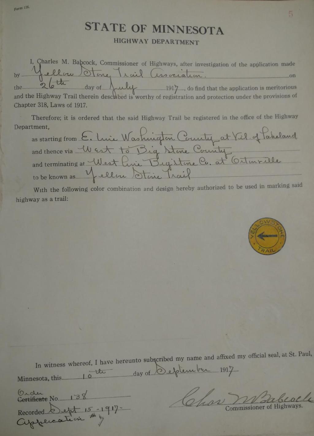
41 36

42 From the MNHS Files of the Highway Department, Registered Trails Correspondence, comes the application that generated the Commissioner of Highways Order: 37

43 38

44 39

45 APPENDIX B: 1926 LETTER TO HON. C. H. KLEIN OF CHASKA This letter is included to show that in 1926 the Yellowstone Trail continued its route through Waconia, but it also demonstrates the sensitivity to the notion of rerouting the trail. (Minnesota Historical Society, Registered Trails Correspondence.) 40

46 APPENDIX C: 1917 NO GOOD REASON FOR NARROW BUNKS ON SLEIGHS This letter from the State Highway Engineer to Yellowstone Trail Association officials illustrates what a watershed moment had occurred in 1917, when horse and sleigh travel had just given way to motorized transportation. The State Engineer argued that it made no sense to continue to have two standard gauges of road tracks to accommodate narrow and wide sleighs. There was no good reason for narrow bunks on sleighs at this time, he emphasized. (Minnesota Historical Society, Registered Trail Correspondence.) 41


47 APPENDIX D: YELLOWSTONE TRAIL 1921 ROUTE FOLDER Page 22 describes Lake Waconia as one of the most beautiful lakes in the state of Minnesota. (Minnesota Historical Society, Pamphlets Related to Roads in Minnesota, call no. HE341-HE372, 2 folders.) 42
AD Table 1.--Goodrich Evacuation Systems Installed on Certain Boeing Model Airplanes. Having any serial number (S/N) -
 -") Table 1.--Goodrich Evacuation Systems Installed on Certain Boeing Model Airplanes (i) 101623-303 (ii) 101630-305 (iii) 101630-306 (iv) 101655-305 (v) 101655-306 (vi) 101656-305 (vii) 101656-306 (viii)
Table 1.--Goodrich Evacuation Systems Installed on Certain Boeing Model Airplanes (i) 101623-303 (ii) 101630-305 (iii) 101630-306 (iv) 101655-305 (v) 101655-306 (vi) 101656-305 (vii) 101656-306 (viii)
Raft Island Gig Harbor, Washington
 RIIA Special Committee for the placement of Speed Controls Raft Island Gig Harbor, Washington Speed Control Placement and Road Safety Recommendations Date: September 14, 2017 Prepared for: RIIA Board Members
Section II. Planning & Public Process Planning for the Baker/Carver Regional Trail began in 2010 as a City of Minnetrista initiative.
 Section II Planning & Public Process Planning for the began in 2010 as a City of initiative. city staff began discussions with the Park District on the possibility of a north/south regional trail connection
Planning Commission Meeting Minutes Thursday, January 22, 2009 City Council Chambers 220 East Morris Avenue Time: 7:00 p.m.
 Planning Commission Meeting Minutes Thursday, January 22, 2009 City Council Chambers 220 East Morris Avenue Time: 7:00 p.m. Commission Members Present: Francis Lilly- Conducting Lloyd Anderson Joshua Smith
DRAFT GENERAL IMPLEMENTATION PLAN AND SPECIFIC IMPLEMENTATION PLAN MIDDLETON MUNICIPAL AIRPORT MOREY FIELD. Revised 12/12/03
 DRAFT GENERAL IMPLEMENTATION PLAN AND SPECIFIC IMPLEMENTATION PLAN MIDDLETON MUNICIPAL AIRPORT MOREY FIELD Revised 12/12/03 As recommended for approval by the Plan Commission General Project Description
Implementation Policy on. the Qualified Project Etc. for Fukuoka Airport Operation
 (TRANSLATION) (for Reference Only) Implementation Policy on the Qualified Project Etc. for Fukuoka Airport Operation The original of this document shall be prepared in Japanese language, and this is the
Finding Aid for Series F David Thompson's boundary survey maps prepared under Articles VI and VII of the Treaty of Ghent
 Finding Aid for Series F 3-5 David Thompson's boundary survey maps prepared under Articles VI and VII of the Treaty of Ghent How to order records: Using the table below, identify the map you would like
VICTORIAN BASKETBALL REFEREES ASSOCIATION - KILSYTH BRANCH. Technical Officials Committee. Constitution. September 2013
 VICTORIAN BASKETBALL REFEREES ASSOCIATION - KILSYTH BRANCH Technical Officials Committee Constitution September 2013 As endorsed by the Kilsyth Basketball Technical Officials Committee at its meeting held
Philadelphia (Pa.). City Council. Petitions to the Select and Common Councils
. City Council. Petitions to the Select and Common Councils") Philadelphia (Pa.). City Council. Petitions to the Select and Common Councils 1783-1868 (bulk 1800-1821) 2 boxes, 0.8 lin. ft. Contact: 1300 Locust Street, Philadelphia, PA 19107 Phone: (215) 732-6200
Philadelphia (Pa.). City Council. Petitions to the Select and Common Councils 1783-1868 (bulk 1800-1821) 2 boxes, 0.8 lin. ft. Contact: 1300 Locust Street, Philadelphia, PA 19107 Phone: (215) 732-6200
National Wilderness Steering Committee
 National Wilderness Steering Committee Guidance White Paper Number 1 Issue: Cultural Resources and Wilderness Date: November 30, 2002 Introduction to the Issue Two of the purposes of the National Wilderness
ASSEMBLY 35TH SESSION
 A35-WP/40 17/06/04 English only ASSEMBLY 35TH SESSION EXECUTIVE COMMITTEE Agenda Item 17: Enhancement of ICAO standards HARMONIZING STATES REGULATIONS FOR INTERNATIONAL FRACTIONAL OWNERSHIP OPERATIONS
2.2 For these reasons the provision of tourist signing will only be considered:
 TOURIST SIGNING POLICY 2015 1. DEFINITION 1.1 A tourist destination is defined as a permanently established attraction which attracts or is used by visitors to an area and is open to the public without
CHAPTER 61 SHEBOYGAN COUNTY MEMORIAL AIRPORT
 61.01 OPERATION OF AIRPORT 61.02 DEFINITION OF WORDS AND PHRASES 61.03 AIRPORT OPERATION POLICIES 61.04 UTILITIES 61.05 ENTRANCES 61.06 SPECIAL VARIANCE 61.07 ENFORCEMENT 61.08 PENALTY 61.09 MULTIPLE OWNERSHIP
HISTORY AND REVIEW OF RAILWAY-HIGHWAY GRADE CROSSING WARNING SYSTEMS AND THE GENESIS OF STANDARD SPECIFICATION
 HISTORY AND REVIEW OF RAILWAY-HIGHWAY GRADE CROSSING WARNING SYSTEMS AND THE GENESIS OF STANDARD SPECIFICATION H ugh Kendall General Railway Signal Company IN T R O D U C T IO N Warning systems at railroad/highway
Metropolitan Parks and Open Space Commission Subject District(s), Member(s): Policy/Legal Reference: Staff Prepared/Presented: Division/Department:
, Member(s): Policy/Legal Reference: Staff Prepared/Presented: Division/Department:") Business Item Metropolitan Parks and Open Space Commission Meeting date: May 20, 2013 Subject: Proposed System Addition Discussion for the 2040 Regional Parks Policy Plan District(s), Member(s): All Policy/Legal
Business Item Metropolitan Parks and Open Space Commission Meeting date: May 20, 2013 Subject: Proposed System Addition Discussion for the 2040 Regional Parks Policy Plan District(s), Member(s): All Policy/Legal
Thursday, November 1, :30 P.M. Bear Creek Senior/Recreation Center, 54 McDonough Street, Hampton, Georgia. Meeting Agenda (See Attached Agenda)
") Minutes SPLOST V Committee Thursday, November 1, 2018 6:30 P.M. Bear Creek Senior/Recreation Center, 54 McDonough Street, Hampton, Georgia The Henry Herald was notified of the meeting via email. I. Call
Minutes SPLOST V Committee Thursday, November 1, 2018 6:30 P.M. Bear Creek Senior/Recreation Center, 54 McDonough Street, Hampton, Georgia The Henry Herald was notified of the meeting via email. I. Call
Aviation, Rail, & Trucking 6-1
 6-1 This chapter describes the services, facilities, and condition of air, rail, and trucking as components of the transportation system. These three intermodal areas have an impact on the factors to be
(a) This airworthiness directive (AD) is effective April 28, 2008.
 This airworthiness directive (AD) is effective April 28, 2008.") 2008-06-27 Goodrich (Formerly BFGoodrich): Amendment 39-15439 Docket No FAA-2007-28370; Directorate Identifier 2003-NM-239-AD Effective Date (a) This airworthiness directive (AD) is effective April 28,
2008-06-27 Goodrich (Formerly BFGoodrich): Amendment 39-15439 Docket No FAA-2007-28370; Directorate Identifier 2003-NM-239-AD Effective Date (a) This airworthiness directive (AD) is effective April 28,
An Unclaimed Intangible Property Program for Ontario
 for Ontario Introduction A wide variety of intangible property currently lies unclaimed in various institutions in Ontario. The 2012 Ontario Budget announced the government s intention to establish a program
March 4, Mr. H. Dale Hemmerdinger Chairman Metropolitan Transportation Authority 347 Madison Avenue New York, NY Re: Report 2007-F-31
 THOMAS P. DiNAPOLI STATE COMPTROLLER 110 STATE STREET ALBANY, NEW YORK 12236 STATE OF NEW YORK OFFICE OF THE STATE COMPTROLLER March 4, 2008 Mr. H. Dale Hemmerdinger Chairman Metropolitan Transportation
The easyjet spoof commercial, making fun of British Airways. Taken from April 29, 2012
 Appendices Appendix 1... ii Appendix 2... iii Appendix 3... iv Appendix 4... v Appendix 5... vi Appendix 6...vii Appendix 7... viii Appendix 8...ix Appendix 9... x Appendix 10...xi Appendix 11... xii Appendix
How Roads Were Named in Washtenaw County.
 How Roads Were Named in Washtenaw County. In cities and villages there was a need that the streets be named and this was quite likely attended to by the local council or governing body early on. Even the
CITY OF CHASKA PEDESTRIAN MOVEMENT / TRAILS PLAN FINAL CHAPTER 7 PEDESTRIAN MOVEMENT / TRAILS PLAN. Page 1 of 19, Chapter 7
 FINAL CHAPTER 7 PEDESTRIAN MOVEMENT / TRAILS PLAN Page 1 of 19, Chapter 7 ORDER OF CONTENTS I. INTRODUCTION... 3 II. PURPOSE... 3 III. 2030 COMMUNITY TRAILS SYSTEM PLAN... 4 IV. TRAIL TYPES... 7 A. Regional
City of Durango 5.8 FUNDING TRAILS DEVELOPMENT
 5.8 FUNDING TRAILS DEVELOPMENT The City has been successful in establishing dedicated local funding sources as well as applying for grants to develop the City s trail system, having received nearly $2.4
Mankato s Transportation Heritage
 Mankato s Transportation Heritage City of Mankato Mankato Heritage Preservation Commission May 11, 2017 1. Union Depot, 112 S. Riverfront Drive, c. 1896. The railroads were Mankato s dominant transportation
Section moves to amend H.F. No as follows: 1.2 Delete everything after the enacting clause and insert:
 1.1... moves to amend H.F. No. 1553 as follows: 1.2 Delete everything after the enacting clause and insert: 1.3 "Section 1. Minnesota Statutes 2016, section 256B.0625, subdivision 17, is amended to 1.4
ASSEMBLY 35 th SESSION. Agenda Item: No.17, Enhancement of ICAO Standards
 A35-WP/ XXXX ASSEMBLY 35 th SESSION Agenda Item: No.17, Enhancement of ICAO Standards Harmonizing States Regulations for International Fractional Ownership Operations (Presented by the International Business
4. The Council s LTCCP decision on 30 June 2009 confirmed the extended tram route and funding.
 145 11. TRAM EXTENSION PROJECT PROPOSED PARKING CHANGES AND STREET MODIFICATIONS IN LICHFIELD STREET, MANCHESTER STREET, HIGH STREET, TUAM STREET, ASH STREET, BEDFORD ROW AND OXFORD TERRACE General Manager
National Register of Historic Places Multiple Property Documentation Form
 NPS Form 10-900-b OMB No. 1024-0018 Revised Aug. 2002 Expires 12-31-2005 Multiple Property Documentation Form This form is for use in documenting multiple property groups relating to one or several contexts.
FNORTHWEST ARKANSAS WESTERN BELTWAY FEASIBILITY STUDY
 FNORTHWEST ARKANSAS WESTERN BELTWAY FEASIBILITY STUDY EXECUTIVE SUMMARY The 2030 Northwest Arkansas Regional Transportation Plan developed by the Northwest Arkansas Regional Planning Commission (NWARPC)
LEAGUE OF CALIFORNIA. City Attorneys Department 2003 ANNUAL CONFERENCE. Joint City Attorney/City Clerks Session
 LEAGUE OF CALIFORNIA City Attorneys Department 2003 ANNUAL CONFERENCE Joint City Attorney/City Clerks Session 1 UPDATING A RECORDS RETENTION SCHEDULE DETERMINE THE NEED Updating a records retention schedule
Section 1: Vocabulary. Be able to determine if the word in bold is used correctly in a sentence.
 Section 1: Vocabulary. Be able to determine if the word in bold is used correctly in a sentence. Hardships: difficult conditions or situations that cause discomfort and/or suffering Pioneers: the people
Cascade River State Park Management Plan Amendment
 This document is made available electronically by the Minnesota Legislative Reference Library as part of an ongoing digital archiving project. http://www.leg.state.mn.us/lrl/lrl.asp Cascade River State
APPENDIX A1. NATIONAL TRAILS SYSTEM
 APPENDIX A1. NATIONAL TRAILS SYSTEM Acts of October 2, 1968 (PL 90-543), Nov. 10, 1978, March 28, 1983 (PL 98-11), Dec. 11, 1987 (PL 100-187), Oct. 4, 1988 (PL 100-470), 2006 (PL 109-418). 16 USC 1241-1251.
DATE: Wednesday, July 31, ACTION: Interim rule with request for comments.
 FEDERAL REGISTER Vol. 67, No. 147 Rules and Regulations DEPARTMENT OF JUSTICE (DOJ) Immigration and Naturalization Service (INS) 8 CFR Parts 204, 245 and 299 [INS No. 2104-00] RIN 1115-AGOO Allowing in
National Park Service Wilderness Action Plan
 National Park Service U.S. Department of the Interior National Park Service Wilderness Action Plan National Wilderness Steering Committee National Park Service "The mountains can be reached in all seasons.
FILE NO. ANMICALGIC-1
 MUNICIPAL GOVERNMENT BOARD FILE NO. ANMICALGIC-1 IN TEE MATTER OF THE "Municipal Government Act" AND IN THE MATTER OF an application by the City of Calgary, in the Province of Alberta, to annex certain
TOURISM & PUBLIC SERVICES RURAL SIGNAGE POLICY
 Policy and Procedures Subject Title: Tourism and Public Services Rural Signage Policy Corporate Policy (Approved by Council): X Policy Ref. No.: ROADS-01-07 Administrative Policy (Approved by CAO): By-Law
The Highway as a Public Forum: Effects on Safety and Operations
 The Highway as a Public Forum: Effects on Safety and Operations Louisiana Transportation Engineering Conference February 14, 2007 Steven C. Strength, P.E. District Traffic Operations Engineer LADOTD District
CAIRNGORMS NATIONAL PARK BOUNDARY BILL
 These documents relate to the Cairngorms National Park Boundary Bill (SP Bill 72) as introduced in the Scottish Parliament on 21 September 2006 CAIRNGORMS NATIONAL PARK BOUNDARY BILL EXPLANATORY NOTES
Administration Policies & Procedures Section Commercial Ground Transportation Regulation
 OBJECTIVE METHOD OF OPERATION Definitions To promote and enhance the quality of Commercial Ground Transportation, the public convenience, the safe and efficient movement of passengers and their luggage
MESA COUNTY DEPARTMENT OF PUBLIC WORKS Administration - Building - Engineering Road and Bridge Traffic - Planning - Solid Waste Management
 MESA COUNTY DEPARTMENT OF PUBLIC WORKS Administration - Building - Engineering Road and Bridge Traffic - Planning - Solid Waste Management 200 S. Spruce St. P.O. Box 20,000 Grand Junction, Colorado 81502-5022
PROPERTY TAX BULLETIN NO. 6 (Published under Appropriation No ) Issued July 1, 1992; Replaces April 1, 1983 Revision
 Issued July 1, 1992; Replaces April 1, 1983 Revision") JOHN ELIAS BALDACCI GOVERNOR STATE OF MAINE MAINE REVENUE SERVICES PROPERTY TAX DIVISION PO BOX 9106 AUGUSTA, MAINE 04332-9106 ADMINISTRATIVE & FINANCIAL SERVICES RYAN LOW COMMISSIONER MAINE REVENUE SERVICES
JOHN ELIAS BALDACCI GOVERNOR STATE OF MAINE MAINE REVENUE SERVICES PROPERTY TAX DIVISION PO BOX 9106 AUGUSTA, MAINE 04332-9106 ADMINISTRATIVE & FINANCIAL SERVICES RYAN LOW COMMISSIONER MAINE REVENUE SERVICES
TAMPERE SIGHTS IN TAMPERE AND HOURS WHEN THEY ARE OPEN. OBSERVATION TOWERS: Observation Toon Pyynikki Ridge, open 9 21 every day.
 TfImPERE TAMPERE of high class. These and the Town Orchestra are municipally supported. The Workmen's Institute will be mentioned as a free institute for the public education, where many have had the first
Vista Field Airport. Master Plan Update. February, Prepared for: Port of Kennewick One Clover Island Kennewick, Washington
 Vista Field Airport February, 2006 Prepared for: Port of Kennewick One Clover Island Kennewick, Washington 99336 Prepared by: J-U-B ENGINEERS, Inc. 2810 W. Clearwater Avenue, Suite 201 Kennewick, Washington
POLICY DCS-04: Tourism Directional Sign Policy. Development and Cultural Services
 DCS-04 Page 1 of 8 POLICY DCS-04: Tourism Directional Sign Policy Development and Cultural Services Approval Date: March 11, 2008 Approval Authority: Council, Resolution No. 7 Effective Date: March 11,
CHAPTER 4 -- THE LAND USE PLAN: DESCRIPTIONS AND POLICIES FOR THIRTEEN PLANNING AREAS
 CHAPTER 4 -- THE LAND USE PLAN: DESCRIPTIONS AND POLICIES FOR THIRTEEN PLANNING AREAS NORTH CENTRAL CAC AREA LITTLE VALLEY ROAD TO JUG HANDLE CREEK PLANNING AREA This planning area includes Cleone, Noyo,
SUMMER VILLAGE OF SILVER SANDS. Municipal Development Plan
 SUMMER VILLAGE OF SILVER SANDS Municipal Development Plan Bylaw 253-2014 Adopted August 22, 2014 Summer Village of Silver Sands Municipal Development Plan Bylaw No. 253-2014 Page 2 1 INTRODUCTION 1.1 SETTING
EXHIBIT C. GROUND TRANSPORTATION OPERATING RULES & REGULATIONS Dated August 28, Section 1 Introduction
 EXHIBIT C GROUND TRANSPORTATION OPERATING RULES & REGULATIONS Dated August 28, 2017 Section 1 Introduction The Sarasota Manatee Airport Authority has established Ground Transportation Operating Rules and
Welcome to the Illinois High-Speed Rail Chicago to St. Louis Construction Update Meeting. Today s meeting will provide an overview of the Program,
 Welcome to the Illinois High-Speed Rail Chicago to St. Louis Construction Update Meeting. Today s meeting will provide an overview of the Program, updates on construction to be held in this area, and how
Priscilla Davenport, Saluda District
 AT A MEETING OF THE MIDDLESEX COUNTY PLANNING COMMISSION HELD ON THURSDAY, NOVEMBER 13, 2003, IN THE PUBLIC MEETING ROOM OF THE COOK S CORNER OFFICE COMPLEX, COOK S CORNER, VIRGINIA. Present: Absent: John
Ordinance Number Snowmobiles and ATVs. Replaces pages See also Section County ATV Ordinance.
 Ordinance Number 05-2009 Snowmobiles and ATVs Replaces pages 900-28 - 900-29 See also Section 905.2.2 County ATV Ordinance Amended 02-15-11 ORDINANCE NO. 05-2009 WHEREAS, the use of snowmobiles and All
RV Parking Rights Hand Book
 RV Parking Rights Hand Book http://www.goodsamclub.com Residential RV parking rights are under attack in a growing number of communities across America. And more often than not, RV owners find the task
County of Elgin Tourism Signage Policy Addendum A
 1.0 INTRODUCTION County of Elgin Tourism Signage Policy Addendum A 1.1 PURPOSE OF ELGIN TOURISM SIGNAGE POLICY To define the eligibility, use, design and authority for tourism oriented directional signage
*Note: This data is preliminary and subject to change*
 *Note: This data is preliminary and subject to change* This product is an objective analysis of NWS Cooperative Observer Program (COOP) and Community Collaborative Rain, Hail and Snow Network (CoCoRaHS)
Nonemergency Medical Transportation
 This document is made available electronically by the Minnesota Legislative Reference Library as part of an ongoing digital archiving project. http://www.leg.state.mn.us/lrl/lrl.asp Nonemergency Medical
CITY COUNCIL AGENDA MEMORANDUM
 To: Mayor and City Council From: Charles Ozaki, City and County Manager Prepared By: Kevin Standbridge, Deputy City and County Manager Katie Allen, City and County Engineer David Shinneman, Community Development
Mercer Island should continue to press Renton for public input on noise and other environmental effects of the options then under consideration.
 Renton was required by the Federal Aviation Administration to complete work on its Airport Master Plan in a timely manner, the MOU adds that the noise study must be completed at the earliest time possible.
Administration Policies & Procedures Section Commercial Ground Transportation Regulation
 OBJECTIVE METHOD OF OPERATION Definitions To promote and enhance the quality of Commercial Ground Transportation, the public convenience, the safe and efficient movement of passengers and their luggage
Appendix 8: Fitted distribution parameters for ship location
 Appendix 8: Fitted distribution parameters for ship location Drogden Southbound Data Fitted Average -56-56 Stdev 56 34 Ratio,4 Registrations Mixed dist Channel borders 1 9 8 7 6 5 4 3 2 1-5 -3-1 1 3 5,12,1
METROPOLITAN COUNCIL 390 North Robert Street, St. Paul, MN Phone (651) TDD (651)
 TDD (651)") METROPOLITAN COUNCIL 390 North Robert Street, St. Paul, MN 55101 Phone (651) 602 1000 TDD (651) 291 0904 DATE: June 19, 2007 TO: Metropolitan Parks and Open Space Commission FROM: Jan Youngquist, Senior
METROPOLITAN COUNCIL 390 North Robert Street, St. Paul, MN 55101 Phone (651) 602 1000 TDD (651) 291 0904 DATE: June 19, 2007 TO: Metropolitan Parks and Open Space Commission FROM: Jan Youngquist, Senior
AIRWORTHINESS ADVISORY CIRCULAR
 GOVERNMENT OF INDIA CIVIL AVIATION DEPARTMENT DIRECTOR GENERAL OF CIVIL AVIATION AAC NO 4 of 2006 Date: 21 st August 2006 AIRWORTHINESS ADVISORY CIRCULAR SUBJECT: AIRWORTHINESS APPROVALS FOR EXPORTS 1.
Aviation Tax Report. June 30, 2016
 Aviation Tax Report June 30, 2016 Prepared by The Minnesota Department of Transportation 395 John Ireland Boulevard Saint Paul, Minnesota 55155-1899 Phone: 651-296-3000 Toll-Free: 1-800-657-3774 TTY, Voice
CHAPTER 16 STREETS, SIDEWALKS AND OTHER PUBLIC PLACES*
 CHAPTER 16 STREETS, SIDEWALKS AND OTHER PUBLIC PLACES* *Cross reference(s)--drainage commission, 2-111 et seq.; drainage districts created, 2-114; planning commission shall select and recommend to the
THRESHOLD GUIDELINES FOR AVALANCHE SAFETY MEASURES
 BRITISH COLUMBIA MINISTRY OF TRANSPORTATION & INFRASTRUCTURE AVALANCHE & WEATHER PROGRAMS THRESHOLD GUIDELINES FOR AVALANCHE SAFETY MEASURES British Columbia Ministry of Transportation & Infrastructure
Overview ICAO Standards and Recommended Practices for Aerodrome Safeguarding
 Overview ICAO Standards and Recommended Practices for Aerodrome Safeguarding References The Convention on International Civil Aviation (Chicago Convention) ICAO SARPS Annex 14 Vol. I, 7 th Edition, July
OPERATING PURPOSES AND FOR VOTED DEBT SERVICE FOR THE FISCAL YEAR BEGINNING OCTOBER 1, 2015 AND ENDING SEPTEMBER 30, SOLID WASTE ASSESSMENT
 Town of Davie Davie Town Hall: 6591 Orange Drive, Davie, Florida 33314 - Phone: 954-797-1000 REGULAR MEETING July 29, 2015 6:30 PM I. PLEDGE OF ALLEGIANCE II. III. IV. ROLL CALL OPEN PUBLIC MEETING PRESENTATIONS
If anyone would like to discuss either the questions, or the answers, with me, they are invited to contact me at
 Questionnaire 2017 Municipal Elections If anyone would like to discuss either the questions, or the answers, with me, they are invited to contact me at andrealockwoodchelsea2017@gmail.com. 1. Do you believe
West Virginia Board of Education Declaration of Intervention
 West Virginia Board of Education Declaration of Intervention WHEREAS, there is established the State Board of School Finance, pursuant to W. Va. Code 18-9B-1, etseq;and WHEREAS, pursuant to W. Va. Code
Implementation Policy on. the Qualified Project, etc., for Airport Operation of. the Four National Airports in Hokkaido
 (TRANSLATION) (for Reference Only) Implementation Policy on the Qualified Project, etc., for Airport Operation of the Four National Airports in Hokkaido The original of this document shall be prepared
MEMORANDUM OF UNDERSTANDING for the APPALACHIAN NATIONAL SCENIC TRAIL in the STATE OF NEW JERSEY
 MEMORANDUM OF UNDERSTANDING for the APPALACHIAN NATIONAL SCENIC TRAIL in the STATE OF NEW JERSEY I. BACKGROUND and OBJECTIVES The Appalachian Trail is a way, continuous from Katahdin in Maine to Springer
REVIEW OF THE STATE EXECUTIVE AIRCRAFT POOL
 STATE OF FLORIDA Report No. 95-05 James L. Carpenter Interim Director Office of Program Policy Analysis And Government Accountability September 14, 1995 REVIEW OF THE STATE EXECUTIVE AIRCRAFT POOL PURPOSE
2016 Regional Transportation Alternatives Program (TAP) Grant Application
 Grant Application") 2016 Regional Transportation Alternatives Program (TAP) Grant Application PROJECT TITLE: Yelm-Tenino Trail Extension Feasibility Study TRPC use only GENERAL PROJECT INFORMATION Agency or Organization City
2016 Regional Transportation Alternatives Program (TAP) Grant Application PROJECT TITLE: Yelm-Tenino Trail Extension Feasibility Study TRPC use only GENERAL PROJECT INFORMATION Agency or Organization City
Aircraft Maintenance Organisations - Certification. Contents
 Contents Rule objective... 3 Extent of consultation... 3 New Zealand Transport Strategy... 4 Summary of submissions... 5 Examination of submissions... 6 Insertion of Amendments... 6 Effective date of rule...
Baker/Carver Regional Trail master plan public review draft
 Baker/Carver Regional Trail master plan public review draft November 2014 the mission of Three Rivers Park District is to promote environmental stewardship through recreation and education in a natural
WEKIVA WILD AND SCENIC RIVER ACT OF 2000
 PUBLIC LAW 106 299 OCT. 13, 2000 WEKIVA WILD AND SCENIC RIVER ACT OF 2000 VerDate 11-MAY-2000 01:59 Oct 20, 2000 Jkt 069139 PO 00000 Frm 00001 Fmt 6579 Sfmt 6579 E:\PUBLAW\PUBL299.106 APPS27 PsN: PUBL299
Part 145. Aircraft Maintenance Organisations Certification. CAA Consolidation. 10 March Published by the Civil Aviation Authority of New Zealand
 Part 145 CAA Consolidation 10 March 2017 Aircraft Maintenance Organisations Certification Published by the Civil Aviation Authority of New Zealand DESCRIPTION Part 145 prescribes rules governing the certification
RESOLUTION NO
 RESOLUTION NO. 2015-15 A RESOLUTION OF THE CITY COUNCIL OF THE CITY OF MARINA AUTHORIZING SUBMISSION OF A GRANT APPLICATION TO THE FEDERAL AVIATION ADMINISTRATION (FAA) FOR PARTICIPATION IN THE 2015 MILITARY
IC Chapter 7.7. Railroad Grade Crossings Fund
 IC 8-6-7.7 Chapter 7.7. Railroad Grade Crossings Fund IC 8-6-7.7-1 "Grade crossing" Sec. 1. The term "grade crossing" as used in this chapter means a crossing of any railroad and any public highway, street
Re: Drug & Alcohol Rule Request for Extension of Compliance Date
 121 North Henry Street Alexandria, VA 22314-2903 T: 703 739 9543 F: 703 739 9488 arsa@arsa.org www.arsa.org VIA E-MAIL TO: nick.sabatini@faa.gov Associate Administrator for Aviation Safety (AVS-1) Federal
Chapter 6: POLICY AND PROCEDURE RECOMMENDATIONS
 Chapter 6 POLICY AND PROCEDURE RECOMMENDATIONS FOR SRRA Below are seven policy elements that should be considered for adoption by the Southwest Regional Recreation Authority of Virginia: 1. Develop strategies
APPROVED MINUTES Public Works Commission November 10, 2010
 APPROVED MINUTES Public Works Commission November 10, 2010 Members Present: Members Absent: Alternate Present: Staff Present: Charles Bishop, Arthur Benson, Robert Guadagno and Patrick Kinney Dean Mitchell
SUMMARY REPORT ON THE SAFETY OVERSIGHT AUDIT FOLLOW-UP OF THE DIRECTORATE GENERAL OF CIVIL AVIATION OF KUWAIT
 ICAO Universal Safety Oversight Audit Programme SUMMARY REPORT ON THE SAFETY OVERSIGHT AUDIT FOLLOW-UP OF THE DIRECTORATE GENERAL OF CIVIL AVIATION OF KUWAIT (Kuwait, 17 to 20 September 2003) International
STATE OF RHODE ISLAND AND PROVIDENCE PLANTATIONS PUBLIC UTILITIES COMMISSION
 STATE OF RHODE ISLAND AND PROVIDENCE PLANTATIONS PUBLIC UTILITIES COMMISSION IN RE: IGUS BEARINGS, INC. : DOCKET NO. 4652 PETITION FOR A PRIVATE AT-GRADE CROSSING : REPORT AND ORDER On September 30, 2016,
7:00 p.m. General meeting called to order. Paul Conte, Chair 7:05 p.m. Introductions Reminder: All JWN members should fill out and return a sign-in
 Agenda 7:00 p.m. General meeting called to order. Paul Conte, Chair 7:05 p.m. Introductions Reminder: All JWN members should fill out and return a sign-in card to receive a ballot. All guests are requested
Powder River Training Complex Special Use Airspace General & Business Aviation Survey
 Powder River Training Complex Special Use Airspace General & Business Aviation Survey February 2018 Survey and Report Completed By Aircraft Owners and Pilots Association National Business Aviation Association
AN ORDINANCE OF THE CITY COUNCIL OF THE CITY OF VACAVILLE ADDING CHAPTER 9
 Agenda Item No. January 27, 2009 TO: FROM: SUBJECT: Honorable Mayor and City Council Attention: Laura C. Kuhn, Interim City Manager Rich Word, Chief of Police Scott D. Sexton, Community Development Director
SHARK ROUTE Learning about sharks and ours oceans
 SHARK ROUTE Learning about sharks and ours oceans By Ilena Zanella and Andrés López September, 2010 SHARK ROUTE Learning about sharks and ours oceans The Shark Route is Misión Tiburón`s first project and
2017 Budget & Policy Priorities
 2017 Budget & Policy Priorities Fully Fund Minnesota State Parks and Trails No New Taxes for State Trail Users Keep State Parks Free from the Noise and Undue Artificiality of OHVs Operations Budget: Fully
Aviation Relations between the United States and Canada is Prior to Negotiation of the Air Navigation Arrangement of 1929
 Journal of Air Law and Commerce Volume 2 1931 Aviation Relations between the United States and Canada is Prior to Negotiation of the Air Navigation Arrangement of 1929 Stephen Latchford Follow this and
112th CONGRESS. 1st Session H. R. 113 IN THE HOUSE OF REPRESENTATIVES
 HR 113 IH 112th CONGRESS 1st Session H. R. 113 To provide for additions to the Cucamonga and Sheep Mountain Wilderness Areas in the Angeles and San Bernardino National Forests and the protection of existing
Environmental Assessment. Application
 Environmental Assessment Application For A Proposal To Enhance the Tourism Potential On The Burin Peninsula By Creating a Multi-use Ecotourist Trail Loop That Will Be Linked to the Newfoundland T Railway
Securing Permanent Protection for Public Land
 Securing Permanent Protection for Public Land Tools for Wyoming Advocates Paul Spitler* The Wilderness Society * I am a wilderness policy expert, not a powerpoint expert! Platform and Resolutions of the
Arthur Carhart National Wilderness Training Center s Wilderness Investigations High School
 Arthur Carhart National Training Center s Investigations High School 101/Lesson 2 (OPTION 2B) Introducing the Act Goal: Students will understand the difference between wild spaces and federally designated
Business Growth (as of mid 2002)
") Page 1 of 6 Planning FHWA > HEP > Planning > Econ Dev < Previous Contents Next > Business Growth (as of mid 2002) Data from two business directories was used to analyze the change in the number of businesses
Page 1 of 6 Planning FHWA > HEP > Planning > Econ Dev < Previous Contents Next > Business Growth (as of mid 2002) Data from two business directories was used to analyze the change in the number of businesses
NATIONAL PARK SERVICE CERTIFICATION OF COMPLETED SEGMENTS OF THE NORTH COUNTRY NATIONAL SCENIC TRAIL
 NATIONAL PARK SERVICE CERTIFICATION OF COMPLETED SEGMENTS OF THE NORTH COUNTRY NATIONAL SCENIC TRAIL Completed trail segments that (1) follow the route identified in the 1982 National Park Service (NPS)
SUPPLEMENTAL NOTE ON HOUSE SUBSTITUTE FOR SENATE BILL NO. 70
 SESSION OF 2017 SUPPLEMENTAL NOTE ON HOUSE SUBSTITUTE FOR SENATE BILL NO. 70 As Recommended by House Committee on Federal and State Affairs Brief* House Sub. for SB 70 would enact law and amend the Kansas
DD FORM 3009, FEB 2016 REPLACES DA FORM 1247, WHICH IS OBSOLETE. Page 1 of 6 Pages Adobe Professional X
 ROUTE CLASSIFICATION For use of this form, see ATP 3-34.81/MCWP 3-17.4; the proponent agency is TRADOC. SECTION I 1. SERIAL NUMBER 2. TO 3. FOR INFORMATION 4. DATE/TIME GROUP 5. NUMBER OF SHEETS OR ENCLOSURES
Implementation Policy on. the Qualified Project, etc., for Kumamoto Airport Operation
 (TRANSLATION) (for Reference Only) Implementation Policy on the Qualified Project, etc., for Kumamoto Airport Operation The original of this document shall be prepared in Japanese language, and this is
Guide to MS 28. City of Phoenix Transportation Records, Bulk Dates linear feet, 6 inches. Prepared by Lisa Gezelter June 1998
 Guide to MS 28 City of Phoenix Transportation Records, 1889-1972 Bulk Dates 1889-1959 5 linear feet, 6 inches Prepared by Lisa Gezelter June 1998 Donations by Larry Fleming in 1981 and by Joseph Smith