Metropolitan Parks and Open Space Commission Subject District(s), Member(s): Policy/Legal Reference: Staff Prepared/Presented: Division/Department:
|
|
|
- Hector Lindsey
- 6 years ago
- Views:
Transcription
1 Business Item Metropolitan Parks and Open Space Commission Meeting date: May 20, 2013 Subject: Proposed System Addition Discussion for the 2040 Regional Parks Policy Plan District(s), Member(s): All Policy/Legal Reference: MN Statute Staff Prepared/Presented: Jan Youngquist AICP, Planning Analyst ( ) Raintry Salk PhD, Senior Parks Researcher ( ) Arne Stefferud, Manager ( ) Division/Department: Community Development/Regional Parks and Natural Resources Proposed Action That the Metropolitan Council add the proposed County Road 41 Regional Trail Search Corridor to the Regional Parks System as part of the 2040 Regional Parks Policy Plan. Background Minnesota Statute , Subd. 1 requires the Metropolitan Council to prepare and adopt a longrange system policy plan for the regional recreation open space system as part of the Council s Metropolitan Development Guide. As per Statute, the 2040 Regional Parks Policy Plan will: Identify generally the areas which should be acquired to provide a system of regional recreation open space Estimate the costs of the recommended acquisition and development Minnesota Statute , Subd. 14 defines regional recreation open space as land and water areas, or interests therein, and facilities determined by the Metropolitan Council to be of regional importance in providing for a balanced system of public outdoor recreation for the metropolitan area, including but not limited to park reserves, major linear parks and trails, large recreation parks, and conservatories, zoos, and other special use facilities. Council staff conducted one-on-one meetings with each of the regional park implementing agencies in December 2013, primarily to discuss the Thrive MSP 2040 equity directive. At these individualized meetings, Council staff asked whether the implementing agencies had any proposed additions to the Regional Parks System to be considered as part of the development of the 2040 Regional Parks Policy Plan. The implementing agencies were notified in early April that the proposed system addition requests were due by April 30. Two agencies, Carver County and Three Rivers Park District, submitted proposals by the due date. Proposals received after the due date are not being brought forward for consideration. Carver County has proposed that two regional trail search corridors, totaling 8.5 miles, be considered for addition to the regional parks system. The estimated cost to acquire and develop these trails is $2,750,000 in 2014 dollars. Three Rivers Park District has proposed that 12 regional trail search corridors, totaling 145 miles, be considered for addition to the Regional Parks System. The estimated cost to acquire and develop these trails is $80,500,000 in 2014 dollars. Page - 1
2 Staff analysis of the Carver County proposed trail corridors is included in Attachment A. Staff analysis of the Three Rivers Park District proposed trail corridors will be presented at the June 3 MPOSC meeting. Rationale Minnesota Statute states that the Metropolitan Council shall consult with and make maximum use of the expertise of the Metropolitan Parks and Open Space Commission in preparing the policy plan. Funding The addition of regional trail search corridors to the Regional Parks System as part of the 2040 Regional Parks Policy Plan does not commit the Council to funding. In order to be eligible for regional parks funding, a master plan for each regional trail corridor must be approved by the Council. Future funding based on the approved master plan may be awarded through the Regional Parks Capital Improvement Program (CIP) and Park Acquisition Opportunity Fund. Council action is required to approve the CIP and to approve specific grants to the regional park implementing agencies. Known Support / Opposition The Carver County Board of Commissioners supported the proposal to add the County Road 41 and the County Road 61 Regional Trail Search Corridors to the Regional Parks System as part of the 2040 Regional Parks Policy Plan at its April 20 Board work session. Page - 2 METROPOLITAN COUNCIL
3 Attachment A: Analysis of Proposed System Additions As of 2013, the Regional Parks System consisted of 40 regional parks, 12 park reserves, seven special recreation features and 308 miles of regional trails that are open to the public. There are four regional parks, one park reserve and one special recreation feature that have Council-approved master plans but are not yet developed or open to the public, which include: Doyle Kennefick Regional Park Scott County Grey Cloud Island Regional Park Washington County Lake Sarah Regional Park Three Rivers Park District Whitetail Woods Regional Park Dakota County Blakeley Bluffs Park Reserve Scott County Grey Cloud Island Park Reserve Washington County Kingswood Special Recreation Feature Three Rivers Park District The 2030 Regional Parks Policy Plan also identified a regional park search area in Anoka County and two regional park search areas in Carver County which have not yet been planned. A regional park study area exists in northern Dakota County the Council indicated that it would evaluate the feasibility of combining three local parks Thompson County Park, Kaposia Park and Kaposia Landing into one regional park unit. Figure 1 shows the regional trail miles open to the public in 2013 for each regional park implementing agency. The 2012 estimated population is shown for comparative purposes. Figure 1: Existing Regional Trail Miles by Regional Park Implementing Agency (2013) Regional Park Implementing Agency Existing Regional Trail Miles (2013) 2012 Estimated Population Anoka County ,426 Carver County ,602 Dakota County ,609 Minneapolis Park & Recreation Board ,156 Ramsey County ,943 Scott County ,020 St. Paul ,734 Three Rivers Park District ,502 Washington County ,695 TOTAL ,851,687 Source: Trails Miles reported by Regional Park Implementing Agency 2012 Estimated Population Metropolitan Council Page - 3 METROPOLITAN COUNCIL
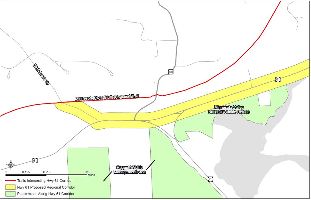
4 The 2030 Regional Parks Policy Plan places a strong emphasis on regional trail search corridors and ambitiously plans to expand the regional trail network from 300 miles to 1,000 miles. A map of the 2030 Regional Parks System Plan is shown in Attachment B. The mapping symbology has been changed from what is found in the 2030 Regional Parks System Plan to ease reading. All regional trails that are not open to the public or do not have a Metropolitan Council approved master plan are shown as orange regional trail search corridors. All regional park search areas are shown with a red circle and the regional park study area is shown with a blue circle. In accordance with State Statute, additions of land and water areas to the Regional Parks System must be determined by the Metropolitan Council to be of regional importance in providing for a balanced system of public outdoor recreation. The Regional Parks System, together with State facilities, should reasonably meet the outdoor recreation needs of the people of the metropolitan area. Regional Parks System facilities (in accordance with its Council-approved master plan) are eligible for regional parks funding, which is comprised of State funds and Council bonds. In order for State and regional dollars to be invested in recreational facilities, they must be of regional importance as determined by the Metropolitan Council. Carver County Proposals: Carver County has proposed two regional trail search corridors for inclusion in the Regional Parks System as part of the 2040 Regional Parks Policy Plan: the County Road 41 Regional Trail Search Corridor and the County Road 61 Regional Trail Search Corridor. Attachment C shows the 2030 Regional Parks System Plan Map with the proposed regional trail search corridors. Attachments D and E focus the map on the proposed regional trail search corridors in Carver County. The proposed County Road 41 Regional Trail Search Corridor is approximately 7.5 miles long and generally follows County Road 41 from the Minnesota Valley State Recreation Area and National Wildlife Refuge in Chaska to Lake Minnewashta Regional Park in Chanhassen. The proposed regional trail will facilitate connections between Scott, Carver and Hennepin Counties as its connects to the Minnesota River Bluffs Regional Trail and Scott County Connection, the Southwest Regional Trail, the proposed Twin Cities & Western Regional Trail, and the proposed Highway 5 Regional Trail. The proposed County Road 41 Regional Trail will also connect to local parks and trails, the Minnesota Landscape Arboretum, the Eastern Carver County Public School District 112 complex (Chaska Elementary School, East and West Middle Schools) and the Chaska Community Center. Approximately 4 miles of the proposed regional trail are already developed. The estimated costs to acquire and develop the remaining 3.5 miles is approximately $2 million. The proposed County Road 61 Regional Trail Search Corridor is approximately 1 mile long and generally follows County Road 61 from the Minnesota River Bluffs Regional Trail in Chanhassen to the boundary between Carver and Hennepin Counties. Along its route, the proposed regional trail will connect to the proposed Highway 101 Regional Trail, the Minnesota Valley National Wildlife Refuge, the Seminary Fen wetlands complex (owned by the Minnesota Department of Natural Resources) and the State Raguet Wildlife Management Area. Opportunities for connections to a regional trail search corridor proposed by Three Rivers Park District in Hennepin County also exist. Additional information on these regional trail search corridors is included in Carver County s request letter, shown in Attachment F. Page - 4 METROPOLITAN COUNCIL
5 The 2030 Regional Parks Policy Plan outlines the following criteria for regional trails. Staff analysis is italicized. Siting and Acquisition Strategy 3: New trails, or trail segments, that serve a regional audience are a significant priority for the regional parks system. To qualify for regional trail status, an existing or proposed trail must meet the following criteria: 1. The trail should not duplicate an existing trail. The trail may include a portion of an existing county or local trail if the trail serves one of the following functions: Destination Regional Trail. Be a destination itself, providing a high-quality recreation experience that traverses significant natural resource areas where the trail treadway will have no adverse impact on the natural resource base; Linking Regional Trail. Link two or more units of the regional recreation open space system. County Road 41 Regional Trail Search Corridor: This regional trail search corridor does not duplicate an existing trail and will serve as a linking trail. The trail will link five regional parks system facilities, including four regional trails and one regional park. The regional trail search corridor includes a 4 mile portion of an existing local trail, which serves as a linking trail. County Road 61 Regional Trail Search Corridor: This regional trail search corridor does not duplicate an existing trail and will also serve as a linking trail. The trail will link two regional trails to State and Federal recreation lands, with the opportunity to link to a proposed regional trail search corridor in Hennepin County. The regional trail corridor does not include any existing local trail segments, although the 2014 Trunk Highway 101 bridge project will construct approximately.5 mile of the trail along County Road 61 in Carver County. 2. The trail must serve a regional audience based on visitor origin and service-area research on regional trails. County Road 41 Regional Trail Search Corridor: Service area research on regional trails shows that the primary service area lies within 2-3 miles on either side of a trail corridor. The proposed County Road 41 Regional Trail, along with the connections it makes to other regional parks and trails, will facilitate a connection from Carver County to both Scott and Hennepin Counties. The proposed regional trail also will make connections to State and Federal recreation lands. Therefore, the County Road 41 Regional Trail will likely serve a regional audience. County Road 61 Regional Trail Search Corridor: The proposed County Road 61 Regional Trail will travel between Carver County and Hennepin County. The trail will link to the Trunk Highway 101 bridge that is being constructed over the Minnesota River between Carver and Scott Counties. Three Rivers Park District has proposed a regional trail search corridor in Hennepin County that will connect to the County Road 61 Regional Trail Search Corridor. If both of these regional trail search corridors are added to the Regional Parks System, the County Road 61 Regional Trail will likely serve a regional audience. Page - 5 METROPOLITAN COUNCIL
6 3. New linking regional trails should be located in the developing or developed area of the region. For Linking Regional Trails, any two trails running parallel to each other and not separated by natural or human-built barriers should be at least 1.5 miles apart so as not to overlap the localized service area of those trails. For Destination Regional Trails or Greenways, there should be no spacing minimums or maximums; instead, the decision to locate a trail should be based on the availability of high quality natural resources or the opportunity for natural resources restoration, enhancement and protection. County Road 41 Regional Trail Search Corridor: This linking regional trail will travel through Chaska and Chanhassen, which have been classified as a developing communities by the Metropolitan Council s 2030 Regional Development Framework. The draft Thrive MSP 2040 has classified Chaska as a Suburban Edge community and Chanhassen as an Emerging Suburban Edge community. The criteria for linking trails in the 2030 Regional Parks Policy Plan is based on the geographic planning areas from the 2030 Regional Development Framework. As part of the development of the 2040 Regional Parks Policy Plan, the criteria will be revised to correspond to the community designations put forward in Thrive MSP In downtown Chaska, the proposed County Road 41 Regional Trail and the planned Southwest Regional Trail will be within.25 mile of one another. However, the County Road 41 Regional Trail will travel straight north to connect to Lake Minnewashta Regional Park, while the Southwest Regional Trail will travel northwest to connect to Carver Park Reserve. Most of the two trail corridors are not parallel to one another and are farther than 1.5 miles apart. County Road 61 Regional Trail Search Corridor: This linking regional trail will travel through Chanhassen, which has been classified as developing community by the Metropolitan Council s 2030 Regional Development Framework and as an Emerging Suburban Edge community by Thrive MSP The proposed County Road 61 Regional Trail runs somewhat parallel to the Minnesota River Bluffs Regional Trail; however, the Minnesota River Bluffs Regional Trail travels northeast to Hopkins. If the connecting regional trail search corridor proposed by Three Rivers Park District in Hennepin County is approved, the proposed County Road 61 Regional Trail will travel east through Eden Prairie. Therefore, the majority of the two trail corridors are not parallel to one another and are father than 1.5 miles apart. Conclusion The proposed County Road 41 Regional Trail Search Corridor meets the criteria outlined in the 2030 Regional Parks Policy Plan for a linking regional trail. Based on its connections to regional parks system facilities, including those in Hennepin and Scott Counties, as well as connections to State and Federal recreation lands, the proposed County Road 41 Regional Trail Search Corridor should be deemed of regional importance and included as part of the Regional Parks System in the 2040 Regional Parks Policy Plan. The proposed County Road 61 Regional Trail Search Corridor may meet the criteria outlined in the 2030 Regional Parks Policy Plan for a linking regional trail if the regional trail search corridor proposed by Three Rivers in Hennepin County is approved. Therefore, a staff recommendation on this proposed corridor will be made along with the analysis of the Three Rivers Park District proposals at the June 3 MPOSC meeting. Page - 6 METROPOLITAN COUNCIL

7 Attachment B: 2030 Regional Parks System Plan Map Page - 7

8 Attachment C: Page - 8 METROPOLITAN COUNCIL

9 Attachment D: Page - 9 METROPOLITAN COUNCIL

10 Attachment E: Page - 10 METROPOLITAN COUNCIL

11 Attachment F: Request Letter from Carver County Page - 11

12 Page - 12 METROPOLITAN COUNCIL
13 Page - 13 METROPOLITAN COUNCIL

14 Page - 14 METROPOLITAN COUNCIL
15 Page - 15
Committee Report. Community Development Committee For the Metropolitan Council meeting of April 13, Business Item No.
 Committee Report Business Item No. 2016-48 Community Development Committee For the Metropolitan Council meeting of April 13, 2016 Subject: Harriet Island-South St. Paul Regional Trail Master Plan, Saint
Community Development Committee
 C Community Development Committee For the Metropolitan Council meeting of October 31, 2012 Committee Report Item:2012-316 ADVISORY INFORMATION October 16, 2012 Date Prepared: Subject: Intercity Regional
Business Item No XXX. Proposed Action That the Metropolitan Council approve the Coon Creek Regional Trail Master Plan.
 Business Item No. 2015-XXX Metropolitan Parks and Open Space Commission Meeting date: July 7, 2015 For the Community Development Committee meeting of July 20, 2015 For the Metropolitan Council meeting
Committee Report. Community Development Committee For the Metropolitan Council meeting of August 12, Business Item No.
 Committee Report Business Item No. 2015-168 Community Development Committee For the Metropolitan Council meeting of August 12, 2015 Subject: Coon Creek Regional Trail Master Plan, Anoka County Proposed
Webinar Series for Comprehensive Plan Updates. Making Your Plan a Walk in the Park
 Webinar Series for Comprehensive Plan Updates Making Your Plan a Walk in the Park Presented by Jan Youngquist and Michael Peterka September 15, 2016 Today s Presentation Importance of Parks and Trails
Business Item No
 Metropolitan Parks and Open Space Commission Meeting date: February 6, 2018 For the Community Development Committee meeting of February 20, 2018 For the Metropolitan Council meeting of February 28, 2018
METROPOLITAN COUNCIL 390 North Robert Street, St. Paul, MN Phone (651) TDD (651)
 TDD (651)") DATE: March 27, 2012 METROPOLITAN COUNCIL 390 North Robert Street, St. Paul, MN 55101 Phone (651) 602-1000 TDD (651) 291-0904 TO: Metropolitan Parks and Open Space Commission FROM: Arne Stefferud, Planning
DATE: March 27, 2012 METROPOLITAN COUNCIL 390 North Robert Street, St. Paul, MN 55101 Phone (651) 602-1000 TDD (651) 291-0904 TO: Metropolitan Parks and Open Space Commission FROM: Arne Stefferud, Planning
Summary of Committee Discussion/Questions Metropolitan Transportation Services Senior Planner Russ Owen presented this item.
 Committee Report Business Item No. 2017-191 Transportation Committee For the Metropolitan Council meeting of September 13, 2017 Subject: Final Crystal Airport 2035 Long Term Comprehensive Plan (LTCP) Proposed
Business Item No xx
 Business Item No. 2015-xx Metropolitan Parks and Open Space Commission Meeting date: April 7, 2015 For the Community Development Committee meeting of April 21, 2015 For the Metropolitan Council meeting
CITY OF CHASKA PEDESTRIAN MOVEMENT / TRAILS PLAN FINAL CHAPTER 7 PEDESTRIAN MOVEMENT / TRAILS PLAN. Page 1 of 19, Chapter 7
 FINAL CHAPTER 7 PEDESTRIAN MOVEMENT / TRAILS PLAN Page 1 of 19, Chapter 7 ORDER OF CONTENTS I. INTRODUCTION... 3 II. PURPOSE... 3 III. 2030 COMMUNITY TRAILS SYSTEM PLAN... 4 IV. TRAIL TYPES... 7 A. Regional
Three Rivers Park District
 ATTACHMENT C Regional Parks Policy Plan Update Proposed System Additions May 4, 2010 MPOSC Meeting ATTACHMENT C Three Rivers Park District Map Designation Site Name Type Conversion Acres Trail Length (miles)
Section II. Planning & Public Process Planning for the Baker/Carver Regional Trail began in 2010 as a City of Minnetrista initiative.
 Section II Planning & Public Process Planning for the began in 2010 as a City of initiative. city staff began discussions with the Park District on the possibility of a north/south regional trail connection
ACTION TRANSMITTAL
 Transportation Advisory Board of the Metropolitan Council of the Twin Cities ACTION TRANSMITTAL 2018-16 DATE: February 9, 2018 TO: Transportation Advisory Board FROM: Technical Advisory Committee PREPARED
THREE RIVERS PARK DISTRICT
 THREE RIVERS PARK DISTRICT LONG-RANGE STRATEGIC INITIATIVES COMMITTEE MEETING Administrative Center - Board Room 3000 Xenium Lane North, Plymouth, MN Thursday, July 2, 2015 Estimated Time: 9:30 10:30 a.m.
Baker/Carver Regional Trail master plan public review draft
 Baker/Carver Regional Trail master plan public review draft November 2014 the mission of Three Rivers Park District is to promote environmental stewardship through recreation and education in a natural
Cascade River State Park Management Plan Amendment
 This document is made available electronically by the Minnesota Legislative Reference Library as part of an ongoing digital archiving project. http://www.leg.state.mn.us/lrl/lrl.asp Cascade River State
INITIATIVE. Parks and Trails Legacy Funding Project. Environmental
 Parks and Trails Legacy Funding Project Recommendations from the Work Group to the Minnesota Department of Natural Resources November 2012 Prepared by Environmental INITIATIVE Environmental Initiative
Draft for approval by TCC on 2/3, TAQC on 2/9 and ARC Board on 2/22. Regional Trail Plan. Mike Alexander, Director, Center for Livable Communities
 DATE: February 3, 2017 ISSUE SUMMARY: Regional Trail Plan FROM: Mike Alexander, Director, Center for Livable Communities IMPORTANCE: In May 2016, ARC adopted the active transportation component of the
Metropolitan Parks and Open Space Commission
 Business Item No. 2013-xxx Metropolitan Parks and Open Space Commission Meeting date: November 12, 2013 For the Community Development Committee meeting of November 18, 2013 Subject: Nine Mile Creek Regional
2. Goals and Policies. The following are the adopted Parks and Trails Goals for Stillwater Township:
 D. PARKS AND TRAILS 1. Introduction Stillwater Township s population is relatively low, with most residents living on rural residences on large lots. The need for active park space has been minimal in
MINNESOTA S PARKS & TRAILS LEGACY PROGRAM: ACCOMPLISHMENTS & PROSPECTS
 MINNESOTA S PARKS & TRAILS LEGACY PROGRAM: ACCOMPLISHMENTS & PROSPECTS PAU L P U R M A N M I N N E S OTA D E PA R T M E N T O F N AT U R A L R E S O U R C E S, PA R K S & T R A I L S L EG 5/15/2016 1 A
Segment 2: La Crescent to Miller s Corner
 goal of the USFWS refuges is to conserve, protect and enhance fish, wildlife and plants and their habitats for the continuing benefit of the American people. Refuge lands are used largely for fishing,
Proposed Official Plan Amendment 41 to the Region of York Official Plan
 COMMITTEE OF THE WHOLE NOVEMBER 18, 2002 REGION OF YORK OFFICIAL PLAN AMENDMENT 41 THE OAK RIDGES MORAINE CONSERVATION PLAN Recommendation The Commissioner of Planning recommends: 1. That the City of Vaughan
2013 HOUSING COUNTS November 2014
 2013 HOUSING COUNTS November 2014 MINNEAPOLIS 2013 Affordable Units with Financing Closed New Production: Rental @30% @50% @60% AMI AMI AMI Pillsbury Historic Redevelopment... 251 *Snelling Apartments
Corridor Management Committee Meeting. April 2, 2014
 Corridor Management Committee Meeting April 2, 2014 1 Today s Topics Welcome Approval of Minutes Resolutions Response to March 26 CMC Questions Staff Recommendation on Project Scope and Budget Public Testimony
Rule Governing the Designation and Establishment of All-Terrain Vehicle Use Trails on State Land
 Rule Governing the Designation and Establishment of All-Terrain Vehicle Use Trails on State Land 1.0 Authority 1.1 This rule is promulgated pursuant to 23 V.S.A. 3506. Section 3506 (b)(4) states that an
MEETING OF THE METROPOLITAN PARKS AND OPEN SPACE COMMISSION Tuesday, April 4, 2017
 Minutes of the MEETING OF THE METROPOLITAN PARKS AND OPEN SPACE COMMISSION Tuesday, April 4, 2017 Committee Members Present: Tony Yarusso, Rick Theisen, Robert Moeller, Todd Kemery, Sarah Hietpas, Margie
2013 Airport Noise Plan of Action
 2013 Airport Noise Plan of Action Mendota Heights Airport Relations Commission Mendota Heights City Code (2-4-6) establishes the following powers and duties for the Mendota Heights Airport Relations Commission:
Metro Transit Service Improvement Plan
 Metro ransit Service Improvement Plan ransportation Committee April 13, 2015 Cyndi Harper Manager of Route Planning Kyle Burrows ransit Planner What is the Service Improvement Plan (SIP)? Bus service expansion
*Note: This data is preliminary and subject to change*
 *Note: This data is preliminary and subject to change* This product is an objective analysis of NWS Cooperative Observer Program (COOP) and Community Collaborative Rain, Hail and Snow Network (CoCoRaHS)
Service Improvement Plan
 Metro ransit Service Improvement Plan ransportation Committee April 13, 2015 Cyndi Harper Manager of Route Planning Kyle Burrows ransit Planner What is the Service Improvement Plan (SIP)? Bus service expansion
10/25/2013. What is the SCORP?! 2013 Local Government Survey 2013 Statewide Public Survey Advisory Group Priority Areas Your Suggestions!
 COLORADO OUTDOOR RECREATION TRENDS RESULTS FROM THE SCORP AND STATEWIDE Colorado Outdoor Recreation Resource Partnership September 2013 PRESENTATION What is the SCORP?! 2013 Local Government Survey 2013
Noise Oversight Committee
 Noise Oversight Committee May 8, 2014 Audio/Video recordings are made of this meeting 1 Item 1 Review and Approve Draft Meeting Minutes Minutes from March 19, 2014 2 Item 2 Review of Operations Report
CHAPTER 6 NOISE EXPOSURE
 CHAPTER 6 NOISE EXPOSURE FAA requires that the NEM submitted for review represent the aircraft noise exposure for the year of submittal (in this case 2008) and for a future year (2013 for OSUA). However,
8 CROSS-BOUNDARY AGREEMENT WITH BRAMPTON TRANSIT
 8 CROSS-BOUNDARY AGREEMENT WITH BRAMPTON TRANSIT The Transportation Services Committee recommends the adoption of the recommendations contained in the following report dated May 27, 2010, from the Commissioner
Business Item Transportation Committee SW Item:
 T Business Item Transportation Committee SW Item: 2008-167 Meeting date: June 23, 2008 For Metropolitan Council: June 25, 2008 ADVISORY INFORMATION Date: June 13, 2008 Subject: Approval of Public Hearing
METROPOLITAN COUNCIL 390 North Robert Street, St. Paul, MN Phone (651) TDD (651)
 TDD (651)") METROPOLITAN COUNCIL 390 North Robert Street, St. Paul, MN 55101 Phone (651) 602 1000 TDD (651) 291 0904 DATE: June 19, 2007 TO: Metropolitan Parks and Open Space Commission FROM: Jan Youngquist, Senior
METROPOLITAN COUNCIL 390 North Robert Street, St. Paul, MN 55101 Phone (651) 602 1000 TDD (651) 291 0904 DATE: June 19, 2007 TO: Metropolitan Parks and Open Space Commission FROM: Jan Youngquist, Senior
Southwest LRT Alignment Video Narration
 Southwest LRT Alignment Video Narration September 2015 Southwest Light Rail Transit, a proposed extension of the METRO Green Line, will serve Minneapolis, St. Louis Park, Hopkins, Minnetonka and Eden Prairie.
2030 Comprehensive Plan A Policy Guide to 2030
 2030 Comprehensive Plan A Policy Guide to 2030 Parks and Open Spaces Approved by Board of Commissioners May 26, 2009 Adopted by Board of Commissioners September 7, 2010 Washington County Mission To provide
C. APPROACH FOR IDENTIFYING THE BEST ROUTES FOR THE NEEDED TRANSMISSION SYSTEM IMPROVEMENTS
 C. APPROACH FOR IDENTIFYING THE BEST ROUTES FOR THE NEEDED TRANSMISSION SYSTEM IMPROVEMENTS CL&P s approach for identifying the best routes for the needed transmission system improvements included a determination
Flying Cloud Airport Joint Airport Zoning Board. 27 February 2018 Public Hearing #1 Overview of Proposed Airport Zoning Ordinance
 Flying Cloud Airport Joint Airport Zoning Board 27 February 2018 Public Hearing #1 Overview of Proposed Airport Zoning Ordinance Presentation Agenda Purpose & Goals Review of FCM Zoning Historical Timeline
Gophers and Vikings Service
 September 2015 Hello Riders! Are you as excited for Fall as we are? We can t wait for Gophers and Vikings football, gathering with friends around bonfires, and being able to find all our favorite foods
Subject: Lake Byllesby Regional Park Master Plan, Dakota County, Review File No
 Committee Report Business Item No. 2018-114 Community Development Committee For the Metropolitan Council meeting of May 23, 2018 Subject: Lake Byllesby Regional Park Master Plan, Dakota County, Review
REQUEST FOR PLANNING COMMISSION ACTION
 REQUEST FOR PLANNING COMMISSION ACTION DATE: 06/03/09 ITEM NO: 5e Department Approval: Agenda Section: PUBLIC HEARINGS Item Description: Request by City of Roseville for the vacation of public right-of-way
Summary for the December 3rd-4th, 2010 Snow Storm
 Summary for the December 3rd-4th, 2010 Snow Storm A widespread area of snowfall impacted southern and central Minnesota and west Central Wisconsin beginning on the morning of December 3rd that slowly tapered
2017 Budget & Policy Priorities
 2017 Budget & Policy Priorities Fully Fund Minnesota State Parks and Trails No New Taxes for State Trail Users Keep State Parks Free from the Noise and Undue Artificiality of OHVs Operations Budget: Fully
Wilderness Character and Wilderness Characteristics. What s the difference? Why does it matter?
 Introduction Wilderness Character and Wilderness Characteristics What s the difference? Why does it matter? The terms wilderness character and wilderness characteristics are sometimes used interchangeably
Metropolitan Council 2016 Population and Household Estimates Published July 2017
 Metropolitan Council 2016 and s Published July 2017 City or Township Andover 30,598 32,335 1,737 9,811 10,391 580 Anoka 17,142 17,995 853 7,060 7,436 376 Bethel 466 461-5 174 174 0 Blaine (part) 57,186
Metropolitan Council 2017 Final Population and Household Estimates Certified and published July 2018
 Metropolitan Council Final and s Certified and published July 2018 City or Township - - Andover 30,598 32,470 1,872 9,811 10,445 634 Anoka 17,142 18,205 1,063 7,060 7,525 465 Bethel 466 499 33 174 179
ECONOMIC IMPACT OF THE RELIEVER AIRPORTS
 Metropolitan Airports Commission ECONOMIC IMPACT OF THE RELIEVER AIRPORTS Prepared for Prepared by April 3, 2018 Executive Summary The Metropolitan Airports Commission engaged InterVISTAS Consulting Inc.
2014 LEGISLATIVE AGENDA
 2014 LEGISLATIVE AGENDA BONDING SESSION Working to acquire, protect and enhance critical land for the public s use and benefit. 2014 LEGISLATIVE AGENDA In preparation for each session of the Minnesota
Twin Cities Region Population and Household Estimates, 2014 (PRELIMINARY)
") and Household s, (PRELIMINARY) Andover 30,598 31,874 1,276 9,811 10,273 462 Anoka 17,142 17,586 444 7,060 7,252 192 Bethel 466 477 11 174 177 3 Blaine (part) 57,186 62,066 4,880 21,077 22,647 1,570 Centerville
and Household s, (PRELIMINARY) Andover 30,598 31,874 1,276 9,811 10,273 462 Anoka 17,142 17,586 444 7,060 7,252 192 Bethel 466 477 11 174 177 3 Blaine (part) 57,186 62,066 4,880 21,077 22,647 1,570 Centerville
DRAFT 2040 CARVER COUNTY COMPREHENSIVE PLAN
 PARKS, OPEN SPACE, & TRAILS DRAFT 2040 CARVER COUNTY COMPREHENSIVE PLAN www.co.carver.mn.us/2040plan 6. Parks, Open Space, and Trails Plan Introduction The population in is expected to increase from the
2. 1:35 to 1:50 MSP Long-Term Comprehensive Plan Update. 3. 1:50 to 2:05 Update on Runway 17 RNAV Departure Procedure 24-Hour Trial
 Minneapolis/St. Paul International Airport (MSP) Noise Oversight Committee (NOC) Meeting Agenda May 20, 2009 1:30 P.M. Lindbergh Conference Room MAC General Office Building 6040 28 th Avenue South Minneapolis,
2009 Regional Solicitation Selected Projects*
 2009 Regional Solicitation Selected Projects* Special Federal Allocation from the MPO Mn/DOT I-494/TH169 Interchange Reconstruction $34,000,000 Surface Transportation Program - Urban Guarantee AR-09-10
METRO Orange Line Update Metro Transit, BRT/Small Starts Projects Christina Morrison & Natalie Westberg Transportation Committee July 10, 2017
 METRO Orange Line Update Metro Transit, BRT/Small Starts Projects Christina Morrison & Natalie Westberg Transportation Committee July 10, 2017 Orange Line BRT Project What is the Orange Line project? 17-mile
Flying Cloud Airport (FCM) Zoning Process: Informing a Mn/DOT Path Forward
 Zoning Process: Informing a Mn/DOT Path Forward") : Informing a Mn/DOT Path Forward A Review of the Flying Cloud Airport (FCM) Joint Airport Zoning Board (JAZB) Process and the Draft Airport Zoning Ordinance B A RPZ RPZ A B C Zone Chad E. Leqve Director
: Informing a Mn/DOT Path Forward A Review of the Flying Cloud Airport (FCM) Joint Airport Zoning Board (JAZB) Process and the Draft Airport Zoning Ordinance B A RPZ RPZ A B C Zone Chad E. Leqve Director
RUSHMORE CONNECTOR TRAIL PROPOSAL
 PURPOSE AND NEED Background The U.S. Forest Service, Black Hills National Forest (Forest Service) has received a special use permit application from the State of South Dakota Department of Game, Fish and
TRANSPORTATION ADVISORY BOARD. Metropolitan Council, 390 Robert Street North, Saint Paul, Minnesota 55101
 TRANSPORTATION ADVISORY BOARD 1) Call to Order 2) Adoption of Agenda Metropolitan Council, 390 Robert Street North, Saint Paul, Minnesota 55101 NOTICE OF A MEETING of the PLANNING COMMITTEE Thursday, June
Design Charrette Public Meeting
 Design Charrette Public Meeting Citizen Advisory Committee Members of the Public November 2, 2011 - Theodore Wirth Chalet - 6:30-8:30 p.m. Park Background: Visitation Estimation 2010 Regional Visitation
Park System Development Charge Update Investment Plan
 System Development Charge Update Investment Plan I. Summary II. SDC Investments, 1998-2007 III. IV. Population Growth Projections SDC Acquisition Target s V. SDC Development Target s VI. SDC Acquisition
2016 Regional Transportation Alternatives Program (TAP) Grant Application
 Grant Application") 2016 Regional Transportation Alternatives Program (TAP) Grant Application PROJECT TITLE: Yelm-Tenino Trail Extension Feasibility Study TRPC use only GENERAL PROJECT INFORMATION Agency or Organization City
2016 Regional Transportation Alternatives Program (TAP) Grant Application PROJECT TITLE: Yelm-Tenino Trail Extension Feasibility Study TRPC use only GENERAL PROJECT INFORMATION Agency or Organization City
Appendix K: MSP Class B Airspace
 Appendix K: MSP Class B Airspace K All of the open sky covering the United States, from less than an inch off the ground all the way to outer space, is part of America s airspace. This airspace resource
Executive Summary. Need for the Study FINAL REPORT
 FINL REPORT Executive Summary The transportation system of Dakota County, Minnesota, is built around a framework of Principal rterial P highways, which are well established to the north for example, the
Committee. Presentation Outline
 CW-33-15 11/9/2015 Community and Corporate Services Committee November 10, 2015 1 Presentation Outline Background Vision and Objectives Study Process and Timeline Public and Stakeholder Engagement Organization
Section 106 Update Memo #1 Attachment D. Traffic Diversion & APE Expansion Methodology & Maps
 Section 106 Update Memo #1 Attachment D Traffic Diversion & APE Expansion Methodology & Maps I-65/I-70 North Split Interchange Reconstruction Project (Des. Nos. 1592385 & 1600808) Traffic Diversion and
CITY OF VAUGHAN EXTRACT FROM COUNCIL MEETING MINUTES OF JANUARY 25, 2011
 Item 1, Report No. 1, of the Priorities and Key Initiatives Committee, which was adopted without amendment by the Council of the City of Vaughan on January 25,. 1 RAPID TRANSIT UPDATE TORONTO-YORK SPADINA
The Chu property is a 6.57 acre parcel located in the Town of Superior on the west side of McCaslin Boulevard. In 2014, the Town of Superior acquired
 1 The Chu property is a 6.57 acre parcel located in the Town of Superior on the west side of McCaslin Boulevard. In 2014, the Town of Superior acquired the Chu property for open space with a contribution
Blueways: Rivers, lakes, or streams with public access for recreation that includes fishing, nature observation, and opportunities for boating.
 Parks, Open Space and Trails PRINCE WILLIAM COUNTY 2008 COMPREHENSIVE PLAN TRAILS PLAN CONTENTS The components of the trails plan are: Intent Definitions Goals, Policies, and Action Strategies Trails Map
DRAFT MINUTES PARKS AND RECREATION COMMISSION CITY OF CUPERTINO
 DRAFT MINUTES PARKS AND RECREATION COMMISSION CITY OF CUPERTINO Regular Meeting March 1, 2012 at 7:00 p.m. Community Hall, 10350 Torre Avenue, Cupertino, CA Note: This meeting will be televised ATTACHMENT
Final Environmental Impact Statement for the Merced Wild and Scenic River. Comprehensive Management Plan, Yosemite National Park, Madera and Mariposa
 This document is scheduled to be published in the Federal Register on 02/26/2014 and available online at http://federalregister.gov/a/2014-04061, and on FDsys.gov DEPARTMENT OF THE INTERIOR 4312-FF NATIONAL
Susitna-Watana Hydroelectric Project (FERC No ) Recreation Resources Study Study Plan Section Study Implementation Report
 Recreation Resources Study Study Plan Section Study Implementation Report") (FERC No. 14241) Recreation Resources Study Study Plan Section 12.5 2014 Study Implementation Report Prepared for Prepared by AECOM November 2015 TABLE OF CONTENTS 1. Introduction... 4 2. Study Objectives...
(FERC No. 14241) Recreation Resources Study Study Plan Section 12.5 2014 Study Implementation Report Prepared for Prepared by AECOM November 2015 TABLE OF CONTENTS 1. Introduction... 4 2. Study Objectives...
The Transportation Corridor Overlay District
 The Transportation Corridor Overlay District The Transportation Corridor Overlay District is a policy framework under which certain potentially beneficial development proposals may be considered, given
COMMISSION OF THE EUROPEAN COMMUNITIES. Draft. COMMISSION REGULATION (EU) No /2010
 No /2010") COMMISSION OF THE EUROPEAN COMMUNITIES Brussels, XXX Draft COMMISSION REGULATION (EU) No /2010 of [ ] on safety oversight in air traffic management and air navigation services (Text with EEA relevance)
COMMISSION OF THE EUROPEAN COMMUNITIES Brussels, XXX Draft COMMISSION REGULATION (EU) No /2010 of [ ] on safety oversight in air traffic management and air navigation services (Text with EEA relevance)
CHAPTER 1. INTRODUCTION. Vision Statement
 CHAPTER 1. INTRODUCTION Vision Statement The designated Iowa portion of the Mississippi River Trail (MRT) will consist of a world-class, continuous multi-use, non-motorized, on-road and off-road route
Parkland County Municipal Development Plan Amendment Acheson Industrial Area Structure Plan
 Parkland County Municipal Development Plan Amendment Acheson Industrial Area Structure Plan New Plan Acheson Industrial Area Structure Plan Amendment Parkland County Municipal Development Plan Board Reference
White Mountain National Forest Saco Ranger District
 United States Department of Agriculture Forest Service White Mountain National Forest Saco Ranger District 33 Kancamagus Highway Conway, NH 03818 Comm: (603) 447-5448 TTY: (603) 447-3121 File Code: 1950
Agenda: SASP SAC Meeting 3
 Agenda: SASP SAC Meeting 3 Date: 04/12/18 Public Involvement Plan Update Defining the System Recommended Classifications Discussion Break Review current system Outreach what we heard Proposed changes Classification
Greater Minnesota Regional Parks and Trails Commission Designation Application
 Greater Minnesota Regional Parks and Trails Commission Designation Application General Section Designation Application #: 15-050D Date Submitted: 06/30/2015 Park or Trail Name: Perham to Pelican Rapids
PARTICIPATION IN THE LIVABLE COMMUNITIES ACT LOCAL HOUSING INCENTIVE ACCOUNT A
 This document is made available electronically by the Minnesota Legislative Reference Library as part of an ongoing digital archiving project. http://www.leg.state.mn.us/lrl/lrl.asp PARTICIPATION IN THE
TRAFALGAR PARK. 78: p.140 W 99th St FLAT ROCK CREEK PARK. W 103rd St OVERLAND PARK. Quivira Rd. College Blvd. Shared use path. Mountain bike trail
 Lenexa: overview TRAFALGAR PARK 78: p.140 As the Westport Route crosses over Lenexa's boundaries with Olathe and Overland Park several times, approximately 2.75 or 3 miles of the historic route of the
Postal Verification Card Report for November 2010 General Election
 This document is made available electronically by the Minnesota Legislative Reference Library as part of an ongoing digital archiving project. http://www.leg.state.mn.us/lrl/lrl.asp STATE OF MINNESOTA
APPENDIX OFFICIAL MAP ORDINANCE OF HAMILTONBAN TOWNSHIP OFFICIAL MAP NARRATIVE
 APPENDIX A OFFICIAL MAP ORDINANCE OF HAMILTONBAN TOWNSHIP OFFICIAL MAP NARRATIVE INTRODUCTION: The Official Map of Hamiltonban Township has been prepared to identify those lands and features that Hamiltonban
4.0 Context for the Crossing Project
 4.0 Context for the Crossing Project This section provides background information about key features of the North Douglas Crossing project area, and opportunities and constraints. This information is important
TORONTO TRANSIT COMMISSION REPORT NO. SUBJECT: TORONTO-YORK SPADINA SUBWAY EXTENSION STATION NAMES IN THE CITY OF VAUGHAN
 TORONTO TRANSIT COMMISSION REPORT NO. MEETING DATE: February 29, 2011 SUBJECT: TORONTO-YORK SPADINA SUBWAY EXTENSION STATION NAMES IN THE CITY OF VAUGHAN ACTION ITEM RECOMMENDATIONS It is recommended that
Appendix 4.8 A. Agency Correspondence and Final APE Statement
 Appendix 4.8 A Agency Correspondence and Final APE Statement Area of Potential Effect for Cultural Resources Introduction The South Coast Rail project requires review by the Army Corps of Engineers (Corps),
DEMOGRAPHICS AND EXISTING SERVICE
 EXECUTIVE SUMMARY The Central Corridor light-rail transit (LRT) project will open in 2014 and operate between downtown Minneapolis and downtown St. Paul, serving the University of Minnesota and University
Chapter 4.0 Alternatives Analysis
 Chapter 4.0 Alternatives Analysis Chapter 1 accumulated the baseline of existing airport data, Chapter 2 presented the outlook for the future in terms of operational activity, Chapter 3 defined the facilities
Criteria Based System for MPRB Regional Park and Trail Capital Project Scheduling
 Criteria Based System for MPRB Regional Park and Trail Capital Project Scheduling July 19, 2017 Background Beginning with the 2017-2022 Capital Improvement Program (CIP), MPRB used equity-driven metrics
Section 4(f) and Section 6(f) Technical Analysis
 and Section 6(f) Technical Analysis") WESTSIDE SUBWAY EXTENSION PROJECT Contract No. PS-4350-2000 Section 4(f) and Section 6(f) Technical Analysis Prepared for: Prepared by: WSP USA 851 SW Sixth Avenue, Suite 1600 Portland, Oregon 97204 FEBRUARY
WESTSIDE SUBWAY EXTENSION PROJECT Contract No. PS-4350-2000 Section 4(f) and Section 6(f) Technical Analysis Prepared for: Prepared by: WSP USA 851 SW Sixth Avenue, Suite 1600 Portland, Oregon 97204 FEBRUARY
CHAPTER 1 TRANSIT MARKET AREAS AND EXISTING SERVICE
 CHAPTER 1 TRANSIT MARKET AREAS AND EXISTING SERVICE Transit Market Areas While several factors influence the propensity to use transit, the primary predictors of transit productivity are the density of
CITY OF VAUGHAN EXTRACT FROM COUNCIL MEETING MINUTES OF OCTOBER 30, 2012
 CITY OF VAUGHAN EXTRACT FROM COUNCIL MEETING MINUTES OF OCTOBER 30, 2012 Item 36, Report No. 39, of the Committee of the Whole, which was adopted without amendment by the Council of the City of Vaughan
COMMITTEE OF THE WHOLE (WORKING SESSION) APRIL 19, 2011 YORK REGION RAPID TRANSIT HIGHWAY 7 BUS RAPID TRANSIT- VMC STATION WARD 4.
 APRIL 19, 2011 YORK REGION RAPID TRANSIT HIGHWAY 7 BUS RAPID TRANSIT- VMC STATION WARD 4.") COMMITTEE OF THE WHOLE (WORKING SESSION) APRIL 19, 2011 YORK REGION RAPID TRANSIT HIGHWAY 7 BUS RAPID TRANSIT- VMC STATION WARD 4 Recommendation The Commissioner of Engineering and Public Works and the
COMMITTEE OF THE WHOLE (WORKING SESSION) APRIL 19, 2011 YORK REGION RAPID TRANSIT HIGHWAY 7 BUS RAPID TRANSIT- VMC STATION WARD 4 Recommendation The Commissioner of Engineering and Public Works and the
Napa County Planning Commission Board Agenda Letter
 Agenda Date: 7/20/2011 Agenda Placement: 10A Napa County Planning Commission Board Agenda Letter TO: FROM: Napa County Planning Commission Hillary Gitelman - Director Conservation, Development & Planning
Master Planning AirTAP Fall Forum. Mike Louis, Dan Millenacker
 Master Planning 2007 AirTAP Fall Forum Mike Louis, Dan Millenacker 1 Measures in the State Aviation System Plan (SASP) 2 Goals for the Airport System Are consistent with the prior System Plan and the Statewide
Westover Metropolitan Airport Master Plan Update
 Westover Metropolitan Airport Master Plan Update June 2008 INTRODUCTION Westover Metropolitan Airport (CEF) comprises the civilian portion of a joint-use facility located in Chicopee, Massachusetts. The
S p NA, illil MINNEAPOLIS- ST. PAUL INTERNATIONAL AIRPORT ( MSP) NOISE OVERSIGHT COMMITTEE ( NOC) RESOLUTION #
 NOISE OVERSIGHT COMMITTEE ( NOC) RESOLUTION #") NA, S p illil r, MINNEAPOLIS- ST. PAUL INTERNATIONAL AIRPORT ( MSP) NOISE OVERSIGHT COMMITTEE ( NOC) RESOLUTION # 01-2014 REGARDING FUTURE FAA PERFORMANCE- BASED NAVIGATION ( PBN)/ AREA NAVIGATION ( RNAV)
NA, S p illil r, MINNEAPOLIS- ST. PAUL INTERNATIONAL AIRPORT ( MSP) NOISE OVERSIGHT COMMITTEE ( NOC) RESOLUTION # 01-2014 REGARDING FUTURE FAA PERFORMANCE- BASED NAVIGATION ( PBN)/ AREA NAVIGATION ( RNAV)
Spadina Avenue Built Form Study Preliminary Report
 STAFF REPORT ACTION REQUIRED Spadina Avenue Built Form Study Preliminary Report Date: July 9, 2014 To: From: Wards: Reference Number: Toronto and East York Community Council Director, Community Planning,
County of Sonoma Agenda Item Summary Report
 Revision No. 20170501-1 of Sonoma Agenda Item Summary Report Agenda Item Number: 37 (This Section for use by Clerk of the Board Only.) Clerk of the Board 575 Administration Drive Santa Rosa, CA 95403 To:
COASTAL CONSERVANCY. Staff Recommendation March 25, 2004 SONOMA COUNTY COASTAL TRAIL, PHASE I. File No Project Manager: Richard Retecki
 COASTAL CONSERVANCY Staff Recommendation March 25, 2004 SONOMA COUNTY COASTAL TRAIL, PHASE I File No. 03-142 Project Manager: Richard Retecki RECOMMENDED ACTION: Authorization to disburse up to $455,000