Site Location. Site Location. Renville. Renville County. County. Sacred Heart Township. Chippewa. Kandiyohi. Yellow Medicine.
|
|
|
- Victor Hall
- 6 years ago
- Views:
Transcription
58 Sec 28 565 19 T114N R37 W Sec 27 Redwood County Renville County Sec 26 Sec 25 565 9 O:\17000 Projec ts\17000-17099\17062 M innesota Valley OHV Park - Renville County")

: Municipalities (MnGeo/MN DOT, 5/29/2014) Lakes (MN DNR, July, 2008) Counties (MN DNR, July 2013) PLSS (MnGeo/USGS) 0 3,0 0 0 6,0 0 0 12,0 00 ee")
1 M I N N E S O T A T117N Chippewa T117N R37 Sec 15 T117N Kandiyohi Sec 16 Site Location Sec 14 T114N R37 W ) 61 Sec 13 T116N R37W Sec 22 Sec 23 Sec Sec 21 )58 Sec T114N R37 W Sec 27 Redwood County Renville County Sec 26 Sec O:\17000 Projec ts\ \17062 M innesota Valley OHV Park - Renville County MN\17062 GIS\MAPDOCS \EAW \17062 igure 1 - Location Map.mxd ß ª Yellow Medicine T115N R38W T114N R38W T113N R38W Yellow Medicine Redwood T114N R37W T115N R37W Sacred Heart Township T113N R37W 212 Redwood T113N R36W 212 T115N R36W Site Location Renville County T114N R36W T115N R35W T114N R35W T113N R35W Source(s): Municipalities (MnGeo/MN DOT, 5/29/2014) Lakes (MN DNR, July, 2008) Counties (MN DNR, July 2013) PLSS (MnGeo/USGS) 0 3, , ,0 00 ee t 1 in ch = 1 2, 00 0 f eet Mo nda y, Jan ua ry 1 6, igure 1 Project Location Map Sacred Heart Twp, Renville County, Minnesota


2 O:\17000 Projects\ \ Renville County MN\17062 GIS\MAPDOCS\EAW\17062 igure 2a - USGS To p o M a p.mx d Project Area Source(s): USGS Topo (MN Geo) ,520 ee t 1 inch = 1,500 feet Tuesday, December 20, 2016 igure 2 USGS Topographic Map Sacred Heart Twp, Renville County, Minnesota

 Renville County GIS Interactive Map (12/20/2016) 1 0 500 1,000 ee t")
3 Stre a m Project Area Renville County Parcels UV O:\17000 Projects\ \ Renville County MN\17062 GIS\MAPDOCS\EAW\17062 igure 2b - Parcel Identification Map - Portrait.mxd Unnam ed Stre am CSAH WATER U nna m ed U nn a med Stre am Minnesota River E cho Creek 205th St UV Source: Orthophotograph (USDA, NAIP, 2015) Renville County GIS Interactive Map (12/20/2016) ,000 ee t inch = 1,000 feet Wednesday, December 28, 2016 igure 3 Parcel Identification Map Sacred Heart Twp, Renville County, Minnesota
 allow Cropland (93.79 Acres) Impervious Surface (6.")
 Prairie Remnant (DNR MBS) Source: Orthophotograph (USDA, NAIP, 2015) Landuse (Digitized from 2013 Orthophotograph) 0 500 1,000 eet 1 inch = 1,000 feet")
4 Existing Prairie Remnant O:\17000 Projects\ \ Renville County MN\17062 GIS\MAPDOCS\EAW\17062 igure 4 - Existing Land Use Map-Portrait.mxd Historic armstead Minnesota River Valley Scenic Byway Project Area Land Cover Brush/Grassland (45.73 Acres) allow Cropland (93.79 Acres) Impervious Surface (6.57 Acres) Non-Metallic Mining (79.93 Acres) Wetlands (5.64 Acres) Wooded/orest (46.34 Acres) Prairie Remnant (DNR MBS) Source: Orthophotograph (USDA, NAIP, 2015) Landuse (Digitized from 2013 Orthophotograph) ,000 eet 1 inch = 1,000 feet Thursday, January 05, 2017 igure 4 Existing Land Use Map Sacred Heart Twp, Renville County, Minnesota


5 IGURE 5A North Mine (Tufto Site)


6 igure 5 South Mine Area (Ponderosa Pit)
 ATV Trails ATV-Class 1 & Single-Track Trails Beginner ATV Trails Picnic -")

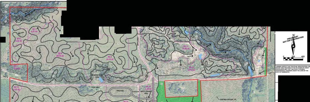
7 O:\17000 Projects\ \ Renville County MN\17062 GIS\MAPDOCS\EAW\17062 igure 6 - Conceptual Site Plan Map-Portrait.mxd Stre am Technical Single-Track Trails Channel Rock Crawling Wetland Active Gravel Pit Area (future trail area) ATV Trails ATV-Class 1 & Single-Track Trails Beginner ATV Trails Picnic - Interpretation Area Wetland G UV164 C hann el Trailhead Trials & Technical ATV Trails Wetland C Safety Training Area Wetland A Beginner Trails Wetland B Open Riding Buffer Area Wetland E ATV-Class 1 & Single-Track Trails C h anne l Wetland D Wetla nd Are a Channel Project Area Road Types Dirt Roa d Gravel Road Buffer Area Open Riding Ma in ten ance /Em erge ncy Access Ro ute Preliminary OHV Trails Class 1 - Up to 50 " m iles Class 2 - Up to 65 " m iles 205th St UV165 OHM - Off-Highway Motorcycles miles OHV Experience Zones ATV ROV Trails ATV-Class 1 & Single -Tra ck Trails Beginner ATV & ROV Trails Beginner Trails Buffer Area Open Riding Picnic - Inte rpreta tion Area Rock Crawling Safety Training Area Technical Single-Track Trails Trailhea d Trials & Technical ATV Trails Source: Orthophotograph (USDA NAIP, 2015) Wetland Delineation (ISG, April 2016) inch = 700 feet e et Monday, January 16, 2017 igure 6 Conceptual Site Plan Map Sacred Heart Twp, Renville County, Minnesota


8 UV UV th St 984 Project Area 2' Contours 10' Contours 980 O:\17000 Projects\ \ Renville County MN\17062 GIS\MAPDOCS\EAW\17062 igure 7 - Aerial Photograph Map-Portrait.mxd Source: Orthophotograph (USDA, NAIP, 2015) 2 ft Contours (2010) eet 1 inch = 700 feet igure 7 Aerial Photograph and LiDAR Map Sacred Heart Twp, Renville County, Minnesota
9 L83A 1355B 27A 247 L201A L201A B A 1370B A A 1030 UV B A 39B A A 327B 770C2 875C 327C 327B 327C 1392B B 39A O:\17000 Projects\ \ Renville County MN\17062 GIS\MAPDOCS\EAW\17062 igure 8 - Soil Classification Map.mxd 327C 875C 463A W 1261B 327B 1388B 39A 39B 1845B 39B 39A C 94C 1845B 1270D 1261B B 463B 27A 1270D 1270D 39B B A 770C2 UV th St 327B B 1268 Project Area Prime armland All Areas are Prime armland armland of Statewide Importance Prime armland if Drained Prime armland if Protected rom looding Not Prime armland Existing Buildings Source(s): Orthophoto (USDA, NAIP, 2013) Soil Survey (USDA NRCS, 2015) eet 1 inch = 800 feet Thursday, ebruary 23, 2017 igure 8 Soil Classification Map Sacred Heart Twp, Renville Minnesota

10 IGURE 9
61 County Well Index Located County Well Index Unlocated St 210th 770th")
 58 565 19 148843 Harvest Ave CSAH PEM 1A PSS1A PEM 1C PEM 1 Boiling Spring Creek 15 209730 PUB PUBHh CSAH 12 PSS1B")
11 145th St PUBH R2UBH ")81 PUBh CSA H UV94 770th Ave 200th St Sacred Heart Creek Impaired or: E. Coli PEM 1Ah PO1Ax PEM 1Ch PABx PEM 1x Project Area UV94 1 mile Radius NWI MPCA Impaired Waters DNR Public Watercourse USGS ")61 County Well Index Located County Well Index Unlocated St 210th 770th Ave Sacred Heart Creek O:\17000 Projects\ \ Renville County MN\17062 GIS\MAPDOCS\EAW\17062 igure 10 - Surface Hydrology eatures Map.mxd PUBHx PEM 1Cx 430th St UV3 PAB PO1C UV2 410th St PSS1/EM1A 420th St T-8 UV8 ") Harvest Ave CSAH PEM 1A PSS1A PEM 1C PEM 1 Boiling Spring Creek PUB PUBHh CSAH 12 PSS1B PEM 1B PSS1C Minnesota River Impaired or: Mercury & PCB Minnesota River PUSAx UV100 Hunter Ave UV 164 PSS1/EM1B UV th St Echo Creek PUSCx PSS1Ax 760th Ave UV th St Echo Creek Echo Creek PO1B UV th St Ideal A ve PUBx UV259 T-278 UV Sacred Heart Creek PO1A PEM 1Af Im pala Ave UV 322 Minnesota River State Water Trail & Minnesota River Wild and Scenic River Echo Creek Impaired or: ishes Bioassessments 410th St Sacred Heart Creek, East Branch UV7 PN: Source(s): Orthophoto (USDA, NAIP, 2013) Impaired Waters (MPCA, 2012) ,250 2,500 ee t 1 inch = 2,500 feet Monday, January 16, 2017 igure 10 Surface Hydrology eatures Map Sacred Heart Twp, Renville, Minnesota

: Roads (MNDOT, 2012) 0 20 5 410 820 ee t 1")
12 UV164 Renville County O:\17000 Projects\ \ Renville County MN\17062 GIS\MAPDOCS\EAW\17062 igure 11 - Road Classification Map.mxd Minnesota River Valley Scenic Byway Redwood County 205th St UV165 Project Area Counties Roads Interstate US Highway State Highway County State Aid Highway County Road Local Roads Town sh ip Ro ad Source(s): Roads (MNDOT, 2012) ee t 1 inch = 800 feet Monday, January 16, 2017 igure 11 Road Classification Map Sacred Heart Twp, Renville County, Minnesota
13 Renville County, MN SACRED HEART SOUTH TOWNSHIP «9 180th St County Rd 81 «12 780th Ave 770th Ave 220th St 760th Ave Min neso ta Riv er «15 ZONING MAP April,2011 Zoning Districts Agricultural (A) Commercial / Industrial (CI) Rural Residential (RR) Shoreland Residential (SR) Shoreland Special Protection (SSP) Urban Expansion (UE) Incorporated Cities (IC) ( ÿ U.S. Highway State Highway C.S.A.H. County and Township Roads Municipal Rivers Drainage Ditches s IGURE Miles
Preliminary Site Evaluation
 Preliminary Site Evaluation 100 Acre Site, US 72 Piperton, Tennessee Power Distributor: Chickasaw Electric Cooperative August 2010 SITE DATA SHEET PIPERTON US 72 SITE (100 ACRES): LOCATION & GENERAL DESCRIPTION
Version Isolated & Non-Waters Only 1 of 3
 APPROVED JURISDICTIONAL DETERMINATION FORM U.S. Army Corps of Engineers SECTION I: BACKGROUND INFORMATION A. REPORT COMPLETION DATE FOR APPROVED JURISDICTIONAL DETERMINATION (JD): July 6, 2010. B. DISTRICT
F-2. Gentian Plant Survey. J:\scopes\04w018\10000\FVD reports\final EIA\r-EIA app.doc
 F-2 Gentian Plant Survey J:\scopes\04w0\10000\FVD reports\final EIA\r-EIA app.doc Narrow-leaved Gentian 1. Introduction Several Narrow-leaved Gentian NLG) plants were found along the Salmon Trout River
Road Scholar Gopher Science Olympiad Invitational January 6, Team #: Team Name: Names: Score:
 Road Scholar Gopher Science Olympiad Invitational January 6, 2018 Team #: Team Name: Names: Score: Welcome to Road Scholar! Your Science Olympiad team is planning a trip to an invitational tournament in
Table 1: Avocado Flats Communication Site. Latitude 1 Longitude 1 Elev 2 Address T/R/S 3 APN 4 USGS Quadrangle
 County of Riverside Public Safety Enterprise Communication Project Appendix A: Candidate Site Descriptions Overview The candidate area is located in Northern San Diego County, 0.65 mile south of the border
AMENDMENTS TO THE SHERBURNE COUNTY ZONING MAP
 LEGEND NE1/4 of SE1/4 20-33-27 & NW1/4 of SW1/4 21-33-27 71 acres 35N Rge 30 W 35N Rge 29W PALMER TOWNSHIP Big Lake Highway Corridor Study Area (Hwy 10 & 25) 34N Rge 29W and 30W CLEAR LAKE TOWNSHIP 35N
David Magney Environmental Consulting
 David Magney Environmental Consulting DELINEATION OF JURISDICTIONAL WATERS AND RIPARIAN HABITATS FOR LYONS CANYON RANCH, NEWHALL, CALIFORNIA Prepared for: UNITED STATES ARMY CORPS OF ENGINEERS and CALIFORNIA
FHWA P/N Guidelines. Corridor Relationship. Highway 22 Segment 1 - US 169 to CSAH 2 Relevance / Documentation of Need
 Highway 22 Segment 1 - US 169 to CSAH 2 Vehicle Mobility Congestion Intersection Congestion Existing Conditions - Based on Highway Capacity Manual methodology, corridor level of service is currently LOS
Airport Closure Evaluation Report Prepared by MnDOT Aeronautics
 Airport Closure Evaluation Report Prepared by MnDOT Aeronautics Impacts of Closing The Murdock Municipal Airport (23Y) Summary Impacts of Closing the Murdock Municipal Airport (23Y) Closing a publicly
Digital Terrain Analysis of Archer Mountain
 Digital Terrain Analysis of Archer Mountain Identifying a potential new recreational trail Photo: Justin Bush GEOG 593 - Duh Marcus Tobey Justin Bush Project Overview Background Project Area Overview Questions
Blue Ridge Recreation Area
 Concept Plan for Blue Ridge Recreation Area Clear Creek, CO April, 2017 Prepa red fo r: Prepared by: Published: April, 2017 Concept Plan Executive Summary The proposed Blue Ridge Recreation Area (Blue
We are pleased to present Stattelman Trust - Todd County ± Acres Bertha Township, Todd County
 We are pleased to present Stattelman Trust - Todd County 86.90 ± Acres Bertha Township, Todd County SUBJECT PROPERTY This property to be sold by Sealed Bid Auction Owner: Stattelman Trust; Thomas Stattelman,
F. Forest Recreation Management
 F. Forest Recreation Management F.1) Park and Recreation Management F.1.A. Program Overview. The park and recreation program has been in existence since 1980. With ever increasing outdoor recreation demands
Elevation. Plate 1 - Study Area Geomorphology. Glacial Deposition. Unit. 1-ft Contours. 1,000 Feet. batavia member carmi member haeger till member
 Plate 1 - Study Area Geomorphology Glacial Deposition Unit flowage basin batavia member carmi member haeger till member marshy valley wadsworth till member Streams & Flowage Paths Elevation /"% 1-ft Contours
Hydraulic Report. Trail 5 Snowmobile Trail Over Mulligan Creek. Prepared By: COLEMAN ENGINEERING COMPANY Karisa V. Falls, P.E.
 Prepared for: Prepared by: Marquette County Road Commission Coleman Engineering Company Marquette, Michigan Iron Mountain, MI December 2011 Hydraulic Report Trail 5 Snowmobile Trail Over Mulligan Creek
Cuyuna Connection and Cuyuna Hills Backcountry Trail PROPOSED TRAIL DEVELOPMENT December 21, Trail Suitability Analysis
 Cuyuna Connection and Cuyuna Hills Backcountry Trail PROPOSED TRAIL DEVELOPMENT December 21, 2017 Trail Suitability Analysis Trail Suitability Criteria: As set forth in the Crow Wing County Comprehensive
Fremont Point Cabin Reconstruction and Expansion Project Project Proposal & Public Scoping Documentation
 Fremont Point Cabin Reconstruction and Expansion Project Fremont-Winema National Forests Silver Lake Ranger District The Silver Lake Ranger District of the Fremont-Winema National Forests is proposing
Figure 1 shows the evaluation area around Tailings Basin Cells 2E/1E. Two areas were evaluated for potential wetland impacts including:
 Barr Engineering Company 4700 West 77th Street Minneapolis, MN 55435-4803 Phone: 952-832-2600 Fax: 952-832-2601 www.barr.com An EEO Employer Minneapolis, MN Hibbing, MN Duluth, MN Ann Arbor, MI Jefferson
COUNCIL REPORT Meeting Date: December 10, 2013
 Subject: Highway 63/881 Corridor Area Structure Plan Amendment Bylaw No. 13/037 APPROVALS: Felice Mazzoni, Director Henry Hunter, Executive Director Glen Laubenstein, Chief Administrative Officer COUNCIL
Property Address: 4844 LUM RD ATTICA MI Owner: LAPEER COUNTY TREASURER Taxpayer: DUNCAN EDWARD
 08/16/2017 FORECLOSURE LIST FOR LAPEER COUNTY 11:15 AM For 2017 Foreclosures of 2014 and prior taxes BY: WMM POPULATION: BLOCK, INDEX: FORCL. YEAR/PARCEL # Interest Computed As Of Foreclosure Date TAXNTEREST/FEES
Public Notice. Latitude: N Longitude: W 7.5 Minute Quad: KY-BURLINGTON
 Public Notice US Army Corps of Engineers Louisville District Public Notice No. Open Date: Close Date: 1 Dec 2014 31 Dec 2014 Please address all comments and inquiries to: U.S. Army Corps of Engineers,
ACTIVE DEVELOPMENT APPLICATIONS - AUGUST 2013
 ACTIVE DEVELOPMENT APPLICATIONS - AUGUST 2013 BOARD OF VARIANCE ST-01-08 Lot A, Section 110, Sooke District, VIP65208; 6019 East Sooke Road East Sooke Two dwelling building conversion strata ST-04-11 Lot
Proposed Project 1: Kimble Loop East Horse Trail Reroute (1). Horse Trail Reroute: March 14, 2012
. Horse Trail Reroute: March 14, 2012") Proposed Project 1: Kimble Loop East Horse Trail Reroute The Ironton District Ranger requests your comments on proposed trail project on National Forest System lands. (1). Horse Trail Reroute: The proposed
Proposed Project 1: Kimble Loop East Horse Trail Reroute The Ironton District Ranger requests your comments on proposed trail project on National Forest System lands. (1). Horse Trail Reroute: The proposed
Emily to Blind Lake Trail PROPOSED TRAIL DEVELOPMENT APPLICATION SUMMARY
 Emily to Blind Lake Trail PROPOSED TRAIL DEVELOPMENT APPLICATION SUMMARY Township 137 Range 26 (Fairfield Township) sections 2 & 3 Township 138 Range 26 (City of Emily) sections 27, 34, 35, & 36 Township
PUBLIC INFORMATION SESSION #2
 Highway 16, Highway 779 to Kapasiwin Road, Planning Study PUBLIC INFORMATION SESSION #2 Wednesday June 20, 2012 4 to 8 pm HIGHWAY 16 Highway 779 to Kapasiwin Road Functional Planning Study Blueberry Community
APPENDIX C RECREATION OPPORTUNITY SPECTRUM PROCESS AND CLASSES
 APPENDIX C RECREATION OPPORTUNITY SPECTRUM PROCESS AND CLASSES RECREATION OPPORTUNITY SPECTRUM PROCESS Recreation area management objectives are defined through a planning process referred to as the Recreation
2010 INVENTORY OF STATE-OWNED LAND
 Department: Minnesota Historical Society Contact: David Kelliher Phone: 651-259-3103 Email: David.kelliher@mnhs.org Total Acres: 587.41 Total Bldg. Sq. Ft. 380,009 This document is made available electronically
Minutes of the Town of Perinton Conservation Board Meeting of. January 15, 2008
 Minutes of the Town of Perinton Conservation Board Meeting of January 15, 2008 Present: Absent: Others Present: John Minichiello, Acting Chairman Chris Fredette Paul Bogart Dave Belaskas Mike Doser Jerry
SF1363 / HF 1061: Legacy Funding; Conference Agreement
 - Conference 1 Art 1 - Outdoor Heritage Fund 2 3 Prairies 4 WMA, SNA, & Prairie Bank Easement Acq. Phase III 5 Accelerated Prairie Restoration - Phase III 6 MN Buffers for Wildlife & Water 7 Northern Tallgrass
ACOE 404 Application Figure 1 Typical Ditch and Berm Sytem Cross Section. Mosaic Fertilizer, LLC
 Ditch and Berm Design Elements Range in Width - Feet 1. Silt fence 5-10 2. Berm outside slope (2H:1V max, 4H:1V slope, 4-10 ft. high) 8-40 3. Berm top road (drivable) 20-30 4. Berm inside slope (2H:1V
Wacouta Twp. Florence Twp. Lake City. Mount Pleasant Twp. Lake Twp. Chester Twp West Albany Twp Gillford Twp. Zumbro Falls. Hyde Park Twp.
 M I S S I S S I Vermillion Empire Twp Castle Rock Twp Sciota Twp 0 Randolph Vermillion Twp Sheet Map 1 Hampton Hampton Twp CO New Trier Sheet Map 2 Stanton Twp Sheet Map Randolph Twp Cannon Falls 20 Marshan
Knutson explained to Trost that Chad is being taxed on the use of his property.
 1 2 3 4 5 6 7 8 9 10 11 12 13 14 15 16 17 18 19 20 21 22 23 24 25 26 27 28 29 30 31 32 33 34 35 36 37 38 39 40 41 42 43 44 45 46 Becker County Planning Commission April 10 th, 2018 Members Present: Chairman
We are pleased to present Peter & Arlyss Dirkx Farm 120 ± Acres Sterling Township, Blue Earth County
 We are pleased to present Peter & Arlyss Dirkx Farm 120 ± Acres Sterling Township, Blue Earth County PARCEL 1 PARCEL 2 PARCEL 3 = PARCELS 1+2 This property to be sold by Sealed Bid Auction Owner: Arlyss
Beaverhead-Deerlodge National Forest Butte Ranger District
 United States Department of Agriculture Forest Service Beaverhead-Deerlodge National Forest 1820 Meadowlark Lane Butte, MT 59701 406 494-2147 File Code: 1950 Date: September 1, 2010 Dear Interested Party:
Project Summary 2009
 Project Summary 2009 SB-2009-MN-55360: Lady Slipper Scenic Byway Pedestrian Walkway State Submission Date not submitted Division Submission Date not submitted State Priority 0 This application must be
Iron Range OHV State Recreation Area
 This document is made available electronically by the Minnesota Legislative Reference Library as part of an ongoing digital archiving project. http://www.leg.state.mn.us/lrl/lrl.asp Iron Range OHV State
Legend. à à Glacier à à Ã. CRA Tenure Amendment Line CRA Tenure Amendment Area Land File Toby Creek Adventures Tenure Mapping 2016
 500000 550000 CRA Amendment Overview Map Map 1 of 15 5650000 5650000 2 3 Arrow 4 6 5 10 7 9 8 11 Whiteswan Getmapping, Aerogrid, IGN, Alpine 1:400,000 Kilometers 0 10 20 Document Path: P:\16.0002.00_Toby
Matthiessen State Park Dells Area Hike
 90 Easy Hikes Close to Home At the south end of the hike, you ll climb on top of a mound left over from a former coal-mining operation in the park. Not far from Goose Lake Prairie, the town of Morris hosts
BASE MAP Town of South Hero
 BAS MAP Map 1 KLR Allenholm Air Strip South Hero Cemetery HRO [!ï [ Folsom lementary School Rd Apple Campground & Marina Rd Camp Skyland Z/GIS/Projects/County/GrandIsle/SouthHero/TownPlan2015/Map1.mxd
Environment and Natural Resources Trust Fund (ENRTF) M.L ENRTF Work Plan (Main Document)
 M.L ENRTF Work Plan (Main Document)") Environment and Natural Resources Trust Fund (ENRTF) M.L. 2018 ENRTF Work Plan (Main Document) Today s Date: December 8, 2017 Date of Next Status Update Report: January 31, 2019 Date of Work Plan Approval:
Environment and Natural Resources Trust Fund (ENRTF) M.L. 2018 ENRTF Work Plan (Main Document) Today s Date: December 8, 2017 Date of Next Status Update Report: January 31, 2019 Date of Work Plan Approval:
HYDROLOGY OF GLACIAL LAKES, FORT SISSETON AREA
 PROC. S.D. ACAD. SCI., VOL. 77 (1998) 59 HYDROLOGY OF GLACIAL LAKES, FORT SISSETON AREA Perry H. Rahn Department of Geology & Geological Engineering South Dakota School of Mines and Technology Rapid City,
NEW WEB TOOL FOR UNDERSTANDING BIOLUMINESCENT BAYS
 NEW WEB TOOL FOR UNDERSTANDING BIOLUMINESCENT BAYS Fernando Gilbes Santaella* and William Hernandez GERS Lab-Department of Geology University of Puerto Rico at Mayaguez *fgilbes@uprm.edu RESEARCH COMPONENT
Bratt ") 4. % F l o r i d a D e s i g n a t e d P a d d l i n g T r a i l s ") 164 «97 ") 99. Barrineau Park. M a p 1. M a p 2.
 4. % F l o r i d a D e s i g n a t e d P a d d l i n g T r a i l s ) 164 «97 ) 99. Barrineau Park. M a p 1. M a p 2.") F l o r i d a D e s i g n a t e d P a d d l i n g T r a i l s Bratt ") 4 Bluff Springs «4 Jay ") P e r d i d o R i v e r P e r d i d o CR R99A i v Walnut e r Hill ") 164 ") 97A «89 «97 ") 197 Barrineau
F l o r i d a D e s i g n a t e d P a d d l i n g T r a i l s Bratt ") 4 Bluff Springs «4 Jay ") P e r d i d o R i v e r P e r d i d o CR R99A i v Walnut e r Hill ") 164 ") 97A «89 «97 ") 197 Barrineau
Environment and Natural Resources Trust Fund (ENRTF) M.L Work Plan
 M.L Work Plan") Environment and Natural Resources Trust Fund (ENRTF) M.L. 2014 Work Plan Date of Report: 28 May, 2014 Date of Next Status Update Report: 15 January, 2015 Date of Work Plan Approval: Project Completion
Environment and Natural Resources Trust Fund (ENRTF) M.L. 2014 Work Plan Date of Report: 28 May, 2014 Date of Next Status Update Report: 15 January, 2015 Date of Work Plan Approval: Project Completion
We are pleased to present Cummiskey Farm 80 ± Acres Farmland & Hunting/Rec. Kilkenny Township, Le Sueur County
 We are pleased to present Cummiskey Farm 80 ± Acres Farmland & Hunting/Rec. Kilkenny Township, Le Sueur County SUBJECT PROPERTY View drone video at www.wingertrealty.com This property to be sold by Sealed
OFFICE OF THE PLANNING COMMISSION City Hall Holland, Michigan
 OFFICE OF THE PLANNING COMMISSION City Hall Holland, Michigan Planning Commission Report Report 4 To: Mayor DeBoer and Members of the Holland City Council Date: May 25, 2016 Subject: 11th Street Rezoning
Auburn Trail / Ontario Pathways Trail Connector Feasibility Study Public Information Meeting Wednesday, August 22, 2012
 Auburn Trail / Ontario Pathways Trail Connector Feasibility Study Public Information Meeting Wednesday, August 22, 2012 Purpose of Feasibility Study Purpose Evaluate the feasibility of constructing a multiuse
LAKE SURVEY REPORT DRAFT VERSION PRELIMINARY DATA (AS OF 07/24/2018) Fisheries Management. DOW Number: Survey ID Date: 07/16/2018
 Fisheries Management. DOW Number: Survey ID Date: 07/16/2018") Fisheries Management LAKE SURVEY REPORT DRAFT VERSION PRELIMINARY DATA (AS OF 7/2/2) Lake Name: Long Survey Type: Standard Survey DOW Number: 3-- Survey ID Date: 7/6/2 Lake Identification Alternate Lake
Fisheries Management LAKE SURVEY REPORT DRAFT VERSION PRELIMINARY DATA (AS OF 7/2/2) Lake Name: Long Survey Type: Standard Survey DOW Number: 3-- Survey ID Date: 7/6/2 Lake Identification Alternate Lake
UAV Flight Services Company. What We Do. What Sets us Apart
 UAV Flight Services Company A dedicated team of aviators, technologists, and engineers. What We Do UAV flight services for data collection, mapping, and inspection What Sets us Apart Extensive field experience,
Steer Creek Campground Corral
 Steer Creek Campground Corral Purpose and Need The purpose of this project is to increase the availability of camping experiences and services for equestrians at the Steer Creek Campground in the Samuel
Table 1: Black Eagle Communication Site. Latitude 1 Longitude 1 Elev 2 Address T/R/S 3 APN 4 USGS Quadrangle
 County of Riverside Public Safety Enterprise Communication Project Appendix A: Candidate Site Descriptions Overview The site is located on a previously graded and benched plateau within the Black Eagle
Group similar facilities together separate dissimilar facilities.
 Park design Principle #1 Group similar facilities together separate dissimilar facilities. Why do we do this? Safety Differences in admission fees Differences in seasonal use Reduce user conflicts Principle
STRATHCONA COUNTY YELLOWHEAD NORTH ARTERIAL ROAD FUNCTIONAL DESIGN STUDY
 STRATHCONA COUNTY Appendix G - Right-of-Way Plans ( TR) TC +65.7 POB +. YELLOW HEAD NORTH 376 MC PIPELINE CORRIDOR.56 HECTARES.7 HECTARES. HECTARES.3 HECTARES LOT B A. TOWNSHIP ROAD 53 JOB RANGE ROAD 3
St. Croix Savanna SNA
 N44 59.954 W92 46.946 N44 59.906 Na ve Plant Communi es* Dry Sand - Gravel Oak Savanna (Southern) * Source: Minnesota Biological Survey N44 59.673 W92 46.734 N44 59.754 W92 46.748 National Wetlands Inventory
STATE OF MINNESOTA DEPARTMENT OF NATURAL RESOURCES
 STATE OF MINNESOTA DEPARTMENT OF NATURAL RESOURCES Pursuant to Minnesota Statutes, Section 105.391, Subd. 1, the Commissioner of Natural Resources hereby publishes the final inventory of Protected (i.e.
ACTIVE DEVELOPMENT APPLICATIONS - FEBRURAY 2015
 ACTIVE DEVELOPMENT APPLICATIONS - FEBRURAY 2015 AGRICULTURAL LAND RESERVE - SUBDIVISION ALR-01-13 That Part of Section 34, Otter District, Shown Outlined in Red on Plan Deposited Under Otter Point Two
National Recreation Trail Application for Designation
 National Recreation Trail Application for Designation Introduction Thank you for your interest in the National Recreation Trail (NRT) program. Completed NRT application packages must be submitted by December
Appendix A Appendix A (Project Specifications) Auk Auk / Black Diamond (Trail 44) Reroute
 Auk Auk / Black Diamond (Trail 44) Reroute") Appendix A (Project Specifications) Auk Auk / Black Diamond (Trail 44) Reroute I. Proposed Action: This project proposes to reroute approximately 1,800 feet of a 50 inch wide trail, off of private property
Appendix A (Project Specifications) Auk Auk / Black Diamond (Trail 44) Reroute I. Proposed Action: This project proposes to reroute approximately 1,800 feet of a 50 inch wide trail, off of private property
COUNTY TRAIL SYSTEM DESIGN: RENVILLE COUNTY
 COUNTY TRAIL SYSTEM DESIGN: RENVILLE COUNTY JUNE 2010 ACKNOWLEDGEMENTS This project was produced and completed by The Center for Changing Landscapes, College of Design, College of Food, Agricultural, and
WELCOME. PUBLIC WORKSHOP #3 Fredericksburg Relief Route Study
 WELCOME PUBLIC WORKSHOP #3 Fredericksburg Relief Route Study Sign in so we can keep you updated on the study. View the information boards in the Sanctuary and take a seat. A presentation will begin at
National Recreation Trail Update Form
 National Recreation Trail Update Form Introduction Thank you for taking the time to complete this form. Your assistance will help ensure that the National Recreation Trail (NRT) database is complete and
AND PERMITTEE DATE LOCATION OF WORK
 04 Aug 2003 Regulatory Branch PUBLIC NOTICE ------------- 1. Pursuant to Code of Federal Regulations 33 CFR 325.2(a)(8), the Chicago District issued permits or other approvals, withdrawals, appeals or
Table 1: Paradise Communication Site. Latitude 1 Longitude 1 Elev 2 Address T/R/S 3 APN 4 USGS Quadrangle
 County of Riverside Public Safety Enterprise Communication Project Appendix A: Candidate Site Descriptions Overview The site is located atop a west-facing ridge overlooking the City of Norco, approximately
DOW Number: Survey ID Date: 08/21/2018. Windom Southern
 Fisheries Management DRAFT VERSION PRELIMINARY DATA (AS OF /4/) Lake Name: Hall Survey Type: Standard Survey DOW Number: 4-- Survey ID Date: // Lake Identification Alternate Lake Name: Primary Lake Class
County of Riverside - PSEC Project General Habitat Assessment Appendix A
 County of Riverside - PSEC Project General Habitat Assessment Appendix A Lake Elsinore Lake Elsinore The Lake Elsinore study area is located in the hills directly adjacent to Lake Elsinore, in the City
DRAFT GENERAL IMPLEMENTATION PLAN AND SPECIFIC IMPLEMENTATION PLAN MIDDLETON MUNICIPAL AIRPORT MOREY FIELD. Revised 12/12/03
 DRAFT GENERAL IMPLEMENTATION PLAN AND SPECIFIC IMPLEMENTATION PLAN MIDDLETON MUNICIPAL AIRPORT MOREY FIELD Revised 12/12/03 As recommended for approval by the Plan Commission General Project Description
Waukegan & Calumet Rivers. All Hands Meeting
 Waukegan & Calumet Rivers 516(e) Update All Hands Meeting David F. Bucaro, P.E. Chief, Economic Formulation & Analysis Section, Planning Branch May 18 th, 2011 Kensington Court Ann Arbor, MI 1 2 Waukegan
DISTRICT COURT, WATER DIV. 6, COLORADO TO ALL PERSONS INTERESTED IN WATER APPLICATIONS IN WATER DIV. 6
 DISTRICT COURT, WATER DIV. 6, COLORADO TO ALL PERSONS INTERESTED IN WATER APPLICATIONS IN WATER DIV. 6 Pursuant to C.R.S. 37-92-302, you are hereby notified that the following pages comprise a resume of
Minnesota Department of Natural Resources
 Minnesota Department of Natural Resources Fisheries Management DRAFT VERSION - PRELIMINARY DATA (AS OF 6/2/2) Lake Name: Yankton Survey Type: Population Assessment DOW Number: 2-7- Survey ID Date: 6/6/2
Minnesota Department of Natural Resources
 Minnesota Department of Natural Resources Fisheries Management LAKE SURVEY REPORT DRAFT VERSION - PRELIMINARY DATA (AS OF 7//26) Lake Name: Loon Survey Type: Standard Survey DOW Number: 32-2- Survey ID
Minnesota Department of Natural Resources
 Minnesota Department of Natural Resources Fisheries Management VERSION - PRELIMINARY DATA (AS OF 7/6/25) Lake Name: Imogene Survey Type: Standard Survey DOW Number: 46-2- Survey ID Date: 7/3/25 Lake Identification
Segment 2: La Crescent to Miller s Corner
 goal of the USFWS refuges is to conserve, protect and enhance fish, wildlife and plants and their habitats for the continuing benefit of the American people. Refuge lands are used largely for fishing,
Forest Classification & Route Designation Plan or State Forest Lands Located in East-Central Minnesota
 Forest Classification & Route Designation Plan or State Forest Lands Located in East-Central Minnesota Response to Comments November 4, 2008 Minnesota Department of Natural Resources East-Central Minnesota
Minnesota Department of Natural Resources
 Minnesota Department of Natural Resources Fisheries Management LAKE SURVEY REPORT DRAFT VERSION - PRELIMINARY DATA (AS OF /4/2) Lake Name: Talcot Survey Type: Standard Survey DOW Number: -- Survey ID Date:
BA Collaborators. Driftless Area Initiative The Prairie Enthusiasts Trout Unlimited TNC TCF Natural Resources Foundation of Wisconsin
 BA Collaborators Driftless Area Initiative The Prairie Enthusiasts Trout Unlimited TNC TCF Natural Resources Foundation of Wisconsin The mission of the of the Blufflands Alliance is to actively conserve
H. R IN THE HOUSE OF REPRESENTATIVES
 I 113TH CONGRESS 1ST SESSION H. R. 1776 To establish the Clear Creek National Recreation Area in San Benito and Fresno Counties, to designate the Joaquin Rocks Wilderness in such counties, to designate
MINUTES. Additional Stakeholders including CU, CDOT, Town of Erie, and Weld County have been contacted and invited to the recurring progress meetings.
 PROGRESS MEETING BOULDER CREEK MASTER PLAN UDFCD, BOULDER COUNTY, CITIES OF BOULDER & LONGMONT JANUARY 13, 2015 AT 1:00 PM MINUTES 1) ATTENDEES Craig Jacobson, ICON Engineering, Inc. Brian LeDoux, ICON
Public Notice ISSUED: December 10, 2018 EXPIRES: January 9, 2019
 APPLICANT: REFER TO: St. Louis and Lake Counties Regional Rail Authority 2018-01942-ARC Public Notice ISSUED: December 10, 2018 EXPIRES: January 9, 2019 SECTION:404 - Clean Water Act 1. APPLICATION FOR
A G E N D A MEETING CITY COUNCIL THIRD FLOOR ANNEX CHAMBERS. TUESDAY, September 27, :45 PM
 A G E N D A MEETING CITY COUNCIL THIRD FLOOR ANNEX CHAMBERS TUESDAY, Septeber 27, 2016 5:45 PM Pledge of Allegiance Moent of Silence Roll Call Minutes Mayor s Report/City Council Sub-Coittee Reports City
STORY MILL COMMUNITY PARK
 OWNER: City of Bozeman Department or Parks and Recreation P.O. Box 1230, 415 N. Bozeman Street Bozeman, MT 59715 Tel: (406)-582-2908 APPLICANT: The Trust for Public Land 1007 E. Main Street, Suite 300
3.0 EXISTING PARK & RECREATION SPACE
 3.0 EXISTING PARK & RECREATION SPACE TOWN PARK & RECREATION SPACE An inventory of current parks and recreation area in the Town of Cedarburg is shown in Table 3. These areas total roughly 381.89 acres.
Washington County Ostrum Trail North/Broadway Street (CSAH 4)
") Washington County Ostrum Trail North/Broadway Street (CSAH 4) Open House Agenda Introductions Project Presentation Group Questions & Answers Breakout Sessions by Zones Discuss project details, issues,
Washington County Ostrum Trail North/Broadway Street (CSAH 4) Open House Agenda Introductions Project Presentation Group Questions & Answers Breakout Sessions by Zones Discuss project details, issues,
Access to the site is obtainable from the paved driveway leading to the MWD facility.
 County of Riverside Public Safety Enterprise Communication Project Appendix A: Candidate Site Descriptions Overview The site is located adjacent to a Metropolitan Water District (MWD) facility on El Sobrante
NEW MULTI -TENANT BUILDING
 NEW MULTI -TENANT BUILDING INTERSTATE 94 Waukegan High School 4,375 Students 2.15 Miles 23,0 Warren Township High School 2,250 Students 1.75 Miles Vista Memorial Hospital 2,0 Employees 1.77 Miles WASHINGTON
DAKOTA CULTURE UPPER SIOUX COMMUNITY: AREA CHARACTER ANALYSIS ALIGNMENT STRATEGY
 UPPER SIOUX COMMUNITY: AREA CHARACTER ANALYSIS ALIGNMENT STRATEGY 51 AREA CHARACTER ANALYSIS: OPPORTUNITIES & CONSTRAINTS RECREATIONAL VEHICLE PARK: A recreational vehicle park will be built to accommodate
ATVANS Trail Assessment for Five Bridge Lakes Wilderness Area Report and Recommendation. December 28, Prepared by.
 ATVANS Trail Assessment for Five Bridge Lakes Wilderness Area Report and Recommendation December 28, 2011 Prepared by Peter Bush Background This report documents the results and recommendations of an all-terrain
APPENDIX F List of Commitments
 APPENDIX F List of Commitments s Table F.1 Standard Mitigation Measures Mitigation Measure MnDOT Specification Number Status Update Description Status Update Utilities Provide early notice to utility operators
Table 1: Margarita (SDSU) Communication Site. Latitude 1 Longitude 1 Elev 2 Address T/R/S 3 APN 4 USGS Quadrangle
 Communication Site. Latitude 1 Longitude 1 Elev 2 Address T/R/S 3 APN 4 USGS Quadrangle") County of Riverside Public Safety Enterprise Communication Project Appendix A: Candidate Site Descriptions Margarita (SDSU) Communication Site Margarita (SDSU) Communication Site Overview The site is located
County of Riverside Public Safety Enterprise Communication Project Appendix A: Candidate Site Descriptions Margarita (SDSU) Communication Site Margarita (SDSU) Communication Site Overview The site is located
3. Trail Alignment. Overview. Criteria for Location of the Trail
 3. Trail Alignment Overview The Houston to La Crescent Extension of the Root River Trail is part of the legislatively authorized Blufflands State Trail System. The entire trail segment is approximately
MICHIGAN DEPARTMENT OF NATURAL RESOURCES FOREST MANAGEMENT DIVISION COMMERCIAL FOREST PROGRAM - HUNTER LIST
 MICHIGAN DEPARTMENT OF NATURAL RESOURCES FOREST MANAGEMENT DIVISION COMMERCIAL FOREST PROGRAM - HUNTER LIST Lands listed as of 03/16/2017 MISSAUKEE County Location: BLOOMFIELD-24N-08W-14 Legal: Legal:
New Orleans Saints vs Minnesota Vikings October 27 29, 2018 Sat Mon
 New Orleans Saints vs Minnesota Vikings October 7 9, 018 Sat Mon PACKAGE INCLUDES: Motor coach transportation from Brandon, Portage La Prairie and Winnipeg. night s hotel in Minneapolis at the Hilton Garden
Riverbend on the St. Johns River DeBa ry, Fl o r i d a March 03,
 Copyright 2008. All Rights Reserved. Looney Ricks Kiss Architects, Inc. Canoe/torage uilding Third Entrance Main or econdary Entrance Possible 10 oat Trailer Parking Location Possible oat Ramp Location
Mountain Valley Pipeline Project. Docket No. CP
 Supplemental Responses to FERC Staff s Recommended Mitigation in Draft Environmental Impact Statement December 2016 14. Prior to the end of the draft EIS comment period, Mountain Valley shall file with
Roduner Ranch FOR SALE. 5,878± Acres Potential Development Land. Merced County, California. Offices Serving The Central Valley
 FOR SALE 5,878± Acres Potential Development Land Merced County, California Offices Serving The Central Valley F R E S N O V I S A L I A B A K E R S F I E L D 7480 N. Palm Ave, Ste 101 3447 S. Demaree Street
Promenade Boulevard. Shoulder South Brunswick Twp, Middlesex Co Secondary Direction STOUTS LN (0.13) Road Overpass
 Road Overpass") Mile Posts: 0.000 -.000 ROUTE 5 (West to East) Promenade Boulevard He rb e rt Highway Richard Kingsland Cir Princeton Gate Boulevard Rock y Hill Ess ex Driv e New Herbert Highway Old R idge Ri d ge 7976
Mile Posts: 0.000 -.000 ROUTE 5 (West to East) Promenade Boulevard He rb e rt Highway Richard Kingsland Cir Princeton Gate Boulevard Rock y Hill Ess ex Driv e New Herbert Highway Old R idge Ri d ge 7976
SAN MATEO COUNTY AGRITOURISM GUIDELINES
 SAN MATEO COUNTY AGRITOURISM GUIDELINES The San Mateo County Planning and Building Department and the San Mateo County Agricultural Advisory Committee s subcommittee on agritourism have developed the following
2. STAKEHOLDER FEEDBACK // What We Heard
 1. QUARRY ROAD TRAIL // Welcome to the Information Session PROJECT DESCRIPTION WHY WE ARE HERE Quarry Road Trail is a popular commuter trail and recreational area for Calgarians. 1. To report citizen feedback
SDTrucksprings. Indiana Off-roading/4x4 Guide Copyright 2015 We Specialize In:
 SDTrucksprings Indiana Off-roading/4x4 Guide Copyright 2015 We Specialize In: Helper Springs Air Bags Leaf Springs Body Lift Kits Coil Springs Timbren Kits Hellwig Springs Lift Blocks And More! Visit www.sdtrucksprings.com
Topo Map Explorer. Adapted from: An original Creek Connections activity. Creek Connections, Box E, Allegheny College, Meadville, Pennsylvania, 16335
 Topo Map Explorer Adapted from: An original Creek Connections activity. Creek Connections, Box E, Allegheny College, Meadville, Pennsylvania, 16335 Review of major topographic map concepts Grade Level:
GILBERT & WEST TOWN INTERCOUNTY DRAIN Windsor Township, Eaton County and City of Lansing, Delhi Township, Ingham County, Michigan
 GILBERT & WEST TOWN INTERCOUNTY DRAIN Windsor Township, Eaton County and City of Lansing, Delhi Township, Ingham County, Michigan PRELIMINARY ENGINEERING REPORT Abigail Eaton, Chair Intercounty Drains