Development of Campsite Monitoring Protocols in Kenai Fjords
|
|
|
- Julie Mills
- 5 years ago
- Views:
Transcription


1 Utah State University From the SelectedWorks of Christopher Monz January 1, 2011 Development of Campsite Monitoring Protocols in Kenai Fjords F. Klasner Christopher Monz, Utah State University J. Cusick Available at:

2 32
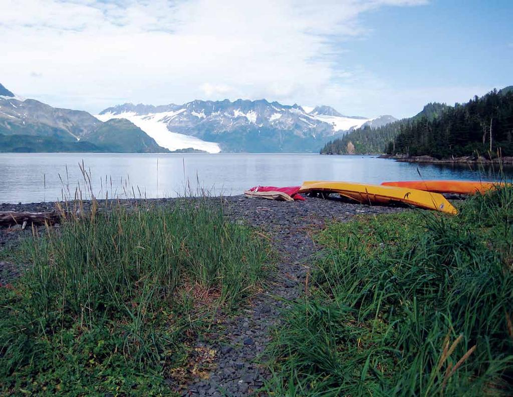
3 Alaska Park Science, Volume 10, Issue 1 Development of Campsite Monitoring Protocols in Kenai Fjords National Park By Fritz Klasner, Christopher Monz, and Joel Cusick The coastal campsite experience A night on the coast; it comes with spectacular waterfront views, peace and quiet, and fresh air. Camping on the Kenai Fjords National Park (NP) coast is an amazing experience that draws hundreds of visitors to the park each summer. Although the park is comprised of over 500 miles of spectacular coastline, most of the coast is characterized by steep, rocky headlands, cliffs, and boulder beaches that are virtually inaccessible to boaters and campers. As a result, opportunities for camping are limited to only about 80 sheltered sand/gravel beaches scattered along the length of the park from Nuka Bay in the southwest to Resurrection Bay in the northeast (Figure 2). About half of these potential campsites are located in the more remote southern end of the park, the outer coast, and Nuka Bay, and consequently receive very little overnight use. As a result, nearly all backcountry camping is concentrated at about 40 beaches located in Aialik Bay and Northwestern Lagoon. These same areas also contain sensitive cultural, archeological, and natural resources, including Figure 1. Kayaks on the beach at Kenai Fjords National Park, where kayaking is one of the primary modes of transportation for visitors traveling between campsites. Figure 2. Map of landing beaches surveyed during a 2007 rapid assessment. Visitor (campsite) impacts are concentrated in Northwestern Fjord and Aialik Bay. Rapid assessment results are used to inform multiple management concerns, from campsite impacts to invasive species and marine debris accumulations. salmon spawning streams, ground-nesting marine birds, coastal sedge meadows and, bald eagle nests. Management need Kenai Fjords has a history of periodic campsite surveys that dates to at least 1988 (Tetreau 2004). This work revealed impacts to park resources such as fire rings, charred wood, cut stumps, root exposure, vegetation trampling, trash, human waste, soil erosion, campsite proliferation, increased human-wildlife interactions, and social trails. Trends of increasing resource impacts raised concerns of altered ecologic condition, impacts to visitors wilderness experience, and for visitor safety (Figure 3). From 1988 to 2004 various monitoring methods were used to document conditions, and a review highlighted the need to improve the consistency, accuracy, and efficiency of field assessment and data analysis (Tetreau 2004, Monz et al. 2006). Former Kenai Fjords NP ecologist Meg Hahr turned the recommendations of Tetreau (2004) and Monz et al. (2006) into a collaborative effort that integrates science, mapping technologies, management, and visitor perspectives to inform and provide adaptive recommendations to park managers. Needed management information included details about condition of landing beaches, trends in visitor (camping) impacts at known campsites, size and number of tent sites, use and condition of bearresistant food storage lockers, and other visitor impacts. Since the park does not require permits for camping or most other forms of visitor use, managers needed a clear understanding of changes in the spatial distribution of preferred camping locations in a landscape where tidewater glaciers can retreat at rates approaching 246 feet (75 m) per year (Giffen et al. 2009), vegetation succession is equally as rapid, and shoreline or beach morphology changes are poorly understood due to the interaction of tectonic forces with sea level rise (Pendleton et al. 2006). In 2007, Hahr led a rapid assessment of campsite impacts at 55 landing beaches between Nuka and Aialik Bays (Figure 2). From 2008 to 2010, Dr. Christopher Monz, a recreation ecologist from Utah State University, spent several weeks in the park testing, refining, and implementing campsite monitoring protocols. During this same time NPS Alaska Regional Office Geographic Information System (GIS) staff were enlisted to develop Geographic Positioning System (GPS) data collection tools, protocols, and databases for managing the collected data in a streamlined manner (Figure 4). Park staff involvement included resource, visitor and resource protection specialists to ensure diverse management perspectives. Science Backcountry camping has the potential to affect resource conditions both intensively at the on-site scale and extensively due to site expansion and proliferation (Leung and Marion 1999, Cole 2004). Campsites are important from a managerial and visitor perspective as they serve as destinations and focal points for visitor activities, thereby creating areas of concentrated use. Although numerous studies of campsites in parks and protected areas have examined the degree to which visitor use can affect change on site conditions (e.g., Frissell 1978, Cole 1983, Marion 1995), studies examining change over long periods are few (e.g., Cole et al. 2008, Twardock et al. 2010). Campsite assessment methodologies have a long 33


.")
4 Development of Campsite Monitoring Protocols in Kenai Fjords National Park Figure 3. Campsites, such as these at Pedersen Lagoon, include impacts from tents, trails, cooking areas, as well as beach activities. Figure 4. A campsite monitoring team discussing methods at a training session. Figure 5. Alaska Regional Office database programmer Greg Daniels collects GPS data and records campsite attributes in the field. Photograph watermarks embed site and date information, helping ensure collected information is retained and accessible. 34 history of use in parks and protected areas, dating back to the work of Sumner (1942) and Frissell and Duncan (1965), to the more recent contributions of Cole (1989), Marion (1995) and Newman et al. (2006). While campsite studies are commonplace in the lower 48 states, relatively little work has been accomplished in Alaska environments with the exception of long-term studies conducted in Prince William Sound (Twardock et al. 2010, Monz and Twardock 2010). Lake Clark National Park and Preserve has maintained backcountry campsite inventories as early as the 1980s, but protocols and quantitative measurements have not been standardized. Based on reviews of the historical campsite work in Kenai Fjords NP and consultation with park staff, the development of new assessment protocols was initiated with four overall goals. First, the protocols needed to be more clear in definition of terms and descriptions of ratings-based procedures. Second, campsites needed established reference points that could easily be relocated. Relocation of sites had been problematic by the lack of established reference points and consequently site area remeasurement was not possible. Third, efficiently planning field work needed to be addressed in terms of staff time during an assessment trip and integrating program work into park operations. Last, protocols must withstand a changing field staff without sacrificing accuracy and repeatability. We were able to accommodate these concerns in several ways. We relied on contemporary campsite protocols developed in intervening years (e.g., Marion 1995) and on the extensive work conducted in Prince William Sound (Twardock et al. 2010) to make wholesale revisions to the methods. Improvements occurred to condition class ratings criteria and definitions, use of radial transect methods for termination of site areas, and to ratings-based systems for visual estimation of various impacts. Next, we conducted two extensive assessments with a large team that brought researchers, field staff and resource mangers together in the field to refine and troubleshoot the methods. Last, we incorporated the best available camera and GPS technology to streamline and enforce consistency in data collection, site relocation, and data processing. Technology The technological aspects of establishing protocols were daunting. We developed standardized, electronic data templates to ensure consistent data collection and integration with GPS data. Collection of photographic documentation, a critical component for comparisons with previous work, was also standardized, and its collection was integrated with GPS data (Figure 5). A geodatabase compatible with GIS was developed, serving as a shell to organize and manage this diverse information. One noteworthy benefit of integrating data collection into protocols is that multiple components of collected data are linked in GIS, in database applications, and in reporting tools. For example, electronic campsite maps coded by condition class and linked with site photographs are easily generated. Limited GPS reception in the steep-sided fjords of the park, wet conditions necessitating waterproof electronics, and the need for tools that can be used by staff with a range of technical knowledge were challenges encountered. Having the technical experts experience
5 Alaska Park Science, Volume 10, Issue 1 first-hand the field data collection and data management challenges proved essential to bridging these challenges. Applications of campsite assessments One of the opportunities that came with revising campsite monitoring methods has been to encourage park staff participation in monitoring efforts. The monitoring protocols provide a structure and clarity of purpose to field efforts, providing field staff with specific monitoring objectives integrated into other responsibilities while still allowing for opportunities to interact with visitors. Additional opportunities include invasive plant and coastal mortality (avian influenza and sea otters) surveys that can occur alongside campsite assessments. Direct improvements to campsite management were the intent of and are an outcome of this process. One example is the bear-resistant food storage lockers, which are one of the main tools the park has to promote or direct use to selected areas. The systematic visits and documentation of campsite and food storage lockers identified high visitor use areas with missing or substandard lockers. Since implementing updated campsite monitoring methods, Kenai Fjords National Park has been able to rapidly respond to changes in visitor use patterns, with data in hand to support management directed changes to campsite amenities. Acknowledgements This work would not have occurred without the tireless efforts of Meg Hahr (see dedication in this issue) and was made possible in part by grants from the National Park Service and National Park Foundation. We are also grateful for the support of NPS Alaska Region GIS Team member Greg Daniels for his efforts in developing GIS, GPS, and geodatabase tools. Kenai Fjords National Park staff Janette Chiron, Shelley Hall, and Christina Kriedeman and Utah State University doctoral student Kelly Goonan were instrumental in helping to start this monitoring. We would also like to thank the many field and office staff and crew for their assistance. REFERENCES Cole, D.N Monitoring the condition of wilderness campsites. USDA Forest Service Research Paper INT-302. Intermountain Forest and Range Experiment Station. Ogden, UT. Cole, D.N Wilderness campsite monitoring methods: A sourcebook. USDA Forest Service General Technical Report INT-259. Intermountain Research Station. Ogden, UT. Cole, D.N Impacts of hiking and camping on soils and vegetation. In Environmental Impacts of Ecotourism edited by R. Buckley. CABI. Wallingford, U.K. Pp Cole, D.N., P. Foti, and M. Brown Twenty years of change on campsites in the backcountry of Grand Canyon National Park. Environmental Management 41: Frissell, S.S Judging recreational impacts on wilderness campsites. Journal of Forestry 76: Frissell, S.S., and D.P. Duncan Campsite preference and deterioration in the Quetico-Superior canoe country. Journal of Forestry 65: Giffen, B.A., D.K. Hall, and J.Y.L. Chien Alaska: Glaciers of Kenai Fjords National Park and Katmai National Park and Preserve. In Global Land Ice Measurements from Space (GLIMS) Chapter 12. Draft report. Leung, Y.-F., and J.L. Marion Characterizing backcountry camping impacts in Great Smokey Mountains National Park, USA. Journal of Environmental Management 57: Marion, J.L Capabilities and management utility of recreation impact monitoring programs. Environmental Management 19: Monz, C.A, I. Martin, M. Tetreau, and S. Hall Visitor Use and Impact Monitoring in Kenai Fjords National Park: A summary of scoping results and future monitoring needs. Kenai Fjords National Park, Alaska. NPS Unpublished Report. Monz, C.A., and P. Twardock A classification of campsites in Prince William Sound, Alaska, USA. Journal of Environmental Management 91 (7): Newman, P.N., C.A. Monz, Y.-F. Leung, and D.M. Theobold New methodological considerations for assessing campsite conditions. George Wright Forum 23 (2): Pendleton, E.A., E.R. Thieler, and S.J. Williams Relative Coastal Change-Potential Assessment of Kenai Fjords National Park. U.S. Geological Survey Open-File Report Sumner, E.L The biology of wilderness protection. Sierra Club Bulletin 27 (8): Tetreau, M Backcountry campsite surveys in Aialik Bay, Resurrection Bay and Northwestern Fjord - Kenai Fjords National Park, Alaska. NPS Unpublished Report. Twardock, P., C.A. Monz, M. Smith, and S. Colt Long-term changes in resource conditions on backcountry campsites in Prince William Sound, Alaska, USA. Northwest Science 84 (3):
Recreation Impact Monitoring Analysis and Protocol Development, Glacier Bay National Park
 Utah State University From the SelectedWorks of Christopher Monz May, 2015 Recreation Impact Monitoring Analysis and Protocol Development, Glacier Bay National Park K. C. Goonan Christopher Monz, Utah
A Relatively Nonrestrictive Approach to Reducing Campsite Impact
 SCIENCE and RESEARCH A Relatively Nonrestrictive Approach to Reducing Campsite Impact Caney Creek Wilderness, Arkansas BY DAVID N. COLE AND THOMAS E. FERGUSON Abstract: An excessive number of highly impacted
DECISION MEMO. Rawhide Trail #7073 Maintenance and Reconstruction
 Page 1 of 6 Background DECISION MEMO USDA Forest Service Jefferson Ranger District Jefferson County, Montana Rawhide Trail #7073 is located in the Elkhorn Mountain Range approximately 10 miles east of
MARBLE RIVER PROVINCIAL PARK
 MARBLE RIVER PROVINCIAL PARK PURPOSE STATEMENT AND ZONING PLAN March 2003 MARBLE RIVER PROVINCIAL PARK Purpose Statement and Zoning Plan Primary Role The primary role of Marble River Park is to protect
Wilderness Research. in Alaska s National Parks. Scientists: Heading to the Alaska Wilderness? Introduction
 Wilderness Research in Alaska s National Parks National Park Service U.S. Department of Interior Scientists: Heading to the Alaska Wilderness? Archeologist conducts fieldwork in Gates of the Arctic National
Keeping Wilderness Wild: Increasing Effectiveness With Limited Resources
 Keeping Wilderness Wild: Increasing Effectiveness With Limited Resources Linda Merigliano Bryan Smith Abstract Wilderness managers are forced to make increasingly difficult decisions about where to focus
Appalachian Trail Sustainability Research Study
 Appalachian Trail Sustainability Research Study Appalachian National Scenic Trail 2,175 mile footpath from Maine to Georgia Crosses 14 states, 6 NPS units, and 8 National Forests, Managed by the NPS A.T.
Connie Rudd Superintendent, Black Canyon of the Gunnison National Park
 National Park Service U.S. Department of the Interior Black Canyon of the Gunnison National Park and Curecanti National Recreation Area Information Brochure #1 Wilderness and Backcountry Management Plan
Proposed Action Kaibab Campground Capital Improvement Project September 2008
 Background Kaibab Campground Capital Improvement Project September 2008 The Williams Ranger District of the Kaibab National Forest is proposing to improve the Kaibab Lake Campground. Kaibab Lake Campground
The role of recreation demand and supply information in monitoring outdoor recreation sustainability. Joel Erkkonen and Liisa Kajala
 The role of recreation demand and supply information in monitoring outdoor recreation sustainability Joel Erkkonen and Liisa Kajala Abstract Metsähallitus bears major responsibility for the development
SeagrassNet Monitoring in Great Bay, New Hampshire, 2016
 University of New Hampshire University of New Hampshire Scholars' Repository PREP Reports & Publications Institute for the Study of Earth, Oceans, and Space (EOS) 9-28-2017 SeagrassNet Monitoring in Great
PURPOSE AND NEED. Introduction
 Public Scoping: Allocation of Recreation Capacity for Commercial Outfitter Guide Services on North Kruzof Island Trails (Kruzof Island Outfitter Guide) PURPOSE AND NEED Introduction The U.S. Department
WILDERNESS AS A PLACE: HUMAN DIMENSIONS OF THE WILDERNESS EXPERIENCE
 WILDERNESS AS A PLACE: HUMAN DIMENSIONS OF THE WILDERNESS EXPERIENCE Chad P. Dawson State University of New York College of Environmental Science and Forestry Syracuse, NY 13210 Abstract. Understanding
Request for Proposal National Tropical Botanical Garden Lower Limahuli Preserve Emergency Stream Debris Removal
 Request for Proposal National Tropical Botanical Garden Lower Limahuli Preserve Emergency Stream Debris Removal I. Summary of Work Bids are solicited for the emergency removal of debris deposited in the
Federal Outdoor Recreation Trends Effects on Economic Opportunities
 United States Department of Agriculture Federal Outdoor Recreation Trends Effects on Economic Opportunities The Forest Service National Center for Natural Resources Economic Research is assisting the Federal
MAIN LAKE PROVINCIAL PARK
 MAIN LAKE PROVINCIAL PARK PURPOSE STATEMENT AND ZONING PLAN March 2003 MAIN LAKE PROVINCIAL PARK Purpose Statement and Zoning Plan Primary Role The primary role of Main Lake Park is to protect a biologically
MANAGING AMERICA S WILDERNESS ENDURING RESOURCE
 PUB #l96 MANAGING AMERICA S ENDURING WILDERNESS RESOURCE Campsite Management and Monitoring in Wilderness Some Principles To Guide Wilderness Campsite Management David N. Cole EDITED BY: David W. Lime
Tracy A. Farrell Jeffrey L. Marion. Solitude at the Wilderness Campsite
 Camping Impact Management at Isle Royale National Park: An Evaluation of Visitor Activity Containment Policies From the Perspective of Social Conditions Tracy A. Farrell Jeffrey L. Marion Abstract A survey
MUNICIPALITY OF ANCHORAGE
 MUNICIPALITY OF ANCHORAGE ANCHORAGE PARKS & RECREATION Memorandum PRC 08-56 DATE: 5 August 2008 TO: FROM: SUBJECT: Parks & Recreation Commission Holly Spoth-Torres, Park Planner PRC 08-56 Far North Bicentennial
A GIS Analysis of Probable High Recreation Use Areas in Three Sisters Wilderness Deschutes and Willamette National Forests
 Lindsey Kiesz Geo 565 Term Project 3/15/2010 A GIS Analysis of Probable High Recreation Use Areas in Three Sisters Wilderness Deschutes and Willamette National Forests Introduction The Three Sisters Wilderness
VARGAS ISLAND PROVINCIAL PARK
 VARGAS ISLAND PROVINCIAL PARK PURPOSE STATEMENT AND ZONING PLAN February 2003 VARGAS ISLAND PROVINCIAL PARK Purpose Statement and Zoning Plan Primary Role The primary role of Vargas Island Park is to protect
Photopoint Monitoring in the Adirondack Alpine Zone
 Photopoint Monitoring in the Adirondack Alpine Zone Julia Goren (PI) and Seth Jones Adirondack High Peaks Summit Steward Program Adirondack Mountain Club summit@adk.org PO Box 867, Lake Placid, NY 12946
Sawtooth National Forest Fairfield Ranger District
 United States Department of Agriculture Forest Service Sawtooth National Forest Fairfield Ranger District P.O. Box 189 Fairfield, ID. 83327 208-764-3202 Fax: 208-764-3211 File Code: 1950/7700 Date: December
The Roots of Carrying Capacity
 1 Applying Carrying Capacity Concepts in Wilderness 1872 1964...shall be preserved for the use & enjoyment of the American people...in such manner as will leave them unimpaired for future generations...
DIRECTOR S ORDER #41: Wilderness Preservation and Management
 These are relevant sections about Wilderness Management Plans from National Park Service 2006 Management Policies, Director s Orders #41 and Reference Manual 41. National Park Service U.S. Department of
Applying Carrying Capacity Concepts in Wilderness
 Applying Carrying Capacity Concepts in Wilderness...shall be preserved for the use & enjoyment of the American people...in such manner as will leave them unimpaired for future generations... CSS 490 Professor
USDA Trails Strategy WRI: ENGLISH PEAK SURVEY. Theodore Mendoza San Diego State University June 6 th 2016 August 18 th Advisor: Sam Commarto
 WRI: ENGLISH PEAK SURVEY Theodore Mendoza San Diego State University June 6 th 2016 August 18 th 2016 Advisor: Sam Commarto Klamath National Forest Submitted: March 21, 2017 Table of Contents Acknowledgements
Wildlife Tour (10 Days)
") Multi-Sport Camping Adventures Small Groups (10 max) Great Guides Top of the line Equipment Excellent Meals Active Experiences Wildlife Tour (10 Days) For those with wildlife viewing as a primary objective
Multi-Sport Camping Adventures Small Groups (10 max) Great Guides Top of the line Equipment Excellent Meals Active Experiences Wildlife Tour (10 Days) For those with wildlife viewing as a primary objective
Final Environmental Impact Statement for the Merced Wild and Scenic River. Comprehensive Management Plan, Yosemite National Park, Madera and Mariposa
 This document is scheduled to be published in the Federal Register on 02/26/2014 and available online at http://federalregister.gov/a/2014-04061, and on FDsys.gov DEPARTMENT OF THE INTERIOR 4312-FF NATIONAL
The new Avian Knowledge Network
 The new Avian Knowledge Network Leo Salas Point Blue Conservation Science Katie Koch U.S. Fish & Wildlife Service Chris Eberly Department of Defense Partners in Flight Outline Brief history of the AKN
Ecological impacts in mountain protected areas
 Ecological impacts in mountain protected areas International Programme on Research and Training on Sustainable Management of Mountain Areas (IPROMO) July 2010 International Centre for Ecotourism Research,
RE: Access Fund Comments on Yosemite National Park Wilderness Stewardship Plan, Preliminary Ideas and Concepts
 September 30, 2016 Superintendent Yosemite National Park Attn: Wilderness Stewardship Plan P.O. Box 577 Yosemite, CA 95389 RE: Access Fund Comments on Yosemite National Park Wilderness Stewardship Plan,
All Graduate Theses and Dissertations
 Utah State University DigitalCommons@USU All Graduate Theses and Dissertations Graduate Studies 12-2010 Recreation Resource Impacts in the Bear Lake Road Corridor of Rocky Mountain National Park, Colorado,
Recreation Opportunity Spectrum for River Management v
 Recreation Opportunity Spectrum for Management v. 120803 Introduction The following Recreation Opportunity Spectrum (ROS) characterizations and matrices mirror the presentation in the ROS Primer and Field
Preferred Recreation Recommendations Stemilt-Squilchuck Recreation Plan March 2018
 Preferred Recreation Recommendations Stemilt-Squilchuck Recreation Plan March 2018 Below are the recommended recreation ideas and strategies that package together the various recreation concepts compiled
Comparison Pictures of Receding Glaciers
 Comparison Pictures of Receding Glaciers In the photo above, the west shoreline of Muir Inlet in Alaska's Glacier Bay National Park & Preserve is shown as it appeared in 1895. Notice the lack of vegetation
Proposal to Redevelop Lower Kananaskis River-Barrier Lake. Bow Valley Provincial Park
 Frequently Asked Questions Proposal to Redevelop Lower Kananaskis River-Barrier Lake Bow Valley Provincial Park Frequently Asked Questions What has been decided? What are the details of the plan? What
BROUGHTON ARCHIPELAGO PROVINCIAL PARK
 BROUGHTON ARCHIPELAGO PROVINCIAL PARK PURPOSE STATEMENT AND ZONING PLAN March 2003 BROUGHTON ARCHIPELAGO PROVINCIAL PARK Purpose Statement and Zoning Plan Primary Role The primary role is to contribute
Proposal to Redevelop Lower Kananaskis River-Barrier Lake. Bow Valley Provincial Park. Frequently Asked Questions
 Proposal to Redevelop Lower Kananaskis River-Barrier Lake Bow Valley Provincial Park Frequently Asked Questions What is being proposed? What are the details of the proposal? Where is the project area located?
Decision Memo Broken Wheel Ranch Equestrian Outfitter Special-Use Permit Proposed Action
 Decision Memo Broken Wheel Ranch Equestrian Outfitter Special-Use Permit USDA Forest Service Mississippi Bluffs Ranger District, Shawnee National Forest Jackson and Union Counties, Illinois Proposed Action
PROPOSED ACTION South 3000 East Salt Lake City, UT United States Department of Agriculture
 United States Department of Agriculture Forest Service Uinta-Wasatch-Cache National Forest Salt Lake Ranger District 6944 South 3000 East Salt Lake City, UT 84121 801-733-2660 File Code: 1950/2300 Date:
FINAL TESTIMONY 1 COMMITTEE ON RESOURCES UNITED STATES HOUSE OF REPRESENTATIVES. July 13, 2005 CONCERNING. Motorized Recreational Use of Federal Lands
 FINAL TESTIMONY 1 STATEMENT OF DALE BOSWORTH CHIEF Of the FOREST SERVICE UNITED STATES DEPARTMENT OF AGRICULTURE Before the SUBCOMMITTEE ON FORESTS AND FOREST HEALTH And the SUBCOMMITTEE ON NATIONAL PARKS,
Sustainable Trail Management, Definitions and a Management Model
 Siegrist, D., Clivaz, C., Hunziker, M. & Iten, S. (eds.) (2006). Exploring the Nature of Management. Proceedings of the Third International Conference on Monitoring and Management of Visitor Flows in Recreational
Central Cascades Wilderness Strategies Project
 Central Cascades Wilderness Strategies Project Wilderness is Unique What makes designated Wilderness different from other national forest lands? Wilderness Act of 1964 to assure that an increasing population
Michipicoten Island Regional Plan
 Michipicoten Island Regional Plan This is one of twenty Regional Plans that support implementation of the Lake Superior Biodiversity Conservation Strategy (Strategy). The Strategy, prepared and overseen
FUTENMA REPLACEMENT FACILITY BILATERAL EXPERTS STUDY GROUP REPORT. August 31, 2010
 FUTENMA REPLACEMENT FACILITY BILATERAL EXPERTS STUDY GROUP REPORT August 31, 2010 MANDATE AND SCOPE OF WORK: In order to achieve the earliest possible relocation of Marine Corps Air Station Futenma, the
Underwater Acoustic Monitoring in US National Parks
 Underwater Acoustic Monitoring in US National Parks Megan F McKenna 1, Christopher Garsha 2, Erik Stabenau 1, Christine Gabriele 1, Timothy Clark 1, Clayton Pollock 1, Brinnen Carter 1, Samantha Bietsch
Birch Point Provincial Park. Management Plan
 Birch Point Provincial Park Management Plan 2 Birch Point Provincial Park Table of Contents 1. Introduction... 3 2. Park History... 3 3. Park Attributes... 4 3.1 Natural... 4 3.2 Recreational... 4 4. Park
Jamaica Member Report
 National Environment and Jamaica Member Report International Coral Reef Initiative 28 th General Meeting October 14-17, 2013 Belize City, Belize Loúreene Jones Coastal and Marine Resources Beaches Wetlands
Computer Simulation for Evaluating Visitor Conflicts
 Computer Simulation for Evaluating Visitor Conflicts Why use Simulation? To acquire a comprehensive and dynamic understanding of visitor behavior and their interactions across the landscape (space and
Fixed Anchors. Non-Wilderness Management Areas
 Access Fund-Carolina Climbers Coalition Proposals Submitted for Consideration and Support to the National Forest Forum and Nantahala- Pisgah Forest Partnership July 25, 2017, Updated July 28, 2017 Fixed
Alternative 3 Prohibit Road Construction, Reconstruction, and Timber Harvest Except for Stewardship Purposes B Within Inventoried Roadless Areas
 Roadless Area Conservation FEIS Summary Table S-1. Comparison of Key Characteristics and Effects by Prohibition Alternative. The effects summarized in this table A would occur in inventoried roadless areas
MOUNTAINS WILDLIFE & GLACIERS
 MOUNTAINS WILDLIFE & GLACIERS This triple-threat Alaskan getaway will have you soaring high above Denali National Park, paddling along frigid icebergs by kayak, and lumbering through the mountains in a
PROPOSED PARK ALTERNATIVES
 8 Chimne y Rock State Park M a ster Pl an 2011 PROPOSED PARK ALTERNATIVES Introduction Three different park development concepts were prepared and presented to the citizens of North Carolina through a
Theme: Predominately natural/natural appearing; rustic improvements to protect resources. Size*: 2,500 + acres Infrastructure**:
 Recreation Opportunity Spectrum (ROS) Classes The Recreation Opportunity Spectrum (ROS) provides a way to describe the variations in the degree of isolation from the sounds and influences of people, and
City of Durango 5.8 FUNDING TRAILS DEVELOPMENT
 5.8 FUNDING TRAILS DEVELOPMENT The City has been successful in establishing dedicated local funding sources as well as applying for grants to develop the City s trail system, having received nearly $2.4
10.7 Acre Oceanfront North Rendezvous Island
 10.7 Acre Oceanfront North Rendezvous Island Jamie Zroback jamie@landquest.com 1 (604) 483-1605 Jason Zroback jason@landquest.com 1 (604) 414-5577 The Source for Oceanfront, Lakefront, Islands, Ranches,
Appendix A BC Provincial Parks System Goals
 Appendix A BC Provincial Parks System Goals The British Columbia Provincial Parks System has two mandates: To conserve significant and representative natural and cultural resources To provide a wide variety
Other Agencies and Organizations
 Daniel Boone National Forest 1700 Bypass Road WInchester, KY 40391 859-745-3100 Location Northern terminus is near Morehead, Kentucky. Southern terminus is located in the Big South Fork NRRA in Tennessee.
WORKSHEET 1 Wilderness Qualities or Attributes Evaluating the Effects of Project Activities on Wilderness Attributes
 WORKSHEET 1 Wilderness Qualities or Attributes Evaluating the Effects of Project Activities on Wilderness Attributes Date: 3/7/2017 Roadless Area: Ruby South Description of Project Activity or Impact to
WILDERNESS PLANNING. Wilderness. Interagency Regional Wilderness Stewardship Training. Alamosa, Colorado - March 26-29, 2007
 WILDERNESS PLANNING Interagency Regional Wilderness Stewardship Training Alamosa, Colorado - March 26-29, 2007 Suzanne Stutzman Lead Planner/Wilderness Coordinator National Park Service, Intermountain
Strategies & Tactics for Managing Social Impacts in Wilderness
 Strategies & Tactics for Managing Social Impacts in Wilderness Dr. Troy E. Hall University of Idaho Overview Common concerns related to experience quality & their causes Illustrations from interviews with
USDA Forest Service Deschutes National Forest DECISION MEMO. Round Lake Christian Camp Master Plan for Reconstruction and New Facilities
 USDA Forest Service Deschutes National Forest DECISION MEMO Round Lake Christian Camp Master Plan for Reconstruction and New Facilities Jefferson County, Oregon T. 13 S., R. 8 E., Section 16, W.M. Background:
HEART OF ALASKA WILDERNESS LODGE RETREAT
 HEART OF ALASKA WILDERNESS LODGE RETREAT This is the ultimate Alaskan lodge experience, with visits to three unique lodges. With activities running the gamut from heli-hiking and sport fishing to wildlife
Glacier National Park
 Glacier National Park West Glacier, MO Page 1 Page 3-6 Report Rough Draft Glacier National Park Glacier National Park is located in the northwest corner of Montana and extends into Canada. It is located
MIDDLE SCHOOL CURRICULUM TR AILING ICE AGE M YST ERI E S ICE AGE TREKKING
 MIDDLE SCHOOL CURRICULUM TR AILING ICE AGE M YST ERI E S ICE AGE TREKKING CONTENTS I. Enduring Knowledge... 3 II. Teacher Background... 3 III. Before Viewing this Video... 5 IV. Viewing Guide... 5 V. Discussion
Restore and implement protected status that is equivalent, or better than what was lost during the mid-1990 s
 THE ROSSLAND RANGE, OLD GLORY AREA. Executive summary. The Friends of the Rossland Range Society, on behalf of the local outdoor community, seeks to accomplish the following with respect to the Old Glory
Courtesy of Wayde Carroll/Alaska Wildland Adventures. Alaska
 Courtesy of Wayde Carroll/Alaska Wildland Adventures Alaska A SPECIAL CONSERVANCY DEPARTURE AUGUST 28 - SEPTEMBER 4, 2016 Join us and fellow supporters on this excursion to Alaska. Spend time with us during
Decision Memo for Desolation Trail: Mill D to Desolation Lake Trail Relocation
 for Salt Lake County, Utah Uinta-Wasatch-Cache National Forest Salt Lake Ranger District 1. Background The present location of the Desolation Trail (#1159) between Mill D and Desolation Lake follows old
SEGMENT ASSESSMENT REPORT
 2017 SEGMENT ASSESSMENT REPORT SEGMENT 3: MT ROSE / TAHOE MEADOWS TO SPOONER SUMMIT REPORT SUMMARY This report is a compilation of information collected on the Tahoe Rim Trail during assessments performed
LESSON 9 Recognizing Recreational Benefits of Wilderness
 LESSON 9 Recognizing Recreational Benefits of Wilderness Objectives: Students will: study, analyze, and compare recreation visitor days (RVD s) for Wilderness areas adjacent to their homes or nearest state,
Guidance for Managing Informal Trails
 Jeff Marion, USGS Research Scientist (jmarion@vt.edu, 540-231-6603) The development, deterioration and proliferation of visitor-created informal trails in protected areas can be a vexing management issue
RECREATION. Seven issues were identified that pertain to the effects of travel management on outdoor recreation within portions of the project area.
 RECREATION Seven issues were identified that pertain to the effects of travel management on outdoor recreation within portions of the project area. OPPORTUNITIES FOR SOLITUDE / QUIET TRAILS. One attraction
Dear Reviewing Officer:
 From: To: Subject: Date: Attachments: Peter Hart FS-r02admin-review Objection Re: Maroon Bells Snowmass Wilderness Overnight Visitor Use Management Plan Monday, August 14, 2017 8:38:01 PM Final Objection
Continental Divide National Scenic Trail Legislative History and Planning Guidance
 Continental Divide National Scenic Trail Legislative History and Planning Guidance Legislation, Policy, and Direction Regarding National Scenic Trails The National Trails System Act, P.L. 90-543, was passed
CHAPTER IV. CHARACTERIZING BACKCOUNTRY CAMPING IMPACTS AND THEIR SPATIAL PATTERNS IN GREAT SMOKY MOUNTAINS NATIONAL PARK
 CHAPTER IV. CHARACTERIZING BACKCOUNTRY CAMPING IMPACTS AND THEIR SPATIAL PATTERNS IN GREAT SMOKY MOUNTAINS NATIONAL PARK Abstract This study investigates resource impacts and spatial patterns of backcountry
Public Lands in Alaska. 200 million acres of federal land - Over 57 Million acres of Wilderness more than half the Wilderness in the entire nation
 Public Lands in Alaska 200 million acres of federal land - Over 57 Million acres of Wilderness more than half the Wilderness in the entire nation alaskawild.org Ground Zero for Climate Change Over the
VAST Challenge 2017 Reviewer Guide: Mini-Challenge 1
 VAST Challenge 2017 Reviewer Guide: Mini-Challenge 1 This document provides information to support peer review of submissions to VAST Challenge 2017, Mini-Challenge 1. It covers background about the submission
BACKCOUNTRY TRAIL FLOOD REHABILITATION PROGRAM
 BACKCOUNTRY TRAIL FLOOD REHABILITATION PROGRAM Backcountry Trail Flood Rehabilitation A June 2013 Flood Recovery Program Summary In June 2013, parts of Southern Alberta were devastated from significant
Wilderness Stewardship Plan Scoping Newsletter Winter 2013
 Olympic National Park National Park Service U.S. Department of the Interior Wilderness Stewardship Plan Scoping Newsletter Winter 2013 Dear Friends and Neighbors, The Olympic Wilderness was established
PRIORITY HABITAT SURVEY 2017 SWALEDALE. Summary. July 2018
 PRIORITY HABITAT SURVEY 2017 SWALEDALE Summary July 2018 Conservation & Monitoring Report No: Lead Author(s): Tony Serjeant & Sue Thurley Incorporating comments from: Gary Smith & Gordon Haycock (16/07/18)
Buck Island Reef National Monument News Release Date: Immediate Contact: Joel Tutein, Superintendent, x 222
 National Park Service U.S. Department of the Interior www.nps.gov 2100 Church Street, # 100 Christiansted, VI 00820 News Release Date: Immediate Contact: Joel Tutein, Superintendent, Joel.Tutein@nps.gov
Alaskan landscape evolution and glacier change in response to changing climate
 Alaskan landscape evolution and glacier change in response to changing climate Following the publication of two pictures comparing the length of the Muir Glacier in Alaska, USA in the June 2005 issue of
Asia Pacific Regional Aviation Safety Team
 International Civil Aviation Organization (ICAO) Regional Aviation Safety Group (Asia & Pacific Regions) Asia Pacific Regional Aviation Safety Team GUIDANCE FOR AIR OPERATORS IN ESTABLISHING A FLIGHT SAFETY
REC 22 WILDERNESS AREAS
 REC 22 WILDERNESS AREAS 1.0 EXECUTIVE SUMMARY This study focuses on recreational use associated with four designated Wilderness areas in the Southern California Edison (SCE) Big Creek Alternative Licensing
Volunteer Project Trip Report Yosemite National Park May 16-20, 2012
 Conservation Volunteers International Program 120 Village Square #9 Orinda, California 94563 USA www.conservationvip.org A Non-Profit 501c3 Tax Exempt Organization CST 2089890-40 Volunteer Project Trip
OPTIMIZED GRAVEL ROAD MANAGEMENT SYSTEMS
 21st Century Non-Paved Roads OPTIMIZED GRAVEL ROAD MANAGEMENT SYSTEMS Roozbeh Rashedi, Ph.D., P.Eng. VP-Technology, Infrastructure Solutions Inc. 2019 OGRA Conference Gravel Roads Who cares? GRAVEL ROADS
Northern Rockies District Value of Tourism Research Project December 2007
 Northern Rockies District Value of Tourism Research Project December 2007 Project Partners: Northern Rockies Regional District, Tourism British Columbia, Northern Rockies Alaska Highway Tourism Association,
Engineering With Nature Geographic Project Mapping Tool (EWN ProMap)
") Engineering With Nature Geographic Project Mapping Tool (EWN ProMap) Cynthia Banks Program Manager Burton Suedel, PhD Research Biologist Michelle Bourne Research Biologist U.S. Army ERDC 23 June 2015 Dredging
Engineering With Nature Geographic Project Mapping Tool (EWN ProMap) Cynthia Banks Program Manager Burton Suedel, PhD Research Biologist Michelle Bourne Research Biologist U.S. Army ERDC 23 June 2015 Dredging
AMERICAN S PARTICIPATION IN OUTDOOR RECREATION: Results From NSRE 2000 (With weighted data) (Round 1)
 (Round 1)") AMERICAN S PARTICIPATION IN OUTDOOR RECREATION: Results From NSRE 2000 (With weighted data) (Round 1) The emphasis of this report is on participation patterns across activities and segments of our society.
AMERICAN S PARTICIPATION IN OUTDOOR RECREATION: Results From NSRE 2000 (With weighted data) (Round 1) The emphasis of this report is on participation patterns across activities and segments of our society.
MULTI SPORT ADVENTURE
 MULTI SPORT ADVENTURE This trip is designed for the active explorer. Discover Alaska through outdoor activities, ranging from serene to heart-pounding! Kayak between glaciers, fish for wild salmon, and
East Branch Medway River Route 21
 East Branch River Route 2 This route is NOT recommended for NOVICE and INTERMEDIATE paddlers The route is comprised of the East Branch of the River, the River proper, and Port. Although there are a number
Ski / Sled tracks as an expression of avalanche risk Jordy Hendrikx 1 & Jerry Johnson 2,1 1.
 Ski / Sled tracks as an expression of avalanche risk Jordy Hendrikx 1 & Jerry Johnson 2,1 1 Snow and Avalanche Laboratory, Montana State University, Bozeman, Montana, USA 2 Political Science, Montana State
Draft Concept Alternatives Analysis for the Inaugural Airport Program September 2005
 Draft Concept Alternatives Analysis for the Inaugural Airport Program September 2005 Section 3 - Refinement of the Ultimate Airfield Concept Using the Base Concept identified in Section 2, IDOT re-examined
Pinellas County Environmental Lands
 Pinellas County Environmental Lands In addition to traditional parks and recreation facilities, Pinellas County owns and manages a system of environmental lands that provides specialized resource-based
Marchand Provincial Park. Management Plan
 Marchand Provincial Park Management Plan 2 Marchand Provincial Park Table of Contents 1. Introduction... 3 2. Park History... 3 3. Park Attributes... 4 3.1 Natural... 4 3.2 Recreational... 4 3.3 Additional
Watchorn Provincial Park. Management Plan
 Watchorn Provincial Park Management Plan 2 Watchorn Provincial Park Table of Contents 1. Introduction... 3 2. Park History... 3 3. Park Attributes... 3 3.1 Natural... 4 3.2 Recreational... 4 3.3 Additional
SANBI PLANNING FORUM
 SANBI PLANNING FORUM SPATIAL PLANNING IN PROTECTED AREAS AND THEIR BUFFERS (South Africa) Ms Jayshree Govender, Dr Mike Knight and Mr Russell Smart 22 June 2017 OUTLINE 1) Introduction 2) Protected areas
Discussion Topics. But what does counting tell us? Current Trends in Natural Resource Management
 Discussion Topics What are the outputs of natural resource management How do we measure what we produce What are the outputs of resource recreation management Ed Krumpe CSS 287 Behavioral approach to management
Mt. Hood National Forest
 United States Department of Agriculture Forest Service Mt. Hood National Forest Zigzag Ranger District 70220 E. Highway 26 Zigzag, OR 97049 503-622-3191 Fax: 503-622-5622 File Code: 1950-1 Date: June 29,