BARAGA COUNTY RECREATION PLAN
|
|
|
- Christine Pitts
- 5 years ago
- Views:
Transcription
1 BARAGA COUNTY RECREATION PLAN Prepared For: Baraga County Board of Commissioners 16 North 3rd Street, L'Anse, MI By: Western Upper Peninsula Planning and Development Region P.O. Box 365 Houghton, MI 49931
2
3 Contents INTRODUCTION COMMUNITY PROFILE ADMINISTRATIVE STRUCTURE RECREATION INVENTORY... 7 County Facilities... 7 Other Facilities within Baraga County COUNTY RECREATION NEEDS ACTION PLAN Funding Year Action Plan COMMUNITY INPUT & ADOPTION... 2 Appendix A: Appendix B: Appendix C.: Point Abbaye Improvement Plan for Baraga County Survey Public notices, minutes, resolution of adoption and transmittal letter LIST OF TABLES Table 1: Selected Census Data Table 2: Possible Funding Sources LIST OF FIGURES Figure 1: Baraga County Location Map Figure 2: Point Abbaye Ownership Map Figure 3: Recreation Facilities in Baraga County
4
5 Baraga County Recreation Plan INTRODUCTION Baraga County is located in the western Upper Peninsula of Michigan on Lake Superior (See Figure 1). It contains approximately 900 square miles of land and enjoys over 70 miles of Lake Superior shoreline. The main population centers are at the head of Keweenaw Bay, including the Villages of L Anse and Baraga. Baraga County is also home to the Keweenaw Bay Indian Community. The County is primarily rural and its extensive forest and water assets provide great recreational opportunities for both visitors and residents. The Baraga County Recreation Plan has been written to guide recreational improvements throughout the County. It provides an overview of the community, a list of the existing recreational facilities, and goals for future development. Baraga County is committed to not only providing quality recreational opportunities to both residents and visitors, but also to the conservation and preservation of this area. This plan was developed in accordance with the guidelines for Community Park, Recreation, Open Space, and Greenway Plans published by the Michigan Department of Natural Resources (MDNR). A five-year, MDNR-approved Recreation Plan is necessary for governmental entities to pursue MDNR-administered grants. The Baraga County Recreation Plan was prepared by the Western Upper Peninsula Planning and Development Region on behalf of the Baraga County Board of Commissioners. A Recreation Committee provided direction to the plan and public comments and suggestions have been taken under consideration during the development of the plan. The Baraga County Recreation Plan will continue to be updated as needed to address the changing needs of the community and its residents. 1

6 Baraga County Recreation Plan Figure 1: Baraga County Location Map 2
7 Baraga County Recreation Plan COMMUNITY PROFILE Baraga County is composed of the Villages of Baraga and L Anse, the Townships of Arvon, Baraga, Covington, L Anse and Spurr, and 13 unincorporated communities. The total population for all 20 municipalities in 2010 was 8,860, growing 1.3% since the year The majority of the population is located within or near the Villages of Baraga (1,285) and L Anse (2,107). The smallest population is in Spurr Township, with 276 residents. Population density of Baraga County is a low, 10 persons per square mile. Population does increase during summer months as seasonal residents visit the nearly 1,383 seasonal homes which account for over 26% of the housing units. The most seasonal homes are in Arvon Township with 518 units and the least are in the Village of Baraga with 10 seasonal units. The median age of residents in the County is 39, much higher than the State average of 35.5 and of neighboring Houghton County at 34. The Keweenaw Bay Indian Community (KBIC) Lake Superior Band of Chippewa Indians reservation is located in Baraga County and is the largest federally recognized Indian Tribe in the State of Michigan with a total enrollment of 3,159 according to the Bureau of Indian Affairs 1999 Labor Force Report. The L Anse Reservation consists of 54,000 acres (220 km²) with approximately 14,000 acres (57 km²) owned by the tribal community. Two thirds of the land is held in tribal common ownership and the remaining third is owned by Indians in fee, restricted fee, or allotted lands status. The entire reservation encompasses nearly one third of the area of Baraga County. The diverse population living and visiting Baraga County requires a range of recreational activities, supporting programs and services specific to each community. Important demographic statistics from the 2010 Census are shown in Table 1 providing a brief snapshot of the area as compared to the State of Michigan. 3
8 Baraga County Recreation Plan Table 1: Selected Census Data Statistic Baraga County State of Michigan Population, 2000 Census 8,746 9,938,444 Population, 2010 Census 8,860 9,883,640 % of Population 65 & Older, % 13.8% % of Population Under 18, % 23.7% Median Age, % w/bachelor s Degree or Higher, % 24.5% Median Household Income, 2009 $37,716 $45,254 Per Capita Income, 2009 $18,101 $25,172 Average Household Size, Median Housing Value, 2010 $86,700 $147,500 Lake Superior helps to moderate the temperatures in the County and snow levels can vary greatly throughout the region. Annual snowfall averages 151 inches in Baraga County as a result of the lake effect influence but can vary greatly year to year. The weather has a tremendous impact on the tourist potential as summer visitors seek the cooling effect of the lake and winter guests seek abundant snowfall for cross country skiing, snowshoeing and snowmobiling. Summer temperature averages are a high of 78 and a low of 54 while winter temperature averages are a high of 20 degrees Fahrenheit and a low of 2. Unlike many of the counties in the Upper Peninsula, Baraga County does not have a rich mining history. While slate mining and sandstone harvesting were a source of income for some, it was the timber industry and agriculture that provided the most productivity 4
9 Baraga County Recreation Plan for the County in the late 1800 s and still do today. In 2010, the work force in Baraga County was 4,025 with over 75% of the jobs in the private sector. Large employers in the County include the Keweenaw Bay Indian Community employing 310 people, the Michigan Department of Corrections employing 300 people, and Baraga County Memorial Hospital employing 202 people. The County has had a high un employment rate hovering between the high teens and low twenties, so efforts are ongoing to attract new industry to provide jobs for local residents. The unique location and forested surroundings make Baraga County a vacation destination year around. It has been estimated that the County receives over 250,000 visitors over the course of a year. The tourism industry adds over 10 million dollars to the economy, with the highest influx occurring during the summer months. The principle attractions and events include parks, trails for motorized and non-motorized use, museums, fairs, pow-wows and events at the Casino. Three major highways serve Baraga County: U.S. Route 41, Michigan Route 28 and Michigan Route 38. Indian Trails runs an intercity bus route along U.S. Route 41 making stops in the Villages of Baraga and L Anse, and at Keweenaw Bay. There is an airfield west of the Village of Baraga that has one grass runway. The nearest commercial airfield is in Houghton County. 5
10 Baraga County Recreation Plan ADMINISTRATIVE STRUCTURE Baraga County has no staffed recreation facilities. Therefore, the Baraga County Board of Commissioners supervises any county recreation business that comes before them. The County Commissioners for Districts 1-5 are as follows: District 1- Gale Eilola District 2- Mike Koskinen District 3- Patrick Reilley District 4- William Menge District 5- William C. Rolof Baraga County does not have a budget for recreation but allocates funding as needed to support projects. Baraga County government does provide support for developing recreational opportunities by providing financial assistance to the Baraga County Convention & Visitors Bureau. The Convention & Visitors Bureau is tasked with both promotion of the County s assets and also the maintenance of its motorized trail systems. A new entity, Trails In Motion, is working with the Convention & Visitors Bureau on enhancing non-motorized trail activities in the County. Baraga County has received and successfully implemented one previous grant from the Michigan Natural Resources Trust Fund since 1976: TF61 - Point Abbaye Acquisition ($195,000). 6

11 Baraga County Recreation Plan RECREATION INVENTORY The following section examines and inventories the recreation facilities that are currently available in Baraga County. The County, two Villages, five Townships, Keweenaw Bay Indian Community and schools all maintain recreation facilities. The following recreation inventory describes the types and locations of recreation facilities currently available in the County and nearby. The County facility information was provided by the County and the cursory inventory of other recreation facilities was gathered from existing plans. In addition, accessibility assessments and an assessment ranking is provided for County recreation properties based on the parameters outlined in the DNR Guidelines for the Development of Community Park, Recreation, Open Space, and Greenway Plans as follows: 1=none of the facilities/park areas meet accessibility guidelines 2=some of the facilities/park areas meet accessibility guidelines 3=most of the facilities/park areas meet accessibility guidelines 4=the entire facilities/park meets accessibility guidelines 5=the entire facilities/park was developed/renovated using the principals of universal design County Facilities Point Abbaye County Park: County-owned park, acres at the tip of Point Abbaye on the shores of Lake Superior (See Figure 2). The County allows camping at the tip of the peninsula; however, there are no official campgrounds and electricity is not 7
12 Baraga County Recreation Plan available. Outhouse facilities and primitive trails are available to visitors. Currently there is no easy access for kayaks or boats, and the steep slopes make it difficult to fish. An improvement plan (See Appendix A) was completed in 2011 that will be used to guide improvements at the park. Accessibility Rating = 1. This park does not meet accessibility guidelines. Campbell Property: County owned vacant parcel of land along Huron Bay containing two-acres and 400 feet of shoreline. The property was gifted to Baraga County by the Campbell family in Accessibility Rating = 1. This park does not meet accessibility guidelines. 8

13 Baraga County Recreation Plan Figure 2: Point Abbaye Ownership Map 9


14 Baraga County Recreation Plan Other Facilities within Baraga County (See Map 3): Baraga Village Baraga Marina: Community marina, 1.5-acre site with boat launching facilities, water, gasoline and electricity available. Baraga Recreation Building Complex: Villageowned, 5.1-acres with a regulation ice hockey rink, changing rooms, and concession rooms. Baraga Armory: Located on three acres, includes indoor gymnasium and Little League baseball diamond. Elementary School: School-owned facility, one acre blacktopped play area. Multipurpose room includes indoor basketball court and gymnastics equipment. High School: School-owned facility, 7.2-acres includes football, baseball, softball and track fields. One softball field is equipped with lights for evening games. Gymnasium includes basketball courts and gymnastics equipment. Baraga Public Beach: Community Park, one acre beach on Lake Superior with elevated stoves and picnic area. Baraga Township Baraga Children s Park: Community Park, one acre park includes swings, teetertotter, slide, picnic tables and benches. 10


15 Baraga County Recreation Plan Pelkie School: School-owned facility, approximately 1.5-acres includes outdoor tennis and basketball courts, gymnasium and children s playground. Baraga State Park: State-owned park, 56-acre park with 116 modern and 10 semimodern campsites. Also equipped with a variety of playground equipment, picnic tables, fire pits/grills, pavilions, hiking and cross-country skiing trails. Michigan State Park Explorer Program classes offered. Fishing available in local streams and in Lake Superior. Ojibwa Campground: KBIC-owned campground with 50 campsites with electricity, fire pit and picnic tables. Marina, flush toilets and showers also available. L Anse Village Marina and Boat Launch: Village-owned, one-acre marina and boat launch, includes water, electricity, portable pump-out, and gasoline. School playground and tennis court: School-owned facilities, two acres with swings, slides, climbing apparatus, small basketball court and tennis court. A small gymnasium is located inside the elementary school. L Anse Recreation Building: Village-owned, includes artificial ice and warm-up area. Building is multi-use, housing such activities as car shows, roller-skating, arts and craft shows and dances. 11


16 Baraga County Recreation Plan Waterfront Park: Village-owned park, one acre waterfront property located in downtown L Anse. Includes swimming beach, children s playground, volleyball courts, picnic area and pavilion with concerts in the summer. Third Street Park: Village-owned park, one acre park equipped with baseball field, sandbox, swings, play tires, monkey bars, basketball and tennis courts. High School Football and Track: School-owned facility, approximately five acres and includes a football field and outdoor track. Sacred Heart School Play Lot and Baseball Field: School-owned facility, includes swings, basketball court, slide and merry-go-round. The Little League teams use the baseball field. L Anse Township L Anse Township Park: Community Park, approximately 97 acres with three pavilions, playground equipment, horseshoe pits, 33 campsites and snowshoe trails. Softball and Hardball Fields: Township-owned park, approximately 40 acres. Second Sand Beach: Township-owned community park, approximately 30 acres and is used for swimming, picnicking and other day use activities. 12


17 Baraga County Recreation Plan L Anse Golf Course: 80-acre, public nine-hole golf course with driving range located three miles south of L Anse. L Anse Township Hall: Township-owned and located in downtown L Anse. Two-story building used for dances and other recreational activities. Pinery Lakes Ski Trail: Maintained by a local ski club, approximately 80 acres of cross-country ski trails, 5 km total with various loop lengths; all trails are marked and groomed. Arvon Township Arvon Township Park: Township Park, three acre park with swings, slide, and horseshoe pit. Covered picnic shelter with picnic tables and raised grills. Boat launch and small swimming area. Arvon School: School-owned facility, two acre park with blacktop basketball court, playground with swings, slide and merry-go-round. Covington Township Multi-Purpose Building and Park: Community Park, 29 acres with a multi-purpose building that includes a gymnasium, kitchen and meeting room. Also includes a ski hill and a Little League field. Softball field: Community park, three acres with a softball field and concession stands. 13
18 Baraga County Recreation Plan Other Recreational Facilities Snowmobile/ATV Trails: Baraga County has an extensive trail system with all Class I trails. The Baraga County Tourist and Recreation Association perform upkeep of the system. Access to a number of trails is by annual easement permission, and the ability to develop and maintain a permanent cohesive system is vital to the viability of the trail system for both summer and winter use. 14

19 Baraga County Recreation Plan Figure 3: Recreation Facilities in Baraga County 15
20 Baraga County Recreation Plan COUNTY RECREATION NEEDS Baraga County strives to define an affordable and achievable improvement program that will improve recreational opportunities for both residents and visitors. Baraga County has many recreational opportunities offered by a diverse group of providers (County, Villages, Township, Schools, and Private entities) as identified in the inventory. Local needs include improvements at Pt. Abbaye Park, acquisition of key recreational property if and when it becomes available, and development of both non-motorized and motorized trail opportunities. The purpose of this plan is to address the needs and capitalize on opportunities. Following are identified goals and objectives: Goal 1: Improve Point Abbaye County Park. Objective 1: Implement Point Abbaye Improvement Plan (See Appendix A. Note: Boat launch has been deemed unnecessary and is not recommended for development as proposed in Point Abbaye Improvement Plan.) Goal 2: Secure, improve, and develop trail access for both motorized and nonmotorized activities. Objective 1: Collaborate with the Convention & Visitors Bureau on both nonmotorized and motorized trail opportunities. Objective 2: Support efforts to secure permanent and improved trail access within Baraga County and connecting trails. Objective 3: Partner with Baraga County Trails in Motion to develop additional non-motorized trails within County. 16
21 Baraga County Recreation Plan Objective 4: Support development of ORV scramble area (Baraga Plains). Goal 3: Support efforts that enhance recreation opportunities in Baraga County. Objective 1: Work with both public and private entities to acquire key properties and provide improved recreational opportunities in Baraga County. Objective 2: Provide support to grant applications for recreational improvements within the County. Objective 3: Evaluate and determine future use for Campbell property. 17
22 Baraga County Recreation Plan ACTION PLAN With goals and objectives in place, a 5-year action program was identified to work towards accomplishing the goals and objectives. The Action Plan intent is to provide direction to the community in order to maintain and improve the quality and diversity of park and recreation opportunities. The Action Plan is not intended to be all inclusive or exclusive, but used rather as a guide for recreation development. This Plan will remain somewhat flexible to account for changing needs and new ideas so that it will provide the best overall recreation opportunities for Baraga County residents and visitors. Funding Grant opportunities are constantly changing, so the County will remain diligent in pursuing funding programs and also be willing to partner in order to accomplish projects. A number of possible sources of funding for recreation projects within Baraga County are available and include the following: Table 1: Possible Funding Sources Description Grant/Match Source Local Funds County Community Foundation/Other (local service organizations and businesses) Local Great Lakes Restoration Initiative GLRI Michigan Natural Resources Trust Fund (MNRTF) 75/25 DNR Land & Water Conservation Fund (LWCF) 50/50 DNR Boating Infrastructure Grants (BIG) 75/25 DNR Off Road Vehicle (ORV)/Snowmobile Grants DNR DNR Recreation Passport Local Community Grants 75/25 DNR Coastal Zone Management (CZM) 50/50 DEQ 18
23 Baraga County Recreation Plan MDOT Enhancement Funds 80/20 MDOT North American Wetlands Conservation Act US Fish and Wildlife Service 50/50 USF&W USDA Rural Development Varies USDA Miscellaneous Grants/To Be Determined Unknown 5 Year Action Plan Based on the goals and objectives for Baraga County, the following projects have been identified to pursue over the next five years. The project list is to be used as a working guide to meet the recreation needs within Baraga County. The projects may be completed with in-kind services or contracted and smaller components may be pursued based on funding availability. Other projects and opportunities may be identified over time and pursued as funding is available : Point Abbaye County Park - Trail and Campsite Development Redesign trail system to include an accessible trail from the main parking area to the tip and a number of natural/rustic stacked loops that will explore various highlights of the property and connect to existing and proposed trailheads. Spur trails will lead to designated campsites. In order to preserve the day use experience, 8-10 primitive campsites with cleared tent site and fire rings will be provided where appropriate. One group site is proposed for the Keweenaw Bay side on interior land and two handicap accessible sites will be developed near an accessible trailhead. Estimated Cost: $125, : Point Abbaye Regional Trail Development and Trailhead A smaller parking lot for eight vehicles will be installed at the intersection with McBeth Road. This smaller parking lot will serve as an additional trailhead for the Park as well as the proposed trail connecting to surrounding land. It will also serve as parking for designated primitive campsites to be located on the Huron Bay side of the peninsula. Estimated Cost: $10,000 (Trailhead Only), Trail Development TBD 19
24 Baraga County Recreation Plan : Point Abbaye County Park - Lakeside Trailhead (Parking Lot Relocation) The location of the existing parking area is an impediment to restricting vehicle access and is an intrusion to the natural experience. A new parking area (8 vehicles) will be built at a pinch point along the access road, and rocks will be installed to restrict vehicle access and mark the beginning of the accessible non-motorized trail to the point. A unisex vault toilet will be installed at the new parking area. Estimated Cost: $39,000 20
25 Baraga County Recreation Plan COMMUNITY INPUT & ADOPTION A Recreation Committee was formed to review recreation goals and objectives and to make project recommendations for the Recreation Plan. Along with the Recreation Committee, the Baraga County Tourist and Recreation Association and the people of Baraga were involved in the process of creating this plan. A survey was made available both online and in print from October 10, 2011 to October 31, The County Board announced the availability of the survey and a press release was published in both the L Anse Sentinel and the Daily Mining Gazette. See Appendix B for a copy of the survey and survey results. The survey results were used to help guide the development of the plan. On February 13, 2011, the Board of Commissioners made an announcement at the monthly County meeting that the draft plan would be available at website and at the County Courthouse for the public to review and comment on. A public hearing was scheduled to review the final draft of the Recreation Plan on May 14, 2012 prior to plan adoption. The County Board adopted the Plan at a regularly scheduled meeting directly following the public hearing on May 14, All notices of hearings were publicized to invite citizen comment and review of the new recreation plan and can be found in Appendix C. 21
26
27 Appendix A: Point Abbaye Improvement Plan for Baraga County
28


29 POINT ABBAYE IMPROVEMENT PLAN FOR BARAGA COUNTY Prepared For: Baraga County Board of Commissioners 16 North 3 rd Street L Anse, MI By: Western Upper Peninsula Planning and Development Region P.O. Box 365 Houghton, MI
30 Point Abbaye Improvement Plan 2011 Table of Contents INTRODUCTION... 1 PLANNING CONTEXT... 2 EXISTING CONDITIONS... 3 ASSESSMENT OF CURRENT USE... 6 IMPROVEMENT PLAN... 9 Proposed Facilities Preliminary Designs and Cost Estimates FUNDING OPPORTUNITIES i
 is located at the tip of Point Abbaye in Arvon Township of Baraga County (See Map 1: Point Abbaye Location Map). The Park consists of 257.")


31 Point Abbaye Improvement Plan 2011 INTRODUCTION The purpose of the Point Abbaye Improvement Plan (Plan) is to guide future development and management of Baraga County s premier shoreline park. The Point Abbaye Natural Area County Park (Park) is located at the tip of Point Abbaye in Arvon Township of Baraga County (See Map 1: Point Abbaye Location Map). The Park consists of acres, with 2.1 miles of Lake Superior shoreline, all of which is currently owned and maintained by the County of Baraga. The Park provides public access to a remote, rugged shelf of rocks along Lake Superior via a narrow two-track dirt road. To the west is Keweenaw Bay and to the east is Huron Bay. Existing limited development at the Park includes two pit toilets, a small parking area, and three trails that range from 0.3 to 0.6 miles in length. As the Park has become more popular to visitors, its remote nature has allowed uses to be unmonitored and the limited facilities are no longer adequate. The overall goal of the Plan will be to protect the Park s unique resources while enhancing public access. Map 1: Point Abbaye Location Map Rocky shoreline at Point Abbaye 1

32 Point Abbaye Improvement Plan 2011 PLANNING CONTEXT In 2009, Baraga County Board of Commissioners recognized a need to protect the Park as increased use and abuse was having a detrimental effect on the property. Large rocks that once provided a boundary for a designated parking area and marked the start of a wood chip pathway have been moved allowing vehicles to drive all the way to the point. Trucks have also been leaving the roadway along the access road to drive along the water. Unregulated vehicle access has caused physical damage to the trail surface and also negatively impacted the experience of visitors to the Park. Consideration of these problems resulted in Baraga County partnering with Western Upper Peninsula Planning & Development Region (WUPPDR) to pursue funding from the Coastal Zone Management Program for an improvement plan to address the use and improve public access to the Park. Funding was received from Michigan Department of Environmental Quality (MDEQ) Coastal Zone Program in 2010 to begin the planning process. The Baraga County Board of Commissioners provided additional funding and designated a Point Abbaye Planning Committee (Committee) to work with Lori Hauswirth of WUPPDR to develop the Plan including: Bill Menge, Baraga County Board of Commissioners Don Mankee, MDNRE, Baraga Office Doug Mills, Baraga County Road Commission Bob Korth, Adjacent Property Owner Cal Koski, Adjacent Property Owner Roy Koski, Adjacent Property Owner WUPPDR met with the Committee over the summer and fall of 2010 to gather insight and thoughts as to how public access could be enhanced. The information was used to develop design sketches and cost estimates for future improvements. The proposed plan was made available to the public in February, An open house was held on May 4, 2011 to gather comments on the proposed improvements. Sketches and cost estimates were revised to reflect public input and the plan was adopted by the Baraga County Board on July 11, The Point Abbaye Planning Committee discusses the future of the Park 2
 forest land and a number of private parcels (See Map 2: Point Abbaye Ownership Map).")

33 Point Abbaye Improvement Plan 2011 EXISTING CONDITIONS The Point Abbaye Natural Area County Park contains acres of forested land and 11,088 feet of Lake Superior shoreline. Adjacent to the Park is 1,608 acres of Michigan Department of Natural Resources (MDNR) forest land and a number of private parcels (See Map 2: Point Abbaye Ownership Map). The Park and adjacent properties are accessed via Point Abbaye Road, a narrow gravel road maintained by the Baraga County Road Commission. The Park is 25 miles from the Village of L Anse, 11 miles are along gravel/dirt roads. There is limited signage directing visitors to the remote site. Two track road to Point Abbaye Natural Area County Park The Park topography varies little and vegetation at Point Abbaye is primarily northern hardwood with pockets of lowland and upland conifers, lowland hardwood, and aspen mixed with birch (See Map 3: Land Cover and Existing Facilities Map). There are no occurrences of endangered or sensitive species at the Park per the Michigan Natural Features Inventory Occurrence Frequency Maps (updated August 2004) but on site examination has not been done as part of this project. The shoreline is mostly rocky shelves with small areas of sandy and rocky beach. Existing use of the property is day trips and primitive camping. Visitors typically will drive out and make one or two stops to view Lake Superior and take in the view from the tip after a very short hike. There are no designated primitive camping locations so typical campers set up along the main trail to the point and at the end of the access trail to the east side of the peninsula. The main trail is a two rut stretch of pathway, once covered in wood chips, 0.4 miles in length. There are two primitive hiking trails of 0.3 and 0.6 miles in length. The trails are short, not well defined and suffer from a lack of use and regular maintenance. The remainder of the forested land at the Park is underutilized. 3 The Bay Trail, one of three existing primitive trails at the Park
34 K e w e e n a w B a y STATE OF MICHIGAN STATE OF MICHIGAN KORTH ROBERT M & NANCY M BARAGA COUNTY STATE OF MICHIGAN BYRD JERRY R STATE OF MICHIGAN STATE OF MICHIGAN BYRD JERRY R STATE OF MICHIGAN STATE OF MICHIGAN KOSKI ROY J ETAL STATE OF MICHIGAN Point Abbaye Rd KOSKI ROY J ETAL STATE OF MICHIGAN ALHOLINNA PEKKA M & SOILI WAISANEN THEODORE & FREDERICK LUCOLE SPENCER W & JANE KOSKI ROY J ETAL HENAULT -COUMBE KOSKI CALVIN R & GAIL A STATE OF MICHIGAN STATE OF MICHIGAN BYRD JERRY R KOSKI ROY J ETAL STATE OF MICHIGAN BYRD JERRY R BYRD JERRY R STATE OF MICHIGAN STATE OF MICHIGAN Camp Ground Rd MINERICK ROBERT & MARGARET STATE OF MICHIGAN H u r o n B a y INTERSTATE INSURANCE MGMT INC STATE OF MICHIGAN CARMODY WILLIAM D & PETER E & FAULKS DEAN L & MARJORIE M TRUSTEES Baraga County Baraga County Point Abbaye INTERSTATE INSURANCE MGMT INC WI Michigan INTERSTATE INSURANCE MGMT INC Legend Roads Two Track Section Line Parcel Boundary Lines Baraga County Ownership State of Michigan Owned Wetlands Point Abbaye Ownership Map 2 O IL Created by: WUPPDR Source: ESRI, MI CGI. Date: October 2010 IN RYAN IVAN R & DOROTHY L OH Miles
35 Landcover Aspen, Birch Lowland Conifer Lowland Hardwood Northern Hardwood Other Upland Conifer Shrub/Scrub Wetland K e w e e n a w B a y!i!i!_!õ!9!9!9!9 Point Abbaye Point Abbaye Rd H u r o n B a y Baraga County Baraga County Point Abbaye WI Michigan Legend!i Parking!9 Primitive Campsite!_ Pit Toliet!Õ Trail Sign Roads Two Track Point Abbaye Boundary Point Abbaye Land Cover and Existing Facilities Map 3 O IL Created by: WUPPDR Miles Source: ESRI, MI CGI. Date: October 2010 IN OH


36 Point Abbaye Improvement Plan 2011 ASSESSMENT OF CURRENT USE The following assessment highlights problems of existing use at the Park. Road Access: Currently the Park has unrestricted access along its roadway and parking area. Boulders have served to be inadequate for restricting vehicle access at the parking area and a wood chip pathway to the point has become a two track road. Also, vehicles are able to drive off of main access road onto water s edge at a number of locations. Camping: Camping is in undesignated areas and can interfere with day use experience. There are no posted guidelines for camping (location, length of stay, wood gathering, etc.) 6


37 Point Abbaye Improvement Plan 2011 Non-Motorized Trails: Three trails provide opportunities for short hikes including the Tip Trail 0.4 miles, Woods Trail 0.6 miles and Bay Trail miles. The only easily followed trail is the Tip Trail as it has become a two track road that can be muddy after periods of rain. The other two trails are uninviting to users due to lack of confidence signage and maintenance. Directional Signage: There is very little signage to direct visitors to the Park. One small white post is located at the intersection of Townline and Point Abbaye Road. 7


38 Point Abbaye Improvement Plan 2011 Interpretation: Currently there is no interpretive signage to educate users about the Pt. Abbaye Peninsula s unique natural features. Local schools including the Keweenaw Bay Indian Community College currently use the Park for research and classes. Toilets: Two block pit toilets, one for women and one for men, are available at the parking area. The toilet structures are in fair to good condition. Rules of Use and Maintenance: Currently there are no established rules for use posted at the Park. Maintenance of the access road and pit toilets is facilitated by the Baraga County Road Commission. The road is in good condition. There is no regular maintenance of the existing trails. 8
39 Point Abbaye Improvement Plan 2011 IMPROVEMENT PLAN The Point Abbaye lands were gifted to Baraga County to preserve it as a natural area. Natural areas are defined in Michigan as areas that have retained the best examples of Michigan's native landscapes, ecosystems, natural communities or scenic qualities are recognized throughout Michigan as natural areas. Features used to identify natural areas include: size, uniqueness, pristine nature, aesthetic or scenic qualities, and outstanding opportunities for solitude or a primitive and unconfined type of recreation. The goal of this Plan is to improve visitor access and use of Point Abbaye Natural Area County Park while at the same time maintaining the pristine natural setting. In order to preserve the natural setting of the Park, motorized uses have been excluded from consideration in this study. Uses that have been considered by the Committee are day trips, sightseeing, water access (power boat and paddle sports), primitive camping, hiking, mountain biking and in the winter, snowshoeing and Nordic skiing. Identified needs include: Point Abbaye Road drainage and surface improvements (to be determined); better managing motorized access; improved water access; expanded non-motorized trails; designated primitive camping; enhanced parking facilities; new directional and interpretive signage; and acquisition of additional connecting properties as available. In addition, an opportunity to develop an additional mile non-motorized trail on adjacent MDNR and private properties connecting to Point Abbaye to enhance opportunities for nonmotorized users has been identified (see Map 4: Point Abbaye Proposed Trail Network for a map of the proposed trails connecting to adjacent lands). Permissions and easements would be needed to complete a trail connecting through the MDNR land and adjacent private lands. 9
40 K e w e e n a w B a y!i STATE OF MICHIGAN STATE OF MICHIGAN KORTH ROBERT M & NANCY M BARAGA COUNTY STATE OF MICHIGAN BYRD JERRY R STATE OF MICHIGAN STATE OF MICHIGAN BYRD JERRY R STATE OF MICHIGAN STATE OF MICHIGAN KOSKI ROY J ETAL STATE OF MICHIGAN Point Abbaye Rd KOSKI ROY J ETAL STATE OF MICHIGAN ALHOLINNA PEKKA M & SOILI WAISANEN THEODORE & FREDERICK LUCOLE SPENCER W & JANE KOSKI ROY J ETAL!i HENAULT -COUMBE KOSKI CALVIN R & GAIL A STATE OF MICHIGAN STATE OF MICHIGAN BYRD JERRY R KOSKI ROY J ETAL STATE OF MICHIGAN!i BYRD JERRY R BYRD JERRY R STATE OF MICHIGAN STATE OF MICHIGAN Camp Ground Rd MINERICK ROBERT & MARGARET STATE OF MICHIGAN H u r o n B a y INTERSTATE INSURANCE MGMT INC STATE OF MICHIGAN CARMODY WILLIAM D & PETER E & FAULKS DEAN L & MARJORIE M TRUSTEES Baraga County Baraga County Point Abbaye INTERSTATE INSURANCE MGMT INC WI Michigan INTERSTATE INSURANCE MGMT INC Legend Pt. Abbaye Non-Motorized Single Track DNRE Loop Roads Section Line Parcel Boundary Lines!i Parking State/DNRE Ownership Baraga County Ownership Wetlands Point Abbaye Proposed Trail Network Map 4 O IL Created by: WUPPDR Source: ESRI, MI CGI. Date: October 2010 IN RYAN IVAN R & DOROTHY L OH Miles
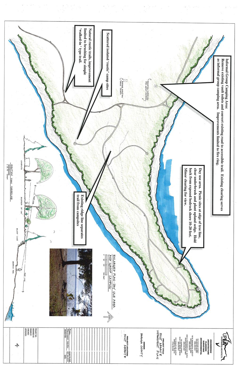
41 Point Abbaye Improvement Plan 2011 Proposed Facilities U.P. Engineers and Architects (UPEA) was contracted to prepare drawings of proposed facilities and develop cost estimates based on Committee input. Following are the proposed improvements: Parking Lot Relocation - The Committee identified the location of the existing parking area as an impediment to restricting vehicle access and as an intrusion to the natural experience. A new parking area (eight vehicles) will be built at a pinch point along the access road and rocks will be installed to restrict vehicle access and mark the beginning of the accessible nonmotorized trail to the point. Boat Launch - The new parking lot location is also situated at a natural shelf where trees will be cleared to allow small boats and kayaks to launch from the rocks. The parking area will be built to the east of the road and include parking for day users and boat trailers/vehicles. This location also allows direct access to Keweenaw Bay for kayaks and canoes. Toilets A new toilet facility is proposed at the main parking area. Trail/Camping Parking A smaller parking lot for eight vehicles (seven cars and one van accessible space) will be installed at the intersection with McBeth Road. This smaller parking lot will serve as an additional trailhead for the Park as well as the proposed trail connecting to surrounding land. It will also be parking for designated primitive campsites to be located on the Huron Bay side of the Peninsula. Trails The trail system will be redesigned to include an accessible trail from the main parking area to the tip and a number of natural/rustic stacked loops will be built that explore various highlights of the property and connect to both trailheads. Spur trails will lead to designated campsites. Designated Primitive Campsites In order to preserve the day use experience, designated campsites (8-10) with cleared tent site and fire rings will be provided where appropriate. One group site is proposed for the Keweenaw Bay side on interior land and two handicap accessible sites near the accessible trail. Signage A number of signs will be needed including: External Directional Signage Improved directional signs will be installed beginning at Skanee and Townline Road with distances to Point Abbaye. Park Sign An arrival sign will be installed at the intersection of Point Abbaye Road and McBeth Road where it clearly announces that users have arrived at the Park. 11
42 Point Abbaye Improvement Plan 2011 Internal Signage All trails will have small confidence signage installed to keep users on pathway. Trailhead Kiosk A trailhead kiosk will be installed at both parking areas. The lakeshore parking area will have additional information for boaters. Information will include area map, rules of use, information on Point Abbaye and other information deemed appropriate. Interpretive Signage Strategically located interpretive signage will be placed to educate users about geology, flora and fauna, Lake Superior, features on the horizon, etc. Road Improvements - The Baraga County Road Commission has indentified the need to improve the drainage and surface of the roads to Point Abbaye. Specific needs and costs are to be determined. Preliminary Designs and Cost Estimates See the next five pages for the preliminary designs and cost projections provided by UPEA for Point Abbaye based on the proposed improvements: 1. Point Abbaye Improvement Plan 2. Enlarged Plan Boat Launch Site 3. Enlarged Plan Trailhead Parking 4. Enlarged Plan Day Use Area and Group Camping 5. Cost Projections 12
43

44
45
46
47 Cost Projections (based on June 22, 2011 Final Plan) Trail, Campsites and Day Use Improvements: includes clearing, grading and aggregate surface for 6 foot wide (accessible) trail. Aggregate handicap accessible trail includes tge section beginning at the lakeside parking lot extending to the point. The trails on the Finlandia Bay side of point are rustic, walked in paths. The work of rustic paths includes clearing, minor grading and signage only. Also includes three foot wide wood boardwalk over wetland area at campsite. Paths to accessible campsites are aggregate at 3 feet wide along accessible paths only. Camping site improvements on rustic paths is limited to a fire ring. Restoration along path edges and at campsites is a seeding of native upland sedges. Miscellaneous trail markers and three interpretive signs are included. Simple benches at trail side and at day use sites are also included. Trail aggregate (1.1 miles)... $45,000 Clearing and grading for rustic trails (1.9 miles).$20,000 Wood Boardwalk (3 wide)... $12,800 Campsite paths and tent pads... $6,500 Campsite and picnic amenities... $15,000 Restoration/landscaping... $18,000 Trail Signage/Trail benches/interpretive signage... $8,500 Lakeside Trailhead: includes clearing, grading and aggregate paving for driveway and 7 parking spaces and one interpretive sign. Also includes landscaping/vehicle barriers and picnic amenities, 1 campsite, and 1 barrier-free unisex toilet. Clearing, grading and paving... $12,000 Accessible unisex vault toilet... $19,000 Trail connection... $500 Boulders, landscape restoration... $3,500 Campsite and picnic amenities... $4,000 Trailhead, T Intersection: includes clearing, grading and aggregate paving for driveway and parking. Also includes one interpretive sign, trail connection and landscape restoration. Clearing, grading and paving... $8,000 Trail Connection... $800 Landscape restoration, signage... $1,200 Subtotals: Trail/Campsites/Day use... $125,800 Lakeside Parking Trailhead... $39,000 T Parking Trailhead... $10,000 Totals: Construction cost.... $174,800 Engineering, permits and fees... 26,000 Project Cost Projection... $200,800
48 Point Abbaye Improvement Plan 2011 FUNDING OPPORTUNITIES Grant opportunities are constantly changing, so the County needs to remain diligent in pursuing funding programs and also be willing to partner in order to accomplish projects. The Baraga County Recreation Plan is the preferred mechanism for prioritizing improvements. Point Abbaye projects to be implemented will be identified in the Recreation Plan. A number of possible sources of funding for recreation projects at Point Abbaye are available and include the following: Description Match Source Local Funds County Community Foundation/Other (local service organizations and businesses) Local Great Lakes Restoration Initiative EPA Michigan Natural Resources Trust Fund (MNRTF)* 75/25 grant DNR Recreation Passport Local Grant Program (MDNR) 75/25 grant DNR Land & Water Conservation Fund (LWCF)* 50/50 grant DNR Boating Infrastructure Grants (BIG) 75/25 grant DNR Coastal Zone Management (CZM) 50/50 grant DEQ Coastal and Estuarine Land Conservation Program (CELCP) 50/50 grant DEQ Miscellaneous Grants/To Be Determined Unknown *To be considered for MNRTF or LWCF grants, projects must be included in an approved 5-year Baraga County Recreation Plan. Components of the improvement plan may also be completed through volunteer time that could be used as match for grant opportunities. 18
49 Appendix B:
50
51 Baraga Recreation Plan Survey We are currently in the process of updating the Baraga County 5 Year Recreation Plan. Your opinions will help guide recreation improvements in Keweenaw County. Surveys will be accepted until October 31, The survey is also available online at 1. What statement best describes your role in Baraga County? ( ) I live in Baraga County ( ) My family owns a seasonal home in Baraga County ( ) I have visited Baraga County ( ) None of the above 2. What are the ages and numbers of persons in your household? 10 and under and up 3. I or a member of my family works in the tourism industry in Baraga County. ( ) Yes ( ) No 4. Is there a person with a disability in your family? If yes, indicate what facilities are in need of accessibility improvements. ( ) Yes ( ) No 5. Please indicate your household income: ( ) $14,999 or less ( ) $15,000-$24,999 ( ) $25,000-$49,999 ( ) $50,000-$74,999 ( ) $75,000-$100,000 ( ) $100,000 or more 6. I have participated in the following recreational activities in Baraga County over the past year (check all that apply): ( ) Boating ( ) Canoe/Kayaking ( ) Rode an ORV (Off Road Vehicle) on trail ( ) Rode a motorcycle on trail ( ) Rode a snowmobile on trail ( ) Used a hiking trail ( ) Mountain biking ( ) Bicycled on the road ( ) Fished on an inland lake ( ) Fished on Lake Superior Page 1 of 4
52 ( ) Stream fishing ( ) Picnicked at a park or other public land ( ) Visited playground ( ) Camped at a public park ( ) Hunting ( ) Fall color tours ( ) Golfing ( ) Birding ( ) Visited a historic site ( ) Rock picking/agate hunting ( ) Swimming ( ) Cross-country skiing/snowshoeing ( ) Geo-caching ( ) Ice skating ( ) Other 7. In the last year I visited the Pt. Abbaye County Park. ( ) Yes ( ) No If yes, what activities did you participate in? Please list (hiking, camping, etc.) 8. Baraga County just completed a Pt. Abbaye Improvement Plan that identified a number of projects to guide improvements and encourage public use of the Park. Please rate the following projects from 1 Most Important to 5 Least Important. Please circle rating for each item. Main Parking Lot Relocation A new parking lot is proposed along a pinch point to the west of the existing parking. The parking would help restrict vehicle access and mark the beginning of a proposed accessible non-motorized trail to the point Improved Trail System The trail system would be redesigned to include an accessible trail from the main parking area to the tip and a number of natural/rustic stacked loops will be built to explore various highlights of the property Expanded Trail System An additional non-motorized trail loop is proposed to connect to adjacent DNR lands and private lands if permissions can be acquired New Toilets A new toilet facility is proposed at the main parking area New Trail/Camping Parking An additional parking lot is proposed for the intersection with MacBeth Road. This lot will serve as an additional trailhead for the Park, parking for the proposed trail connecting to surrounding land and also as parking for primitive campsites on Huron Bay side of Peninsula Designated Primitive Campsites In order to isolate camping from day use users, designated campsites (8-10) are proposed with a cleared tent site and fire rings as appropriate. One group site is Page 2 of 4
53 proposed for the Keweenaw Bay side on interior land and two handicap accessible sites near the proposed accessible trail Natural Boat Launch Enhancements The proposed new parking lot is situated near a natural shelf where trees will be cleared to allow small boats and kayaks to launch from the rocks Signage A number of signs are proposed to enhance the visitor experience including external directional signage, an arrival sign at the intersection of Point Abbaye Road and MacBeth Road, trail signage, trailhead information kiosks and interpretive signage highlighting the features of the site Road Improvements The Point Abbaye Road needs drainage and surface improvements to lessen maintenance and provide for increased use Please rate the quality of the following existing recreational features in Baraga County: Very Good Good Average Poor Very Poor Don t Know ORV Trails ( ) ( ) ( ) ( ) ( ) ( ) Snowmobile Trails ( ) ( ) ( ) ( ) ( ) ( ) Hiking/Biking Trails ( ) ( ) ( ) ( ) ( ) ( ) Canoe/Kayak Launches & Access Points ( ) ( ) ( ) ( ) ( ) ( ) Fishing Access ( ) ( ) ( ) ( ) ( ) ( ) Public Campgrounds ( ) ( ) ( ) ( ) ( ) ( ) Picnicking/Outdoor Gathering Spots ( ) ( ) ( ) ( ) ( ) ( ) Lake Superior Swimming Access ( ) ( ) ( ) ( ) ( ) ( ) Inland Lake Swimming Access ( ) ( ) ( ) ( ) ( ) ( ) Hunting ( ) ( ) ( ) ( ) ( ) ( ) Fall Color Tours ( ) ( ) ( ) ( ) ( ) ( ) Birding ( ) ( ) ( ) ( ) ( ) ( ) Playgrounds ( ) ( ) ( ) ( ) ( ) ( ) Cross Country Skiing/Snowshoeing ( ) ( ) ( ) ( ) ( ) ( ) Heritage Sites ( ) ( ) ( ) ( ) ( ) ( ) Ice Skating ( ) ( ) ( ) ( ) ( ) ( ) Golfing ( ) ( ) ( ) ( ) ( ) ( ) 10. What additional or new recreational features or amenities are needed in Baraga County? (Check all that apply): ( ) More snowmobile trails ( ) More ORV trails ( ) ATV/Motorized scramble area ( ) More hiking trails ( ) More biking trails ( ) Designated horse trails ( ) Paved bicycle pathways ( ) Canoe/kayak launches Page 3 of 4
54 ( ) More campgrounds ( ) More public access along Lake Superior ( ) More inland lake access ( ) More boat launches ( ) More cross country ski trails/snowshoeing ( ) Sledding hill ( ) Playgrounds ( ) Frisbee-golf ( ) Other 11. If you believe the County needs more trails (or trail connections), where should these efforts be focused? 12. What do you like best about parks and recreation in Baraga County? 13. What is one thing you would do to improve parks and recreation in Baraga County? 14. What would you do to make the recreational facilities in Baraga County more user-friendly? 15. Other comments you would like to share regarding recreation in the County? Thank you for taking our survey. Your responses will be used to help guide the revision of the Baraga County Recreation Plan. We thank you for your time and assistance. Please return completed surveys to the Baraga County Courthouse or mail to WUPPDR, P.O. Box 365, Houghton, MI Page 4 of 4
55 Appendix C.: Public notices, minutes, resolution of adoption and transmittal letters
56

57 PRESS RELEASE Western Upper Peninsula Planning and Development Region P.O. Box 365 Houghton, MI Release Date: October 10, 2011 Baraga County Recreation Survey Baraga County is in the process of updating their Five-Year Recreation Plan. Please help them in their planning effort by taking a short survey online at: Paper copies of the survey are available at the Baraga County Courthouse, Clerk s office in L Anse. The survey will be available until Monday, October 31, Thank you to everyone for participating in the survey. For more information, contact: WUPPDR Associate Planner Lori Hauswirth at , ext. 314


58


59


60

61

62

63


64

65
Schoolcraft Township is located in northeast Houghton County. A portion of the township borders Keweenaw County and Lake Superior.
 COMMUNITY DESCRIPTION Schoolcraft Township is located in northeast Houghton County. A portion of the township borders Keweenaw County and Lake Superior. The township is largely rural but has one main population
2. Goals and Policies. The following are the adopted Parks and Trails Goals for Stillwater Township:
 D. PARKS AND TRAILS 1. Introduction Stillwater Township s population is relatively low, with most residents living on rural residences on large lots. The need for active park space has been minimal in
COPPER HERITAGE TRAIL CONCEPTUAL PLAN 2011
 COPPER HERITAGE TRAIL CONCEPTUAL PLAN 2011 A Proposed 40 Mile Non-Motorized Rail Trail Route Connecting The Historic Communities Of the Copper Country Prepared For: Western Upper Peninsula Health Department
Stambaugh Township 5-Year Recreation Plan - DRAFT
 Stambaugh Township 5-Year Recreation Plan - DRAFT Stambaugh Township GEI Project No. 1702677 January 5, 2018 Table of Contents 1. Community Description 1 2. Administrative Structure 2 3. Recreation Inventory
RECREATION PLAN
 L'ANSE VILLAGE & TOWNSHIP 2018-2022 RECREATION PLAN Prepared for: L'Anse Township, 126 N. Main St., L'Anse, MI 49946 Village of L'Anse, 101 N. Main St., L'Anse, MI 49946 Prepared by: Western Upper Peninsula
SAXON HARBOR REDEVELOPMENT SURVEY
 SAXON HARBOR REDEVELOPMENT SURVEY SEPTEMBER, 2016 1,173 RESPONSES 1 BACKGROUND 1. WHAT TYPES OF ACTIVITIES DO YOU ENGAGE IN AT SAXON HARBOR Sightseeing Swimming Picnicing Fishing Camping Photography Motorized
F. Forest Recreation Management
 F. Forest Recreation Management F.1) Park and Recreation Management F.1.A. Program Overview. The park and recreation program has been in existence since 1980. With ever increasing outdoor recreation demands
Chapter eight. Parks and Recreation. Introduction. Crystal Lake Park District
 Chapter eight Parks and Recreation Introduction One of the indicators of quality of life in a city is the parks and recreation system. The City of Crystal Lake is fortunate to have an excellent parks and
10/25/2013. What is the SCORP?! 2013 Local Government Survey 2013 Statewide Public Survey Advisory Group Priority Areas Your Suggestions!
 COLORADO OUTDOOR RECREATION TRENDS RESULTS FROM THE SCORP AND STATEWIDE Colorado Outdoor Recreation Resource Partnership September 2013 PRESENTATION What is the SCORP?! 2013 Local Government Survey 2013
Acquisition in fee simple of approximately one-half acre of property on the shore of Spring Lake to expand the Lakeside Beach Park.
 Lakeside Beach TF00-136 $122,550.00 in fee simple of approximately one-half acre of property on the shore of Spring Lake to exp the Lakeside Beach. 2000 River Ravines TF00-150 $910,000.00 in fee simple
4.0 OUTDOOR RECREATION 4.1 PUBLIC LANDS
 4.0 OUTDOOR RECREATION 4.1 PUBLIC LANDS Public lands provide a wide range of recreational opportunities and are considered a valuable community asset. There may be seasonal and/or other use restrictions
Crystal Lake Area Trails
 Lake Area Trails Welcome to the Lake area of the Big Snowy Mountains! This island mountain range in central Montana features peaks reaching to 8,600 feet and long, high ridges from which vistas of the
NORTHWEST SECTION CONTENTS: CLEVELAND PARK FOLWELL PARK RYAN LAKE PARK VICTORY PRAIRIE DOG PARK VICTORY PARK
 NORTHWEST SECTION CONTENTS: CLEVELAND PARK FOLWELL PARK RYAN LAKE PARK VICTORY PRAIRIE DOG PARK VICTORY PARK LUCY LANEY COMMUNITY SCHOOL N 33RD AVE N 33RD AVE SINGLE-FAMILY RESIDENTIAL MULTI-USE DIAMOND
Port Gamble Shoreline Area Conceptual Trail Proposal
 The North Kitsap Trails Association is pleased to be a partner to the Kitsap Forest and Bay Project and assist Kitsap County, Forterra, Olympic Property Group, Great Peninsula Conservancy and the Port
FINAL TESTIMONY 1 COMMITTEE ON RESOURCES UNITED STATES HOUSE OF REPRESENTATIVES. July 13, 2005 CONCERNING. Motorized Recreational Use of Federal Lands
 FINAL TESTIMONY 1 STATEMENT OF DALE BOSWORTH CHIEF Of the FOREST SERVICE UNITED STATES DEPARTMENT OF AGRICULTURE Before the SUBCOMMITTEE ON FORESTS AND FOREST HEALTH And the SUBCOMMITTEE ON NATIONAL PARKS,
Northeast Quadrant Distinctive Features
 NORTHEAST QUADRANT Northeast Quadrant Distinctive Features LAND USE The Northeast Quadrant includes all the area within the planning area that is east of Interstate 5 and to the north of State Route 44.
CHAPTER 5. Chapter 5 Recreation Element
 CHAPTER 5 Recreation Element Chapter 5 Recreation Element The Recreation Element of the Meyers Area Plan is a supplement to the Recreation Element of the TRPA Regional Plan and the El Dorado County General
Camping (Primitive) Camping (RV) Electrical Potable Water Grill Established Fire Pit Picnic Table
 Camping (RV) Electrical Potable Water Grill Established Fire Pit Picnic Table") Alden - 9th Road River Mile 777 Map: 38.20833, -98.32031 Managing Agency: Kansas Department of Wildlife, Parks & Tourism Nearest Community: Alden, Rice County Kansas Developed Amenities Provided Parking
Alden - 9th Road River Mile 777 Map: 38.20833, -98.32031 Managing Agency: Kansas Department of Wildlife, Parks & Tourism Nearest Community: Alden, Rice County Kansas Developed Amenities Provided Parking
Osceola Township Recreation Plan
 Osceola Township Recreation Plan 2011-2015 Adopted January 13, 2011 Prepared for: Osceola Township P.O. Box 437 Dollar Bay, MI 49922 Prepared by: Western U.P. Planning & Development Region P.O. Box 365
Summary of Recreation Sites Development Name:
 Development Name: Eau Pleine Site Number: 1 Owner: WVIC Eau Pleine Tailwater Boat Launch Lanes 1 Concrete plank landing, access to Eau Pleine tailwater & Lake DuBay. (45 planks long, 62.5') Picnic Tables
J. Recreation Plan of Conservation and Development. The Town of Hebron. Section 2. Preservation of Unique Assets. 1 P a g e
 The Town of Hebron Section 2 2014 Plan of Conservation and Development Preservation of Unique Assets J. Recreation Open spaces, parks, sports fields, and recreational programs are considered essential
System Group Meeting #1. March 2014
 System Group Meeting #1 March 2014 Meeting #1 Outcomes 1. Understand Your Role 2. List of Revisions to Existing Conditions 3. Information Sources Study Area The Purpose of Mountain Accord is to Preserve
NORTH OF BROADWAY SECTION CONTENTS: COTTAGE PARK FARVIEW PARK GLEN GALE PARK IRVING TRIANGLE JORDAN PARK NEWTON PARK PERKINS HILL PARK
 NORTH OF BROADWAY SECTION CONTENTS: COTTAGE PARK FARVIEW PARK GLEN GALE PARK IRVING TRIANGLE JORDAN PARK NEWTON PARK PERKINS HILL PARK N ILIO NA VE N JAM ES AV E PLAYGROUND PAR K PRO PER TY B OUN DAR Y
Header i
 Header i 048285014.10 Header Sub Title Body Text here. Body text here. Body text here. Section 1... 1 Executive Summary... 1 Opportunities and Constraints... 3 Overall Opportunities and Constraints Map
Welcome to the future of Terwillegar Park a Unique Natural Park
 Welcome to the future of Terwillegar Park a Unique Natural Park 1 Introduction The Terwillegar Park Concept Plan study will develop an overall concept plan, management objectives and development guidelines
City of Durango 5.8 FUNDING TRAILS DEVELOPMENT
 5.8 FUNDING TRAILS DEVELOPMENT The City has been successful in establishing dedicated local funding sources as well as applying for grants to develop the City s trail system, having received nearly $2.4
National Recreation Trail Application for Designation
 National Recreation Trail Application for Designation Introduction Thank you for your interest in the National Recreation Trail (NRT) program. Completed NRT application packages must be submitted by December
The City of Durango Community Interest and Opinion Survey Executive Summary
 The City of Durango Community Interest and Opinion Survey Executive Summary Overview ETC Institute administered a community interest and opinion survey for the City of Durango between January and March
Silver Lake Park An Environmental Jewel for the Citizens of Prince William County
 Silver Lake Park An Environmental Jewel for the Citizens of Prince William County The Prince William Park Authority Mission Statement states: The Prince William County Park Authority will create quality
Airport Planning Area
 PLANNING AREA POLICIES l AIRPORT Airport Planning Area LOCATION AND CONTEXT The Airport Planning Area ( Airport area ) is a key part of Boise s economy and transportation network; it features a multi-purpose
MASTER PLAN EXECUTIVE SUMMARY
 Biscuit Run State Park Scottsville Road (State Route 20) Charlottesville, VA 22902 Biscuit Run State Park MASTER PLAN EXECUTIVE SUMMARY Department of Conservation and Recreation Division of Planning and
TOURISM & PUBLIC SERVICES RURAL SIGNAGE POLICY
 Policy and Procedures Subject Title: Tourism and Public Services Rural Signage Policy Corporate Policy (Approved by Council): X Policy Ref. No.: ROADS-01-07 Administrative Policy (Approved by CAO): By-Law
Yuba Creek Natural Area Acquisition. Acme Township. Acme Township. TF Acquisition $1,576, Grand Traverse
 Yuba Creek Natural Area TF00-162 $1,576,021.00 in fee simple of 403 acres of critical wetls upl habitat with over 5,000 feet of frontage on Yuba Creek, a tributary to the east arm of Bay. 2000 Petobago
Preferred Recreation Recommendations Stemilt-Squilchuck Recreation Plan March 2018
 Preferred Recreation Recommendations Stemilt-Squilchuck Recreation Plan March 2018 Below are the recommended recreation ideas and strategies that package together the various recreation concepts compiled
Logo Department Name Agency Organization Organization Address Information 5700 North Sabino Canyon Road
 Logo Department Name Agency Organization Organization Address Information United States Forest Coronado National Forest 5700 North Sabino Canyon Road Department of Service Santa Catalina Ranger District
Chapter 6. Action Program. Heart of the Lakes Area Recreation Plan
 Heart of the Lakes Area Recreation Plan 1. Design and construct the following trails (please see the following map): a. the Speedway Trail 1) primary pathway the main trail 2) secondary pathway the proposed
4MRV Parks Master Plan: Site Analysis
 4MRV Parks Master Plan: Site Analysis Lardner/Klein Landscape Architects in association with: RK&K Grimm + Parker Kittelson & Associates Partners for Economic Solutions RIB U.S.Cost Civil Engineering Architecture
ANAGEMENT. LAN November, 1996
 M ANAGEMENT P LAN November, 1996 for Paul Lake Provincial Park Ministry of Environment, Lands and Parks BC Parks Department Paul Lake Provincial Park M ANAGEMENT P LAN Prepared by BC Parks Kamloops Area
Understanding the caring capacity of the visitor experience Provide facilities to support a high level user experience Address visual quality through
 Understanding the caring capacity of the visitor experience Provide facilities to support a high level user experience Address visual quality through recreation ecological restoration opportunities Collaboration
WASHINGTON STATE PARKS LAND CLASSIFICATION SYSTEM
 WASHINGTON STATE PARKS LAND CLASSIFICATION SYSTEM Administrative Code Establishing Land Classification System WAC 352-16-020 Land classification system. State park areas are of statewide natural, cultural,
Arthur Carhart National Wilderness Training Center s Wilderness Investigations High School
 Arthur Carhart National Training Center s Investigations High School 101/Lesson 2 (OPTION 2B) Introducing the Act Goal: Students will understand the difference between wild spaces and federally designated
Appendix A BC Provincial Parks System Goals
 Appendix A BC Provincial Parks System Goals The British Columbia Provincial Parks System has two mandates: To conserve significant and representative natural and cultural resources To provide a wide variety
TAYLOR CANYON RANCH COLORADO - ROUTT COUNTY - STEAMBOAT SPRINGS
 TAYLOR CANYON RANCH COLORADO - ROUTT COUNTY - STEAMBOAT SPRINGS Tucked up against the steep valley shaped by Mt. Pau and rising to the Routt National Forest, Taylor Canyon Ranch is an easily accessible,
Trail Etiquette. Hours of Operation. Trail Accessibility
 Trail Guide The Elmhurst Park District, with 28 parks and over 460 acres of land, offers nearly six miles of paved or asphalt park trails and maintains an additional 3.6 miles of trails within Elmhurst.
Park Design and Location Criteria
 Park Design and Location Criteria This section is presented in the interest of assisting park and recreation agencies in the development of a system of parks and recreation areas. A recreation system is
KEWEENAW COUNTY RECREATION PLAN
 KEWEENAW COUNTY RECREATION PLAN 2011-2015 Prepared for: Keweenaw County Board of Commissioners 5095 4 th Street Eagle River, MI 49950 By: Western Upper Peninsula Planning and Development Region P.O. Box
AGENDA ITEM 5 D WAKULLA ENVIRONMENTAL INSTITUTE (WEI) TRAIL FEASIBILITY STUDY
 TRAIL FEASIBILITY STUDY") March 19, 2018 AGENDA ITEM 5 D WAKULLA ENVIRONMENTAL INSTITUTE (WEI) TRAIL FEASIBILITY STUDY TYPE OF ITEM: Action STATEMENT OF ISSUE The Wakulla Environmental Institute (WEI) Trail is one of several trails
March 19, 2018 AGENDA ITEM 5 D WAKULLA ENVIRONMENTAL INSTITUTE (WEI) TRAIL FEASIBILITY STUDY TYPE OF ITEM: Action STATEMENT OF ISSUE The Wakulla Environmental Institute (WEI) Trail is one of several trails
Chapter 9 Recreation
 Chapter 9 Chapter 9 1.0 INTRODUCTION The Town of Littleton is within one of New England s most important recreation areas. More than three million people live within 100 miles of the area. Local residents
CHAPTER 4 EXISTING PARKS AND RECREATION FACILITIES INVENTORY
 CHAPTER 4 EXISTING PARKS AND RECREATION FACILITIES INVENTORY Existing park and recreation sites and facilities provide the basis upon which to build a park and recreation plan for the city. This inventory
Cascade River State Park Management Plan Amendment
 This document is made available electronically by the Minnesota Legislative Reference Library as part of an ongoing digital archiving project. http://www.leg.state.mn.us/lrl/lrl.asp Cascade River State
Lake Myra County Park. Wake County, North Carolina Community Forum #2 June 12, 2008
 Lake Myra County Park Wake County, North Carolina Community Forum #2 June 12, 2008 Welcome and Introduction Meeting Agenda Welcome Introductions of Project Team Master Plan Process Community Forum #1 Updates
O REGON TRAILS SUMMIT. Oregon Trails Summit. Rogue River National Forest
 O REGON TRAILS SUMMIT Oregon Trails Summit 2014 Rogue River National Forest OREGON TRAILS 2015: A VISION FOR THE FUTURE The 2015-2024 Oregon Statewide Trails Plan Why do a trails plan? 2005-2014 Oregon
PIONEER PARK. City of Des Peres Parks Master Plan. SWT Design 46 INTRODUCTION
 PIONEER PARK INTRODUCTION Pioneer Park is a 7 acre neighborhood park located east of Interstate 270 and south of Manchester Road along Tallie Road. The park is situated in a residential neighborhood with
National Recreation Trail Update Form
 National Recreation Trail Update Form Introduction Thank you for taking the time to complete this form. Your assistance will help ensure that the National Recreation Trail (NRT) database is complete and
PURPOSE AND NEED. Introduction
 Public Scoping: Allocation of Recreation Capacity for Commercial Outfitter Guide Services on North Kruzof Island Trails (Kruzof Island Outfitter Guide) PURPOSE AND NEED Introduction The U.S. Department
Lincoln County ORP Survey Response Summary
 Lincoln County ORP Survey Response Summary North Central Wisconsin Regional Planning Commission Q1 Which recreational activities did you participate in during 2015? (Choose all that apply.) Answered: 125
Dungeness Recreation Area County Park Master Plan
 Dungeness Recreation Area County Park Public Outreach Meeting October 10, 2007 Project Overview USFWS Site Dungeness Recreation Area County Park Meeting Objectives: Re-Introduce project; provide status
City of Haslett. City of East Lansing. City of East Lansing
 Central Park North (Nancy L. Moore Park) Lake Park North Expansion White Park Expansion #2 White Park Expansion #1 County East East Haslett East East TF87-212 Acquisition $90,000.00 Park. TF08-138 Acquisition
GATEWAY PHASE 2. U.S. Forest Service and the Mount Shasta Trails Association
 GATEWAY PHASE 2 U.S. Forest Service and the Mount Shasta Trails Association PROJECT DEVELOPMENT Brief history - Gateway Phase 1 - IMBA conceptual plan - BikeShasta: concert series - USFS & MSTA partnered
Non-Motorized Transportation
 Non-Motorized Transportation Non-motorized facilities are important components to the transportation system. They provide an environmentally-friendly, low-cost mode of travel. Some of the facilities can
Proposal to Redevelop Lower Kananaskis River-Barrier Lake. Bow Valley Provincial Park. Frequently Asked Questions
 Proposal to Redevelop Lower Kananaskis River-Barrier Lake Bow Valley Provincial Park Frequently Asked Questions What is being proposed? What are the details of the proposal? Where is the project area located?
City of Chelan Shoreline Public Access Plan
 City of Shoreline Public Access Plan This City of Shoreline Public Access Plan documents how the City has planned for parks and recreation in the community, particularly along Lake and the River. This
Clearwater Lake Provincial Park. Draft Management Plan
 Clearwater Lake Provincial Park Draft Management Plan Clearwater Lake Provincial Park Draft Management Plan Table of Contents 1. Introduction... 3 2. Park History... 4 3. Park Attributes... 4 3.1 Location/Access...4
Dakota County Planning Commission Advisory Committee Meeting Minutes Date: May 23, 2017 Time: 6:00 p.m. to 8:30 p.m.
 Dakota County Planning Commission Advisory Committee Meeting Minutes Date: May 23, 2017 Time: 6:00 p.m. to 8:30 p.m. Members Present Staff Present Mike Greco Trinity Augesen Vacant Lori Hansen Jill Smith
Dumont Dunes Special Recreation Management Area (SRMA)
") Dumont Dunes Special Recreation Management Area (SRMA) RMA/RECREATION MANAGEMENT ZONE (RMZ) OBJECTIVE(S) DECISIONS Objective Statement: Designate this area as a Special Recreation Management Area. To manage
Dumont Dunes Special Recreation Management Area (SRMA) RMA/RECREATION MANAGEMENT ZONE (RMZ) OBJECTIVE(S) DECISIONS Objective Statement: Designate this area as a Special Recreation Management Area. To manage
New Haven-Adams Twp Parks & Recreation Dept Citizen Survey
 New Haven-Adams Twp Parks & Recreation Dept Citizen Survey Monday, October 02, 2017 281 Total Responses Date Created: Thursday, July 13, 2017 Complete Responses: 243 Q1: Do you live in New Haven-Adams
Watchorn Provincial Park. Management Plan
 Watchorn Provincial Park Management Plan 2 Watchorn Provincial Park Table of Contents 1. Introduction... 3 2. Park History... 3 3. Park Attributes... 3 3.1 Natural... 4 3.2 Recreational... 4 3.3 Additional
A Vision for South Skunk River and Chichaqua Bottoms Greenbelt
 A Vision for South Skunk River and Chichaqua Bottoms Greenbelt Photo: Jim Pease Chichaqua Bottoms Booklet 7 of 8 Greater Des Moines Water Trails and Greenways 1 2016 Table of Contents Booklet 1: Water
Rating: 5.0 (scale of 1-10)
") 95 Community Trail System Groundcover: 2-metre paved path, 1- metre grass buffer on either side. Location: Fort St. John Ownership: City of Fort St. John Rating: 5.0 (scale of 1-10) Strategic value: Linear
95 Community Trail System Groundcover: 2-metre paved path, 1- metre grass buffer on either side. Location: Fort St. John Ownership: City of Fort St. John Rating: 5.0 (scale of 1-10) Strategic value: Linear
Greater Minnesota Regional Parks and Trails Commission Designation Application
 Greater Minnesota Regional Parks and Trails Commission Designation Application General Section Designation Application #: 15-059D Date Submitted: 06/16/2015 Park or Trail Name: Mesabi Trail District #:
Village of Stockholm
 Village of Stockholm 2016 Plan for the Community Park Park Committee: Harley Cochran Mark Coronna Steve Grams Jerry Larson Hap Palmberg FINAL: FOR VILLAGE BOARD APPROVAL March 8, 2016 1 Table of Contents
Blueways: Rivers, lakes, or streams with public access for recreation that includes fishing, nature observation, and opportunities for boating.
 Parks, Open Space and Trails PRINCE WILLIAM COUNTY 2008 COMPREHENSIVE PLAN TRAILS PLAN CONTENTS The components of the trails plan are: Intent Definitions Goals, Policies, and Action Strategies Trails Map
Rogue River Access and Management Plan Draft Alternatives
 Rogue River Access and Management Plan Draft Alternatives The Rogue River Access and Management Plan was initiated in December, 2011 and is being led by Jackson County Parks (JCP) and Oregon Department
OAKLAND TOWNSHIP PARKS AND RECREATION MILLAGE RENEWAL AUGUST 2, 2016 BALLOT PROPOSAL QUESTIONS & ANSWERS PULL-OUT SECTION (APRIL 21, 2016)
") OAKLAND TOWNSHIP PARKS AND RECREATION MILLAGE RENEWAL AUGUST 2, 2016 BALLOT PROPOSAL QUESTIONS & ANSWERS PULL-OUT SECTION (APRIL 21, 2016) 2007 2016 Millage Accomplishments Timeline in Pull-out The Mission
OAKLAND TOWNSHIP PARKS AND RECREATION MILLAGE RENEWAL AUGUST 2, 2016 BALLOT PROPOSAL QUESTIONS & ANSWERS PULL-OUT SECTION (APRIL 21, 2016) 2007 2016 Millage Accomplishments Timeline in Pull-out The Mission
Hampton Township. Community Description
 Hampton Township Community Description Hampton Township is located in southern Bay County, east of Bay City and Essexville. It contains approximately 9 miles of Saginaw Bay shoreline and 1.5 miles of Saginaw
POLICY DCS-04: Tourism Directional Sign Policy. Development and Cultural Services
 DCS-04 Page 1 of 8 POLICY DCS-04: Tourism Directional Sign Policy Development and Cultural Services Approval Date: March 11, 2008 Approval Authority: Council, Resolution No. 7 Effective Date: March 11,
Stephens Rd. Nature Preserve
 Stephens Rd. Nature Preserve History Stephens Road Nature Preserve (SRNP) is a 350-acre nature preserve in Huntersville that comprises nine properties purchased between 1994 and 2008. Parcels included
Public Park System. Township of Derry. Providing natural open space for the recreational use of our residents and guests.
 Township of Derry Public Park System Providing natural open space for the recreational use of our residents and guests. Directory of Recreational Amenities Hershey s Commitment to Recreation Famous candy
482 :fi6 D34 --' v.i9 ~
 '- SB 482 :fi6 D34 --' v.i9 ~ This document is made available electronically by the Minnesota Legislative Reference Library as part of an ongoing digital archiving project. http://www.leg.state.mn.us/lrl/lrl.asp
East Carolina Council Facility Study East Carolina Scout Reservation Camp Boddie Pamlico Sea Base
 East Carolina Council Facility Study East Carolina Scout Reservation Camp Boddie Pamlico Sea Base 1 VISION OF CAMP BODDIE EAST CAROLINA SCOUT RESERVATION 1. Attract Out Of Council Troops Use our natural
This section of the Plan provides a general overview of the Smoky Mountain Region. It consists of the following four subsections:
 SECTION 3 COMMUNITY PROFILE This section of the Plan provides a general overview of the Smoky Mountain Region. It consists of the following four subsections: 3.1 Geography and the Environment 3.2 Population
CRANE LAKE TRAILS NETWORK AND SPACES
 CRANE LAKE TRAILS NETWORK AND SPACES AREA TRAILS COMMUNITY TRAILS GOLD COAST TRAIL LAKE PARK OPTION ONE LAKE PARK OPTION TWO OVERFLOW TRAILHEAD PARKING THE GATE AREA TRAILS Trails are a major resource
Parks & Recreation Areas Program
 PARKS & RECREATION Parks & Recreation Areas Program As part of its mission to conserve and protect natural resources, the Upper Big Blue Natural Resources District (NRD) has been involved in several large-scale
Stony Creek Master Plan Public Meeting #2. May 21, 2016
 Stony Creek Master Plan Public Meeting #2 May 21, 2016 Today s Agenda 10:00 10:20 am Presentation 10:20 10:45 am Q & A 10:45 11:30 am Browse, discuss, and comment Metroparks Master Plan Process 4 months
Georgetown-Lewes Rail/Trail Study. Rail/Trail Study: Cool Spring to Cape Henlopen State Park New Road Extension (House Resolution No.
 Georgetown-Lewes Rail/Trail Study Rail/Trail Study: Cool Spring to Cape Henlopen State Park New Road Extension (House Resolution No. 47) August 22, 2011 Presentation Outline Background Benefits Statewide
Proposal to Redevelop Lower Kananaskis River-Barrier Lake. Bow Valley Provincial Park
 Frequently Asked Questions Proposal to Redevelop Lower Kananaskis River-Barrier Lake Bow Valley Provincial Park Frequently Asked Questions What has been decided? What are the details of the plan? What
THE SETTING REGION COMMUNITY ANALYSIS
 THE SETTING REGION COMMUNITY ANALYSIS REGION Historical Setting The Crane Lake waterway pre-dates the American Indians who traveled its waters for generations before it became a fur-trading route for the
Maple Grove, beach home 10 min. to Traverse City, 20 min. to Sleeping Bear
 Maple Grove, beach home 10 min. to Traverse City, 20 min. to Sleeping Bear Summary Sandy beach, 3 bdrm, 2 bath, fireplace, central air, WiFi, 10 minutes to Traverse City, 20 minutes from Sleeping Bear
Conservation Area Management Statement
 Conservation Area Management Statement Miller Creek Wildlife Area Resolution #: Approval: Issue Date: Date of Last Revision: Table of Contents 1. Purpose....... 1 2. Property Description...... 1 2.1. Legal
Eastern Lake Ontario Beach User Survey 2003/2004.
 Eastern Lake Ontario Beach User Survey 2003/2004. Introduction The eastern shore of Lake Ontario is a Biodiversity Investment Area that features a 17-mile long barrier beach of Great Lakes dunes and a
Tahoe Donner Association Public Scoping Meeting DUDEK
 Tahoe Donner Association Public Scoping Meeting DUDEK Introduction Purpose of this Meeting: Solicit feedback and ideas from members, and staff as we begin the Association Master Plan. Association Master
13.1 REGIONAL TOURISM ISSUES AND SUMMARY OF FINDINGS
 13 REGIONAL TOURISM T he County of Mariposa s recreation needs and facilities fall within two categories: regional tourism and local recreation. This Element focuses on regional tourism issues related
Hermosa Area Preservation The Colorado Trail Foundation 4/11/2008
 Hermosa Area Preservation The Colorado Trail Foundation 4/11/2008 Legend d o Tr ail NPA - National Protection Area ra NCA - National Conservation Area o e C Th The Colorado Trail lo FS inventoried Roadless
MANAGEMENT DIRECTION STATEMENT June, 1999
 Thompson River District MANAGEMENT DIRECTION STATEMENT June, 1999 for Roche Lake Provincial Park Ministry of Environment Lands and Parks BC Parks Division Table of Contents I. Introduction A. Setting
TRUCKEE TAHOE AIRPORT DISTRICT BOARD OF DIRECTOR STAFF REPORT
 AGENDA ITEM: 11 TRUCKEE TAHOE AIRPORT DISTRICT BOARD OF DIRECTOR STAFF REPORT AGENDA TITLE: MEETING DATE: January 24, 2018 PREPARED BY: NTPUD Agency Partnership Opportunity, Multi-Use Trailhead Access
University Region Non-Motorized Plan 2015
 Non-Motorized Transportation Non-motorized facilities are important components to the transportation system. They provide an environmentally-friendly, low-cost mode of travel. Some of the facilities can
EMPLOYMENT OPPORTUNITY. Police Chief. Buena Vista Charter Township
 EMPLOYMENT OPPORTUNITY Police Chief Buena Vista Charter Township Police Chief BUENA VISTA CHARTER TOWNSHIP Buena Vista Charter Township is located in Saginaw County, Michigan. The township strives to be
TOWN OF CANANDAIGUA PARKS AND RECREATION MASTER PLAN PUBLIC OPINION QUESTIONNAIRE
 TOWN OF CANANDAIGUA PARKS AND RECREATION MASTER PLAN PUBLIC OPINION QUESTIONNAIRE The Town of Canandaigua is updating its Parks and Recreation Master Plan. As part of our effort to plan for your future
THOMAS A. SWIFT METROPARK Introductions History Present Conditions Future Development Plans Implementation Strategies Statistics
 THOMAS A. SWIFT METROPARK Introductions History Present Conditions Future Development Plans Implementation Strategies Statistics Introduction As an open meadow park positioned along the Mahoning River,
Picture your next event in Novi!
 Picture your next event in Novi! Facility Reservation Guide Why Novi? Thank you for considering Novi as the location for your next event. We look forward to welcoming you at one of our unique venues which