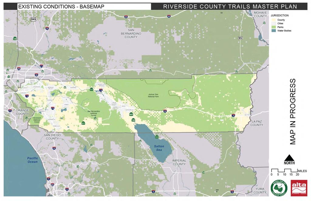
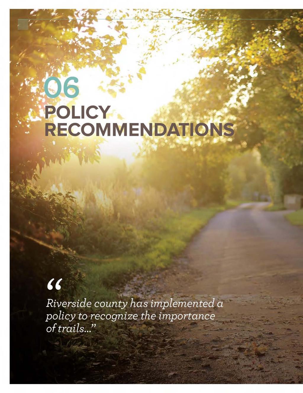
INTRODUCTION. Today, this system has grown to include six trail classifications and almost 2,300 miles of trail.
|
|
|
- Neil Hubert Singleton
- 5 years ago
- Views:
Transcription
1

2 2
3

4 01 INTRODUCTION Today, this system has grown to include six trail classifications and almost 2,300 miles of trail. 4
5

6 6 02 OVERVIEW
7
8 8 May 2017 RIVERSIDE COUNTY REGIONAL PARK AND OPEN-SPACE DISTRICT COMPREHENSIVE TRAILS PLAN Specific opportunities and challenges have been identified through these methods, which manifest in both physical and societal forms. Stakeholders, and managing agencies have been involved in a collaborative planning process leading to the development of a plan with clear policies, operational and maintenance requirements, implementation guidance, funding and partnership recommendations, and design standards for trail typologies appropriate for a regional trail system. Provide an analysis of current trail segments, catalogue the District s inventory of existing trails and trail classifications, and verify trail status; Analyze system gaps, with associated property rights and approaches for acquisition, where necessary; Develop sustainable trail design guidelines which refine current standards and are compatible with adjacent trail networks; Examine key policy issues related to trails such as: land use, easements, liability, unsanctioned use, illegal motorized trail use; Develop a plan for trail implementation and phasing; Define the District s role as lead agency or manager of the County trails program, and identify opportunities for other agencies to assume responsibility for the trail network; Identify potential trail partnerships and recommend immediate and long-term funding models; Provide a framework of recommendations that will serve as a blueprint for future trails planning, maintenance, and development; Base recommendations on input from stakeholders, other trail agencies, and local trail users.
9 Chapter 2 OVERVIEW 9 The Trails Plan provides policies and standards to encourage and promote new trails and recommend improvements to existing trails. Factors taken into consideration include circulation, accessibility and connectivity, and property rights. The Trails Plan incorporates information from the existing twenty-one regional area plan trail systems, to inform existing conditions and planning context within the plan area, with an inventory of existing and mapped trails, preferred trail alignments including needs, and the identification of gaps and missing segments required to improve connectivity. The Trails Plan analyses of potential new trails and connectors where important linkages are made between the regional trail system and local trails and destinations.

10 10 03 EXISTING CONDITIONS

11
12 12 May 2017 RIVERSIDE COUNTY REGIONAL PARK AND OPEN-SPACE DISTRICT COMPREHENSIVE TRAILS PLAN Riverside county is the fourth largest county in the state Riverside County is divided into eastern and western halves by the San Jacinto and Santa Rosa Mountains. The San Gorgonio Pass, framed by the San Jacinto and San Gorgonio Mountains, creates a corridor that links these two halves. The San Bernardino and Little San Bernardino Mountains form a portion of the northern boundary while numerous mountain ranges, including those in the Santa Rosa Wilderness and Cleveland National Forest, serve as boundaries along the southern and western edges of the county. These eastern and western halves of the county are distinguished by their physical characteristics as well as their historic growth patterns. The western portion of the county is roughly half the size of the eastern half and is bounded by the Santa Ana Mountains and Cleveland National Forest on the west and the San Jacinto Mountains and the San Bernardino National Forest on the east. Compared to eastern Riverside County, the western portion of the county contains the greatest concentration of population and has experienced the greatest growth pressures. The eastern side of the County is bounded by the Colorado River on the east and the Santa Rosa and San Jacinto Mountains on the west. This portion of the county is known for its desert terrain and has relatively less populated communities. Joshua Tree National Park forms a natural boundary at the northern end of the Coachella Valley. A vast expanse of desert wilderness separates the Coachella Valley from the Colorado River. The city of Blythe is located in the Palo Verde Valley along the Colorado River, which provides the source for one of the most productive agricultural regions in the county.
13
14

15

16 16 May 2017 RIVERSIDE COUNTY REGIONAL PARK AND OPEN-SPACE DISTRICT COMPREHENSIVE TRAILS PLAN Privately owned lands account for 30% of land in the area, the next largest landowner category in Riverside County. This land could be used for commercial, residential, agricultural, or other purposes. Some privatelyowned land could be used for quasi-public, privately owned trails. This is not as common as publicly owned and operated trails. Privately owned trails may have more use restrictions or not allow sufficient public access. Additionally, this land could also include easements for other uses that could affect the use of the land. City, county and state property make up approximately 6% of lands in the County. These lands could very well have trails, but also likely have smaller parcels to utilize when compared to the federal government. Additional landowners owning less than 3% of the land in the county are utilities, public lands, trusts, tribal lands and other landowners that are not readily categorized. LAND USE CONTEXT Riverside County is the fourth largest county in California and has a number of different natural settings and ecosystems. These settings have a large impact on the possible land uses for the county, and also provide for unique opportunities to develop trails. The County is also home to a number of public landowners with large amounts of potential places for future trails. This has has helped to shape the land use in certain areas of the county. A significant amount classifications for tribal lands is also reflected in the county s land use classification. Nevertheless, due to the large amount of lands in the District, this also presents a management concern as trails need to be managed efficiently and interconnected. Western Riverside County is one of the more densely populated areas of the county. This area borders the Santa Ana Mountains, a natural area which provides for a significant amount of land classified as open space or conservation. Some tribal lands are also located around these communities in rural areas. Closer to the center of Riverside County lays the San Jacinto Mountain Range. This range divides western from central Riverside County and also encloses the municipalities located between this range and the Joshua Tree National Forest. This area is home to the Palm Valley, a national destination for golfers and other recreationalists. A majority of Riverside s population also resides in this area, some with second homes, retirement, or other leisurely lifestyles being the focal point of the area. This makes for many land uses consistent with low density residential with commercial centers located throughout the Valley.
17 Chapter 1 INTRODUCTION 17 AREA PLAN BOUNDARIES The Riverside County General Plan covers the entire unincorporated portion of the County of Riverside and is supplemented by 19, more detailed Area Plans covering Riverside County with the exception of the undeveloped desert areas and the March Air Joint Reserve Base. The purpose of the General Plan is to manage the overall pattern of development more effectively. The Area Plans provide a clear and more focused opportunity to enhance community identity within the County of Riverside and stimulate quality of life at the community level. Table 3-1. AREA PLAN Desert Center Eastern Coachella Valley Eastvale Elsinore Harvest Valley-Winchester Highgrove Jurupa Valley Lake Mathews-Woodcrest Lakeview-Nuevo Mead Valley Palo Verde Reche Canyon-Badlands Riverside Extended Mountain (REMAP) San Jacinto Valley Southwest Sun City-Menifee Valley Temescal Canyon The Pass Western Coachella Valley CITIES/COMMUNITIES Desert Center Coachella, Mecca Eastvale, southwestern edge of Jurupa Valley Lake Elsinore, Wildomar, Canyon Lake Northeast corner of Menifee, Winchester, Homeland Highgrove, University City Jurupa, northeastern edge of Eastvale Lake Mathews, Woodcrest Lakeview, Nuevo Perris, Mead Valley Blythe Moreno Valley N/A San Jacinto, Hemet Temecula, Murrieta Menifee, Sun City Corona, Temescal Valley, El Cerrito Calimesa, Beaumont, Banning, Desert Hot Springs, Palm Springs, Cathedral City, Rancho Mirage, Palm Desert, Indian Wells, La Quinta, Indio, Indio Hills

18 RIVERSIDE COUNTY TRAILS MASTER PLAN EXISTING CONDITIONS - AREA PLANS 40 Z 138 Z 210 Z Water Bodies Æ Ã 66 Æ Ã 62 Æ Ã MAP IN PROGRESS Jurupa Area Plan 83 Æ Ã Eastvale Area Plan Temescal Canyon Area Plan Z 15 5 Parks 0 71 Æ Ã Z Cities 2 5 Z 90 Æ Ã County Area Plan Boundary SAN BERNARDINO COUNTY Ã Æ Æ Ã JURISDICTION 95 Æ Ã Z Z 395 MOHAVE COUNTY 40 ORANGE COUNTY 74 Æ Ã Highgrove Area Plan Cities of Riverside and Norco Area Plan March Area Plan Lake Mathews / Woodcrest Area Plan Reche Canyon / Badlands Area Plan The Pass Area Plan 60 Æ Ã 0 Joshua Tree National Park REMAP Area Plan Harvest Valley / Winchester Area Plan San Bernardino National Forest Z Æ Ã Southwest Area Area Plan Ã Æ East County Desert Area Area Plan Desert Center Area Plan Western Coachella Valley Area Plan San Jacinto Valley Area Plan Sun City / Menifee Valley Area Plan Cleveland National Forest Z 111 Lakeview / Nuevo Area Plan Mead Valley Area Plan Elsinore Area Plan Ã Æ Ã Æ 86S Ã Æ 195 Palo Verde Valley Area Plan Z 10 Z Eastern Coachella Valley Area Plan 0 LA PAZ COUNTY 371 SAN DIEGO COUNTY Ã Æ Æ Ã 79 Æ Ã Z Salton Sea 15 Pacific Ocean N IMPERIAL COUNTY Æ Ã Æ Ã 0 Z Z 805 Z 8 94 Æ Ã Z 8 86 Æ Ã Z 8 YUMA COUNTY MILES 20
19
20
21 Chapter 1 INTRODUCTION 21 National Park Service (NPS): The NPS operates Joshua Tree National Park, which offers a large amount of recreational facilities within the unit. The park serves as a preserve to the Colorado and Mojave Deserts, both are rare ecosystems that provide for scientific study and interpretation. Due to the parks its remote location, it is generally unable to connect to outside recreational facilities as part of a trail network. The park is home to a number of different trails, with over twenty miles of hiking trails and long distance equestrian trails. Additionally, the NPS administers the Grant Butterfield program, which has provided assistance to the county in the past. Other grants have been provided to municipalities in the past to develop local parks and historic places. The NPS overall administers a number of grant programs for communities and natural areas that offer significant potential in developing trails. These additional grant programs vary in scope, but are generally focused around perseveration, interpretation, and development of natural areas for recreation. US Department of Agriculture: US Forest Service: The purpose of the US Forest Service (USFS) is to sustain the health, diversity, and productivity of the nation s forests and grasslands to meet the needs of present and future generations. In Riverside County, the USFS manages the San Bernardino and Cleveland National Forest operations. These operations include the Front Country Ranger and San Jacinto Ranger District. On USFS lands, hiking, mountain biking and equestrian trails are present. US Department of the Interior: Bureau of Land Management (BLM): The BLM is responsible for the oversight of many different lands at the federal level. The BLM s mission is to sustain the health, diversity, and productivity of America s public lands for the use and enjoyment of present and future generations. In Riverside County, the BLM manages the Dos Palmas Preserve, which has multiple types of natural surface trails, although the mission for the unit is not recreation in nature. The BLM is another federal agency responsible for the execution of federal funding assistance to communities for the development of a communities recreational space. The BLM executes right-of-way assistance grants for federal lands, the Oregon and California Lands appropriation, and other initiatives passed down by the federal government. Military Installations and Bases: The US military has a presence in and around Riverside County. The US Army Corps of Engineers is responsible for the administration of the Prado Dam, while the dam and its recreational facilities are managed by San Bernardino County. The March Airforce Base also provides for some recreational activities in the county, but is limited by operations of the base itself and tickets must be acquired by the Ticket and Tour Office.
22 22 May 2017 RIVERSIDE COUNTY REGIONAL PARK AND OPEN-SPACE DISTRICT COMPREHENSIVE TRAILS PLAN State Stakeholders and Relevant Plans The two agencies with responsibilities for trails in Riverside County are the Departments of Parks and Recreation, and Fish and Wildlife. Similar to the federal partners in the county, these are primarily sources of potential funding for grants and other technical assistance. Other partners similarly capable of providing connections to trail systems include universities, major employer campuses, and other institutions. The institutions listed below are highly valuable program partners and likely to provide mission based assistance to the overall effort in Riverside County. This could be in the form of interpretive events or as a funding partner. Similar to federal partners, creating alignments through state facilities may be difficult due to the protections placed on habitats, administrative procedures and or ecological protections. California Department of Parks and Recreation: The California Department of Parks and Recreation operates similarly to the NPS, in that they provide for state recreational areas on tracts of land that may also help to protect natural and cultural resources. This partner is able to provide valuable funding assistance and is able to assist in making trail connections. California Department of Fish and Wildlife: The California Department of Fish and Wildlife serves a similar function to the US Fish and Wildlife Service, but at a state scale of governance. This partner also has limited capacity to manage infrastructure within the county and has primarily been a funding resource. University of California at Riverside: The University is a statewide system of higher institutions with the purpose of postsecondary education. The campus is home to the botanical gardens, a 40-acre site which is home to hiking trails on the campus. The campus is responsible for the maintenance of the trails.
23
24 24 May 2017 RIVERSIDE COUNTY REGIONAL PARK AND OPEN-SPACE DISTRICT COMPREHENSIVE TRAILS PLAN Riverside County Habitat Conservation Agency: The Riverside County Habitat Conservation Agency (RCHCA) was formed in 1990 for the purpose of planning, acquiring, and managing habitat for the Stephens Kangaroo Rat and other endangered, threatened, and candidate species. The RCHCA provides for management of many different preserves within the county, but does not necessarily provide for direct trail resources throughout the area. The RCHCA provides an opportunity to organize coalitions around the development of natural surface trails in areas within the entities jurisdiction. It also enables entities within the area to identify feasible areas for trail development. Riverside County Health Coalition: The coalition was formed to promote, improve and sustain social and physical environments for healthy eating behaviors and active lifestyles for wellness through policy development and advocacy, environment change and community empowerment in Riverside County. The coalition has been providing grants, organizing meetings, and conducting environmental health programs which all are in line with trail efforts. Riverside County Sheriff: Safety and law enforcement are a large concern for many trail users and adjacent property owners. The Sheriff s Department is responsible for many areas that have trails and utilize nonautomotive means to patrol these areas. Careful coordination with law enforcement and other emergency responders is key to ensuring the overall safety of trail users in rural areas. The sheriffs have mapped off-highway vehicle trails to support this initiative, but it could be expanded to future regional trails since enforcement for these facilities contain similar issues. Riverside County Transportation Commission: The Riverside County Transportation Commission is responsible for planning and implementing transportation and transit improvements, assisting local governments with money for local streets and roads, helping to smooth the way for commuters and goods movement, and ensuring that everyone has access to transportation. The commission is largely responsible for coordinating investments into the transportation system. The commission could serve as a resource in coordinating trail investments and maintenance efforts.
25 Chapter 3 EXISTING CONDITIONS 25 Riverside County Transportation Department: The county transportation department is the lead agency for maintenance of roadways, contract services, land development and other functions. This department is integral to the development of the overall transportation system within the county, including diverse types of transportation leading into the future. Riverside-Corona Habitat Conservation District: Similar to recreation districts, The Riverside-Corona Habitat Conservation District (RCRCD) special district established in San Bernardino and Riverside County aims to conserve the natural resources of areas within in southern California. The RCRCD provides technical advice to land users, educational programs for the community, and conducts on-the-land conservation projects. The focus on this district is centered on resource preservation and education. Western Riverside Council of Governments: The Western Riverside Council of Governments enables this area to speak with a collective voice on important issues. This entity focuses on the collective governance and collaboration in transportation, environment, energy, economy and health. Western Riverside County Regional Conservation Authority: The Western Riverside County Regional Conservation Authority acquires land for conservation and habitat protection purposes. The organization also reviews development applications and has some trail space on reserves. The primary role of the organization is to provide land management, facilities maintenance, ecological monitoring, and control for unauthorized access. Southern California Association of Governments: The Southern California Association of Governments aims to provide a high-quality of life for southern Californians by fostering the realization of regional plans. The organization aims to develop long range regional transportation goals, including sustainable communities, forecast population and transportation growth, housing needs, and improve air quality. This organization will be helpful in the establishment of communications across the region.
26
27
28
29
30
31 Chapter 3 EXISTING CONDITIONS 31 Friends of Riverside Hills: The Friends of Riverside Hills mission is to support the protection, expansion and preservation of open spaces and natural habitats. This group is focused on providing Box Springs Mountain Park with needed amenities for multiple types of paths. The group has also lobbied extensively to entities to provide necessary elements to the park. Friends of the Coachella Valley Link Trail: The Friends of the Coachella Valley (CV) Link has organized around the mission of encouraging a healthy lifestyle and building the CV Link Trail. This trail is a fifty-mile facility that will incorporate multiple new technologies to encourage an active lifestyle. The group organizes trail cleanup and maintenance, operational and educational support, resource management, and advocates for the trail. The CV Link is located in eastern Riverside County. The Friends of the CV Link works to advocate, fundraise, provide office support, create web resources, event planning and other actions to ensure that the trail is built and utilized. The group hosts numerous events in support of the trail, and frequently works with the county to establish partnerships between groups. Friends of the San Jacinto Mountain County Parks: The goal of this friends group aims to supports the work of the Riverside County Regional Parks & Open Space District in the San Jacinto Mountain Area. In doing so, the group directs equipment purchases, educational and interpretive programming and other assistance to the parks directly. Inland Valley Mountain Bike Association: The Inland Valley Mountain Bike Association aims to develop and care for sustainable, multipleuse trails while fostering a community that participates in healthful activity, preserving the environment and stimulating the local economy through advocacy, education and participation. The group utilizes volunteer time towards the development of trail systems, community meetings and bicycling encouragement events. Riverside Recreational Trails: Founded in 1987 by a group of trail enthusiasts, this group is dedicated to protecting the local trail system and offers many activities throughout the year. The organization provides both equestrian and non-equestrian events. The organization has adopted trail segments for management, constructed facilities and donated money to parks for maintenance and equipment purchases. Santa Rosa Plateau Nature Education Foundation: This foundation was created to support the Santa Rosa Plateau and to educate and empower youth to appreciate, preserve and protect nature. The organization hosts events, provides interpretive services, and contributes to the ongoing activities of the Santa Rosa Plateau.
32 32 May 2017 RIVERSIDE COUNTY REGIONAL PARK AND OPEN-SPACE DISTRICT COMPREHENSIVE TRAILS PLAN AREA PLANS Area plans established by governments in Riverside County help to guide and complement the Riverside General Plan and Vision Statement. There are a large number of area plans to consider as the county continues to grow, with many area plans noting the need to balance population growth, land development and maintaining community character. Many plans also directly establish guidance for the development of parks and trails. Some of the area plans identify the Santa Ana River trail as a component of the County s multipurpose open space system. This trail is a designated national recreational trail that will connect 110 miles of trail system from San Bernardino County in the North to Orange County in the South. Additionally, area plans frequently referenced the Trails and Bikeway System as discussed in the Non-motorized Transportation and Multipurpose Recreational Trails sections of the General Plan Circulation Element. The following table provides the approximate total length of trails located within each area plan by jurisdiction. Table 3-3. AREA PLAN NAME Desert Center East County - Desert Area Eastern Coachella Valley 5.38 Eastvale Elsinore Harvest Valley / Winchester 0.85 Highgrove Jurupa Lake Mathews / Woodcrest Lakeview / Nuevo Mead Valley Palo Verde Valley Reche Canyon / Badlands ESTIMATED MILES OF TRAIL REMAP San Jacinto Valley Southwest Area Sun City / Menifee Valley Temescal Canyon The Pass Grand Total 3,104.14
33
34
35
36
37
38 38 May 2017 RIVERSIDE COUNTY REGIONAL PARK AND OPEN-SPACE DISTRICT COMPREHENSIVE TRAILS PLAN continued from previous page Riverside County s Regional Park and Open Space District will be responsible for the development and maintenance of such trails. Proposed new nonmotorized regional multi-purpose trails for Highgrove include the following:» Along Spring Street, from Michigan Avenue easterly to near the easterly terminus of its publicly dedicated right of way, turning northerly to connect to Center Street near its easterly terminus, and continuing generally easterly to the Box Springs Mountains.» From the Box Springs Mountains, at a point of connection with the facility cited in the policy above, continuing generally southerly, crossing Pigeon Pass Road, and connecting to Box Springs Mountain Park.» Along Mount Vernon Avenue, from Main Street to its intersection with Pigeon Pass Road.» From the Gage Canal, within or along the Springbrook Wash to Mount Vernon Avenue, continuing through or along the wash to a point of connection with the current terminus of Serpentine Road. Diamond-shaped warning signs indicating Warning: Horse Crossing or depicting the equivalent international graphic symbol shall be installed where practicable at locations where regional or community trails as described in these policies cross public roads with relatively high amounts of traffic. At signalized intersections, special equestrian push buttons (located at heights usable by persons riding on horseback) will be considered and installed where appropriate. As resources permit, consideration should be given to the placement of signs along those public rights-of-way identified as regional or community trail alignments alerting motorists to the possible presence of equestrian, bicycle, and pedestrian (i.e., non-motorized) traffic. Develop a system of local trails that enhances the Highgrove area s recreational opportunities and connects with the Riverside County regional trails system.
39
40
41
42
43
44
45
46
47
48
49
50 50 May 2017 RIVERSIDE COUNTY REGIONAL PARK AND OPEN-SPACE DISTRICT COMPREHENSIVE TRAILS PLAN The County is already responsible for managing the area s already constructed high profile trail, the Santa Ana Trail. In addition to this, the conceptual trails identified throughout the County paint a disparity between managing entities. The graphic below highlights the responsibility for trails when comparing the Federal Government s and Riverside County s commitment to managing a fully constructed system. The County would be responsible for managing nearly four times as many trails as the next stakeholder in the area at a fully built system. Yet, only the County holds substantially less lands than that of the federal government, which would manage close to 600 miles of trails while only accounting for 60% of lands in the county. County and Federal Land Ownership and Land Management 4,439 The Budget for County trails is described in Table 3-4. As indicated in the last row of the table, Riverside County s revenue outpaced expenditures and appropriations in Yet, this is largely due to the lower cost of operation in eastern Riverside County. Table 3-4. BUDGET DETAIL PARKS: WESTERN COUNTY TRAILS AMOUNTS Total Revenue $ 263,508 Total Expenditures/Appropriations $ 467,347 Net Cost $ 203,839 PARKS: EASTERN COUNTY TRAILS Total Revenue $ 239,167 Total Expenditures/Appropriations $ 0 Net Costs $ (239,167) Total Revenues from Trails $35, ,407 The County is also responsible for providing technical support for non-county stakeholders. This is in the form of funding, planning, or other assistance as needed by request. This is often for non-county public lands and throughout the area. The County is wholly responsible for managing the Santa Ana Trail, one of the premier trails in the area. Federal County Land (Sq. Miles) Miles of Trails Per the County general plan and internal GIS data, Riverside County would manage these 2,407 miles of trails in the County. This would require substantial future investments in implementation of these trails, and management of the system overall.
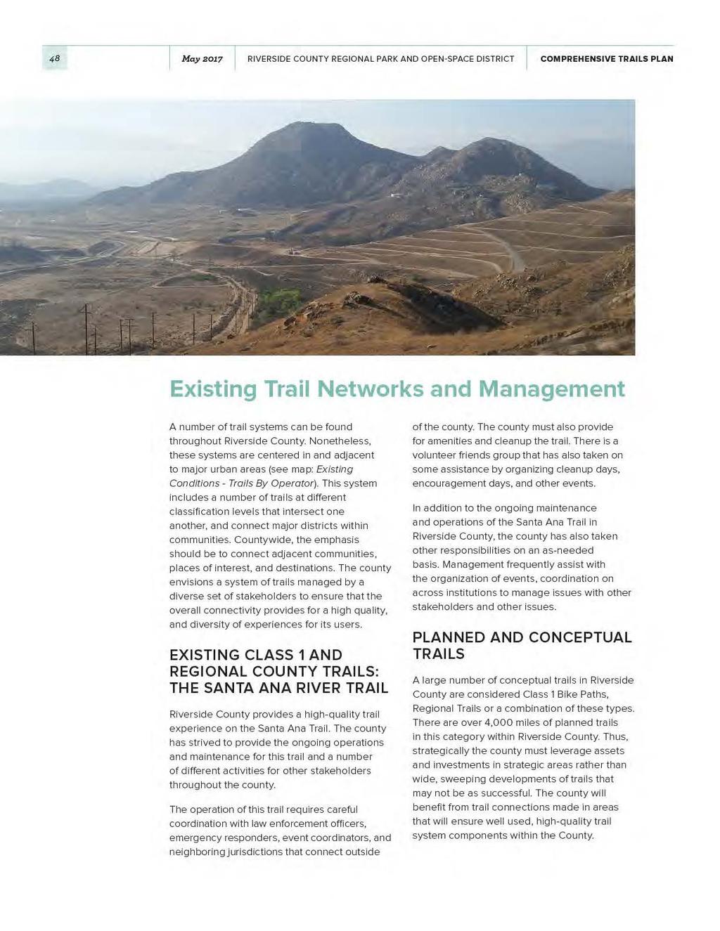
51 Chapter 3 EXISTING CONDITIONS 51 CONCEPTUAL, PLANNED OR EXISTING TRAILS IN RIVERSIDE COUNTY There are over 4,000 total miles of trails in various stages of development, ranging from concept to existing. These trails have been classified by type to provide an overall picture of how these future trail users will be able to explore the system.
52 52 May 2017 RIVERSIDE COUNTY REGIONAL PARK AND OPEN-SPACE DISTRICT COMPREHENSIVE TRAILS PLAN EXISTING REGIONAL TRAILS BY NAME Riverside County is home to many regional trails within and through the county. Some of these trails are historical in nature, in that they either provide historical context to an area, or have ground breaking innovations in planning efforts. This includes the Santa Ana Trail, detailed above. Coachella Valley Link (CV Link) The CV Link is a transportation alternative project created to encourage less vehicular use on Highway 111. This 50-mile trail project will provide for improved air quality, relieve traffic congestion, and provide $1.47 Billion in economic benefits to the area. The trail is innovative, in that it will allow for the use of low speed electric vehicles on a separated path adjacent to the constructed multi-use path. The trail will also utilize shade structures with solar panels, and provide Wi-Fi to connect users to the internet. The trail will also use Droughtresistant landscaping, public art, and provide for a number of spectacular views. Juan Batista de Anza National Historic Trail The Juan Bautista de Anza National Historic Trail commemorates the story of the Spanish Expedition. The trail is a 1,210-mile historic corridor and footpath that documents the travel of 30 families from modern southwest Arizona to upper California. The trail contains a rich history of various cultures and provides users with various types of trails throughout the corridor. Pacific Crest Trail Connecting the San Gorgonio Mountain Range to Mt. San Jacinto lies the natural surface Pacific Crest Trail (PCT). This trail aims to connect Mexico to Canada via California, Oregon and Washington. The trail brings users through pristine desert settings, old growth forest, and beautiful view sheds of the Cascade Mountain Range. The trail represents many of the most attractive areas in the Western United States. The trail is supported by a number of active volunteer groups, with some assistance provided on official trails by land managers who maintain the land in their tracts. The trail is approximately 2,650 miles in length. The southern segment of this trail also may be known as the California Riding and Hiking Trail. Victoria Avenue Bike Path The City of Riverside is home to the Victoria Avenue Bike Path. This six-mile-long path running a long Victoria Avenue is known for its palm trees that line the path, and meandering through some of Riverside s most notable neighborhoods. The path is listed on the National Register of Historic Places and connects multiple schools and neighborhoods, serving as a safe route to school. The path gives way to orange groves as it exits neighborhoods. Some on road connections are located on this path, but only for a short distance.
53
54 54 May 2017 RIVERSIDE COUNTY REGIONAL PARK AND OPEN-SPACE DISTRICT COMPREHENSIVE TRAILS PLAN Level 1 Destinations These destinations typically include, but are not limited to cities different from the user s place of origin, universities, major employers and major bikeways. Examples of other destinations may include significant landmarks, national parks or public lands, and others. Generally, people who are utilizing these destinations are willing to travel approximately ten miles to their end results. This mileage can sometimes substantially increase for recreational riders who aim to ride more miles to reach their destination. Some examples of these Class 1 Destinations in Riverside County are: Salton Sea State Recreational Area Joshua Tree National Park University of California, Riverside The Santa Ana River Trail The Coachella Valley Link Trail Box Springs Mountain Reserve Park Hidden Valley Nature Center Mount San Jacinto Lakes Matthews, Perris, Elsinore, Skinner, Hemet, and Diamond Valley Lakes Level 2 Destinations Level 2 destinations typically capture more riders who are interested in services, commuting, and other leisurely services. Types of destinations generally found in this classification includes downtowns, characteristic districts, transit stations, and regional parks or beaches. Users in these systems are typically willing to travel up to three miles to reach their destination, or connect to transit systems that will help them reach their final destination. Examples of this destination classification include: Lake Elsinore State Recreation Area Mount Rubidoux Downtown Riverside Palm Springs Art Museum Santana Regional Park Temecula Valley Wineries Level 3 Destinations These destinations include local landmarks that are easily accessible to multiple people of differing abilities. These places are typically within a mile riding distance. Examples include notable local destinations, schools, local parks, and trailheads. These destinations should give special consideration to the short term needs of cyclists, such as parking, rest areas, and amenities. These destinations have the potential to encourage higher ridership through the stimulation of demand for cycling safe places. Oftentimes, these destinations are clustered together in Urban Areas due to their distance from one place to another. Example destinations in the classification include: The Living Desert Zoo and Gardens Riverside Metropolitan Museum Numerous local parks in Western Riverside County

55 ÃÆ 138 EXISTING CONDITIONS - POPULATION DENSITY 395 Z 15 Z 40 Z 40 SAN BERNARDINO COUNTY RIVERSIDE COUNTY TRAILS MASTER PLAN 95 MOHAVE COUNTY ÃÆ95 POPULATION DENSITY People / Sq Mile People / Sq Mile People / Sq Mile People / Sq Mile People / Sq Mile ÃÆ30 Z 210 Z 215 ÃÆ66 ÃÆ62 ÃÆ62 ÃÆ71 Z 10 ÃÆ90 ÃÆ83 Z 15 ORANGE Z Z COUNTY ÃÆ74 NORCO CORONA RIVERSIDE JURUPA VALLEY Cleveland National Forest LAKE ELSINORE PERRIS Z 15 MORENO VALLEY MURRIETA SAN DIEGO COUNTY ÃÆ60 TEMECULA HEMET BANNING ÃÆ 371 ÃÆ 111 San Bernardino National Forest ÃÆ79 ÃÆ74 PALM SPRINGS Z 10 DESERT HOT SPRINGS PALM DESERT INDIAN WELLS INDIO COACHELLA ÃÆ 86S ÃÆ 195 ÃÆ86 Joshua Tree National Park ÃÆ 111 Salton Sea Z 10 Z 10 BLYTHE LA PAZ COUNTY MAP IN PROGRESS Pacific Ocean ÃÆ78 IMPERIAL COUNTY N ÃÆ78 MILES Z 5 Z 805 Z 8 ÃÆ94 Z 8 ÃÆ86 Z 8 YUMA COUNTY
56 56 May 2017 RIVERSIDE COUNTY REGIONAL PARK AND OPEN-SPACE DISTRICT COMPREHENSIVE TRAILS PLAN COUNTYWIDE CONSTRAINTS A number of conditions are present that enable the county to develop a world class trail system. However, these conditions are contrasted with a substantial amount of constraints that prohibit opportunities from becoming realized. These restraints can be classified as geographic and programmatic. Geographic Constraints Riverside County is the fourth largest county in California, and 26th largest in the Nation. This large size does not lend itself well to connecting communities with Regional or Class 1 Trails since maintenance of these facilities would incur substantial costs. Trails that span outside of areas where urban or suburban populations reside generally require managers to have larger budgets to consider transportation of equipment and personnel. Programmatic Constraints The County has also faced a lack of dedicated personnel to implement a fully functional countywide system. Personnel are vital to the ongoing cleanup of trails, maintenance of rest areas, facilities, and conditioning the trail surface. This personnel constraint has also been exacerbated by a funding constraint. Adequately funding a developing trail system is vital to the ongoing programming, staff, and improvements made to a trail. A system in development without a streamlined funding source, or numerous sources from individual organizations is likely to suffer in long term implementation phases Additionally, the County contains many different natural settings, including mountains, lakes, rolling hills and deserts. These wide geographic areas make as a great setting for the location of a regional trail, yet make for difficult operations and maintenance activities. Significant distances from population centers also places a burden on emergency services when attempting to respond to emergencies. Thus, many trails may be co-located with roadway projects.
57 Chapter 3 EXISTING CONDITIONS 57

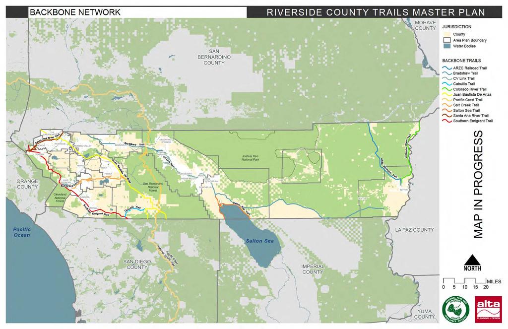
58 04 TRAIL PRIORITIZATION The goal of the backbone network is to provide a countywide network of of primary trails that connect to local trail networks in municipalities, parks, and public lands.
59
60 60 May 2017 RIVERSIDE COUNTY REGIONAL PARK AND OPEN-SPACE DISTRICT COMPREHENSIVE TRAILS PLAN Historically, the County has maintained an extensive (over 2,000 mile) planned trail network [insert general plan trails map]. This network included a mix of regional and local trails, both inside and outside the County s direct jurisdiction. A trail network that is this extensive is a best-case scenario, and the planning efforts that developed this network should not be discarded. Rather, a backbone network must be distilled from this more extensive plan, which lays achievable, concrete groundwork for a regional trail system. The current planning effort undertakes this reductive process, emphasizing trails previously classified as regional and/or historic, those existing as part of a previous plan or currently on-the-ground, those with long-distance connectivity, and those making connections to smaller-scale trail networks. Additional criteria used to evaluate backbone trails include: Population adjacency; Connection to destinations; Connection to other jurisdictions; Available right-of-way; Adjacent and underlying land-owners; Ability of the trail to close gaps in the regional network.
61
62 Chapter 4 TRAIL PRIORITIZATION This page intentionally left blank.
63

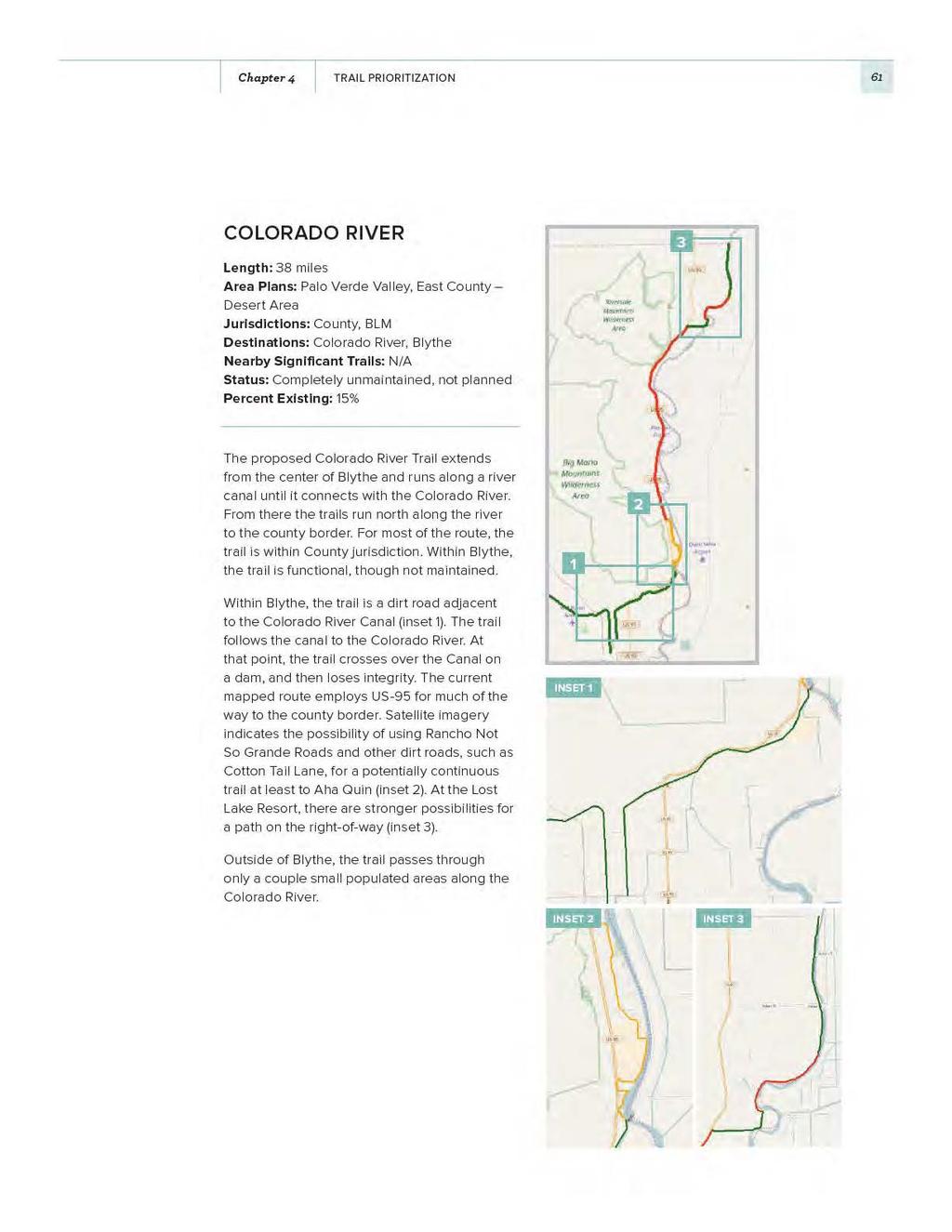
64 62 May 2017 RIVERSIDE COUNTY REGIONAL PARK AND OPEN-SPACE DISTRICT COMPREHENSIVE TRAILS PLAN ARZC RAILROAD Length: 38 miles Area Plans: Palo Verde Valley, East County Desert Area Jurisdictions: BLM, County Destinations: Blythe Nearby Significant Trails: N/A Status: Completely unmaintained, not planned Percent Existing: 100% Similar to the Colorado River Trail, the ARZC Trail begins in Blythe (on Lovekin Blvd) and runs north/south from Blythe to the north county border. On the northern edge of Blythe the route connects to the discontinued ARZC Rail Line. A dirt road runs adjacent to the rail line for the entire route. It appears functional as a trail, though it is not currently maintained. Outside of Blythe, the trail does not pass near any populated areas. For most of the route, the trail is within BLM land.
65
66
 Destinations: Coachella Valley Nearby Significant Trails: Vista Santa Rosa, Morongo Wash Status: Planned Percent Existing: 0% The proposed CV Link will be a 66 mile long Class I")
67 Chapter 4 TRAIL PRIORITIZATION 65 CV LINK Length: 66 miles Area Plans: Eastern Coachella Valley, Western Coachella Valley Jurisdictions: County, Cities (Indian Wells, Indio, Palm Springs, Palm Desert, Coachella) Destinations: Coachella Valley Nearby Significant Trails: Vista Santa Rosa, Morongo Wash Status: Planned Percent Existing: 0% The proposed CV Link will be a 66 mile long Class I (paved) path [CV Link.jpg]. It will operate primarily within urban areas, connecting to destinations in Palm Desert, Indio, and Palm Springs. Much of the route is within a dry creek bed.
, National Forest, State Park Destinations: San Bernardino National Forest, Anza-Borrego Desert State Park, Nearby Significant Trails: Juan Bautista")
68 66 May 2017 RIVERSIDE COUNTY REGIONAL PARK AND OPEN-SPACE DISTRICT COMPREHENSIVE TRAILS PLAN PACIFIC CREST NATIONAL SCENIC TRAIL Length: 82 miles Area Plans: Western Coachella Valley, REMAP Jurisdictions: County, BLM, Cities (Palm Springs), National Forest, State Park Destinations: San Bernardino National Forest, Anza-Borrego Desert State Park, Nearby Significant Trails: Juan Bautista De Anza Historic Trail, Mission Creek Trail, Little Morongo Canyon Trail Status: Completely Maintained Percent Existing: 100% The Pacific Crest National Scenic Trail is a continuous, maintained trail that runs north/ south near the center of Riverside County. Within Riverside County, it is primarily within the San Bernardino National Forest. It does not pass through populated areas. It intersects the Juan Bautista De Anza Historical Trail and Bradshaw Trail.

69 Chapter 4 TRAIL PRIORITIZATION 67 SALTON SEA Length: 32 miles Area Plans: Eastern Coachella Valley Jurisdictions: County, BLM, US Bureau of Reclamation Destinations: Salton Sea, Mecca, Bradshaw Trail Nearby Significant Trails: N/A Status: Not planned Percent Existing: 0% The Salton Sea Trail is a proposed trail running along the perimeter of the Salton Sea. As such, it connects to campgrounds and a number of small populated areas. The trail extends north from the Salton Sea to intersect with the Bradshaw Trail and CV Link. The land is a mix of Federal and County holdings, and is generally flat and undeveloped.

70 68 May 2017 RIVERSIDE COUNTY REGIONAL PARK AND OPEN-SPACE DISTRICT COMPREHENSIVE TRAILS PLAN CAHUILLA Length: 14 miles Area Plans: REMAP Jurisdictions: County Destinations: Nearby Significant Trails: Southern Emigrant Trail, Juan Bautista De Anza Historic Trail Status: Completely unmaintained, Not planned Percent Existing: 90% The Cahuilla Trail, located in southwest Riverside County, is a fairly complete east/west connection between the Southern Emigrant Trail and Juan Bautista De Anza Historic Trail [Cahuilla.jpg]. The western portion of the trail is generally narrow and hilly (ideal for hiking on foot), and not regularly maintained. It runs largely parallel to CA-371. The eastern portion of the trail runs directly east/west through farmlands. Within this portion, the route follows dirt roads (and there are numerous viable options). The trail is entirely on County land, in rural settings.
71
72
 Destinations: Corona, Murrieta, Lake Elsinore, Temecula, Cleveland National Forest, Salt Creek Trail Nearby Significant Trails: Temecula Wine Country, Santa Rosa")
73 Chapter 4 TRAIL PRIORITIZATION 71 SOUTHERN EMIGRANT TRAIL / BUTTERFIELD TRAIL Length: 69 miles Area Plans: Elsinore, Temescal Canyon, Southwest Area, REMAP Jurisdictions: County, Cities (Corona, Murrieta, Lake Elsinore, Temecula) Destinations: Corona, Murrieta, Lake Elsinore, Temecula, Cleveland National Forest, Salt Creek Trail Nearby Significant Trails: Temecula Wine Country, Santa Rosa Plateau Walking Trails, Santa Ana River Trail Status: Completely unmaintained, partially planned Percent Existing: 0.5% The Southern Emigrant Trail / Butterfield Trail are non-existent historical trails [butterfield. jpg]. Through Riverside County, both proposed trails generally follow the same alignment. The Butterfield Trail recently underwent a thorough planning process. The result is the most reasonable alignment for the planned trail. For most of the route, it is within populated areas, and largely follows existing roads. The southern end of the route is in County land, and the area around Lake Mathews is, as well.
 Destinations: Riverside, Corona Nearby Significant Trails: Southern Emigrant Trail, Juan Bautista De Anza")
74 72 May 2017 RIVERSIDE COUNTY REGIONAL PARK AND OPEN-SPACE DISTRICT COMPREHENSIVE TRAILS PLAN SANTA ANA RIVER TRAIL Length: 23 miles Area Plans: Cities of Riverside and Norco, Jurupa, Eastvale, Temescal Canyon Jurisdictions: County, Cities (Norco, Riverside, Corona, Jurupa Valley) Destinations: Riverside, Corona Nearby Significant Trails: Southern Emigrant Trail, Juan Bautista De Anza Historic Trail Status: Planned Percent Existing: 57% The Santa Ana River Trail is a partiallycompleted Class I Bike Path that runs adjacent to the Santa Ana River (on the south side) [Santa Ana Overview.jpg]. The trail follows an east/west alignment, is located in the northwest corner of the county, and connects to two proposed backbone trails: Southern Emigrant Trail and De Anza Trail. 13 miles of the trail have been completed [Santa Ana 01.jpg]. Segments of the unbuilt, western portion of the planned route utilize the nearby roads. There are also a few unmaintained dirt segments within the river area. When fully completed, the Santa Ana River Trail will be nearly 100 miles long, connecting from Huntington Beach to the San Gabriel Mountains.
75
76
77 Chapter 4 TRAIL PRIORITIZATION 75 This page intentionally left blank.
78
79

80 78 May 2017 RIVERSIDE COUNTY REGIONAL PARK AND OPEN-SPACE DISTRICT COMPREHENSIVE TRAILS PLAN SUMMARY OF TRAIL RELATED POLICIES AND CONSIDERATIONS The nature of trail development requires careful attention to detail and proactive efforts by stakeholders to ensure a high-quality trail system is ensured through policy. Trail policies should encourage private involvement in trail efforts, community stewardship of trails, ensure ease in managing the trail, and long term public support, with all of these goals aimed towards the implementation and encourages active transportation and recreation. Thus, a number of trail related policies have been identified as potential examples and best practices to provide guidance on updating the Riverside County Trails Master Plan. Accessibility Accessibility for trail ensures that access is provided for all trail users at a given location without compromising the integrity of the natural or human resources in an area. Access can mean multiple things, but generally means providing a facility for users who may have disabilities with access to the experience in a way that is meaningful to all users. Creating a truly accessible trail means thought is given to the construction, interpretational resources, and other components. Disabilities for trail users does not mean only mobility, but also auditory, visual, respiratory, and other impairments that could affect user experience. Advances in technology have spurred developments in accessibility policy, especially for the implementation of Other Power-Driven Mobility Device (OPDMD) policies, and providing trails with specific treatments where high populations of people living with disabilities may reside. More information is discussed in the best practices section, and other policies can also be found on the US Access Board website. In some instances, jurisdictions have adopted a policy to create trails that will serve as many users as possible, depending on the context, terrain, and other variables.


81 Chapter 6 POLICY RECOMMENDATIONS 79 Greenway Planning Riverside County contains countless, parks, conservation areas, protected areas and other greenspace which is an asset in greenway planning. Where appropriate, the county could plan new transportation passages using greenway concepts to connect these ecological corridors for wildlife and human movement. Land Use and Land Rights Acquisition Strategies Many agencies acquire land and all rights contained therein through fee simple land purchases. Fee simple acquisition refers to the outright purchase of the land and rights to the land by an entity. Oftentimes, many public agencies at the state and federal level often have recurring budgets which utilize this type of land acquisition strategy. Less than fee acquisition refers to the acquisition of land rights for a particular purpose. Generally, this is completed by public entities with a desire to either protect the land from development, or utilize the land for a given purpose. Government entities often acquire land rights for trails to help close small gaps within a trail system. Private sector entities who own utility, railroad or other corridors sometimes prefer less than fee acquisitions of trail projects. This is frequently referred to as purchasing an easement. Other acquisition strategies can include the option to ask the owner for right of first refusal wherein the landowner allows an entity to make an offer on the land without guaranteeing the right of sale. Developer contributions results in land undergoing development be required to be used in some way for trail, this can often be completed through zoning and development regulations (City of Monroe Parks and Recreation Dept., NC, 2015, pp ).
82 80 May 2017 RIVERSIDE COUNTY REGIONAL PARK AND OPEN-SPACE DISTRICT COMPREHENSIVE TRAILS PLAN Development and Transportation Regulations The development that occurs in previously undeveloped lands has the potential to include trails as a component of the development. Additionally, transportation projects should consider the context of the area and the addition of multi-use paths or sidepaths within the right-of-way to accommodate safe trail connections. Multiple jurisdictions throughout the country have gone about adopting this form of transportation and recreation project into area plans, ordinances and land uses, while some have instituted policies that encourage the consideration at various context. In Riverside County, the General Plan references numerous types and requirements for constructing trails in various elements of the plan. Trail Protection Ordinance Some counties have adopted protection ordinances to ensure the integrity and safety of the trail is ensures a safe recreational and transportation facility. These ordinances often provide for standards in the permitting, construction and maintenance of trail crossings, provides standards for review in permitting of areas adjacent to the trail, infractions for violators of the ordinance and other means to protect trail areas. Other county level trail protection ordinances identify specific trails and ecosystems for preservation and require a management plan to ensure native plant community protection. These ordinances are often served by trails, or bicycle and pedestrian citizen committees at the county, MPO, or a similar entity. Adjacent Landowner Trail Liability Programs and Policies Liability is an often-frequent concern of trail managers and other administrators. This frequently extends to property owners near trails, as fear of trespassing trail users who could be injured on private property could lead to litigation if the users somehow become lost. Some institutions have adopted programs or policies which encourage private individuals and organizations to become a partner in trail development. Programs adopted at state and county levels provide landowners who provide easements to trail developing organizations with liability protection in the instance that trail users are injured on adjoining or traversing private property owner s lands. Frequently, entities that own or manage lands will extend public liability insurance to private land owners to ensure protection for individuals or organizations that are willing to provide multimodal connections and close gaps in systems. These types of programs could be useful for areas with large landowning companies, such as timber companies, real estate developers on undeveloped tracts of land, or others. Rail-with-trail policy In areas where rail corridors are frequently abandoned or other opportunity corridors are present, it has become pertinent to adopt policies that would ensure that abandoned corridors are utilized for active transportation purposes in the future. These types of policies are commonly adopted for railroad corridors to ensure the integrity of the property for acquisition, and to ensure the stability of the property remains intact, but can also be applied to other linear corridors of similar nature such as utility or roadway corridors.


83 Chapter 6 POLICY RECOMMENDATIONS 81 Maintenance Maintenance of trails refers to the longterm well-being of the trail and its facilities. Generally, considerations of the trail and amenities life cycles are considered in the construction, but this also refers to inspection schedules to detect defective pieces in a system. This could be as simple as monitoring potentially hazardous situations on the trail as risk becomes more apparent to trail users, or generating repaving schedule as a paved trail s life cycle ends. Generally, maintenance is completed by trail managers or planners. Management Trail management relates to the ongoing efforts of an entity to ensure a safe, user friendly facility. This type element of trail implementation is an ongoing task from the outset of a trails inception. Trails require not only managers who will serve as the boots on the ground but also administrators who can perform managerial tasks behind the scenes. Consistent Management Practices In a survey of peer Trail Managers, many agencies discussed the various forms of trail management within the county. The operational framework for which departments and agencies operate give an understanding of how these institutions can better cooperate. The adoption of uniform planning standards from General Plans to Area Plans is one manner of consistent management and coordination. However, sometimes stakeholders must adopt more specific plans for various lands, or as needed to help resolve ongoing or potential conflicts between user groups.
84 82 May 2017 RIVERSIDE COUNTY REGIONAL PARK AND OPEN-SPACE DISTRICT COMPREHENSIVE TRAILS PLAN While not all agencies surveyed were in California, the results between the entities are informative. All agencies surveyed have completed at least one trail planning document. Nine out of ten agencies indicated they had a Park Master Plan, six indicated they had a Regional Park/Open Space District Master Plan, and five agencies indicated they had a Trail Master Plan. A full list of planning documents is found in the following. Table 5-1. Trail Agency Planning Documents DOCUMENT TYPE Park Master Plan 90% Regional Park/Open Space District Master Plan % OF RESPONDENTS 60% Trail Master Plan 50% Trail Maintenance Plan 30% Trail Use Survey Report 30% Bicycle Master Plan 20% Trail Operations Study 10% Trail Wayfinding Sign Plan 10% Trails Development Handbook 10% Stewardship Trails are meant to provide people with access to nature and places. These places are sometimes environmentally sensitive lands, creating the risk of exposure to damage ecosystems through overuse, pollution or other human factors. To remove this risk, managers should develop policies that encourage trail stewardship so that all users can enjoy the same experience and not disturb the ecosystem. Policies and programs can be implemented to protect lands and provide educational resources, frequently these are implemented with the assistance of friends or volunteer groups. (Tahoe Donner Association, 2013, pp. 1-3). Trail Type and Sharing the Trail Trail managers sometimes must balance the often-political decision of selecting the appropriate trail use or uses on a given piece of property. In an optimal setting, managers could selectively place trail uses in strategic locations to reduce user conflict and protect the environment, while creating a high-quality experience for all user types. This is rarely the case, and decisions made by trail administrators and managers can sometimes results in users feeling not represented in trail systems. Selecting where trails should be located is no easy tasks, but it must be done to reduce user conflict. The location of a trail or trail system will also help determine the appropriate uses. Trails located in environmentally sensitive lands should consider the environmental impacts of trail users for both environmental degradation and wildlife behavior. User Conflict and Etiquette User conflict reduction policies aim to ensure that conflict is mitigated before it raises to the point of being an issue between user groups or management. A number of policies and programs can be adopted to ensure that the risk of conflict can be reduced. These policies can be geared towards reducing conflicts between groups, provide education on appropriate use, and assist with self-regulation of trails. While policies geared towards reducing conflict can be put in place and signs implemented to the same effort, trails can often generate more demand than supply and this can frequently impact user experience (City of Des Moines, 2011, p. 192).

85 Chapter 6 POLICY RECOMMENDATIONS 83 Youth Engagement Youth are spending an increasing amount of time indoors. According to the National Parks and Recreation Association, children today spend less time outdoors than any other generation, devoting only four to seven minutes to unstructured outdoor play per day while spending an average of seven and a half hours in front of electronic media (National Parks and Recreation Association). The Nature Conservancy conducted a poll where respondents noted Lack of access to natural areas and discomfort with the outdoors are two primary factors (The Nature Conservancy). Riverside County is in an excellent position with the abundance of access to natural lands to make strides to re-engaging youth with the outdoors. Riverside County has over 60% ownership by the Federal Government, and even more land owned by Cities, Counties and private land endowments or trusts. Thus, programming could be implemented by various stakeholders and the County to ensure children have access to and become comfortable with playing in natural areas. Regional Trails Connectivity and Coordination Some entities around the country have opted to create a requirement that, where feasible, trails should create regional networks or paths that are intertwined with similar facilities. This type of network or regional connectivity would support regional networks, spur economic development along longer trails and provide more transportation and recreation options to users. Nonetheless, the creation of large scale trail networks requires the coordination of stakeholders and leadership by entities willing to invest financial and technical resources into envisioning the system. Typically, this happens at a regional level with support from many stakeholders.

86 84 May 2017 RIVERSIDE COUNTY REGIONAL PARK AND OPEN-SPACE DISTRICT COMPREHENSIVE TRAILS PLAN BEST PRACTICES IN TRAIL RELATIONSHIP TO THE PLAN In order to update the Riverside County Trails Master Plan, a number of best practices have been identified to provide guidance in the county s development of trail related policies. Best practices have been located in neighboring counties, states, and nationally. These recommendations build upon the previously discussed points and summaries of trail policies. The policies identified below should provide guidance on where to find trail policy that can be used as a tool to inform Riverside County in its effort to update their trail policy, and some model policies for consideration. A Case study has also been provided to provide clarity as to how these policies can be applied by managers to benefit trail users and communities. Accessibility The county should strive to create trails that area accessible to all users, regardless of abilities, considering environmental limitations. Accessibility policies generally provide information on what is an accessible trail, how to construct or design the appropriate trail in a given context, and what types of assistance devices are allowable on trails. There are a number of different policies to consider for mobility purposes, but other elements can be considered as a matter of creating a trail policy in relationship to accessible trails. Lancaster County, PA has adopted a trail accessibility policy that focuses on mobility, shown below: Access to trails and the use of devices as set forth below is limited to individuals with mobility disabilities and this policy does not authorize the use of these devices by others.lancaster County Park trails are available to individuals with a mobility disability as follows: Wheelchairs: Wheelchairs, as defined by 28 CFR , are permitted on all Lancaster County Park trails approved for pedestrian access. Other power-driven mobility devices (OPDMDs): OPDMDs, as defined by 28 CFR , are permitted on multi-use County Park rail trails including the Conewago Recreation Trail, the Lancaster Junction Recreation Trail, the Conestoga Greenway Trail and the Iron Horse Trail as follows:

87 Chapter 6 POLICY RECOMMENDATIONS The OPDMD must be electric-powered. Internal combustion engines are not permitted. 2. The OPDMD must have an electrical output of no more than 300 watts. 3. The OPDMD must be no more than 36 in width. Please note that electric bikes (ebikes) meeting the above criteria, and which allow the user to pedal or alternatively run on battery power, are permitted on all Lancaster County Park Trails approved for bicycle use. User discretion is advised as some approved bicycle trails may not be suitable for all types of ebikes. A. Users of a OPDMD or wheelchair must operate the device at a safe speed considering the condition of the trail and the other users traveling on the trail. B. The adoption of this Policy does not represent an endorsement that the Park trails or other Park properties are safe for the use of an OPDMD or wheelchair. Users must exercise reasonable caution and care while operating such devices within the Lancaster County Park System (American Trails, 2016). Boise, ID has also adopted a mobility policy for assistance devices that focuses on OPDMDs, while also going into detail on thes type of trail and the types of devices allowed. This policy also ensures staff are not allowed to ask about whether a person has or does not have a disability, or the nature of said disabilities (City of Boise Parks & Recreation Department Department, ID ). Greenway Planning Greenway planning can occur at the city, county, regional, state and national level. Countywide Master Plans should take into consideration the actions, plans and efforts of other stakeholders to ensure connectivity between greenways to benefit ecological and human systems. In Greenville, South Carolina the County implemented a plan to develop a broader framework for an interconnected system of pathways that will link together the various municipalities (Greenville County, South Carolina, 2010). This plan incorporated numerous implementation action steps to build upon existing greenways and policies for collaboration between institutions. Other areas have strived to create places with sensory assistance devices in areas with high potential for users with disabilities. For example, a number of stakeholders came together to create the Watertown Riverfront Park and Braille Trail Project. This project placed special emphasis on the use of sensory assistance devices such as braille and auditory assistance devices to ensure all users could effectively use the trail (Massachussetts EPA: Office of Energy and Environmental Affairs, 2016).
 If any portion of the lot proposed for residential development lies within an area designated on the officially adopted recreation master plan as a neighborhood park or part of the greenway")
88 86 May 2017 RIVERSIDE COUNTY REGIONAL PARK AND OPEN-SPACE DISTRICT COMPREHENSIVE TRAILS PLAN DEDICATION OF OPEN SPACE. (A) If any portion of the lot proposed for residential development lies within an area designated on the officially adopted recreation master plan as a neighborhood park or part of the greenway system or bikeway system, the area so designated (not exceeding 5% of the total lot area) shall be included as part of the area set aside to satisfy the requirement of Section 198. This area shall be dedicated to public use. (B) If more than 5% of a lot proposed for residential development lies within an area designated as provided in Land Use and Land Rights Acquisition Policies The discussion of acquisition policies above provided an overview of some of the strategies utilized by trail development organizations throughout the country from a broad point of view, other key considerations and specific policies are provided below. The Town of Williston, Vermont has implemented an acquisition policy that encourages the donation or purchase of land through many different processes. The policy enables the government to require developers to donate land where trails have been identified in planning documents, accept easements on behalf of the city, and other methods (City of Williston, VT., 1998). Monroe, North Carolina requires that residential developments contained within a recreational master plan dedicate a certain percentage of land to the development of the trail network (City of Monroe, NC, 2003). A developer would often be required to dedicate open space, or it can be acquired through other means. The text of this ordinance is as follows: Subsection (A), the city may attempt to acquire the additional land in the following manner: (1) The developer may be encouraged to resort to the procedures authorized in Section and and to dedicate the common open space thereby created; or (2) The city may purchase or condemn the land. (Ord. O , passed ) Florida Statutes provides for the guidance of the State of Florida s Greenways and Trails Acquisition Program. This program utilizes many different tools that are capable of being applied to county level policies that are useful in program development of an acquisition program (The Florida Legislature, 2010). This program is discussed more in depth in the case study shown below. Development Regulations and Transportation Policies Throughout the country more trails have been constructed using policy and development approaches. These means to create paths typically have required close collaboration with developers and larger trail master plans, and between stakeholders to ensure policies are applied appropriately.
89 Chapter 6 POLICY RECOMMENDATIONS 87 The Riverside County General Plan already ensures that trails will be considered in area plans. The Circulation, Open Space, and Healthy Communities Elements of this plan all consider the relevant policies in relationship to trails, bikeways and sidewalks. Still, consideration should be given to more staunch language and goals related to new development within the County should be considered. An example policy from Valley County, Idaho Pathways Concept Master Plan states: Goal 3. The Valley County Planning and Zoning Department should require individuals and developers who propose new developments and subdivisions to blend their proposals into the vision for a valley-wide pathways system (Valley County Pathways Committee, 2015). Additional language could be directly related to the development of specific trails and systems. This gives developers a clear sense of what benefits they could also market to new home or commercial business owners as development occurs. This approach was utilized in the Guadalupe River Trail in San Jose, California. In this project, numerous funding sources, including developer s fees and redevelopment funds were used to construct a new trail along this waterway (Rails to Trails Conservancy). Other innovative transportation projects have also begun to be designed and constructed in the County. This includes the Coachella Valley Link, which is utilizing a mixture of funding to develop over 50 miles of shared transportation systems, including those for transit, biking, walking, and low speed electric vehicles. As additional funding or maintenance needs arise, the CV Link could take up funding from other, private sources to fill in gaps. The identification of high priority trail projects with in Riverside County could also help to direct resources towards specific improvements. Priority trail projects would be identified in area plans and have greater potential to have fees tied to their development, attributable funding sources, and protection ordinances to guarantee their perpetuity. Trail Protection Ordinance In some areas, county governments have instituted protection ordinances for trails to ensure that new development or communities do not encroach or damage a trail. This has created both institutional capacity to respond to issues with existing trail and for community based review teams to ensure that trails are considered in new developments and crossings. Seminole County, FL passed an ordinance in 2002 reflecting such a policy (Seminole County, FL, 2002). Indian River County, FL has also established a protection ordinance specifically for the protection of one trail, and the habitat that has formed the trail (Indian River County, FL, 1990). Riverside County is home to a number of historic trails located throughout the County. These historic routes enrich the cultural experience of visitors and residents in the County. The County could consider the development of protection ordinances that guarantee the long-term feasibility of safe, removed paths from roadways and encourage interpretational opportunities are utilized in local jurisdictions. Additionally, this would provide assurances that changes at various levels of governance won t affect trail projects without significant alternative evaluation. Since many of these historic trails are not exact, buffer zones would need to be created to ensure that multiple routes could be used as part of the system. Trails would serve as one of the major components and have driving routes tied to the system. This would also provide a means to ensuring that funds typically used for commuters could contribute to trail systems. This type of system in Riverside County could also help to prioritize historical route development and guide trail resources towards routes that would benefit multiple user groups.
90 88 May 2017 RIVERSIDE COUNTY REGIONAL PARK AND OPEN-SPACE DISTRICT COMPREHENSIVE TRAILS PLAN Adjacent Landowner Trail Liability Programs and Policies Numerous counties and states have adopted policies which provide relief to landowners who are adjacent to public lands or trails, or allow the use of their land to connect public lands without the use of an easement. This often provides landowners who would typically be averse to trails developing in their area with peace of mind when new trails are being studied or examined for development. San Diego County, CA, has an implementation strategy geared towards encouraging private landowner involvement in the development of local and regional trail systems. This is found in the following implementation policy (San Diego County, CA): Rail-with-Trail Policy In Mendocino County, CA the government has put in place a policy regarding the abandonment of rail corridors that could be converted to other uses. This policy is applicable and reflected in many ways around the country with through other policies and has been provided if the opportunity for rails to trails are high within the area. Policy DE-159: Preserve abandoned railroad rightof-way for trail use and investigate the feasibility of collocating bicycle paths on unused portions of existing rights-of-way (Mendocino Council of Governments, 2012). Countywide Implementation Strategy 3.2: Continue to provide indemnity (as currently provided by County Code Section ) to persons granting trail easements and landowners adjacent to trails in order to encourage voluntary dedications and landowner support for efforts to implement regional and community trails Washington established a marine program similar to those throughout the country that encourages private landowners to open their lands to public use while removing liability from the property owners. This is established in state law and implemented by various agencies (Washington State Legislature, 1967). The Florida Greenways and Trails Designation Program also provides for protections of landowners who are adjacent to public property that allow trail users to utilize their private property. This program is created under Florida Statutes (The Florida Legislature, 2010). This program is also discussed in the case study below.

.")
91 Chapter 6 POLICY RECOMMENDATIONS 89 Maintenance A well-developed maintenance plan and schedule stems from a policy that places a higher level of importance on the necessity to consider the long-term sustainability facilities. Maintenance policies should be considered with management policies, as these policies generally influence one another, yet have a different implementation role depending on agency classifications. The Tahoe Donnor Trails Master Plan provides an excellent example of maintenance and management policies (Tahoe Donner Association, 2013, pp. 1-2). Tahoe Donner Trails Master Plan: Goal 4: Maintenance. Provide for standardization of trail system maintenance. Policy 4.1: Asset Preservation. Tahoe Donner will strive to maintain the trail system, ancillary structures, and the surrounding recreation space for sustainability. Policy 4.2: Regular Maintenance. This Plan will serve as strategic guidance for the standard and type of maintenance to occur on the trail system. Policy 4.3: Inspection. Regular systematic inspections of the trail system will occur to prevent and mitigate degradation of use, minimize hazards and risk, and promote general trail activity and feedback through trail presence by staff and the membership. Management A strong trail policy will enable those responsible for the day to day oversight of the trail to enforce rules, policies and regulations related to the trail. Many different jurisdictions have enacted strong overall trail policies. Examples policies of these plans in relationship to trail type, etiquette and stewardship can be found below. A notable example of policy planning for trails and management comes from the Tahoe Donner Trails Master Plan. This plan outlines policies for the jurisdiction to follow and provides guidance for future management and trail implementation strategies (Tahoe Donner Association, 2013, pp. 1-2). Tahoe Donner Trails Master Plan: Goal 1: Management. Establish management practices and protocol for a comprehensive trail system utilized by a diverse population. Policy 1.1: Benefit and Opportunities. The trail system in Tahoe Donner will be managed to benefit the community and provide a variety of recreational opportunities for all user types. Policy 1.2: Multi-Use Trail System. Tahoe Donner will provide a system of trails to accommodate a variety of users including hikers, joggers, bicyclists, equestrians, cross country skiers, snowshoers, and dog owners.
92 90 May 2017 RIVERSIDE COUNTY REGIONAL PARK AND OPEN-SPACE DISTRICT COMPREHENSIVE TRAILS PLAN Policy 1.3: Trail System Rules. Management will work to establish and communicate trail system rules to reduce user conflict, effectively manage risk, and improve user experience. Policy 1.4: User Conflict. Management will work to reduce user conflict through trail design and maintenance, as well as working with users to establish and promote communication for trail sharing. Policy 1.5: Stewardship. Management of the trail system will make every effort to sustain the trail system and the surrounding environment through sound management practices and community involvement. Policy 1.6: Resource Conservation. Tahoe Donner will strive to practice resource conservation through its trail system, future development, and programs established for the trail system. Policy 1.7: Communication. Tahoe Donner will effectively communicate this Plan, projects and programs, and welcome user feedback. Additional trail policies contained within this document can contribute to the overall cohesiveness of the trail system locally. These policies generally fall under the categories of Planning and Development. Policy 2.3: Trail Type. The trail system should include multi-use and user-preferred trails of varying levels of difficulty and provide the opportunity to connect to other trail systems which may offer more trail class types. Policy 3.5: Project Management Best Practices. Every effort will be made to plan, implement, and execute each project thoroughly. Consistent Management In Florida, the State Park System has streamlined the management process to be consistent across the 250-mile trail system between nine state trails. This process is consistently laid out in statute at the state level, and also in rules at the agency level to ensure consistency between different ecological zones in the various areas of the state. Implementing a uniform process for managing trails would enable Riverside County to save in planning costs, but may inhibit creativity in the development of more specific plans for the area. Consideration should be given to the overall need for planning in each area, for each major trail corridor, and how much level of detail will be required to create a high-quality experience. Ensuring high value in the system is a key means to making the system s use a normal activity for residents and attractive amenity for tourists. Youth Engagement Riverside County has a number of means to approach engaging youth in outdoor recreation, especially via trails. Partnerships should be created between landholding agencies and not for profits to ensure that youth have equitable access to lands. Programming between partnerships can take the form of maintaining natural lands and trails, hikes and camping events, interpretive seminars in strategic urban areas and places of interest, and many other means.

93 Chapter 6 POLICY RECOMMENDATIONS 91 Regional Trails Connectivity and Coordination Generally, trails that are interconnected with similar facilities support multiple objectives of county policies. In San Diego County, CA an implementation strategy has been set to guide future trail development. These policies are important to the development of trail network systems and creating a network of recreation and transportation facilities. Countywide Policy 2.3: Participate in completing missing segments of regional trails to satisfy the need for long range trail opportunities (San Diego County, CA, p. 133). Due to the size of Riverside County, the need for specific planning efforts should occur between area plans, specific plans and other plans that have the potential to align corridors and create new trails. This has the potential to increase the number of trails in areas that may be deprived of recreational or transportation facilities. Additionally, requiring that coordination occur during planning updates ensures continued collaboration between County and Sub-County level stakeholders. Policy 8.52 Trail coordination. Coordinate planning, design, improvement, and maintenance of the trail system among City agencies, other public agencies, non-governmental partners, and adjacent landowners (City of Portland, Oregon, 2015). This policy also contains similar language for creating a diverse, publicly accessible, and ecologically friendly system of trails that have numerous other social, environmental and cultural benefits. Other entities that have created trail coordination policies, institutionalized coordination within their plans or instituted coordination projects include many counties and state agencies within the state. Most notably, the National Park Service created the Santa Monica Mountains Area Recreation Trails, which is a process for improving and enhancing coordination between stakeholders in the area (National Park Service, 1997). This plan is undergoing an update, initiated in Policies related to developing trails as components of local transportation systems and as contributors to the recreation system are located throughout the Country in various forms. In Portland, Oregon, the City has taken up numerous policies that require the coordination of trail efforts with stakeholders.
94 92 May 2017 RIVERSIDE COUNTY REGIONAL PARK AND OPEN-SPACE DISTRICT COMPREHENSIVE TRAILS PLAN CASE STUDY: The Marjorie Harris Carr Cross Florida Greenway Visionaries in the state of Florida once thought that creating a barge canal across the Floridian Peninsula would substantially cut down on shipping time for ships that would cross the newly constructed Panama Canal. While this project was underway in the early 1900 s, dredging and property acquisition alike were ongoing to push the project forward. Meanwhile a number of groups eventually fought and won to stop the project. The federal government now owned an approximate 110-mile-long property spanning from Inverness on the west coast of Florida, to Ocala and almost to the St. Johns River. The property spans about a mile wide in some areas. The federal government decided to turn the land over to the state to become the largest state park in Florida. Being a sizeable unit to manage and a highly contentious history, numerous recreational groups began vying for the property s potentially lucrative trail real estate and numerous user conflicts ensued. The management of the property and trail users eventually underwent a collaborative process in 2004 to reduce conflicts between property owners and users (Carr, 2004). Some established and indirect policies instituted on behalf of the managers and administrational institutions responsible for this greenway project are directly related to positive outcomes and conflict reduction between stakeholder groups. These policies could be considered best practices, as similar policies or practices have also been identified at similar levels of governance in different jurisdictions or areas. Land acquisition and private landowner protection policies and programs The State of Florida has a dedicated source of funding for the development of a Statewide Greenways and Trails Program. This program can utilize tax funds passed through ballot initiatives by the citizens to purchase lands through fee simple acquisitions or various easements (less than fee). Additionally, these programs are eligible to receive lands as private donations (The Florida Legislature, 2010). Additionally, landowners who do not wish to turnover their land or rights to land can have their lands designated into the statewide program to enable users to pass through small trail connections. The program extends the State of Florida s Liability Protection to landowners who designate their properties as part of the state system (The Florida Legislature, 2010). Separated Trail Uses Initially, trails were developed in this area and maintained by both park and trail service staff, and volunteers. Overtime, these groups began to take ownership of trails in the area and demand exclusionary uses of certain areas. Overtime, conflicts between user groups became apparent and required managerial action on behalf of the park service to relieve tensions. Management and administrative staff took steps to both separate trail uses and create shared use trails in areas where lands are suitable for the use type. Generally, equestrian trails are located in the southern part of the property, bicycles on the northern and hiking or shared use trails located in the center of the property. A map of the property has been attached for illustration on the last page of this document. Encouragement programs The Cross Florida Greenway is the location of many events hosted by internationally oriented trail groups, and local encouragement groups who promote active living. One example of this is weekly groups hosted by local bicycle clubs that encourage youth to ride on the many BMX, mountain bike, or shared use paths located on the property. This is held through weekly events hosted by clubs, or larger events sponsored by many organizations, such as Take a Kid Mountain Biking Day (Ocala Mountain Bike Association).
95 Chapter 6 POLICY RECOMMENDATIONS 93 BIBLIOGRAPHY OF TRAIL RESOURCES This section provides information on the areas, policies, and programs that have been utilized throughout this memo. More information is available within each resource regarding policy and regulatory development. American Trails. (2016). Resources and Library: Accessible Trails. Retrieved from Lancaster County Parks Department (PA) ADA Trail Accessibility Policy. Carr, S. L. (2004, February 24). Greenway concerns discussed at meeting. Ocala Star Banner, pp. news/ /greenway-concerns-discussedat-meeting. Retrieved from com/news/ /greenway-concernsdiscussed-at-meeting City of Boise Parks & Recreation Department Department, ID. (2016). OTHER POWER DRIVEN MOBILITY DEVICES POLICY. Retrieved from OTHER POWER DRIVEN MOBILITY DEVICES POLICY : org/media/227335/other-power-driven-mobilitydevices.pdf City of Des Moines. (2011, June). City of Des Moines, IW. Retrieved from Des Moines Trails: PDF/Bicycleandtrailsmasterplan.pdf City of Monroe Parks and Recreation Dept., NC. (2015, June). Greenways Master Plan. Retrieved from Greenways Master Plan: monroenc.org/wp-content/uploads/monroe- Greenway-Master-Plan_FINAL.pdf City of Monroe, NC. (2003, December 16). American Legal Publishing Corporation. Retrieved from Adopted Ordinances: library.amlegal.com/nxt/gateway.dll/ North%20Carolina/monroe/titlexvlandusage/ chapter156zoningcode?f=templates$fn=default. htm$3.0$vid=amlegal:monroe_ nc$anc=jd_ City of Portland, Oregon. (2015, August). City of Portland: Bureau of Planning and Sustainability. Retrieved from Chapter 8: Public Services and Facilities: article/ City of Williston, VT. (1998, December 10). Greenway Acquisition Policy. Retrieved from Greenway Acquisition Policy: williston.vt.us/vertical/sites/%7bf506b13c- 605B E5927E49F0%7D/ uploads/%7b4e3db9a2-f586-42e2-a cca668%7d.pdf Greenville County, South Carolina. (2010). Comprehensive Greenway Plan. Retrieved from Greenways-Master-Plan-Combined.pdf Indian River County, FL. (1990, November 11). Indian River County, FL (Municode). Retrieved from Indian River County, FL (Municode): library/fl/indian_river_county/codes/code_of_ ordinances?nodeid=coor_titixladere_ CH929UPHAPR_S929.12JUTRPRARVEPR Massachussetts EPA: Office of Energy and Environmental Affairs. (2016, November). Watertown Riverfront Park and Braille Trail Project. Retrieved from Watertown Riverfront Park and Braille Trail Project: gov/eea/agencies/dcr/conservation/planningand-resource-protection/projects/watertownriverfront-park-and-braille-trail-project.html Mendocino Council of Governments. (2012, May). American Trails: Mendocino County Railwith-Trail Plan. Retrieved from American Trails: Mendocino County Rail-with-Trail Plan: atfiles.org/files/pdf/mendocino-county-railwith-trail-plan.pdf
96 94 May 2017 RIVERSIDE COUNTY REGIONAL PARK AND OPEN-SPACE DISTRICT COMPREHENSIVE TRAILS PLAN National Park Service. (1997, September). SMMNRA Interagency Trail Management Plan. Retrieved from Santa Monica Mountains Area Recreational Trail Coordination Project: smmartreportsept1997.htm Ocala Mountain Bike Association. (No Date). Take a Kid Mountain Biking Day. Retrieved from Take a Kid Mountain Biking Day: org/docs/2016_tkmbd.pdf Rails to Trails Conservancy. (No Date). Community Built: Stories of Volunteers Creating and Caring for their Trails. Retrieved from ashx?id=2997 San Diego County, CA. (No Date). Community Trails Master Plan. Retrieved from Trails Program Management: gov/content/dam/sdc/pds/ctmp/ ProgramManagement.pdf Tahoe Donner Association. (2013). Tahoe Donner Trails Master Plan. Tahoe: Tahoe Donner Association. Retrieved from wordpress/wp-content/uploads/2012/03/ TRAILS-MASTER-PLAN-2013.FINAL_.pdf The Florida Legislature. (2010). The 2012 Florida Statutes ( ). Retrieved from The Florida Legislature: fl.us/statutes/index.cfm?app_mode=display_ Statute&Search_String=&URL= /0260/ Sections/ html Valley County Pathways Committee. (2015, August 15). Valley County Pathways Concept and Master Plan. Retrieved from cityofdonnelly.org/pathwaysmasterplan.pdf Washington State Legislature. (1967). Washington State Legislature. Retrieved from RCW : aspx?cite= Seminole County, FL. (2002). Seminole County (Municode), FL. Retrieved from Seminole County (Municode), FL: com/library/fl/seminole_county/codes/ code_of_ordinances?nodeid=ch190pare_ PT5SECOTRPR

97
98
99
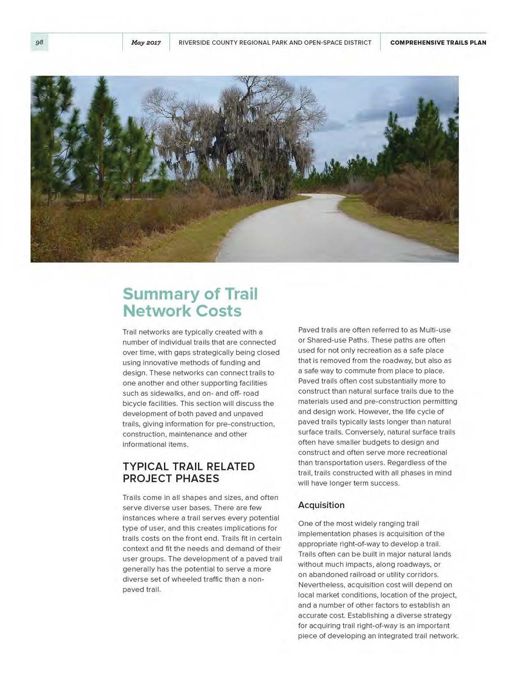
100
101 Chapter 7 FUNDING 99 Feasibility Study A feasibility study in for trails often aims to find the most feasible alignment for a trail, and identify the obstacles to developing a preferred alignment. This type of study often considers multiple alignments for a potential trail route, environmental and social considerations, rightof-way availability and cost considerations. This part of the study often sets the expectations for other phases of trail development, maintenance, and how the trail has the potential to impact the communities it touches. Economic studies often are considered in feasibility studies as a means to determine economic impacts of the trail. Feasibility studies for natural surface trails are less intensive than paved trails in discovering available right-of-way due to their usual location in natural areas with significant space availability, and other considerations. Nevertheless, environmental impacts should be considered in this phase, with the inclusion of biologist and other relevant personnel. ADD PHOTO Feasibility Study Cost Feasibility studies are often the most cost efficient means of identifying a trail alignment and ensuring feasibility in accomplishing trail construction. Depending on the nature of a feasibility study, costs could vary widely for this phase. One project of this type with an identified cost is the Doodle Rail Trail Feasibility Study and others that are similar in scope to provide an understanding of how much this element costs nationwide. The cost for the Doodle Trail Feasibility Study was $40,000 for a 7.5-mile rail-to-trail project (Sanders, 2016). Permitting and Design Every trail should have professional design incorporated into its development to ensure the longevity of the plan and safety in the ultimate build out for users. The type of trail design and complexity of a project will influence the project cost, namely the location of the trail, surface type, and environmental considerations. Organizations have become more able to lend their assistance to create natural surface trails, such as the International Mountain Bike Association, and American Hiking Society or equestrian groups. Natural surface trails often can be designed with much less costs than paved trails, due to the requirements placed on paved trails to enhance safety and standards. Trail permitting is often considered a component in many components of trail design. Sometimes environmental engineers or landscape architects are able to effectively consider impacts on the environment and complete the permitting process. This can be an intensive administrative task depending on the context of the trail. Local trails that are smaller in length and have minimal environmental and social impacts generally can go through permitting processes faster than longer paths, or those which traverse areas which would trigger greater levels of permitting. For example, a rail-with-trail project that resides on already disturbed land and is located entirely on city owned land would likely have less permitting than a trail traversing national park lands with wetlands impacts, or one where right-of-way needs to be acquired. Due to the varying cost of design and permitting from project to project, cost estimates have not been provided. Variables that typically affect design and permitting are ecologically or historically sensitive areas, bridges, typographically variable terrain, and other elements. ADD PHOTO Construction Trail construction often is one of the more expensive phases in trail development. Construction cost can range widely depending on the context and required elements to build a complete trail. Considerations should be given to if bridges or tunnels are needed,
102 100 May 2017 RIVERSIDE COUNTY REGIONAL PARK AND OPEN-SPACE DISTRICT COMPREHENSIVE TRAILS PLAN mitigation for trails in or near sensitive ecosystems, crossings, or elements of welldeveloped trails, such as trailheads, rest stops and interpretive materials or signs. Table 7-1 provides insight into the wide-ranging costs of trail construction, depending on classification and location. Maintenance Table 7-1. Cost estimates for trail construction on a per-mile basis. PROJECT NAME COST PER MILE NOTES Doodle Rail Trail $283,000 Project located in South Carolina and connects Cities of Easley and Pickens. Florida Park Service, Office of Greenways and Trails Milwaukee County, Wisconsin Trail Construction Cost Estimates $500,000 Statewide System consisting of multiple projects with different implementation agencies $149,000 - $301,000 Milwaukee County Trails Network Plan, 2007 City of Redlands Class I Bike path $800,000 Paving, Striping and Signage City of Redlands Class II and III Bikeways $35,000 Striping and Signage Notes: Costs per mile are estimated and based off of best information available at time of writing. Sources for each table available in document Bibliography. In developing a trail system, ongoing maintenance must be considered to ensure the full life cycle of the facility and enjoyment by users. Maintenance cost for trail facilities depends on the trail type, user-features, context and setting of the trail, and community support. These tenets make the development of a cost estimate for a trail system difficult, yet some examples provide with general understanding of trail maintenance costs. Estimating cost for long term maintenance for rail-trails is difficult due to a lack of data and monitoring. Rails to Trails Conservancy (Rails-to-Trails Conservancy, 2015). More information is provided below on other trail projects that have been collected from around the nation to provide context to the amount necessary to manage trails. These cost estimates are provided on a per-mile basis. The context and amenities on each trail will vastly impact the cost of trail maintenance. ATTACHMENT 1: Trail Agency Management Practices provides more information and resources on the cost of trails, while Table 2 provides specific information on trail maintenance.

103

104 102 May 2017 RIVERSIDE COUNTY REGIONAL PARK AND OPEN-SPACE DISTRICT COMPREHENSIVE TRAILS PLAN Recommended Strategies for Trail Development This section discusses the types of funding strategies available to the county. To complement this research study, a survey of peer agency best practices was conducted to better understand trail management practices. One of this surveys components was to better understand funding. The results of this survey can be found in ATTACHMENT 1: Trail Agency Management Practices. In this survey, many institutions responded that funding sources for trails generally originate through the federal government and are distributed through competitive grant programs. SHORT TERM FUNDING Short term funding strategies typically occur within a narrow timeframe, such as one to three years for trail projects. In targeting funding resources for trail projects, managers should generally prioritize discretionary or competitive grant programs. However, these funds are distributed nationwide and sometimes only result in marginal gains on an annual basis. Other successful funding pursuits in the near term, could come from a diverse set of funding available from not-for-profits, local government funds, and others. Because of the limited timeframe associated with most funding resources, each funding resource may be in a state of flux and requires attention to ensure opportunities are not missed. To complement these grant and other assistance programs, numerous local and state funding resources have been identified as potential trail development resources. At the county and municipal level, municipal bonding, sales taxes, general funds, and fee programs are common sources for sustained and dedicated trails funding. While there are substantial capital sources available at the Federal, State and Local level, trail managers often cite the need for dedicated federal and state funding for trail maintenance (Rails-to-Trails Conservancy, 2015). Of the ten respondents to the Survey in attachment 1, six indicated a developer impact fee program was in place. Three of the six respondents had the option to utilize those funds for construction, but none of the respondents indicated these fees could be used for maintenance once the trail is built.
105 Chapter 7 FUNDING 103 Grant Programs There are a number of programs throughout the nation which provide discretionary and competitive grants for projects. There are also many not-for-profit organizations that provide grants for capital improvement and maintenance. These resources often require an in-kind donation of capital or in kind labor as part of the project, if selected for funding. Grant programs are mostly funded through the federal government, but passed through to states and other organizations to administer, such as state Departments of Transportation. In the short term, these grants are generally available to applicants on an annual, recurring basis. Thus, trail development organizations are able to capitalize on funding sources and submit more competitive applications. Attachment 1 discusses a number of these grant funding resources, and generally denotes that a majority of the resources are either not available for maintenance activities or generally not constitute competitive enough applications to compete with other grant applications. Additional information on California specific grants are provided below. California Department of Parks and Recreation: This department oversees a number of grant programs directly relevant for Riverside County to consider as potential funding resources. The Office of Grants and Local Services (OGALS) manages a number of grants for consideration in the short term (California Department of Parks and Recreation, No Date).» The Recreational Trails Program (RTP): This national program, managed by the aforementioned office is a national program providing funding to a variety of trail projects, and in various phases. This program is an annual funding source that should be frequently utilized to develop trails.» Land and Water Conservation Fund: Similar to the RTP program, this federal program that is managed by the state provides annual funding to projects that aim to implement projects. This is also an annual program and should be utilized in a tool box of funding resources to implement projects.» Habitat Conservation Fund: This fund is more geared towards habitat conservation, but can still be used towards conservation projects that have trail elements. California Department of Transportation(CALTRANS): There are numerous programs that are under the Active Transportation Program (ATP). This program combines state and federal funding sources under the jurisdiction of the Office of Active Transportation and Special Programs. While this program is not directly geared towards recreation, it s goals are similar to those of recreational programs, in that it aims to provide more transportation options in a non-automotive manner. There are a number of programs overseen by this office, including the State Safe Routes to Schools Program, Bicycle Transportation Account, and Transportation Alternatives Program (California Department of Transportation (CALTRANS), 2016).
106
107 Chapter 7 FUNDING 105 Capital Improvement Funds (CIF) CIPs are a short term budgetary process where local jurisdictions identify and prioritize projects. Generally, these plans are geared towards infrastructure improvements rather than maintenance. These plans aim to identify and collate the projects over the next few years. Other Tax Funds A series of tax funds can be implemented locally to ensure funding for trail projects. This includes sales taxes, income taxes, property taxes, and others. These taxes must often be approved by a referendum, board, commission or state ballot depending on the nature and type of taxation. Some regional organizations base their operations off of taxes, such as the Community Service Districts. While there are substantial capital sources available at the Federal, State and Local level, trail managers often cite the need for dedicated federal and state funding for trail maintenance (Rails-to-Trails Conservancy, 2015). Of the ten respondents to the Survey in attachment 1, six indicated a developer impact fee program was in place. Three of the six respondents had the option to utilize those funds for construction, but none of the respondents indicated these fees could be used for maintenance once the trail is built. Many strategies are used throughout the country to secure funding, the next two sections of this memo will address long and short term strategies for securing funding. LONG TERM STRATEGIES In developing a long-term plan for funding trail network development, many considerations should be made for contingency planning; who will be the implementing and maintaining agency, and where will additional funding come from down the road in case of needed capital? These are important questions and are susceptible to change over time. Trail Master Plan In the long term, a locally credible trail implementation entity should execute a planning process with the assistance of local stakeholders to define their trail network vision. This vision within a master plan or trail implementation plan ensures that the existing conditions, and desired future conditions align not just with the expectations of the community, but also the realities within a given timeframe. Trail master plans should contain an implementation component that describes the remaining phases of trail implementation, expected cost of each phase, including annual maintenance costs, and a targeted funding source for such improvements. Without this vital implementation component, many organizations are left wondering where resources should be prioritized, how funding will be acquired, and who the lead agency will be to develop the trail.
108 106 May 2017 RIVERSIDE COUNTY REGIONAL PARK AND OPEN-SPACE DISTRICT COMPREHENSIVE TRAILS PLAN Parks and Trail Management Plans Many organizations who manage large units of parks or trails have adopted management plans. These plans vary in timeframes and size, but generally are at set at five to twenty years timeframes and for trails that transect jurisdictional boundaries, and parks with diverse needs. Management plans often have a number of elements that help to guide how management entities respond to certain needs. Plans are written to understand the current needs of the managed unit from an ecosystem and human systems which are connected by the unit. These plans also identify future needs of the unit, including aging infrastructure that will require capital for repair. Local Funding Sources and Tools In addition to the short-term funding resources available for trails, long term solutions are also available to local implementing jurisdictions. Impact Fee Program An impact fee program is meant to cover the cost of development and the impacts it has on public services impacted by it. Impact programs are developed only in relationship to new developments and a number in the west have been identified as an allowable source of funding for trail capital projects. In some instances, the trail must be within a locally adopted transportation improvement, such as a sidewalk. Municipal Bonds Municipal Bonds are loans that governments borrow to pay for capital projects over a given period of time. Because of how these debts are incurred, they are typically not able to be used for day to day trail maintenance. These bonds are largely used for capital projects, such as recreational trails and trail elements. ACQUISITION STRATEGIES Acquisition of right-of-way for trails requires not only funding, but also a strategic approach to acquiring lands. The best strategy for acquiring right-of-way is to ensure utilize a diverse set of approaches to different pieces of property. The strategies listed below should be considered as practices which could be utilized, rather than one singular approach to each parcel. A combination of strategies may be considered, depending on the parcel of land, market conditions, and other variables. Fee Simple and Easements (Less than fee) Purchases, and Donations Fee simple acquisitions are the purchase of land and all rights therein, while easements are acquisitions of the right to use land for a given purpose, such as developing a trail. Donations are also another form of receiving land through creative means. Donations are provided to governments by individuals or organizations with a philanthropic sense to develop a trail. These acquisition approaches can be taken to acquiring land, but there are also certain measures cities and counties can take to ensure that land will be acquirable, once it is on the market. Zoning and Development Regulations, and Developer Contributions Cities and Counties often require land to be constructed in a certain way, or to have certain elements constructed depending on the nature of a development. These types of regulations can also be used to protect certain types of ecosystems from development, or acquiring land from developers before they are developed. Governments can require that developments incorporate trails into plans and construction, but generally have to have established plans in place to negotiate with the developer. This also benefits the community as it provides a recreational and transportation amenity (City of Monroe Parks and Recreation Dept., NC, 2015).
109 Chapter 7 FUNDING 107 Right of First Refusal In some instances, land may not be available in the near term and agencies must become creative in their approaches to closing gaps. One of the approaches to closing gaps which is a long-term approach is to enter into a right of first refusal agreement. This type of agreement enables an organization to make the first offer on a tract of land once it becomes available for purchase. Landowners are not required to accept the offer, and it enables the organization in question to have a first claim if the offer acceptable to all parties. Duel easements Many times, agencies throughout governments are working towards the same goals but not collaborating on projects. Many agencies at the county level, such as school boards, water managers, or other public utilities should consider negotiating easements for water, schools, and other types that also include trail elements. This provides governments and other institutions with the power to negotiate many items, and leverage multiple resources. Condemnation The use of eminent domain or acquisition of parkland or trail property is used when it cannot be obtained through other means. This is generally a las resort for institutions to take as it can sometimes result in costly litigation, and generally removes the ability to negotiate payment at anything less than full market value.
110
111 Chapter 7 FUNDING 109 Introduction Trail management practices vary considerably depending on the structure of the agency, regional characteristics, and types of trails that are maintained. This report summarizes the key findings from a survey conducted to support the Riverside Park and Open-Space District s development of a Comprehensive Trails Plan. The purpose of this document is to summarize the trail maintenance, funding, and usage patterns for trail agencies in the Western United States. Findings from the surveys are presented here, and where necessary, data from external best practices surveys was used to fill in the gaps. This summary of findings is organized by the following sections: Survey Respondents Trail Usage Trail Management Trail Funding
112 110 May 2017 RIVERSIDE COUNTY REGIONAL PARK AND OPEN-SPACE DISTRICT COMPREHENSIVE TRAILS PLAN SURVEY RESPONDENTS The Riverside Park and Open-Space District Peer Agency Survey gathered information from county agencies in the Western United States regarding their management of paths and trails. Ten county agencies participated in the survey, representing a mix of rural, suburban, and urban counties (see Table _). Agencies were asked to provide information related to their trail management practices, including their funding sources, maintenance practices, and usage of their facilities. The survey was conducted in August and September The survey, consisting of 24 multiple choice and short answer questions, was administered by Cambridge Systematics using an online survey tool. Participants filled out the survey on their own. TRAIL USAGE Survey respondents were asked if and how they monitor trail users. Most agencies declined to answer this question, likely signifying the lack of available data. Two agencies noted that they use automated counters, and one agency noted the use of manual counts. One agency responded that they estimate their annual users. Of those who responded, most agencies suspected that greater than 70% of the usage was recreational. Weekday and weekend usage was common for most agencies, and while there was some seasonal variation, most agencies see fairly consistent usage throughout the year. However, quantifiable trail usage data was limited and therefore does not allow for useful comparisons to Riverside County. The limited data on trail usage is a challenge for many agencies nationwide. A 2014 study conducted by the Rails-to-Trails Conservancy (RTC) found that over half of management agencies did not track users, and roughly a quarter simply estimate or guess their trail usage. Participating Agencies ARIZONA Maricopa County Parks and Recreation CALIFORNIA El Dorado County Los Angeles County Department of Public Works COLORADO Jefferson County Open Space MONTANA Missoula County Parks, Trails & Open Lands NEVADA Washoe County Regional Parks & Open Space NEW MEXICO Los Alamos County Parks Recreation and Open Space OREGON Lane County Parks Metro Parks and Nature Department Tualatin Hills Park & Recreation District
113
114 112 May 2017 RIVERSIDE COUNTY REGIONAL PARK AND OPEN-SPACE DISTRICT COMPREHENSIVE TRAILS PLAN The other half of the agencies responded that their trails are open twenty-four hours per day. The responsibility for maintaining a trail depends on the location, the owner of the right of way, and the type of trail. Four agencies noted that they maintain trails on land not owned by the agency. Three of those agencies maintain trails on Federal lands and one maintains trails on State land. Ninety percent of the agencies have at least one regional or inter-county trail which intersects the agency s jurisdiction. Depending on the parties involved, there are different inter-agency agreements for trail management: The Los Angeles County Department of Public Works and the Tualatin Hills Park & Recreation District indicated they are solely responsible for maintaining regional trails in their jurisdiction. Missoula County Parks Trails & Open Lands noted that for trails or paths on State land, the County has a memorandum of understanding outlining maintenance responsibility. The county s responsibility includes snow sweeping, snow plowing and weed control, and the state is responsible for pavement management and maintenance. However, they noted that each trail may have a unique set of circumstances. The Metro Parks and Nature Department does not maintain any trails on land owned by other agencies, but other agencies maintain trails on their land. Jefferson County Open Space noted that the City and County of Denver owns some land in Jefferson County; Jefferson County builds and maintains the trails on this land. Furthermore, some of regional trails are constructed using County funds, however, ongoing maintenance is the responsibility of local jurisdictions. Some agencies mentioned that they share regional trail maintenance responsibilities with the US Forest Service or local home owner s associations. Within the Los Alamos County Parks, Recreation, and Open Space Division, the Parks division manages paved trails and the Open Space division manages the unpaved trails. In some cases, trail management responsibilities vary by trail: The Los Angeles County Department of Public Works noted that they maintain paved paths, while unpaved paths are maintained by the Department of Parks and Recreation. The Tualatin Hills Park & Recreation District specified that soft surface trails are maintained by natural area staff, while the maintenance for hard surface trails is split between park maintenance and trail maintenance staff. The Metro Parks and Nature Department noted that on-street facilities are managed by the Transportation division, while offstreet paths and trails are under the Parks department purview El Dorado county noted that Class II and III bike lanes are maintained by their Transportation Division, while Class I trails are maintained by their Facilities Division and volunteers. Jefferson County Open Space shared that the County has a transportation and engineering division charged with maintaining commuter trails. Trail usage is considered a hazardous sport in only two of the responding counties, and four agencies have liability insurance for trail usage. Metro Parks in Oregon noted they are protected by a recreational immunity clause in their Public Use of Lands Act.
115
116 Chapter 7 FUNDING 114 FUNDING SOURCES Funding for trail construction and maintenance comes from a variety of federal, state, and local sources. The survey respondents noted the following funding sources for capital projects and ongoing maintenance. Much of the funding for trail construction comes from federal sources passed through to state agencies or local agencies. These funds are often dispersed through competitive grant programs. At the county or local level, municipal bonding, sales taxes, general funds, and fee programs are common sources for sustained and dedicated trails funding. Often, local agencies are opportunistic about the source of funds available for specific trails. The Missoula County Parks noted that trails that go through property owners associations or special taxing districts may have dedicated funds for on-going maintenance, freeing up general funding sources for other trails. Six agencies responded that they have a developer impact fee program, or similar. Three of those six agencies indicated their developer fee funds could be used for trail construction, but no agency specified that they could use the developer impact fee funds for maintenance. Jefferson County Open Space clarified that in order to use the developer fee funds for trail construction, the trail would need to be identified as a transportation improvement (eg. a sidewalk along a major roadway). Lane County Parks noted that Community Service Districts can only be used for projects that increase capacity or planning, not for maintenance. Funding for capital projects comes from diverse set of federal, state, and local sources. However, funding for trail maintenance is almost exclusively local. As described above, many agencies rely on volunteers to perform maintenance. When local staff performs the work, the funding generally comes from local government sources. In the RTC survey, they found that municipal governments were the leading funder of trail maintenance (42% of respondents). While maintenance is eligible for federal funding under the Recreational Trails Program, trail maintenance often has to compete with capital projects in competitive grant programs. In California, the Recreational Trails Program funding is allocated through two State run application processes, the Active Transportation Program and Recreational Trails Program. Given the lack of dedicated funding sources, trail maintenance often competes with municipal funding needs, and therefore trail managers often cite the need for dedicated federal and state funding for trail maintenance.
117
118 116 May 2017 RIVERSIDE COUNTY REGIONAL PARK AND OPEN-SPACE DISTRICT COMPREHENSIVE TRAILS PLAN This page intentionally left blank.
119 Chapter 7 FUNDING 117 Bibliography Caifornia Tax Data. (No Date). California Tax Data: Property Tax Information. Retrieved from What is a Community Services District?: California Department of Parks and Recreation. (No Date). California Department of Parks and Recreation. Retrieved from Trail Managers Tool Box: id=23419#funding California Department of Transportation (CALTRANS). (2016, October 13). CALTRANS: Division of Local Assistance. Retrieved from Active Transportation Program: LocalPrograms/atp/ California Trails and Greenways Foundations. (2010). California Trails and Greenways Foundations. Retrieved from About us: City of Monroe Parks and Recreation Dept., NC. (2015, June). Greenways Master Plan. Retrieved from Greenways Master Plan: Master-Plan_FINAL.pdf Rails-to-Trails Conservancy. (2015, June). Rails to Trails Conservancy. Retrieved from Maintenance Practices and Costs of Rail-Trails: Sanders, B. (2016, November 21). Project Manager. (B. Ruscher, Interviewer)

120 08 PARTNERSHIPS
121
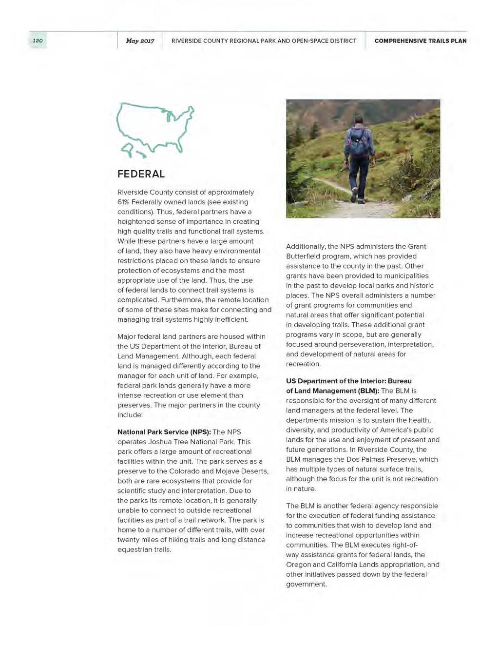
122
123 Chapter 8 PARTNERSHIPS 121 STATE US Fish and Wildlife Service: This departments mission is focused primarily to conserve, protect and enhance fish, wildlife and plants and their habitats. Thus, the scope of this entity is limited to the Coachella Valley National Wildlife Refuge is fairly limited in the trails that are provided for the county or its visitors. The only trail located on this property allows equestrian use, but does not allow for general parking. The trail is primarily a connection for other trails in the area. US Department of Agriculture: US Forest Service: The purpose of the US Forest Service (USFS) is to sustain the health, diversity, and productivity of the nation s forests and grasslands to meet the needs of present and future generations. In Riverside County, the USFS manages the San Bernadino National Forest operations. These operations include the Front Country Ranger and San Jacinto Ranger District. On USFS lands, hiking, mountain biking and equestrian trails are present. Military Installations and Bases: The US military has a presence in and around Riverside County. The US Army Corps of Engineers is responsible for the administration of the Prado Dam, while the dam and its recreational facilities are managed by San Bernardino County. The March Airforce Base also provides for some recreational activities in the county, but is limited by operations of the base itself and tickets must be acquired by the Ticket and Tour Office. The two agencies with responsibilities for trails in Riverside County are the Departments of Parks and Recreation, and Fish and Wildlife. Similar to the federal partners in the county, these are primarily sources of potential funding for grants and other technical assistance. University of California at Riverside: The university is a statewide system of higher institutions with the purpose of postsecondary education. The campus is home to the botanical gardens, a 40-acre site which is home to hiking trails on the campus. The campus is responsible for the maintenance of the trails. CA Department of Parks and Recreation: The CA Department of Parks and Recreation operates similarly to the NPS, in that they provide for state recreational areas on tracts of land that may also help to protect natural and cultural resources. This partner is able to provide valuable funding assistance and is able to assist in making trail connections. CA Department of Fish and Wildlife: The CA Department of Fish and Wildlife serves a similar function to the US Fish and Wildlife Service, but at a state scale of governance. This partner also has limited capacity to manage infrastructure within the county and has primarily been a funding resource.
124 122 May 2017 RIVERSIDE COUNTY REGIONAL PARK AND OPEN-SPACE DISTRICT COMPREHENSIVE TRAILS PLAN PRIVATE Many private groups operate within Riverside County that support either individual trails, trail systems or parks containing trails. These groups range from friend s groups, to health foundations, environmental protection groups, and many others. Environmental Protection Center for Natural Lands Management: The Center for Natural Lands Management (CNLM) manages preserves throughout Washington and California. Their focus is to protect threatened, endangered or rare species and habitats throughout these areas. Each preserve is given its own stewardship staff, who provides for the care of the land and species. In Riverside County, the CNLM manages the following preserves: Bogert Wash, CVAG I-10, Dos Palmas, Four Seasons, Johnson Ranch, Lincoln Ranch, Mockingbird Canyon, Roripaugh Ranch, Skunk Hollow, Smoke Tree, Summerhill, Thousand Palms Oasis, Warm Springs, Wilson Creek and Wilson Valley. Since the focus of these tracts are preservation, it is unlikely that a diverse range of trail uses would be provided in the areas managed by the CNLM. In western Riverside County, the CNLM works to provide for trail maintenance, cleanup and landscaping, and some habitat restoration through seed planting. The organization frequently works with local schools who wish to expose primarily school aged students to the outdoors. In the Thousand Palms Oasis Preserve, the CNLM also provides for similar activities, along with docents in the visitor s center. Volunteers in this preserve also help to lead trail hikes. Inland Empire Waterkeeper: Inland Empire Waterkeeper s mission is to protect and enhance the water quality of the Upper Santa Ana River Watershed through programs of advocacy, education, research, restoration, and enforcement in San Bernardino and Riverside County. The Inland Empire WaterKeeper s small staff have worked to mobilize community efforts since They are a grassroots environmental movement that supports the restoration and enjoyment of the Santa Ana River by its neighbors. The group collects samples water, conducts research, restores habitats and conducts outreach efforts. The group hosts corporate cleanups and other volunteer days. Greater Riverside Chamber of Commerce: The Greater Riverside Chamber is committed to helping local companies grow their business by taking the lead in programs and efforts that help create a strong local economy and make our community a great place to do business. This non-conventional trail partner could be approached to assist with the marketing and promotion of Riverside County Trails and Natural Areas. Other Chambers have been very helpful in promoting businesses and places to live in areas with established trail systems.
125 Chapter 8 PARTNERSHIPS 123 Friends Groups Friends groups typically provide trails with a diverse range of support. This support can come in the means of providing for ongoing trail and trailside cleanup, constructing trail facilities such as restrooms, improving the character of the trail, volunteer work days, fundraisers, and many other activities. These groups provide trail managers with much needed capacity to ensure a trail or park facility functions well as a recreational facility. Generally, friends groups align with a geographic area or specific facility to ensure that resources are not spread thin. Friends of Hidden Valley Preserve: This friends group mission is to maintain and protect Hidden Valley Wildlife Preserve and enhance the educational opportunities it provides for present and future generations. The group accomplishes its goals through providing advocacy, operational support, educational programming, resource management and technological support. This friends group works to fill in resource gaps where the Hidden Valley Nature Center may not have the capacity to fill itself. The site has access to over 25 miles of equestrian and hiking trails. The group helps to staff the center and provide for events. Friends of Riverside Hills: The Friends of Riverside Hills focus is to support the protection, expansion and preservation of open spaces and natural habitats. This group is focused on providing Box Springs Mountain Park with needed amenities for multiple types of paths. The group has also lobbied extensively to entities to provide necessary elements to the park. Friends of the Coachella Valley Link Trail: The Friends of the Coachella Valley (CV) Link has organized around the mission of encouraging a healthy lifestyle and building the CV Link Trail. This trail is a fifty-mile facility that will incorporate multiple new technologies to encourage an active lifestyle. The group organizes trail cleanup and maintenance, operational and educational support, resource management, and advocates for the trail. The CV Link is located in eastern Riverside County. The Friends of the CV Link works to advocate, fundraise, provide office support, create web resources, event planning and other actions to ensure that the trail is built and utilized. The group hosts numerous events in support of the trail, and frequently works with the county to establish partnerships between groups. Friends of the San Jacinto Mountain County Parks: The goal of the this friends group aims to supports the work of the Riverside County Regional Parks & Open Space District in the San Jacinto Mountain Area. In doing so, the group directs equipment purchases, educational and interpretive programming and other assistance to the parks directly. Inland Valley Mountain Bike Association: The Inland Valley Mountain Bike Association aims to develop and care for sustainable, multipleuse trails while fostering a community that participates in healthful activity, preserving the environment and stimulating the local economy through advocacy, education and participation. The group utilizes volunteer time towards the development of trail systems, community meetings and bicycling encouragement events. Riverside Recreational Trails: Founded in 1987 by a group of trail enthusiasts, this group is dedicated to protecting the local trail system and offers many activities throughout the year. The organization provides both equestrian and non-equestrian events. The organization has adopted trail segments for management, constructed facilities and donated money to parks for maintenance and equipment purchases.
126
127 Chapter 8 PARTNERSHIPS 125 Careful coordination with law enforcement and other emergency responders is key to ensuring the overall safety of trail users in rural areas. The sheriffs have mapped off-highway vehicle trails to support this initiative, but it could be expanded to future regional trails since enforcement for these facilities contain similar issues. Riverside County Transportation Commission: The Riverside County Transportation Commission is responsible for planning and implementing transportation and transit improvements, assisting local governments with money for local streets and roads, helping to smooth the way for commuters and goods movement, and ensuring that everyone has access to transportation. The commission is largely responsible for coordinating investments into the transportation system. The commission could serve as a resource in coordinating trail investments and maintenance efforts. Riverside County Transportation Department: The county transportation department is the lead agency for maintenance of roadways, contract services, land development and other typical functions. This department is integral to the development of the overall transportation system within the county, including diverse types of transportation leading into the future. Riverside-Corona Habitat Conservation District: Similar to recreation districts, The Riverside-Corona Habitat Conservation District (RCRCD) special district established in San Bernardino and Riverside County aims to conserve the natural resources of areas within in southern California. The RCRCD provides technical advice to land users, educational programs for the community, and conducts on-the-land conservation projects. The focus on this district is centered on resource preservation and education. Southern California Association of Governments: The Southern California Association of Governments aims to provide a high-quality of life for southern Californians by fostering the realization of regional plans. The organization aims to develop long range regional transportation goals, including sustainable communities, forecast population and transportation growth, housing needs, and improve air quality. This organization will be helpful in the establishment of communications across the region. Western Riverside Council of Governments: The Western Riverside Council of Governments enables this area to speak with a collective voice on important issues. The focus on this entities collective governance is on transportation, environment, energy, economy and health. Western Riverside County Regional Conservation Authority: The Western Riverside County Regional Conservation Authority acquires land for conservation and habitat protection purposes. The organization also reviews development applications and has some trail space on reserves. The primary role of the organization is to provide land management, facilities maintenance, ecological monitoring, and control for unauthorized access. TABLE OF TRAIL PARTNERS A table of the partners in Riverside County, CA has been provided for the purposes of providing ease into which stakeholder is capable of conducting certain tasks. These stakeholders are categorized by scope of operations, and type of tasks conducted. Scope of operations pertains to how large an organization operations from the regional or county level, to the federal level. Types of task are broken down by advocacy, planning, design, management, operations and maintenance, and non-conventional partners. These categories are generalizations and do not reflect the on the ground, every day operations of the organizations
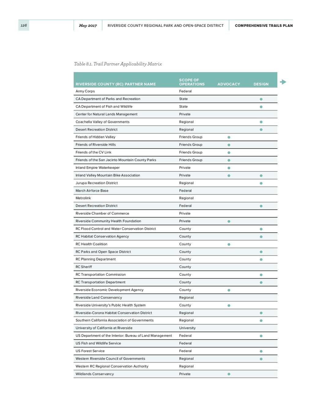
128
CHAPTER 1 INTRODUCTION MORENO VALLEY GENERAL PLAN 1. INTRODUCTION. 1.1 What is a General Plan?
 1. INTRODUCTION 1.1 What is a General Plan? A General Plan is a comprehensive long-term strategy for the physical development of a city. It determines how land may be used and the infrastructure and public
Blueways: Rivers, lakes, or streams with public access for recreation that includes fishing, nature observation, and opportunities for boating.
 Parks, Open Space and Trails PRINCE WILLIAM COUNTY 2008 COMPREHENSIVE PLAN TRAILS PLAN CONTENTS The components of the trails plan are: Intent Definitions Goals, Policies, and Action Strategies Trails Map
FINAL TESTIMONY 1 COMMITTEE ON RESOURCES UNITED STATES HOUSE OF REPRESENTATIVES. July 13, 2005 CONCERNING. Motorized Recreational Use of Federal Lands
 FINAL TESTIMONY 1 STATEMENT OF DALE BOSWORTH CHIEF Of the FOREST SERVICE UNITED STATES DEPARTMENT OF AGRICULTURE Before the SUBCOMMITTEE ON FORESTS AND FOREST HEALTH And the SUBCOMMITTEE ON NATIONAL PARKS,
A CASE FOR COMPLETING THE JORDAN RIVER PARKWAY: A
 A CASE FOR COMPLETING THE JORDAN RIVER PARKWAY: A safe crossing at 9000 South and 850 West Proposed 9000 South Underpass Parkway Timeline Parkway, Trail, and Tourism Facts Blueprint Jordan River 1971 1973
FEASIBILITY CRITERIA
 This chapter describes the methodology and criteria used to evaluate the feasibility of developing trails throughout the study areas. Land availability, habitat sensitivity, roadway crossings and on-street
APPENDIX OFFICIAL MAP ORDINANCE OF HAMILTONBAN TOWNSHIP OFFICIAL MAP NARRATIVE
 APPENDIX A OFFICIAL MAP ORDINANCE OF HAMILTONBAN TOWNSHIP OFFICIAL MAP NARRATIVE INTRODUCTION: The Official Map of Hamiltonban Township has been prepared to identify those lands and features that Hamiltonban
Non-Motorized Transportation
 Non-Motorized Transportation Non-motorized facilities are important components to the transportation system. They provide an environmentally-friendly, low-cost mode of travel. Some of the facilities can
Coast to Coast Connector Summit
 Project Partners Welcome to the Coast to Coast Connector Summit Winter Garden, Florida City Hall October 1, 2014 1 Why are we here? Objectives 1. Inform key stakeholders on the current state of the C2C
Creating a User-Driven Long-Distance OHV Trail Through Partnering
 Joseph Raffaele Outdoor Recreation Planner U.S. Bureau of Land Management Yuma, Arizona Creating a User-Driven Long-Distance OHV Trail Through Partnering BLM is a multiple-use land management agency within
Welcome to the Cross County Trail Public Input Session!
 Welcome to the Cross County Trail Public Input Session! Please sign in on the table below! What are we doing here? Camden County has proposed a bicycle and pedestrian trail spanning across the entire county.
13.1 REGIONAL TOURISM ISSUES AND SUMMARY OF FINDINGS
 13 REGIONAL TOURISM T he County of Mariposa s recreation needs and facilities fall within two categories: regional tourism and local recreation. This Element focuses on regional tourism issues related
Continental Divide National Scenic Trail Legislative History and Planning Guidance
 Continental Divide National Scenic Trail Legislative History and Planning Guidance Legislation, Policy, and Direction Regarding National Scenic Trails The National Trails System Act, P.L. 90-543, was passed
Other Principle Arterials Minor Arterial Major Collector Minor Collector Local
 CHAPTER 10 TRANSPORTATION Introduction The system of public roads in East Pikeland Township is decidedly rural in character. Since the 1984, the road network has remained much the same, with the addition
RE: Access Fund Comments on Yosemite National Park Wilderness Stewardship Plan, Preliminary Ideas and Concepts
 September 30, 2016 Superintendent Yosemite National Park Attn: Wilderness Stewardship Plan P.O. Box 577 Yosemite, CA 95389 RE: Access Fund Comments on Yosemite National Park Wilderness Stewardship Plan,
January 14, Orange County Transportation Authority Attn: M2 NCCP/HCP 550 South Main Street P.O. Box Orange, CA
 Equestrian Trails, Inc. Corral 357 P.O. Box 1026 Trabuco Canyon, CA 92678 http://saddlebackcanyonriders.com/ President: James Iacono... 714-612-1789 January 14, 2016 Orange County Transportation Authority
Preferred Recreation Recommendations Stemilt-Squilchuck Recreation Plan March 2018
 Preferred Recreation Recommendations Stemilt-Squilchuck Recreation Plan March 2018 Below are the recommended recreation ideas and strategies that package together the various recreation concepts compiled
Airport Planning Area
 PLANNING AREA POLICIES l AIRPORT Airport Planning Area LOCATION AND CONTEXT The Airport Planning Area ( Airport area ) is a key part of Boise s economy and transportation network; it features a multi-purpose
MONTEREY REGIONAL AIRPORT MASTER PLAN TOPICAL QUESTIONS FROM THE PLANNING ADVISORY COMMITTEE AND TOPICAL RESPONSES
 MONTEREY REGIONAL AIRPORT MASTER PLAN TOPICAL QUESTIONS FROM THE PLANNING ADVISORY COMMITTEE AND TOPICAL RESPONSES Recurring topics emerged in some of the comments and questions raised by members of the
Parkland County Municipal Development Plan Amendment Acheson Industrial Area Structure Plan
 Parkland County Municipal Development Plan Amendment Acheson Industrial Area Structure Plan New Plan Acheson Industrial Area Structure Plan Amendment Parkland County Municipal Development Plan Board Reference
Logo Department Name Agency Organization Organization Address Information 5700 North Sabino Canyon Road
 Logo Department Name Agency Organization Organization Address Information United States Forest Coronado National Forest 5700 North Sabino Canyon Road Department of Service Santa Catalina Ranger District
University Region Non-Motorized Plan 2015
 Non-Motorized Transportation Non-motorized facilities are important components to the transportation system. They provide an environmentally-friendly, low-cost mode of travel. Some of the facilities can
ANCLOTE COASTAL TRAIL ALTERNATIVES ANALYSIS STUDY
 ANCLOTE COASTAL TRAIL ALTERNATIVES ANALYSIS STUDY PASCO COUNTY MPO JULY 2015 PROJECT OVERVIEW... INTRODUCTION EXECUTIVE SUMMARY CONTEXT... TAMPA BAY AREA, PINELLAS, & PASCO COUNTY S MULTI-USE TRAIL PLANS
Northeast Quadrant Distinctive Features
 NORTHEAST QUADRANT Northeast Quadrant Distinctive Features LAND USE The Northeast Quadrant includes all the area within the planning area that is east of Interstate 5 and to the north of State Route 44.
2. Goals and Policies. The following are the adopted Parks and Trails Goals for Stillwater Township:
 D. PARKS AND TRAILS 1. Introduction Stillwater Township s population is relatively low, with most residents living on rural residences on large lots. The need for active park space has been minimal in
EXECUTIVE SUMMARY PROGRAM DEVELOPMENT REPORT PURPOSE EXISTING SETTING EXPANDING PARKLAND
 EXECUTIVE SUMMARY PROGRAM DEVELOPMENT REPORT PURPOSE As the culmination of the first phase of the master planning process, this Program Development Report creates the framework to develop the Calero County
Section II. Planning & Public Process Planning for the Baker/Carver Regional Trail began in 2010 as a City of Minnetrista initiative.
 Section II Planning & Public Process Planning for the began in 2010 as a City of initiative. city staff began discussions with the Park District on the possibility of a north/south regional trail connection
$866,000. $1,400,000 Health Benefits $13,156,000 TOTAL ANNUAL DIRECT BENEFITS. $10,890,000 Economic Benefits
 SINGING RIVER TRAIL Trails Create Value + Generate Economic Activity Trails generate economic returns through improved health, safety, and environmental conditions, raise property values, and attract visitors.
NAVAJO COMMUNITY PLAN
 NAVAJO COMMUNITY PLAN Prepared by the NAVAJO COMMUNITY PLANNERS and THE CITY OF SAN DIEGO City of San Diego Planning Department 202 C Street, MS 4A San Diego, CA 92101 Printed on recycled paper. This information,
Map 1.1 Wenatchee Watershed Land Ownership
 Map 1.1 Wenatchee Watershed Land Ownership Map 1.1 Wenatchee Watershed Land Ownership The Wenatchee watershed lies in the heart of Washington state in Chelan County. Just larger than the state of Rhode
Regional Wayfinding Sign Strategy Thurston County Trails 2017
 Regional Wayfinding Sign Strategy Thurston County Trails 2017 Partners: Members and partnering organizations of the Thurston Thrives Community Design Action Team City of Lacey, City of Olympia, City of
COASTAL CONSERVANCY. Staff Recommendation December 2, 2004 COYOTE HELLYER COUNTY PARK BAY AREA RIDGE TRAIL
 COASTAL CONSERVANCY Staff Recommendation December 2, 2004 COYOTE HELLYER COUNTY PARK BAY AREA RIDGE TRAIL File No. 04-057 Project Manager: Amy Hutzel RECOMMENDED ACTION: Authorization to disburse up to
Rule Governing the Designation and Establishment of All-Terrain Vehicle Use Trails on State Land
 Rule Governing the Designation and Establishment of All-Terrain Vehicle Use Trails on State Land 1.0 Authority 1.1 This rule is promulgated pursuant to 23 V.S.A. 3506. Section 3506 (b)(4) states that an
City of Durango 5.8 FUNDING TRAILS DEVELOPMENT
 5.8 FUNDING TRAILS DEVELOPMENT The City has been successful in establishing dedicated local funding sources as well as applying for grants to develop the City s trail system, having received nearly $2.4
Business Item No
 Metropolitan Parks and Open Space Commission Meeting date: February 6, 2018 For the Community Development Committee meeting of February 20, 2018 For the Metropolitan Council meeting of February 28, 2018
Trail Feasibility Study
 VOLUSIA COUNTY MPO CITY OF NEW SMYRNA BEACH FINAL REPORT JUNE 30, 2009 Trail Feasibility Study What s inside? 1 Introduction 2 Project Purpose & Scope 3 Physical Inventory & Assessment of Right-of- Way
Chapter 6: POLICY AND PROCEDURE RECOMMENDATIONS
 Chapter 6 POLICY AND PROCEDURE RECOMMENDATIONS FOR SRRA Below are seven policy elements that should be considered for adoption by the Southwest Regional Recreation Authority of Virginia: 1. Develop strategies
Classifications, Inventory and Level of Service
 Classifications, Inventory and Level of Service Section 3 Kenmore Park, Recreation and Open Space Plan 1 P a g e Classifications and Inventory Park Classifications Kenmore classifies its parks based upon
AGENDA ITEM 5 D WAKULLA ENVIRONMENTAL INSTITUTE (WEI) TRAIL FEASIBILITY STUDY
 TRAIL FEASIBILITY STUDY") March 19, 2018 AGENDA ITEM 5 D WAKULLA ENVIRONMENTAL INSTITUTE (WEI) TRAIL FEASIBILITY STUDY TYPE OF ITEM: Action STATEMENT OF ISSUE The Wakulla Environmental Institute (WEI) Trail is one of several trails
March 19, 2018 AGENDA ITEM 5 D WAKULLA ENVIRONMENTAL INSTITUTE (WEI) TRAIL FEASIBILITY STUDY TYPE OF ITEM: Action STATEMENT OF ISSUE The Wakulla Environmental Institute (WEI) Trail is one of several trails
Economic Development and Tourism
 SECTION 4 SECTION 4 Economic Development and Tourism 4. Economic Development and Tourism Tourism plays a very important role in Niagara s economy, providing employment and generating business for support
CHAPTER FIVE PROSPECTS FOR FUTURE ECONOMIC DEVELOPMENT
 CHAPTER FIVE PROSPECTS FOR FUTURE ECONOMIC DEVELOPMENT 5.1 GENERAL The recommended type and location of future land uses in Alpine should, in part, consider potential opportunities for future economic
2016 Regional Transportation Alternatives Program (TAP) Grant Application
 Grant Application") 2016 Regional Transportation Alternatives Program (TAP) Grant Application PROJECT TITLE: Yelm-Tenino Trail Extension Feasibility Study TRPC use only GENERAL PROJECT INFORMATION Agency or Organization City
2016 Regional Transportation Alternatives Program (TAP) Grant Application PROJECT TITLE: Yelm-Tenino Trail Extension Feasibility Study TRPC use only GENERAL PROJECT INFORMATION Agency or Organization City
Chapter 2: Summary of Existing Open Space System
 Chapter 2: Summary of Existing Open Space System In 1976, the Wake County Board of Commissioners established the Wake County Parks and Recreation Department in order to provide park facilities and programs
RUSHMORE CONNECTOR TRAIL PROPOSAL
 PURPOSE AND NEED Background The U.S. Forest Service, Black Hills National Forest (Forest Service) has received a special use permit application from the State of South Dakota Department of Game, Fish and
Tahoe National Forest Over-Snow Vehicle Use Designation
 Tahoe National Forest Over-Snow Vehicle Use Designation USDA Forest Service Tahoe National Forest February 20, 2015 Introduction The Forest Service, U.S. Department of Agriculture will prepare an Environmental
UNITED STATES DEPARTMENT OF THE INTERIOR BUREAU OF LAND MANAGEMENT MANUAL TRANSMITTAL SHEET
 Form 1221-2 (June 1969) UNITED STATES DEPARTMENT OF THE INTERIOR BUREAU OF LAND MANAGEMENT MANUAL TRANSMITTAL SHEET Release 8-83 Date Subject 8353 Trail Management Areas Secretarially Designated (Public)
Martinez General Plan 2035 White Paper TRAILS
 Martinez General Plan 2035 White Paper TRAILS November 2016 The Issue The draft Martinez General Plan 2035 and Draft Program Environmental Impact Report were released for public review on September 15,
Florida National Scenic Trail 5-Year Strategic Plan. Barbara Bowen
 Florida National Scenic Trail 5-Year Strategic Plan 2012 Barbara Bowen Florida National Scenic Trail M. Timothy O Keefe M. Timothy O Keefe Mike Knox 20-mile Planning Corridor Florida National Scenic Trail
Committee. Presentation Outline
 CW-33-15 11/9/2015 Community and Corporate Services Committee November 10, 2015 1 Presentation Outline Background Vision and Objectives Study Process and Timeline Public and Stakeholder Engagement Organization
Rogue River Access and Management Plan Draft Alternatives
 Rogue River Access and Management Plan Draft Alternatives The Rogue River Access and Management Plan was initiated in December, 2011 and is being led by Jackson County Parks (JCP) and Oregon Department
SOUTH INTERCHANGE AREA
 Santaquin City General Plan 1 Location and Characteristics The South Interchange Area of Santaquin is located west of Interstate 15 and south of 500 South (Figure 1). It includes properties already annexed
Longmont to Boulder Regional Trail Jay Road Connection DRAFT FINAL REPORT
 Longmont to Boulder Regional Trail Jay Road Connection DRAFT FINAL REPORT December 2018 Project Summary Boulder County, Colorado, in partnership with the City of Boulder, is evaluating options for multi-use
Chatsworth Branch Library Devonshire Street, Chatsworth, CA Thursday, November 16, :00-8:00 pm
 Chatsworth Branch Library 21052 Devonshire Street, Chatsworth, CA 91311 Thursday, November 16, 2017 6:00-8:00 pm Project Team County of Los Angeles Department of Parks and Recreation Kathline King Chief
List of Figures... 4 List of Maps... 6 Introduction... 7 Data Sources... 8
 SERVICE EVALUATION APRIL 2014 Table of Contents List of Figures... 4 List of Maps... 6 Introduction... 7 Data Sources... 8 Service Overview and Service Fundamentals System Overview... 9 Service Area...
CHAPTER 5. Chapter 5 Recreation Element
 CHAPTER 5 Recreation Element Chapter 5 Recreation Element The Recreation Element of the Meyers Area Plan is a supplement to the Recreation Element of the TRPA Regional Plan and the El Dorado County General
CHAPTER ONE LITERATURE REVIEW
 CHAPTER ONE LITERATURE REVIEW LITERATURE REVIEW This chapter summarizes the most recently published community impact studies and articles that relate to multiuse trails. The review focuses on publications
Stevenson Ranch Library The Old Road, Stevenson Ranch, CA Thursday, November 9, :00-8:00 pm
 Stevenson Ranch Library 25950 The Old Road, Stevenson Ranch, CA 91381 Thursday, November 9, 2017 6:00-8:00 pm Project Team County of Los Angeles Department of Parks and Recreation Kathline King Chief of
Tracy Ridge Shared Use Trails and Plan Amendment Project
 Tracy Ridge Shared Use Trails and Plan Amendment Project Scoping Document Forest Service Allegheny National Forest Bradford Ranger District McKean, County, Pennsylvania In accordance with Federal civil
STAFF REPORT. Airport Land Use Plan Consistency Review: Santa Barbara Airport Master Plan. MEETING DATE: November 19, 2015 AGENDA ITEM: 7D
 STAFF REPORT SUBJECT: Airport Land Use Plan Consistency Review: Santa Barbara Airport Master Plan MEETING DATE: AGENDA ITEM: 7D STAFF CONTACT: Peter Imhof, Andrew Orfila RECOMMENDATION: Adopt findings
April 10, Mark Stiles San Juan Public Lands Center Manager 15 Burnett Court Durango, CO Dear Mark,
 Mark Stiles San Juan Public Lands Center Manager 15 Burnett Court Durango, CO 81301 Dear Mark, We are pleased to offer the following comments on the draft San Juan Public Lands Center management plans
11. Recreational Trails and Pathways Needs
 11. Recreational Trails and Pathways Needs Background Walking, biking, hiking, in-line skating, canoeing, and other trail- and pathway-related activities are important to Boiseans. This importance is demonstrated
Executive Summary. MASTER PLAN UPDATE Fort Collins-Loveland Municipal Airport
 Executive Summary MASTER PLAN UPDATE Fort Collins-Loveland Municipal Airport As a general aviation and commercial service airport, Fort Collins- Loveland Municipal Airport serves as an important niche
Segment 2: La Crescent to Miller s Corner
 goal of the USFWS refuges is to conserve, protect and enhance fish, wildlife and plants and their habitats for the continuing benefit of the American people. Refuge lands are used largely for fishing,
DRAFT - APRIL 13, 2007 ROUTING STUDY FOR TRAIL CONNECTIONS BETWEEN CALAIS AND AYERS JUNCTION
 DRAFT - APRIL 13, 2007 ROUTING STUDY FOR TRAIL CONNECTIONS BETWEEN CALAIS AND AYERS JUNCTION Abstract The vision for the East Coast Greenway is an off-road urban trail system running from Calais, Maine
PURPOSE AND NEED (CONCURRENCE POINT 1) NEW CANADA ROAD PROJECT FROM STATE ROUTE 1 (U.S. HIGHWAY 70) TO U.S. INTERSTATE 40
 NEW CANADA ROAD PROJECT FROM STATE ROUTE 1 (U.S. HIGHWAY 70) TO U.S. INTERSTATE 40") PURPOSE AND NEED (CONCURRENCE POINT 1) NEW CANADA ROAD PROJECT FROM STATE ROUTE 1 (U.S. HIGHWAY 70) TO U.S. INTERSTATE 40 Project Description The primary purpose of this project is to improve the major
PURPOSE AND NEED (CONCURRENCE POINT 1) NEW CANADA ROAD PROJECT FROM STATE ROUTE 1 (U.S. HIGHWAY 70) TO U.S. INTERSTATE 40 Project Description The primary purpose of this project is to improve the major
Part Three : COMMUNITY PLAN AREAS AND SPECIAL STUDY AREAS SACRAMENTO 2030 GENERAL PLAN. Introduction
 Special study Areas Part Three : COMMUNITY PLAN AREAS AND SPECIAL STUDY AREAS SACRAMENTO 2030 GENERAL PLAN Introduction Beyond the boundaries of the 2030 General Plan, the City has defined Special Study
CHAPTER 4 -- THE LAND USE PLAN: DESCRIPTIONS AND POLICIES FOR THIRTEEN PLANNING AREAS
 CHAPTER 4 -- THE LAND USE PLAN: DESCRIPTIONS AND POLICIES FOR THIRTEEN PLANNING AREAS NORTH CENTRAL CAC AREA LITTLE VALLEY ROAD TO JUG HANDLE CREEK PLANNING AREA This planning area includes Cleone, Noyo,
4.0 Context for the Crossing Project
 4.0 Context for the Crossing Project This section provides background information about key features of the North Douglas Crossing project area, and opportunities and constraints. This information is important
ONTARIO TRAILS COUNCIL FAQ
 Trail Facts Ontario has some of the most treasured and protected outdoor areas in the world with: 329 Provincial Parks 400 Conservation Areas 292 Conservation Reserves Many people link trails with recreation
The Vision for the San Juan Islands Scenic Byway
 The Vision for the San Juan Islands Scenic Byway 2 Judd Cove, Orcas Island, Courtesy of Kurt Thorson (kurtthorson.com) and San Juan County Land Bank Vision for the San Juan Islands Scenic Byway The San
Partners: Michigan California Timber Company Shasta-Trinity National Forest Pacific Crest Trail Association The Trust for Public Land
 Partners: Michigan California Timber Company Shasta-Trinity National Forest Pacific Crest Trail Association The Trust for Public Land Describe the project location, size, opportunities, and timing. Provide
March 14, SUBJECT: Public input to the Bureau of Land Management, Gunnison Field Office, Travel Management Plan
 March 14, 2019 Delivered via email to ewaters@blm.gov Elijah Waters Field Manager BLM Gunnison Field Office Gunnison, CO 81230 SUBJECT: Public input to the Bureau of Land Management, Gunnison Field Office,
TransAction Overview. Introduction. Vision. NVTA Jurisdictions
 Introduction Vision NVTA Jurisdictions In the 21 st century, Northern Virginia will develop and sustain a multimodal transportation system that enhances quality of life and supports economic growth. Investments
RIVERSIDE TRANSIT AGENCY 1825 Third Street Riverside, CA July 23, 2009
 RIVERSIDE TRANSIT AGENCY 1825 Third Street Riverside, CA 92507 July 23, 2009 TO: THRU: FROM: BOARD OF DIRECTORS Larry Rubio, Chief Executive Officer Tom Franklin, Chief Operating Officer SUBJECT: Ridership
This page has been intentionally left blank.
 This page has been intentionally left blank. Chapter 2 2-2 2. Growing the Economy In many ways, the Niagara Region is a community of communities and this is becoming increasingly so. It is made up of towns
Dumont Dunes Special Recreation Management Area (SRMA)
") Dumont Dunes Special Recreation Management Area (SRMA) RMA/RECREATION MANAGEMENT ZONE (RMZ) OBJECTIVE(S) DECISIONS Objective Statement: Designate this area as a Special Recreation Management Area. To manage
Dumont Dunes Special Recreation Management Area (SRMA) RMA/RECREATION MANAGEMENT ZONE (RMZ) OBJECTIVE(S) DECISIONS Objective Statement: Designate this area as a Special Recreation Management Area. To manage
Agenda: SASP SAC Meeting 3
 Agenda: SASP SAC Meeting 3 Date: 04/12/18 Public Involvement Plan Update Defining the System Recommended Classifications Discussion Break Review current system Outreach what we heard Proposed changes Classification
Macleod Trail Corridor Study. Welcome. Macleod Trail Corridor Study Open House. Presentation of Proposed Design Concepts
 Macleod Trail Corridor Study Welcome Macleod Trail Corridor Study Open House Presentation of Proposed Design Concepts Study Purpose Develop a corridor plan for Macleod Trail that aligns with The City s:
3.0 LEARNING FROM CHATHAM-KENT S CITIZENS
 3.0 LEARNING FROM CHATHAM-KENT S CITIZENS An important aspect in developing the Chatham-Kent Trails Master Plan was to obtain input from stakeholders and the general public. Throughout the course of the
White Mountain National Forest Saco Ranger District
 United States Department of Agriculture Forest Service White Mountain National Forest Saco Ranger District 33 Kancamagus Highway Conway, NH 03818 Comm: (603) 447-5448 TTY: (603) 447-3121 File Code: 1950
Proposed Action. Payette National Forest Over-Snow Grooming in Valley, Adams and Idaho Counties. United States Department of Agriculture
 United States Department of Agriculture Forest Service January 2012 Proposed Action Payette National Forest Over-Snow Grooming in Valley, Adams and Idaho Counties Payette National Forest Valley, Adams
Aviation, Rail, & Trucking 6-1
 6-1 This chapter describes the services, facilities, and condition of air, rail, and trucking as components of the transportation system. These three intermodal areas have an impact on the factors to be
JOSLIN FIELD, MAGIC VALLEY REGIONAL AIRPORT DECEMBER 2012
 1. Introduction The Federal Aviation Administration (FAA) recommends that airport master plans be updated every 5 years or as necessary to keep them current. The Master Plan for Joslin Field, Magic Valley
Lafourche Parish Government REQUEST FOR QUALIFICATIONS. Landscape Architectural Services
 Lafourche Parish Government REQUEST FOR QUALIFICATIONS Landscape Architectural Services Bayou Lafourche Parish Multi-Use Path Feasibility Study Phase 1 And Bayou Lafourche Parish Multi-Use Path Feasibility
PLANNING COMMISSION AGENDA REPORT May 10, Members of the Planning Commission. Joyce Parker-Bozylinski, Contract Planner
 PLANNING COMMISSION AGENDA REPORT May 10, 2007 TO: FROM: PROPOSAL: APPLICANT: RECOMMENDATION: Members of the Planning Commission Joyce Parker-Bozylinski, Contract Planner Approval of the Calabasas Trails
The Recreational Trail along Cushing Park road has been a successful addition to the city
 The Recreational Trail along Cushing Park road has been a successful addition to the city Trails TRAILS, PATHS, ROUTES AND CONNECTORS Citizen input pointed to trails, paths, bike routes, and other non-motorized
The San Diego Region s Air Transportation Future
 The San Diego Region s Air Transportation Future June 22, 2006 1 Ryan N. Hall, Airport System Planner II San Diego County Regional Airport Authority Presentation Overview 1. The law 2. The ballot measure
CHAPTER 6 NOISE EXPOSURE
 CHAPTER 6 NOISE EXPOSURE FAA requires that the NEM submitted for review represent the aircraft noise exposure for the year of submittal (in this case 2008) and for a future year (2013 for OSUA). However,
METROPOLITAN COUNCIL 390 North Robert Street, St. Paul, MN Phone (651) TDD (651)
 TDD (651)") DATE: March 27, 2012 METROPOLITAN COUNCIL 390 North Robert Street, St. Paul, MN 55101 Phone (651) 602-1000 TDD (651) 291-0904 TO: Metropolitan Parks and Open Space Commission FROM: Arne Stefferud, Planning
DATE: March 27, 2012 METROPOLITAN COUNCIL 390 North Robert Street, St. Paul, MN 55101 Phone (651) 602-1000 TDD (651) 291-0904 TO: Metropolitan Parks and Open Space Commission FROM: Arne Stefferud, Planning
Chapter 1 Introduction and Project Overview
 Chapter 1 Introduction and Project Overview Kittitas County in cooperation with the Federal Aviation Administration (FAA) is updating the Airport Master Plan for Bowers Field Airport (FAA airport identifier
Business Item No XXX. Proposed Action That the Metropolitan Council approve the Coon Creek Regional Trail Master Plan.
 Business Item No. 2015-XXX Metropolitan Parks and Open Space Commission Meeting date: July 7, 2015 For the Community Development Committee meeting of July 20, 2015 For the Metropolitan Council meeting
Georgetown-Lewes Rail/Trail Study. Rail/Trail Study: Cool Spring to Cape Henlopen State Park New Road Extension (House Resolution No.
 Georgetown-Lewes Rail/Trail Study Rail/Trail Study: Cool Spring to Cape Henlopen State Park New Road Extension (House Resolution No. 47) August 22, 2011 Presentation Outline Background Benefits Statewide
Gold Coast. Rapid Transit. Chapter twelve Social impact. Chapter content
 Gold Coast Rapid Transit Chapter twelve Social impact Chapter content Social impact assessment process...235 Existing community profile...237 Consultation...238 Social impacts and mitigation strategies...239
Thank you for the opportunity to comment on the proposed action to add trails and trailheads to the Red Rock District trail system.
 July 14, 2010 Jennifer Burns Red Rock Ranger District PO Box 20429 Sedona, AZ 86341 Flagstaff Biking Organization PO Box 23851 Flagstaff, AZ 86002 Dear Jennifer- Thank you for the opportunity to comment
DEMOGRAPHICS AND EXISTING SERVICE
 EXECUTIVE SUMMARY The Central Corridor light-rail transit (LRT) project will open in 2014 and operate between downtown Minneapolis and downtown St. Paul, serving the University of Minnesota and University
Stage 2 ION: Light Rail Transit (LRT) from Kitchener to Cambridge
 from Kitchener to Cambridge") Stage 2 ION: Light Rail Transit (LRT) from Kitchener to Cambridge Public Consultation Centre (PCC) No. 3 Please Sign-in Cambridge City Hall November 21, 2017 2:00 to 8:00pm Preston Memorial Auditorium
Stage 2 ION: Light Rail Transit (LRT) from Kitchener to Cambridge Public Consultation Centre (PCC) No. 3 Please Sign-in Cambridge City Hall November 21, 2017 2:00 to 8:00pm Preston Memorial Auditorium
At the time, the portion of the line through Eagle County remains wholly under the ownership of Union Pacific Railroad (UP).
.") Chapter 5 The Railroad Corridor as a Trail Corridor The intent of this chapter is to identify how the rail corridor, if available for lease or purchase in all or part, could be incorporated into the core
Chapter 5 The Railroad Corridor as a Trail Corridor The intent of this chapter is to identify how the rail corridor, if available for lease or purchase in all or part, could be incorporated into the core
Interstate 90 and Mercer Island Mobility Study APRIL Commissioned by. Prepared by
 Interstate 90 and Mercer Island Mobility Study APRIL 2017 Commissioned by Prepared by Interstate 90 and Mercer Island Mobility Study Commissioned by: Sound Transit Prepared by: April 2017 Contents Section
PREFACE. Service frequency; Hours of service; Service coverage; Passenger loading; Reliability, and Transit vs. auto travel time.
 PREFACE The Florida Department of Transportation (FDOT) has embarked upon a statewide evaluation of transit system performance. The outcome of this evaluation is a benchmark of transit performance that
PSP 75 Lancefield Road. Northern Jacksons Creek Crossing Supplementary Information
 PSP 75 Lancefield Road Northern Jacksons Creek Crossing Supplementary Information September 2017 The northern crossing of Jacksons Creek proposed within the Lancefield Road PSP is a key part of the ultimate
Business Growth (as of mid 2002)
") Page 1 of 6 Planning FHWA > HEP > Planning > Econ Dev < Previous Contents Next > Business Growth (as of mid 2002) Data from two business directories was used to analyze the change in the number of businesses
Page 1 of 6 Planning FHWA > HEP > Planning > Econ Dev < Previous Contents Next > Business Growth (as of mid 2002) Data from two business directories was used to analyze the change in the number of businesses