Cape Breton Trail Review and Inventory Draft Report
|
|
|
- Emil Carter
- 5 years ago
- Views:
Transcription


1 Cape Breton Trail Review and Inventory Draft Report Prepared for Destination Cape Breton by Cobequid Trails in association with RMA Tourism Ltd. January, 2016
2 CAPE BRETON TRAIL REVIEW AND INVENTORY 2 Table of Contents Page Introduction 1 Objectives of the report 2 Background 5 Study Area 5 Trail Classification 7 Trail Use for Tourism 7 Hiking and Walking Trails 8 Citations 9 1. Federal Trails 10 Cape Breton Highland National Park Louisbourg National Historic Site 2. Provincial Park Trails Community and Municipal Trails 14 Richmond County 14 Cape Breton Regional Municipality 15 Victoria County 16 Inverness County Planned and Proposed Hiking Trails 20 Off-road Cycling Trails 23 Mountain Bike Trails 23 Linear Cycling Trails 23 All-Season Motorized Trails 26 The ATV Market 26 ATV Trails in Cape Breton 26 Richmond Co 28 CBRM 30 Victoria County 32 Inverness County 34 Winter Trails Cross Country Ski Trails 36 Snowmobile Trails 36 Conclusion and Recommendations 38 Appendix A. Listing of non-motorized Trails B. Listing of motorized trail networks C. Citations of hiking and walking trails Cape Breton Trail Review and Inventory January 1, 2016

3 CAPE BRETON TRAIL REVIEW AND INVENTORY 3 Introduction This report was commissioned by Destination Cape Breton to provide an inventory of trails on Cape Breton Island. The report covers all major categories of off-road trail corridors including non-motorized and motorized recreational trails. To meet the demands of the nature inclined tourist, Cape Breton has a wide array of outstanding trails. They allow visitors to fully experience the environment. Trails may be destination products in themselves but more often they are part of a diverse product that is essentially inspired by the landscape. Some trails are local resources that may simply improve the quality of outdoor recreation in urban and rural communities. But on Cape Breton Island, with its impressive coastal landscape (both Atlantic Ocean and Bras d Or Lake), National and Historic Parks and an active and developed tourism industry, trails are a vital tourism asset. In 2003, Enterprise Cape Breton requested the Economic Planning Group to prepare a comprehensive trails strategy for Cape Breton Island. The report, almost 200 pages long, reviewed in detail the market for various types of trail users and set priorities and plans for trail development. This report, completed thirteen years after the EPG study, is intended to be a concise summary of trail product in Cape Breton. It provides a database of trails in Cape Breton as they exist today. This database is provided both as a categorized listing and (in the case of hiking and walking trails) as a geo-referenced table. Both can be updated and expanded to include new developments and new information as it is added. We have attempted to list all existing trails that have tourism potential or value. Over 140 trails are listed in this report. Within the limited scope of this study, it was not feasible to conduct site assessments of each trail. This report therefore relied on secondary sources of information to create a composite of the trail product including a brief profile of each trail. Trail coordinators in each county were consulted to identify municipal and community trails. Where on-line data was unavailable, specifically in the case of motorized trails, a trail questionnaire was distributed and personal interviews were conducted. Cape Breton Trail Review and Inventory January 1, 2016
4 CAPE BRETON TRAIL REVIEW AND INVENTORY 4 We focused in this report on land-based trails. Cape Breton has an active water route network especially for cruising boats such as sailing vessels. It also has a number of staging sites for canoes and kayaks. Water routes generally consist of shore-based infrastructure such as yacht clubs and launch sites. While a case could be made that water-routes are classified as trails, this report does not take that position and water routes are not considered trails in this report. For more information on coastal waterways, sea kayak routes and canoe waterways, refer to This report considers the concept of market readiness within the trail inventory. While it was outside the scope of the project to conduct market-readiness assessments of individual trails, the market potential and range of market readiness was generally reviewed for each trail type or grouping. This is important in the context of tourism as market-readiness is an essential condition for trails if they are to make meaningful contributions to the tourism product mix in Cape Breton. The report is organized as follows: The report begins with an overview of the study area. It then describes briefly the taxonomy of trails and trail types used in this report. We then provide a profile and description of each type of trail including all-season trails (hiking and walking trails, cycling trails and all-season offhighway vehicle (OHV) trails) and winter trails (Cross country ski and snowmobile). We conclude the report with brief recommendations for further action. Within the appendix of this report is a comprehensive listing of trails covered in this report. Objectives of the report: A. Identify and describe major trail types B. Report on the state each category of trail number of trails, distance, type and range of management and factors that would determine destination appeal. C. Provide a listing of all trails identified in the study by class and management identifying parameters such as distance and user type. Cape Breton Trail Review and Inventory January 1, 2016

5 CAPE BRETON TRAIL REVIEW AND INVENTORY 5 Study Area Cape Breton Island is the northeastern region of Nova Scotia with a land area of 10,300 square kilometers. This island divided into four counties, Inverness on the northwest coast of the island, Victoria on the northeast, CBRM including Nova Scotia s second largest city to the east and Richmond County at the southwest end of the Island. Cape Breton Island has at least 1500 km. of coastline. The Bras d Or Lake adds an additional 1,234 km. of inland coastline 1. In total, the island has a remarkable 2,700 km. of highly diverse coastline. Land in Cape Breton is generally divided into federal, provincial, municipal and private. Federal land is largely confined to national parks and historic sites. Cape Breton Island National Park accounts for 948 sq. km, almost 10% of the land area of the Island. The remaining 90% is divided between provincial crown land and private and municipal land. The Bras d Or Lake and its watershed (central portion of Cape Breton Island) were designated as a Biosphere Reserve under the UNESCO Man and the Biosphere Program in Provincial crown land represents the largest land classification on Cape Breton. For the purpose of this study, provincial crown land is divided into three general categories. provincial parks wilderness protected areas 1 Taylor RB, and Shaw J Coastal character and coastal barrier evolution in the Bras d Or Lakes, Nova Scotia in Proceeding of the Nova Scotia Institute of Science, 42: Cape Breton Trail Review and Inventory January 1, 2016

6 CAPE BRETON TRAIL REVIEW AND INVENTORY 6 all other crown land Crown land that is not protected under the Parks Act or Wilderness Areas legislation is administered by the Department of Natural Resources and may have a range of uses including industrial forestry, other industrial uses, hunting and fishing and outdoor recreation. Crown land is shown in light green on the following map. Trail Classification Trails are off-road pathways developed for recreation and travel and include corridors for both non-motorized and motorized activity. In this report trails are classified based on the general type of activity. This taxonomy is a market-related classification that reflects userpatterns and relates to travel motivations and preferences. Trails generally fall into the following categories: Trails managed for multi-season use and activities including: o Non-motorized trail use hiking (including front-country walking trails and wilderness trails) off-road cycling Cape Breton Trail Review and Inventory January 1, 2016
7 CAPE BRETON TRAIL REVIEW AND INVENTORY 7 o Trails that accommodate motorized travel, specifically trails for all-terrain vehicles (ATVs) and off-road motorcycles. Trails managed for winter use including: o non-motorized winter trail activities such as cross-country skiing, snowshoeing o snowmobile trails Within the trails data sheets at the end of this report, all-season (non-motorized and motorized) trails are listed sequentially followed by winter trails. Trail classifications by NS Trails include two additional categories: Shared use, and multi-use. Shared use refers to trails than allow both motorized and non-motorized use. A number of rails-to-trails in Nova Scotia are constructed and maintained to shared-use standards. In addition, most OHV trail organizations refer to their trails as shared-use. Multi-use trails refer to trails that are managed for a mix of non-motorized users. Trail use for Tourism Trails are a recreational resource for both residents of Cape Breton Island and visitors. This report is intended to be a resource for tourism planning and therefore focuses on trails that attract and are used by tourists. The following table shows the level of participation in trail activities in Cape Breton by nonresident (out-of-province) visitors. Hiking 34% Cycling 3% Cross-country skiing 2% ATV 2% Snowmobiling 4% Hiking clearly is the most popular trail related activity by tourists (out of province) with over one third (34%) of all visitors participating. It is assumed that most hikers use designated trails. The participation rates for cycling, cross-country skiing, ATV use and snowmobiling are all at less than 5%. Winter activities such as cross-country skiing (2%) and snowmobiling (4%) are important because they stimulate and create tourism activity in winter when vacancy rates are high and tourism revenues are most valuable. Visitors who participate in cycling (representing 3% of tourists) may include use of managed trails and/or public roads. Based on this data, we cannot accurately deduce the degree to which cyclists use trails on Cape Breton Island. Visitors who participate in ATV activities represent 2% of visitors. ATVers may use a combination of managed trails, secondary or commercial roads, roadside, right of ways, etc. However it is assumed that and in most cases, visitors to the Island who engage in ATV recreation at least in part, use managed trails. Cape Breton Trail Review and Inventory January 1, 2016

8 CAPE BRETON TRAIL REVIEW AND INVENTORY 8 Hiking and Walking Trails Hiking is one of the most popular activities by out-of-province visitors. 34% of visitors to the province of Cape Breton participate in hiking. Among international visitors, the participation rate is more than 50%. Hiking and walking trails can be classified as follows: Urban Trails Urban trails include urban park trails, waterfront boardwalks and greenways. Front Country Front country trails include day use trails accessible to most users, age groups, etc. This generally includes nature and heritage trails. Wilderness Trails Wilderness trails include long distance, back-country and overnight trails. They generally have a narrow trail corridor with limited or no built tread. Linear and multi-use trails Linear trails include footpaths or multi-use trails that connect communities and cover long distances. The distinction between front country and wilderness trails must be confirmed through on-site assessment. In this report we classify walking and hiking trails including front country and wilderness trails all within the category hiking trails. Linear and urban trails are grouped separately. This report identified 130 hiking and walking trails on Cape Breton. The complete list is provided in appendix 1. This compilation includes both formal and built trails as well as mixed or shared-use trails. Shared-use trails are listed as hiking trails only where they are recognized as hiking or walking experiences. Generally the listing excludes listed hikes where no formal trail exists. Cape Breton Trail Review and Inventory January 1, 2016
9 CAPE BRETON TRAIL REVIEW AND INVENTORY 9 Citations by Trail Related Websites and Brochures Numerous trail websites and some printed brochures identify, list and describe various trails on Cape Breton Island. Travelers looking for trail information on the Island can locate trail experiences using one or more of these sources. In this report these sources were used to identify and corroborate trail and trail locations. We also identified and recorded the number of citations for each trail by websites and trail brochures. Sites reviewed included the following: Source Type Symbol 1 Trails.com Website T 2 Trail Peak Website TP 3 Destination Cape Breton Trails Website DCB 4 National Geographic Trails Website NG 5 Vic s Trails Website VT 6 Cape Breton Regional Municipality Trails Brochure CBRM 7 Hike NS Website HNS 8 Trails Nova Scotia Website TNS 9 Mike Haynes Hiking Cape Breton Guide book MH 10 Moosebait Website Mb 11 Victoria County Hiking Trails Brochure VCHT 12 Parks Canada Trails Website PC 13 Hike Cape Breton Website HCB 14 Hike the Highlands Website HtH 15 Bras d Or Lake Biosphere Reserve Association Website BLBRA Recognized trails have a large number of citations. This may be due to unique landscapes, outstanding features, quality of the trail, etc. While this is not a scientific method of evaluating destination appeal or market readiness, it does provide a metric of assessment that in most cases corresponds to destination appeal and market readiness. Unsurprisingly, trails with the highest number of citations are predominantly trails within Cape Breton Highland National Park. A ranked list of hiking and walking trails (ranked by number of citations) is included in appendix 3. Please note that while not included in the above listing, Go Riding Magazine cited Cape Breton ATV Trails many times, and also produced a TV show, which gave national and international recognition to its followers, citing the incredible ATVing experiences to be had in Cape Breton. Cape Breton Trail Review and Inventory January 1, 2016
10 CAPE BRETON TRAIL REVIEW AND INVENTORY 10 Review of Hiking and Walking Trails Hiking and walking trails within 4 broad management regimes: 1. Federal Parks and Historic Sites 2. Provincial Parks 3. Provincial Wilderness Areas 4. Municipal and Community Trails 1. Federal This category includes trails within Parks Canada sites including national parks and national historic sites. Cape Breton Highlands National Park (CBHNP) There are 26 trails within CBHNP. Trails range from less than half a kilometer to more than 12 kilometers. In total there are approximately 140 kilometers of trail in Cape Breton Highlands National Park. Louisbourg National Historic Site There are 7 trails within Fortress Louisbourg National Historic Site. Most are short trails interpreting important points of historic relevance such as battlefields. In total there are 8.5 kilometers of trail within Louisbourg National Historic Site. Management of Parks Canada Trails National Park trails are managed according to clear objectives that focus on visitor experience and are guided by conservation measures. National Parks not only employ programming staff, but also employ conservation specialists. Trail management is guided by scientific conservation measures, a concept that is often lacking in other trail management regimes (note: provincial wilderness areas that have equivalent qualified staff). Parks Canada trails fall under management, conservation and visitor experience standards generally set by national park policies and management systems. Parks Canada s mandate comprises three mutually supportive areas: Protection of heritage resources Facilitation of opportunities for meaningful visitor experiences Fostering public appreciation and understanding of Canada s heritage Tourism Potential National parks have national recognition and are key tourism attractions in Nova Scotia. The coastal landscape and orientation of Cape Breton Highlands National Park aligns with tourism brands, strengths and travel motivations that attract visitors to the Province of Nova Scotia. This is supported by Parks Canada s conservation mandate. Cape Breton Trail Review and Inventory January 1, 2016

11 CAPE BRETON TRAIL REVIEW AND INVENTORY 11 Similarly, Louisbourg National Historic Site manages a significant conservation area with 7 trails that allow visitors to experience the historic battlefield and landscape. Market Readiness Trails within National Parks offer a visitor experience that includes developed and standardized infrastructure, interpretation, guided hikes, and trail maintenance. National Park trails are supported with websites that provide essential information and related mapping, have well designed entry points, navigation tools and interpretation and are supported by a strong conservation program. For example, Skyline trail was evaluated by Atlantic Canada Trails (ACT) in 2011 according to a comprehensive set of destination trail criteria and ranked highly on the evaluation s scoring matrix. As well, the Skyline Trail Sunset Hike has been designated a Canadian Signature Experience by Destination Canada. Clearly, not all trails within the Park are destination trails. However, all meet at least basic market readiness standards. The conclusion and recommendations at the end of this report provide a description of the ACT market readiness program. Citations The top 4 most frequently cited trails in Cape Breton are located in Cape Breton National Park. They are: Middle head Trail Fishing Cove Trail Franey Trail Skyline Trail Because the trails are within the national park and conform to a well-developed standard of trail infrastructure, they generally have multiple citations. Even when national park trails do not offer extraordinary features or landscapes, they are recognized frequently. Eight of the top most frequently cited trails on Cape Breton are within Cape Breton National Park. (See appendix 3) Louisbourg National Historic Site (LNHS) has similar standards to National Park trails. Trails within the historic site are components of the heritage experience. They are relatively short and are not typically considered hiking experiences (and therefore are not frequently cited). Cape Breton Trail Review and Inventory January 1, 2016
12 CAPE BRETON TRAIL REVIEW AND INVENTORY Nova Scotia Provincial Park Trails There are 16 trails or trail networks within Provincial Parks in Cape Breton Island. In total there are approximately 65 kilometers of trails within Provincial Parks on Cape Breton Island. Provincial parks that feature hiking trails include the following: Battery park Lennox Point Michaud Ben Eoin Barrachois Mira River Petersfield Park Dalem Lake St Ann s Uisage Ban Falls Cape Smokey Cabot Landing Beach Lake O'Law Whycocomagh Provincial Park: (Salt Mountain) West Mabou Beach Port Hood Beach St Peters Richmond Co. Richmond Co. CBRM CBRM CBRM CBRM CBRM, Victoria Co Victoria Co Victoria Co Victoria Co Victoria Co Inverness Co Inverness Co Inverness Co Inverness Co Management of Provincial Park Trails Provincial Parks are managed so as to conform to the regulations of the Nova Scotia Parks Act. Provincial parks have a similar set of regulatory guidelines to national parks, however, with less resources, their capacity for providing a well-executed trail experience is more limited. The stated purpose of Provincial Parks is as follows: Provide opportunities for a wide variety of outdoor recreational opportunities ranging from relatively high intensity near-urban facilities to low intensity wildland experiences; Preserve unique, rare, representative or otherwise significant elements of the natural environment and historic resources of Nova Scotia; Provide opportunities for exploration, understanding and appreciation of Nova Scotia's natural and cultural heritage through interpretation, information and educational programs; Cape Breton Trail Review and Inventory January 1, 2016

13 CAPE BRETON TRAIL REVIEW AND INVENTORY 13 Provide resident travellers and out-of-province visitors with opportunities to discover, experience and enjoy Nova Scotia's distinctive outdoor recreational and heritage resources; and Assemble and maintain, within a system of provincial parks and park reserves, a land base adequate to meet present and future needs of Nova Scotians for outdoor recreation and heritage resource protection. Tourism Potential The tourism potential of provincial park trails is variable. Provincial Parks may be managed to meet objectives that are not directly related to tourism or to trail experiences. Provincial park trails have some market recognition as part of the provincial trail network, however they generally don t have national brand awareness or recognition. Assessment of the tourism potential of Provincial parks must be made on a case-by-case basis. Market-readiness In general provincial park trails offer certain amenities at all locations. These include road signs, washrooms, etc. However, trails in provincial parks may not be identified on road signs and are not always clearly identified on the provincial park website. Citations Unlike National Parks, there is considerable variability among provincial park trails according to the number of citations. Several of the top-cited trails on Cape Breton Island are within Provincial parks. Uisage Ban Falls and Cape Smokey are frequently cited. Others only have two citations or less (see appendix 3). This suggests that market readiness and or tourism potential of provincial park trails is highly variable and cannot be concisely determined without site assessment. Provincial Wilderness Areas Trails within Provincial wilderness areas fall under authority of the Department of Environment. However, the province does not plan, build or maintain trails in wilderness areas. Trails may be planned or managed by community groups and associations under a letter of agreement with the province provided they conform to the Nova Scotia Wilderness Areas Protection Act. They are therefore included in this report under community trails. Cape Breton Trail Review and Inventory January 1, 2016

14 CAPE BRETON TRAIL REVIEW AND INVENTORY Municipal and Community trails This category includes trails developed and/or managed by local, regional, municipal and nonprofit organizations. It also includes trails within protected areas and other trails on crown land managed by local or community organizations. Trails within provincial wilderness areas differ from provincial parks in that they are usually managed by local or community groups. While they are not supported by provincial park staff, they can sometimes access funds and resources that are beyond the limited resources for trail planning and development available to provincial parks. Community trails have been categorized and grouped within the four municipal regions on Cape Breton Island. In total, we have included 80 community trails in this inventory. For clarification, this includes only those trails outside of national and provincial parks and national historic site landownership and management. We also have attempted to exclude hikes where there is no official trail. For example, there are a number of access routes to the many smaller waterfalls that have not been included as trails in this report because they lack any developed trail concept. See appendix 1 for the complete listing of trails referred to below. Richmond Co Ten hiking trails were identified managed by non-profit groups or municipalities or unmanaged. The total distance of the identified hiking trails in Richmond County is approximately 90 km. Little River Reservoir Lower River 10.5 km Pringle Mountain Dundee area 13.5 km Cape George Dundee 2 km Delorier Island Ile Madame 9 km Cape Auguet Isle Madame 9 km Leif Ericson Trail Cape Forchu 1 km St Peters Coastal Trail Richmond Co. 10 km Framboise River Falls Trail Framboise 3 km Framboise Beach Framboise 8 km Capelin Cove Framboise 16 km Fox Cove Gabarus 7 km Cape Breton Trail Review and Inventory January 1, 2016

15 CAPE BRETON TRAIL REVIEW AND INVENTORY 15 Cape Breton County Thirty three (33) hiking and walking trails, unmanaged or managed by non-profit groups or municipalities were identified. This includes 11 urban trails and 22 nature and wilderness trails. The total distance of the identified hiking trails in Cape Breton County is approximately 153 km. In some cases (for example, the Cowboy Trail and the Old Branch Road), the list includes shared use trails that are frequently used for motorized vehicles as well as walking and hiking. Urban Munroe Park Indian Beach North Sydney North Sydney 0.6 km 0.5 km Sydney Boardwalk Sydney 2.2 km Wentworth Park Sydney 1 km Open Hearth Park Sydney 1.2 km Whitney Pier Sydney 1.7 km New Waterford Bill Davis Trail 2 km John Bernard Croak Glace Bay 1.3 km Scotchtown Summit Park New Waterford Baille Ard Trails Sydney 3 km Renwick Park Walking Path Glace Bay 1.6 km Other Winging Point, Gull Cove, Belfry Gut Gabarus 21 km Kennington Cove Louisbourg 8 km Devils Hill falls Louisbourg Louisbourg Lighthouse Louisbourg 5 km Big Lorraine Harbour Lorraine Gooseberry Cove Lorraine 7.5 km Cape Breton trail Lorraine 14 km Two Rivers Wildlife Park Mira 4.5 km Main a dieu boardwalk Main a dieu 0.5 km Moque Head Main a dieu 3 km Cape Morien South Head trail 3 km Cape Perce Glace Bay 8.5 km Schooner Pond Cove Glace Bay 10 km Coxheath Trail Coxheath 9.5 km Island View Falls/MacIntosh Falls Eskasoni 2 km East Bay Hills Trail East Bay 3 km Goat Island Trail Eskasoni 2.5 km Cowbay Road Trail Sydney 8 km Barrachois Mountain Gorge Barrachois 10 km Old Branch Road N Sydney 7 km Greenlink Trails Sydney 3 km Frenchvale Brook Walking Trail Frenchvale 1.4 km n/a Cape Breton Trail Review and Inventory January 1, 2016
 is approximately 90 kilometers.")
16 CAPE BRETON TRAIL REVIEW AND INVENTORY 16 Victoria Co Thirteen (13) hiking trails and trail systems were identified; unmanaged or managed by community or non-profit groups. The total distance of the identified hiking trails in Victoria County (not including CBHNP) is approximately 90 kilometers. Kelly s mountain Trail Seal Island Bridge 6 km Ross Ferry Trail Big Harbour 0.5 km Blackhead Road Englishtown 8 km Cape Dauphin Englishtown 5.5 km Kidston Island Baddeck 2 km Bald Mountain Baddeck 18 km Red Island St Ann s Bay 4 km Boiler Trail Baddeck n/a North River Falls Trails Victoria Co 19 km White Point White Point 6 km Sugarloaf Trail Aspy Bay 3.5 km Money Point Trails Capstick/Bay St Lawrence 13.5 km Tenerife Mountain Aspy Bay 4 km Note: North River Trails include the North River Little Falls Trail and North River Big Falls Trail. Money Point Trails include the Money Point Gulch Trail and the Money Point Light Trail. A trail through the Humes River Wilderness area from Wagmatcook to Aberdeen has high tourism potential and is in the planning stage. The trail is included in section 4 - proposed trails. Cape Breton Trail Review and Inventory January 1, 2016
 is approximately 240 km.")
17 CAPE BRETON TRAIL REVIEW AND INVENTORY 17 Inverness Co Twenty-four (24) hiking trails and trail networks were identified, unmanaged or managed by non-profit groups or municipalities. The total distance of the identified hiking trails in Inverness County (not including CBHNP) is approximately 240 km. Port Hawkesbury Community Trail Port Hawkesbury 9km Meat Cove Look-off, Cape St Lawrence, Lowlands Cove Meat Cove 17km Little Grassy Trail Meat Cove 1.5 km Meat Cove Mountain Meat Cove 5 km Pollett s Cove Red River 16 km Roberts Mountain Pleasant Bay 3.5 km Gypsum Mine Cheticamp 10 km Doyles Bridge Trail Margaree 3 km Eagles nest Trail Margaree 1.5 km Big Interval Trail Portree 5 km Inverness beach boardwalk Inverness 2 km Broad Cove Chapel Inverness 12 km Egypt Falls Scotsville 13.5 km Cape Mabou Highlands Hiking Trails Mabou 30 km Port Hood Boardwalk Port Hood 1 km MacFarlane Woods Inverness Co n/a Marble Mountain Marble Mountain 3 km Lewis Mountain Trail Aberdeen 8 km Logans Glen Falls Whycocomagh 0.5 km Denys River Melford 9 km Ghost Beach Celtic Shores Trail Port Hawkesbury 7.5 km 92 km Note: At the time of this report, the Pollett s Cove trail was an undesignated trail within the Pollett s Cove Aspy Fault Wilderness Protected area. A proposal for the Seawall Trail (see section 4 below) significantly expands this trail concept and has high tourism potential. The Cape Mabou Hiking Trail is an interconnected system of 17 trails with high tourist value, managed by the Mabou Highlands Hiking Club. Cape Breton Trail Review and Inventory January 1, 2016
18 CAPE BRETON TRAIL REVIEW AND INVENTORY 18 Management of Community Hiking and Walking Trails Unlike National Park trails, community trails have no consistent management framework. Some trails are intensively managed by non-profit organizations and many are supported by municipalities. Some are managed by autonomous but resourceful local groups and organizations. Still others are essentially unmanaged. Some unmanaged trails overlap with woods roads and trails used by motorized traffic. In the case of intensively managed shareduse trails, where hiking is considered a primary or priority activity, overlapping use will not negatively impact the experience for walkers and hikers. The Celtic Shores Trail is exemplary in this respect (see below). In other cases where trails are not purposely managed for both non-motorized and motorized use, product standards often fail to meet tourism criteria for hiking and walking trails. In general, excepting on roadways and access roads, national and provincial parks do not permit motorized vehicles. Vehicles use is also prohibited in nature reserves (ecological sites) designated under the Special Places Protection Act, and is generally prohibited in provinciallydesignated wilderness areas, but can be authorized in newer wilderness areas on essential connecting trails, provided the trail is managed under agreement with Nova Scotia Environment. Generally, community trails that are managed for hiking or other self-propelled use are not designed for motorized use. On the other hand, unmanaged walking trails may be used for both motorized and non-motorized recreation. In addition, trails managed for ATV use permit foot traffic. Tourism Potential In the same way that management of community trails is variable, tourism potential is highly variable. As a general rule, in Nova Scotia, trails with the highest tourism potential are those that allow the visitor to experience a coastal landscape. Similarly, trails that offer outstanding view-scapes also have high tourism potential. Other trails (not coastal) that provide an authentic nature experience can be tourist attractions if they are well designed (although they usually tend to attract more of a local market). Market-readiness Urban trails generally are intensively managed and may include amenities such as parking, benches, interpretation, etc. Market-readiness of other community trails is contingent on the capacity and effort of the managing group. Market readiness also depends on trail design and whether they are effectively promoted. It is assumed that (with some notable exceptions) the degree of market readiness of most community trails will range from low to moderate. Within the scope of this study, we cannot provide a clear measure of market readiness of any particular trail. However, the ranking and analysis of citations included in this report (appendix 2) is an indication of market recognition and market readiness. Cape Breton Trail Review and Inventory January 1, 2016
19 CAPE BRETON TRAIL REVIEW AND INVENTORY 19 Citations The following trails were determined to have more than 5 citations and are assumed to be good examples of community managed trails that have significant value for tourism. North River Falls (Victoria Co.) Celtic Shores Trail, Port Hastings to Inverness (see below under bicycle trails) White Point Trail (Victoria Co.) Money Point Trails, (Victoria Co.) Sugarloaf Trail (Aspy Bay) Meat Cove/Lowlands Cove Trail/ Cape St Lawrence (Meat Cove) Roberts Mountain (Pleasant Bay) Cape Mabou Highlands Hiking Trails (Mabou) As indicated earlier, this ranking provides only a preliminary reference relating to trail potential and should not exclude other trails without further assessment. Trails under development may have high potential for tourism but because they are not yet open, they may not appear on the above list. See the following section (section 4) for key trails under development. Cape Breton Trail Review and Inventory January 1, 2016
20 CAPE BRETON TRAIL REVIEW AND INVENTORY Planned or Proposed Hiking or Multi-use Trails A number of trails on the drawing board have potential to become important elements of the trail product in Cape Breton. These include the following: 1. The proposed Trans Canada Trail (Cape Breton section), 2. The proposed Seawall Trail, 3. The proposed Bras d Or Lakes circumferential trail: Walking Around the Bras d Or 4. A proposed trail within the Gabarus wilderness area 5. Proposed trail to Hume River Falls 6. International Appalachian Trail, chapter in NS. It is the intention to extend to the highlands. 7. Proposed multi-day hiking trail on the old Cabot Trail (CBHNP). This may be able to link up in the future with the Seawall Trail. These proposals are intended for walking, hiking and other non-motorized types of travel. However, the Trans Canada Trail is a shared use trail that allows for summer and winter off-road vehicles. Trans Canada Trail (shared use) The Cape Breton section of the Trans Canada trail is a linear trail corridor that will extend from Port Hastings to North Sydney. It is still under development, but with the inclusion of a water route section, it will be a continuous corridor for off-road travel. The first leg of the Trans Canada trail from Port Hastings to Inverness, the Celtic Shores Trail, is fully developed and is a distinct and market ready trail in its own right (see cycling). The next leg from Inverness to Whycocomagh is under development with completion planned for There will be a water corridor from Whycocomagh to North Sydney until a land route can be developed. Staging sites for the water route may include Baddeck, Ross Ferry, Whycocomagh, Waycobah, and North Sydney among others. Cape Breton Trail Review and Inventory January 1, 2016


21 CAPE BRETON TRAIL REVIEW AND INVENTORY 21 Seawall Trail The proposed Seawall Trail will be an overnight wilderness-hiking trail through the Pollett s Cove- Aspy Fault Wilderness Area in Northern Cape Breton Island. The proposed alignment will be a three to five day wilderness experience encompassing kilometers of trail. Once completed this trail could potentially be one of the most important destination trails in Atlantic Canada. The trail represents a unique product opportunity. It will provide a true wilderness hiking experience across a large expanse of undeveloped coastline, featuring cliffs canyons and barrens atop stunningly high headlands. Cape Breton Trail Review and Inventory January 1, 2016

22 CAPE BRETON TRAIL REVIEW AND INVENTORY 22 Bras d Or Lakes Circumferential Trail: Walking Around the Bras d Or The project is an initiative of the Bras d Or Lake Biosphere Reserve. At this early development stage the BLBRA has identified recreational trails within the watershed and is working with community groups to identify new and connecting trails. The long term vision is to connect communities within the watershed and promote sustainable economic development while celebrating and conserving natural ecosystems and assets. Please note: community consultation occurred during the winter of Cape Breton Trail Review and Inventory January 1, 2016

23 CAPE BRETON TRAIL REVIEW AND INVENTORY 23 Humes River Trail The proposed Humes River trail is located in Victoria County south of Baddeck and will traverse the Humes River Wilderness Area. This protected area encompasses one of the last relatively large tracts of intact Acadian forests in the Bras d Or Lake watershed. The proposed trail will be 15 kilometers, beginning at Wagmatcook First Nation and continuing westward to Aberdeen. It will include two waterfalls the 25 foot McNaughton Brook Falls and the 60 Ft Humes River Falls. Gabarus Coastal Trails The Gabarus Wilderness area is a large coastal protected area on Cape Breton s east coast south of Louisbourg. It is one of Nova Scotia s original wilderness protected areas (designated in 2008) and is a stunning expanse of undeveloped coastline. Informal trails currently exist in this area, however a formal coastal trail has been proposed and is in early stages of planning. Cape Breton Trail Review and Inventory January 1, 2016
24 CAPE BRETON TRAIL REVIEW AND INVENTORY 24 Off-road Bicycle Trails Recreational cycling often takes advantage of paved public roads wherever possible in low traffic areas. These are the preferred routes for guided national and international cycling tours. However there is a demand for off-road cycling as well. Off-road cycling falls into two categories, 1. Mountain biking 2. Off-road linear bicycle touring routes Mountain Bike Trails There are two dedicated cycling routes identified in trails.com: Lake of Islands (Neil s Harbour) Pembroke Lake (Cheticamp) The CBHNP traditionally allows cyclists on trails, including: Salmon Pools, Le Chemin du Buttereau, Le Buttereau, Le vieux chemin du Cap-Rouge, Branch Pond Look-off, Clyburn Valley, and Freshwater Lake. The listing of hiking trails provided in this inventory indicates that there are also a number of hiking trails that accommodate cyclists (see appendix 1). These include the following three trails in CBHNP. Salmon Pools Branch Pond Look-out Mica Hill No other mountain bike trails were found within Cape Breton during this compilation, however Bicycle Nova Scotia may be a source for further information. (Please note: the Across the Highlands Mountain Bike rights have been transferred to Velo Club Cheticamp per Velo Cape Breton). Linear Trails The Celtic Shores Trail (CST) is a shared use trail with a focus on cycling that also accommodates hikers; ATVs; and in the winter, snowmobiles. Trails for touring cyclists require a smooth surface constructed of packed fine gravel or asphalt and the Celtic Shores trail is one of the few shared use trails that is groomed and maintained to this standard. The CST is market-ready and a good example of a destination trail. The trail is 92 km with significant coastal orientation and linking a number of coastal communities in western Cape Breton. It has a strong brand, an excellent tourism focused web site, well developed wayfinding, entry points, and interpretation. In 2015 it was evaluated using the ACT destination trail assessment tool and rated as one of the top market ready cycling trails in Atlantic Canada comparing favorably with the Confederation Trail in PEI. Cape Breton Trail Review and Inventory January 1, 2016

25 CAPE BRETON TRAIL REVIEW AND INVENTORY 25 Information on The Blue Route provincial network, connecting Nova Scotia s communities through designated cycling routes on secondary highways with paved shoulders, low traffic volume roads, hard surfaced trails, and city streets, can be found in appendix 7. Cape Breton Trail Review and Inventory January 1, 2016
26 CAPE BRETON TRAIL REVIEW AND INVENTORY 26 Motorized All-season Trails The ATV market ATV activity has changed over the last two decades. ATVs have become an accepted, lawabiding form of outdoor recreation. Clubs stress their intention to offer legitimate travel corridors that have permission for use on private and public land. Off highway vehicles have also changed. Side by side ATVs have become the norm. Today ATVs are designed for a wider market, can accommodate older age divisions and are suitable as touring vehicles. The ATV market has been seen to be growing, however there is still a lack of reliable data on the market. Little is known about how many people bring ATVs into the province and there is limited information on how many come to the area to participate in ATV recreation. What is known is that ATV recreation involves a sense of community. ATV recreationists tend to use the trails in groups. As a result, ATV tourism is often event driven. ATV rallies are a major motivator for ATV tourism. As a result, there are considerable requests for guides from ATV clubs, and as such, these requests are not quantified for citation purposes. Overall, ATV recreation appears (at least at present) to be a niche market. ATVs may provide opportunities for outdoor recreationist who are not physically capable of participating in hiking, cycling etc. (including the disabled). Research on the OHV market is needed to determine the potential for developing this market. While the development of ATV networks in Cape Breton has been ongoing, for the purpose of tourism, they are still in early stages of development. Maintained and clearly defined trail corridors with established entry points and clear signage are still being developed. In the case of ATV events, the lack of signage and clearly marked routes may not be a major deterrent. Local ATV riders are often available to guide out of town participants. However, if the product is to appeal to independent visitors and the broader tourism market, then a more tourism focused approach is essential. Cape Breton Trail Review and Inventory January 1, 2016
27 CAPE BRETON TRAIL REVIEW AND INVENTORY 27 ATV trails in Cape Breton OHV trails in Cape Breton make extensive use of crown land and active or former forestry roads. In some areas mapping is becoming available, but often a designated route is not clearly defined and therefore trail distances are not always determined for each trail network in this report. For the most part the network of ATV trails is linked throughout the island of Cape Breton. However, one or more local clubs manages the trails in each region, therefore it was considered appropriate to categorize trails by region in this inventory. ATV trails in Cape Breton are mapped and/or managed by 10 regional ATV clubs. They include a mix of built trail, existing and discontinued forestry, K-class road, and a mix of ownership. ATV use is regulated by the Nova Scotia OHV act. The Off-Highway Vehicles Act regulates drivers of off road vehicles that are not registered under the Motor Vehicle Act. These include snowmobiles and other snow vehicles ATVs or all-terrain vehicles off-road motorcycles mini bikes dirt bikes four-wheel-drive or low-tire-pressure vehicles dune buggies other vehicle or class of vehicle designed as an off-highway vehicle by regulation OHV riders are permitted to ride on and access the following: Forest access roads controlled by the Department of Natural Resources K-class roads* controlled by the Department of Transportation and Infrastructure Renewal Private roads that are designed to be accessible, or are accessible to the public for OHV use where the landowner has given written permission* Ditches of highways under these conditions in daylight, either with or against the flow of traffic at night*, in the same direction as the traffic on the same side of the road a road or highway outside a city, town, or village that is impassable because it is covered with snow AND it is not normally cleared o Please note: changes to current regulations will likely happen soon permitting travel to and from GPS point to GPS point for ATV activities Crown Land ATVS have permission to ride on Crown land where there is no restriction. However, in all cases, this use must be shared with other people using the trail doing things like walking, cycling, horseback riding, skiing. When Crown land is used for forestry, mining, and harvesting, trail users are required to check with the Department of Natural Resources and the organization that is using the land. Private land OHV riders may drive on private land that is designed to be accessible or is accessible to the public for OHV use as long as the landowner has given written permission. OHV riders are assumed to have written permission to use trails on private or public land If they were able to ride on that land before April 1, 2006 Unless there is a sign that says OHV users cannot ride there Abandoned rail lines ATVs are permitted to use abandoned rails lines subject to trail-head signs indicate whether OHV traffic is permitted. If there is no sign, OHVs are allowed. Rail-trail corridors are shared-use trails that are developed and maintained by authorized trail associations. Trails uses are required to observe posted speed limits. Trail permits On designated trails that go over private or public land. A trail permit is required from an authorized OHV club. Cape Breton Trail Review and Inventory January 1, 2016

28 CAPE BRETON TRAIL REVIEW AND INVENTORY 28 The permit must be displayed on the OHV when in use. The permit may be a sticker, label, or other tag. There may be conditions of use. These trails are marked with designated trail signs. Under regulations of the Act, excepting highways and certain roads, ATV recreationists are permitted to ride anywhere unless they are specifically excluded. Areas of exclusion include national and provincial parks, nature reserves, provincial wilderness areas (except on connecting trails that are designated and managed under agreement with NS Environment), municipal areas where the municipality has decided to limit or prohibit off highway vehicle travel, and private property where the owner has posted signs to limit or exclude ATV travel. Given the extent of crown land on Cape Breton Island and forest access and class K roads, this provides a vast and extensive network of routes for ATV travel. The following map intended for the snowmobiles) demonstrates the extent of this network (crown land is shown in green). Cape Breton Trail Review and Inventory January 1, 2016

.")
29 CAPE BRETON TRAIL REVIEW AND INVENTORY 29 ATV/OHV trail networks Richmond County West Richmond Abandoned Trail Line L Ardoise ATV Club Ile Madame ATV club Cape Breton County Ile Royale ATV Club Marconi Trail Blazers ATV Club Victoria Co Baddeck ATV Club Inverness Co Margaree ATV and Snowmobile Clubs Highland ATV Club Celtic Shores Rail Trail Richmond Co. 1. Grand Anse to River Tillard Trail The East Richmond ATV Club working under a letter of Authority with DNR manages the 15 km Grand Anse to River Tillard abandoned rail line as a shared use trail. (The rail line is owned by the province of NS). The corridor is a good travel corridor between communities but has minimal signage and while it has some compatibility with other users, the tread does not meet minimum shared use standards. Cape Breton Trail Review and Inventory January 1, 2016
. The group is volunteer driven and sustainability is not certain.")

30 CAPE BRETON TRAIL REVIEW AND INVENTORY L Ardoise ATV Club The L Ardoise ATV Club manages 75 km of trails as well as crown and private land. Trail use agreements with land-owners are informal (verbal or handshake). The group is volunteer driven and sustainability is not certain. According to the Richmond Trail Strategy, the group has a strong base of volunteers with local knowledge of area and terrain but no management plan, no formal map and no formal entry point. The trail network supports traditional uses and the Club hosts organized events. The capacity for other users is unknown. The L Ardoise network appears to largely serve local users. 3. Isle Madame ATV club The Isle Madame ATV Club volunteer organization (150 members) manages 46 km of trails. The network is a loop system connecting communities on Isle Madame. The trail has a well-established system of infrastructure. Like other OHV trails in the area, use by locals is the primary function of these trails. The current standard of trail tread does not meet frontcountry standards indicating limited capability for other users Tourism Potential of Richmond County OHV Trails OHV trails in Richmond County appear to function primarily as local off-road transportation corridors linking rural sites and communities. Their function as tourism products appears to be secondary. For example, a primary tourism asset in Richmond County is the coastal landscape. While there are some sections of coastal trail, most of the network is inland. As is the case with other clubs, rallies and group events draw visitors. The trails in Richmond County are potentially part of a linked corridor that could allow OHV travelers to travel into and across Cape Breton Island. However we do not have any indication of whether there is a demand for this type of tourism experience. Cape Breton Trail Review and Inventory January 1, 2016
.")
31 CAPE BRETON TRAIL REVIEW AND INVENTORY 31 Ile Royale and Marconi Trail Networks The Isle Royal ATV Club has jurisdiction over ATV trail activity on the west side of CBRM. At the time of this report, the Club had 135 members and charged a membership fee of $30 (includes membership to ATVANS). The Marconi Trail Blazers ATV Club has jurisdiction over ATV trail activity on the east side of CBRM (membership fee: $25). Management of ATV Trails within CBRM The Isle Royale and Marconi Trail Blazers ATV clubs manage adjacent networks generally comprising of a larger overall system that extends from New Waterford, outwards to Glace Bay and beyond to Loch Lomond and continuing back to Sydney through Big Pond, Ben Eoin, East Bay and Sydney River. Trail assessments were conducted (Pathways of Cape Breton) prior to development of the networks, outlining the work required and costs associated with the development and maintenance of a trail system. It is proposed that these trails connect to the adjacent network under the management of the L'Ardoise ATV Club. Both ATV Clubs are registered under the provincial Societies Act. Funding from club activities is used to development Infrastructure and for maintenance. Bridge repairs, trimming and cutting and maintenance of the right-of-way are ongoing requirements and volunteers do their utmost to assist where possible. Cape Breton Trail Review and Inventory January 1, 2016
32 CAPE BRETON TRAIL REVIEW AND INVENTORY 32 Tourism potential Ile Royale and Marconi are expanding OHV trail networks that provide for ATV tourists, a developing trail product. Key assets are industrial history, coastal views and look-offs. Work is ongoing to create a continuous trail corridor. The club s presidents indicated their interest in offering regional tours for cruise ship passengers. ATV tours to industrial heritage sites is a product concept with considerable potential. Further development of ATV tourism product opportunities will unfold through on going work and discussion of all parties. Information submitted by Isle Royale ATV Club President, Dan Fraser on tourism product potential for the Isle Royale ATV Club trails and adjacent trail networks is included in Appendix 5. Tourism market readiness Were unable to conduct detailed site visits and cannot assess touristic value of the trails in CBRM. In addition, we lack marketing data to adequately assess current or potential visitation and value as a tourism product. The group has invested significant effort on trail infrastructure. Yet, the Isle Royale and Marconi trails are in their early stages of development. At a minimum, product will require website development and related consumer information, development of entry point locations, way-finding etc. and probably interpretive programming to become market ready. In addition a developing ATV tourism product typically requires access to services, and there is limited access within communities in CBRM. Contact Information Ile Royale ATV Club Dan Fraser (dfras@seaside.ns.ca) (902) Web site: Isle royaleatv.club/ Facebook: Marconi Trail Blazers Allister MacLean (marconitrailblazers@yahoo.ca) Facebook: Cape Breton Trail Review and Inventory January 1, 2016

33 CAPE BRETON TRAIL REVIEW AND INVENTORY 33 Baddeck and Area Trails The Baddeck and Area ATV Club covers Victoria County from Whycocomagh in the south to Cape Breton Highlands National Park in the North. Management of ATV Trails in Victoria Co The Baddeck Club makes extensive use of existing and discontinued forestry roads of the region in which they have jurisdiction. Eighty percent of the trail network utilizes Class K or logging roads. Active roads are maintained (presumably by crown or industry). The Club has mapped the trails and route options (see below) however GPS enabled mapping was not provided in the preparation of this report. The network that the club utilizes includes 405 kilometers of trail, largely on crown land but also including trail on private land. The Club indicates that this is managed trail and maintains trails as needed with funds from membership. Membership fees are $40.00 annually. Tourism Potential The Baddeck Club has positioned itself by featuring key cultural tourism attractions such as the Gaelic College and the Alexander Graham Bell Museum and landscape features such as North River falls. These are legitimate claims when promoting the area to the niche ATV market within Nova Cape Breton Trail Review and Inventory January 1, 2016
34 CAPE BRETON TRAIL REVIEW AND INVENTORY 34 Scotia. For the broad tourism market and non-residents in particular who may be interested in ATV recreation, the unique selling feature could be access to the highlands (outside of the National Park). Market readiness Like the Cape Breton County trails, the Baddeck network is in an early stage of development as a tourism product. Website, way-finding and trail design would all have to be improved if the goal is to accommodate the non-resident market. Some type of vehicle rental or guiding service will also be needed to broaden the market beyond group events. Contact Information Baddeck and Area trails Ray Astaph (raysgonefishing@gmail.com) Facebook: Facebook: Cape Breton Trail Review and Inventory January 1, 2016

35 CAPE BRETON TRAIL REVIEW AND INVENTORY 35 Inverness County North Margaree ATV Association and Highland ATV Club These two clubs have jurisdiction of a similar trail network to the Baddeck club except that it originates and is largely contained within the western side of Cape Breton and the western highlands. It is assumed that the Baddeck and the Margaree networks utilize common areas of the Cape Breton Highlands. Management The Margaree Club utilizes the Snowmobile trail system to access the system of forestry roads on the highlands as far as Cape Breton Highlands National Park. Similarly, the club probably relies on snowmobile signage and way-finding. However authorization for use of private land that has been granted to snowmobiles often does not extend to OHVs and the network is discontinuous in some areas. Cape Breton Trail Review and Inventory January 1, 2016
36 CAPE BRETON TRAIL REVIEW AND INVENTORY 36 Tourism Potential Like the Baddeck network, the Margaree and Highland networks provide access to the highlands. A number of businesses in Margaree cater to OHV visitors, stimulated by the busy snowmobile winter market. In addition, access to communities such as Cheticamp and Margaree appears to be permitted. Access to communities is a major factor in creating an OHV friendly region. Market Readiness Market readiness issues are similar to other regions. Good tourism focused web information, mapping, way-finding, trail design and continuity are all issues. These short-comings are not an issue for group events, but for the broader tourism market they are significant. To support or create a tourism targeted OHV product, a guided tour/rental service could be effective (especially in the absence of trail infrastructure components). Laurie Cranton in Margaree proposes doing exactly that. This business model would require significant investment and planning, but could result in an interesting new product. Contact Information Margaree ATV Ass Laurie Cranton (icraanton@ns.sympatico.com) Highland ATV Club Rickey Harris (rickeyharris@live.ca) Cape Breton Trail Review and Inventory January 1, 2016
37 CAPE BRETON TRAIL REVIEW AND INVENTORY 37 Winter Trails. 1. Non-motorized winter trails Cross country skiing/snowshoe Cross country ski opportunities exist throughout Cape Breton. This report includes formal (groomed) trail systems. The eastern highlands has a cluster of well-developed ski trails which represent a significant tourism opportunity. Ski Tuonela St Ann s Bay A private business managing 18 kms of trails. This is a market ready product. North Highland Ski trails- North Cape A community managed network of 11.5 km of groomed trails. The club is operated on a volunteer basis. A small trail fee is charged with seasonal memberships encouraged. Cape Breton Highlands National Park The CBHNP no longer offers groomed trails, though many of their trails are available for nontrackset skiing. Exclusions include: Bog, Fishing Cove, Green Cove, Broad Cove Mountain, Freshwater Lake Look-off. All remaining are deemed skiable, but are not groomed: l'acadien, Salmon Pool, Le chemin du Buttereau, Le Buttereau, Le vieux chemin du Cap-Rouge, Corney Brook, Skyline, Benjie s Lake, MacIntosh Brook, Lone Shieling, Aspy, Mica Hill, Coastal, Jigging Cove, Jack Pine, Warren Lake, Branch Pond Look-off, Franey, Clyburn Valley, Middle Head, and Freshwater Lake. Ben Eoin Ski Resort, Ingonish Ben Eoin is a recreational resort facility centered around the Ben Eoin downhill ski hill. The facility offers over 10 kms of groomed country ski trails. Trail Lengths are: 3km, 2.2km, 1km, 3km, & 1.5km 2. Snowmobile The snowmobile market is an important outdoor winter product in Cape Breton. The product provides off-season revenues to selected rural communities. While ATVs are discouraged to ride on groomed trails, ATVs with tracks are permitted. Management There are km of groomed trails on the island. Snowmobile visitors can travel from Canso and other points on the mainland across the Cape Breton Island into the highland region. (SANS Zone 1 Route 104, 105). Out of province visitors can purchase trail passes from the Snowmobile Association of Nova Scotia (SANS). Residents can purchase permits from local businesses or snowmobile clubs. Market Potential We did not obtain traffic data for snowmobile trails, however visitor exit survey data shows that 4% of out of province visitors to Cape Breton are interested or participate in Cape Breton Trail Review and Inventory January 1, 2016
38 CAPE BRETON TRAIL REVIEW AND INVENTORY 38 snowmobiling. The data indicates that most are overseas visitors and are visiting friends and relatives. Margaree and the highlands north and south are within a snow belt and have become a popular destination for snowmobile recreationists. The snow conditions are exceptional, even in low snow years. In years when there is less snow in other parts of the province, snowmobile traffic in central Cape Breton increases as much as 150%. Visitor traffic in Margaree is as high in winter as it is in the summer. Market readiness Snowmobile product is mature in Cape Breton. The trail system is well maintained, groomed and signed. Hubs for snowmobile tourism appear to be Margaree, Whycocomagh and Baddeck. Several businesses in these communities provide customized service to snowmobile customers. Mapping is available on the website. Cape Breton Trail Review and Inventory January 1, 2016

39 CAPE BRETON TRAIL REVIEW AND INVENTORY 39 Conclusion and Recommendations Cape Breton Island offers a tremendous scope of land-based trail opportunities, both for physical outdoor activities such as walking, hiking and cycling, and for motorized off-road recreation. This report provides an inventory of these activities and briefly reviews their potential and market-readiness as tourism products. Cape Breton Trail Review and Inventory January 1, 2016
40 CAPE BRETON TRAIL REVIEW AND INVENTORY 40 National Park trails are largely market ready. They have an established mandate to provide trail experiences and standardized guidelines that guide their development and management. This does not suggest that these trails don t have any shortcomings. However, they have, over time, planned and developed services, facilities, infrastructure and way-finding in order to serve the visitor or tourism market. Outside the national parks, the tourism potential and market-readiness of trails is highly variable. Hiking trails are promoted in numerous web sites and brochures and usually, the visitor can find out enough information to decide whether the experience is one that they are seeking. However, for tourism agencies, there is no market-readiness metric for these trails. Market Readiness In 2010, the Atlantic Canada Trails project developed a market readiness matrix for nonmotorized trails. The matrix is intended to assess the capability of trails as destination products and therefore it provides an evaluation of all attributes that contribute to a destination trail. As such it prioritizes consumer or market factors. The matrix is valuable as a developmental tool for all types of trails that are intended to have touristic value by identifying trail development, enhancement and remediation priorities, and should be used as a tool to standardize and form their own ACT that could be used by all clubs toward preparing their trails for market-readiness. The ACT trail assessment tool (ACTTA) evaluates the complete scope of factors that determine whether a trail is market ready. In summary it evaluates the following: Scope and effectiveness of the web site Tools for locating the trail Sense of arrival and entry point Navigation Trail conditions Trail design Safety Conservation Theme/branding Trail features and experience Trail infrastructure Amenities Tourism services Customer feedback It is recommended that the ACT trail assessment tool be employed with trails that are considered potential tourism products. The citation assessment in this report can assist in identifying these trails. The ACCTA can be used to identify or determine development priorities and to assess market-readiness as a precursor or condition for promoting trails, especially to the inbound tourism market. The Celtic Shores Trail used the ACT assessment to review and enhance its tourism market readiness as a cycling trail. As a result of this assessment, the trail made significant improvements to its brand, web site and infrastructure and ultimately has become a star tourism attraction in Nova Scotia. Cape Breton Trail Review and Inventory January 1, 2016
41 CAPE BRETON TRAIL REVIEW AND INVENTORY 41 For the OHV market, market readiness is a significant issue if OHV trails are to be successful tourism products. This is particularly true if OHV trails are to develop a tourism market outside of club events such as rallies and fund-raising events. Market readiness tools (similar to the ACT market readiness assessment tool for non-motorized trails) have been developed in New Brunswick for emerging OHV trail products. The exception is the snowmobile market. The snow-mobile market has developed approved routes and way-finding, web site tools and complete mapping including on line digital gps route information. Cape Breton Trail Review and Inventory January 1, 2016
42 CAPE BRETON TRAIL REVIEW AND INVENTORY 42 Appendices Appendix 1: Data-base of non-motorized trails on Cape Breton Island Appendix 2: ATV clubs, trails and trail networks in Cape Breton Appendix 3: Detailed maps: Isle Royal and Marconi Trails Appendix 4: Detailed maps: Baddeck and area ATV trail network Appendix 5: Stakeholder comments on ATV product potential Appendix 6: Hiking trails ranked by the number of citations Appendix 7: Information on The Blue Route (Please note the following as it pertains to the map found in appendix 7: The Blue Route Planning Status Map presents the latest version of Blue Route network plans prepared by Bicycle Nova Scotia and the Department of Transportation and Infrastructure Renewal. The map illustrates the status of plans for the Blue Route, primarily on Provincial roads and trails on Crown Land. Plans for routes outside of provincial jurisdiction will be added, as they are determined through consultation with municipalities. Gaps between the routes shown on the map will be closed, once plans for local areas have been completed. Blue Route Open indicates routes that have been officially opened with signs along road and trail. Proposed Blue Route (On Road) indicates the proposed Blue Route on the road network. Potential Trail Links indicates existing or proposed trails that are being considered as candidates for the Blue Route network. Agreements with trail associations and trail managers are required before designation and signing. Routes Under Review indicates routes that are still being evaluated. More information is required to determine preferred routing for these areas.) Cape Breton Trail Review and Inventory January 1, 2016
43 Index: Abbreviation h s b x u Meaning Hiking Snowshoeing Biking Cross-county skiing Unknown
44 Cape Breton Trail Inventory Hiking and Walking Trails Federal Location Cape Breton Highlands National Park Acadian CBNP 8.4 Dist. (km) Features Coastal Management Ocean and mountain scenery - Salmon Pools CBNP 12.2 River Canyon - Coastal views, Le Chemin du Buttereau CBNP 4.6 Acadian history - Le Buttereau CBNP 1.6 Le vieux chemin du Cap-Rouge CBNP 9 Coastal views, Acadian history Coastal views, Acadian history Corney Brook CBNP 6.5 Canyon, waterfall - Skyline CBNP 9.2 Headland cliff, ocean yes Bog CBNP 0.5 Highland bog - Benjie's Lake CBNP 3 Boreal forest, lake - Fishing Cove CBNP 12 Ocean cove, headlands MacIntosh Brook CBNP 1.7 Waterfall - Lone Shieling CBNP 0.6 Old growth - Aspy CBNP 9.6 Forest/river/fault - Mica Hill CBNP 7.9 Upland taiga - Jack Pine CBNP 2.3 Coastline yes Coastal CBNP 11.3 Coastal views, headlands Jigging Cove CBNP 2.4 Lake yes Green Cove CBNP 0.2 coastline yes Ocean and mountain Broad Cove Mountain CBNP 2.3 scenery - Warren Lake CBNP 4.7 Lake - Branch Pond Look-off CBNP 8.1 Mountain scenery - Franey CBNP 7.4 Clyburn Valley CBNP 8.5 yes yes yes yes Ocean and mountain scenery - Ocean and mountain scenery, old gold mine - Middle Head CBNP 3.8 Coastal headland yes Freshwater Lake Look-off CBNP 0.3 Coastal views no Freshwater Lake CBNP 1.7 Coastal views yes Total National Park trails (kms) Entry point* Washrooms interpretation Duration Users Citations Parks Canada yes yes yes 3h H, S Parks Canada yes no no 4h Parks Canada yes - yes 1.5h Parks Canada yes - yes 0.7h Parks Canada yes - yes 3h Prev inventory Lat Long PC, HCB, MH, Mb, TP, TNS, VT, DCB EPG , H,B,X, S PC, HCB, MH, Tp, TNS, NG, VT, DCB, T EPG H, B, X, S PC, TNS, DCB, VT EPG H, B, X, S Parks Canada yes no no 2 h HX, S Parks Canada yes yes yes 2.5h H,X, S Parks PC, HCB,MH, TNS, HtH, VT EPG , HB, X, S PC, HCB, MH, VT, DCB , PC, TNS,, EBS, VT, DCB, T, TP EPG PC, HCB, MH, Mb, TNS, HtH, VT, DCB, T, TP EPG , Canada yes yes yes 0.25h H, S PC, TNS, VT, DCB, TP EPG Parks Canada yes h H,X, S PC, TNS, VT, DCB, TP EPG Parks PC, HCB, MH, Mb, TNS, Canada yes yes - 5h H, S HtH, ENS, VT, DCB, T, TP EPG , Parks PC, TNS, HtH, ENS, VT, - Canada yes yes - 1h H, X, S DCB EPG Parks - Canada yes - yes 0.25h HX, S PC, Mb, ENS, VT, DCB Parks H, B, X, PC, HCB, MH, TNS, DCB, Canada yes h S VT,HtH, ENS, TP , Parks - Canada yes h H, X, S PC, VCHC, HtH, VT, DCB Parks Canada yes no yes 1h H,X, S PC, MH, VCHT, TNS, HtH, VT, DCB EPG Parks Canada yes yes - 4.5h H, X, S PC, HCB, MH, VCHT, TNS, VT, DCB, T EPG , Parks PC, VCHT, TNS, HtH, VT, Canada yes no - 2.5h H, X, S DCB EPG Parks Canada yes - yes 0.25h H PC, VCHT, VT, DCB Parks PC, VCHT, TNS, HtH, VT, Canada yes - yes 1h H, S DCB : Parks Canada yes yes - 1.3h Parks Canada yes h Parks Canada yes No - 3.5h Parks Canada yes no - 2h H,X, B, S H,B, X, S H, B, X, S H, B, X, S PC, HCB, VCHT, Mb, TNS, HtH, VT, DCB, T EPG , PC, MH, VCHT, TNS, HtH, VT, DCB, T EPG PC, HCB, MH, VCHT, Mb, TNS, HtH, VT, DCB, T, TP EPG PC, HCB, VCHT, TNS, NG, VT, DCB, T, TP EPG , PC, HCB, MH, VCHT, Parks Canada yes h H, S, X Mb, TNS, HtH, VT, DCB, NG, T, TP EPG Parks Canada yes h H, S PC, VCHT, TNS, VT, DCB EPG Parks Canada yes yes - 0.6h H, B, X, S PC, VCHT, TNS, HtH, VT, DCB, TP EPG , , # of citations
45 Location Louisbourg National Historic site Old Town trail Louisbourg 2.25 Lighthouse Trail Louisbourg 5 Mi'kmaw Trail Louisbourg 0.35 Royal Battery Trail Louisbourg 0.7 Dist. (km) Features Coastal Management Coastal views and views of Fortress Louisbourg Coastal views and views of Fortress Louisbourg Mi'kmaw heritage eighteenth C fortification yes yes yes yes Entry point* Washrooms interpretation Duration Users Citations Prev inventory Lat Long Parks Canada yes - yes n/a H PC - n/a n/a 1 Coastal Connections Trail Association, license of occupation with Parks Canada yes - yes n/a H PC, Mb - n/a n/a 2 Parks Canada yes - yes n/a H PC, HNS, VT ECB n/a n/a 3 Parks Canada - - yes n/a H PC - n/a n/a 1 Number of citations Wolfs Redoubt Trail Louisbourg 0.1 " yes Coastal views and views of Louisbourg Simon Point Trail Louisbourg 0.8 battlefield yes Ruins Walk Louisbourg 2.3 Total Louisbourg trails (kms) 11.5 eighteenth C town ruins yes Parks Canada - - yes n/a H PC - n/a n/a 1 Parks Canada n/a H PC, Mb, VT ECB n/a n/a 3 Parks Canada yes - yes n/a H PC - n/a n/a 1
46 Provincial (provincial park trails) Location Dist. (km) Features Coastal Management Entry point* Washrooms interpretation Duration Users Citations Prev inventory Lat Long # of citations Battery park St Peters 1.5 Lennox Coastal views and historic fortifications yes NS DNR yes yes yes n/a H NSP, MH, VT ECB Richmond Co. 4 Coastal scenery yes NS DNR u yes u n/a H VT ECB Point Michaud Richmond Co. 12 Coastal scenery yes NS DNR u yes u 3.5h H HCB. MH, VT, T ECB Ben Eoin Views of Bras CBRM 1.5 d Or Lake yes NS DNR u yes u n/a H Mb, TNS, VT, TP ECB Barrachois Views of Bras CBRM 2 d Or Lake - NS DNR u yes u n/a H CBRM, Mb ECB Mira River CBRM 2 Lake/river - NS DNR u yes u n/a H VT ECB 46 1' 33.62" Petersfield Park CBRM 7 Dalem Lake Views of Sydney Harbour - NS DNR u yes u n/a H Mb, TNS, VT ECB CBRM, Victoria Co 2.2 Lake - NS DNR u yes u n/a H CBRM, TNS, VT St Ann's Views of St Victoria Co 0.5 Ann's Harbour - NS DNR u yes u n/a H HCB, MH, VCHT, Mb, TNS, Uisage Ban Falls Victoria Co 1.5 Waterfall - NS DNR u yes u 1.2h H ENS, VT, T, TP HCB, MH, VCHT, Mb, TNH, Cape Smokey Victoria Co 10 Ocean views yes NS DNR u yes u 3.5h H HtH, VT, T, TP Coastal Cabot Landing Beach scenery, historic Victoria Co 4 marker yes NS DNR u yes u 1.5 h H VCHT, HtH, VT Lake O'Law Whycocomagh Provincial Park: Salt Mountain Trail West Mabou Beach Port Hood Beach ' 14.76" Inverness Co u u - u u n/a H VT EPG Inverness Co 2.2 Total provincial park trails (kms) 65.4 Views of Bras d Or Lake - NS DNR u yes u n/a H Mb, TNS, DCB, VT, T, TP ' 5.14" Inverness Co 15 Beach dunes - NS DNR u yes u n/a H - EPG Inverness Co Coastal scenery yes NS DNR u yes u n/a H ' 35.67"
47 Community and Municipal Hiking Trails Location Dist. (km) Features Coastal Management Richmond Co (community and municipal trails) Port Hawkesbury Community Trail Port Hawkesbury 9 Entry point* Washrooms interpretation Duration Users Citations Woodlands, stream (includes Stora woodlands Trails) - u u u u 3-4 h X Prev inventory Lat Long MH, TNS, VT, T Little River Reservoir Lower River 10.5 Woodlands - u u u u 2-3h H,B MH, VT EPG n/a n/a 2 Pringle Mountain Dundee area 13.5 Lakes/hills - u u u u 4 h HCB, Mb, VT EPG Cape George Dundee 2 Lake scenery - u u u u 1 hr B,A VT EPG n/a n/a 1 Delorier Island Ile Madame 9 Coastal scenery yes u u u u VT EPG n/a n/a 1 HCB, Cape Auguet Isle Ile Madame Mb, Madame 9 Coastal scenery yes dev. u u yes NST, TP EPG St Peters Coastal Trail Richmond Co. 10 Coastal scenery yes u u yes yes 2h BH HCB, TNH. VT, T EPG Framboise River Falls Trail Framboise 3 Waterfall yes u u u u H TP - n/a n/a Framboise Beach Framboise 8 Coastal scenery yes u u u u 2-3h H,A MH, T HCB, Capelin Cove MH, VT, Framboise 16 Coastal scenery yes u u u u 4-6 h H,A T, TP EPG Fox Cove Gabarus u Coastal scenery yes u u u u H Mb, VT - n/a n/a 2 Total Richmond Co. 90 # of citations
48 Cape Breton Co (community and municipal trails) Urban Location Dist. (km) Features Coastal Management Entry point* Washrooms interpretation Duration Users Citations Prev inventory Lat Long # of citations Munroe Park N Sydney 0.6 Harbour views yes CBRM u u u n/a H CBRM - n/a n/a 1 Indian Beach N Sydney 0.5 Harbour views yes CBRM u u u n/a H CBRM - n/a n/a 1 Frenchvale Brook Trail Frenchvale Woodland - CBRM u u u n/a H CBRM, VT - n/a n/a 2 Sydney Boardwalk Sydney 2.2 Urban waterfront yes CBRM u u u n/a H CBRM - n/a n/a 1 Wentworth Park Sydney 1 Urban park - CBRM u u u 0.5 h H CBRM - n/a n/a 1 Open Hearth Park Sydney 1.2 Industrial history - CBRM u u u 0.5 h H CBRM - n/a n/a 1 Whitney Pier Sydney 1.7 Industrial history yes CBRM u u u n/a H CBRM, VT EPG n/a n/a 2 Bill Davis Trail N Waterford 2 Industrial history - CBRM u u u 0.5h H CBRM - n/a n/a 1 John Bernard Croak Glace Bay 1.3 Urban park - CBRM u u u n/a H CBRM - n/a n/a 1 Scotchtown Summit Park N Waterford n/a Industrial history - CBRM u u u n/a H CBRM - n/a n/a 1 Renwick Park Walking Path Glace Bay 1.6 Urban park - CBRM u u u n/a H CBRM - n/a n/a 1
49 Cape Breton Co (community and municipal trails) Nature Trails and other Winging Point, Gull Cove, Belfry Gut Gabarus 21 Kennington Cove Louisburg 8 Location Dist. (km) Features Coastal Management Entry point * Washrooms interpre tation Duration Users Citations Prev inventory Lat Long MH, Mb, Coastal TNS, VT, T, scenery/headlands yes u u u u 7-8 h H, A TP EPG Coastal scenery and historic battlefield yes u u u u 2 h H, B, X HCB,NST, VT EPG , Devils Hill falls Louisburg stream/waterfall u u u u n/a H Mb, VT - n/a n/a 2 HCB,NST, Louisburg Lighthouse Coastal MH, VT, T, Louisburg 13 scenery/headlands yes u u u u 3-4h H TP EPG Big Lorraine Harbour Lorraine u u u u H VT - n/a n/a 1 Gooseberry Cove Lorraine 7.5 Coastal scenery/headlands yes u u u u 2.5h H HCB, Mb, VT EPG Coastal Cape Breton trail Lorraine 14.5 scenery/headlands yes u u u u 2.5h H,A,Sm MH, NST, VT EPG Community/Prov ye Two Rivers Wildlife Park Mira 4.5 Woodlands/lake ince s yes 5h H,X MH, NST, VT EPG Main a dieu boardwalk Main a dieu 0.5 Coastal scenery yes u u u u n/a H VT EPG n/a n/a 1 Moque Head Main a dieu 3 Coastal scenery yes u u u u 1 h H Mb, VT, TP EPG n/a n/a 3 South Head trail C Morien 3 Coastal scenery Yes u u u u 1 h H VT EPG n/a n/a 1 Cape Perce Glace Bay 8.5 Coastal scenery yes u u u u n/a H Mb, VT EPG Schooner Pond Cove Glace Bay 10 Coastal scenery yes u u u u n/a H, I VT EPG n/a n/a 1 Leif Ericson Trail C Forchu 1 Coastal scenery yes u u u u n/a H - n/a n/a Baille Ard Trails Sydney 3 Brooks/woodlands u u u u n/a H, X Mb, VT EPG n/a n/a 3 CBRM, MH, Mb, NG, VT, Coxheath Trail Coxheath 9.5 Woodland scenery Coxheath Hills WRA u u u 3h H,B T Island View Falls/MacIntosh Falls Eskasoni 2 Waterfall u u u u 1-2h H Mb, VT - n/a n/a 2 CBRM, Mb, East Bay Hills Trail East Bay 3 Woodland u u u u 2 h H TNS, VT - n/a n/a 4 Goat Island Trail Eskasoni 2.5 Heritage Trail Yes Yes 2 h H CBRM - n/a n/a 1 Woodland, Cowbay Road Trail abandoned Sydney 8 farmland u u u u n/a H, B,X,A,Sm VT, TNS - n/a n/a 2 Barrachois Mountain Gorge Barrachois 10 Woodland, stream u u u u 2.5h H,A HCB, VT, Mb Old Branch Road N Sydney 7 Rail Trail u u u u n/a H,B,A NG, VT EPG n/a n/a 2 Frenchvale and Area Frenchvale Brook Walking Trail Community Balls Creek 1.4 Woodland Brook Endeavours u u u n/a H VT - n/a n/a 1 Total Cape Breton Co (municipal and community trails) 153 # of citations
50 Location Victoria Co (community trails) Kelly s mountain Trail Dist. (km) Features Coastal Manage ment Entry point* Washrooms interpret ation Duration Users Citations Seal Island Bridge 6 Lake Scenery - u u u u 2.4h H HCB, TNS, VT - Prev inventory Lat Long # of citations 3 Ross Ferry Trail Big Harbour 0.5 Historic ferry site - u u u u 0.35h H VCHT - n/a n/a 1 Blackhead Road Englishtown 8 Coastal Scenery yes u u u u 2-3h H HCB Cave/coastal Scenery (NS Cape Dauphin protected Englishtown 5.5 wilderness area) yes u u u u 2h H HCB, VCHT, Mb, VT, TP EPG Kidston Island Baddeck 2 Lake Scenery - u u u u n/a H - n/a n/a Mountain Bald Mountain Baddeck 18 scenery - u u u u 5h H HCB, VCHT, Mb, VT Red Island St Ann s Bay 4 Coastal Scenery yes u u u u 1.5h H,A HCB, MH, HtH, VT, T Boiler Trail Baddeck North River Falls NR Little Falls, NR Big Falls) Victoria Co 20 Historic site of mill and boiler - u u u u n/a H, A,Sm VCHT - n/a n/a 1 Waterfall (NS protected wilderness area) - u u u u 6h H White Point White Point 6 Coastal Scenery yes u u u u 1.5h H Sugarloaf Trail Aspy Bay 3.5 Coastal Scenery - u u u u 2h H Money Point Trails (MPt Gulch, MP Light) Capstick/Bay St Lawrence 13.5 Tenerife Mountain Aspy Bay 4 Total Victoria Co 91 Coastal headlands and scenery yes u u u u 5.5h H,B, A,X,Sm HCB, MH, VCHT, Mb, TNS, TP, ENS, VT, T EPG MH, VCHT, Mb, TNS, DCB, VT, T, TP EPG HCB, MH, Mb, VT, T, TP EPG HCB,MH, VCHT, HtH, NG, VT, T, TP EPG , Mountain and coastal scenery - u u u u 2-3 h H TP, VCHT, HtH, VT - n/a n/a 4
51 Location Inverness Co (community and municipal) Meat Cove Look-off, Cape St Lawrence, Lowlands Cove Meat Cove 17 Meat Cove Boardwalk Meat Cove 0.5 Dist. (km) Features Coastal Management Entry point* Washrooms interpretation Duration Users Citations Coastal headlands and scenery yes u u u u 5-6 h B,H,A,Sm,X Brook/ coastal scenery yes u yes u u n/a H Prev inventory Lat Long DCB, Hth, ENS, MH, VT, T, TP EPG Little Grassy Trail Meat Cove 1.5 Coastal scenery yes u u u u 1h H Mb, VT Meat Cove Mountain Meat Cove 4 Pollett s Cove Red River 16 Roberts Mountain Pleasant Bay 3.5 Coastal/mountain VCHC, Mb, DCB, VT, scenery, - u u u u 1.5h H TP Coastal headlands and scenery yes u u u u 6-8h H MH, HtH, NG, T, TP Coastal/mountain scenery, - u u u u 2.2h H HCB, MH, Mb, HtH, VT, T Gypsum Mine Cheticamp 10 Old mine site - u u u u n/a H,B,X,A,Sm Mb, TP, VT - n/a n/a 3 Doyles Bridge Trail Margaree 3 River, woodlands - u u u u n/a H - Eagles nest Trail Margaree 1.5 River, woodlands - Private (Browns Bed and Breakfast) u u u n/a H TNS, VT - n/a n/a 2 Big Interval Trail Portree 5 River, woodlands - u u u u n/a H VT - n/a n/a 1 Inverness beach boardwalk Inverness 2 Coastal scenery yes u u u u n/a H VT - n/a n/a 1 Broad Cove Chapel Inverness 12 Coastal scenery - u u u u 3h B,H,A,Sm HCB, MH, VT EPG Egypt Falls Scotsville 13.5 Waterfall. - u u u u 4h H,B,A,X,Sm HCB, Mb, ENS, VT, T EPG Cape Mabou Highlands Hiking Trails (17 hiking trails within the BH network; see notes) Mabou 30 Coastal/mountain scenery, yes Cape Mabou Hiking Club u u u n/a H,B,A,X,Sm HCB, MH, Mb, NG, VT, T EPG Port Hood Boardwalk Port Hood 1 Coastal scenery yes u u u u n/a H EPG n/a n/a Province of NS MacFarlane Woods and Nature Inverness Co Conservancy - u u u u n/a H VT - n/a n/a 1 Marble Mountain Mable Mountain 3 Lake views - u u u u n/a H VT EPG n/a n/a 1 Lewis Mountain Trail Aberdeen 8 Stream/woodlands - u u u u 4-5h H,A,Sm Mb, NG, T - n/a n/a 3 Logans Glen Falls Whycocomag h 0.5 Waterfall. - u u u u 1 h H VT - n/a n/a 3 Denys River Melford 9 Mountain scenery - u u u u 2.5h B,H,A,X,Sn MH, NG, T EPG n/a n/a 1 Ghost Beach Port Hawkesbury 7.5 Coastal scenery yes u u u u 2-3 h H,A T Celtic Shores Trail 92 Inverness Trails yes u u u u n/a B,H,A,X,Sn Total Inverness Co HCB, MH, Mb, TNS, ENS, VT, DCB, T, NG EPG n/a n/a 9 # of citations
52 Cycling Trails Mountain Bike Trails Lake of Islands Pembroke Lake Location CBHNP CBHNP Dist. (km) Features Coastal Management 28 km 30 km Salmon Pools CBHNP 12.2 Branch Pond Look-out CBHNP 8.1 Entry point* Washrooms interpretation Duration Users Citations Prev inventory Lat Long Hills and woodland scenery - u u u u n/a B n/a - n/a n/a u Hills and woodland scenery - u u u u n/a B n/a EPG n/a n/a u River Parks - Canyon - Canada yes yes yes n/a H,B,X n/a EPG u Mountain Scenery - Parks Canada yes n/a H,B n/a EPG u # of citations Linear Trails Celtic Shores Trail 92 Inverness Trails yes u u u u n/a B,H,A,X,Sn n/a EPG n/a n/a u Cross Country Ski Trails Ski Tuonela St Ann s 25 Woodlands - North Highland Nordic Ski Trails Ben Eoin Cape North Woodlands - Ben Eoin 11.5 Coastal scenery - Ski Tuonela Resort u u u n/a n/a - - n/a n/a n/a North Highland Ski Club u u u n/a n/a - EPG n/a Ben Eoin Ski Resort yes yes - n/a n/a - - n/a n/a n/a Black Brook CBHNP n/a Wildlands CBHNP u u u n/a n/a - n/a n/a n/a Warren Lake CBHNP 4.7 Broad Cove CBHNP 2.3 Clyburn River Valley CBHNP 8.5 Total Groomed x-country Mountain scenery CBHNP yes yes u n/a n/a , Mountain scenery CBHNP yes yes u n/a n/a EPG : Mountain scenery CBHNP yes - u n/a n/a EPG , n/a n/a n/a
53 Cape Breton Trail Inventory ATV Clubs Club name Club Location Trail network location Trail description Contacts phone Isle Royale ATV Club CBRM CBRM west Linked to Marconi, crown and private Dan Fraser Fraser White Marconi Trailblazers Glace bay CBRM East Linked to Ile Royale, crown and private Allister MacLean Baddeck ATV Club Baddeck Victoria Co Links to highlands, extensive system of forestry roads Gram Menzies Ray Asaph Margaree ATV Club Highland ATV Club Celtic Shores Trail Inverness Partial use of snowmobile network, links to highlands Laurie Cranton Cheticamp Rickey Harris David MacKinnon Managed shared use, rail trail (TCT), large sections of coastal Jeff Stan Blaise MacEachern Isle Madame ATV Club Isle Madame Richmond Co Well-developed system connecting communities, primarily local use Tony Pierce East Richmond ATV Club St Peters Rail trail section, shared use Ann Carter L'Ardoise ATV Club L'Ardoise Some coastal trail with more extensive system inland, local use Ewan MacDonald Greg Samson
54 Snowmobile Trails SANS Zone 1 All of Cape Breton Inverness and Victoria Co Links causeway to highlands, scenic, snow belt Stan Slack, Mike Eddy Cabot Snowmobile Club Sydney Richard Joseph Crowdis Mountain Baddeck Darren Baker Cape Clear Snowmobile Club Port Hawkesbury Richard Jamieson Highland Trail Groomers Cheticamp Glen Aucoin Margaree Highlanders Margaree Darrell Taylor Inverness Capes Inverness Dale McLean, David McLean Alpine Snowmobile Club :Port Hood Leonard Toby

55 Appendix 3: Ile Royale and Marconi Trails
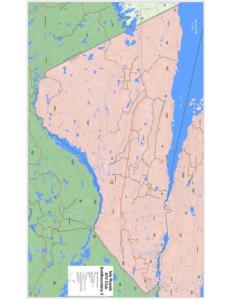
56
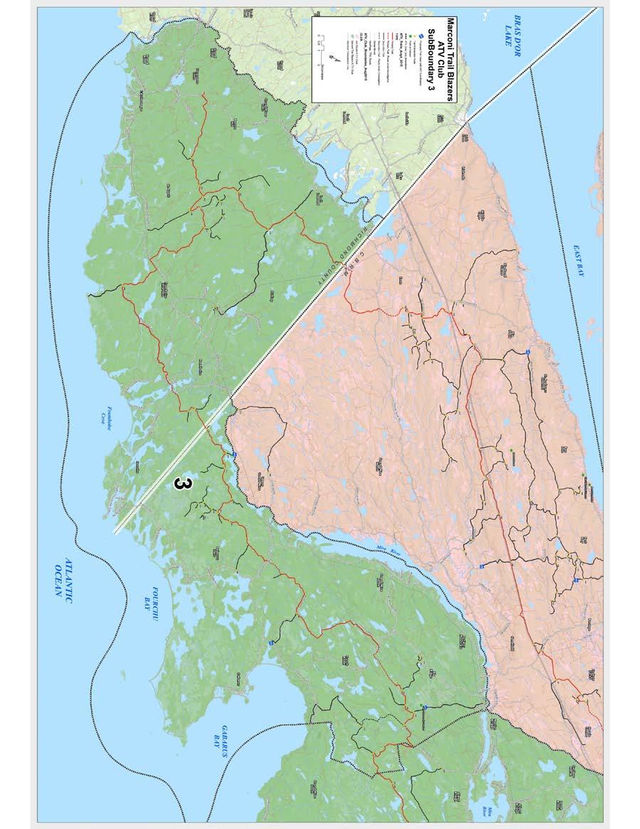
57
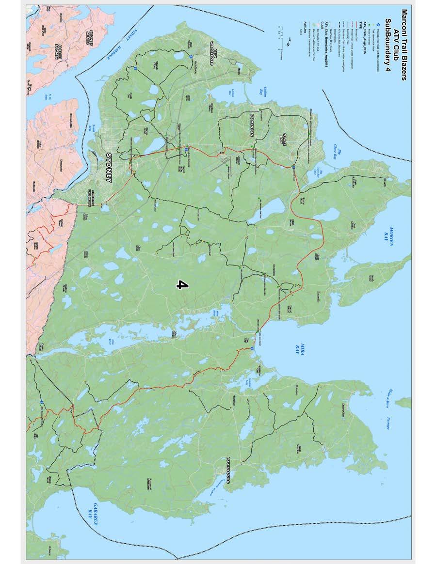
58

59 Appendix 4
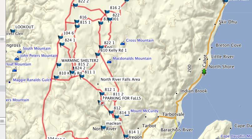
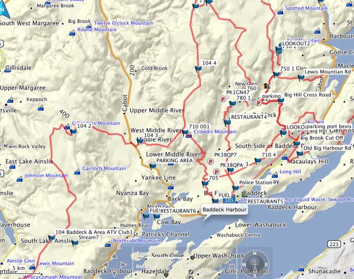
60
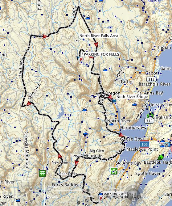
61
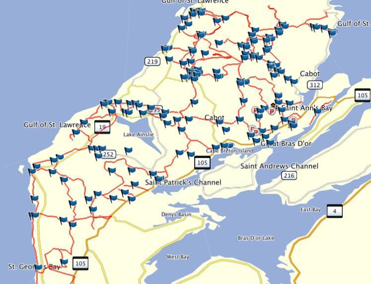
62
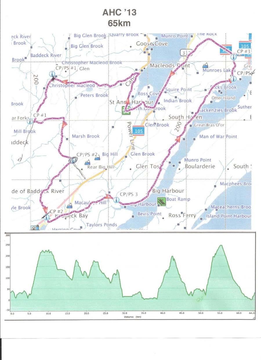
63
64 January 19, 2016 Cape Breton Trail Review and Inventory-Draft Report Dated January 2016 Market Readiness In reviewing the Market Readiness of trails, the consultants highlight Snowmobile Tourism as being mature in Cape Breton. Of course, this relates to the Highlands area with connections to communities such as Margaree, Whycocomagh, and Baddeck. In reality, Cheticamp, North River, and other communities with any ties to the Highlands can also be considered in relation to this sport and it s potential. What seems to be missing is the reality that all or most of the trails used by Snowmobilers in the winter months are shared and used by ATV s as soon as the snow is gone or no longer suitable for snowmobilers and not used by snowmobilers until the snow is again plentiful often in January. These shared trails are then available to ATV Riders to enjoy and explore the Highlands which provides a totally different perspective of these areas. The maps produced by the Snowmobile organization are for the most part, equally adapted for ATV Riders. The one issue that would have to be addressed is the signage situation where the Snowmobilers remove them in the summer and return them in late fall. The reason for such action is to protect the signs from those who might steal them or damage them. There are ways to work this out between the two groups and in particular since many Snowmobilers also ride ATV s. In like manner, the consultants, due to costs and time constraints were not able to actually visit ATV Trails in the Industrial Area and could only take a quick look at a couple of Trail Heads and discuss the shortfalls of local trails. One of the biggest shortfalls being the lack of signage. Maps are under production and for sure, all of the GIS information is available at the Club level but, not at the moment available to others. That will change as we move forward. However, in spite of the foregoing, there are opportunities now for attracting ATV Riders to Cape Breton to spend time ATVing in some fantastic areas. As noted on the GO Riding Video, great scenery, great people, great opportunities to take in other attractions during an ATV Riding vacation. Possibilities could be as follows: Offering a package for ATV Riders that would include First night of accommodations in the Nyanza area or Baddeck or Saint Ann s Next morning leave for Wreck Cove, tour the Highlands including the flowage sites, Cape Clear and travel over the mountain into Margaree. Stay a night at the Normaway or Cranton s Cottages, Next morning leave Margaree and travel to Cheticamp, tour this area and see lots of sites with tremendous views and depart area back to Wreck Cove. 1
65 From Wreck Cove, visitors would again stay overnight in the area or, perhaps leave and go to other locations to visit Graham Bell Museum, head towards Sydney and on to Louisbourg etc. Costs would include, accommodations, food, fuel, Trail Guide (highly recommended in the Highlands) Such a package would require at least three nights of accommodations. But, it is possible to offer shorter trips with fewer nights or a variety of alternate trails such as from Middle River into the Highlands or over to Lake Ainsley and then into the Highlands for either a one or two-day trip. It all depends on what is the most attractive for visitors. Similar trips can easily be organized in the CBRM on the trails, once again, signage is an issue at this time. But soon the maps will be available that will assist greatly for visitors who wish to take an ATV vacation. Other possibilities could include starting out at the Normaway Inn or Cranton Cottages and one day go into Cheticamp and return and another day, up into the Highlands on a second day and back to the Normaway or Cranton Cottages. Meals at these facilities, fuel, box lunches plus directions and a guide could easily be arranged. The foregoing is just a sample of what is possible in relation to ATV Vacations in Cape Breton. Guides are available, accommodations are also in place as is fuel, food and lots of great scenery and experiences. The only thing required is for someone or several someone s to organize these events. We frequently receive s or phone calls seeking information about ATV travel especially in the Highlands. When we host ATV Runs into this area and we send out information to other ATV Clubs in the province, it is not uncommon to have ATV enthusiasts join in the fun. 2
66 Type Location Name Citations (see report) National Park CBHNP Middle Head PC, HCB, MH, VCHT, Mb, TNS, HtH, VT, DCB, NG, T, TP 12 " CBHNP Fishing Cove PC, HCB, MH, Mb, TNS, HtH, ENS, VT, DCB, T, TP 11 " CBHNP Franey PC, HCB, MH, VCHT, Mb, TNS, HtH, VT, DCB, T, TP 11 " CBHNP Skyline PC, HCB, MH, Mb, TNS, HtH, VT, DCB, T, TP 10 " CBHNP Salmon Pools PC, HCB, MH, Tp, TNS, NG, VT, DCB, T 9 " CBHNP Aspy PC, HCB, MH, TNS, DCB, VT,HtH, ENS, TP 9 " CBHNP Warren Lake PC, HCB, VCHT, Mb, TNS, HtH, VT, DCB, T 9 " CBHNP Clyburn Valley PC, HCB, VCHT, TNS, NG, VT, DCB, T, TP 9 NSPP Uisage Ban Falls HCB, MH, VCHT, Mb, TNS, ENS, VT, T, TP 9 " Cape Smokey HCB, MH, VCHT, Mb, TNH, HtH, VT, T, TP 9 Community VC North River Falls HCB, MH, VCHT, Mb, TNS, TP, ENS, VT, T 9 " IC Celtic Shores Trail HCB, MH, Mb, TNS, ENS, VT, DCB, T, NG 9 National Park CBHNP Coastal PC, HCB, MH, VCHT, TNS, VT, DCB, T 8 " CBHNP Branch Pond Look-off PC, MH, VCHT, TNS, HtH, VT, DCB, T 8 Community VC White Point MH, VCHT, Mb, TNS, DCB, VT, T, TP 8 " VC Money Point HCB,MH, VCHT, HtH, NG, VT, T, TP 8 National PC, HCB, MH, Mb, TP, TNS, VT, Park CBHNP Acadian DCB 7 " CBHNP Jack Pine PC, MH, VCHT, TNS, HtH, VT, DCB 7 " CBHNP Freshwater Lake PC, VCHT, TNS, HtH, VT, DCB, TP 7 " CBHNP Le Buttereau PC, HCB,MH, TNS, HtH, VT 6 " CBHNP Corney Brook PC, TNS,, EBS, VT, DCB, T, TP 6 " CBHNP MacIntosh Brook PC, TNS, HtH, ENS, VT, DCB 6 " CBHNP Jigging Cove PC, VCHT, TNS, HtH, VT, DCB 6 " CBHNP Broad Cove Mountain PC, VCHT, TNS, HtH, VT, DCB 6 NSPP Whycocomagh Provincial Park: Salt Mountain Trail Mb, TNS, DCB, VT, T, TP 6 Community CBRM Winging Point, Gull Cove, Belfry Gut MH, Mb, TNS, VT, T, TP 6 " CBRM Louisbourg Lighthouse HCB,NST, MH, VT, T, TP 6 " CBRM Coxheath Trail CBRM, MH, Mb, NG, VT, T 6 " VC Sugarloaf Trail HCB, MH, Mb, VT, T, TP 6 " IC Meat Cove/Lowlands Cove DCB, Hth, ENS, MH, VT, T, TP 6 " IC Roberts Mountain HCB, MH, Mb, HtH, VT, T 6 " IC Cape Mabou Highlands HCB, MH, Mb, NG, VT, T 6 National Park CBHNP Le vieux chemin du Cap-Rouge PC, HCB, MH, VT, DCB 5 " CBHNP Bog PC, TNS, VT, DCB, TP 5 " CBHNP Benjie's Lake PC, TNS, VT, DCB, TP 5 " CBHNP Lone Shieling PC, Mb, ENS, VT, DCB 5 " CBHNP Glasgow Lakes Extension PC, VCHC, HtH, VT, DCB 5
67 CBHNP Freshwater Lake Look-off PC, VCHT, TNS, VT, DCB 5 Community VC Cape Dauphin HCB, VCHT, Mb, VT, TP 5 " VC Red Island HCB, MH, HtH, VT, T 5 " IC Meat Cove Mountain VCHC, Mb, DCB, VT, TP 5 " IC Pollett s Cove MH, HtH, NG, T, TP 5 " IC Egypt Falls HCB, Mb, ENS, VT, T 5 National Park CBHNP Le Chemin du Buttereau PC, TNS, DCB, VT 4 " CBHNP Green Cove PC, VCHT, VT, DCB 4 Point NSPP Michaud HCB. MH, VT, T 4 NSPP Ben Eoin Mb, TNS, VT, TP 4 Community RC Port Hawkesbury Community Trail MH, TNS, VT, T 4 " RC St Peters Coastal Trail HCB, TNH. VT, T 4 " RC Cape Auguet HCB, Mb, NST, TP 4 " RC Capelin Cove HCB, MH, VT, T, TP 4 " CBRM East Bay Hills Trail CBRM, Mb, TNS, VT 4 " VC Bald Mountain HCB, VCHT, Mb, VT 4 " VC Tenerife Mountain TP, VCHT, HtH, VT 4 " CBHNP Mica Hill HCB, VCHT, TNS 3 " LNHS Mi'kmaw Trail PC, HNS, VT 3 : LNHS Simon Point Trail PC, Mb, VT 3 NSPP Battery park NSP, MH, VT 3 Petersfield NSPP Park Mb, TNS, VT 3 NSPP Dalem Lake CBRM, TNS, VT 3 NSPP Cabot Landing Beach VCHT, HtH, VT 3 Community RC Pringle Mountain HCB, Mb, VT 3 " CBRM Kennington Cove HCB,NST, VT 3 " CBRM Gooseberry Cove HCB, Mb, VT 3 " CBRM Cape Breton trail MH, NST, VT 3 " CBRM Two Rivers Wildlife Park MH, NST, VT 3 " CBRM Moque Head Mb, VT, TP 3 " CBRM Barrachois Mountain Gorge HCB, VT, Mb 3 " VC Kelly s mountain Trail HCB, TNS, VT 3 " IC Gypsum Mine Mb, TP, VT 3 " IC Lewis Mountain Trail Mb, NG, T 3 " IC Two Rivers Wildlife Park Trail MH, TNS, VT 3 " IC Denys River MH, NG, T 3 " LNHS Lighthouse Trail PC, Mb 2 NSPP Barrachois CBRM, Mb 2 NSPP Plaster Provincial Park TNS, VT 2 Community RC Framboise Beach MH, T 2 " RC Little River Reservoir MH, VT 2 " RC Fox Cove Mb, VT 2
68 " CBRM Frenchvale Brook Trail CBRM, VT 2 " CBRM Whitney Pier CBRM, VT 2 " CBRM Devils Hill falls Mb, VT 2 " CBRM Baille Ard Trails Mb, VT 2 " CBRM Island View Falls/MacIntosh Falls Mb, VT 2 " CBRM Cowbay Road Trail VT, TNS 2 " CBRM Old Branch Road NG, VT 2 " VC St Anne Bay Trail NST, VT 2 " VC Devil's Hills Falls MB, VT 2 " IC Little Grassy Trail Mb, VT 2 " IC Eagles nest Trail TNS, VT 2 " IC Broad Cove Chapel MH, VT 2 " LNHS Old Town trail PC 1 " LNHS Royal Battery Trail PC 1 " LNHS Wolfs Redoubt Trail PC 1 " LNHS Ruins Walk PC 1 NSPP Lennox VT 1 NSPP Mira River VT 1 NSPP Lake O'Law VT 1 Community RC Delorier Island VT 1 " RC Cape George VT 1 " CBRM Munroe Park CBRM 1 " CBRM Indian Beach CBRM 1 " CBRM Sydney Boardwalk CBRM 1 " CBRM Wentworth Park CBRM 1 " CBRM Open Hearth Park CBRM 1 " CBRM Bill Davis Trail CBRM 1 " CBRM John Bernard Croak CBRM 1 " CBRM Scotchtown Summit Park CBRM 1 " CBRM Renwick Park Walking Path CBRM 1 " CBRM Big Lorraine Harbour VT 1 " CBRM Main-a-Dieu boardwalk VT 1 " CBRM South Head trail VT 1 " CBRM Cape Perce Mb, VT 1 " CBRM Schooner Pond Cove VT 1 " CBRM Goat Island Trail CBRM 1 " VC Frenchvale Brook Walking Trail VT 1 " VC Ross Ferry Trail VCHT 1 : VC Blackhead Road HCB 1 " VC Boiler Trail VCHT 1 " IC Cheticamp River Beach VT 1 " IC Big Interval Trail VT 1 " IC Inverness beach VT 1
69 " IC MacFarlane Woods VT 1 " IC Chestico VT 1 " IC Marble Mountain VT 1 " IC Logans Glen Falls VT 1 " IC Campbells Mountain Look-off VT 1 " IC Ghost Beach T 1
70
71 BLUE ROUTE VISION The Blue Route is a province-wide bicycling network that connects communities in all 18 counties and links local Active Transportation networks ~3000km of connected bicycle routes designated on road, streets, and trails

72 If 10% of Canadians moved more, Canada could save $2.5B in healthcare costs, and inject $7.5B into the national economy by 2040 Average ownership and operating costs of personal vehicles is $10,000/yr Cycling in Halifax, Agricola St.
73 Active Transportation facilities improve quality of life and make communities more attractive Property next to AT greenways consistently sells for more Halifax Urban Greenway

74 Outdoor enthusiasts spend $110 more per day on average in Nova Scotia La Route Verte generates $134M annually and supports 200 jobs Cycling in Halifax, Rocky Lake Rd.

75 Bicycling accounts for 74% of the $2.7M generated annually by PEI s Confederation Trail In Greenville, SC, businesses adjacent to the Swamp Rabbit Trail reported 10-85% sales increases 3 years after the trial opened Celtic Shores Coastal Trail, Inverness Cape Breton

76 GAINING MOMENTUM o 2007, Quebec launches the Route Verte o 2007, NS Bike Summit asks why not here? o 2009, BNS begins feasibility studies and consultations o 2013, Blue Route included in Sustainable Transportation Strategy + TIR takes lead in government o 2015, 1 st Blue Route Segment opens in Nova Scotia Cycling the Cabot Trail

77 FUNDING AND PARTNERSHIP o The Blue Route currently is being funded through existing programs o Since 2009, BNS has brought together resources to advance the Blue Route o Application pending at ACOA, for $800,000 - largest ask to-date o BNS seeks to align the Blue Route with other initiatives, i.e. TCT, municipal projects, Destination Trails. Guysborough Waterfront

78 M A R K E T I N G A N D C O M M U N I C AT I O N S blueroute.ca

79 BLUE ROUTE CONCEPT PLAN (DRAFT) Trails Trails 15% 15% Paved Shoulders Paved Shoulders 41% 41% Low Traffic Routes Low Traffic Routes 44% 44%


80 ROUTE TYPES o PAVED SHOULDERS o AADT is greater than 1000 vehicles/day o Width depends on traffic volume and speed; range from m Image showing temporary sign

81 ROUTE TYPES o SHARED ROADWAYS o AADT is less than 1000 vehicles/day o o Low truck volume Primarily rural areas Image showing temporary sign

82 ROUTE TYPES o TRAILS o Shared use and/or Greenways o Compact surfaces adequate for touring bicycle o Surfaces and widths appropriate for context and user mix Image showing temporary sign

83 ROUTE TYPES o BIKE LANES AND LOCAL STREET ROUTES o Standard bike lane should be 1.5m-1.8m wide o Local street routes are low speed and low traffic volume, may include traffic calming and/or diversion strategies Image showing temporary sign


84 ROUTE DESIGNATION Working Process o Designation determined by the Blue Route Team - through collaborative planning process o Implementation is the responsibility of the local authority - province, municipality, or non-profit o Funded through existing programs BLUE ROUTE SIGN, INSTALLED BY TIR

85 Blue Route Implementation Project: Pictou - Truro (East Mountian/Bible Hill) Jitney Trail - Route Trunk 4 Jitn Trail ey 376 Route 4 Trunk Trunk 4 Exit 16 ROUTES Blue Route On Provincial Road Blue Route On Jitney Trail Bicycle Nova Scotia ROUTE DESCIPTION Trunk 4, Truro - Exit 19: Provincial Highway, no paved shoulders, AADT <1000 Lenght: 32km Trunk 4, Exit 19 - Route 376: Provincial Highway, paved shoulders, AADT >1000 Length: 5km Route 376: Provincial Highway, paved shoulders, AADT >1000 Length: 16km Jitney Trail: Shared Use Trai, hard surface - paved and unpaved Length 3.3km

86 ROUTE OPENING AUGUST 6TH 2015!
87 NEXT STEPS ROUTING o o Stakeholder input, especially on trails and through municipalities Define and document the decision making process PLANNING FOR FUTURE PIECES o o o TIR Capital Repaving Plan identify links requiring upgrades On repaving contracts, not maintenance paving Finding links for next 2-3 years (routes near readiness)
88
TRAILS WHERE TO FIND TRAILS IN NOVA SCOTIA
 TRAILs SIGNAGE Know the Signs............................ 44 WHERE YOU CAN RIDE Roads and Highways........................ 46 Designated Trails........................... 47 Established Trails...........................
FINAL TESTIMONY 1 COMMITTEE ON RESOURCES UNITED STATES HOUSE OF REPRESENTATIVES. July 13, 2005 CONCERNING. Motorized Recreational Use of Federal Lands
 FINAL TESTIMONY 1 STATEMENT OF DALE BOSWORTH CHIEF Of the FOREST SERVICE UNITED STATES DEPARTMENT OF AGRICULTURE Before the SUBCOMMITTEE ON FORESTS AND FOREST HEALTH And the SUBCOMMITTEE ON NATIONAL PARKS,
Blueways: Rivers, lakes, or streams with public access for recreation that includes fishing, nature observation, and opportunities for boating.
 Parks, Open Space and Trails PRINCE WILLIAM COUNTY 2008 COMPREHENSIVE PLAN TRAILS PLAN CONTENTS The components of the trails plan are: Intent Definitions Goals, Policies, and Action Strategies Trails Map
Nova Scotia Visitor Exit Survey Community Report
 Nova Scotia Visitor Exit Survey Community Report Prepared dfor: Nova Scotia Department of Economic and Rural Development and Tourism October 2011 Page 1 Introduction This report presents the results ofthe
Off Highway Vehicle Infrastructure Fund Fiscal year Summary Report
 Off Highway Vehicle Infrastructure Fund Fiscal year 2014 Summary Report June 2015 Introduction The Off-highway Vehicle Infrastructure Fund (the Fund) was established as a result of recommendations of the
Economic Development and Tourism
 SECTION 4 SECTION 4 Economic Development and Tourism 4. Economic Development and Tourism Tourism plays a very important role in Niagara s economy, providing employment and generating business for support
Marchand Provincial Park. Management Plan
 Marchand Provincial Park Management Plan 2 Marchand Provincial Park Table of Contents 1. Introduction... 3 2. Park History... 3 3. Park Attributes... 4 3.1 Natural... 4 3.2 Recreational... 4 3.3 Additional
13.1 REGIONAL TOURISM ISSUES AND SUMMARY OF FINDINGS
 13 REGIONAL TOURISM T he County of Mariposa s recreation needs and facilities fall within two categories: regional tourism and local recreation. This Element focuses on regional tourism issues related
Clearwater Lake Provincial Park. Draft Management Plan
 Clearwater Lake Provincial Park Draft Management Plan Clearwater Lake Provincial Park Draft Management Plan Table of Contents 1. Introduction... 3 2. Park History... 4 3. Park Attributes... 4 3.1 Location/Access...4
Victoria County Tourism Strategy Presentation to Municipal Council
 2017, Group ATN Consulting Inc. Victoria County Tourism Strategy Presentation to Municipal Council Delivered by Group ATN - Stephen Coyle & Thomas McGuire May 29, 2017 1 Benefits of a Tourism Strategy
Committee. Presentation Outline
 CW-33-15 11/9/2015 Community and Corporate Services Committee November 10, 2015 1 Presentation Outline Background Vision and Objectives Study Process and Timeline Public and Stakeholder Engagement Organization
Longmont to Boulder Regional Trail Jay Road Connection DRAFT FINAL REPORT
 Longmont to Boulder Regional Trail Jay Road Connection DRAFT FINAL REPORT December 2018 Project Summary Boulder County, Colorado, in partnership with the City of Boulder, is evaluating options for multi-use
MANAGEMENT DIRECTION STATEMENT June, 1999
 Thompson River District MANAGEMENT DIRECTION STATEMENT June, 1999 for Roche Lake Provincial Park Ministry of Environment Lands and Parks BC Parks Division Table of Contents I. Introduction A. Setting
Clam Harbour Provincial Park
 Clam Harbour Provincial Park Public Engagement Session Thursday, September 14 th, 2017 5:30pm 7:30pm Webbers Store 11470 Nova Scotia Trunk 7 Lake Charlotte, NS Agenda Overview of the Provincial Parks System
Proposal to Redevelop Lower Kananaskis River-Barrier Lake. Bow Valley Provincial Park
 Frequently Asked Questions Proposal to Redevelop Lower Kananaskis River-Barrier Lake Bow Valley Provincial Park Frequently Asked Questions What has been decided? What are the details of the plan? What
NOVA SCOTIA TOURISM ICONS. July 2018 Tourism Nova Scotia
 NOVA SCOTIA TOURISM ICONS July 2018 Tourism Nova Scotia 1 BACKGROUND Initial research was undertaken in 2013, recognizing that iconic destinations and attractions are important catalysts for tourism, and
A GUIDE TO MANITOBA PROTECTED AREAS & LANDS PROTECTION
 A GUIDE TO MANITOBA PROTECTED AREAS & LANDS PROTECTION Manitoba Wildands December 2008 Discussions about the establishment of protected lands need to be clear about the definition of protection. We will
APPENDIX. Alberta Land Stewardship Act AMENDMENTS TO THE SOUTH SASKATCHEWAN REGIONAL PLAN
 APPENDIX Alberta Land Stewardship Act AMENDMENTS TO THE SOUTH SASKATCHEWAN REGIONAL PLAN 1 All references to Alberta Environment and Sustainable Resource Development, Environment and Sustainable Resource
As outlined in the Tatshenshini-Alsek Park Management Agreement, park management will:
 Management Strategy General Strategy The priority management focus for the park is to ensure that its internationally significant natural, cultural heritage and recreational values are protected and that
Establishing a National Urban Park in the Rouge Valley
 STAFF REPORT ACTION REQUIRED Establishing a National Urban Park in the Rouge Valley Date: March 29, 2012 To: From: Wards: Reference Number: Executive Committee Deputy City Manager, Cluster B All p:\2012\cluster
Continental Divide National Scenic Trail Legislative History and Planning Guidance
 Continental Divide National Scenic Trail Legislative History and Planning Guidance Legislation, Policy, and Direction Regarding National Scenic Trails The National Trails System Act, P.L. 90-543, was passed
WELCOME TO THE CAPE BRETON REGIONAL MUNICIPALITY (CBRM)
") WELCOME TO THE CAPE BRETON REGIONAL MUNICIPALITY (CBRM) 1-902-427-7788 OR TOLL FREE 1-888-753-8827 (24/7) CAPE BRETON SITE: (902) 563-7100 EXT 7107 WWW.CBRM.NS.CA The Cape Breton site of the Halifax &
WELCOME TO THE CAPE BRETON REGIONAL MUNICIPALITY (CBRM) 1-902-427-7788 OR TOLL FREE 1-888-753-8827 (24/7) CAPE BRETON SITE: (902) 563-7100 EXT 7107 WWW.CBRM.NS.CA The Cape Breton site of the Halifax &
Atlantic Treasures Self Drive 6N/7D
 Atlantic Treasures Self Drive 6N/7D Day 01 Halifax Arrive Halifax Airport, pick-up the vehicle from car rental agency and proceed to hotel located in the downtown core of this vibrant and cosmopolitan
FEASIBILITY CRITERIA
 This chapter describes the methodology and criteria used to evaluate the feasibility of developing trails throughout the study areas. Land availability, habitat sensitivity, roadway crossings and on-street
3.0 LEARNING FROM CHATHAM-KENT S CITIZENS
 3.0 LEARNING FROM CHATHAM-KENT S CITIZENS An important aspect in developing the Chatham-Kent Trails Master Plan was to obtain input from stakeholders and the general public. Throughout the course of the
City of Durango 5.8 FUNDING TRAILS DEVELOPMENT
 5.8 FUNDING TRAILS DEVELOPMENT The City has been successful in establishing dedicated local funding sources as well as applying for grants to develop the City s trail system, having received nearly $2.4
Georgetown-Lewes Rail/Trail Study. Rail/Trail Study: Cool Spring to Cape Henlopen State Park New Road Extension (House Resolution No.
 Georgetown-Lewes Rail/Trail Study Rail/Trail Study: Cool Spring to Cape Henlopen State Park New Road Extension (House Resolution No. 47) August 22, 2011 Presentation Outline Background Benefits Statewide
Strengthening the Ontario Trails Strategy. Report on Consultations and the Environmental Bill of Rights Registry
 Strengthening the Ontario Trails Strategy Report on Consultations and the Environmental Bill of Rights Registry Purpose To report on the feedback and information received through the regional consultations,
Restore and implement protected status that is equivalent, or better than what was lost during the mid-1990 s
 THE ROSSLAND RANGE, OLD GLORY AREA. Executive summary. The Friends of the Rossland Range Society, on behalf of the local outdoor community, seeks to accomplish the following with respect to the Old Glory
Proposal to Redevelop Lower Kananaskis River-Barrier Lake. Bow Valley Provincial Park. Frequently Asked Questions
 Proposal to Redevelop Lower Kananaskis River-Barrier Lake Bow Valley Provincial Park Frequently Asked Questions What is being proposed? What are the details of the proposal? Where is the project area located?
Ouimet Canyon Provincial Nature Reserve. Management Plan
 Ouimet Canyon Provincial Nature Reserve Management Plan NOTE: This document has been scanned and formatted, and therefore is slightly different from the original version. -March 2002 Additional copies
Chapter 6: POLICY AND PROCEDURE RECOMMENDATIONS
 Chapter 6 POLICY AND PROCEDURE RECOMMENDATIONS FOR SRRA Below are seven policy elements that should be considered for adoption by the Southwest Regional Recreation Authority of Virginia: 1. Develop strategies
VICTORIA COUNTY MUNICIPAL COUNCIL March 7, 2016
 VICTORIA COUNTY MUNICIPAL COUNCIL March 7, 2016 A meeting of Victoria County Municipal Council was held at the Court House, Baddeck, on Monday, March 7, 2016, beginning at 5:00 p.m. with Warden Bruce Morrison
MUNICIPALITY OF ANCHORAGE
 MUNICIPALITY OF ANCHORAGE ANCHORAGE PARKS & RECREATION Memorandum PRC 08-56 DATE: 5 August 2008 TO: FROM: SUBJECT: Parks & Recreation Commission Holly Spoth-Torres, Park Planner PRC 08-56 Far North Bicentennial
SUMMER VILLAGE OF SILVER SANDS. Municipal Development Plan
 SUMMER VILLAGE OF SILVER SANDS Municipal Development Plan Bylaw 253-2014 Adopted August 22, 2014 Summer Village of Silver Sands Municipal Development Plan Bylaw No. 253-2014 Page 2 1 INTRODUCTION 1.1 SETTING
Hermosa Area Preservation The Colorado Trail Foundation 4/11/2008
 Hermosa Area Preservation The Colorado Trail Foundation 4/11/2008 Legend d o Tr ail NPA - National Protection Area ra NCA - National Conservation Area o e C Th The Colorado Trail lo FS inventoried Roadless
April 10, Mark Stiles San Juan Public Lands Center Manager 15 Burnett Court Durango, CO Dear Mark,
 Mark Stiles San Juan Public Lands Center Manager 15 Burnett Court Durango, CO 81301 Dear Mark, We are pleased to offer the following comments on the draft San Juan Public Lands Center management plans
Preferred Recreation Recommendations Stemilt-Squilchuck Recreation Plan March 2018
 Preferred Recreation Recommendations Stemilt-Squilchuck Recreation Plan March 2018 Below are the recommended recreation ideas and strategies that package together the various recreation concepts compiled
A Master Plan is one of the most important documents that can be prepared by an Airport.
 The Master Plan A Master Plan is one of the most important documents that can be prepared by an Airport. A Master Plan is a visionary and a strategic document detailing planning initiatives for the Airport
AGENDA ITEM 5 D WAKULLA ENVIRONMENTAL INSTITUTE (WEI) TRAIL FEASIBILITY STUDY
 TRAIL FEASIBILITY STUDY") March 19, 2018 AGENDA ITEM 5 D WAKULLA ENVIRONMENTAL INSTITUTE (WEI) TRAIL FEASIBILITY STUDY TYPE OF ITEM: Action STATEMENT OF ISSUE The Wakulla Environmental Institute (WEI) Trail is one of several trails
March 19, 2018 AGENDA ITEM 5 D WAKULLA ENVIRONMENTAL INSTITUTE (WEI) TRAIL FEASIBILITY STUDY TYPE OF ITEM: Action STATEMENT OF ISSUE The Wakulla Environmental Institute (WEI) Trail is one of several trails
National Recreation Trail Update Form
 National Recreation Trail Update Form Introduction Thank you for taking the time to complete this form. Your assistance will help ensure that the National Recreation Trail (NRT) database is complete and
Item No Halifax Regional Council April 10, 2018
 P.O. Box 1749 Halifax, Nova Scotia B3J 3A5 Canada Item No. 14.3.2 Halifax Regional Council April 10, 2018 TO: SUBMITTED BY: Mayor Savage and Members of Halifax Regional Council Original Signed Councillor
Trails Classification Steering Team Alberta Tourism, Parks and Recreation Alberta Sustainable Resource Development Alberta TrailNet Society
 Acknowledgements Alberta Recreation Corridor and Trails Designation Program Alberta Recreation Corridors Coordinating Committee Trails Classification Steering Team Alberta Tourism, Parks and Recreation
Overview of the Business Plan 2007 to Shubenacadie Canal Commission
 Overview of the Business Plan 2007 to 2016 Shubenacadie Canal Commission November 2006 Briefly stated The Shubenacadie Canal was begun almost 200 years ago as an industrial engine for the new colony. It
BACKCOUNTRY TRAIL FLOOD REHABILITATION PROGRAM
 BACKCOUNTRY TRAIL FLOOD REHABILITATION PROGRAM Backcountry Trail Flood Rehabilitation A June 2013 Flood Recovery Program Summary In June 2013, parts of Southern Alberta were devastated from significant
IAT NS CAPE BRETON - NORTH SYDNEY TO PORT HASTINGS (SOUTHBOUND)
") NORTH SYDNEY TO GRAND NARROWS - 61.4 KM WELCOME TO NORTH SYDNEY, CAPE BRETON ISLAND, NOVA SCOTIA! North Sydney is a major city with a CAPs (public internet access) & all amenities. Rollies Wharf Restaurant
NORTH SYDNEY TO GRAND NARROWS - 61.4 KM WELCOME TO NORTH SYDNEY, CAPE BRETON ISLAND, NOVA SCOTIA! North Sydney is a major city with a CAPs (public internet access) & all amenities. Rollies Wharf Restaurant
KANANASKIS COUNTRY PROVINCIAL RECREATION AREAS MANAGEMENT PLAN DRAFT TERMS OF REFERENCE - November 20, 2007
 KANANASKIS COUNTRY PROVINCIAL RECREATION AREAS MANAGEMENT PLAN DRAFT TERMS OF REFERENCE - November 20, 2007 BACKGROUND There are 42 Provincial Recreation Areas (PRAs) within Kananaskis Country located
Appendix A BC Provincial Parks System Goals
 Appendix A BC Provincial Parks System Goals The British Columbia Provincial Parks System has two mandates: To conserve significant and representative natural and cultural resources To provide a wide variety
Policy PL Date Issued February 10, 2014
 Subject RENEWABLE ENERGY ON CROWN LAND Compiled by Renewable Energy Program, Biodiversity Branch Replaces Policy Directives Waterpower Site Release Crown Land Onshore Windpower Development - Crown Land
Thank you for the opportunity to comment on the proposed action to add trails and trailheads to the Red Rock District trail system.
 July 14, 2010 Jennifer Burns Red Rock Ranger District PO Box 20429 Sedona, AZ 86341 Flagstaff Biking Organization PO Box 23851 Flagstaff, AZ 86002 Dear Jennifer- Thank you for the opportunity to comment
Nova Scotia and Prince Edward Island 10 Days from $1395
 1 800 422 3727 Nova Scotia and Prince Edward Island 10 Days from $1395 Itinerary Day 1 Halifax, Nova Scotia Welcome to Canada s Atlantic Coast and the Canadian Maritimes, a land blessed with stunning natural
MANAGEMENT DIRECTION STATEMENT June, 1999
 Thompson River District MANAGEMENT DIRECTION STATEMENT June, 1999 for Clearwater River Corridor (Addition to Wells Gray Park) Ministry of Environment Lands and Parks BC Parks Division ii Table of Contents
RESEARCH AND PLANNING FORT STEELE HERITAGE TOWN VISITOR STUDY 2007 RESULTS. May 2008
 RESEARCH AND PLANNING FORT STEELE HERITAGE TOWN VISITOR STUDY 2007 RESULTS May 2008 Research and Planning Tourism British Columbia 300-1803 Douglas St. Box 9830 Stn. Prov. Gov t. Victoria, BC V8W 9W5 Web:
TOURISM & PUBLIC SERVICES RURAL SIGNAGE POLICY
 Policy and Procedures Subject Title: Tourism and Public Services Rural Signage Policy Corporate Policy (Approved by Council): X Policy Ref. No.: ROADS-01-07 Administrative Policy (Approved by CAO): By-Law
INFORMATION NOTICE 15-2 Limited & Excluded Lands
 INFORMATION NOTICE 15-2 Limited & Excluded Lands Schedule 1 (Land Description) of onshore petroleum Agreements issued by the Department of Energy details the total hectares calculated. Total hectares are
Tourism Development Plan for Scotland Questionnaire
 Draft National Tourism Development Plan Public Consultation 2013 Tourism Development Plan for Scotland Questionnaire We would like your views on this Plan and, in particular, your comments on opportunities
O REGON TRAILS SUMMIT. Oregon Trails Summit. Rogue River National Forest
 O REGON TRAILS SUMMIT Oregon Trails Summit 2014 Rogue River National Forest OREGON TRAILS 2015: A VISION FOR THE FUTURE The 2015-2024 Oregon Statewide Trails Plan Why do a trails plan? 2005-2014 Oregon
Criddle/Vane Homestead Provincial Park. Management Plan
 Criddle/Vane Homestead Provincial Park Management Plan 2 Criddle/Vane Homestead Provincial Park Table of Contents 1. Introduction... 3 2. Park History.... 3 3. Park Attributes.... 4 3.1 Natural.... 4 3.2
PROUDLY BRINGING YOU CANADA AT ITS BEST. Management Planning Program NEWSLETTER #1 OCTOBER, 2000
 PROUDLY BRINGING YOU CANADA AT ITS BEST VUNTUT NATIONAL PARK Management Planning Program NEWSLETTER #1 OCTOBER, 2000 INTRODUCTION This newsletter launches the development of the first management plan for
White Mountain National Forest Saco Ranger District
 United States Department of Agriculture Forest Service White Mountain National Forest Saco Ranger District 33 Kancamagus Highway Conway, NH 03818 Comm: (603) 447-5448 TTY: (603) 447-3121 File Code: 1950
A Vision for South Skunk River and Chichaqua Bottoms Greenbelt
 A Vision for South Skunk River and Chichaqua Bottoms Greenbelt Photo: Jim Pease Chichaqua Bottoms Booklet 7 of 8 Greater Des Moines Water Trails and Greenways 1 2016 Table of Contents Booklet 1: Water
National Recreation Trail Application for Designation
 National Recreation Trail Application for Designation Introduction Thank you for your interest in the National Recreation Trail (NRT) program. Completed NRT application packages must be submitted by December
Nova Scotia Tourism Agency Department of Economic and Rural Development and Tourism Statement of Mandate
 Nova Scotia Tourism Agency Department of Economic and Rural Development and Tourism Statement of Mandate 2014-15 Message from the Minister and the CEO Tourism is a key economic driver for communities throughout
4.0 Context for the Crossing Project
 4.0 Context for the Crossing Project This section provides background information about key features of the North Douglas Crossing project area, and opportunities and constraints. This information is important
Watchorn Provincial Park. Management Plan
 Watchorn Provincial Park Management Plan 2 Watchorn Provincial Park Table of Contents 1. Introduction... 3 2. Park History... 3 3. Park Attributes... 3 3.1 Natural... 4 3.2 Recreational... 4 3.3 Additional
Numaykoos Lake Provincial Park. Management Plan
 Numaykoos Lake Provincial Park Management Plan 2 Numaykoos Lake Provincial Park Table of Contents 1. Introduction... 3 2. Background... 3 3. Park Purpose... 5 4. Park Management Guidelines... 6 Appendix...
CHAPTER ONE LITERATURE REVIEW
 CHAPTER ONE LITERATURE REVIEW LITERATURE REVIEW This chapter summarizes the most recently published community impact studies and articles that relate to multiuse trails. The review focuses on publications
County of Peterborough Active Transportation Master Plan
 The TMP developed a conceptual AT/cycling network for Peterborough County that identified both on-road and off-road (trail) AT facilities. This was a coarse network based on the existing trails and off-road
Colorado Springs & Pikes Peak Region Destination Master Plan
 Colorado Springs & Pikes Peak Region Destination Master Plan Overview June 19, 2018 DESTINATION MASTER PLAN What is Destination Master Planning? Focus on infrastructure, facilities, services, attractions
Sasagiu Rapids Provincial Park. Draft Management Plan
 Sasagiu Rapids Provincial Park Draft Management Plan 2 Sasagiu Rapids Provincial Park Table of Contents 1. Introduction... 3 2. Background and Park Attributes... 3 2.1 Park History.... 3 2.2 Natural Features...
5.0 OUTDOOR RECREATION OPPORTUNITIES AND MANAGEMENT
 5.0 OUTDOOR RECREATION OPPORTUNITIES AND MANAGEMENT 5.1 Introduction This section describes the range of recreational activities that currently take place in Marble Range and Edge Hills Parks, as well
Project Planning, Compliance, and Funding
 Project Planning, Compliance, and Funding The plans above offer high level guidance to ensure that the A.T. is managed effectively as a whole unit in a decentralized management structure. Cooperative management
ONTARIO TRAILS COUNCIL FAQ
 Trail Facts Ontario has some of the most treasured and protected outdoor areas in the world with: 329 Provincial Parks 400 Conservation Areas 292 Conservation Reserves Many people link trails with recreation
Port Gamble Shoreline Area Conceptual Trail Proposal
 The North Kitsap Trails Association is pleased to be a partner to the Kitsap Forest and Bay Project and assist Kitsap County, Forterra, Olympic Property Group, Great Peninsula Conservancy and the Port
APPENDIX OFFICIAL MAP ORDINANCE OF HAMILTONBAN TOWNSHIP OFFICIAL MAP NARRATIVE
 APPENDIX A OFFICIAL MAP ORDINANCE OF HAMILTONBAN TOWNSHIP OFFICIAL MAP NARRATIVE INTRODUCTION: The Official Map of Hamiltonban Township has been prepared to identify those lands and features that Hamiltonban
Whitemouth Falls Provincial Park. Draft Management Plan
 Whitemouth Falls Provincial Park Draft Management Plan Whitemouth Falls Provincial Park Draft Management Plan Table of Contents 1. Introduction... 3 2. Park History... 3 3. Park Attributes... 4 3.1 Natural...
TOURISM NOVA SCOTIA BUSINESS PLAN
 TOURISM NOVA SCOTIA BUSINESS PLAN 2017-2018 TABLE OF CONTENTS MESSAGE FROM THE CHAIR & CEO 1 MANDATE 2 PLANNING CONTEXT 2 2017-2018 KEY ACTIVITIES 3 OUTCOMES AND PERFORMANCE MEASURES 6 FINANCIAL SUMMARY
TRAIL DATABASE SCHEMA (8/26/2014)
") Trail Data Model for LINES Source Data Source Agency dataagency Agency or entity that created the dataset where the original line was sourced from. Source Date of Last Data Used to Update sourcedate Publication
Trail Data Model for LINES Source Data Source Agency dataagency Agency or entity that created the dataset where the original line was sourced from. Source Date of Last Data Used to Update sourcedate Publication
Rating: 5.0 (scale of 1-10)
") 95 Community Trail System Groundcover: 2-metre paved path, 1- metre grass buffer on either side. Location: Fort St. John Ownership: City of Fort St. John Rating: 5.0 (scale of 1-10) Strategic value: Linear
95 Community Trail System Groundcover: 2-metre paved path, 1- metre grass buffer on either side. Location: Fort St. John Ownership: City of Fort St. John Rating: 5.0 (scale of 1-10) Strategic value: Linear
PURPOSE AND NEED. Introduction
 Public Scoping: Allocation of Recreation Capacity for Commercial Outfitter Guide Services on North Kruzof Island Trails (Kruzof Island Outfitter Guide) PURPOSE AND NEED Introduction The U.S. Department
Steps in the Management Planning Process
 Steps in the Management Planning Process Developing a management plan for Kalamalka Lake Park will follow a multi-stage process. The planning process for this park is currently in the Draft Management
IOW Ramblers Submission Paper to the Sept 2016 ROW Improvement Plan Consultation.
 IOW Ramblers Submission Paper to the Sept 2016 ROW Improvement Plan Consultation. The current Island Rights of Way Improvement Plan is a comprehensive document and much of its content is still relevant
Flow Stand Up Paddle Board Parkway Plan Analysis
 Regional Parks Department Jeffrey R. Leatherman, Director County of Sacramento Divisions Administration Golf Leisure Services Maintenance Rangers Therapeutic Recreation Services Flow Stand Up Paddle Board
Procedure for the Use of Power-Driven Mobility Devices on Mass Audubon Sanctuaries 1 September 17, 2012
 Procedure for the Use of Power-Driven Mobility Devices on Mass Audubon Sanctuaries 1 September 17, 2012 Background As part of Mass Audubon s mission to preserve the nature of Massachusetts for people and
Regional Wayfinding Sign Strategy Thurston County Trails 2017
 Regional Wayfinding Sign Strategy Thurston County Trails 2017 Partners: Members and partnering organizations of the Thurston Thrives Community Design Action Team City of Lacey, City of Olympia, City of
MARBLE RIVER PROVINCIAL PARK
 MARBLE RIVER PROVINCIAL PARK PURPOSE STATEMENT AND ZONING PLAN March 2003 MARBLE RIVER PROVINCIAL PARK Purpose Statement and Zoning Plan Primary Role The primary role of Marble River Park is to protect
Rule Governing the Designation and Establishment of All-Terrain Vehicle Use Trails on State Land
 Rule Governing the Designation and Establishment of All-Terrain Vehicle Use Trails on State Land 1.0 Authority 1.1 This rule is promulgated pursuant to 23 V.S.A. 3506. Section 3506 (b)(4) states that an
Park Design and Location Criteria
 Park Design and Location Criteria This section is presented in the interest of assisting park and recreation agencies in the development of a system of parks and recreation areas. A recreation system is
2. Goals and Policies. The following are the adopted Parks and Trails Goals for Stillwater Township:
 D. PARKS AND TRAILS 1. Introduction Stillwater Township s population is relatively low, with most residents living on rural residences on large lots. The need for active park space has been minimal in
DRAFT - APRIL 13, 2007 ROUTING STUDY FOR TRAIL CONNECTIONS BETWEEN CALAIS AND AYERS JUNCTION
 DRAFT - APRIL 13, 2007 ROUTING STUDY FOR TRAIL CONNECTIONS BETWEEN CALAIS AND AYERS JUNCTION Abstract The vision for the East Coast Greenway is an off-road urban trail system running from Calais, Maine
Appendix 3. Greenway Design Standards. The Whitemarsh Township Greenway Plan
 Appendix 3 Greenway Design Standards This chapter discusses two design standards for the greenway types discussed above. First, trail design standards are presented together with trailhead facilities and
Greater Minnesota Regional Parks and Trails Commission Designation Application
 Greater Minnesota Regional Parks and Trails Commission Designation Application General Section Designation Application #: 15-059D Date Submitted: 06/16/2015 Park or Trail Name: Mesabi Trail District #:
PROPOSAL FOR RECLASSIFICATION, BOUNDARY AMENDMENT AND DRAFT CONCEPT PLAN FOR SASKATOON MOUNTAIN NATURAL AREA. Frequently Asked Questions
 PROPOSAL FOR RECLASSIFICATION, BOUNDARY AMENDMENT AND DRAFT CONCEPT PLAN FOR SASKATOON MOUNTAIN NATURAL AREA 1. Why is this proposal being put forward? Frequently Asked Questions For many years, Alberta
Decision Memo Broken Wheel Ranch Equestrian Outfitter Special-Use Permit Proposed Action
 Decision Memo Broken Wheel Ranch Equestrian Outfitter Special-Use Permit USDA Forest Service Mississippi Bluffs Ranger District, Shawnee National Forest Jackson and Union Counties, Illinois Proposed Action
Chair and Members of Harbour East - Marine Drive Community Council. Brad Anguish, Director, Parks and Recreation
 P.O. Box 1749 Halifax, Nova Scotia B3J 3A5 Canada Item No. 15.1.1 Harbour East-Marine Drive Community Council December 3, 2015 TO: SUBMITTED BY: Chair and Members of Harbour East - Marine Drive Community
Florida National Scenic Trail 5-Year Strategic Plan. Barbara Bowen
 Florida National Scenic Trail 5-Year Strategic Plan 2012 Barbara Bowen Florida National Scenic Trail M. Timothy O Keefe M. Timothy O Keefe Mike Knox 20-mile Planning Corridor Florida National Scenic Trail
Park Board Chair and Commissioners
 TO: FROM: Park Board Chair and Commissioners April 21, 2017 General Manager Vancouver Board of Parks and Recreation SUBJECT: Water Bike Rental Service at Vanier Park Pilot Program Contract Award RECOMMENDATION
White Mountain National Forest Saco Ranger District
 United States Department of Agriculture Forest Service White Mountain National Forest 33 Kancamagus Highway Conway, NH 03818 Comm: (603) 447-5448 TTY: (603) 447-3121 File Code: 1950 Date: February 26,
PROPOSED PARK ALTERNATIVES
 8 Chimne y Rock State Park M a ster Pl an 2011 PROPOSED PARK ALTERNATIVES Introduction Three different park development concepts were prepared and presented to the citizens of North Carolina through a
F. Forest Recreation Management
 F. Forest Recreation Management F.1) Park and Recreation Management F.1.A. Program Overview. The park and recreation program has been in existence since 1980. With ever increasing outdoor recreation demands