HOAKALEI CULTURAL FOUNDATION STEWARDSHIP OF THE HONOULIULI PRESERVATION AREAS
|
|
|
- Maurice Tate
- 5 years ago
- Views:
Transcription
 serves as the steward of nearly 25 acres of land along the Honouliuli coastal zone.")
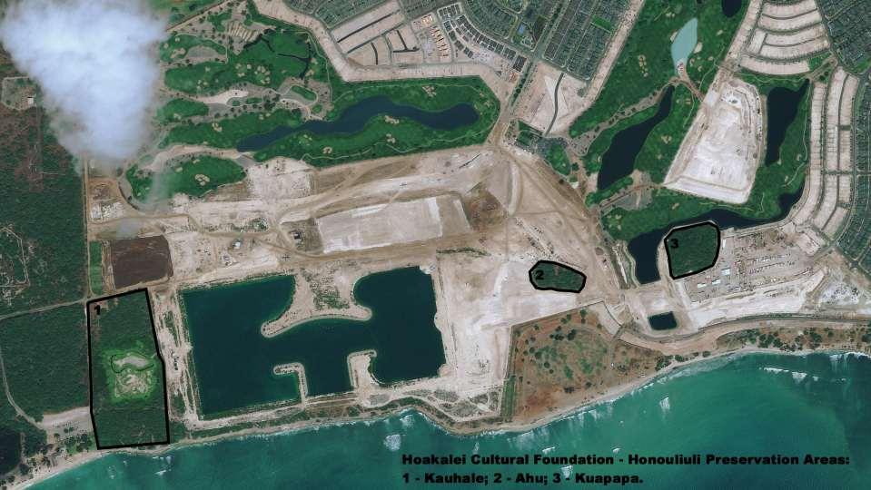
1 HOAKALEI CULTURAL FOUNDATION STEWARDSHIP OF THE HONOULIULI PRESERVATION AREAS Through an agreement between Haseko Inc. and the State of Hawai i, the Hoakalei Cultural Foundation (Hoakalei CF) serves as the steward of nearly 25 acres of land along the Honouliuli coastal zone. The land comprises three preservation areas which include traditional Hawaiian house sites, shelters, dryland agricultural features and walls; and historic structures including the ruins of a piggery and chicken farm. The preservation sites are now known as Kauhale, Ahu and Kuapapa (see figure depicting the three preservation areas on the land). Kupuna Eaton, Aunty Mary Serrao, members of the Hoakalei Cultural Foundation, community members, Archaeologists and UH-Education Students participated in a site trip in 2007 to discuss preservation and educational program development at the Kauhale Preserve. 1
2 2
3 Due to changes in long term land use practices as early as the mid 1800s, many of the sites and features on the land deteriorated over time. The traditional knowledge of place has also become fragmented. But through detailed research in native Hawaiian language accounts and historical records we are finding important histories recorded by elder Hawaiians of the 1800s to help answer some questions about life on the land. Further, the personal memories of kama āina of the land those who have lived in Honouliuli Ahupua a throughout their lives, helps us piece together facets of the history of shoreward Honouliuli. Today, some of the cultural sites ( archaeological features ) look like rubble piles, reflecting the impacts of more than 100 years of ranching (ca. 1850s to 1960), sugar plantation development (1890 to ca. 1970) and a period of military occupation and use of the land for training operations in the years prior to and following World War II. The Preservation Sites (1) The Kauhale Preserve includes traditional sites interpreted as having served as residences (with temporary/short term, and long term generational uses); dry land agricultural sites where crops such as uala (sweet potatoes), ipu/hue (gourds), kō (sugar cane), hala (pandanus) and other important plants for sustaining traditional life would have grown; workshop areas; and other features associated with daily life in ancient times. 3


4 2007 field trip to Kauhale Preserve with community members, University of Hawai i students, archaeologists and planners to discuss interpretive-educational program development. 4
, koloa (Anas wynvilliana) and alae kea (Fulica alai).")
5 The Kauhale Preserve also includes the remnants of a wetland feature, approximately 6.2 acres in area, and which is home to several endangered native water birds the kūkuluāe o (Himantopus mexicanus knudseni), koloa (Anas wynvilliana) and alae kea (Fulica alai). It is also likely that in Kūkuluāe o at home in the Kauhale Preserve Wetland. traditional times, when water resources were higher, the area would have been home to endemic ōpae (brackish water shrimp) and wetland plants. Based on native witness testimonies of the 1840s, it is safe to assume that the muddy flats around the wetland served as an important kula ālialia (salt making flatland) for people who fished and gathered limu along this section of the Honouliuli shoreline. 5

 have found a home in nearby new")
6 2007 field trip to wetland preserve to discuss interpretiveeducational program opportunities. While the actual wetland preserve is water stressed, the kūkuluāe o (Hawaiian stilts) have found a home in nearby new water features of the Hoakalei development. 6
 like these still used at")

7 The Pu uloa Slat Works in 1909 (USGS photograph). Loko pa akai (salt ponds) like these still used at Pū olo, Kaua i, are like ones that could be made as cultural demonstration sites within the Kauhale Preserve. 7
 wood. Because of these impacts, the integrity of these sites has been greatly compromised, and their function and form are uncertain.")
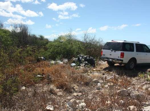
8 Below the wetland are found other sites which include an overlay of historic military debris, and which have been further impacted in recent times by their use for dumping rubbish, as makeshift camps, and in gathering introduced kiawe (Prosopis sp.) wood. Because of these impacts, the integrity of these sites has been greatly compromised, and their function and form are uncertain. The Hoakalei Culture Foundation is presently overseeing hand clearing of invasive kiawe overgrowth in the upper section of the Kauhale Preserve, and laying out an interpretive trail to help provide access to some of the cultural resources found in the area. Kauna oa and Pōhuehue were once common along the Honouliuli shoreline. As the Foundation develops interpretive wayside exhibits and documentary materials, these resources will provide students with opportunities for place based field programs. Such sites are within easy distance of community schools and area neighbor-hoods. By walking the land, participating in stewardship and outreach programs, our youth and members of the neighboring communities will explore their island history and be inspired to pass the legacy of the cultural landscape on to future generations. 8


9 Clearing kiawe overgrowth that has damaged sites is done by hand to ensure long term access and care of cultural resources of the Hoakalei preservation areas. Once cleared and stabilized, cultural sites will be monitored accessed through designated interpretive trails. 9
.")
10 (2) The Ahu Preserve contains one site with several possible contributing features. Most notable is the single most impressive feature in size and form of the three preservation areas (pictured at right). A platform of dry-stacked coral cobbles roughly 36 feet long, 32 feet wide, and 4 feet high. Based on early archaeological field work and form, it has been suggested that this site may have served some ceremonial purpose, as a place where prayers might have been offered to increase rainfall on the drier lowlands; or as a site where, though not immediately along the shore, it might also have served as a fisherman s shrine (heiau ko a). 10

11 The Ahu (Site No. 3209) is the largest and best preserved site found within the three preservation areas. The three preservation areas are home to sites which had the most integrity in form of any found during archaeological field work in the years prior to beginning development of the Haseko project. 11
 as their primary food sources, and like other areas of the drier Honouliuli coastal lands, exchanged their products with family")
12 (3) The Kuapapa Preserve contains several sites which supported both short and long-term recurring residency, possibly animal husbandry, and dryland agricultural activities. The people here relied upon the bounty of the ocean (fish and seaweeds) as their primary food sources, and like other areas of the drier Honouliuli coastal lands, exchanged their products with family members who lived inland where irrigated fields produced kalo and other important resources. House site in the Kuapapa Preserve. 12

13 Aerial photo (ca. 1960) of the Ewa Beach-Kalaeloa region. The locations of the wetland and Hoakalei preservation areas are seen along with the range of the sugar fields, the piggery and kiawe overgrowth. 13

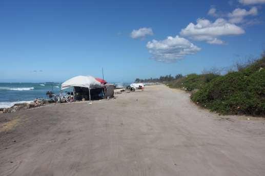
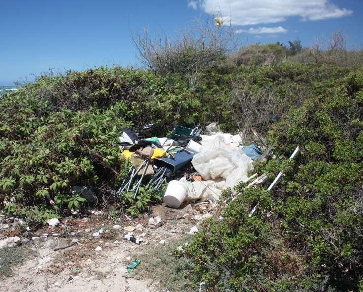
14 Within the boundaries of this preservation area are also found the remains of a modern pig farm. Aerial photographs from the early 1960s depict the pig farm sites, with corrugated roofing and cement foundations. 14
 where valued limu and aquatic resources are found.")
15 Programs of the Hoakalei Cultural Foundation (Hoakalei CF) extend beyond the preservation areas and research/outreach programs, to the shoreline where several endemic Hawaiian plants and cultural resources are found, and out to the papa (the near shore reefs) where valued limu and aquatic resources are found. Most recently, on June 4, 2012, Keiki to Kūpuna participated in an invasive seaweed removal program on the papa fronting One ula Beach Park, in partnership with Hoakalei CF, University of Hawai i marine resources specialists, and community members. 15

16 Kupuna Eaton shared personal recollections of life along the Pu uloa shoreline in the 1930s, with participants in the shoreline stewardship project on June 4,

17 The Hoakalei Cultural Foundation works to engage community youth, families and resource people in stewardship program to promote care wise use of our natural/cultural resources and to pass the legacy on to future generations. 17

18 HONOULIULI IS A STORIED LANDSCAPE Maiapilo (Capparis sandwichiana) is one of the plants that was traditional found along the Honouliuli shoreline, and one that will be brought back to the land through Foundation programs. That many changes have occurred on the land even over the last 25 years is clear to see. We will never know all the traditions, noted places and wahi pana of the landscape, nor all the people who walked the land. But through efforts of community stewardship, the land can share facets of its history, and also be home to new generations. The Hoakalei Cultural Foundation is dedicated to ensure that factual history and traditions which have time depth on the land and in the lives of the people who called Honouliuli home are known and passed on. It is hoped that with this knowledge coming from many hālau (schools), that we can together ensure wise use, respect and aloha for the āina (land) and kai (sea) of Honouliuli that this place will be cared for by all who call it home or tread upon the land. 18

19 Kingdom Register Map No. 405 Honouliuli Ahupua a (W.D. Alexander, 1873) 19

20 One ancient visitor to Ewa, the goddess Hi iaka, walked along the coastal flat lands of Honouliuli. Along the way, she gathered blossoms of plants now rare, which she made into lei for herself. It was from the Hawaiian language narrative that the name Hoakalei was relearned, and it is the source of the inspiration for the Hoakalei Cultural Foundation: Hi iaka continued down the trail and arrived at Kūalaka i. At Kūalaka i, the trail took her to a spring of cool water. Looking into the spring, she saw her reflection shining brightly upon the water s surface. Hi iaka also saw two lehua trees growing on each side of the spring. Now these two lehua trees were completely covered with blossoms. She then picked the lehua blossoms of these two trees and wove garlands for herself. A lehua blossom of the ōhi a from the dryland forest. These trees once grew down to the shoreline of Honouliuli. 20

21 Hi iaka made four strands for her lei, she then removed the garlands of ma o which she received when descending from Pōhākea, and set them aside. She then took the garlands which she had made, and adorned herself with them. Hi iaka then heard a voice calling out from the area of Kānehili: 21
22 O Hi iaka ka wahine Ke ako la i ka pua o Hoakalei Ke kui la, ke uo la i ka mānai Ehā ka lei, ka āpana lei lehua a ka wahine la Ku u pōki i Ku u pōki i mai ke ehu makani o lalo Lulumi aku la i ke kai o Hilo-one No Hilo ke aloha Aloha wale ka lei e Hi iaka is the woman Who picked the flowers of Hoakalei And with a needle strung and made them into Four garlands, the sectioned lei of the woman O my younger sibling My younger sibling who came from the place where the dusty wind rises from below Overturned in the sea of Hiloone The aloha is for Hilo Love for the lei 22
![That place, Hilo-one, which is mentioned in the mele [chant], is situated on the northern side of Kūalaka i, close to Kalaeloa.](/docs-images/89/99812539/images/23-1.jpg "And the name of the spring in which Hi iaka looked and saw her reflection was Hoakalei [Reflection of a lei].")
23 That place, Hilo-one, which is mentioned in the mele [chant], is situated on the northern side of Kūalaka i, close to Kalaeloa. And the name of the spring in which Hi iaka looked and saw her reflection was Hoakalei [Reflection of a lei]. It was at this place that Hi iaka saw the two lehua trees growing, from which she picked the blossoms to make her four garlands. [Nupepa Ka Hoku o Hawaii, Feb. 22, Kepā Maly, Translator.] Po opo o (sinkholes) like this one at Kalaeloa, provided ancient residents of the Honouliuli coastal lands with potable water perhaps like the spring, Hoakalei. Dry po opo o were used as planting areas, for refuges and other practices of old. 23
, the Hoakalei Cultural Foundation is working with Haseko Inc.")
24 THE SHORELINE AND COASTAL PLANTS: Naio, the false sandalwood (Myoporum stellatum) is unique, not found naturally anywhere else on earth, as this variety only grows at a few locations in Honouliuli Ahupua a. With the assistance of Rick Barboza (Hui Kū Maoli Ola), the Hoakalei Cultural Foundation is working with Haseko Inc., the State and City to ensure protection of this Hawaiian treasure, and to develop opportunities for out-plantings. The Honouliuli naio in bloom along the One ula shoreline
, aki aki (Sporobolus virginicus) and alena (Boerhaavia diffusa) occurs along one section of the One ula shoreline.")
25 A diverse plant community made up of naio (Myoporum stellatum), kou (Cordia subcordata), ilma (Sida fallax), ōhelo kai (Lycium sandwicense), aki aki (Sporobolus virginicus) and alena (Boerhaavia diffusa) occurs along one section of the One ula shoreline. 25

.")
26 Old growth naio (Myoporum stellatum) is found along the perched coral flats of One ula. Rick Barboza of Hui Kū Maoli Ola in the field along the One ula shoreline is engaged in helping Hoakalei Cultural Foundation (Hoakalei CF) identify Hawaiian plants growing on the coast. Here, documenting a patch of ākulikuli kai or ōhelo kai (Lycium sandwicense). 26
.")
27 Close up of ākulikuli kai or ōhelo kai (Lycium sandwicense). 27

28 Sadly, much of the One ula shoreline has become a dumping ground for all kinds of ōpala. This incredible shoreline wilderness falls under agency jurisdiction, and community members and organizations like the Hoakalei Cultural Foundation are coming together with land owners and agencies to help return it to its natural health, and as a place where all of the island community can feel safe. Good stewardship of the One ula-kūalaka i coastline is good for the land, sea, and people, and will enrich the lives of present and future generations. 28

29 29

30 30
31 31

32 The old military fence line separating the One ula coastline from the coastal stretch towards Kūalaka i. Discussions are being held to explore the possibility of removing this modern barrier, and once again, freely sharing the length of the shoreline with the public. Wise use and responsible stewardship of the resources will facilitate ease of access along this special coast. 32
33 HOAKALEI CULTURAL FOUNDATION E Hana Pono no ka Āina a me ka Ho oilina o Ewa Working to Ensure Good Stewardship of the Land and Heritage of the Ewa Plain To learn more about programs of the Hoakalei Cultural Foundation, and about ways to become involved in stewardship activities, please contact Kepā Maly. Aia no ke ola i ka hana a ka lima! (Life is there in working with one s hands!) Kepā Maly Executive Director kepa@hoakaleifoundation.org (find us on FaceBook as well) 33
Foundation Document Overview Pu uhonua o Hōnaunau National Historical Park
 NATIONAL PARK SERVICE U.S. DEPARTMENT OF THE INTERIOR Foundation Document Overview Pu uhonua o Hōnaunau National Historical Park Hawai i Contact Information For more information about the Pu uhonua o Hōnaunau
ONE ISLAND, FIVE NATIONAL PARKS
 FOR IMMEDIATE RELEASE Big Island Visitors Bureau Media Contact: Jessica Ferracane, (808) 895-5740, jessica@irondogpr.com ONE ISLAND, FIVE NATIONAL PARKS Hawai i Island (July 12, 2011) Hawai i, the Big
Pacific Missile Range Facility (PMRF) Cultural Landscape Report Final August Chapter 3 Historic Context
 Cultural Landscape Report Final August Chapter 3 Historic Context") SOURCE: Pacific Missile Range Facility (PMRF) Cultural Landscape Report Final August 2011 Introduction Chapter 3 Historic Context To the extent that it is relevant to archaeological and historical investigations
SOURCE: Pacific Missile Range Facility (PMRF) Cultural Landscape Report Final August 2011 Introduction Chapter 3 Historic Context To the extent that it is relevant to archaeological and historical investigations
KPA Study HiHETF116-Laupähoehoe (120506a)
") KPA Study HiHETF116-Laupähoehoe (120506a) HILO PALIKÜ HILO OF THE UPRIGHT CLIFFS: A Study of Cultural-Historical Resources of Lands in the Laupähoehoe Forest Section, Ahupua a of the Waipunalei-Mauluanui
KPA Study HiHETF116-Laupähoehoe (120506a) HILO PALIKÜ HILO OF THE UPRIGHT CLIFFS: A Study of Cultural-Historical Resources of Lands in the Laupähoehoe Forest Section, Ahupua a of the Waipunalei-Mauluanui
KAHANA VALLEY CULTURAL LIVING PARK
 KAHANA VALLEY CULTURAL LIVING PARK WAILUA AUWAI AND LO I Ahupua a o Kahana encompasses 5,260 acres boarded by Makali i Point to the north, Māhie Point on the south, Makaua, Waikāne and Punalu'u mauka,
Egypt and the Nile River Valley System. SC Standards 6-1.3, 1.4, 1.5
 Egypt and the Nile River Valley System SC Standards 6-1.3, 1.4, 1.5 Where is Egypt? Egypt is on the continent of Africa. The River Nile runs through Egypt The capital of Egypt is Cairo Where is Egypt?
Physical. and. Human-made. Features
 Directions for Making a Geographic Features Vocabulary Book 1. Cut the photographs boxes out of page 2 and sort the them into two groups: physical features and human-made features. 2. Correctly match each
Biodiversity is life Biodiversity is our life
 Biodiversity is life Biodiversity is our life Chapter 10 Section 2 Biodiversity at Risk Objectives Define and give examples of endangered and threatened species. Describe several ways that species are
Monterey Bay National Marine Sanctuary Southern Region
 Monterey Bay National Marine Sanctuary Southern Region Connecting Land and Sea - The interface of land and sea is unique, drawing people for its rich bounty, economic opportunity, recreation and inspiration.
Bon Portage Island Conservation Campaign
 Bon Portage Island Conservation Campaign Protecting a Coastal Treasure Final Report to Nova Scotia Habitat Conservation Fund September 2012 Protection of Bon Portage Island Over the course of this two-year
IMPACTS OF THE RECENT TSUNAMI ON THE BUNDALA NATIONAL PARK THE FIRST RAMSAR WETLAND IN SRI LANKA
 IMPACTS OF THE RECENT TSUNAMI ON THE BUNDALA NATIONAL PARK THE FIRST RAMSAR WETLAND IN SRI LANKA by C.N.B. Bambaradeniya, IUCN The World Conservation Union, Sri Lanka Country Office (Email: cnb@iucnsl.org)
IMPACT REPORT 38 6 $1.5M OUR STAFF PARK PARTNERS 2016 DONATIONS ENTENNIAL
 ENTENNIAL IMPACT REPORT 38 6 $1.5M OUR STAFF PARK PARTNERS 2016 DONATIONS WELCOME FROM THE BOARD CHAIR AND EXECUTIVE DIRECTOR Aloha käkou! Welcome to our 2016 annual report. It was a busy and productive
STORNETTA BROTHERS COASTAL RANCH
 STORNETTA BROTHERS COASTAL RANCH Location: Surrounding Point Arena Lighthouse and immediately south of Manchester State Park Mendocino Co., CA Acres: 1,860 Resources: Over two miles of Pacific Ocean coastline
Properties. Some of the last remaining mixed-use lots in the City of Kapolei Oahu, Hawaii 79B 79A 66B
 Properties 80 79A 79B 66B 63 59 65 61 64 Some of the last remaining mixed-use lots in the City of Kapolei Oahu, Hawaii West Oahu aerial Makakilo: 3,500 Hoopili: 11,750 Makaiwa Hills: 4,100 MAKAKILO DR
Unit 14: Kosrae: Lelu Stone Ruin. Tadasy Charlie
 Unit 14: Kosrae: Lelu Stone Ruin Tadasy Charlie Facts Government: Urban areas: Biggest Island: Independent (State of the Federated States of Micronesia- FSM) Lelu and Tofol Kosrae Highest Point:: Mount
a place of exceptional natural beauty
 Mission Beach a place of exceptional natural beauty Where the rainforest grows right down to the sea And where you have the best chance of seeing a cassowary in the wild Tourism is the main industry at
MAP KEY. BLACK CIRCLES: Our 3 trip destinations of Tulum, Progreso, and Hacienda Temozon in Merida.
 SPRING 2017 GLOBAL OUTREACH is the newest product to come from The SA Way s educational brand. It is part study abroad, part ecoadventure, focusing on Spanish language, ethical service learning, environmental
World Heritage Site 1. World Heritage Site 2 OCEANIA
 World Heritage Site 1 This site is managed by both the national government of this country in the southern hemisphere and the native people who have lived here for thousands of years. Tidal plains, lowlands,
An NPS Wetland of International Significance!
 An NPS Wetland of International Significance! A World Class Tourism Destination Linda Friar Chief of Public Affairs 305-242-7714 Linda_Friar@nps.gov The Everglades - International Recognition as a special
Hawai i Hotels Statewide Set New Annual Records in 2017 for Revenue Per Available Room and Average Daily Rate
 For Immediate Release: January 25, 2018 HTA Release (18-11) Hawai i Hotels Statewide Set New Annual Records in 2017 for Revenue Per Available Room and Average Daily Rate Statewide Average Daily Rate Rose
Pinellas County Environmental Lands
 Pinellas County Environmental Lands In addition to traditional parks and recreation facilities, Pinellas County owns and manages a system of environmental lands that provides specialized resource-based
Chapter 7 Geography and the Early Settlement of Egypt, Kush, and Canaan
 Chapter 7 Geography and the Early Settlement of Egypt, Kush, and Canaan How did geography affect early settlement in Egypt, Kush, and Canaan? Section 7.1 - Introduction RF/NASA//Corbis This satellite photograph
PUNA (Zone 1) Year Suggestion Form Submitted Tax Map Key(s)
 Year Suggestion Form Submitted Tax Map Key(s)") 1 COUNTY OF HAWAI I PUBLIC ACCESS, OPEN SPACE AND NATURAL RESOURCES PRESERVATION COMMISSION (PONC) COMPREHENSIVE LIST OF PROPERTIES SUBMITTED BY THE PUBLIC (DECEMBER 27, 2013) PUNA (Zone 1) 2006 2007 2008
1 COUNTY OF HAWAI I PUBLIC ACCESS, OPEN SPACE AND NATURAL RESOURCES PRESERVATION COMMISSION (PONC) COMPREHENSIVE LIST OF PROPERTIES SUBMITTED BY THE PUBLIC (DECEMBER 27, 2013) PUNA (Zone 1) 2006 2007 2008
Revenue Per Available Room for Hawai i Hotels Grew 5.5 Percent in November Hotel Occupancy and Average Daily Rate Also Increased Year-Over-Year
 For Immediate Release: December 21, 2017 HTA Release (17-49) Revenue Per Available Room for Hawai i Hotels Grew 5.5 Percent in November 2017 Hotel Occupancy and Average Daily Rate Also Increased Year-Over-Year
Please Note: Our guide may need to change the itinerary depending on local daily conditions
 Walk New Caledonia Tour 11-day itinerary Australia s closest South Pacific neighbour, New Caledonia, is a fragment of the ancient Gondwana land that separated from Australia roughly 66 million years ago.
T. S. Dye & Colleagues, Archaeologists, Inc.
 T. S. Dye & Colleagues, Archaeologists, Inc. 735 Bishop St., Suite 315, Honolulu, Hawai i 96813 Historic Properties Assessment for the Proposed Nextel Partners Waimano Home Road Cell Site (#HI194P), Joy
FREE THE MAGIC WITHIN
 JOIN MARIE MANUCHEHRI IN HAWAII SEPTEMBER 16-22, 2017 FREE THE MAGIC WITHIN Hawaii Island Retreat Center The Gathering Place of Peace-giving Stones NOURISH YOUR MIND Disconnect from your busy life The
EVERYTHING IN ORDER (OF THE ARROW) EDITION
 EDITION") EVERYTHING IN ORDER (OF THE ARROW) EDITION Vol. 5, No. 5 In this Issue: Order of the Arrow The Higher Vision National Officers OA Trail Crews ArrowCorps 5 OA at the 2013 National Jamboree "Things of the
EVERYTHING IN ORDER (OF THE ARROW) EDITION Vol. 5, No. 5 In this Issue: Order of the Arrow The Higher Vision National Officers OA Trail Crews ArrowCorps 5 OA at the 2013 National Jamboree "Things of the
What endures from the ancient civilizations that ruled the Andes?
 What endures from the ancient civilizations that ruled the Andes? By Smithsonian Institution, adapted by Newsela staff on 07.19.17 Word Count 1,113 Level 1020L Archaeological site in Moray, Peru, where
FOR SALE INDIAN OCEAN BEACHFRONT- HEADLAND PLOT
 June 2017 FOR SALE INDIAN OCEAN BEACHFRONT- HEADLAND PLOT Rasini, Kimbiji, Kizito Huonjwa, Temeke, Dar es Salaam, Tanzania A UNIQUE opportunity to acquire 9 hectares/22 acres of natural cliff and beachfront
Protected Areas Management Experience in Jamaica Brief
 Protected Areas Management Experience in Jamaica Brief Case Study CBD Workshop, Barbados 1-5 April 2012 By Bernard Blue, National Environment and Planning Agency What is a Protected Area? A Protected Area
TAHITI TO HAWAII. DAY 1: Depart U.S. Depart the U.S. on an overnight flight to Tahiti Departure Dates: Advance Payment:
 TAHITI TO HAWAII 16 Days Nat Geo Orion 102 Guests Expeditions in: May/Sep $10,800 to $20,790 DAY 1: Depart U.S. Depart the U.S. on an overnight flight to Tahiti. 2019 Departure Dates: DAY 2: Papeete, French
Gloria Steinem is an author, an activist and a co-founder of the Women s Media Center.
 By Gloria Steinem, The New York Times, 8/7 Gloria Steinem is an author, an activist and a co-founder of the Women s Media Center. THERE are some actions for which those of us alive today will be judged
Following the initial soil strip archaeology is sprayed up prior to planning and excavation
 Barton Quarry & Archaeology Over the past half century quarries have been increasingly highlighted as important sources of information for geologists, palaeontologists and archaeologists, both through
Sheraton Princess Kaiulani
 ON SALE UNTIL 1 DECEMBER 2017 Welcome to Hawai i There's no place on earth like Hawai i. Whether you're visiting for the first time or returning, the unique islands offer distinct experiences that will
% farmers/private landowners in watershed applying BMPs. Other (Number of participants completed the training)
") Easygrants ID: 23803 National Fish and Wildlife Foundation NFWF/Legacy Grant Project ID: 0302.10.023803 U. S. Coral Reef Task Force Partnership Initiative 2010 - Submit Final Programmatic Report (Activities
Easygrants ID: 23803 National Fish and Wildlife Foundation NFWF/Legacy Grant Project ID: 0302.10.023803 U. S. Coral Reef Task Force Partnership Initiative 2010 - Submit Final Programmatic Report (Activities
FOR IMMEDIATE RELEASE. Contact: Roy Catalani Young Brothers (808)
") FOR IMMEDIATE RELEASE 1 Contact: Roy Catalani Young Brothers (808) 543-9409 rcatalani@htbyb.com Kirra Downing DTL Hawai i (808) 292-7100 kirra@dtlhawaii.com Young Brothers Reports Intrastate Cargo Volumes
FOR IMMEDIATE RELEASE 1 Contact: Roy Catalani Young Brothers (808) 543-9409 rcatalani@htbyb.com Kirra Downing DTL Hawai i (808) 292-7100 kirra@dtlhawaii.com Young Brothers Reports Intrastate Cargo Volumes
Hatchet and Weogufka Creeks Treasures of Coosa County. Roger Vines County Extension Coordinator
 Hatchet and Weogufka Creeks Treasures of Coosa County Roger Vines County Extension Coordinator Overview Coosa County The Heart of Alabama Very rural county with an abundance of natural resources forestland,
Aloha to Parents and Participants
 Aloha to Parents and Participants August 10-15, 2018 ISLE Project Expedition Overview WHEN: August 10-15, 2018 WHERE: Big Island, Hawai I Volcanoes National Park Kilauea Camp - A family based camp facility
FINAL Archaeological Monitoring Plan for the Proposed Nānākuli Library, Nānākuli Ahupua a, Wai anae District, Island of O ahu, Hawai i
 FINAL Archaeological Monitoring Plan for the Proposed Nānākuli Library, Nānākuli Ahupua a, Wai anae District, Island of O ahu, Hawai i TMK: (1) 8-9-002:065 (por.) Prepared For: CDS International 1003 Bishop
SEP MAY 2018 ADVENTURE PASSPORT. FREE Family Outdoor Activity
 FREE Family Outdoor Activity SEP. 2017 MAY 2018 ADVENTURE PASSPORT ADVENTURE CURIOSITY EXPLORATION DISCOVERY SHARING LEARNING Otay Valley Regional Park Multi-Jurisdictional Park County of San Diego City
ECUADOR: A Case Study. How have humans changed their environment?
 ECUADOR: A Case Study How have humans changed their environment? How have humans changed their environment? Human beings over the course of history have changed their physical surroundings to meet their
FREE THE MAGIC WITHIN
 JOIN MARIE MANUCHEHRI IN HAWAII SEPTEMBER 16-22, 2017 FREE THE MAGIC WITHIN Hawaii Island Retreat Center The Gathering Place of Peace-giving Stones NOURISH YOUR MIND Disconnect from your busy life The
The Livable Hawaii Kai Hui president works to protect the urban growth boundaries of East Honolulu
 Elizabeth Reilly The Livable Hawaii Kai Hui president works to protect the urban growth boundaries of East Honolulu By Mark Coleman POSTED: 1:30 a.m. HST, Jun 19, 2015 LAST UPDATED: 1:39 a.m. HST, Jun
Title/Name of the area: Chwaka Bay, Zanzibar
 Title/Name of the area: Chwaka Bay, Zanzibar Presented by: Dr. Charles Lugomela, Ag. Head, Department of Aquatic Sciences and Fisheries, University of Dar es Salaam, P.O. Box 35064 Dar es Salaam, Tanzania
Nags Head Woods Preserve ANNUAL REPORT
 Nags Head Woods Preserve 2017-2018 ANNUAL REPORT TOWN OF KILL DEVIL H I L L S Aaron McCall, Northeast Regional Steward September 2018 Staff Pictured from left: Jennifer Gilbreath, Conservation Coordinator,
MSUE Epsilon Sigma Phi Professional Development Trip Las Tres Perus: a Journey May 10-25, 2019
 MSUE Epsilon Sigma Phi Professional Development Trip Las Tres Perus: a Journey May 10-25, 2019 Come join this year s team on our life changing experiences in community engagement and visiting several historical
The United States of America s Nomination of. Papahänaumokuäkea. Marine National Monument. for Inscription on the World Heritage List
 The United States of America s Nomination of Papahänaumokuäkea Marine National Monument for Inscription on the World Heritage List January 2009 Mālamalama ka lā nui a Kāne puka i Ha eha e Apakau ke kukuna
MARINE PROTECTED AREAS LESSON PLAN Water Parks
 Marine Protected Areas U. S. Marine Protected Areas Lesson Plan MARINE PROTECTED AREAS LESSON PLAN Water Parks Theme U.S. Marine Protected Areas Links to Overview Essays and Resources Needed for Student
TOWARDS SUSTAINABLE MANAGEMENT OF MARINE AND COASTAL HABITATS ASIA- PACIFIC DAY FOR THE OCEAN
 TOWARDS SUSTAINABLE MANAGEMENT OF MARINE AND COASTAL HABITATS WANNAKIAT THUBTHIMSANG PHUKET MARINE BIOLOGICAL CENTER, DMCR, THAILAND ASIA- PACIFIC DAY FOR THE OCEAN 20 NOVEMBER 2018, CONFERENCE ROOM 4,
Redesigning The Waterfront
 San Francisco Maritime National Park Service U.S. Department of the Interior National Historical Park California Redesigning The Waterfront A Self-Guided Walking Tour Then & Black Point Cove, ca. 1910.
Commerce, Justice & Science. Honolulu. Commerce, Justice & Science. Wailuku. Commerce, Justice & Science. Honolulu. Commerce, Justice & Science
 State Final Amount Description City/Location Bill Bill Section HI $1,000,000 HI $185,000 HI $200,000 Boys and Girls Club of Hawaii to provide crime prevention and outreach services to rural youth Environmental
Supporters of the Expansion of the Papahānaumokuākea Marine National Monument
 Supporters of the Expansion of the Papahānaumokuākea Marine National Monument (As of 8.15.16) TOTAL LETTERS & PETITION SIGNERS IN SUPPORT OF EXPANSION: 1,402,650+ Summary: 363 written and oral comments
Kenya Safari & Island Visit JULY 25 - AUG 3, Seacology
 Kenya Safari & Island Visit JULY 25 - AUG 3, 2014 Join Seacology in Kenya for an unforgettable eco-safari and a visit to Wasini Island. This safari will include a visit to the Lewa Wildlife Conservancy,
FOR SALE > FEE SIMPLE DEVELOPMENT LAND. Kualakai Parkway (North-South Road)
") FOR SALE > FEE SIMPLE DEVELOPMENT LAND Kapolei, Oahu, Hawaii, USA www.hoopiligateway.com www.hoopiligateway.com Pearl Harbor University of Hawai i West O ahu Kapolei Farrington Highway Kualakai Parkway
FOR SALE > FEE SIMPLE DEVELOPMENT LAND Kapolei, Oahu, Hawaii, USA www.hoopiligateway.com www.hoopiligateway.com Pearl Harbor University of Hawai i West O ahu Kapolei Farrington Highway Kualakai Parkway
VERP Assignment for Ft. Fisher State Recreation Area
 Case Background VERP Assignment for Ft. Fisher State Recreation Area Fort Fisher State Recreation Area is a jewel of the southeastern coast of North Carolina. Comprised of a wide variety of maritime ecosystems,
P.O. Box 4674, Honolulu, HI
 P.O. Box 4674, Honolulu, HI 96812 www.fricndsoffallsofclyde.org July 28, 2016 Darrell T. Young, Deputy Director Department of Transportation, Harbors Division 79 So. Nimitz Highway Honolulu, HI 96813 Re:
The Newsletter March-April 2015
 The Newsletter March-April 2015 The NTRAK Modular Railroading Society, Inc. Incorporated 1996 by Jim FitzGerald. A non-profit organization with the goal of promoting the hobby of model railroading and
Eco Explorer. Steps. Purpose
 Eco Explorer A n eco explorer is a person who investigates environmental issues and works to make positive changes to the environment. In this badge, you ll be an eco explorer as you take a look at different
Exploring Mexico. Directions: Complete the paragraphs below. Write the correct word from the Word Bank to complete each sentence.
 Exploring Mexico Section 1 10 Directions: Complete the paragraphs below. Write the correct word from the Word Bank to complete each sentence. Word Bank United States Central Plateau irrigation isthmus
Chapter 7. Geography and the Early Settlement of Egypt, Kush, and Canaan
 Chapter 7 Geography and the Early Settlement of Egypt, Kush, and Canaan Chapter 7 Geography and the Early Settlement of Egypt, Kush, and Canaan How did geography affect early in Egypt Kush, and Canaan?
Testimony of. Mufi Hannemann President & CEO Hawai i Lodging & Tourism Association. Committee on Ways and Means April 4, 2018
 Testimony of Mufi Hannemann President & CEO Hawai i Lodging & Tourism Association Committee on Ways and Means April 4, 2018 House Bill 2012 HD2, SD1, Relating to the Transient Accommodations Tax Chair
Hawai i Hotels Statewide Led U.S. Markets in RevPAR ($229) and ADR ($280) in First Half of 2018
 and ADR ($280) in First Half of 2018") For Immediate Release: July 26, 2018 HTA Release (18-40) Hawai i Hotels Statewide Led U.S. Markets in RevPAR ($229) and ADR ($280) in First Half of 2018 HONOLULU Hawai i hotels statewide recorded the highest
For Immediate Release: July 26, 2018 HTA Release (18-40) Hawai i Hotels Statewide Led U.S. Markets in RevPAR ($229) and ADR ($280) in First Half of 2018 HONOLULU Hawai i hotels statewide recorded the highest
2016 PARKS UPDATE YOUR PARKS!
 2016 PARKS UPDATE YOUR PARKS! #ThatsMy PARK DEAR PARK SUPPORTER, Our state parks and beaches are healing places of beauty, solace and renewal. They provide opportunites for exercise, recreation and learning.
Preserving the Paragonah Fremont Site: A Model Public / Private Partnership
 Preserving the Paragonah Fremont Site: A Model Public / Private Partnership Presented by: Dr. James H. McDonald Dean of Humanities & Social Sciences Professor of Anthropology Southern Utah University Overview
INTRODUCTION ITINERARY PERU - THE SECRET OF THE INCAS TRIP CODE PETSTSI DEPARTURE. Daily DURATION. 7 Days LOCATIONS. Peru
 INTRODUCTION This tour is a suggested itinerary designed by our specialist team! Choose this itinerary or alter it to design your own Journey. Join us on this fantastic journey to the heart of the Incan
Treasures of the Incas. 8 Days
 Treasures of the Incas 8 Days Treasures of the Incas Discover the best of Peru, from the Urubamba Valley to Machu Picchu. Stroll through the ancient back streets of the UNESCO World Heritage Site of Cusco.
The Nile Valley For use with pages 38 46
 READING ESSENTIALS AND STUDY GUIDE 2-1 The Nile Valley For use with pages 38 46 Key Terms cataract: spot of rapid waters in a river (page 39) delta: area of fertile soil at a river s end (page 39) papyrus:
Meadow Creek and Goat Creek pass through Goat Falls Ranch & Alpine Peak
 Henri W. LeMoyne 1346 Fillmore Street Post Office Box 5225 Phone: (208) 733-0874 Fax: (208) 733-8475 E-mail: henri@lemoynerealty.com Twin Falls, Idaho 83303-5225 Location: The Goat Falls Ranch is located
Recreation. Individuals Communities Economy Environment
 Recreation There s a Corps Lake Near You! Value to Individuals When it s time for outdoor recreation, Americans head for the water. Our many lakes, rivers, and beaches offer everyone fun, fitness, rest,
Explore the Bay Islands of Honduras
 Seacology SEACOLOGY Explore the Bay Islands of Honduras APRIL 8 15, 2018 Join Seacology in the Caribbean paradise of Roatán and Guanaja for a week of diving or snorkeling, and an in-depth look at Seacology
11-DAY O`AHU EXPLORER CRUISETOUR PRIDE OF AMERICA
 11-DAY O`AHU EXPLORER CRUISETOUR PRIDE OF AMERICA 2014 NCL CORPORATION LTD. SHIPS REGISTRY: BAHAMAS AND USA 22531 10/14 TRAVEL INFORMATION 2 Aloha! We re delighted to have you join this special tour and
Questions and Answers
 Home The Region Questions & Answers Documents Maps & Imagery Reserve Council Public Comment Search This Site About This Site Questions and Answers 1. Why is the President making this announcement? 2. What
Channel Islands Occupation Society
 INTRODUCTION The subject of the Conservation Statement is Kempt Tower, built in 1834 in St Ouen s Bay, Jersey. The primary purpose of the statement is to draw together existing information, to set down
William H. Strong 2676 Kauapea Road Kilauea, Hawai`i December 23, 2010
 William H. Strong 2676 Kauapea Road Kilauea, Hawai`i 96754 December 23, 2010 Mr. Ian Costa Director - Planning Department County of Kauai 444 Rice Street, Suite 473 Lihue, Hawai`i 96766 Dear Mr. Costa:
TRANSATLANTIC PLATFORM FOR ACTION ON THE GLOBAL ENVIRONMENT (T-PAGE) 1. Background Paper on US Marine Protected Areas (MPAs)
 1. Background Paper on US Marine Protected Areas (MPAs)") TRANSATLANTIC PLATFORM FOR ACTION ON THE GLOBAL ENVIRONMENT (T-PAGE) 1 Background Paper on US Marine Protected Areas (MPAs) June 2007 Authors: Melanie Nakagawa, Attorney, International Program Kate Wing,
TRANSATLANTIC PLATFORM FOR ACTION ON THE GLOBAL ENVIRONMENT (T-PAGE) 1 Background Paper on US Marine Protected Areas (MPAs) June 2007 Authors: Melanie Nakagawa, Attorney, International Program Kate Wing,
Facility Use Information Effective January 1, 2016
 Facility Use Information Effective January 1, 2016 Atherton Hālau & Bowman Hālau Wa a (combined) $1,250 Our most popular rental facility for everything from baby lū au to lectures! An adjacent private
DAMAGE ASSESSMENT OF SAND FENCING GARDEN CITY, NORTH LITCHFIELD AND LITCHFIELD BEACH GEORGETOWN COUNTY, SC
 OF SAND FENCING GARDEN CITY, NORTH LITCHFIELD AND LITCHFIELD BEACH GEORGETOWN COUNTY, SC June 07, 2017 PREPARED FOR: GEORGETOWN COUNTY DEPARTMENT OF PUBLIC SERVICES PREPARED BY: The EARTHWORKS Group 11655
World History: Patterns of Interaction
 The Americans: A Separate World, 40,000 B.C. A.D. 700 Although early American civilizations remain mysterious, we know that the earliest Americans most likely migrated from Asia and that complex cultures
The Vision for the San Juan Islands Scenic Byway
 The Vision for the San Juan Islands Scenic Byway 2 Judd Cove, Orcas Island, Courtesy of Kurt Thorson (kurtthorson.com) and San Juan County Land Bank Vision for the San Juan Islands Scenic Byway The San
PROUDLY BRINGING YOU CANADA AT ITS BEST. Management Planning Program NEWSLETTER #1 OCTOBER, 2000
 PROUDLY BRINGING YOU CANADA AT ITS BEST VUNTUT NATIONAL PARK Management Planning Program NEWSLETTER #1 OCTOBER, 2000 INTRODUCTION This newsletter launches the development of the first management plan for
Quintessential Rare Plant Site Protected, Forever Celebrating the New Wilsons Lake Conservation Lands
 Quintessential Rare Plant Site Protected, Forever Celebrating the New Wilsons Lake Conservation Lands A hotspot for Canadian endangered species conservation has been protected, forever, in Nova Scotia.
8.11 CULTURAL RESOURCES
 8.11 CULTURAL RESOURCES 8.11.1 Affected Environment Region of Influence The ROI for this project area is all of PTA (which also includes BAAF), the proposed PTA Trail between Kawaihae Harbor and PTA, and
The Pitcairn Islands The world s largest fully protected marine reserve
 A fact sheet from March 2015 The Pitcairn Islands The world s largest fully protected marine reserve Overview In March 2015, the United Kingdom declared the world s largest fully protected marine reserve
Australia s Nature Coast
 Australia s Nature Coast Background A partnership between Fraser Coast Opportunities and Sunshine Coast Destination Ltd has been created to develop and promote the region as one unified, world class ecotourism
People of the Nile 5. Lesson Objectives. Core Content Objectives. Language Arts Objectives
 People of the Nile 5 Lesson Objectives Core Content Objectives Students will: Locate Egypt on a world map or globe and identify it as a part of Africa Explain the importance of the Nile River and how its
Watchorn Provincial Park. Management Plan
 Watchorn Provincial Park Management Plan 2 Watchorn Provincial Park Table of Contents 1. Introduction... 3 2. Park History... 3 3. Park Attributes... 3 3.1 Natural... 4 3.2 Recreational... 4 3.3 Additional
NO KA WAI O KA PUNA HOU HE KA AO HAWAI I EVE FURCHGOTT KAWEHI AVELINO HA I HOU IA NA KAHA KI I IA NA
 NO KA WAI O KA PUNA HOU HE KA AO HAWAI I HA I HOU IA NA KAWEHI AVELINO KAHA KI I IA NA EVE FURCHGOTT NO KA WAI O KA PUNA HOU Ha i hou ia na Kawehi Avelino Kaha ki i ia na Eve Furchgott Unuhina Pelekänia
Wallace Falls State Park Classification and Management Planning Stage 3 Preliminary Recommendations July 18, 2018 Sultan City Hall
 Wallace Falls State Park Classification and Management Planning Stage 3 Preliminary Recommendations July 18, 2018 Sultan City Hall Thanks for coming! This document contains State Parks preliminary recommendations
Federal Outdoor Recreation Trends Effects on Economic Opportunities
 United States Department of Agriculture Federal Outdoor Recreation Trends Effects on Economic Opportunities The Forest Service National Center for Natural Resources Economic Research is assisting the Federal
Satoquo SEINO (Graduate School of Engineering, Kyushu University, Japan)
") A reconsideration of horseshoe crab conservation methodology in Japan over the last 100 years and prospects for a marine protected area network in Asian seas Satoquo SEINO (Graduate School of Engineering,
A reconsideration of horseshoe crab conservation methodology in Japan over the last 100 years and prospects for a marine protected area network in Asian seas Satoquo SEINO (Graduate School of Engineering,
PUNA WAENA. Comments for Break-out Group Mapping at July 22, 2006 Workshop
 L3 PUNA WAENA L5 P26 P11 P6 P30 P17P18 P8 P27 P10 L6 P9 S3 P15 P16 L2 L4 P31 P22 P19 P21 P2 P1 P12 P3 P24 P20 P28 P13 P14 P25 L7 P29 P23 S2 P4 P5 P7 L8 S1 L1 Comments for Break-out Group Mapping at July
Exclusive Expedition Dates July 2015
 CROCODILE EXPEDITION- Yucatan Mexico Join Dr. Andrea Marshall & Janneman Conradie in Mexico on an exclusive expedition to the Chinchorro Banks Biosphere Reserve to encounter American crocodiles and other
AN ARCHAEOLOGICAL ASSESSMENT OF BOERNE CITY PARK, KENDALL COUNTY, TEXAS. Thomas C. Kelly and Thomas R. Hester
 AN ARCHAEOLOGICAL ASSESSMENT OF BOERNE CITY PARK, KENDALL COUNTY, TEXAS Thomas C. Kelly and Thomas R. Hester Center for Archaeological Research The University of Texas at San Antonio Archaeological Survey
Laulani. Description. Village. Property
 Property Description Completed in 2012, is the largest retail development serving the Ewa community on Oahu. Located directly across from Hawaii Prince Golf Course, is nicely situated in a densely populated
Monitoring Destination Sustainability: The Case of Hawaii
 Monitoring Destination Sustainability: The Case of Hawaii by: Daniel M. Spencer, Ph.D. Professor of Tourism School of Travel Industry Management University of Hawaii at Manoa Honolulu, HI USA 96822 Paper
Whitemouth Falls Provincial Park. Draft Management Plan
 Whitemouth Falls Provincial Park Draft Management Plan Whitemouth Falls Provincial Park Draft Management Plan Table of Contents 1. Introduction... 3 2. Park History... 3 3. Park Attributes... 4 3.1 Natural...
When Oregon s first state park
 The Coastal Edge Conserving the Coastal Edge When Oregon s first state park superintendent created Oswald West and Nehalem Bay parks beginning in the 1930s, he believed they were just the start of an outstanding
AGENCY: Office of National Marine Sanctuaries (ONMS), National Ocean Service (NOS),
, National Ocean Service (NOS),") This document is scheduled to be published in the Federal Register on 08/14/2015 and available online at http://federalregister.gov/a/2015-19904, and on FDsys.gov 3510-NK DEPARTMENT OF COMMERCE National
This document is scheduled to be published in the Federal Register on 08/14/2015 and available online at http://federalregister.gov/a/2015-19904, and on FDsys.gov 3510-NK DEPARTMENT OF COMMERCE National
Site description: 2.7 miles of intertidal habitat located about 2 miles north of Depoe Bay in Lincoln County, Oregon (Figure 16).
.") 8 Boiler Bay Site description: 27 miles of intertidal habitat located about 2 miles north of Depoe Bay in Lincoln County, Oregon (Figure 16) Designation: Boiler Bay was a research reserve before TSP publication,
8 Boiler Bay Site description: 27 miles of intertidal habitat located about 2 miles north of Depoe Bay in Lincoln County, Oregon (Figure 16) Designation: Boiler Bay was a research reserve before TSP publication,