IL 390 Station. Wood Dale Open House Summary 5/18/17
|
|
|
- Dominic Bryan
- 5 years ago
- Views:
Transcription

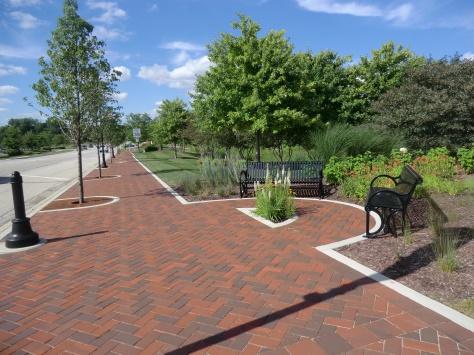
1 Wood Dale Open House Summary 5/18/17 The first public open house for the Wood Dale Comprehensive Plan took place on May 18 th, The program was conducted as a fun community event and there were 216 attendees. Stations were set up to facilitate discussion between residents, property owners, stakeholders, and City officials with each other and the consultant team. A great deal of useful input was provided. It will be incorporated into the mix of data analysis, technical observation, and market assessments done as part of the plan. These factors will all be considered in analyzing alternatives and developing recommendations for the Comprehensive Plan. The following sections summarize the results from each station of the open house. The information is presented in essentially raw data in a summary format. Where examples of comments are used, they are included as representative of general comments provided. IL 390 Station This station involved two large aerial maps and to-scale blocks of representative development options. Attendees were asked for their input on desired future development near the new IL 390 corridor, just south near Wood Dale Road (and the City in general). The following were key topics raised: Residents want more restaurants and shopping throughout the City. The industrial area east of Wood Dale Road is a good place for business: low rent, DuPage County taxes, access to IL 390 and Metra, easy parking, and restaurants/shops on Irving Park Road. There was a desire for community gardens. The Wood Dale Historical Society/Yesterday s Farm is called The Farm by residents and they want it to be used more. Many residents did not like the idea of any high density residential. The 26 acre vacant site prompted many ideas. Most residents want a place to meet and hangout with some residential. Ideas discussed were: a movie theater, park, convention center as there are hotels nearby, big box stores, music in the park/a small Ravinia West (could cost money, shuttle people from train), a walkable area with commercial and curb appeal, senior housing, single-family homes, townhomes. There is potential to connect the Salt Creek Trail through the industrial park to Wood Dale Junior High School.
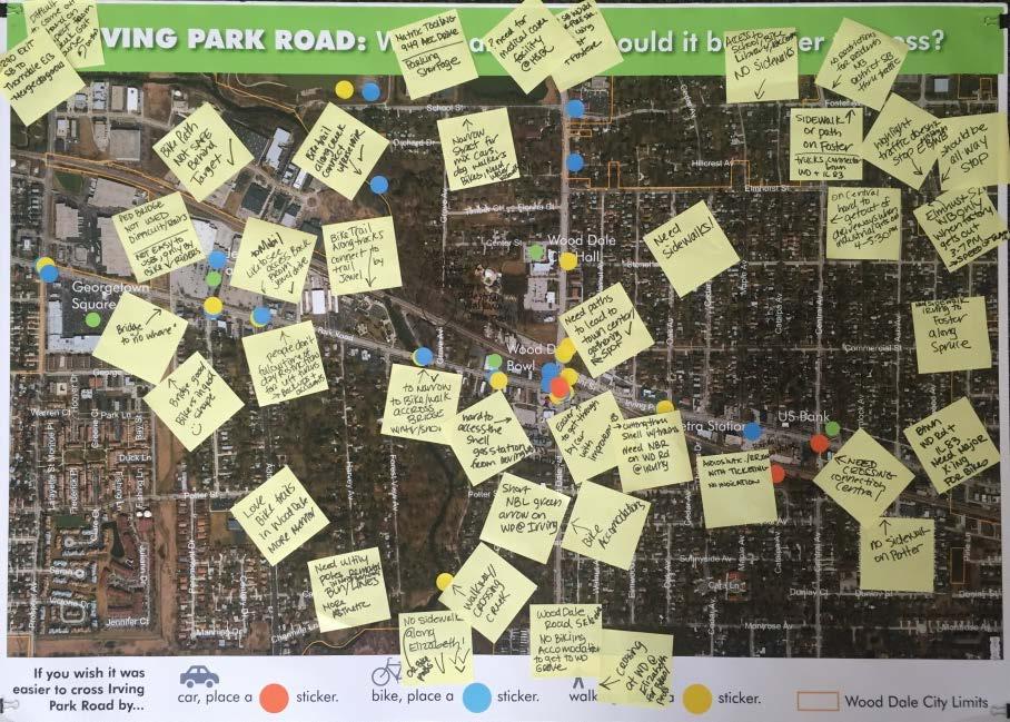
2 Many residents stressed to keep big box retail along the IL 390 corridor as they would attract people into the City to spend money The eastern side of the industrial park causes traffic issues for the residential area to the south. Drivers don t stop, go too fast, or disregard traffic signs at Foster and Central, and Foster and Edgewood. Residents stressed need for a town center. Parks were important to residents. They wanted outdated ones improved, to keep existing fields (like near the Junior High), and to add more soccer fields. Residents noted the desire to find larger, newer homes in Wood Dale as they love the community and want to stay as they need more space. The need for improved property maintenance in residential areas was noted. Some residents discussed the difficulty in modifying their home due to City regulations. They thought If it was easier or there was more of an option to update homes, more residents would do so as opposed to trying to move. Transportation Station This station had three boards for attendees to offer input. One focused on improvements to Irving Park Road (specifically crossings), one asked how people travel to various destinations, and the last involved use of the Metra station. The following are results from those boards and general discussions had between attendees and the consultant: Regarding personal car, in general, most found it very easy to get everywhere they need to go via auto. Several noted how much the improvements at Wood Dale Road and Irving Park Road have made their travels much easier, with the highest amount of compliments going to the northbound left-turn arrow on Wood Dale Road, which permits this movement when a train blocks the crossings. With the arrival of the afternoon commuter trains from Chicago, Wood Dale Road becomes very congested and would benefit from: o Potential for easterly connect to Potter Street and/or Irving Park Road. o Police assistance with traffic exiting the Station. o Longer / adaptive signal to assist with the peak in traffic. With the release of the industrial on Central (typically in the 3-7PM timeframe), residential streets (Elmhurst, Central, Edgewood, Foster) become congested. This raised several questions: o Can traffic be restricted from heading south on Central - forced onto Foster? o Should Edgewood and Elmhurst operate as an All-Way Stop Control intersection? o Can the Edgewood and Elmhurst intersection have supplemental placards, indicating traffic from East/West does not stop? o Is there potential for other traffic calming measures for this area to limit impact of industrial / truck traffic?
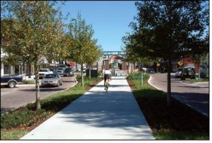
3 There were several comments related to the concern with emergency vehicle response to the west side of the City, in particular when a train blocks the Irving Park / Wood Dale Road intersection. There is also concern with increase in development / changes that the service may be further impacted. Is there an opportunity to provide another connection to Irving Park Road? For the industrial business owners, as well as some residents and other businesses - a shuttle service to the industrial / business parks and/or availability of public transportation to key local destinations (shopping, work, etc.) was desirable. An example was cited how there is Pace available at the Bensenville train station. Metra is an asset to the City, with opportunities being explored to enhance access by walking / biking from areas north and west within the City. More parking and shuttle (as noted above) were also desirable. There was a strong desire by most attendees to enhance the non-auto experience within the City. The network of trails, parks and recreation center were all conveyed as significant assets of the City. There is a need for accommodations along the major roadways (Irving Park Road, Wood Dale Road, Foster Avenue, Addison Road), as well as some other key connectors to parks / schools / recreation - such as along Elizabeth Drive and Spruce ( work with Bensenville), as well as to the neighborhood south of the Reservoir. There was strong concurrence that crossing of Irving Park Road is a challenge - with a need, again for enhancements at the existing major crossings (including the newly redesigned Irving Park Rd / Wood Dale Rd), as well as the need for new crossings - with suggestions as a new major crossing somewhere between Wood Dale Road and IL 83. Filling in the sidewalk gaps and/or providing wider, off-street facilities should be considered. There were also a few concerns noted with biking behind the Target / industrial area, along with the difficulty of crossing the pedestrian bridge over Irving Park Rd in the northbound direction. Some other thoughts: o Need for a central gathering place to bring people together - with improvements provided to make it accessible via foot / bike. Some cited the Amphitheater in Bensenville as a good example. o Wood Dale should be marketed as a commuter / Metra friendly City. What Elmhurst recently did - was citied as a good example. o Streetscape enhancements should be considered along Irving Park Road, as well as some of the neighborhoods (bury utilities) - to make it more aesthetically pleasing. o And lastly - what can be done about the Airplane & Train Horn Noise?
4
 as well as improved sidewalks An indoor pool was noted as something the City needs.")
5 Dear Mayor and Wood Dale Vision Station These worksheets allowed attendees to fill in blanks and/or write open responses about Wood Dale. A handful of themes were repeated in the attendee responses: Wood Dale needs more trails (walking and biking) as well as improved sidewalks An indoor pool was noted as something the City needs. Many responses include the desire for additional open space. This especially included areas for picnics with pavilions, as well as high interest for outdoor concert space and events. Both plane and train noise were noted as issues. The community wants more shopping and restaurants. There was a high desire for additional activities and places for children and teenagers. Respondents asked for increased communication between residents and the City. Irving Park Road s businesses and appearance were issues to the community. Many people wanted parks to have improved maintenance and supervision. There was also a desire for preserving the existing fields in Wood Dale and adding more.
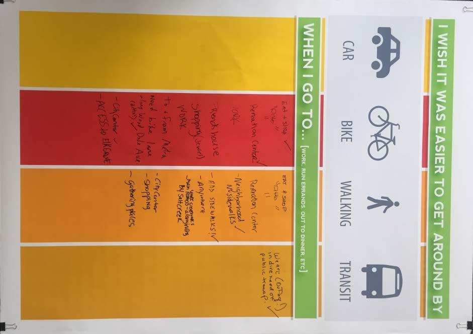
6 Irving Park/Wood Dale Bucks Station This station aimed to find out how attendees would spend money on Irving Park Road. Given 5 votes, 4 options were available to vote on. Those options and their results are below. This highest voted option was to attract additional retailers and restaurants to the corridor. The voting about Irving Park using Wood Dale Bucks results: Improve Transit and Accessibility: 80 votes Improve Appearance of Public Areas: 146 votes Fix up Existing businesses and restaurants: 158 votes Attract Additional Retailers and Restaurants: 195 votes Survey Station A paper survey was provided for attendees to complete. The form asked that attendees provide insights about the City events and amenities they use and how they feel about the services they received. Most Open House attendees lived in Wood Dale and received their public services from Wood Dale governmental districts; most lived in the Fenton High School district. Most responded that they would not be willing to pay an additional fee to use a different park or library district s facilities. In rating the quality of public services (1 being low and 5 being high), library service received mostly 4-5 ratings, police mostly a 5 rating, fire mostly a 5 rating, parks mostly 3-4 ratings, and schools mostly 3-5 ratings. The recreational amenities used most often Wood Dale were walking/running trails, parks, and recreation centers. The highest attended community events by Open House attendees were Prairie Fest, the Memorial Day parade, and the Tree Lighting ceremony. A poster board (below) was used to survey attendees about where they shop in relation to where they live. The results of this exercise show that residents generally shop throughout the City, no matter where they live. However, there is an understanding from previous discussions that residents on the eastern portion of the City may use Route 83 to shop in other communities due to convenient access.


 images for each")
7 Visual Preference Survey Station A visual preference survey was conducted to get impressions from attendees about the forms of development and community enhancements they consider most appealing. Photos were organized into various categories. and, attendees asked to rank images.. The two highest ranked (by weighted average) images for each category are displayed below: Retail and Restaurants
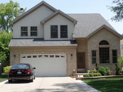
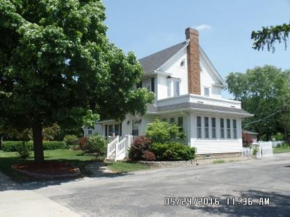
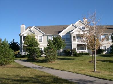
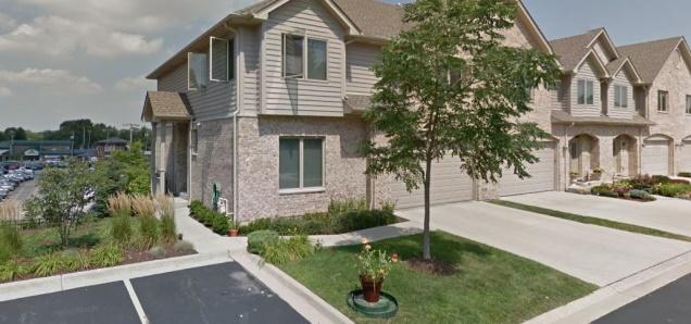
8 Industrial and Office Single Family Residential Multi Family Residential Streetscapes

9 Signage
Macleod Trail Corridor Study. Welcome. Macleod Trail Corridor Study Open House. Presentation of Proposed Design Concepts
 Macleod Trail Corridor Study Welcome Macleod Trail Corridor Study Open House Presentation of Proposed Design Concepts Study Purpose Develop a corridor plan for Macleod Trail that aligns with The City s:
Section II. Planning & Public Process Planning for the Baker/Carver Regional Trail began in 2010 as a City of Minnetrista initiative.
 Section II Planning & Public Process Planning for the began in 2010 as a City of initiative. city staff began discussions with the Park District on the possibility of a north/south regional trail connection
CITIZEN ENGAGEMENT. Who was included in the public input process?
 A CITIZEN CREATED VISION - CITIZEN INPUT This Comprehensive Plan was crafted to respond to what residents of Buda and nearby areas want to see happen. It is a vision that responds to their hopes and concerns
Great Wolf Lodge Fact Sheet & Frequently Asked Questions Potential Location in Gilroy, California 8/30/17
 WHAT? Great Wolf Resorts has identified Gilroy, California as a potential location for a new Great Wolf Lodge family resort and has entered into a 60-day period of exclusivity with the City and community
Lafourche Parish Government REQUEST FOR QUALIFICATIONS. Landscape Architectural Services
 Lafourche Parish Government REQUEST FOR QUALIFICATIONS Landscape Architectural Services Bayou Lafourche Parish Multi-Use Path Feasibility Study Phase 1 And Bayou Lafourche Parish Multi-Use Path Feasibility
Colorado Springs & Pikes Peak Region Destination Master Plan
 Colorado Springs & Pikes Peak Region Destination Master Plan Overview June 19, 2018 DESTINATION MASTER PLAN What is Destination Master Planning? Focus on infrastructure, facilities, services, attractions
EXHIBIT 1. BOARD AUTHORIZATION FOR PUBLIC HEARING AND SUBSEQUENT ISSUANCE OF A JOINT DEVELOPMENT SOLICITATION
 EXHIBIT 1. BOARD AUTHORIZATION FOR PUBLIC HEARING AND SUBSEQUENT ISSUANCE OF A JOINT DEVELOPMENT SOLICITATION Washington Metropolitan Area Transit Authority Board Action/Information Summary @Action O Information
Commuter Park and Ride Steering Committee Meeting Notes August 7, :00 a.m. to 11:00 a.m. Attendees Name Organization Phone
 Commuter Park and Ride Steering Committee Meeting Notes August 7, 2013 10:00 a.m. to 11:00 a.m. Attendees Name Organization Email Phone Eileen Horn Lawrence/Douglas County ehorn@lawrenceks.org 785-330-3121
COMMUNICATIONS DEPARTMENT (Lisa Belsanti, Director) (Joshua Schare, Public Information Officer)
 (Joshua Schare, Public Information Officer)") CITY COUNCIL UNFINISHED BUSINESS AUGUST 21, 2017 SUBJECT: INITIATED BY: SUNSET STRIP ENTERTAINMENT SHUTTLE - PILOT PROGRAM HUMAN SERVICES & RENT STABILIZATION DEPARTMENT (Elizabeth Savage, Director) 'fj1f'..
CITY COUNCIL UNFINISHED BUSINESS AUGUST 21, 2017 SUBJECT: INITIATED BY: SUNSET STRIP ENTERTAINMENT SHUTTLE - PILOT PROGRAM HUMAN SERVICES & RENT STABILIZATION DEPARTMENT (Elizabeth Savage, Director) 'fj1f'..
CHAPTER 3 PLANNING GOALS
 CHAPTER 3 PLANNING GOALS AND PUBLIC INPUT INTRODUCTION This portion of the Algonac Master Plan is intended to outline a course for action in achieving the community s vision for the future. Throughout
Longmont to Boulder Regional Trail Jay Road Connection DRAFT FINAL REPORT
 Longmont to Boulder Regional Trail Jay Road Connection DRAFT FINAL REPORT December 2018 Project Summary Boulder County, Colorado, in partnership with the City of Boulder, is evaluating options for multi-use
A VISION FOR EL MIRAGE
 el mirage A VISION FOR EL MIRAGE OASIS, ARIZONA A thriving desert jewel destination with a strong arts district, high-wage employment parks system joined together by cohesive, multi-use accessible trails
Mercer Island Town Center Stakeholder Meeting E. June 10, 2015
 Mercer Island Town Center Stakeholder Meeting E June 10, 2015 DATE Tue. June 16 (5:30 7:30 pm) Wed. June 24 (5:30-7:00 pm) Council Chambers Tue. June 30 (5:30 8:30 pm) July 11/12 Thur. July 16 (5:30 7:30
SR 934 Project Development And Environment (PD&E) Study
 Study") SR 934 Project Development And Environment (PD&E) Study Project Advisory Group Meeting March 1, 2018 State Road 934/NE/NW 79th Street from west of I-95 (NW 13th CT) to N. Bayshore Drive PD&E STUDY SR 934/NE/NW
SR 934 Project Development And Environment (PD&E) Study Project Advisory Group Meeting March 1, 2018 State Road 934/NE/NW 79th Street from west of I-95 (NW 13th CT) to N. Bayshore Drive PD&E STUDY SR 934/NE/NW
Georgetown-Lewes Rail/Trail Study. Rail/Trail Study: Cool Spring to Cape Henlopen State Park New Road Extension (House Resolution No.
 Georgetown-Lewes Rail/Trail Study Rail/Trail Study: Cool Spring to Cape Henlopen State Park New Road Extension (House Resolution No. 47) August 22, 2011 Presentation Outline Background Benefits Statewide
FINCH HYDRO CORRIDOR TRAIL PROJECT
 FINCH HYDRO CORRIDOR TRAIL PROJECT Pharmacy Avenue to Birchmount Road January 29 th, 2018 L Amoreaux Community Centre (2000 McNicoll Avenue) 1 Purpose of Drop In Event The purpose of today s drop-in event
DRAFT Appendix A Appendix B. Planning Process & Public Participation
 1 2 3 4 5 Appendix A Appendix B Planning Process & Public Participation This chapter provides an overview of the planning process. Summaries of public input for the comprehensive planning process are provided.
Non-Motorized Transportation
 Non-Motorized Transportation Non-motorized facilities are important components to the transportation system. They provide an environmentally-friendly, low-cost mode of travel. Some of the facilities can
BUSINESS OF THE CITY COUNCIL CITY OF MERCER ISLAND, WA
 BUSINESS OF THE CITY COUNCIL CITY OF MERCER ISLAND, WA December 1, 2008 Public Hearing TOWN CENTER PARKING TIME LIMITS (FIRST READING) Proposed Council Action: Conduct public hearing and first reading
Bloor Street West Rezoning Application for a Temporary Use By-law Final Report
 STAFF REPORT ACTION REQUIRED 3741 3751 Bloor Street West Rezoning Application for a Temporary Use By-law Final Report Date: June 12, 2007 To: From: Wards: Reference Number: Etobicoke York Community Council
Alliant Energy Center Visioning Workshop Input Madison, WI July 20, 2017
 Alliant Energy Center Visioning Workshop Input Madison, WI July 2, 217 A neighborhood meeting was held on July 18 and 19 th, 217 to gather community feedback on the topics of connections, destination district,
University Region Non-Motorized Plan 2015
 Non-Motorized Transportation Non-motorized facilities are important components to the transportation system. They provide an environmentally-friendly, low-cost mode of travel. Some of the facilities can
THE STATE OF GRAYSLAKE
 THE STATE OF GRAYSLAKE Presented by: Mayor Rhett Taylor January 23, 2014 The State of Grayslake Economic Development Transportation Village Center Plans Economic Development Cost Savings Programs: Village
Boston Redevelopment Authority 2/26/ Chestnut Hill Avenue Boston/Brookline, MA
 Boston Redevelopment Authority 2/26/2014 Cassidy Playground Waterworks Design revisions made since the DPIR submission March 2013 Massing - Reduced project 16,030 SF, for a total project area of 218,520
Weathersfield Township Economic Development Public Input Survey Results Summary
 Picture Source: Hammond Construction http://hammondconstruction.com/portfolio/weathersfield-local-schools/ Weathersfield Township Economic Development Public Input Survey Results Summary February, 2018
Des Plaines River Trail Southern Segment Corridor Plan
 Des Plaines River Trail Southern Segment Corridor Plan 1 TABLE OF CONTENTS PURPOSE OF THE PLAN 3 HISTORY OF THE DES PLAINES RIVER TRAIL 4 EXISTING CONDITIONS FOR THE SOUTHERN SEGMENT 6 WHY THE SOUTHERN
Fuller/Fuller Heights Road Improvements
 Fuller/Fuller Heights Road Improvements Total Project Cost - $4.4M Project Description This project will construct a mini-roundabout at the intersection of Fuller Heights Road and Old Triangle Road to
Gold Coast. Rapid Transit. Chapter twelve Social impact. Chapter content
 Gold Coast Rapid Transit Chapter twelve Social impact Chapter content Social impact assessment process...235 Existing community profile...237 Consultation...238 Social impacts and mitigation strategies...239
Former Middle School Site Green Space & Brecksville Road Streetscape. March 27, 2018
 Former Middle School Site Green Space & Brecksville Road Streetscape March 27, 2018 Brecksville Streetscape & Downtown Greenspace Project Schedule City of Indepenence 2017 2018 Meeting Schedule Tasks/Deliverables
This report recommends that Council approve concept plan 021-CP-001-B (see Attachment 1), for detailed design and delivery this financial year.
, for detailed design and delivery this financial year.") FPOL1711-9 HILTON TOWN CENTRE PROJECT SCOPE Meeting Date: 0 Responsible Officer: Manager Infrastructure Engineering Decision Making Authority: Council Agenda Attachments: 1. Concept Plan no 021-CP-001-B
FPOL1711-9 HILTON TOWN CENTRE PROJECT SCOPE Meeting Date: 0 Responsible Officer: Manager Infrastructure Engineering Decision Making Authority: Council Agenda Attachments: 1. Concept Plan no 021-CP-001-B
Stuart Thain. Elizabeth Leader Cameron Simonsen
 I-15 AND SOUTHERN PARKWAY ST GEORGE, UT Developed by: Desert Color is a master-planned community built around a plan of connectivity, community and sustainability. It is a place where you will find the
POWELL COMPREHENSIVE PLAN UPDATE STEERING COMMITTEE MEETING
 POWELL COMPREHENSIVE PLAN UPDATE Creating Tomorrow s Horizon Plan Powell City Comprehensive Plan STEERING COMMITTEE MEETING - 05.26.15 AGENDA 1. Call To Order 2. Approval Of Minutes (March 24, 2015) 3.
Airport Planning Area
 PLANNING AREA POLICIES l AIRPORT Airport Planning Area LOCATION AND CONTEXT The Airport Planning Area ( Airport area ) is a key part of Boise s economy and transportation network; it features a multi-purpose
Update on Trinity Trails. Presented by: Richard Zavala, Director Park and Recreation Department February 7, 2017
 Update on Trinity Trails Presented by: Richard Zavala, Director Park and Recreation Department February 7, 2017 Overview Provide review of trail planning and development along the main stem Trinity River
Tinker Air Force Base, Oklahoma
 Table 5.4 Generalized Zoning within the Tinker AFB Clear Zones and Accident Potential Zones (Off-Installation) Category Acreage Residential 1,486 Commercial 191 Industrial 128 Public/Quasi-public 0 Recreational/Open/Agricultural/Low
Area Surrounding Maplewood Manor
 BAY CITY, MICHIGAN HOUSING COMMISSION Neighborhood Revitalization Plan Area Surrounding Maplewood Manor January 13, 2014 CITY COMMISSION DRAFT PLAN PRESENTATION BAY CITY, MICHIGAN 1 Planners Phil McKenna,
A. CONCLUSIONS OF THE FGEIS
 Chapter 11: Traffic and Parking A. CONCLUSIONS OF THE FGEIS The FGEIS found that the Approved Plan will generate a substantial volume of vehicular and pedestrian activity, including an estimated 1,300
VRE Manassas Park Station Parking Expansion Alternatives Analysis
 VRE Manassas Park Station Parking Expansion Alternatives Analysis Summary Report September 18, 2017 THIS PAGE INTENTIONALLY LEFT BLANK Table of Contents 1.0 Introduction... 1 2.0 Summary of Existing Conditions...3
Frequently Asked Questions on the Route 29 Solutions Improvements Projects
 Frequently Asked Questions on the Route 29 Solutions Improvements Projects Background What are the Route 29 Solutions improvement projects? These projects include the Route 29/250 Interchange ( Best Buy
Project Deliverable 4.1.3d Individual City Report - City of La Verne
 Pomona Valley ITS Project Project Deliverable 4.1.3d Individual City Report - City of La Verne Prepared by: April 19, 2002 099017000.1 Copyright 2002, Kimley-Horn and Associates, Inc TABLE OF CONTENTS
SECOR AND RIDGE ROADS MEETING APRIL 29, 2008 Break Out Group Visioning
 , Town Councilman and CPSC Chair SECOR AND RIDGE ROADS MEETING APRIL 29, 2008 Break Out Group Visioning TRANSPORTATION: GROUP LEADER Ronald Hubert Stone Oak residents it is impossible to get out during
Everett Riverwalk Life style explore
 Life style explore Project Overview The 217-acre Everett Riverfront redevelopment is visible from I-5 with traffic counts charted at 170,000+ vehicles per day with direct freeway access from 4-way interchange.
ARLINGTON COUNTY, VIRGINIA
 ARLINGTON COUNTY, VIRGINIA County Board Agenda Item Meeting of March 12, 2016 DATE: March 1, 2016 SUBJECT: SP-331-U-12-1 USE PERMIT ASSOCIATED WITH A SITE PLAN review for Live Entertainment, Dancing and
Glasgow Street Traffic Review
 Glasgow Street Traffic Review Recommendation That the Standing Policy Committee on Transportation recommend to City Council: 1. That the Administration proceed with removing the pinch points installed
VILLAGE OF ROMEOVILLE COMPREHENSIVE PLAN
 VILLAGE OF ROMEOVILLE COMPREHENSIVE PLAN STEERING COMMITTEE MEETING #4 February 2, 2017 SUBAREA DEVELOPMENT CONCEPT PLANS OVERVIEW 1. Introduction 2. Project Timeline 3. Subarea Development Concept Plans
8201 W Higgins 8201 Higgins. Unique Opportunity Available
 8201 Higgins Unique Opportunity Available Contents 03 Opportunity Highlights 04 Location 05 Potential Synergies with Adjacent Hotel 07 Site Aerial 08 Accessibility 09 Area information, Chicago, IL 02 Opportunity
5.1 Traffic and Transportation
 5.1 When it opens in 2009, the Bellevue Nickel Improvement Project will increase the number of vehicles able to travel through the study area, improve travel speeds, and improve safety by reducing the
New 55-Dogpatch Outreach Findings & Route Development
 Executive Summary Based on outreach conducted through Spring of 2018, the SFMTA identified a set of three alternative routes and service plans for a new 55-Dogpatch route. These alternatives respond to
Route 29 Solutions Projects
 Your guide to the Route 29 Solutions Projects For full details & continued engagement please visit www.route29solutions.org The Route 29 Solutions Package is a $230 million investment into the improvement
SOUTH INTERCHANGE AREA
 Santaquin City General Plan 1 Location and Characteristics The South Interchange Area of Santaquin is located west of Interstate 15 and south of 500 South (Figure 1). It includes properties already annexed
Northwest Corridor Transit Study
 Northwest Corridor Transit Study Presentation to Windsor Business Breakfast May 7, 2009 Sandy Fry, Capitol Region Council of Governments 3 Elements to Study 1. Build ridership in the Northwest corridor
PURPOSE AND NEED (CONCURRENCE POINT 1) NEW CANADA ROAD PROJECT FROM STATE ROUTE 1 (U.S. HIGHWAY 70) TO U.S. INTERSTATE 40
 NEW CANADA ROAD PROJECT FROM STATE ROUTE 1 (U.S. HIGHWAY 70) TO U.S. INTERSTATE 40") PURPOSE AND NEED (CONCURRENCE POINT 1) NEW CANADA ROAD PROJECT FROM STATE ROUTE 1 (U.S. HIGHWAY 70) TO U.S. INTERSTATE 40 Project Description The primary purpose of this project is to improve the major
PURPOSE AND NEED (CONCURRENCE POINT 1) NEW CANADA ROAD PROJECT FROM STATE ROUTE 1 (U.S. HIGHWAY 70) TO U.S. INTERSTATE 40 Project Description The primary purpose of this project is to improve the major
Arlington County Board Meeting Project Briefing. October 20, 2015
 Arlington County Board Meeting Project Briefing October 20, 2015 Project Map 2 Project Context Only Interstate in the Country limited to HOV only traffic during rush hours Stoplight at the end of I-66
Transportation TRANSPORTATION PROJECTS
 Transportation TRANSPORTATION PROJECTS Balls Ford Road Interchange Total Project Cost $142.9M This project includes the construction of a new diverging diamond interchange at Route 234 Bypass (Prince William
To apprise Council of the process and timeline for the preparation of the Final Concept Plan and report; and
 Corporate NO: R243 Report COUNCIL DATE: November 20, 2006 REGULAR COUNCIL TO: Mayor & Council DATE: November 15, 2006 FROM: Acting General Manager, Planning and Development FILE: 0850-20 (CF) SUBJECT:
Public Transit Services on NH 120 Claremont - Lebanon
 Public Transit Services on NH 120 Claremont - Lebanon Overview of Preferred Alternative April 12, 2011 Presentation Overview Study Goals Quick Review Methodology and Approach Key Findings Results of Public
Silver Lake Park An Environmental Jewel for the Citizens of Prince William County
 Silver Lake Park An Environmental Jewel for the Citizens of Prince William County The Prince William Park Authority Mission Statement states: The Prince William County Park Authority will create quality
Introduction. Project Overview
 Washington Blvd./Andora Widening Project Community Open House & Public Scoping Meeting Summary Wednesday, September 21, 2016 6:00 7:30 p.m. Vencil Brown Elementary School, Roseville Introduction On Wednesday,
RESORT AREA STRATEGIC ACTION PLAN (RASAP) STEERING COMMITTEE MEETING - APRIL 3, 2019
 STEERING COMMITTEE MEETING - APRIL 3, 2019") RESORT AREA STRATEGIC ACTION PLAN (RASAP) STEERING COMMITTEE MEETING - APRIL 3, 2019 Welcome & Introductions - Deb Zywna AGENDA FY 20 Resort CIP Proposed Projects - Kathy Warren ORDFBC Design Guidelines
RESORT AREA STRATEGIC ACTION PLAN (RASAP) STEERING COMMITTEE MEETING - APRIL 3, 2019 Welcome & Introductions - Deb Zywna AGENDA FY 20 Resort CIP Proposed Projects - Kathy Warren ORDFBC Design Guidelines
4. Safety Concerns Potential Short and Medium-Term Improvements
 NH Route 104 Access Management Study Page 19 4. Safety Concerns Potential Short and Medium-Term Improvements Potential safety improvement strategies are listed by priority based on field observations by
4.0 Context for the Crossing Project
 4.0 Context for the Crossing Project This section provides background information about key features of the North Douglas Crossing project area, and opportunities and constraints. This information is important
user s guide to Transportation Improvements in Astoria Planning Efforts outside Astoria for more information, contact:
 The Miles Crossing/ Jeffers Garden transportation plan (underway), will identify needed improvements to the Warrenton Astoria Highway and local street improvements to serve expected growth in the Miles
Citrus Heights Creek Corridor Trail Project Trail Advisory Group Field Trip #2 September 11, :00 11:00 am Trellis Hall, Citrus Heights
 September 11, 2013 9:00 11:00 am Trellis Hall, Citrus Heights Project Overview The City of Citrus Heights is studying the feasibility of establishing a multi use trail system within the City s 26 miles
TABLE OF CONTENTS. Coral Springs Charter High School and Middle School Job No Page 2
 Job No. 15-019 Page 2 TABLE OF CONTENTS 1.0 INTRODUCTION... 4 2.0 EXISTING CONDITIONS... 5 3.0 TRAFFIC GENERATION... 7 4.0 TRIP DISTRIBUTION... 8 5.0 FUTURE CONDITIONS... 8 6.0 SITE ACCESS...13 7.0 CONCLUSION...13
PROJECT.
 A PROJECT 1 2 0 0 R o u t e 2 0 6 M o n t g o m e r y T o w n s h i p, N J 0 8 5 4 0 www.montgomerypromenade.net WELCOME TO MONTGOMERY Montgomery Promenade is a 300,000 square foot regional shopping/entertainment
WEST JORDAN PARKS, RECREATION AND TRAILS MASTER PLAN Advisory Committee Meeting #2
 WEST JORDAN PARKS, RECREATION AND TRAILS MASTER PLAN Advisory Committee Meeting #2 MONDAY, NOVEMBER 5, 2018, 6:00 P.M.; PARKS DEPT. CONFERENCE ROOM ATTENDEES: Lisa Dean Larry Gardner Duane Harding David
Regulations to deter cut-through traffic - Heath Street V\fest, between Spadina Road and Avenue Road. Toronto and East York Community Council
 TORONTO STAFF REPORT ACTION REQUIRED Regulations to deter cut-through traffic - Heath Street V\fest, between Spadina Road and Avenue Road Dnte: February 16,2009 To: From: Toronto and East York Community
1.2 Corridor History and Current Characteristics
 SECTION 1 Description and Background of Study Area 1.1 Introduction This preliminary engineering report was prepared for the Alaska Department of Transportation and Public Facilities (ADOT&PF). It is part
Participant Responses April 19, 2017 Open House Meeting
 Hugo 2040 Comprehensive Plan Update Participant Responses April 19, 2017 Open House Meeting Thank you for participating in Hugo s Comprehensive Plan Update. The Comprehensive Plan is the document that
CHAPTER FIVE PROSPECTS FOR FUTURE ECONOMIC DEVELOPMENT
 CHAPTER FIVE PROSPECTS FOR FUTURE ECONOMIC DEVELOPMENT 5.1 GENERAL The recommended type and location of future land uses in Alpine should, in part, consider potential opportunities for future economic
Lake Erie Commerce Center Traffic Analysis
 LOCATION: East of NYS Route 5 at Bayview Road Town of Hamburg Erie County, New York PREPARED BY: Wendel Companies 140 John James Audubon Parkway Suite 200 Amherst, New York 14228 January 2012 i ii Table
UNIVERSITY CITY TOMORROW S URBAN CENTER
 UNIVERSIT Y CIT Y TO M O R R O W S U R B A N C E N T E R ABOUT University City: Tomorrow s Urban Center University City is poised to begin a new chapter as the opening of Charlotte s LYNX Blue Line Extension
MESA COUNTY DEPARTMENT OF PUBLIC WORKS Administration - Building - Engineering Road and Bridge Traffic - Planning - Solid Waste Management
 MESA COUNTY DEPARTMENT OF PUBLIC WORKS Administration - Building - Engineering Road and Bridge Traffic - Planning - Solid Waste Management 200 S. Spruce St. P.O. Box 20,000 Grand Junction, Colorado 81502-5022
NOTE: YOU MAY COMPLETE THIS SURVEY ONLINE (USING THIS DOCUMENT TO VIEW MAPS AND GRAPHICS) AT:
 AT:") for completing the Town of Beech Mountain Comprehensive Planning Survey. The information you provide in reply to the following questions will be used to help the Town develop a plan that will guide our
for completing the Town of Beech Mountain Comprehensive Planning Survey. The information you provide in reply to the following questions will be used to help the Town develop a plan that will guide our
The Baker/Carver Regional Trail is intended to
 Section V Design Guidance The Baker/Carver Regional Trail is intended to safely accommodate 183,000 annual visits, an array of non-motorized uses, a variety of skill levels, and persons with special needs.
The Master Plan, Walkability, and Trails in the City of Solon. April 23, 2018
 The Master Plan, Walkability, and Trails in the City of Solon April 23, 2018 Tonight s topics 1. Existing trail options in the City of Solon 2. Potential trail options 3. How trails and walkability converge
AGENDA ITEM 5 D WAKULLA ENVIRONMENTAL INSTITUTE (WEI) TRAIL FEASIBILITY STUDY
 TRAIL FEASIBILITY STUDY") March 19, 2018 AGENDA ITEM 5 D WAKULLA ENVIRONMENTAL INSTITUTE (WEI) TRAIL FEASIBILITY STUDY TYPE OF ITEM: Action STATEMENT OF ISSUE The Wakulla Environmental Institute (WEI) Trail is one of several trails
March 19, 2018 AGENDA ITEM 5 D WAKULLA ENVIRONMENTAL INSTITUTE (WEI) TRAIL FEASIBILITY STUDY TYPE OF ITEM: Action STATEMENT OF ISSUE The Wakulla Environmental Institute (WEI) Trail is one of several trails
Rating: 5.0 (scale of 1-10)
") 95 Community Trail System Groundcover: 2-metre paved path, 1- metre grass buffer on either side. Location: Fort St. John Ownership: City of Fort St. John Rating: 5.0 (scale of 1-10) Strategic value: Linear
95 Community Trail System Groundcover: 2-metre paved path, 1- metre grass buffer on either side. Location: Fort St. John Ownership: City of Fort St. John Rating: 5.0 (scale of 1-10) Strategic value: Linear
Welcome to the Cross County Trail Public Input Session!
 Welcome to the Cross County Trail Public Input Session! Please sign in on the table below! What are we doing here? Camden County has proposed a bicycle and pedestrian trail spanning across the entire county.
AGENDA ITEM I-6 Public Works
 AGENDA ITEM I-6 Public Works STAFF REPORT City Council Meeting Date: 8/6/2018 Staff Report Number: 18-150-CC Informational Item: Update on the Willow Road and highway 101 interchange construction, upcoming
SAN RAFAEL CITY COUNCIL AGENDA REPORT
 Agenda Item No: 5.e Meeting Date: October 3, 2016 Department: Public Works SAN RAFAEL CITY COUNCIL AGENDA REPORT Prepared by: Bill Guerin, Director of Public Works TOPIC: QUIET ZONE DESIGNATION City Manager
Proposed Bicycle Lanes on Yonge Street from Queens Quay to Front Street
 STAFF REPORT ACTION REQUIRED Proposed Bicycle Lanes on Yonge Street from Queens Quay to Front Street Date: March 12, 2007 To: From: Toronto and East York Community Council Director, Transportation Infrastructure
Hudson Highlands Fjord Trail Draft Master Plan. April 29, 2015
 Hudson Highlands Fjord Trail Draft Master Plan April 29, 2015 Agenda Route Overview Proposed Segment Results of Community Survey on that Segment Next Steps Municipal Endorsement Environmental Review Implementation
ZoPath Trail. Extreme Park. Group III. Brendan Pillar, Conor Coakley James Amendola, & Mark McDermott. May 4, 2006
 ZoPath Trail & Extreme Park Group III Brendan Pillar, Conor Coakley James Amendola, & Mark McDermott May 4, 2006 HOW TO GET FROM THE TOWPATH S NORTHERN TRAILHEAD TO HERE? Bridging Two 1 st -Class Regional
McLean Citizens Association Transportation Committee Project Briefing
 McLean Citizens Association Transportation Committee Project Briefing November 10, 2015 Project Map 2 Project Context Only Interstate in the Country limited to HOV only traffic during rush hours Stoplight
New free City connector bus service
 The Adelaide City Council invites engagement from the community about New free City connector bus service 99C City Loop and Adelaide Connector free bus services to merge: Project Summary Adelaide City
PIONEER PARK. City of Des Peres Parks Master Plan. SWT Design 46 INTRODUCTION
 PIONEER PARK INTRODUCTION Pioneer Park is a 7 acre neighborhood park located east of Interstate 270 and south of Manchester Road along Tallie Road. The park is situated in a residential neighborhood with
Regional Wayfinding Sign Strategy Thurston County Trails 2017
 Regional Wayfinding Sign Strategy Thurston County Trails 2017 Partners: Members and partnering organizations of the Thurston Thrives Community Design Action Team City of Lacey, City of Olympia, City of
Ozaukee County Transit Development Plan
 Ozaukee County Transit Development Plan Record of Public Comments and Recommended Transit Service Plan June 5, 2018 Kevin Muhs Deputy Director #242846 Status of the Transit Development Plan Existing Conditions
Public Workshop #1 Results Report. October 31, 2017
 Public Workshop # Results Report October 3, 07 Table of Contents Section : Introduction... 3 Section : Comment Card Responses... 4 Section 3: Additional Comments... 3 Section 4: Full Comment Summary...
CONTENTS. 1 Introduction Always Moving Forward while Building on the Past A Dynamic Destination... 5
 2010 STRUCTURE PLAN - 2 - CONTENTS 1 Introduction... 5 1.1 Always Moving Forward while Building on the Past... 5 1.2 A Dynamic Destination... 5 2 Map A... 6 Exhibition Place and its Neighbours... 7 3 Demonstration
Blueways: Rivers, lakes, or streams with public access for recreation that includes fishing, nature observation, and opportunities for boating.
 Parks, Open Space and Trails PRINCE WILLIAM COUNTY 2008 COMPREHENSIVE PLAN TRAILS PLAN CONTENTS The components of the trails plan are: Intent Definitions Goals, Policies, and Action Strategies Trails Map
POWELL COMPREHENSIVE PLAN UPDATE STEERING COMMITTEE MEETING
 POWELL COMPREHENSIVE PLAN UPDATE Creating Tomorrow s Horizon Plan Powell City Comprehensive Plan STEERING COMMITTEE MEETING - 02.24.15 AGENDA 1. Call To Order 2. Approval Of Minutes (January 27, 2015)
Ground Lease W LINCOLN AVE DRIVE-THRU OPPORTUNITY ANAHEIM, CA Newport Center Drive, Newport Beach, CA 92660
 Ground Lease 2790 ANAHEIM, CA 92801 DRIVE-THRU OPPORTUNITY 610 Newport Center Drive, Newport Beach, CA 92660 Drive-Thru Opportunity Anaheim, CA 92801 DESCRIPTION: 2790 W Lincoln Ave is an incredible drive
S i t e A n a ly s i s
 S i t e A n a ly s i s 11 SECTION B SITE ANALYSIS Existing Conditions TRANSPORTATION CONTEXT: The Ohlone Greenway site, paralleling San Pablo Avenue to the west, is centrally located within the City of
T H E T O W N C E N T E R
 T O W N C E N T E R T H E T O W N C E N T E R S imply redefining retail and entertainment in Southern Indiana: Jeffersonville Town Center is the first open-air retail center in the area combining upscale
4. Proposed Transit Improvements
 4. Proposed Transit Improvements The following proposed transit improvements have been assembled based on input received from the community meetings and from review and coordination with the TAC as well
A number of goals were identified during the initial work on this Big Lake Transportation Plan.
 C. Transportation General Background Information Big Lake s transportation system includes all the roads, paths and facilities that allow the movement of private vehicles, trains and planes, as well as
Second Avenue: Union Street to Lenora Street, Condominium Owners c/o Michael McQuaid 1521 Second Avenue Seattle, WA 98101
 Second Avenue: Union Street to Lenora Street, Condominium Owners c/o Michael McQuaid 1521 Second Avenue Seattle, WA 98101 Subject: New Development - Cumulative Downtown Alley Traffic Congestion and Safety
Tropicana Public Workshop August 22, Image: City of St. Petersburg
 Tropicana Public Workshop August 22, 2016 Image: City of St. Petersburg City of St. Petersburg Planning & Economic Development Department Leading the Process HKS Urban Design Randy Morton Julie Hiromoto