a. The historic avalanche areas, or areas in which there exists clear evidence of previous avalanches, are mapped.
|
|
|
- Logan Todd
- 5 years ago
- Views:
Transcription


1 1 OBJECTIVES AND LIMITATIONS OF STUDY ;J'-o~ 1 j 1.1 BACKGROUND AND STUDY OBJECTIVES The communities of Aspendell, Habegger's, and Sage Flat are located in the eastern Sierra Nevada west of the towns of Bishop and Big Pine, in Inyo County, California (Figure 1-1).These developed areas are located adjacent to steep slopes which occasionally receive heavy snows and avalanches. Major snow avalanches have occurred within and adjacent to all three of these areas, most recently in 1969 and Buildings intended for human occupancy have been destroyed in 1969 and Both year-round and seasonal populations are increasing~ll three areas. In some cases development is expanding directly into areas previously affected by avalanches. A natural consequence of increased development in avalanche areas is an ~ncrease in "hazard," which, of course depends on both the natura1 avalanche conditions and the human exposure to this condition. Avalanche hazard can be reduced through appropriate land-use and construction practices. These practices can be referred to collectively as "mitigation," rational procedures through which avalanche hazard can be reduced. In order to identify the appropriate mitigation procedures, Inyo County has undertaken this study which has accomplished the following objectives. '.. '-') a. The historic avalanche areas, or areas in which there exists clear evidence of previous avalanches, are mapped. b. The potential avalanche areas are also mapped. These are areas in which avalanches may occur in approximatelya loo-year period even through there may be no historic record of avalanches in these areas. c. Avalanche mitigation concepts through which the avalanche hazard can be reduced are discussed. The report has been organized so each of the objectives "a" through "c" are applied to each of the three areas separately. Chapter 2 discusses the hazard and mitigation in Aspendell, Chapter 3 concentrates on Habegger's, and Chapter 4 on Sage Flat. 1.2 STUDY LIMITATIONS The study has important limitations which must be understood by those utilizing the material presented here. a. The study maps areas subject to reasonably foreseeable avalanches. These are areas which, based on the experience of the author in the Sierra Nevada and other mountain areas of the world, may produce 3


2 ,-. avalanches once in 100 years, on the average. Many of the avalanche runout areas within the mapped limits are reached much more often than that, as the historic record shows. This is true because as one approaches the base of a mountain, avalanche frequency increases. On the other hand, there may be some areas that have not been indicated as avalanche-prone in this study where extremely rare events may occur. In general, any slope in excess of approximately 25 may produce avalanches when very unstable snow conditions exist. These areas are omitted because avalanches will be so rare as to not warrant consideration in the land-use and planning process. b. The maps should not be used for recreational or back country purposes. An area designated as "hazardous" for construction purposes where objects such as dwellings are exposed continuously may not constitute a significant hazard to back country use which, in contrast, is transient and exposed rarely. c. The potential avalanche runout limits are based upon a large body of empirical knowledge gained about major avalanches in the Sierra Nevada and elsewhere. Although the potential runout limits are "theoretical" they are based on the best available methods and procedures in use throughout the world. As more research is done and observations are obtained, details about defense-structure design may change. The runout-distances probably will not change significantly, however, because topographic barriers constrain avalanche flow in the study area. d. This is not an engineering-design study. Final design of all protection structures require input of registered engineers or other professionals as required by California law. 1.3 THE AVALANCHE PHENOMENA. Inyo County extends into steep mountainous terrain subject to heavy rain and snow, high winds, and rapidly changing weather conditions. This combination of weather and terrain favors frequent and sometimes severe snow avalanching. Typically, avalanches will be small, occur on steep slopes or in unpopulated back country areas, and will go unnoticed by residents. However, during unusual and severe conditions, massive volumes of snow will simultaneously release from steep slopes (typically 'in the 30O-to-4So range), will develop into major dry- or wet-snow avalanches, and will extend unexpectedly long distances across!ow-gradient or level terrain. The major events of interes~ in mountain land planning usually have return periods of 50 or 100 years. Therefore many decades may pass between major avalanches. Avalanche runout zones (areas in which avalanches decelerate and stop), sometimes ~ience residential development during the 4
, where extensive building in the avalanche runout zone of the \"Hambone Canyon\" avalanche occurred between the large avalanches of 1969 and")


3 long periods between major events. This is the case in Inyo County (especially at Aspendell), where extensive building in the avalanche runout zone of the "Hambone Canyon" avalanche occurred between the large avalanches of 1969 and See Chapter 2 for details. New buildings within Inyo County avalanche run out zones have not been sited or designed to avoid or minimize the avalanche hazard. Therefore occupants of these buildings may be exposed to great personal risk during the usual avalanche conditions, which may occur during any winter or spring. The major avalanches of concern here result from failure of large volumes of wet or dry snow, generally from 30O-to-45 slopes located 1,000-to-3,000 feet above the developed sites. The ~ flowing avalanches may reach maximum velocities of 100-to-130 mph during extreme conditions and can extend, at locations similar to Aspendell, for 1,500 feet or more over low-gradient terrain. These avalanches are very destructive and damage :or destroy buildings through crushing, and relocation. High velocity dry-flowing avalanches are usually accompanied by a powder-avalanche component of lesser destructive potential but even longer runout-distance potential. Powder avalanches may completely envelope large structures subjecting them to forces similar to those produced by a strong wind of increased density. Powder avalanches typically blowout windows or doors and may lift roofs off buildings. Large powder avalanches (such as those in portions of the Habegger's and bage Flat areas) may flatten buildings with destructive forces in excess of those associated with well-developed hurricanes. Wet-snow avalanches ("wet slides") will also reach developed areas in Inyo County. These slides will rarely exceed 50 mph even on steep slopes, but can advance for long distances across moderate terrain because of the reduced frictional resistance at the avalanche boundaries. Large wet slides may also be very destructive as thick ridges of snow subject structures to crushing overburden pressures. Wet slides will often spread into separate: flow fingers in the runout zone. The direction of each finger of the flow is difficult to predict in advance. The destructive effects of snow avalanches are well known throughout the mountainous regions of the world. The Eastern Sierra, with its impressive topography and heavy snowfall, is no exception. Unfortunately, development is extensive within many runout zones in ~lono, Placer, and Nevada Counties. Other areas in the United States with avalanche problems include Vail and Aspen, Colorado; Alta, Snowbird, and Sundance, Utah; Sun Valley and Ketch~m, Idaho; Jackson, Wyoming; Juneau and Anchorage, Alaska. All of these areas have formally identified the avalanche areas; some have enacted zoning restrictions in the identified areas. - 5


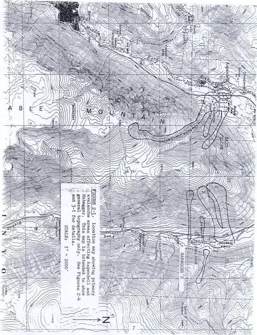
4 ~ 2.1 ASPENDELL DESCRIPTION 2 ASPENDELL Aspendell is a rural residential community with 162 developable lots and 85 single-family structures. Approximately 250 people inhabit the community at various times of the year. The community is located at an elevation of 8,400 feet, as shown on Figures 1-1 and 2-1. The earliest use of the area was by mining interests and the current Cardinal Lodge immediately south of Aspendell was the headquarters building for the mining company. The lodge is believed to have been converted to its present use in the early 1940'5. The Aspendell subdivision was conceptualized and s~urveyed for development in State Highway 168, a paved, 2-lane paved road, links Aspendell with Bishop, 19 highway miles to the east. Fire protection is provided by the Aspendell Volunteer Fire Department, and the community is served by a sewer and water service. Subdivision streets are paved to County standards and are maintained by the County. All utilities are underground. 2.2 AVALANCHE TERRAIN.~.. '. ) The community of Aspendell had been reached by avalanches originating in Jawbone (Hambone) Canyon and by avalanches starting on a steep WNW-facing slope immediately southeast of the community, (the "East Slope"). Either of these two avalanche areas can damage structures within developed areas or areas proposed for development within Aspendell. The avalanche areas are described below. Jawbone Canyon, referred to locally as "Hambone" Canyon, will accumulate deep windblown snow deposits on North-northeast- (NNE) facing slopes in the upper basin at lo,400-to-ll,000 feet elevation (Figure 2-1). This upper-basin terrain is the primary avalanche "starting zone," or area in which the unstable snowpack breaks loose and accelerates during avalanche conditions. During conditions of widespread snow instability, approximately 30 acres (300,000 yd3) of snow will release from this upper starting zone, accelerate down the canyon, and deposit snow and debris on the alluvial fan upon which a portion of Aspendell is located. The steep slope of the alluvial fan enables avalanches to advance for long distances, sometimes at moderate velocities. Avalanche-dynamics calculations conduc;':.ed for this study indicate that during design ("loo-year"j avalanche conditions, a maximum velocityof 95 mph will be obtained in the upper canyon, but the velocity will have decreased to 50 mph at the top of the alluvial fan, a short distance above the community. This "design- 6
5


, 1969, and 1986.")
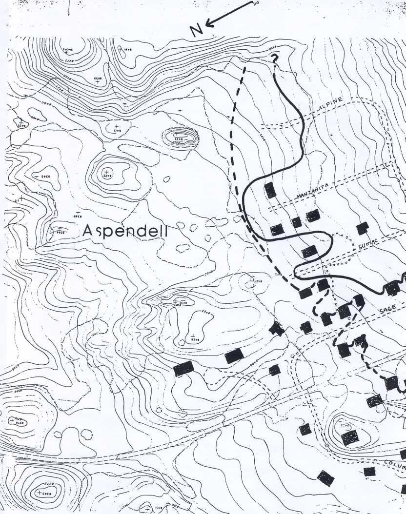
6 .,.;; avalanche" velocity was used to determine th.e sizes and placements of earthen avalanche defense structures as described in Section 2.5. The East Slope can produce two smaller avalanches which can enter the east portion of Aspendell. The two avalanche areas begin in steep bowl-shaped depressions in the terrain between 9,200 and 10,000 feet elevation, accelerate on the steep open slope and run out onto the relatively flat ground. Avalanches on the East Slope will not be as large as those produced in Jawbone Canyon, but they will attain a velocity sufficient to reach town and damage exposed structures. Avalanches from the East Slope may reach speeds in excess of loo mph on the steep slopes. Powder blast and low-density flowing snow will reach and potentially damage structures. As defined in the Aspendell, Habegger's, and Sage Flat areas, "historic" avalanche areas have been determined by two methods: a. From eyewitness accounts, photographs; newspaper articles, and -')... b. From unmistakable field evidence, such as damaged trees and distribution of old vegetation and other debris. Large avalanches are known to have occurred on the Aspendell alluvial fan in 1952 (approximately), 1969, and The 1952 avalanche predated the community, but is known to have crossed Highway 168 south of town. We have no eyewitness accounts of this avalanche reaching any of the presently-developed areas, but this is understandable because detailed observations of this area did not exist at the time. Because this avalanche crossed Highway 168, however, it does provide a minimum estimate of the runout potential immediately south of town. A large avalanche also occurred during the heavy snow winter of 1968/69. This avalanche reached the intersection of Alpine Drive and Sage Drive and damaged a house. Debris from this avalanche may also have reached the mailboxes on the west side of Highway 168. Although this avalanche may have reached other undeveloped portions of Aspendell and the terrain south of the community, we have no eyewitness accounts from these areas. A large avalanche also occurred on February 16, This avalanche is well documented by obselvations of several residents. One house south of Alpine Drive was destroyed (Figures 2-2 and 2-3) and three other houses on Sage Drive suffered minor damage. Avalanche debris blocked the intersection of Sage Drive and Alpine Drive and debris was transported nearly 3
 Canyon completely destroyed this")
,1 \" FIGURE 2-3.")
7 ...1 FIGURE 2-2. The February, 1986 avalanche from Jawbone (Hambone) Canyon completely destroyed this house on Alpine Drive and moved it at least 200 feet to the northwest. ),1 " FIGURE 2-3. This photograph, taken 2 months after the 1986 avalanche from Jawbone Canyon occurred, shows the complete destruction from avalanche impact and crushing. 9


 than the sqrrounding forest.")

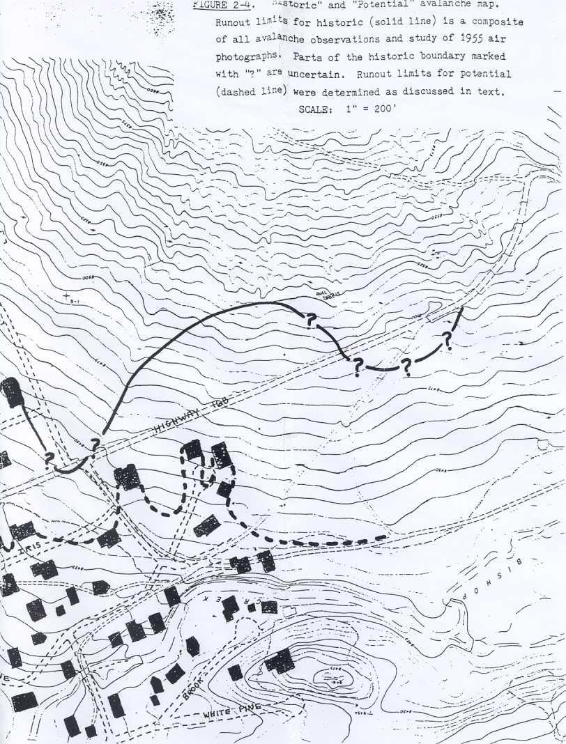
8 to the north end of Sumac Road. The historical record of avalanches from Jawbone Canyon was extended by a search of the alluvial fan for avalanche debris and by study of 1955 aerial photographs. The alluvial fan is littered with vegetative debris transported from higher elevations by avalanches. Debris was found on most of the fan, attesting to the fact that avalanches can be widespread. The debris is much more heavily concentrated on higher portions of the fan above the powerline, and becomes less distinct toward Highway 168. In planning the present Highway 168, Caltrans obtained aerial photographs of the alluvial fan in 1955, which predates construction of Aspendell east of the Highway. These photographs are of very high resolution, and when viewed in stereo, areas of avalanche runout into the aspen forest on the no~th side of Aspendell can be clearly distinguished. In particular, there exists several areas in which the aspen sizes are uniformly smaller (and younger) than the sqrrounding forest. This indicates a sudden removal of the forest and a gradual regrowth of the trees. These trees had not attained the size of the surrounding forest at the time of the photograph. The avalanche or avalanches determined through air photo study probably occurred at least 10 years before the 1955 photos. / The historic record of avalanches in Aspendell indicates that.three large avalanches occurred (1952, 1969, and 1986) and that at least one additional large avalanche before 1955 swept over the area that was to become Aspendell. The avalanche magnitude that has been observed, therefore, has an apparent "return period" of only 10 to 15 years, (4 events in roughly 40 to 50 years). The runout limits of all these avalanches have been combined on Figure 2-4, a 1" = 200' scale topographic map which was produced by Caltrans from the 1955 (pre-contruction) photos. We have superimposed the historic avalanche limits and present roads and houses on this photo. Building and road positions are correct :to within 0.15 inch (30 feet on the map scale). Avalanches which are larger than those documented are possible on the Jawbone Canyon alluvial fan. These avalanches will travel at least as far as the historic limits (Figure 2-4), but may also reach locations in which no documented evidence for past avalanches exists. This is true because no significant topographic barriers exist on the alluvial fan which may deflect or channelize avalanches. The Jawbone Canyon alluvial fan is typical of many small drainage basins that produce avalanches throughout the Sierra Nevada and other mountain ranges of the world. Alluvial fans, such as this 10
9
10
, therefore frictional resistance and gravitational forces may be")
 avalanches in the Eastern Sierra Nevada indicates that large avalanches similar to Jawbone Canyon usually flow in random and unpredictable")
11 j one, tend to disperse avalanches laterally into random directions because the fan surface lacks topographic barriers to flow. Furthermore, avalanches can travel for long distances because the fan surface is relatively steep (8 to 12 over much of the surface), therefore frictional resistance and gravitational forces may be nearly in balance. An area missed by avalanches during one event may be reached by the next one. Finally, a study of 90 "design-magnitude" ("loo-year") avalanches in the Eastern Sierra Nevada indicates that large avalanches similar to Jawbone Canyon usually flow in random and unpredictable directions and reach to the end of the alluvial fan. The potential avalanche determined runout limits, therefore, have been a. by study of avalanche performance in the Eastern Sierra Nevada, and b. through personal experience with the size and shape of major avalanche runouts on alluvial fans throughout the Sierra Nevada and other mountain areas. -'1." 'J These potential runout limits are also shown on Figure 2-4. The probability or return period of the "potential" avalanche runout can be estimated from the statistical data base of major avalanches obtained in the Sierra Nevada. Because the data base itself consists entirely of 100-year return period avalanches, and because this data base was used to infer the potential avalanche extent at Aspendell, then the potential avalanche runout must also have a 100 year return period (a constant 1% probability each year). This is an order-of-magnitude return period estimate. Ther"efore, the actual return period may lie between 30 and 300 years. A more accurate estimate of the return period cannot be made without a detailed historical record at least 200 years long. As shown on Figure 2-4, the potential runout distance is not significantly greater than the historic avalanche. The primary differences between the historic and potential runout limits are: a. The areas between the historic runouts are affected by the potential avalanche; b. The southwest part of Aspendell (near Cardinal Road), an area in which little historic data was obtained, is within the potential runout; and c. Avalanche runout from the into the east part of Aspendell. "East Slope" is mapped 12
e. Artificial avalanche release. This usually consists of delivering explosives to avalanche starting 2.5 AVALANCHE MITIGATION
 2.5 AVALANCHE MTGATON 2.5.1 General considerations Several alternative forms of avalanche mitigation are in use around the world. The selection of the best form of avalanche protection in a given area
DESIGN-MAGNITUDE AVALANCHE MAPPING AND MITIGATION ANALYSIS KIRKWOOD RESORT, CALIFORNIA -- AN UPDATED STUDY. Prepared For. Mr.
 0 ----- )11.eCtfS t QQ'7 0 f-ieceivel) P,mador County MAR 0 3 2003 PLANNING DEPARTMENT DESIGN-MAGNITUDE AVALANCHE MAPPING AND MITIGATION ANALYSIS KIRKWOOD RESORT, CALIFORNIA -- AN UPDATED STUDY Prepared
Typical avalanche problems
 Typical avalanche problems The European Avalanche Warning Services (EAWS) describes five typical avalanche problems or situations as they occur in avalanche terrain. The Utah Avalanche Center (UAC) has
NWAC Blog. Cornices - don't walk the line! Written by Robert Hahn on March 14, Last update on May 15, 2017.
 NWAC Blog Cornices - don't walk the line! Written by Robert Hahn on March 14, 2017. Last update on May 15, 2017. Human-triggered cornice fall avalanche from March 10th, 2017. The crown release exposed
THRESHOLD GUIDELINES FOR AVALANCHE SAFETY MEASURES
 BRITISH COLUMBIA MINISTRY OF TRANSPORTATION & INFRASTRUCTURE AVALANCHE & WEATHER PROGRAMS THRESHOLD GUIDELINES FOR AVALANCHE SAFETY MEASURES British Columbia Ministry of Transportation & Infrastructure
International Snow Science Workshop
 A PRACTICAL USE OF HISTORIC DATA TO MITIGATE WORKER EXPOSURE TO AVALANCHE HAZARD Jake Elkins Jackson Hole Mountain Resort, Teton Village, Wyoming Bob Comey* Jackson Hole Mountain Resort, Teton Village,
Guidelines for Snow Avalanche Risk Determination and Mapping. David McClung University of British Columbia
 Guidelines for Snow Avalanche Risk Determination and Mapping David McClung University of British Columbia Why do we need guidelines? Costs: 14 fatalities/year, $0.5 M/year property damage, $10 M/year avalanche
Proceedings, 2012 International Snow Science Workshop, Anchorage, Alaska
 I-90 SNOQUALMIE PASS: OPERATING A HIGHWAY AVALANCHE PROGRAM DURING A MAJOR CONSTRUCTION PROJECT John Stimberis, Washington State Department of Transportation ABSTRACT: Snoqualmie Pass, WA (921m) receives
Going-to-the-Sun Road, Glacier National Park, MT, USA Avalanche Path Atlas
 Going-to-the-Sun Road, Glacier National Park, MT, USA Avalanche Path Atlas Erich H. Peitzsch Daniel B. Fagre USGS Northern Rocky Mountain Science Center West Glacier, MT, USA Introduction... 2 Overview
Excelsior Pass Avalanche Accident January 1, 2008
 Excelsior Pass Avalanche Accident January 1, 2008 Accident Summary Time: 1 January 2008, approximately 13:00 hrs Location: Near Excelsior Pass to east of Church Mt, Northern Washington Cascades WA Activity:
2.0 Physical Characteristics
 _ 2.0 Physical Characteristics 2.1 Existing Land Use for the Project The site is comprised of approximately 114 acres bounded by Highway 101 to the north, the existing town of Los Alamos to the east, State
Mountain Goats and Winter Recreation November 17, 2011
 Mountain Goats and Winter Recreation November 17, 2011 Summary Mountain goats need protection from disruption and displacement in their winter feeding areas by motorized and non-motorized recreationists
STAFF REPORT. Airport Land Use Consistency Determination Betteravia Plaza. MEETING DATE: January 21, 2016 AGENDA ITEM: 8D
 STAFF REPORT SUBJECT: Airport Land Use Consistency Determination Betteravia Plaza MEETING DATE: AGENDA ITEM: 8D STAFF CONTACT: Andrew Orfila RECOMMENDATION: Adopt findings for the Betteravia Plaza project
Avalanches and the Mount Whitney Basin
 Avalanches and the Mount Whitney Basin 10 April 2006 by Bob Rockwell Prelude Avalanches are a fact of life in high mountains in winter, and we take courses to find out about them. We learn how to assess
Tahoe National Forest Over-Snow Vehicle Use Designation
 Tahoe National Forest Over-Snow Vehicle Use Designation USDA Forest Service Tahoe National Forest February 20, 2015 Introduction The Forest Service, U.S. Department of Agriculture will prepare an Environmental
Trail Assessment Report
 Trail Assessment Report Trail Options for the Bear Creek Canyon located in Pikes Peak Ranger District, Pike National Forest and on Colorado Springs Utility Lands Due to the presence of a unique species
Glaciers. Reading Practice
 Reading Practice A Glaciers Besides the earth s oceans, glacier ice is the largest source of water on earth. A glacier is a massive stream or sheet of ice that moves underneath itself under the influence
Jumbo Glacier Resort Master Plan Appendix 2-A
 Jumbo Glacier Resort Master Plan Appendix 2-A Avalanche Studies and Reports prepared by P. Schaerer of Stetham & Associates Pheidias Project Management Corp. Copyright June, 2005 JUMBO
LEVEL 1 - AVALANCHE OVERVIEW HANDOUT
 Bill Glude Alaska Avalanche Specialists 20111202 All photos and graphics Bill Glude unless otherwise noted. LEVEL 1 - AVALANCHE OVERVIEW HANDOUT Summary of Key Points Statistics 1 2 3 Urban Avalanches
Conservatory Roof Structural Information Guide
 Conservatory Roof Structural Information Guide Effective from March 2012 Now includes wide span capabilities Tel: 01623 443200 www.synseal.com Useful Information This guide displays data on the permissible
Lake Wissota Access Locations within the LaFayette Township. By Chad Martin
 Lake Wissota Access Locations within the LaFayette Township By Chad Martin Anson/ Wissota Access Point # 1 Road: 195 th St. Associated Fire Numbers: 13294 Defining Characteristics: Forested from road
Part 1: Introduction to Decision Making
 Part 1: Introduction to Decision Making 1.1 - Anatomy of a Decision ABOUT AIARE Learning Outcomes Identify that backcountry decision making involves five key components: Plan, Observe, Teamwork, Choose
Dallas Executive Airport
 648 DECLARED DISTANCE OPTION 1a DISPLACE 31 THRESHOLD BY 97 Considers RSA Limiting Factor No runway extensions 13 31 TORA 6,451 6,451 TODA 6,451 6,451 ASDA 5,958 6,451 LDA 5,958 6,354 Runway 17-35 (3,8
Non-motorized Trail Plan & Proposal. August 8, 2014
 Town of Star Valley Ranch, Wyoming and the Star Valley Ranch Association in partnership with the USDA Forest Service, Bridger-Teton National Forest, Greys River Ranger District Non-motorized Trail Plan
NOTICE OF INTENT MAPS WITH DESCRIPTIONS
 NOTICE OF INTENT MAPS WITH DESCRIPTIONS Location Map(s) to Accompany Notice of Intent The small corner map embedded in the lower left corner of the large map above shows the location of the three national
In southern Upper Valais a very high avalanche danger will be encountered in some regions Edition: , 08:00 / Next update: 9.1.
 Page 1/6 In southern Upper Valais a very high avalanche danger will be encountered in some regions Edition: 9.1.2018, 08:00 / Next update: 9.1.2018, 17:00 Avalanche danger updated on 9.1.2018, 08:00 region
BLASTING GLACIAL ICE AND SNOW ABSTRACT
 BLASTING GLACIAL ICE AND SNOW HERB BLEUER ABSTRACT This presentation, with the aid of slides, is about methods of blasting large quantities of glacial ice and snow. The project illustrated here involved
El Dorado County COMMUNITY WILDFIRE PROTECTION PLAN Community Tab for AUBURN LAKE TRAILS FIRE SAFE COUNCIL ACTIVITIES
 El Dorado County COMMUNITY WILDFIRE PROTECTION PLAN Community Tab for AUBURN LAKE TRAILS FIRE SAFE COUNCIL ACTIVITIES Prepared for Inclusion in the: EL DORADO COUNTY FIRE SAFE COUNCIL Community Wildfire
STAFF REPORT. Airport Land Use Plan Consistency Review: Santa Barbara Airport Master Plan. MEETING DATE: November 19, 2015 AGENDA ITEM: 7D
 STAFF REPORT SUBJECT: Airport Land Use Plan Consistency Review: Santa Barbara Airport Master Plan MEETING DATE: AGENDA ITEM: 7D STAFF CONTACT: Peter Imhof, Andrew Orfila RECOMMENDATION: Adopt findings
Theme: Predominately natural/natural appearing; rustic improvements to protect resources. Size*: 2,500 + acres Infrastructure**:
 Recreation Opportunity Spectrum (ROS) Classes The Recreation Opportunity Spectrum (ROS) provides a way to describe the variations in the degree of isolation from the sounds and influences of people, and
This section of the Plan provides a general overview of the Smoky Mountain Region. It consists of the following four subsections:
 SECTION 3 COMMUNITY PROFILE This section of the Plan provides a general overview of the Smoky Mountain Region. It consists of the following four subsections: 3.1 Geography and the Environment 3.2 Population
NOISE ABATEMENT PROCEDURES
 1. Introduction NOISE ABATEMENT PROCEDURES Many airports today impose restrictions on aircraft movements. These include: Curfew time Maximum permitted noise levels Noise surcharges Engine run up restrictions
Avalanche Hazard Investigations, Zoning, and Ordinances, Utah, Part 2
 Avalanche Hazard Investigations, Zoning, and Ordinances, Utah, Part 2 David A. Scroggin, Jack Johnson Company L. Darlene Batatian, P.G., Mountain Land Development ABSTRACT: The Wasatch Mountains of Utah
STAFF REPORT. Airport Land Use Plan Consistency Review: Old Town Village Mixed Use Project City of Goleta. MEETING DATE: June 18, 2015 AGENDA ITEM: 5M
 STAFF REPORT SUBJECT: Airport Land Use Plan Consistency Review: Old Town Village Mixed Use Project City of Goleta MEETING DATE: AGENDA ITEM: 5M STAFF CONTACT: Peter Imhof, Andrew Orfila RECOMMENDATION:
Specification for Grip blocking using Peat Dams
 Technical Guidance Note 1 Specification for Grip blocking using Peat Dams 1. Introduction Moorland drains (grips) have been dug across much of the Yorkshire upland peatlands. Many of these grips have become
MP : the top of the bottom switchback
 MP 237 238: the top of the bottom switchback For reference this section of U S Highway 40 has been called the top of the bottom switchback on the Grand County side of the Pass. It is here that the proposed
APPENDIX D: SUSTAINABLE TRAIL DESIGN. APPENDICES Town of Chili Parks and Recreation Master Plan Update
 APPENDIX D: SUSTAINABLE TRAIL DESIGN APPENDICES Town of Chili Parks and Recreation Master Plan Update Sustainable Trail Construction Sustainable trails are defined by the US Forest Service as trails having
GLACIER STUDIES OF THE McCALL GLACIER, ALASKA
 GLACIER STUDIES OF THE McCALL GLACIER, ALASKA T John E. Sater* HE McCall Glacier is a long thin body of ice shaped roughly like a crescent. Its overall length is approximately 8 km. and its average width
J. Oerlemans - SIMPLE GLACIER MODELS
 J. Oerlemans - SIMPE GACIER MODES Figure 1. The slope of a glacier determines to a large extent its sensitivity to climate change. 1. A slab of ice on a sloping bed The really simple glacier has a uniform
DRAFT GENERAL IMPLEMENTATION PLAN AND SPECIFIC IMPLEMENTATION PLAN MIDDLETON MUNICIPAL AIRPORT MOREY FIELD. Revised 12/12/03
 DRAFT GENERAL IMPLEMENTATION PLAN AND SPECIFIC IMPLEMENTATION PLAN MIDDLETON MUNICIPAL AIRPORT MOREY FIELD Revised 12/12/03 As recommended for approval by the Plan Commission General Project Description
Ski / Sled tracks as an expression of avalanche risk Jordy Hendrikx 1 & Jerry Johnson 2,1 1.
 Ski / Sled tracks as an expression of avalanche risk Jordy Hendrikx 1 & Jerry Johnson 2,1 1 Snow and Avalanche Laboratory, Montana State University, Bozeman, Montana, USA 2 Political Science, Montana State
Route #1) Mt. of the Holy Cross - North Ridge
 Mt. of the Holy Cross - North Ridge") Climbing 14ers can be very dangerous, please read the Mountaineering Safety Page and make sure you have a map+compass and can use them effectively, without the help of electronic devices. Route #1) Mt.
Climbing 14ers can be very dangerous, please read the Mountaineering Safety Page and make sure you have a map+compass and can use them effectively, without the help of electronic devices. Route #1) Mt.
SNOW AVALANCHES IN PROVO CANYON, UTAH
 SNOW AVALANCHES IN PROVO CANYON, UTAH KEVIN GRIFFITH REGION THREE AVALANCHE FORECASTER UTAH DEPARTMENT OF TRANSPORTATION 825 NORTH 900 WEST OREM, UTAH 84057-3958 USA (801 )-227-8000 TEL (801 )-227-8049
MP : Blue Hill and the Disney Avalanche Path
 MP 252-253: Blue Hill and the Disney Avalanche Path This section of the Auto Tour includes a portion of the wagon road, one of Colorado s most famous avalanches and the remains of an old dam. Route Mile
SOUTH INTERCHANGE AREA
 Santaquin City General Plan 1 Location and Characteristics The South Interchange Area of Santaquin is located west of Interstate 15 and south of 500 South (Figure 1). It includes properties already annexed
SLOPE CALCULATION. Wilderness Trekking School 1
 SLOPE CALCULATION By Joe Griffith, February 2014 Objectives Upon completion of this chapter, you will be able to: Read the rise-over-run from a topographic map. Convert the rise-over-run into a slope angle
TEACHER PAGE Trial Version
 TEACHER PAGE Trial Version * After completion of the lesson, please take a moment to fill out the feedback form on our web site (https://www.cresis.ku.edu/education/k-12/online-data-portal)* Lesson Title:
AVALANCHE TERRAIN. Bill Glude Alaska Avalanche Specialists All photos and graphics Bill Glude unless otherwise noted.
 Bill Glude Alaska Avalanche Specialists 20111202 All photos and graphics Bill Glude unless otherwise noted. AVALANCHE TERRAIN The Key Questions 1.) Could the terrain produce an avalanche?! a.) Where you
Structural Avalanche Defenses Chris Wilbur, P.E. Wilbur Engineering, Inc. SW Colorado Chapter ASCE February 15, 2012
 Structural Avalanche Defenses Chris Wilbur, P.E. Wilbur Engineering, Inc. SW Colorado Chapter ASCE February 15, 2012 Outline Design Avalanche Types of Structures Deflecting/Diversion Dams & Retarders Snowsheds
SYNOPSIS WEATHER AND SNOWPACK
 Peak 6996 Avalanche Fatality Incident Report Glacier National Park, MT Date of Avalanche: 31 March 2010 Date of Investigation: 2 April 2010 Investigation Team: Erich Peitzsch (USGS), Ted Steiner (Chugach
Logo Department Name Agency Organization Organization Address Information 5700 North Sabino Canyon Road
 Logo Department Name Agency Organization Organization Address Information United States Forest Coronado National Forest 5700 North Sabino Canyon Road Department of Service Santa Catalina Ranger District
Chapter 2: El Dorado County Characteristics and Demographics
 Chapter 2: El Dorado County Characteristics and Demographics 2.1 Geographic Area and Demographics El Dorado County comprises 1,805 square miles with over half of the area in the Eldorado National Forest
Avalanche danger high in parts of NCW
 3/23/2017 Avalanche danger high in parts of NCW THURSDAY, MARCH 23, 2017 Avalanche danger high in parts of NCW by Christine Pratt Public Safety Feb. 9, 2017, 4:52 p.m. Photo provided An avalanche hit the
Trail Use in the N.C. Museum of Art Park:
 Trail Use in the N.C. Museum of Art Park: New Connections, New Visitors Jacqueline MacDonald Gibson, PhD Daniel Rodriguez, PhD Taylor Dennerlein, MSEE, MCRP, EIT Jill Mead, MPH Evan Comen University of
Preliminary Site Evaluation
 Preliminary Site Evaluation 100 Acre Site, US 72 Piperton, Tennessee Power Distributor: Chickasaw Electric Cooperative August 2010 SITE DATA SHEET PIPERTON US 72 SITE (100 ACRES): LOCATION & GENERAL DESCRIPTION
CHAPTER FIVE PROSPECTS FOR FUTURE ECONOMIC DEVELOPMENT
 CHAPTER FIVE PROSPECTS FOR FUTURE ECONOMIC DEVELOPMENT 5.1 GENERAL The recommended type and location of future land uses in Alpine should, in part, consider potential opportunities for future economic
Northern Rail Extension, Phase One
 General Project and Funding 1. Where does Phase One start? The rail line for Phase One begins roughly at the northern boundary of the former Bradbury property, but also includes work along Tom Bear Trail
CHAPTER 4 -- THE LAND USE PLAN: DESCRIPTIONS AND POLICIES FOR THIRTEEN PLANNING AREAS
 CHAPTER 4 -- THE LAND USE PLAN: DESCRIPTIONS AND POLICIES FOR THIRTEEN PLANNING AREAS NORTH CENTRAL CAC AREA LITTLE VALLEY ROAD TO JUG HANDLE CREEK PLANNING AREA This planning area includes Cleone, Noyo,
along a transportation corridor in
 Rockfall hazard and risk assessment along a transportation corridor in the Nera Valley, Central Italy Presentation on the paper authored by F. Guzzetti and P. Reichenbach, 2004 Harikrishna Narasimhan Eidgenössische
DAMAGE ASSESSMENT OF SAND FENCING GARDEN CITY, NORTH LITCHFIELD AND LITCHFIELD BEACH GEORGETOWN COUNTY, SC
 OF SAND FENCING GARDEN CITY, NORTH LITCHFIELD AND LITCHFIELD BEACH GEORGETOWN COUNTY, SC June 07, 2017 PREPARED FOR: GEORGETOWN COUNTY DEPARTMENT OF PUBLIC SERVICES PREPARED BY: The EARTHWORKS Group 11655
Avalanche Awareness and Leading a Companion Rescue
 Avalanche Awareness and Leading a Companion Rescue Introduction: Traveling in the backcountry is a great way to enjoy the outdoors and friends. It s important that when we travel in the backcountry we
Alternative Highest & Best Use Analysis Boutique Hotel
 Alternative Highest & Best Use Analysis In response to numerous comments received from the public, as well as issues raised by the CCC in the Appeal Staff Report Substantial Issue Determination, the following
Henderson Mountain Avalanche Accident Two riders caught, one partially buried, one fully buried
 Henderson Mountain Avalanche Accident Two riders caught, one partially buried, one fully buried Custer-Gallatin National Forest 28 November 2014 Synopsis A group of 6 or 7 snowmobilers (part of a larger
b. Minimum Site Area. Recreational vehicle parks shall be located on a parcel of land not less than 3 acres in area.
 6450 RECREATIONAL VEHICLE PARK REGULATIONS 6450 TITLE AND PURPOSE. The provisions of Section 6450 through 6499, inclusive, shall be known as the Recreational Vehicle Park Regulations. The purpose of these
HYDROLOGY OF GLACIAL LAKES, FORT SISSETON AREA
 PROC. S.D. ACAD. SCI., VOL. 77 (1998) 59 HYDROLOGY OF GLACIAL LAKES, FORT SISSETON AREA Perry H. Rahn Department of Geology & Geological Engineering South Dakota School of Mines and Technology Rapid City,
Santa Cruz North Interior
 Santa Cruz North Interior The Santa Cruz North Interior planning area includes the area commonly referred to as the San Lorenzo Valley. The greatest amount of development occurs in the communities of Boulder
II. GENERAL DESCRIPTION OF ENVIRONMENTAL SETTING
 II. GENERAL DESCRIPTION OF ENVIRONMENTAL SETTING A. LOCATION AND BOUNDARIES The proposed Canyon Hills project site is located at 8000 West La Tuna Canyon Road in the City of Los Angeles (the City ). The
RE: Extreme Avalanche Hazard at New Jumbo Glacier Resort (JGR) Daylodge Building Site
 Daylodge Building Site") To: Ms. Autumn Cousins Manager, Policy and Compliance BC Environmental Assessment Office, via Email to autumn.cousins@gov.bc.ca and eao.compliance@gov.bc.ca PO Box 9426 Stn Prov Govt Victoria, BC V8W 9V1
To: Ms. Autumn Cousins Manager, Policy and Compliance BC Environmental Assessment Office, via Email to autumn.cousins@gov.bc.ca and eao.compliance@gov.bc.ca PO Box 9426 Stn Prov Govt Victoria, BC V8W 9V1
URBAN DESIGN REPORT. Proposed Residential Development, Old Church Road, Caledon East
 Proposed Residential Development, Old Church Road, Caledon East TABLE CONTENTS: 1.0 DEVELOPMENT 1.1 Introduction-Analysis of Guiding Principles and Documents 1.2 Community Design and Architectural Design
GOLDEN EARS PROVINCIAL PARK
 GOLDEN EARS PROVINCIAL PARK Trail Information as of October 10 th 2015 Do not underestimate the mountainous wilderness of Golden Ears Provincial Park. The combination of rugged terrain and rapidly changing
Proceedings, International Snow Science Workshop, Breckenridge, Colorado, 2016 ANALYSIS OF UTAH AVALANCHE FATALITIES IN THE MODERN ERA
 ANALYSIS OF UTAH AVALANCHE FATALITIES IN THE MODERN ERA Drew Hardesty 1 * 1 Utah Avalanche Center ABSTRACT: The Utah Avalanche Center (UAC) has records of Utah avalanche fatalities for the modern era,
APPENDIX E LYONS PARK ESTATES DETAILED COMMUNITY ASSESSMENT RESULTS
 # Houses: 65 APPENDIX E LYONS PARK ESTATES DETAILED COMMUNITY ASSESSMENT RESULTS Overall Risk Assessment: High Description: Lyons Park Estates is located on the foothills south of the town of Lyons on
Chapter 4.0 Alternatives Analysis
 Chapter 4.0 Alternatives Analysis Chapter 1 accumulated the baseline of existing airport data, Chapter 2 presented the outlook for the future in terms of operational activity, Chapter 3 defined the facilities
The Roots of Carrying Capacity
 1 Applying Carrying Capacity Concepts in Wilderness 1872 1964...shall be preserved for the use & enjoyment of the American people...in such manner as will leave them unimpaired for future generations...
Snowmobile Trail Signing REF: DNR Trail Signing Handbook
 AWSC FALL WORKSHOP TRAIL SIGNING & MAINTENANCE NOVEMBER 5, 2011 Workshop presenters: Larry Erickson, AWSC Trails Committee Chairman, Iron County Director Dave Peterson, Langlade County Director Snowmobile
Proceedings, International Snow Science Workshop, Breckenridge, Colorado, 2016
 AVALANCHE FORECASTING AND MESSAGING FOR UNUSUAL AVALANCHE CONDITIONS IN A MARITIME SNOW CLIMATE-BURIED SURFACE HOAR INTERNATIONAL SNOW SCIENCE WORKSHOP 2016 IN BRECKENRIDGE, CO Steve A. Reynaud Sierra
A GIS Analysis of Probable High Recreation Use Areas in Three Sisters Wilderness Deschutes and Willamette National Forests
 Lindsey Kiesz Geo 565 Term Project 3/15/2010 A GIS Analysis of Probable High Recreation Use Areas in Three Sisters Wilderness Deschutes and Willamette National Forests Introduction The Three Sisters Wilderness
Comparison Between Old and New ALUC Plans
 A P P E N I X H Comparison Between Old and New ALUC Plans OVERVIEW This Placer County Airport Land Use Compatibility Plan (ALUCP) sets forth land use compatibility criteria for the environs of Auburn Municipal,
The Potentially Dangerous Glacial Lakes
 Chapter 11 The Potentially Dangerous Glacial Lakes On the basis of actively retreating glaciers and other criteria, the potentially dangerous glacial lakes were identified using the spatial and attribute
Subject to sale, withdrawal, or error.
 The Crawford L Bar Ranch is located approximately 40 air miles west of Albuquerque, New Mexico. This ranch truly epitomizes the description of New Mexico being the Land of Enchantment. The topography and
Access to the site is obtainable from the paved driveway leading to the MWD facility.
 County of Riverside Public Safety Enterprise Communication Project Appendix A: Candidate Site Descriptions Overview The site is located adjacent to a Metropolitan Water District (MWD) facility on El Sobrante
Loveland Valley Lodge Expansion Environmental Assessment Recreation Resource Report
 United States Department of Agriculture Forest Service Loveland Valley Lodge Expansion Environmental Assessment Recreation Resource Report Clear Creek Ranger District, Arapaho National Forest, Clear Creek
Route #2) Mt. Massive - Southwest Slopes
 Mt. Massive - Southwest Slopes") Route #2) Mt. Massive - Southwest Slopes Difficulty: Class 2 Ski: Advanced, D6 / R2 / III Exposure: Summit Elevation: Trailhead Elevation: Elevation Gain: Round-trip Length: Trailhead: County Sheriff:
Route #2) Mt. Massive - Southwest Slopes Difficulty: Class 2 Ski: Advanced, D6 / R2 / III Exposure: Summit Elevation: Trailhead Elevation: Elevation Gain: Round-trip Length: Trailhead: County Sheriff:
PRESENTS A RARE AND UNIQUE DEVELOPMENT OPPORTUNITY THE HISTORIC WHITE CHIEF LODGE FISH CAMP, CALIFORNIA
 MVP COMMERCIAL Hotel-Motel and Investment Brokerage PRESENTS John R. Reed, CCIM P. O. Box 338 Oakhurst, CA 93644 559.683.7474 Voice 559.683.7393 Fax 559.288.2488 Cell A RARE AND UNIQUE DEVELOPMENT OPPORTUNITY
Kit Carson-Challenger Ridge Trail Project
 Kit Carson-Challenger Ridge Trail Project Project Accomplishments Report-USFS December 15, 2015 Photo courtesy of Justin Peterson 815 South 25 th Street, Suite 101 Colorado Springs, CO 80904 Dedicated
II. THE BOULDER CREEK DRAINAGE BASIN
 II. THE BOULDER CREEK DRAINAGE BASIN This section provides an overview of the watersheds and flood hazards associated with Boulder Creek and South Boulder Creek including descriptions of the drainage basins,
Proceedings, International Snow Science Workshop, Breckenridge, Colorado, 2016
 THE WHITE PASS AND YUKON ROUTE AVALANCHE PROGRAM, FORECASTING AND RISK MAN- AGEMENT FOR A HISTORICAL RAILROAD Bill Glude Alaska Avalanche Specialists, Juneau, AK The White Pass and Yukon Route (WPYR) is
Sawtooth National Forest Fairfield Ranger District
 United States Department of Agriculture Forest Service Sawtooth National Forest Fairfield Ranger District P.O. Box 189 Fairfield, ID. 83327 208-764-3202 Fax: 208-764-3211 File Code: 1950/7700 Date: December
Geography 120, Instructor: Chaddock In Class 13: Glaciers and Icecaps Name: Fill in the correct terms for these descriptions: Ablation zone: n zne:
 Geography 120, Instructor: Chaddock In Class 13: Glaciers and Icecaps Name: Fill in the correct terms for these descriptions: Ablation zone: The area of a glacier where mass is lost through melting or
At the time, the portion of the line through Eagle County remains wholly under the ownership of Union Pacific Railroad (UP).
.") Chapter 5 The Railroad Corridor as a Trail Corridor The intent of this chapter is to identify how the rail corridor, if available for lease or purchase in all or part, could be incorporated into the core
Chapter 5 The Railroad Corridor as a Trail Corridor The intent of this chapter is to identify how the rail corridor, if available for lease or purchase in all or part, could be incorporated into the core
CHAPTER 4 -- THE LAND USE PLAN: DESCRIPTIONS AND POLICIES FOR THIRTEEN PLANNING AREAS
 CHAPTER 4 -- THE LAND USE PLAN: DESCRIPTIONS AND POLICIES FOR THIRTEEN PLANNING AREAS SOUTH COAST CAC PLANNING AREA 4.10 NAVARRO RIVER TO MALLO PASS CREEK PLANNING AREA (Includes Greenwood/Elk) This planning
5 MAP SPECIFICATION FOR SKI-ORIENTEERING
 5 MAP SPECIFICATION FOR SKI-ORIENTEERING 5.1 General Maps for ski orienteering are based on the specifications for foot-orienteering maps. However in order to meet the specific requirements put on the
Preferred Recreation Recommendations Stemilt-Squilchuck Recreation Plan March 2018
 Preferred Recreation Recommendations Stemilt-Squilchuck Recreation Plan March 2018 Below are the recommended recreation ideas and strategies that package together the various recreation concepts compiled
Twin Lakes Avalanche Incident 1/31/2016
 Twin Lakes Avalanche Incident 1/31/2016 Location: Place State Published by: Dave Bingaman (PAC), George Halcom (PAC), and Kent May (PAC) Twin Lakes, Salmon River Mountains Idaho Date 01/31/2016 Time Summary
RIO VISTA MUNICIPAL AIRPORT
 DRAINAGE TECHNICAL MEMORANDUM RIO VISTA MUNICIPAL AIRPORT RIO VISTA, CALIFORNIA Prepared for: City of Rio Vista 1 Main Street Rio Vista, CA 94571 (707) 374-5337 Prepared by: August 2012 Copyright 2012
Preliminary Findings of Proposed Alternative
 Preliminary Findings of Proposed Alternative The attached drawing provides a schematic layout of the proposed alternative that will be discussed on July 27, 2010. A full report will follow and should be
SHEET PILE WALLS A SPACE-SAVING AVALANCHE DEFENCE STRUCTURE
 SHEET PILE WALLS A SPACE-SAVING AVALANCHE DEFENCE STRUCTURE ÁRNI JÓNSSON, ORION Consulting Engineers * ERIK HESTNES, Norwegian Geotechnical Institute** ABSTRACT: Steel sheet piles, primarily used as retaining
Aspen Skiing Company Policy for Use of Other Power-Driven Mobility Devices And Service Animals
 Aspen Skiing Company Policy for Use of Other Power-Driven Mobility Devices And Service Animals Introduction New rules under the Americans with Disabilities Act (ADA), Titles II and III, went into effect
Section 3-04 Cross Sectional Elements TABLE OF CONTENTS. INTRODUCTION...3 General...3 Exhibit 1-Cross-Sectional Elements...3
 Section 3-04 Cross Sectional Elements TABLE OF CONTENTS INTRODUCTION...3 General...3 Exhibit 1-Cross-Sectional Elements...3 CROSS-SECTIONAL ELEMENTS...3 Traveled Way...3 Shoulder...3 Surfacing Taper...3
NORTH CASCADE SLACIER CLIMATE PROJECT Director: Dr. Mauri S. Pelto Department of Environmental Science Nichols College, Dudley MA 01571
 NORTH CASCADE SLACIER CLIMATE PROJECT Director: Dr. Mauri S. Pelto Department of Environmental Science Nichols College, Dudley MA 01571 INTRODUCTION The North Cascade Glacier-Climate Project was founded