Proceedings, International Snow Science Workshop, Breckenridge, Colorado, 2016
|
|
|
- Timothy Juniper Floyd
- 5 years ago
- Views:
Transcription

1 THE WHITE PASS AND YUKON ROUTE AVALANCHE PROGRAM, FORECASTING AND RISK MAN- AGEMENT FOR A HISTORICAL RAILROAD Bill Glude Alaska Avalanche Specialists, Juneau, AK The White Pass and Yukon Route (WPYR) is a narrow gauge railroad built in 1898 during the Klondike Gold Rush. Considered impossible to build by many who studied the route, it was blasted through the Coast Range from Skagway, Alaska to Whitehorse, Yukon Territory in only 26 months, and is a designated International Historic Civil Engineering Landmark. The WPYR suspended operations in 1982 when the Yukon s mining industry collapsed due to low mineral prices. The railway was reopened in 1988 as a seasonal tourism operation and today is Alaska s most popular shore excursion, carrying over 390,000 cruise ship passengers during the tourism season. The route to the White Pass goes through 17 major avalanche paths and numerous minor zones. In the early days, as was typical for the time, there was no avalanche program beyond relying on the experience and historical knowledge of the crews. Crews now begin snow-clearing operations at the end of March, and summer passenger operations begin with the arrival of the first ships in late April, while avalanche season runs through through mid-may, and can run into June. In 2007, Alaska Avalanche Specialists was called in to do an annual springtime snowpack evaluation. In 2015, as part of a system-wide risk management upgrade, operations transitioned to a modern avalanche program with crew training, daily forecasts and observations, regular fieldwork, closures and work area restrictions, and helicopter and hand blasting as necessary. KEYWORDS: railroad, avalanche program, Alaska, Yukon. 1. IHISTORY The White Pass and Yukon Route (WPYR) is a narrow gauge railroad built in 1898 during the Klondike Gold Rush. Considered impossible to build by many who studied the route, it was blasted through the Coast Range from Skagway, Alaska to Whitehorse, Yukon Territory in only 26 months, and is a designated International Historic Civil Engineering Landmark. The Klondike Highway, crossing the White Pass on the opposite side of the valley, opened in The WPYR suspended operations in 1982 when the Yukon s mining industry collapsed due to low mineral prices, and trucks now haul the ore. The railway reopened in 1988 as a seasonal tourism operation and today is Alaska s most popular shore excursion, carrying over 390,000 cruise ship passengers during the tourism season. A WPYR train awaits cruise ship passengers on the Railroad Dock. Most tours use these dieselelectric locomotives * Corresponding author address: Bill Glude, Alaska Avalanche Specialists, PO Box 22316, Juneau, Alaska, USA; tel: ; aas07@me.com 1364


2 The railroad currently operates only during the summer tourist season. The avalanche program begins in late March or early April, when crews begin clearing the tracks. The railroad opens for summer business in late April with the arrival of the first cruise ships. Avalanche season ends when the snowpack at starting zone elevations thaws and makes the transition to settled early summer conditions that no longer produce large avalanches. This typically happens in mid-may, but avalanches have reached the tracks as late as June when snows are heavy and spring is late. The WPYR maintains two steam locomotives that run several trips weekly. 2. AVALANCHE ISSUES 3. AVALANCHE PROGRAM In 2007, Alaska Avalanche Specialists was called in to do an annual springtime snowpack evaluation. In 2015, as part of a system-wide risk management upgrade after a trainload of passengers was caught between two slides in the spring of A bulldozer begins clearing fresh avalanche debris from the 15.2 Mile Path in May Snowpit for field snow studies, with snow profile, temperature, and density set up for measurement. The route to the White Pass summit goes through about 17 major paths, and numerous minor zones. The first and most active zone, with the largest and by far the most active paths, is from 12 Mile to 16 Mile (19 to 26 km), in the Glacier area. After the 16 Mile (26 km) Tunnel, there is a short stretch with minimal avalanche terrain, and then from Inspiration at 17 Mile (27 km) to the White Pass summit at Mile 20.4 (39 km) there are many short banks and rocky areas that send avalanches onto the tracks. The avalanche program and its fieldwork currently are limited to the United States side of the border, which lies at the summit of the pass. This has been workable in the recent low and moderatesnow years, but we are seeking international work permits for heavier-snow years or longer seasons. 2013, we went to a modern avalanche program with crew training, daily forecasts and observations, regular fieldwork, closures and work area restrictions, and helicopter and hand blasting as necessary. We evaluated a full range of avalanche mitigation techniques, but a combination of closures, work protocols, and explosives delivery by helicopter, with limited use of sled charges lowered on a rope,proved to be the practical solutions for seasonal operations. We are looking into adding a portable mortar system for the Slippery Rock Path, which is too steep and icy for helicopter or sled charges; and are considering a deflection berm for the late-running South Glacier Gully path. Staffing is minimal: one AAS lead avalanche forecaster (minimum of 10 years of experience and 1365


3 training), supplemented with experienced local backcountry travelers as seconds for field days. Our forecaster is stationed in Skagway and uses train, road, and helicopter access, plus ski and splitboard, for snowpack evaluation and avalanche mitigation. 6. AVALANCHE MAPS AND PHOTOS 6.1. Glacier Paths Map The Glacier area paths are the largest and most active along the route. The 12 Mile paths have only been recorded as reaching the tracks once, in a very snowy winter, and are not a problem in the spring. The main Glacier Area paths at 13.6 and 13.8 Mile, South Glacier Gully, Box Canyon, 15, 15.2 and 15.3 Mile, and Slippery Rock are the largest and most active group. USGS base map South Glacier Paths Photomap 4. ROUTE MAP The currently active WPYR route from Skagway, Alaska to Carcross, Yukon Territory, with major avalanche areas identified. Trains are not currently operating on the Carcross to Whitehorse portion of the railroad. Apple Maps base. 5. AVALANCHE HISTORY Doug Fesler generously contributed a database of 899 avalanche occurrences compiled from WPYR maintenance records over the 83 year period of operation from 1899 through Records are most complete on the US side, and are known to underrepresent activity on the Canadian side. Carcross maintenance foreman Willy Scheffler verbally contributed his 55 years of knowledge of paths on the Lake Bennett section. The South Glacier area has the largest paths on the route, but they hit the tracks far less often than the North Glacier paths. They have only 5 hits in the historical database. Facing north, they run later into the season than those on the opposite side of the valley Mile, 13.8 Mile, and the West Apron Slabs all have large granite rock slabs that produce an annual cycle of glide avalanches in the spring. The nearly 1800 m high, steep, and shaded starting zones above the Main Gully have hit the tracks with big debris as late as June. 1366

, the whole hillside can produce slides, but the principal and most active paths are labeled.")
4 6.3. North Glacier Paths Photomap The North Glacier paths are by far the most active paths on the route, with 674 occurrences in the historical database, peaking at 258 in April, and active through May, with 82 slides recorded. They are steep, with high starting zones, but due to their south aspect, they wet out and finish their spring cycles earlier than the paths across the valley. The tracks cross them high in the runout zones, so even moderate size avalanches put snow and rocks from the steep hillside on the tracks. The Glacier North path is less frequent than the others, but can hit the tracks. Going north (left), the whole hillside can produce slides, but the principal and most active paths are labeled. Box Canyon regularly hits the tracks, with 43 slides in the database, and the path group that includes 15.0, 15.2, and 15.3 Mile is the most active on the route, with 467 slides in the database. Slippery Rock is a big, frequent-running granite slab with 148 slides in the database. It releases snow and ice directly onto the tracks, and is difficult to hit with helicopter-delivered charges due to its steepness and proximity to the tracks Hannon Shed Area Paths There are many banks that produce avalanches onto the tracks between Inspiration and White Pass, with 205 slides recorded in the area, and peak activity in March, April, and May. The Hannon Shed Path is a notable producer of large slides with the consequence of a steep drop into Deadhorse Gulch below. The prevailing southerly storm winds (right to left in the photo) build cornices on the right side and load the slopes below. Pieces of cornice falling off are the usual triggers, and the broad gully holds substantial snow volume. The name comes from a wooden snowshed that used to help protect the tracks here Lake Bennett Paths Map The avalanche program does not currently cover the paths on the Canadian side. This is a lowersnow area than the coastal side of the White Pass, and the paths have generally all run and stabilized by the time track crews reach them in the spring, but they merit caution in heavy snow or late springs, and if winter operations ever resume. The paths named on this map are the ones with known avalanche history. Other paths that usually stop above the tracks, but may have potential to hit them, are indicated by their outlines. 1367


5 This path in the yard just south of Bennett, and its twin just to the north, have a history of hitting the tracks and moving whatever is parked in their way. The 5 slides recorded probably underrepresent activity there, according to WPYR crews Mile Path This path is not large, but has one slide in the database and is known to the maintenance crew for putting slide debris on the tracks Mile Path This is the most active path on the Lake Bennett section of the route. It only has three slides in the 6.6. Bennett Paths 1368


6 database, but maintenance crews say large slides on it are annual events. Both branches of the main path just right of center have a history of frequent large avalanches hitting the tracks. The path on the left is not known to hit the tracks, but appears to have the potential Scheffler and 50 Mile Paths hit and is known to maintenance crews for slides. It is the northernmost avalanche path on the route. 7. STAFF TRAINING A key component of the avalanche program is annual training for the track clearing crews in late March, for the office and management staff in early April, and for summer train crews as they arrive in late April. 8. AVALANCHE FORECASTING PROGRAM 8.1. Forecast Program Overview The daily forecasting program is the heart of the WPYR Avalanche Program. Observations are daily; fieldwork daily when conditions are active, every second or occasionally third day when not. Forecasting is the basis for setting work protocols, closures, and best timing for avalanche blasting. The Scheffler Path on the right has two recorded hits, the 50 Mile Path on the left has four, and maintenance crews know both as producers. The smaller drainages between have no record of reaching the track, but may do so in big years Pennington Path This path just south of Pennington has a long runout to reach the tracks, but has one recorded One of our standard burlap-bagged 12.5 kg ANFO charge, with 2m double cap and fuse, drops from the helicopter. The avalanche program has two distinct phases. The first is during the track-clearing season, an industrial program for a small crew of WPYR employees, generally beginning around April 1. The second is during the operating season, when we carry the general public in addition to our own crews. Passenger trains begin with the arrival of the first cruise ship, generally around the last week of April, with only one or two days of trains in the first two weeks, then multiple trains six to seven days a week, beginning in the first week of May. The avalanche program usually wraps up by midmay, but the 1800 m, north-facing Glacier South Gully path has put snow on the tracks in June, so the program continues as long as there is a threat. 1369


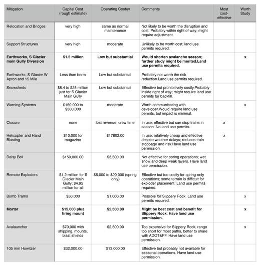
7 WPYR Avalanche Forecast Issued 0600 Tuesday, April 14, 2016 by Bill Glude Valid through 0600 Wednesday, April 14, 2016 WEATHER: We have +2 breaking skies, and wind S 3-5 m/s in town this morning. The SOT station on the pass reports -3 with S5-8 m/s; Summit Creek has -4, and Fraser has -4 with S4-6 m/s and mostly clear skies on the webcam. We expect continued clearing today, with thawing conditions in the afternoon, and moderate south winds in the 5-8 m/s range. AVALANCHE: We are on Moderate today, with an increasing trend in the afternoon as the snow thaws on solar aspects. Watch for the usual spring bank sluffs between Inspiration and the pass, glide avalanches on the slopes above Glacier, and ongoing small were stuffs on the slopes above Glacier. Slides are not expected to reach the tracks, except for bank stuffs above Inspiration. PLAN: We will be taking the work train for fieldwork above Inspiration today, monitoring the progress of the spring thaw. Sample forecast front page. The avalanche forecast goes out by 06:30 each day, and the forecaster briefs crews during the morning meeting. Forecasts are ed to a distribution list. The format is intended to offer some education on weather analysis, avalanche behavior, and the thinking behind the forecast; in addition to being a simple summary. The format we have been using is: Front page summary weather outlook snow stability and likely effect of predicted weather; work protocols if any speedometer icons for danger level, probability, size, and trend avalanche crew plan for the day Detailed analysis on following pages current weather, in town and on the pass summary of previous day s observations and fieldwork, if any summary and discussion of National Weather Service (NWS) zone forecast for today and tomorrow US Navy GFS weather model images and discussion for today and tomorrow discussion of other forecast model and tool results; our best value-added forecast Forecasts can also be broken out by the main zones: South of Glacier, North of Glacier, Hannon Shed Area, and Cutbanks from Inspiration to Summit, as needed Weather Data Sources We are fortunate to have a good existing network of weather stations and webcams already operating in the area, saving us from the need to install and maintain our own: White Pass ADOT&PF RWIS weather station Summit Creek Yukon Avalanche Center weather station Fraser Yukon Avalanche Center weather station Fraser highway weather station and webcam. Moore Creek SNOTEL weather station. Skagway Airport observations. We also share information with a network of avalanche forecasters working in the area Alaska DPT&PF forecaster. Yukon Avalanche Center forecasters. Yukon Highways forecaster. Yukon Heliski. Alaska Heliskiing, in Haines. SEABA Heliskiing, in Haines. 9. REFERENCES Fesler, D.: White Pass and Yukon Route entries from Alaska Historical Avalanche Database; personal communication.. Glude, Bill, Alaska Avalanche Specialists, Operations Plan, White Pass and Yukon Route Avalanche Program, 2016, internal document. Scheffler, Willy, White Pass and Yukon Route Carcross maintenance supervisor for 55 years; oral communications, 2016 White Pass and Yukon Route website history; 10.MITIGATION OPTIONS CONSIDERED The table on the next page summarizes the other mitigation options that were evaluated, with the two that most merit further consideration, a mortar for the Slippery Rock path, and a diversion berm for the South Glacier Main Gully path, in bold. 1370
8 1371
LEVEL 1 - AVALANCHE OVERVIEW HANDOUT
 Bill Glude Alaska Avalanche Specialists 20111202 All photos and graphics Bill Glude unless otherwise noted. LEVEL 1 - AVALANCHE OVERVIEW HANDOUT Summary of Key Points Statistics 1 2 3 Urban Avalanches
SYNOPSIS WEATHER AND SNOWPACK
 Peak 6996 Avalanche Fatality Incident Report Glacier National Park, MT Date of Avalanche: 31 March 2010 Date of Investigation: 2 April 2010 Investigation Team: Erich Peitzsch (USGS), Ted Steiner (Chugach
MP : the top of the bottom switchback
 MP 237 238: the top of the bottom switchback For reference this section of U S Highway 40 has been called the top of the bottom switchback on the Grand County side of the Pass. It is here that the proposed
Typical avalanche problems
 Typical avalanche problems The European Avalanche Warning Services (EAWS) describes five typical avalanche problems or situations as they occur in avalanche terrain. The Utah Avalanche Center (UAC) has
THRESHOLD GUIDELINES FOR AVALANCHE SAFETY MEASURES
 BRITISH COLUMBIA MINISTRY OF TRANSPORTATION & INFRASTRUCTURE AVALANCHE & WEATHER PROGRAMS THRESHOLD GUIDELINES FOR AVALANCHE SAFETY MEASURES British Columbia Ministry of Transportation & Infrastructure
In southern Upper Valais a very high avalanche danger will be encountered in some regions Edition: , 08:00 / Next update: 9.1.
 Page 1/6 In southern Upper Valais a very high avalanche danger will be encountered in some regions Edition: 9.1.2018, 08:00 / Next update: 9.1.2018, 17:00 Avalanche danger updated on 9.1.2018, 08:00 region
Twin Lakes Avalanche Incident 1/31/2016
 Twin Lakes Avalanche Incident 1/31/2016 Location: Place State Published by: Dave Bingaman (PAC), George Halcom (PAC), and Kent May (PAC) Twin Lakes, Salmon River Mountains Idaho Date 01/31/2016 Time Summary
American Avalanche Association Forest Service National Avalanche Center Avalanche Incident Report: Long Form
 American Avalanche Association Forest Service National Avalanche Center Avalanche Incident Report: Long Form Please send to: CAIC; 325 Broadway WS1; Boulder CO 80305; caic@qwest.net; Fax (303) 499-9618
Excelsior Pass Avalanche Accident January 1, 2008
 Excelsior Pass Avalanche Accident January 1, 2008 Accident Summary Time: 1 January 2008, approximately 13:00 hrs Location: Near Excelsior Pass to east of Church Mt, Northern Washington Cascades WA Activity:
Proceedings, 2012 International Snow Science Workshop, Anchorage, Alaska
 I-90 SNOQUALMIE PASS: OPERATING A HIGHWAY AVALANCHE PROGRAM DURING A MAJOR CONSTRUCTION PROJECT John Stimberis, Washington State Department of Transportation ABSTRACT: Snoqualmie Pass, WA (921m) receives
International Snow Science Workshop
 A PRACTICAL USE OF HISTORIC DATA TO MITIGATE WORKER EXPOSURE TO AVALANCHE HAZARD Jake Elkins Jackson Hole Mountain Resort, Teton Village, Wyoming Bob Comey* Jackson Hole Mountain Resort, Teton Village,
Avalanche danger high in parts of NCW
 3/23/2017 Avalanche danger high in parts of NCW THURSDAY, MARCH 23, 2017 Avalanche danger high in parts of NCW by Christine Pratt Public Safety Feb. 9, 2017, 4:52 p.m. Photo provided An avalanche hit the
SNOW AVALANCHES IN PROVO CANYON, UTAH
 SNOW AVALANCHES IN PROVO CANYON, UTAH KEVIN GRIFFITH REGION THREE AVALANCHE FORECASTER UTAH DEPARTMENT OF TRANSPORTATION 825 NORTH 900 WEST OREM, UTAH 84057-3958 USA (801 )-227-8000 TEL (801 )-227-8049
TUPPER DESIGNATED ACCESS ROUTE
 TUPPER DESIGNATED ACCESS ROUTE 1 FOR ACCESS/EGRESS TO CONNAUGHT, LOOKOUT, STONE ARCH, PORTAL PATHS AND TUPPER TRAVERSE EGRESS Length: 2.6km Vertical Gain: +162m / -83m (Values are for access. For egress,
AVALANCHE TERRAIN. Bill Glude Alaska Avalanche Specialists All photos and graphics Bill Glude unless otherwise noted.
 Bill Glude Alaska Avalanche Specialists 20111202 All photos and graphics Bill Glude unless otherwise noted. AVALANCHE TERRAIN The Key Questions 1.) Could the terrain produce an avalanche?! a.) Where you
MP : Blue Hill and the Disney Avalanche Path
 MP 252-253: Blue Hill and the Disney Avalanche Path This section of the Auto Tour includes a portion of the wagon road, one of Colorado s most famous avalanches and the remains of an old dam. Route Mile
Guidelines for Snow Avalanche Risk Determination and Mapping. David McClung University of British Columbia
 Guidelines for Snow Avalanche Risk Determination and Mapping David McClung University of British Columbia Why do we need guidelines? Costs: 14 fatalities/year, $0.5 M/year property damage, $10 M/year avalanche
International Snow Science Workshop
 Chinook Pass: 25 Years On John Stimberis*, Washington State Department of Transportation, Snoqualmie Pass, Washington, USA ABSTRACT: Washington State Route 410 over Chinook Pass (1656 m) is generally closed
Morning Star Peak Avalanche Accident
 Morning Star Peak Avalanche Accident Saturday, December 4, 2010 Date: 2010-12-13 Submitted by: Oyvind Henningsen Everett Mountain Rescue and Mark Moore NWAC Place: Morning Star Peak, north-central WA Cascades
Example of the layout of a Fieldwork Atlas
 Example of the layout of a Fieldwork Atlas Example of a Worksite with multiple facilities and work goals in one area: Map Center 49 3 46 N 117 3 11 W Noname Area with typical travel route marked. Avalanche
GOLDEN EARS PROVINCIAL PARK
 GOLDEN EARS PROVINCIAL PARK Trail Information as of October 10 th 2015 Do not underestimate the mountainous wilderness of Golden Ears Provincial Park. The combination of rugged terrain and rapidly changing
American Conservation Experience
 ACE Project Report For Tonto National Forest, Arizona Trail Association and Arizona State Parks Title of Project: 4 Peaks Trail Maintenance Award Contract Number: ASP NM11021 Project Partner: Paul Burghard
BLASTING GLACIAL ICE AND SNOW ABSTRACT
 BLASTING GLACIAL ICE AND SNOW HERB BLEUER ABSTRACT This presentation, with the aid of slides, is about methods of blasting large quantities of glacial ice and snow. The project illustrated here involved
Henderson Mountain Avalanche Accident Two riders caught, one partially buried, one fully buried
 Henderson Mountain Avalanche Accident Two riders caught, one partially buried, one fully buried Custer-Gallatin National Forest 28 November 2014 Synopsis A group of 6 or 7 snowmobilers (part of a larger
Proceedings, International Snow Science Workshop, Breckenridge, Colorado, 2016
 AVALANCHE FORECASTING AND MESSAGING FOR UNUSUAL AVALANCHE CONDITIONS IN A MARITIME SNOW CLIMATE-BURIED SURFACE HOAR INTERNATIONAL SNOW SCIENCE WORKSHOP 2016 IN BRECKENRIDGE, CO Steve A. Reynaud Sierra
Avalanche Accident Report
 Hatcher Pass Avalanche Center POB 1223 Chickaloon, AK 99674 907-746-4566 info@hatcherpassavalanchecenter.org Avalanche Accident Report January 2, 2016 Avalanche Accident in Grubstake Gulch, Talkeetna Mountains,
Avalanches and the Mount Whitney Basin
 Avalanches and the Mount Whitney Basin 10 April 2006 by Bob Rockwell Prelude Avalanches are a fact of life in high mountains in winter, and we take courses to find out about them. We learn how to assess
Jumbo Glacier Resort Master Plan Appendix 2-A
 Jumbo Glacier Resort Master Plan Appendix 2-A Avalanche Studies and Reports prepared by P. Schaerer of Stetham & Associates Pheidias Project Management Corp. Copyright June, 2005 JUMBO
Proceedings, International Snow Science Workshop, Banff, 2014
 TRAVEL ADVICE FOR THE AVALANCHE PROBLEMS: A PUBLIC FORECASTING TOOL Wendy Wagner 1 * and Drew Hardesty 2 1 Chugach National Forest Avalanche Center, Girdwood, Alaska 2 Utah Avalanche Center, Salt Lake
Alaska Avalanche Information Center (AAIC) Season Summary Statewide AAIC Outreach Stats: ANCHORAGE (AAC)
 Season Summary Statewide AAIC Outreach Stats: ANCHORAGE (AAC)") Alaska Avalanche Information Center (AAIC) 2015-16 Season Summary Alaska experienced another unseasonably warm winter with heightened avalanche activity across many parts of the state in late November
Alaska Avalanche Information Center (AAIC) 2015-16 Season Summary Alaska experienced another unseasonably warm winter with heightened avalanche activity across many parts of the state in late November
Alaska Day 5 - Skagway
 Alaska Day 5 - Skagway The Star Princess arrives at the Port of Skagway. View from the bow. A river otter enjoying its breakfast meal. Leaving the cruise ship to go on an excursion. Solar logo on the
Going-to-the-Sun Road, Glacier National Park, MT, USA Avalanche Path Atlas
 Going-to-the-Sun Road, Glacier National Park, MT, USA Avalanche Path Atlas Erich H. Peitzsch Daniel B. Fagre USGS Northern Rocky Mountain Science Center West Glacier, MT, USA Introduction... 2 Overview
16 Day Rocky Mountaineer & Alaska Cruise
 Train 16 Day Rocky Mountaineer & Alaska Cruise International airfares All transfers 8 Day Deluxe Alaska cruise 7 Day Rockies highlights including the Rocky Mountaineer with Deluxe SilverLeaf accommodation
20 DAY CANADA & ALASKA INSIDE PASSAGE CRUISE
 20 DAY CANADA & ALASKA INSIDE PASSAGE CRUISE Day 1 Saturday 22 July 2017: Nowra to Sydney To assist with an early departure tomorrow morning we are headed to Sydney this afternoon depart Stuarts Coaches
Slot Couloir Accident, Snoqualmie Mt
 Body Page 1 Slot Couloir Accident, Snoqualmie Mt 4-27-14 Date and Time: estimated 12 pm, Sunday 4/27/14 Location: Slot Couloir, Snoqualmie Mt Number in Party: 2 backcountry skiers Number hurt: 1 backcountry
ARCTIC AURORA TOUR 5-Day Itinerary
 ARCTIC AURORA TOUR 5-Day Itinerary If you are serious about the northern lights, then you ll want to dedicate more than day to it. This trip carries you away from Fairbanks to the historic village of Wiseman
Avalanche Awareness and Leading a Companion Rescue
 Avalanche Awareness and Leading a Companion Rescue Introduction: Traveling in the backcountry is a great way to enjoy the outdoors and friends. It s important that when we travel in the backcountry we
Yukon Tourism Indicators Year-End Report 2013
 Yukon Tourism Indicators Yukon Tourism Indicators Overview This document is intended to provide a snapshot of tourism indicators for Yukon for 2013 (January to December). Contents 2013 Tourism Review 3
NWAC Blog. Cornices - don't walk the line! Written by Robert Hahn on March 14, Last update on May 15, 2017.
 NWAC Blog Cornices - don't walk the line! Written by Robert Hahn on March 14, 2017. Last update on May 15, 2017. Human-triggered cornice fall avalanche from March 10th, 2017. The crown release exposed
Twin Wildcat Lakes Avalanche Wednesday, February 1, 2012 Incident Report
 Twin Wildcat Lakes Avalanche Wednesday, February 1, 2012 Incident Report February 17, 2012 Location: (See Appendix A-1 Maps) Hungry Horse Ranger District Flathead National Forest -Region One Flathead County
Elevation Bands Description of terrain characteristics to which the avalanche danger ratings apply.
 1 Definition of Terms used in Daily Trip Forms This document is part of Decision Making in Avalanche Terrain: a fieldbook for winter backcountry users by Pascal Haegeli, Roger Atkins and Karl Klassen and
Ski / Sled tracks as an expression of avalanche risk Jordy Hendrikx 1 & Jerry Johnson 2,1 1.
 Ski / Sled tracks as an expression of avalanche risk Jordy Hendrikx 1 & Jerry Johnson 2,1 1 Snow and Avalanche Laboratory, Montana State University, Bozeman, Montana, USA 2 Political Science, Montana State
ENVIRONMENTAL HAZARDS OF AVALANCHES: PRELIMINARY RESEARCH IN GLACIER NATIONAL PARK
 ENVIRONMENTAL HAZARDS OF AVALANCHES: PRELIMINARY RESEARCH IN GLACIER NATIONAL PARK Site Focus: Balu Pass, Glacier National Park, B.C. Avalanche path near Balu Pass. (Photo Courtesy of: www.leelau.net/2007/rogerspass/day1/1)
VISITOR RISK MANAGEMENT APPLIED TO AVALANCHES IN NEW ZEALAND
 VISITOR RISK MANAGEMENT APPLIED TO AVALANCHES IN NEW ZEALAND Don Bogie*, Department of Conservation, Christchurch, New Zealand Mike Davies, Department of Conservation, Wellington, New Zealand ABSTRACT:
RE: Extreme Avalanche Hazard at New Jumbo Glacier Resort (JGR) Daylodge Building Site
 Daylodge Building Site") To: Ms. Autumn Cousins Manager, Policy and Compliance BC Environmental Assessment Office, via Email to autumn.cousins@gov.bc.ca and eao.compliance@gov.bc.ca PO Box 9426 Stn Prov Govt Victoria, BC V8W 9V1
To: Ms. Autumn Cousins Manager, Policy and Compliance BC Environmental Assessment Office, via Email to autumn.cousins@gov.bc.ca and eao.compliance@gov.bc.ca PO Box 9426 Stn Prov Govt Victoria, BC V8W 9V1
AN AVALANCHE CHARACTERIZATION CHECKLIST FOR BACKCOUNTRY TRAVEL DECISIONS. Roger Atkins* Canadian Mountain Holidays
 AN AVALANCHE CHARACTERIZATION CHECKLIST FOR BACKCOUNTRY TRAVEL DECISIONS Roger Atkins* Canadian Mountain Holidays ABSTRACT: This paper presents a checklist to assess the character of likely avalanche activity
ENVIROMENTAL IMPLICATIONS FOR EXPLOSIVES BASED RISK MITIGATION: A CASE STUDY FROM THE BNSF RAILWAY AVALANCHE SAFETY PROGRAM ESSEX, MONTANA, USA.
 ENVIROMENTAL IMPLICATIONS FOR EXPLOSIVES BASED RISK MITIGATION: A CASE STUDY FROM THE BNSF RAILWAY AVALANCHE SAFETY PROGRAM ESSEX, MONTANA, USA. David Hamre, Alaska Railroad Corporation*, Richard W. Steiner,
Avalanche Prevention
 Avalanche Prevention COUGAR CORNER, CA COUGAR CORNER Avalanche Prevention Project Place Country/Region Cougar Corner Rogers Pass Area Canada Year of installation 2016 Customer Engineering Contractor Parks
Kit Carson-Challenger Ridge Trail Project Annual Performance Report-2014 October 22, 2014
 1 Kit Carson-Challenger Ridge Trail Project Annual Performance Report-2014 October 22, 2014 Willow Lake and Kit Carson Peak 2 SUMMARY The Rocky Mountain Field Institute began Phase 1 of a multi-phase,
Proceedings, International Snow Science Workshop, Breckenridge, Colorado, 2016 ANALYSIS OF UTAH AVALANCHE FATALITIES IN THE MODERN ERA
 ANALYSIS OF UTAH AVALANCHE FATALITIES IN THE MODERN ERA Drew Hardesty 1 * 1 Utah Avalanche Center ABSTRACT: The Utah Avalanche Center (UAC) has records of Utah avalanche fatalities for the modern era,
Avalanche accident case study: Persistent buried weak layer in the Central Idaho Mountains
 Avalanche accident case study: Persistent buried weak layer in the Central Idaho Mountains Doug Abromeit* Forest Service National Avalanche Center Bozo Cardozo Sun Valley Helicopter Ski Guides Ketchum,
PROJECT REPORT Alaska Volunteer Trip Juneau Ranger District, Tongass National Forest and Klondike Gold Rush National Historical Park June 12-22, 2017
 PROJECT REPORT Alaska Volunteer Trip Juneau Ranger District, Tongass National Forest and Klondike Gold Rush National Historical Park June 12-22, 2017 SUMMARY Sixteen Conservation Volunteers International
Block C - Contracting - Organization of Avalanche Control Service - Reference Projects. Samuel Wyssen
 Block C - Contracting - Organization of Avalanche Control Service - Reference Projects Samuel Wyssen Contracting wyssen risk solutions We take care of avalanche problems. Contracting wyssen risk solutions
90 I-90 Snoqualmie Pass East September Annual Mega-Project Report. Project Benefits
 90 I-90 Snoqualmie Pass East September 2015 Annual Mega-Project Report Purpose of this Report The financial and schedule information in this document will assist the Office of Financial Management in meeting
Twin Peaks Near Miss Report Turnagain Pass, Kenai Mountains, Alaska
 Twin Peaks Near Miss Report Turnagain Pass, Kenai Mountains, Alaska Location: East Face, Twin Peaks Lat/Lon: 60.71343N, -149.38205E Date: February 3, 2018, Time: 3:50 pm Report by: Chugach National Forest
a. The historic avalanche areas, or areas in which there exists clear evidence of previous avalanches, are mapped.
 1 OBJECTIVES AND LIMITATIONS OF STUDY ;J'-o~ 1 j 1.1 BACKGROUND AND STUDY OBJECTIVES The communities of Aspendell, Habegger's, and Sage Flat are located in the eastern Sierra Nevada west of the towns of
At the time, the portion of the line through Eagle County remains wholly under the ownership of Union Pacific Railroad (UP).
.") Chapter 5 The Railroad Corridor as a Trail Corridor The intent of this chapter is to identify how the rail corridor, if available for lease or purchase in all or part, could be incorporated into the core
Chapter 5 The Railroad Corridor as a Trail Corridor The intent of this chapter is to identify how the rail corridor, if available for lease or purchase in all or part, could be incorporated into the core
18 day Unforgettable Rocky Mountaineer and Alaska Cruise
 18 day Unforgettable Rocky Mountaineer and Alaska Cruise International airfares Arrival shuttle All station and port transfers 9 days touring the Rocky Mountains Includes 2 days on-board the famous Rocky
Avalanche Safety Guidelines
 Introduction Avalanche Safety Guidelines Worldwide, avalanches kill more than 150 people annually and thousands more are partly buried or injured. Although highway motorists and others can be involved
Part 1: Introduction to Decision Making
 Part 1: Introduction to Decision Making 1.1 - Anatomy of a Decision ABOUT AIARE Learning Outcomes Identify that backcountry decision making involves five key components: Plan, Observe, Teamwork, Choose
2/16/2014 Idaho Frenchman Creek Published by Scott Savage, SAC
 Location: Place Frenchman Creek drainage, Smoky Mountains State Idaho Date 2/16/2014 Time 2:00pm Summary 4 snowmobilers buried, 1 killed, 1 injured Number: Caught 4 Fully Buried 4 Injured 1 Killed 1 Avalanche
Washington Explorer Search and Rescue Pierce County Unit February 2013
 Washington Explorer Search and Rescue Pierce County Unit February 2013 Part I Winter Training Logistics Gear for Winter Training Building Snow Caves & Other Snow Shelters Winter Training Logistics - 2013
WHITEHORSE the Wilderness City
 WHITEHORSE the Wilderness City Economy COMMUNITY PROFILE As Yukon s Capital city, Whitehorse is a service centre for all levels of government. Government business directly and indirectly drives a varied
Draft II - Trip Report by Kurt Wibbenmeyer
 Draft II - Trip Report by Kurt Wibbenmeyer COLORADO MOUNTAIN CLUB FAIRWEATHER MOUNTAIN EXPEDITION 2010 TEAM Rich McAdams Leader Mike Butyn Wayne Herrick Gerry Roach Bill Blazek Dave Covill Jim Rickard
Trail Phasing Plan. Note: Trails in the Clear Creek Canyon area (Segments will be finalized in the future to minimize wildlife impacts
 Note: Trails in the Clear Creek Canyon area (Segments 2 5 and a future JCOS connection) will be finalized in the future to minimize wildlife impacts Trail Phasing Plan P Parking 3 Easy Trail Intermediate
DESIGN-MAGNITUDE AVALANCHE MAPPING AND MITIGATION ANALYSIS KIRKWOOD RESORT, CALIFORNIA -- AN UPDATED STUDY. Prepared For. Mr.
 0 ----- )11.eCtfS t QQ'7 0 f-ieceivel) P,mador County MAR 0 3 2003 PLANNING DEPARTMENT DESIGN-MAGNITUDE AVALANCHE MAPPING AND MITIGATION ANALYSIS KIRKWOOD RESORT, CALIFORNIA -- AN UPDATED STUDY Prepared
Avalanche Observations
 Avalanche Observations Avalanche Observations 3.1 Introduction Observations of past and present avalanche activity are of the utmost importance for any avalanche forecasting operation. These data should
Swede Creek Avalanche Incident Report Swede Creek, Whitefish Range, MT Date of Avalanche: 23 January 2016 Date of Site Visit: 24 January 2016
 Swede Creek Avalanche Incident Report Swede Creek, Whitefish Range, MT Date of Avalanche: 23 January 2016 Date of Site Visit: 24 January 2016 INCIDENT SYNOPSIS On Saturday, January 23, 2016, three snowmobilers
SNOW AVALANCHE AVOIDANCE POLICY 2011
 SNOW AVALANCHE AVOIDANCE POLICY 2011 BC Public Service Natural Resource Sector For General Wilderness Activities Acknowledgements: Kevin Fogolin R.P.F./Qualified Avalanche Planner (Island Alpine Consulting
Proceedings, International Snow Science Workshop, Banff, 2014 THE WISDOM OF CROWDS IN AVALANCHE FORECASTING. Bruce Tremper 1 * and Paul Diegel 1
 THE WISDOM OF CROWDS IN AVALANCHE FORECASTING Bruce Tremper 1 * and Paul Diegel 1 1 Utah Avalanche Center, Salt Lake City, Utah, USA ABSTRACT: Starting at least 28 years ago, the Utah Avalanche Center
Course Information. Required Text: AIARE Student Manual. (Instructor will provide on Day 1 of the course)
") Red Rocks Community College Spring 2017 Outdoor Studies OUT 168 Avalanche Awareness I Course Information Instructor: John MacKinnon, Outdoor Education- Adjunct Faculty Cell # 970 236 6130 Email: john.mackinnon@rrcc.edu
Red Rocks Community College Spring 2017 Outdoor Studies OUT 168 Avalanche Awareness I Course Information Instructor: John MacKinnon, Outdoor Education- Adjunct Faculty Cell # 970 236 6130 Email: john.mackinnon@rrcc.edu
AGENDA ITEM I-6 Public Works
 AGENDA ITEM I-6 Public Works STAFF REPORT City Council Meeting Date: 8/6/2018 Staff Report Number: 18-150-CC Informational Item: Update on the Willow Road and highway 101 interchange construction, upcoming
Snow Way by Beth Geiger
 6 th Grade ELA SAMPLES OF STANDARDS STUDENTS ARE LEARNING THIS NINE WEEKS: STANDARDS: RI.6.2, RI.6.3, RI.6.5, RI.6.8, W.6.2 Snow Way by Beth Geiger Where will you find the world s best spot for stargazing?
Roberts Bank Terminal 2 Project
 SEPTEMBER 2013 Roberts Bank Terminal 2 Project The Roberts Bank Terminal 2 Project is a proposed new three-berth container terminal in Delta, B.C. that would provide 2.4 million TEUs (twenty-foot equivalent
CHAPTER 1. INTRODUCTION AND BACKGROUND
 SETTING CHAPTER 1. INTRODUCTION AND BACKGROUND The City and Borough of Juneau (CBJ) is located in the central portion of the Alaskan panhandle, approximately 700 miles from Anchorage and 950 miles from
NAPAIMUTE TRIBAL SAFETY PLAN Tribal Transportation Program
 Adopted and Approved April 30, 2015 Amended August 2016 NAPAIMUTE TRIBAL SAFETY PLAN Tribal Transportation Program Native Village of Napaimute Napaimute Traditional Council INTRODUCTION The Native Village
Overview of Highway 37 Project. Napa County Board of Supervisors December 20, 2016
 Overview of Highway 37 Project Napa County Board of Supervisors December 20, 2016 1 Project Location-Caltrans District 4 2 SR 37 Corridor Features 2 to 4 lane 21 mile corridor traversing Solano, Sonoma,
Alaska Cruise. Day 1 - Seward, Alaska. Day 2 - Hubbard Glacier
 Alaska Cruise June 21 - June 28, 2019 Aboard the Radiance of the Seas Departing Seward, Alaska, to Hubbard Glassier, Juneau, Skagway, Icy Strait Point, Ketchikan, Inside Passage and ends in Vancouver,
NATURAL AVALANCHES AND TRANSPORTATION: A CASE STUDY FROM GLACIER NATIONAL PARK, MONTANA, USA
 NATURAL AVALANCHES AND TRANSPORTATION: A CASE STUDY FROM GLACIER NATIONAL PARK, MONTANA, USA Blase A. Reardon *, Daniel B. Fagre USGS Northern Rocky Mountain Science Center, West Glacier, MT Richard W.
Sawtooth National Forest Fairfield Ranger District
 United States Department of Agriculture Forest Service Sawtooth National Forest Fairfield Ranger District P.O. Box 189 Fairfield, ID. 83327 208-764-3202 Fax: 208-764-3211 File Code: 1950/7700 Date: December
KALEO Tours / Oklahoma Christian Travelers
 KALEO Tours / Oklahoma Christian Travelers July 26- August 11, 2018 16 days of unequaled beauty!!! Once you ve been to Alaska you never come all the way back. Tour # 18-0726 Price: $3988.00 pp dbl. Includes:
In the 1860s, with a movement to
 Trains Railway crew on hand car, 1888. In the 1860s, with a movement to push for Canadian independence gaining ground, the British government passed legislation establishing the Dominion of Canada. At
Important Information for Camping Trips in Ivvavik National Park
 Important Information for Camping Trips in Ivvavik National Park Your adventure begins at the Parks Canada office in Inuvik, NT. Meet your small group for a brief orientation, then board the shuttle to
THE DISEQUILBRIUM OF NORTH CASCADE, WASHINGTON GLACIERS
 THE DISEQUILBRIUM OF NORTH CASCADE, WASHINGTON GLACIERS CIRMOUNT 2006, Mount Hood, OR Mauri S. Pelto, North Cascade Glacier Climate Project, Nichols College Dudley, MA 01571 peltoms@nichols.edu NORTH CASCADE
AVALANCHE SKILLS TRAINING 1 MOUNT CAIN
 Thank you for choosing Island Alpine Guides for your Avalanche Skills Training. This package contains some background information to help you prepare, including meeting times and places, and a complete
47I THE LAS ANIMAS GLACIER.
 THE LAS ANIMAS GLACIER. ONE of the largest of the extinct glaciers of the Rocky Mountains was that which occupied the valley of the Las Animas river. This stream originates in the San Juan mountains in
Yukon Tourism Indicators Year-End Report Yukon Tourism Indicators Year-End Report 2015
 Yukon Tourism Indicators Overview The Yukon Tourism Indicators is published by the Department of Tourism and Culture as a companion to the monthly Yukon Tourism Visitation Report. This document is intended
Pillar Park. Management Plan
 Pillar Park Management Plan January 2014 Pillar Park Management Plan Approved by: Jeff Leahy Regional Director Thompson Cariboo Region BC Parks January 9, 2014 Date Brian Bawtinheimer Executive Director
MP : Headwaters of the Fraser River
 MP 236 237: Headwaters of the Fraser River The mile between these two mileage posts is often just referred to as the bottom switchback or the curve at the bottom of Berthoud Pass. For many locals this
Guide Training Ski TAP APPLICATION PACKAGE. Hello and thank you for your interest in applying to the ACMG Training and Assessment Program (TAP).
.") Hello and thank you for your interest in applying to the ACMG Training and Assessment Program (TAP). As of April 30, 2018, the ACMG will be running the program for an undetermined period. For any courses
Hello and thank you for your interest in applying to the ACMG Training and Assessment Program (TAP). As of April 30, 2018, the ACMG will be running the program for an undetermined period. For any courses
SEGMENT ASSESSMENT REPORT
 2017 SEGMENT ASSESSMENT REPORT SEGMENT 3: MT ROSE / TAHOE MEADOWS TO SPOONER SUMMIT REPORT SUMMARY This report is a compilation of information collected on the Tahoe Rim Trail during assessments performed
Bradley Brook Relocation Project. Scoping Notice. Saco Ranger District. United States Department of Agriculture Forest Service
 Bradley Brook Relocation Project United States Department of Agriculture Forest Service Scoping Notice White Mountain National Forest February 2011 For Information Contact: Jenny Burnett White Mountain
SOL VS.2a, 2b, 2c, 10b
 What are the characteristics of the Coastal Plain? 1. Also known as Tidewater 2. Located near the Atlantic Ocean and the Chesapeake Bay 3. Includes the Eastern Shore, a peninsula between the Atlantic Ocean
FRANCE : HOW TO IMPROVE THE AVALANCHE KNOWLEDGE OF MOUNTAIN GUIDES? THE ANSWER OF THE FRENCH MOUNTAIN GUIDES ASSOCIATION. Alain Duclos 1 TRANSMONTAGNE
 FRANCE : HOW TO IMPROVE THE AVALANCHE KNOWLEDGE OF MOUNTAIN GUIDES? THE ANSWER OF THE FRENCH MOUNTAIN GUIDES ASSOCIATION ABSTRACT : Alain Duclos 1 TRANSMONTAGNE Claude Rey 2 SNGM The French Mountain Guides
Alaska Heli Skiing. Leadership & Guide Training Course Information 12 days. Course Location
 Alaska Heli Skiing Leadership & Guide Training Course Information 12 days Course Location The town of Skagway, Alaska at the northern end of Alaska s inside passage is surrounded by an extremely jagged,
Chef Alli's Friends, Family & Farmers Alaskan Cruise
 Chef Alli's Friends, Family & Farmers Alaskan Cruise by Cyndi & Lonnie Morris 785-484-2050 at Kansas Farm Bureau Summary Join Chef Alli in partnership with Kansas Farm Bureau aboard the beautiful Carnival
Metrolinx Projects: Temporary Delegation for Long- Term Road Closures
 PW29.1 REPORT FOR ACTION Metrolinx Projects: Temporary Delegation for Long- Term Road Closures Date: April 24th, 2018 To: Public Works and Infrastructure Committee From: General Manager, Transportation
Risk Assessment in Winter Backcountry Travel
 Wilderness and Environmental Medicine, 20, 269 274 (2009) ORIGINAL RESEARCH Risk Assessment in Winter Backcountry Travel Natalie A. Silverton, MD; Scott E. McIntosh, MD; Han S. Kim, PhD, MSPH From the
Route #1) Mt. of the Holy Cross - North Ridge
 Mt. of the Holy Cross - North Ridge") Climbing 14ers can be very dangerous, please read the Mountaineering Safety Page and make sure you have a map+compass and can use them effectively, without the help of electronic devices. Route #1) Mt.
Climbing 14ers can be very dangerous, please read the Mountaineering Safety Page and make sure you have a map+compass and can use them effectively, without the help of electronic devices. Route #1) Mt.
Alaska Volunteer Trip May 2018 Trip Report Page 2
 PROJECT REPORT Alaska Volunteer Trip Juneau Ranger District, Tongass National Forest and Klondike Gold Rush National Historical Park May 28 - June 8, 2018 Executive Summary Eleven Conservation Volunteers