Guidelines for Snow Avalanche Risk Determination and Mapping. David McClung University of British Columbia
|
|
|
- Brianne Barber
- 6 years ago
- Views:
Transcription
1 Guidelines for Snow Avalanche Risk Determination and Mapping David McClung University of British Columbia

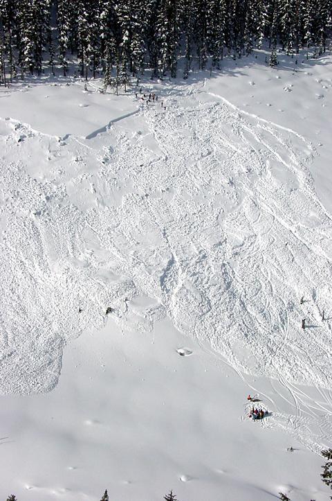
2 Why do we need guidelines? Costs: 14 fatalities/year, $0.5 M/year property damage, $10 M/year avalanche control, $2 M/year static defenses (Jamieson & Stethem, 2002; McClung & Schaerer, 1993). Mapping practice & policy mostly developed in response to accidents a proactive approach is preferred Mapping practices varied depending on the industry or region affected by accidents; consultants often defined mapping standards and acceptable risk Standards/guidelines should result in more uniform practices and thus reduce loss of life & property from avalanches Risk based methods allow comparison and combination with other hazards Photo: Kevin Fogolin
3 Canada: 702 fatalities since 1782 BC: 61% AB: 13% QB: 11% NFD: 10% Terr: 5% Every railway in BC is threatened; 1370 paths threaten highways in BC; Fatalities:>90% self-triggered in backcountry travel Not recognized as a natural hazard by the Govt. of Canada; Highest fatalities of any natural hazard in Canada

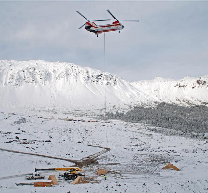
4 April, 2008: Alaska: Transmission line: $35M Photo: Scott Willis

5 Land Managers Guide to Snow Avalanche Hazards in Canada Recognition of potential avalanche problems Methods used for avalanche hazard mapping Elements of a hazard / risk map and report Selecting avalanche expertise Typical mitigation and mapping for land uses Avalanche protection
 Typical methods used for risk")
6 Guidelines for Snow Avalanche Risk Determination and Mapping in Canada Limitations of mapping Types of snow avalanche mapping Definition of risk and avalanche terms Risk guidelines for various applications (risk matrices) Typical methods used for risk determination


7 Recognition of potential avalanche problems Photo: BC Ministry of transportation Photo: Bruce Jamieson Photo: BC Ministry of Forests The obvious avalanche problem Can this area produce destructive avalanches?
 Consequences expressed in terms of: 1)")

8 Risk determination for avalanches Avalanche risk in guidelines is defined in terms of: Photo: Alan Jones Frequency (or return period) Consequences expressed in terms of: 1) Destructive potential (Canadian 5-class scale); and/or 2) Predicted impact pressures Probable exposure is also required in some applications such as transportation routes Photo: Alan Jones
9
10 The 5 part destructive Canadian size system has been adopted in: 1. USA 2. New Zealand 3. Iceland 4. Recently by the forecasting community in Europe (Volume instead of mass) Any technician or forecaster with a small amount of training can register the avalanche size

11 Size 1: avalanche..sluff

12 Size 2: Slab avalanche released by snow loading: natural
13 Size 2
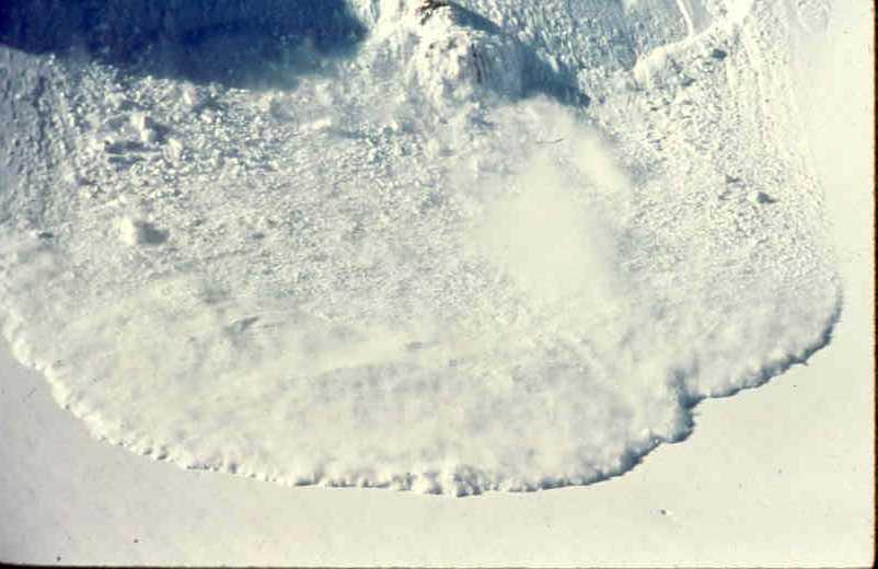
14 Size 3 avalanche: Whistler Bowl, B.C.


15 Four main types of avalanche maps Locator map Avalanche atlas Zone map From CAA, 2002 From Schaerer, 1989 Linear risk / hazard map


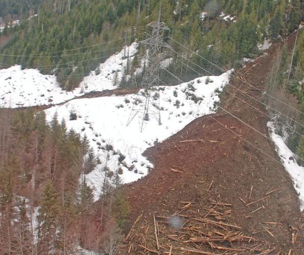
16 Applications addressed by the guidelines Transportation routes Occupied structures Forest harvest areas Photo: Tim Jensen Utility or energy corridors/structures Photos: Alan Jones Work sites Recreation operations
17 Example applications of guidelines

18 Photo: Alan Jones Transportation Routes Mica Dam Access Road, Monashee Range
19 Transportation Routes

20 Avalanche risk zones for occupied structures Kicking Horse Mountain Resort, Purcell Range Photo: KHMR/Steve Parsons

21 Avalanche risk zones for occupied structures Critical values of 30 years, 300 years and 30 kpa, and colour scheme are similar to those used in Switzerland New construction of permanently occupied structures only in White zone, some temporarily occupied structures may be permitted in Blue zone

22 Avalanche risk zones for occupied structures Kicking Horse Mountain Resort, Purcell Range Red Zone Blue Zone White Zone
23 Forest Harvesting Table VI: Risk ratings for expected avalanche size and expected avalanche frequency for forest harvest resulting in damage to forest cover Risk is rated qualitatively as low (L), moderate (M) and high (H) Frequency range (events/a) Average frequency (events/a) Qualitative risk for avalanche size 2 3 >3 >1 1:3 1:1 M H H 1:3 1:30 1:10 L M H 1:30 1:300 1:100 L L H Table VII: Risk ratings for expected avalanche size and frequency for forest harvest when down-slope transportation corridors, facilities or essential resources may be affected. Risk is rated qualitatively as: low (L), moderate (M) and high (H). Frequency range (events/a) Average frequency (events/a) Qualitative risk for avalanche size 2 3 >3 >1 1:10 1:3 M H H 1:10 1:100 1:30 L M H <1:100 1:300 L L H


24 Forest Harvesting Nagle Creek, BC Coquihalla Highway Photo: Alan Jones NOT ACCEPTABLE ACCEPTABLE? Photo: Jim Bay (From CAA, 2002)
25 Frequency / Return Period: 1.Records of avalanche occurrences 2. Vegetative damage to forest 3. Estimate far into the runout zone using extreme value statistics and known return period for high frequency of events (McClung, 2000, 2005) x*: dis tan ce T T x X b exp( */ ) 0 0 b..scale parameter of extreme value fit T : Return period X : length
26 x X >45 paths..fit to Gumbel distribution 6 b
27 Runout Ratio: x/ X b: scale parameter: slope of the line
28 Notes on avalanche dynamics: 1.Cannot be used to determine runout..use statistical methods and probability or records 2. Classical Voellmy boundary conditions: not correct: avalanches don t behave with both turbulent and terms

29 Example: Explosive control

30 Size 3 avalanche: Whistler Bowl, B.C.
31
32
33 Conclusion: Initial avalanche motion is a transition in states: 1. Sliding block 2. Fluidization into a dense core with high volume fraction of solids 3. Therefore, use scaling methods and start dynamics calculations at maximum speed in the middle of the path
34 N Ratio pdf 1% 5% 10% K-S A-D C-S 29 s l-l (0.19) 0.17(1.37) 0.42(3.21) U / S m 106 beta (0.10) 0.42(1.37) 2.31(8.55) / S Um 29 s l-l (0.19) 0.22(1.37) 0.24(4.64) Um 118 beta (0.10) 0.25(1.37) 2.33(8.55) / H Um / H s l-l: shifted log-logistic distribution beta: beta distribution

35 Maximum Speed (m/s) New approach- calibrate model with data on measured maximum speed Vertical Fall (m 1/2 )
36 Land-use Planning Context Definition Speed calculation of zones depends from on destructive dynamics potential model (impact pressure) as a function of speed speed Empirical determination of frontal stopping position for the design event


37 Example: Aulta avalanche path in Switzerland Calculated speed Slope angle 25 degrees Measured speed
38 Blue zone..does it exist? From dynamics: deceleration is about 2 4 m/ s Blue zone pressures are < 30 kpa Assume speed 20m/s and density kg / m Total time to stop is 5 seconds which gives Blue Zone width of 50 m for constant friction 0.4 g cos
39 More realistic assumption is that friction increases as the avalanche slows If the speed has exponential decay with time with average deceleration 2 as 4 m/ s t V 20e cos t The time taken is still 5 seconds but the Blue Zone width is about 15m.
40 Conclusion : Blue Zone width is smaller than the uncertainty in dynamics calculations and avalanche dynamics will disappear from zoning applications. When friction is shared by: 2,kv terms (Voellmy assumption): friction drops as speed slows to allow wider Blue Zone but avalanches don t behave this way.
41 Conclusions For most applications, expected size and frequency are combined to assess acceptable risk For Occupied Structures, it is expected that dynamics will disappear from zoning schemes to be replaced by empirical runout methods Canada is a leader in risk-based planning for avalanche applications
VISITOR RISK MANAGEMENT APPLIED TO AVALANCHES IN NEW ZEALAND
 VISITOR RISK MANAGEMENT APPLIED TO AVALANCHES IN NEW ZEALAND Don Bogie*, Department of Conservation, Christchurch, New Zealand Mike Davies, Department of Conservation, Wellington, New Zealand ABSTRACT:
A TECHNICAL MANUAL FOR ASSESSING, MAPPING AND MITIGATING SNOW AVALANCHE RISK
 A TECHNICAL MANUAL FOR ASSESSING, MAPPING AND MITIGATING SNOW AVALANCHE RISK Bruce Jamieson 1*, Ryan Buhler 2, Cam Campbell 3, Michael Conlan 4, Brian Gould 3, Greg Johnson 5, Alan Jones 2, Grant Statham
DESIGN-MAGNITUDE AVALANCHE MAPPING AND MITIGATION ANALYSIS KIRKWOOD RESORT, CALIFORNIA -- AN UPDATED STUDY. Prepared For. Mr.
 0 ----- )11.eCtfS t QQ'7 0 f-ieceivel) P,mador County MAR 0 3 2003 PLANNING DEPARTMENT DESIGN-MAGNITUDE AVALANCHE MAPPING AND MITIGATION ANALYSIS KIRKWOOD RESORT, CALIFORNIA -- AN UPDATED STUDY Prepared
THRESHOLD GUIDELINES FOR AVALANCHE SAFETY MEASURES
 BRITISH COLUMBIA MINISTRY OF TRANSPORTATION & INFRASTRUCTURE AVALANCHE & WEATHER PROGRAMS THRESHOLD GUIDELINES FOR AVALANCHE SAFETY MEASURES British Columbia Ministry of Transportation & Infrastructure
ENVIRONMENTAL HAZARDS OF AVALANCHES: PRELIMINARY RESEARCH IN GLACIER NATIONAL PARK
 ENVIRONMENTAL HAZARDS OF AVALANCHES: PRELIMINARY RESEARCH IN GLACIER NATIONAL PARK Site Focus: Balu Pass, Glacier National Park, B.C. Avalanche path near Balu Pass. (Photo Courtesy of: www.leelau.net/2007/rogerspass/day1/1)
International Snow Science Workshop
 A PRACTICAL USE OF HISTORIC DATA TO MITIGATE WORKER EXPOSURE TO AVALANCHE HAZARD Jake Elkins Jackson Hole Mountain Resort, Teton Village, Wyoming Bob Comey* Jackson Hole Mountain Resort, Teton Village,
Structural Avalanche Defenses Chris Wilbur, P.E. Wilbur Engineering, Inc. SW Colorado Chapter ASCE February 15, 2012
 Structural Avalanche Defenses Chris Wilbur, P.E. Wilbur Engineering, Inc. SW Colorado Chapter ASCE February 15, 2012 Outline Design Avalanche Types of Structures Deflecting/Diversion Dams & Retarders Snowsheds
Avalanche Protection. Safety without Compromise
 Avalanche Protection Safety without Compromise Photo: Adobe Stock jancsi hadik Photo: Adobe Stock wakr10 Trumer Schutzbauten designs, produces and sells solutions for protection against natural hazards
RE: Extreme Avalanche Hazard at New Jumbo Glacier Resort (JGR) Daylodge Building Site
 Daylodge Building Site") To: Ms. Autumn Cousins Manager, Policy and Compliance BC Environmental Assessment Office, via Email to autumn.cousins@gov.bc.ca and eao.compliance@gov.bc.ca PO Box 9426 Stn Prov Govt Victoria, BC V8W 9V1
To: Ms. Autumn Cousins Manager, Policy and Compliance BC Environmental Assessment Office, via Email to autumn.cousins@gov.bc.ca and eao.compliance@gov.bc.ca PO Box 9426 Stn Prov Govt Victoria, BC V8W 9V1
Ski / Sled tracks as an expression of avalanche risk Jordy Hendrikx 1 & Jerry Johnson 2,1 1.
 Ski / Sled tracks as an expression of avalanche risk Jordy Hendrikx 1 & Jerry Johnson 2,1 1 Snow and Avalanche Laboratory, Montana State University, Bozeman, Montana, USA 2 Political Science, Montana State
Proceedings, 2012 International Snow Science Workshop, Anchorage, Alaska
 I-90 SNOQUALMIE PASS: OPERATING A HIGHWAY AVALANCHE PROGRAM DURING A MAJOR CONSTRUCTION PROJECT John Stimberis, Washington State Department of Transportation ABSTRACT: Snoqualmie Pass, WA (921m) receives
Jumbo Glacier Resort Master Plan Appendix 2-A
 Jumbo Glacier Resort Master Plan Appendix 2-A Avalanche Studies and Reports prepared by P. Schaerer of Stetham & Associates Pheidias Project Management Corp. Copyright June, 2005 JUMBO
Proceedings, International Snow Science Workshop, Innsbruck, Austria, 2018
 AN OPERATIONAL SPECIFIC AVALANCHE RISK MATRIX (OSARM): COMBINING THE CONCEPTUAL MODEL OF AVALANCHE HAZARD WITH RISK ANALYSIS AND OPERATIONAL MITIGATION STRATEGIES Langeland S. 1 *, Velsand P. 1, Solemsli
Simple calculations of avalanche risk for backcountry skiing
 International Sw Science Workshop, Davos 2009, Proceedings Simple calculations of avalanche risk for backcountry skiing Bruce Jamieson 1,2, Jürg Schweizer 3, Cora Shea 2 1 Dept. of Civil Engineering, University
2010 International Snow Science Workshop
 MAPPING EXPOSURE TO AVALANCHE TERRAIN Cam Campbell* and Peter Marshall Canadian Avalanche Centre, Revelstoke, British Columbia ABSTRACT: During the winter of 2009-10, several signs were created in collaboration
e. Artificial avalanche release. This usually consists of delivering explosives to avalanche starting 2.5 AVALANCHE MITIGATION
 2.5 AVALANCHE MTGATON 2.5.1 General considerations Several alternative forms of avalanche mitigation are in use around the world. The selection of the best form of avalanche protection in a given area
SNOW AVALANCHE AVOIDANCE POLICY 2011
 SNOW AVALANCHE AVOIDANCE POLICY 2011 BC Public Service Natural Resource Sector For General Wilderness Activities Acknowledgements: Kevin Fogolin R.P.F./Qualified Avalanche Planner (Island Alpine Consulting
Avalanche risk assessment 3
 Avalanche risk assessment 3 3.1 PROTECTION FORESTS In Europe, where extensive forest clearance occurred in past centuries, mid- and upper-slope forest areas are designated as having a protection role wherever
Bird Strike Damage Rates for Selected Commercial Jet Aircraft Todd Curtis, The AirSafe.com Foundation
 Bird Strike Rates for Selected Commercial Jet Aircraft http://www.airsafe.org/birds/birdstrikerates.pdf Bird Strike Damage Rates for Selected Commercial Jet Aircraft Todd Curtis, The AirSafe.com Foundation
Avalanche Observations
 Avalanche Observations Avalanche Observations 3.1 Introduction Observations of past and present avalanche activity are of the utmost importance for any avalanche forecasting operation. These data should
Proceedings, International Snow Science Workshop, Banff, 2014
 AVALANCHE ACCIDENTS INVOLVING PEOPLE ALONG TRANSPORTATION CORRIDORS AND THE IMPLICATIONS FOR AVALANCHE OPERATIONS Timothy D. Glassett 1*, Frank Techel 2 1 Alaska Department of Transportation, Girdwood,
Part 1: Introduction to Decision Making
 Part 1: Introduction to Decision Making 1.1 - Anatomy of a Decision ABOUT AIARE Learning Outcomes Identify that backcountry decision making involves five key components: Plan, Observe, Teamwork, Choose
Risk Assessment in Winter Backcountry Travel
 Wilderness and Environmental Medicine, 20, 269 274 (2009) ORIGINAL RESEARCH Risk Assessment in Winter Backcountry Travel Natalie A. Silverton, MD; Scott E. McIntosh, MD; Han S. Kim, PhD, MSPH From the
Report Tómas Jóhannesson Þorsteinn Arnalds Leah Tracy. Results of the 2D avalanche model SAMOS for Ísafjörður and Hnífsdalur
 Report 02018 Tómas Jóhannesson Þorsteinn Arnalds Leah Tracy Results of the 2D avalanche model SAMOS for Ísafjörður and Hnífsdalur VÍ-ÚR13 Reykjavík June 2002 -3- BACKGROUND The 2D avalanche model SAMOS,
Proceedings, International Snow Science Workshop, Breckenridge, Colorado, 2016
 THE WHITE PASS AND YUKON ROUTE AVALANCHE PROGRAM, FORECASTING AND RISK MAN- AGEMENT FOR A HISTORICAL RAILROAD Bill Glude Alaska Avalanche Specialists, Juneau, AK The White Pass and Yukon Route (WPYR) is
a. The historic avalanche areas, or areas in which there exists clear evidence of previous avalanches, are mapped.
 1 OBJECTIVES AND LIMITATIONS OF STUDY ;J'-o~ 1 j 1.1 BACKGROUND AND STUDY OBJECTIVES The communities of Aspendell, Habegger's, and Sage Flat are located in the eastern Sierra Nevada west of the towns of
Slot Couloir Accident, Snoqualmie Mt
 Body Page 1 Slot Couloir Accident, Snoqualmie Mt 4-27-14 Date and Time: estimated 12 pm, Sunday 4/27/14 Location: Slot Couloir, Snoqualmie Mt Number in Party: 2 backcountry skiers Number hurt: 1 backcountry
American Avalanche Association Forest Service National Avalanche Center Avalanche Incident Report: Long Form
 American Avalanche Association Forest Service National Avalanche Center Avalanche Incident Report: Long Form Please send to: CAIC; 325 Broadway WS1; Boulder CO 80305; caic@qwest.net; Fax (303) 499-9618
Worst-case analysis of wake vortex induced risk of 700ft vertical separation. Gerben van Baren
 Worst-case analysis of wake vortex induced risk of 700ft vertical separation Gerben van Baren Contents Incentive Objective Approach Results Conclusions NLR Air Transport Safety Institute 15-1-2009 2 Incentive
VOLUME CHANGES OF THE GLACIERS IN SCANDINAVIA AND ICELAND IN THE 21st CENTURY
 VOLUME CHANGES OF THE GLACIERS IN SCANDINAVIA AND ICELAND IN THE 21st CENTURY Valentina Radić 1,3 and Regine Hock 2,3 1 Depart. of Earth & Ocean Sciences, University of British Columbia, Vancouver, Canada
Avalanche Hazard Investigations, Zoning, and Ordinances, Utah, Part 2
 Avalanche Hazard Investigations, Zoning, and Ordinances, Utah, Part 2 David A. Scroggin, Jack Johnson Company L. Darlene Batatian, P.G., Mountain Land Development ABSTRACT: The Wasatch Mountains of Utah
Opportunities for Snowmobile Avalanche Education: An Exploration of the Current State of Snowmobiling in the Backcountry
 Opportunities for Snowmobile Avalanche Education: An Exploration of the Current State of Snowmobiling in the Backcountry Proposal of Final Project by Miranda Murphy Master of Arts - Integrated Studies
Jumbo Glacier Resort Master Plan. Appendix 3-K
 Jumbo Glacier Resort Master Plan Appendix 3-K Letter re: Review of M. Austin s Analysis Report: Potential Impacts of the Proposed JGR on the Central Purcell Grizzly Bear Population Prepared by ENKON Environmental
QUANTIFYING THE OBVIOUS: THE AVALANCHE DANGER LEVEL
 QUANTIFYING THE OBVIOUS: THE AVALANCHE DANGER LEVEL Jürg Schweizer 1, *, Christoph Mitterer 2, Frank Techel 1, Andreas Stoffel 1, Benjamin Reuter 3 1 WSL Institute for Snow and Avalanche Research SLF,
FRANCE : HOW TO IMPROVE THE AVALANCHE KNOWLEDGE OF MOUNTAIN GUIDES? THE ANSWER OF THE FRENCH MOUNTAIN GUIDES ASSOCIATION. Alain Duclos 1 TRANSMONTAGNE
 FRANCE : HOW TO IMPROVE THE AVALANCHE KNOWLEDGE OF MOUNTAIN GUIDES? THE ANSWER OF THE FRENCH MOUNTAIN GUIDES ASSOCIATION ABSTRACT : Alain Duclos 1 TRANSMONTAGNE Claude Rey 2 SNGM The French Mountain Guides
J. Oerlemans - SIMPLE GLACIER MODELS
 J. Oerlemans - SIMPE GACIER MODES Figure 1. The slope of a glacier determines to a large extent its sensitivity to climate change. 1. A slab of ice on a sloping bed The really simple glacier has a uniform
Twin Lakes Avalanche Incident 1/31/2016
 Twin Lakes Avalanche Incident 1/31/2016 Location: Place State Published by: Dave Bingaman (PAC), George Halcom (PAC), and Kent May (PAC) Twin Lakes, Salmon River Mountains Idaho Date 01/31/2016 Time Summary
ABSTRACT. Copyright Environment Canada, Canadian Parks Service, 1989
 KEL^LZ3 ABSTRACT The Rogers Pass avalanche defence operation protects a 40 km segment of highway and railway corridor centered on Rogers Pass. Glacier National Park, British Columbia. Canada. One hundred
Prior to contacting the Whitecourt Trailblazers Snowmobile Club, applicants must:
 WHITECOURT TRAILBLAZERS Box 607 Whitecourt, AB T7S 1N7 www.whitecourttrailblazers.ca CNT AMENDMENT Restriction Code 710: See Comments Comments All applicants are required to contact: Whitecourt Trailblazers
How many accidents is a collision? Hans de Jong Eurocontrol Safety R&D Seminar, Southampton,
 How many accidents is a collision? Hans de Jong Eurocontrol Safety R&D Seminar, Southampton, 24.10.2008 Introduction Interesting about moving is to experience people have different views Even more interesting
Proceedings, International Snow Science Workshop, Banff, 2014
 QUANTITATIVE RISK ASSESSMENT FOR THE SNOQUALMIE PASS AVALANCHE BRIDGES Alan Jones, P.Eng. 1 *, Greg Johnson, P.Eng. 2 and Kevin Dusenberry, S.E. 3 1 Dynamic Avalanche Consulting Ltd., Revelstoke, BC, Canada
LEVEL 1 - AVALANCHE OVERVIEW HANDOUT
 Bill Glude Alaska Avalanche Specialists 20111202 All photos and graphics Bill Glude unless otherwise noted. LEVEL 1 - AVALANCHE OVERVIEW HANDOUT Summary of Key Points Statistics 1 2 3 Urban Avalanches
THE YIELD OF AVALANCHE SNOW AT ROGERS PASS, BRITISH COLUMBIA, CANADA
 Journal / Glaciology, Vol. 34, No. 117, 1988 THE YIELD OF AVALANCHE SNOW AT ROGERS PASS, BRITISH COLUMBIA, CANADA By PETER SCHAERER (Institute for Research in Construction, National Research Council of
Assessment of the ice throw and ice fall risks nearby wind energy installations
 Assessment of the ice throw and ice fall risks nearby wind energy installations Michaela Kaposvari, Thorsten Weidl TÜV SÜD Industrie Service GmbH, Winterwind, February 4 th, 2015 Folie 2 Initial Situation
Proceedings, International Snow Science Workshop, Banff, 2014
 TRAVEL ADVICE FOR THE AVALANCHE PROBLEMS: A PUBLIC FORECASTING TOOL Wendy Wagner 1 * and Drew Hardesty 2 1 Chugach National Forest Avalanche Center, Girdwood, Alaska 2 Utah Avalanche Center, Salt Lake
OCCURRENCE CONDITIONS OFTWO CATASTROPHIC AVALANCHES AT CHAMONIX, FRANCE. Franyois RAPIN and Christophe ANCEy l Cemagref, France
 OCCURRENCE CONDITIONS OFTWO CATASTROPHIC AVALANCHES AT CHAMONIX, FRANCE Franyois RAPIN and Christophe ANCEy l Cemagref, France ABSTRACT: In February 1999, in Chamonix, France, a large avalanche destroyed
7:00 p.m. General meeting called to order. Paul Conte, Chair 7:05 p.m. Introductions Reminder: All JWN members should fill out and return a sign-in
 Agenda 7:00 p.m. General meeting called to order. Paul Conte, Chair 7:05 p.m. Introductions Reminder: All JWN members should fill out and return a sign-in card to receive a ballot. All guests are requested
SNOW AVALANCHES IN PROVO CANYON, UTAH
 SNOW AVALANCHES IN PROVO CANYON, UTAH KEVIN GRIFFITH REGION THREE AVALANCHE FORECASTER UTAH DEPARTMENT OF TRANSPORTATION 825 NORTH 900 WEST OREM, UTAH 84057-3958 USA (801 )-227-8000 TEL (801 )-227-8049
Using stability tests and regional avalanche danger to estimate the local avalanche danger
 176 Annals of Glaciology 51(54) 2010 Using stability tests and regional avalanche danger to estimate the local avalanche danger Laura BAKERMANS, 1,2 Bruce JAMIESON, 1,3 Jürg SCHWEIZER, 4 Pascal HAEGELI
MP : the top of the bottom switchback
 MP 237 238: the top of the bottom switchback For reference this section of U S Highway 40 has been called the top of the bottom switchback on the Grand County side of the Pass. It is here that the proposed
A technical manual for assessing, mapping and mitigating snow avalanche risk
 A technical manual for assessing, mapping and mitigating snow avalanche risk Bruce Jamieson Snowline Associates Ltd., Calgary, Alberta, Canada Alan Jones Dynamic Avalanche Consulting Ltd., Revelstoke,
Aircraft Noise. Why Aircraft Noise Calculations? Aircraft Noise. SoundPLAN s Aircraft Noise Module
 Aircraft Noise Why Aircraft Noise Calculations? Aircraft Noise Aircraft noise can be measured and simulated with specialized software like SoundPLAN. Noise monitoring and measurement can only measure the
Tidewater Glaciers: McCarthy 2018 Notes
 Tidewater Glaciers: McCarthy 2018 Notes Martin Truffer, University of Alaska Fairbanks June 1, 2018 What makes water terminating glaciers special? In a normal glacier surface mass balance is always close
AVALANCHE RISK EVALUTION WITH PRACTICAL SUGGESTIONS FOR RISK MINIMISATION: A CASE STUDY OF THE MILFORD ROAD, NEW ZEALAND
 AVALANCHE RISK EVALUTION WITH PRACTICAL SUGGESTIONS FOR RISK MINIMISATION: A CASE STUDY OF THE MILFORD ROAD, NEW ZEALAND Jordy Hendrikx a* Ian Owens b, Wayne Carran c, Ann Carran c a National Institute
March 2016 Safety Meeting
 March 2016 Safety Meeting AC 61 98C Subject: Currency Requirements and Guidance for the Flight Review and Instrument Proficiency Check Date: 11/20/15 AC No: 61-98C Initiated by: AFS-800 Supercedes: AC
AVALANCHE TERRAIN. Bill Glude Alaska Avalanche Specialists All photos and graphics Bill Glude unless otherwise noted.
 Bill Glude Alaska Avalanche Specialists 20111202 All photos and graphics Bill Glude unless otherwise noted. AVALANCHE TERRAIN The Key Questions 1.) Could the terrain produce an avalanche?! a.) Where you
Appendix B CLEAR ZONES AND ACCIDENT POTENTIAL ZONES
 Appendix B CLEAR ZONES AND ACCIDENT POTENTIAL ZONES 2007 AICUZ Study B-1 THIS PAGE INTENTIONALLY LEFT BLANK B-2 2007 AICUZ Study CLEAR ZONES AND ACCIDENT POTENTIAL ZONES B.1 Guidelines For Accident Potential
FOREST SERVICE AVALANCHE CENTER SAFETY: EXAMINING CURRENT PRACTICE. USDA Forest Service National Avalanche Center, Bozeman, MT, USA 2
 FOREST SERVICE AVALANCHE CENTER SAFETY: EXAMINING CURRENT PRACTICE Simon A. Trautman 1 *, Scott D. Savage 2 and Karl W. Birkeland 1 1 USDA Forest Service National Avalanche Center, Bozeman, MT, USA 2 Sawtooth
Glaciology. Water. Glacier. Moraine. Types of glacier-dammed lakes. Mechanics of jökulhlaup
 A Jökulhlaup Jökulhlaup. Catastrophic events where large amounts of water are suddenly discharged. Jökulhlaup s are a sudden and rapid draining of a glacier dammed lake or of water impounded within a glacier.
Challenges in the Airspace Safety Monitoring
 Challenges in the Airspace Safety Monitoring Antar Bandyopadhyay (Based on joint project with BOBASMA, AAI & ISI) Theoretical Statistics and Mathematics Unit Indian Statistical Institute, New Delhi and
PERFORMANCE MEASURE INFORMATION SHEET #16
 PERFORMANCE MEASURE INFORMATION SHEET #16 ARROW LAKES RESERVOIR: RECREATION Objective / Location Recreation/Arrow Lakes Reservoir Performance Measure Access Days Units Description MSIC 1) # Access Days
Study on impact force calculation formula. of ship lock gravity dolphin
 5th International Conference on Civil Engineering and Transportation (ICCET 2015) Study on impact force calculation formula of ship lock gravity dolphin Guilan Taoa, Jian Ruanb, Yingying Panc, Yajun Yand
SLOPE CALCULATION. Wilderness Trekking School 1
 SLOPE CALCULATION By Joe Griffith, February 2014 Objectives Upon completion of this chapter, you will be able to: Read the rise-over-run from a topographic map. Convert the rise-over-run into a slope angle
BLASTING GLACIAL ICE AND SNOW ABSTRACT
 BLASTING GLACIAL ICE AND SNOW HERB BLEUER ABSTRACT This presentation, with the aid of slides, is about methods of blasting large quantities of glacial ice and snow. The project illustrated here involved
International Snow Science Workshop
 GUIDELINES FOR AVALANCHE CONTROL SERVICES: ORGANIZATION, HAZARD ASSESSMENT AND DOCUMENTATION AN EXAMPLE FROM SWITZERLAND Lukas Stoffel* and Jürg Schweizer WSL Institute for Snow and Avalanche Research
2010 International Snow Science Workshop
 A GIS DATABASE FOR AVALANCHE FORECASTING IN COLORADO Douglas Scott 1* and Ethan Greene 2 1 Avalanche Mapping, Lafayette, Colorado, U.S.A. 2 Colorado Avalanche Information Center, Boulder, Colorado, U.S.A.
AVALANCHE FLOTATION DEVICES
 AVALANCHE FLOTATION DEVICES 1. ISSUE In the Coroner s Report into the deaths of Ms. Kimberly Anne Manchip and Mr. Daisuke Matsui, both of whom were caught in an avalanche and died from asphyxiation, the
Snowmobile GUIDELINES FOR TRAIL SIGNING
 STATE OF NEW HAMPSHIRE BUREAU OF TRAILS Snowmobile GUIDELINES FOR TRAIL SIGNING TRAIL FUNDED BY REGISTRATION FEES Table of Contents Introduction... Some Things to Take Into Consideration... BOT Provided
Safety Analysis of the Winch Launch
 Safety Analysis of the Winch Launch Trevor Hills British Gliding Association and Lasham Gliding Society ts.hills@talk21.com Presented at the XXVIII OSTIV Congress, Eskilstuna, Sweden, 8-15 June 26 Abstract
Avalanche Forecasting for Transportation Corridor and Backcountry in Glacier National Park (BC, Canada)
") Avalanche Forecasting for Transportation Corridor and Backcountry in Glacier National Park (BC, Canada) Jürg Schweizer and J. Bruce Jamieson Department of Civil Engineering, University of Calgary, 5 University
Avalanche Forecasting for Transportation Corridor and Backcountry in Glacier National Park (BC, Canada) Jürg Schweizer and J. Bruce Jamieson Department of Civil Engineering, University of Calgary, 5 University
Typical avalanche problems
 Typical avalanche problems The European Avalanche Warning Services (EAWS) describes five typical avalanche problems or situations as they occur in avalanche terrain. The Utah Avalanche Center (UAC) has
River debris: Characteristics, Impacts, and Potential Mitigation Methods
 River debris: Characteristics, Impacts, and Potential Mitigation Methods J. B. Johnson 1, R. Tyler 2, J. Schmid 1 1 University of Alaska Fairbanks 2 Ocean Renewable Power Company 4/29/2013 ACEP Rural Energy
Proceedings, 2012 International Snow Science Workshop, Anchorage, Alaska
 ZONING WITH THE AVALANCHE TERRAIN EXPOSURE SCALE Cam Campbell 1,2, *, Brian Gould 2, and James Newby 2,3 1 Canadian Avalanche Centre, Revelstoke, British Columbia 2 Alpine Solutions Avalanche Services,
Simulation of disturbances and modelling of expected train passenger delays
 Computers in Railways X 521 Simulation of disturbances and modelling of expected train passenger delays A. Landex & O. A. Nielsen Centre for Traffic and Transport, Technical University of Denmark, Denmark
Physics Is Fun. At Waldameer Park! Erie, PA
 Physics Is Fun At Waldameer Park! Erie, PA THINGS TO BRING: Amusement Park Physics Bring a pencil Bring a calculator Don t forget to bring this assignment packet Bring a stop watch, a digital watch, or
Avalanche Safety Basics By Sandy K. Ott
 Avalanche Safety Basics By Sandy K. Ott For Mountain Riders, or Those Going Into the Mountains to Ride There is one common theme when the avalanche experts go investigate avy incidents. The responses they
Lake Manyara Elephant Research
 Elephant Volume 1 Issue 4 Article 16 12-15-1980 Lake Manyara Elephant Research Rick Weyerhaeuser World Wildlife Fund - U.S. Follow this and additional works at: https://digitalcommons.wayne.edu/elephant
THE AVALANCHE VICTIM. K. Williams
 - 232 - THE AVALANCHE VICTIM K. Williams Introduction "The victim is a male, 27 years old, has had several years of skiing or mountaineering experience, and didn't know an avalanche from a snowball." Thus
CONGESTION MONITORING THE NEW ZEALAND EXPERIENCE. By Mike Curran, Manager Strategic Policy, Transit New Zealand
 CONGESTION MONITORING THE NEW ZEALAND EXPERIENCE 26 th Australasian Transport Research Forum Wellington New Zealand 1-3 October 2003 By, Manager Strategic Policy, Transit New Zealand Abstract New Zealand
AVALANCHE SAFETY PLAN
 AVALANCHE SAFETY PLAN MUNICIPALITY OF VALTOURNENCHE Valtournenche is a town located at the foot of the Mount Cervin, whose beauty attracts a large number of tourists. The morphology of the territory, characterized
Restore and implement protected status that is equivalent, or better than what was lost during the mid-1990 s
 THE ROSSLAND RANGE, OLD GLORY AREA. Executive summary. The Friends of the Rossland Range Society, on behalf of the local outdoor community, seeks to accomplish the following with respect to the Old Glory
Railway-Highway Crossing at Grade Regulations: Guidelines for British Columbia s Provincial Heritage Railways
 Railway-Highway Crossing at Grade Regulations: Guidelines for British Columbia s Provincial Heritage Railways SHORT TITLE 1. These Guidelines may be cited as the Railway-Highway Crossing at Grade Guidelines.
Airspace Complexity Measurement: An Air Traffic Control Simulation Analysis
 Airspace Complexity Measurement: An Air Traffic Control Simulation Analysis Parimal Kopardekar NASA Ames Research Center Albert Schwartz, Sherri Magyarits, and Jessica Rhodes FAA William J. Hughes Technical
A conceptual model of avalanche hazard
 Nat Hazards (2018) 90:663 691 https://doi.org/10.1007/s11069-017-3070-5 ORIGINAL PAPER A conceptual model of avalanche hazard Grant Statham 1 Pascal Haegeli 2,3 Ethan Greene 5 Karl Birkeland 4 Clair Israelson
2. In terms of forces, explain why Batman The Ride uses a long shallow climb up the first incline instead of a short steep one.
 QUALITATIVE QUESTIONS Batman The Ride 1. When you enter Batman The Ride, you walk the first 7.2 meters vertically to get on. What is the advantage to Six Flags St. Louis of having you do this? 2. In terms
GEOSPATIAL ANALYSIS OF GLACIAL HAZARDS PRONE AREAS OF SHIGAR AND SHAYOK BASINS OF PAKISTAN. By Syed Naseem Abbas Gilany
 GEOSPATIAL ANALYSIS OF GLACIAL HAZARDS PRONE AREAS OF SHIGAR AND SHAYOK BASINS OF PAKISTAN By Syed Naseem Abbas Gilany PRESENTATION OUTLINE Introduction Problem Statement / Rationale Objectives Material
Traffic Forecasts. CHAOUKI MUSTAPHA, Economist, International Civil Aviation Organization
 SIP/2009-WP/11 Business case Traffic Forecasts CHAOUKI MUSTAPHA, Economist, International Civil Aviation Organization Workshop on the Development of Business Case for the Implementation of CNS/ATM Systems
2.0 PARK VISION AND ROLES
 2.0 PARK VISION AND ROLES 2.1 Significance in the Protected Area System Marble Range and Edge Hills provincial parks protect 6.8% of the Pavillion Ranges Ecosection, which is located in the Southern Interior
Avalanches and the Mount Whitney Basin
 Avalanches and the Mount Whitney Basin 10 April 2006 by Bob Rockwell Prelude Avalanches are a fact of life in high mountains in winter, and we take courses to find out about them. We learn how to assess
AIR TRANSPORT MANAGEMENT Universidade Lusofona January 2008
 AIR TRANSPORT MANAGEMENT Universidade Lusofona Introduction to airline network planning: John Strickland, Director JLS Consulting Contents 1. What kind of airlines? 2. Network Planning Data Generic / traditional
ANAGEMENT. LAN November, 1996
 M ANAGEMENT P LAN November, 1996 for Coldwater River Provincial Park Ministry of Environment, Lands and Parks BC Parks Department Coldwater River Provincial Park M ANAGEMENT P LAN Prepared by BC Parks
PHY 133 Lab 6 - Conservation of Momentum
 Stony Brook Physics Laboratory Manuals PHY 133 Lab 6 - Conservation of Momentum The purpose of this lab is to demonstrate conservation of linear momentum in one-dimensional collisions of objects, and to
THE IMPACTS OF CLIMATE CHANGE ON SKI RESORTS AND TOURIST TRAFFIC. M. Tepfenhart, W. Mauser and F. Siebel
 THE IMPACTS OF CLIMATE CHANGE ON SKI RESORTS AND TOURIST TRAFFIC M. Tepfenhart, W. Mauser and F. Siebel Department of Geography, University of Munich, Luisenstr. 37, D - 80333 Munich, Germany, Sebastian
Labrador - Island Transmission Link Target Rare Plant Survey Locations
 27-28- Figure: 36 of 55 29-28- Figure: 37 of 55 29- Figure: 38 of 55 #* Figure: 39 of 55 30- - east side Figure: 40 of 55 31- Figure: 41 of 55 31- Figure: 42 of 55 32- - secondary Figure: 43 of 55 32-
NWAC Blog. Cornices - don't walk the line! Written by Robert Hahn on March 14, Last update on May 15, 2017.
 NWAC Blog Cornices - don't walk the line! Written by Robert Hahn on March 14, 2017. Last update on May 15, 2017. Human-triggered cornice fall avalanche from March 10th, 2017. The crown release exposed
DRAFT. Airport Master Plan Update Sensitivity Analysis
 Dallas Love Field Sensitivity Analysis PREPARED FOR: The City of Dallas Department of Aviation PREPARED BY: RICONDO & ASSOCIATES, INC. August 201 Ricondo & Associates, Inc. (R&A) prepared this document
4. Serrated Trailing Edge Blade Designs and Tunnel Configuration
 Chapter 4: Serrated Trailing Edge Blade Designs 97 CHAPTER FOUR 4. Serrated Trailing Edge Blade Designs and Tunnel Configuration 4.1 Introduction To evaluate the effectiveness of trailing edge serrations
TUPPER DESIGNATED ACCESS ROUTE
 TUPPER DESIGNATED ACCESS ROUTE 1 FOR ACCESS/EGRESS TO CONNAUGHT, LOOKOUT, STONE ARCH, PORTAL PATHS AND TUPPER TRAVERSE EGRESS Length: 2.6km Vertical Gain: +162m / -83m (Values are for access. For egress,
Appendix B Ultimate Airport Capacity and Delay Simulation Modeling Analysis
 Appendix B ULTIMATE AIRPORT CAPACITY & DELAY SIMULATION MODELING ANALYSIS B TABLE OF CONTENTS EXHIBITS TABLES B.1 Introduction... 1 B.2 Simulation Modeling Assumption and Methodology... 4 B.2.1 Runway
along a transportation corridor in
 Rockfall hazard and risk assessment along a transportation corridor in the Nera Valley, Central Italy Presentation on the paper authored by F. Guzzetti and P. Reichenbach, 2004 Harikrishna Narasimhan Eidgenössische