Ground Deformation Monitoring at Natural Gas Production Sites using Interferometric SAR
|
|
|
- Damon Franklin
- 6 years ago
- Views:
Transcription
1 Ground Deformation Monitoring at Natural Gas Production Sites using Interferometric SAR By: Kanika Goel, Robert Shau, Fernando Rodriguez Gonzalez, Nico Adam Remote Sensing Technology Institute (IMF), German Aerospace Center (DLR), Germany
2 Introduction


3 Motivation Natural gas production has increased significantly to meet energy demands Extraction leads to decreased reservoir pressure and may cause subsidence Monitoring this subsidence important for geological and hazard analysis Ground deformation illustration

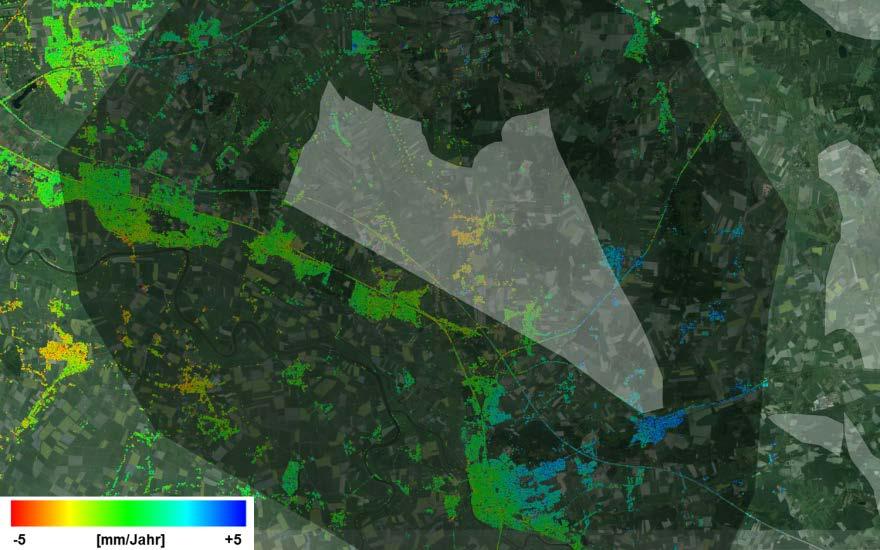
4 Natural Gas in Germany Small volumes produced as compared internationally In 2007, 17% domestic consumption from domenstic production Lower-Saxony accounted for 93% of German natural gas production BGR, Germany, collaborating with DLR for monitoring subsidence due to natural gas extraction Source: BGR, Germany
5 Interferometric SAR (InSAR) Powerful remote sensing technique for detecting ground deformation m s Deformation estimation using 2 SAR images and Digital Elevation Model (DEM) Interferogram phase contributions: Deformation

6 C-Band SAR Medium resolution of 25 m 5.6 cm wavelength 100 km swath width ERS

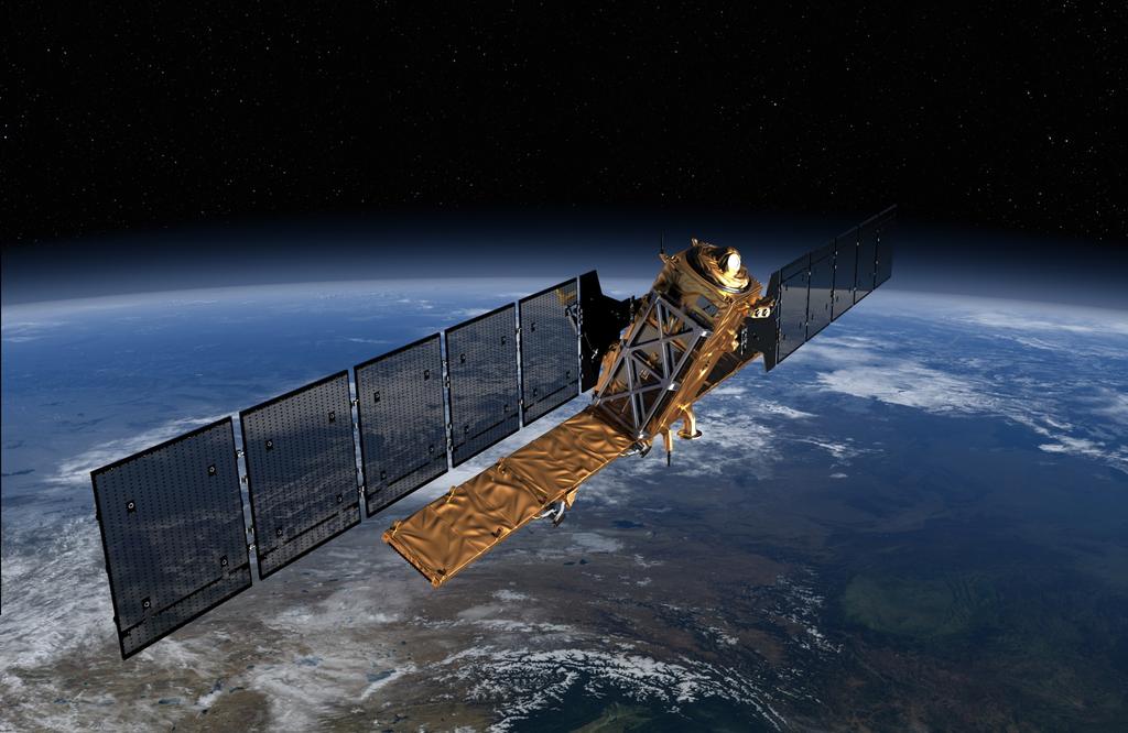
7 X-Band SAR High resolution of up to 1 m 3.1 cm wavelength High sensitivity to even millimetric displacements TerraSAR-X (TSX)
8 Methodology


9 Persistent Scatterer Interferometry (PSI) Coherent InSAR stacking technique Permanently coherent PSs exploited Differential interferograms wrt a single master image used Model-based deformation estimation PS

10 DLR s Integrated Wide Area Processor (IWAP) Highly automated, efficient and robust multi-sensor PSI-GENESIS software Successful demonstration and validation during ESA's Terrafirma project Greece Turkey Source: Rodriguez Gonzalez et al., 2013
11 PSI Algorithm PSs Detection PSs Reference Network Estimation Atmospheric Phase Screen (APS) Estimation and Removal PSs Final Network Estimation
12 PSI Algorithm PSs Detection PSs Reference Network Estimation Atmospheric Phase Screen (APS) Estimation and Removal PSs Final Network Estimation

13 PSs Reference Network Estimation- Block Processing Division of scene into overlapping blocks Blockwise creation of reference network (arcs connecting the PSs) Blockwise estimation of relative deformation and residual DEM for the arcs using LAMBDA estimator Blockwise network inversion to estimate deformation and residual DEM for the PSs using least squares Merging of independently estimated blocks via least squares adjustment Illustration of block adjustment network Developed by: Werner Liebhart
 Estimation of")


14 PSs Reference Network Estimation- Single Network Creation of reference network (arcs connecting the PSs) Estimation of relative deformation and residual DEM for the arcs using LAMBDA estimator Single network inversion to estimate deformation and residual DEM for the PSs using least squares Mitigates error propagation High computational load and memory consumption
15 PSs Reference Network Estimation- Single Network Sinlge network inversion- Strategies: Solve A x = B => A T A x = A T B A T A is symmetric positive definite square matrix Exploit sparsity of A => A T A Use QR or LU decomposition for fast inversion, instead of SVD decomposition Use a parallelizable solver Estimate deformation, residual DEM and standard deviation of estimates
16 PSs Reference Network Estimation- Single Network Example matrix A dimensions: TerraSAR-X Stripmap: Size(A) = (30000, ) ERS: Size(A) = (90000, ) Sentinel-1: Size(A) = (450000, )
17 PSs Reference Network Estimation- Single Network Example matrix A dimensions: Example matrix A T A dimensions: TerraSAR-X Stripmap: TerraSAR-X Stripmap: Size(A) = (30000, ) Size(A T A) = (30000, 30000) ERS: ERS: Size(A) = (90000, ) Size(A T A) = (90000, 90000) Sentinel-1: Sentinel-1: Size(A) = (450000, ) Size(A T A) = (450000, )
18 Application Test Case and Results

19 TSX Data- Ascending Stripmap Stack
20 Time Baseline Plot

21 Master Amplitude Image
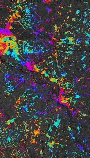
22 Interferogram Examples

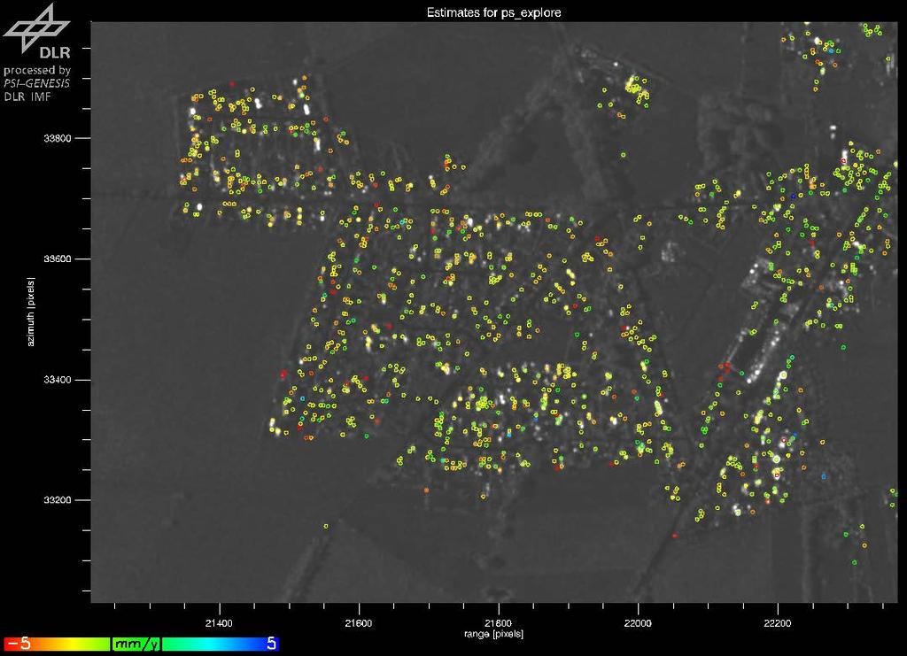
23 Deformation Estimation Results -5 [mm/jahr] +5
24 Deformation Time Series Example Area A
25 PSs Reference Network Estimation- Block Processing

26 PSs Reference Network Estimation- Block Processing


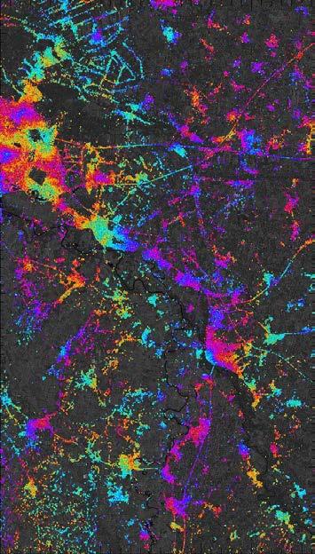
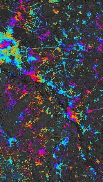
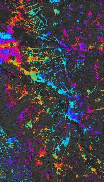
27 PSs Reference Network Estimation- Block Processing Residual topography Deformation -20 mm mm/yr +5


28 PSs Reference Network Estimation- Single Network Residual topography Deformation -20 mm mm/yr +5

29 PSs Reference Network Estimation- Difference Residual topography Deformation -20 mm mm/yr +5

 2 0.")
30 PSs Reference Network Estimation- Deformation Variance Block processing Single network 0 (mm/yr) (mm/yr) 2 0.1
31 Summary
32 Conclusion and Outlook PSI powerful and cost-effective tool for monitoring the impact of hydrocarbon reservoirs Single reference network inversion has potential to improve the deformation velocity maps Comparison with GPS data would be performed in the future to validate the pilot study Sentinel-1 data would be acquired for large area monitoring

33 Sentinel-1 Thank you Any questions?
34 PSs Reference Network Estimation- Scatter Plot -> Single Network -> Single Network -> Block processing Residual topography -> Block processing Deformation
35 PSs Reference Network Estimation- Scatter Plot -> Single Network -> Single Network -> Block processing Residual topography -> Block processing Deformation
Observations of glacier dynamics with PALSAR DATA
 Observations of glacier dynamics with PALSAR DATA Tazio Strozzi, Urs Wegmüller and Charles Werner Gamma Remote Sensing, Gümligen, Switzerland Rhodes, Greece, 3 to 7 November 2008 Outline ESA GLOBGLACIER
COSMO-Coast. L Aquila. La Sapienza. Tor Vergata. Dipartimento di Architettura ed Urbanistica. Dipartimento di Informatica, Sistemi e Produzione,
 COSMO-Coast Tor Vergata Dipartimento di Informatica, Sistemi e Produzione, L Aquila Dipartimento di Architettura ed Urbanistica La Sapienza Dipartimento Ingegneria Civile, Edile ed Ambientale Introduction
Satellite-based measurement of the surface displacement of the largest glacier in Austria
 Conference Volume 4 th Symposium of the Hohe Tauern National Park for Research in Protected Areas September 17 th to 19 th, 2009, Castle of Kaprun pages 145-149 Satellite-based measurement of the surface
SCRAMJET. Mapping and monitoring airports with Sentinel 1 and 2 data
 SCRAMJET Mapping and monitoring airports with Sentinel 1 and 2 data 18/03/2018 GISTAM 2018 Urban geospatial mapping for the SCRAMJET business networking tool Nuno Duro, Pedro Coutinho, Gil Gonçalves Index
Preliminary Results from the ATHENA-OAWL Venture Tech Airborne Mission
 Preliminary Results from the ATHENA-OAWL Venture Tech Airborne Mission Sunil Baidar (a, b), Sara Tucker (c), Mike Hardesty (a, b) (a) CIRES, University of Colorado Boulder, Boulder, CO (b) NOAA Earth System
Glacial lakes as sentinels of climate change in Central Himalaya, Nepal
 Glacial lakes as sentinels of climate change in Central Himalaya, Nepal Sudeep Thakuri 1,2,3, Franco Salerno 1,3, Claudio Smiraglia 2,3, Carlo D Agata 2,3, Gaetano Viviano 1,3, Emanuela C. Manfredi 1,3,
ERASMUS. Strategic deconfliction to benefit SESAR. Rosa Weber & Fabrice Drogoul
 ERASMUS Strategic deconfliction to benefit SESAR Rosa Weber & Fabrice Drogoul Concept presentation ERASMUS: En Route Air Traffic Soft Management Ultimate System TP in Strategic deconfliction Future 4D
Retreating Glaciers of the Himalayas: A Case Study of Gangotri Glacier Using Satellite Images
 Retreating Glaciers of the Himalayas: A Case Study of Gangotri Glacier Using 1990-2009 Satellite Images Jennifer Ding Texas Academy of Mathematics and Science (TAMS) Mentor: Dr. Pinliang Dong Department
Platform and Products
 International Partnership Space Programme Earth Observation for the Preservation of Ecological Bacalar Corridor Platform and Products Terri Freemantle, Raffaella Guida, Paula Marti, Pasquale Iervolino
Potential of CO 2 retrieval from IASI
 Potential of CO 2 retrieval from IASI L. Chaumat, O. Lezeaux, P. Prunet, B. Tournier F.-R. Cayla (SISCLE), C. Camy-Peyret (LPMAA) and T. Phulpin (CNES) Study supported by CNES ITSC-XVI: Angra dos Reis,
Comparison Study between Vault Seismometers and a New Posthole Seismometer
 Comparison Study between Vault Seismometers and a New Posthole Seismometer Presented in Salt Lake City, Utah at the Seismological Society of America s Annual Meeting, April 2013 250 Herzberg Road, Kanata,
Using of space technologies for glacierand snow- related hazards studies
 United Nations / Germany international conference on International Cooperation Towards Low-Emission and Resilient Societies Using of space technologies for glacierand snow- related hazards studies Bonn,
Surveillance and Broadcast Services
 Surveillance and Broadcast Services Benefits Analysis Overview August 2007 Final Investment Decision Baseline January 3, 2012 Program Status: Investment Decisions September 9, 2005 initial investment decision:
Investigation on Development of Agricultural Monitoring System Using Satellite Data
 Investigation on Development of Agricultural Monitoring System Using Satellite Data Genya SAITO (1), Daisuke KUNII (1), Naoki ISHITSUKA (2) (1) Tohoku University, 1-1,Tsutsumidori Amamiya-machi Aoba-ku,
Development and Testing of an Unmanned Aircraft Safety Beacon for Aerial Application Safety
 Development and Testing of an Unmanned Aircraft Safety Beacon for Aerial Application Safety Wayne Woldt, Ph.D., P.E., and Jacob Smith Biological Systems Engineering and School of Natural Resources University
Muography on Puy de Dôme. C Cârloganu LPC Clermont Ferrand IN2P3/CNRS
 Muography on Puy de Dôme C Cârloganu LPC Clermont Ferrand IN2P/CNRS Proof of principle of muography on km sized volcanoes Puy de Dôme muography reference site Institute of Nuclear Physics of Lyon Proof
Digital twin for life predictions in civil aerospace
 Digital twin for life predictions in civil aerospace Author James Domone Senior Engineer June 2018 Digital Twin for Life Predictions in Civil Aerospace Introduction Advanced technology that blurs the lines
Flight Testing the Wake Encounter Avoidance and Advisory system: First results
 Flight Testing the Wake Encounter Avoidance and Advisory system: First results Dr. Fethi Abdelmoula, Tobias Bauer DLR Institute of Flight Systems Paris, May 15 th & 16 th, 2013 WakeNet-Europe Workshop
Evolution of Ossoue glacier, French Pyrenees: Tools and methods to generate a regional climate-proxy
 Evolution of Ossoue glacier, French Pyrenees: Tools and methods to generate a regional climate-proxy Renaud MARTI ab, Simon GASCOIN a, Thomas HOUET b, Dominique LAFFLY b, Pierre RENE c a CESBIO b GEODE,
ONE PLATFORM, MULTIPLE APPLICATIONS: SURVEYING CONSTRUCTION FORESTRY AGRICULTURE ENVIRONMENT POWER ENGINEERING BIRDIE YOUR TAILOR-MADE UAV
 UAV BIRDIE BIRDIE YOUR TAILOR-MADE UAV ONE PLATFORM, MULTIPLE APPLICATIONS: SURVEYING CONSTRUCTION FORESTRY AGRICULTURE ENVIRONMENT POWER ENGINEERING BIRDIE UAV is the complete mapping solution, made for
EA-12 Coupled Harmonic Oscillators
 Introduction EA-12 Coupled Harmonic Oscillators Owing to its very low friction, an Air Track provides an ideal vehicle for the study of Simple Harmonic Motion (SHM). A simple oscillator assembles with
Establishing a Risk-Based Separation Standard for Unmanned Aircraft Self Separation
 Establishing a Risk-Based Separation Standard for Unmanned Aircraft Self Separation Roland E. Weibel, Matthew W.M. Edwards, and Caroline S. Fernandes MIT Lincoln laboratory Surveillance Systems Group Ninth
TWELFTH WORKING PAPER. AN-Conf/12-WP/137. International ICAO. developing RNAV 1.1. efficiency. and terminal In line.
 International Civil Aviation Organization WORKING PAPER 31/10/12 English only TWELFTH AIR NAVIGATION CONFERENCE Montréal, 19 to 30 November 2012 Agenda Item 5: Efficient flight paths through trajectory-based
PROSPECCIÓN ARQUEOLÓGICA A TRAVÉS DE LIDAR Y ORTOFOTOGRAMETRIA EN EL TAJÍN, VERACRUZ
 PLAN DE MANEJO INTEGRAL DE LA ZONA DE MONUMENTOS RQUEOLOGICOS EL TAJIN PROSPECCIÓN ARQUEOLÓGICA A TRAVÉS DE LIDAR Y ORTOFOTOGRAMETRIA EN EL TAJÍN, VERACRUZ Archaeological Survey through LiDAR and Orthophotogrammetry
New measurements techniques
 2 nd Asia CryoNetWorkshop New measurements techniques Xiao Cunde (SKLCS/CAS and CAMS/CMA) Feb.5, 2016, Salekhard, Russia Outline Definition of New Some relative newly-used techniques in China -- Eddy covariance
Aircraft Arrival Sequencing: Creating order from disorder
 Aircraft Arrival Sequencing: Creating order from disorder Sponsor Dr. John Shortle Assistant Professor SEOR Dept, GMU Mentor Dr. Lance Sherry Executive Director CATSR, GMU Group members Vivek Kumar David
EO technologies for flood mapping and hydrological modelling in Namibia
 Satellite Earth Observation & Disaster Risks EO technologies for flood mapping and hydrological modelling in Namibia Guido Van Langenhove, Hydrological Services Namibia Hydrological trends in Namibia:
The Past, Present, and Future of Nortek and Glider Measurements
 The Past, Present, and Future of Nortek and Glider Measurements Peter J. Rusello Scientist Nortek Since 2005, Nortek has collaborated with leading researchers to develop specialized acoustic Doppler current
Symbology comparison of Two-dimensional Symbologies with focus on EDI messages on transport labels
 EURODATA COUNCIL Symbology comparison of Two-dimensional Symbologies with focus on EDI messages on transport labels rev. 2007-10-22 global office D-06618 Naumburg, Koesener Str. 85, phone:+49(0)3445 78116
Optimizing trajectories over the 4DWeatherCube
 Optimizing trajectories over the 4DWeatherCube Detailed Proposal - SES Awards 2016 Airbus Defence and Space : dirk.schindler@airbus.com Luciad : robin.houtmeyers@luciad.com Eumetnet : kamel.rebai@meteo.fr
A New Way to Work in the ERCOT Market
 Siemens Energy, Inc. Power Technology Issue 111 A New Way to Work in the ERCOT Market Joseph M. Smith Senior Staff Business Development Specialist joseph_smith@siemens.com In recent months The Electric
Coverage of Mangrove Ecosystem along Three Coastal Zones of Puerto Rico using IKONOS Sensor
 Coverage of Mangrove Ecosystem along Three Coastal Zones of Puerto Rico using IKONOS Sensor Jennifer Toledo Rivera Geology Department, University of Puerto Rico, Mayagüez Campus P.O. Box 9017 Mayagüez,
SHIP MANAGEMENT SURVEY. July December 2017
 SHIP MANAGEMENT SURVEY July December 2017 INTRODUCTION The Ship Management Survey is conducted by the Statistics Department of the Central Bank of Cyprus and concentrates primarily on transactions between
Fuel Burn Impacts of Taxi-out Delay and their Implications for Gate-hold Benefits
 Fuel Burn Impacts of Taxi-out Delay and their Implications for Gate-hold Benefits Megan S. Ryerson, Ph.D. Assistant Professor Department of City and Regional Planning Department of Electrical and Systems
KGP 560. Enhanced Ground Proximity Warning System for General Aviation SEAMLESS SAFETY INTEGRATION THROUGH IHAS
 KGP 560 Enhanced Ground Proximity Warning System for General Aviation SEAMLESS SAFETY INTEGRATION THROUGH IHAS KGP 560 GA-EGPWS Depicted here on the KMD 850 Multi-Function Display T HE H AZARD OF CFIT
The Use of Simulation Models for Airport Planning and ATM Analysis at the Institute of Flight Guidance. Slide 1
 The Use of Simulation Models for Airport Planning and ATM Analysis at the Institute of Flight Guidance Slide 1 Dipl.Ing. Tanja Luckova > 19.05.2009 Overview 1. Key areas and sites of DLR 2. Characteristics
EVALUATION OF DIFFERENT METHODS FOR GLACIER MAPPING USING LANDSAT TM
 EVALUATION OF DIFFERENT METHODS FOR GLACIER MAPPING USING LANDSAT TM Frank Paul Department of Geography, University of Zurich, Switzerland Winterthurer Strasse 190, 8057 Zürich E-mail: fpaul@geo.unizh.ch,
PHY 133 Lab 6 - Conservation of Momentum
 Stony Brook Physics Laboratory Manuals PHY 133 Lab 6 - Conservation of Momentum The purpose of this lab is to demonstrate conservation of linear momentum in one-dimensional collisions of objects, and to
April 16, Erik Larson
 April 16, 2018 Erik Larson Contributors: ACTA: Steve Carbon, John Herndon, Ron Lambert, Elliot Porterfield FAA: Phil Bassett, Kevin Hatton, Dan Murray, Paul Wilde Project funded by: Federal Aviation Administration
Development of New Types of Glacier Dynamics Maps
 Development of New Types of Glacier Dynamics Maps Manfred F. Buchroithner, Sebastian Walther, Klaus Habermann TU Dresden Institute for Cartography Background The Project OMEGA Measurement of Glacier Movements
The use of HICO in the Southern Benguela: Saldanha Bay case study
 The use of HICO in the Southern Benguela: Saldanha Bay case study Marié Smith 1, Stewart Bernard 2, Hayley Evers-King 1 1. Department of Oceanography, University of Cape Town, South Africa 2. Council for
DMAN-SMAN-AMAN Optimisation at Milano Linate Airport
 DMAN-SMAN-AMAN Optimisation at Milano Linate Airport Giovanni Pavese, Maurizio Bruglieri, Alberto Rolando, Roberto Careri Politecnico di Milano 7 th SESAR Innovation Days (SIDs) November 28 th 30 th 2017
UAS to GIS Utilizing a low-cost Unmanned Aerial System (UAS) for Coastal Erosion Monitoring
 for Coastal Erosion Monitoring") UAS to GIS Utilizing a low-cost Unmanned Aerial System (UAS) for Coastal Erosion Monitoring Agenda Scope of today s presentation Demonstration Objectives Wrightsville Beach Test Area Masonboro Inlet Jetties
UAS to GIS Utilizing a low-cost Unmanned Aerial System (UAS) for Coastal Erosion Monitoring Agenda Scope of today s presentation Demonstration Objectives Wrightsville Beach Test Area Masonboro Inlet Jetties
TWELFTH AIR NAVIGATION CONFERENCE
 International Civil Aviation Organization 17/5/12 WORKING PAPER TWELFTH AIR NAVIGATION CONFERENCE Montréal, 19 to 30 November 2012 Agenda Item 4: Optimum Capacity and Efficiency through global collaborative
Redefining the Patient Wristband
 Redefining the Patient Wristband Executive Summary Reduction of errors in the hospital starts with accurate patient identification. Bar codes are becoming a standard feature on the patient wristband. Mobile
Future Automation Scenarios
 Future Automation Scenarios Francesca Lucchi University of Bologna Madrid, 05 th March 2018 AUTOPACE Project Close-Out Meeting. 27th of March, 2018, Brussels 1 Future Automation Scenarios: Introduction
American Airlines Next Top Model
 Page 1 of 12 American Airlines Next Top Model Introduction Airlines employ several distinct strategies for the boarding and deboarding of airplanes in an attempt to minimize the time each plane spends
LARGE HEIGHT DEVIATION ANALYSIS FOR THE WESTERN ATLANTIC ROUTE SYSTEM (WATRS) AIRSPACE CALENDAR YEAR 2016
 AIRSPACE CALENDAR YEAR 2016") International Civil Aviation Organization Seventeenth meeting of the GREPECAS Scrutiny Working Group (GTE/17) Lima, Peru, 30 October to 03 November 2017 GTE/17-WP/07 23/10/17 Agenda Item 4: Large Height
International Civil Aviation Organization Seventeenth meeting of the GREPECAS Scrutiny Working Group (GTE/17) Lima, Peru, 30 October to 03 November 2017 GTE/17-WP/07 23/10/17 Agenda Item 4: Large Height
Seychelles Civil Aviation Authority. Telecomm & Information Services Unit
 Seychelles Civil Aviation Authority Telecomm & Information Services Unit 12/15/2010 SCAA 1 WORKSHOP EXERCISE Workshop on the development of National Performance Framework 6 10 Dec 2010 10/12/2010 SCAA
Tsunami Survey Results in the NPS and Reproduction Analysis Using Tsunami Inversion
 Technical Workshop on the Accident of TEPCO s Fukushima Dai-ichi NPS Tsunami Survey Results in the NPS and Reproduction Analysis Using Tsunami Inversion July 24, 2012 Tomoyuki Tani Agenda 1. Overview of
Baggage Check Weighing Machines. Service Overview. Prepare for Check In
 Baggage Check Weighing Machines Service Overview Prepare for Check In Introduction The business model for air travel is continually evolving. In recent years a number of budget airlines have cut airfares
RNP OPERATIONS. We will now explain the key concepts that should not be mixed up and that are commonly not precisely understood.
 RNP OPERATIONS 1. Introduction Planes were made as a means of transport. To successfully fly from a location A to a location B, pilots were first and foremost navigators. Originally relying on visual landmarks
Urban Climate Change Research Network and ARC3.2
 Urban Climate Change Research Network and ARC3.2 1 UCCRN Mission Provide knowledge that enables cities and metropolitan regions to fulfill their climate change leadership potential in both mitigation and
Hybrid Dense Sensor Network for Damage Detection on Wind Turbine Blades
 Hybrid Dense Sensor Network Hybrid Dense Sensor Network for Damage Detection on Wind Turbine Blades Austin Downey, Simon Laflamme, Filippo Ubertini, Heather Sauder and Partha Sarkar NSF-IGERT fellow Wind
A Statistical Method for Eliminating False Counts Due to Debris, Using Automated Visual Inspection for Probe Marks
 A Statistical Method for Eliminating False Counts Due to Debris, Using Automated Visual Inspection for Probe Marks SWTW 2003 Max Guest & Mike Clay August Technology, Plano, TX Probe Debris & Challenges
Labrador - Island Transmission Link Target Rare Plant Survey Locations
 27-28- Figure: 36 of 55 29-28- Figure: 37 of 55 29- Figure: 38 of 55 #* Figure: 39 of 55 30- - east side Figure: 40 of 55 31- Figure: 41 of 55 31- Figure: 42 of 55 32- - secondary Figure: 43 of 55 32-
Thermedia experience From the vision to the industrial product. Emmanuel Guillon, LCR, LafargeHolcim July 5-6 th, 2016
 Thermedia experience From the vision to the industrial product Emmanuel Guillon, LCR, LafargeHolcim July 5-6 th, 2016 Thermedia experience From the vision to the industrial product Outline E. GUILLON -
Congestion. Vikrant Vaze Prof. Cynthia Barnhart. Department of Civil and Environmental Engineering Massachusetts Institute of Technology
 Frequency Competition and Congestion Vikrant Vaze Prof. Cynthia Barnhart Department of Civil and Environmental Engineering Massachusetts Institute of Technology Delays and Demand Capacity Imbalance Estimated
CRYOSPHERE ACTIVITIES IN SOUTH AMERICA. Bolivia. Summary
 WORLD METEOROLOGICAL ORGANIZATION GLOBAL CRYOSPHERE WATCH (GCW) CryoNet South America Workshop First Session Santiago de Chile, Chile 27-29 October 2014 GCW-CNSA-1 / Doc. 3.1.2 Date: 20 October 2014 AGENDA
Quality Assurance. Introduction Need for quality assurance Answer to the need of quality assurance Details on quality assurance Conclusion A B C D E
 Quality Assurance 1 A B C D E Introduction Need for quality assurance Answer to the need of quality assurance Details on quality assurance Conclusion 2 1 Introduction 3 Introduction The implementation
Surveillance and Broadcast Services
 Surveillance and Broadcast Services NextGen's ADS-B - the FAA's Plan to Modernize our National Air Transportation System, and What It Means to You To: Texas General Aviation Summit By: Tim Schroeder, SBS
Buchanan Field. Airport Planning Program. FAR Part 150 Meeting. September 28, Master Plan FAR Part 150 Noise Study Strategic Business Plan
 Airport Planning Program Master Plan FAR Part 150 ise Study Strategic Business Plan FAR Part 150 Meeting September 28, 2006 Agenda Introduction Part 150 Study Working Paper Two Operational Alternatives
Authentic Measurements as a Basis for Cadastral GIS
 Authentic Measurements as a Basis for Cadastral GIS Eytan Gelbman and Yerach Doytsher Technion Israel, Geo-Information Engineering 1 of 22 FIG Working Week 2009, Eilat Israel, TS2B (3303) introduction
Amsterdam Airport Schiphol
 ACC/TSA Security Capabilities Workshop 26-07-2018 Amsterdam Airport Schiphol Welcome! Aviation Security Schiphol Security Schiphol Security EDS CB EDS CB & TSA EA Aviation Security in the Netherlands Laws
The 2nd Glacier Inventory of China
 The 2nd Glacier Inventory of China LIU Shiyin Guo Wanqin, Xu Junli, Shangguan Donghui, Wei Junfeng, Wu Lizong, Yu Pengchun, Li Jing, Liu Qiao State Key Laboratory of Cryospheric Sciences, Cold and Arid
KKC can provide the total solution from Data capturing to Consulting
 Crowdsource Mapping Response to the Great East Japan Earthquake Kunihiro ISHII kunihiro_ishii@kk-grp.jp Business Fields of KOKUSAI KOGYO(KKC) KKC can provide the total solution from Data capturing to Consulting
An Architecture for Combinator Graph Reduction Philip J. Koopman Jr.
 An Architecture for Combinator Graph Reduction Philip J. Koopman Jr. Copyright 1990, Philip J. Koopman Jr. All Rights Reserved To my parents vi Contents List of Tables.............................. xi
ATM STRATEGIC PLAN VOLUME I. Optimising Safety, Capacity, Efficiency and Environment AIRPORTS AUTHORITY OF INDIA DIRECTORATE OF AIR TRAFFIC MANAGEMENT
 AIRPORTS AUTHORITY OF INDIA ATM STRATEGIC PLAN VOLUME I Optimising Safety, Capacity, Efficiency and Environment DIRECTORATE OF AIR TRAFFIC MANAGEMENT Version 1 Dated April 08 Volume I Optimising Safety,
HOTEL ROOM MANAGEMENT SYSTEM OVERVIEW
 Hotel Room Management HOTEL ROOM MANAGEMENT SYSTEM OVERVIEW Hotel Room Management System Table of Content Corporate Overview...2 SNMP and Schneider Electric Partnership...2 Proposal...3 System Overview...4
NASA s Role in Integration of UAVs
 National Aeronautics and Space Administration NASA s Role in Integration of UAVs Half a Century of Innovation David McBride, Director Dryden Flight Research Center www.nasa.gov www.nasa.gov 2 The 1960s
Appendix B Ultimate Airport Capacity and Delay Simulation Modeling Analysis
 Appendix B ULTIMATE AIRPORT CAPACITY & DELAY SIMULATION MODELING ANALYSIS B TABLE OF CONTENTS EXHIBITS TABLES B.1 Introduction... 1 B.2 Simulation Modeling Assumption and Methodology... 4 B.2.1 Runway
UPDATING THE SURFACE AREA AND VOLUME EQUATIONS OF LAKE NASSER USING MULTIBEAM SYSTEM
 UPDATING THE SURFACE AREA AND VOLUME EQUATIONS OF LAKE NASSER USING MULTIBEAM SYSTEM Nader M. Shafik Researcher, Nile Research Institute, E-mail: shafik_nader@yahoo.com ABSTRACT Lake Nasser is the main
Managing through disruption
 28 July 2016 Third quarter results for the three months ended 30 June 2016 Managing through disruption 3 months ended Like-for-like (ii) m (unless otherwise stated) Change 30 June 2016 30 June 2015 change
PLUME RISE ASSESSMENTS
 Advisory Circular AC 139-5(1) NOVEMBER 2012 PLUME RISE ASSESSMENTS CONTENTS Page 1. References 1 2. Purpose 2 3. Status of this advisory circular 2 4. Acronyms 2 5. Definitions 3 6. Background 3 7. Key
Performance and Efficiency Evaluation of Airports. The Balance Between DEA and MCDA Tools. J.Braz, E.Baltazar, J.Jardim, J.Silva, M.
 Performance and Efficiency Evaluation of Airports. The Balance Between DEA and MCDA Tools. J.Braz, E.Baltazar, J.Jardim, J.Silva, M.Vaz Airdev 2012 Conference Lisbon, 19th-20th April 2012 1 Introduction
Outline. Merging GNSS Kinematic Tracks - using the TanDEM-X mission in Africa. R.M.S. Fernandes Jorge Santos Detlev Kosmann.
 Merging GNSS Kinematic Tracks - using the TanDEM-X mission in Africa R.M.S. Fernandes Jorge Santos Detlev Kosmann UBI, IDL, CGUL, Portugal DEOS, The Netherlands INESCC, Portugal DLR, Germany RCMRD, Kenya
Future European Operations
 al Leisure Traffic and Tourism: How will Airline Business Models evolve? 8th Hamburg, Agenda Traditional carriers in the crisis: the No Frills price war What can Network Carriers learn from their No Frills
ATM Seminar 2015 OPTIMIZING INTEGRATED ARRIVAL, DEPARTURE AND SURFACE OPERATIONS UNDER UNCERTAINTY. Wednesday, June 24 nd 2015
 OPTIMIZING INTEGRATED ARRIVAL, DEPARTURE AND SURFACE OPERATIONS UNDER UNCERTAINTY Christabelle Bosson PhD Candidate Purdue AAE Min Xue University Affiliated Research Center Shannon Zelinski NASA Ames Research
Implementation of PBN in Armenian airspace
 Implementation of PBN in Armenian airspace PBN implementation plan, based on the specifications of the airspace of the Republic of Armenia, has been developed in accordance with Resolution A36-23, approved
DVB-S2/RCS Suitability for the Provision of Air Traffic Management Services
 DVB-S2/RCS Suitability for the Provision of Air Traffic Management Services Cristina Párraga, Núria Riera, Sandro Scalise, Christian Kissling Institute of Communications and Navigation, DLR, 14-15 September
Egnatia Odos Observatory. Egnatia Odos Observatory Monitoring of Egnatia Motorway s s Spatial Impacts
 Egnatia Odos Observatory Egnatia Odos Observatory Monitoring of Egnatia Motorway s s Spatial Impacts 1 Egnatia Odos Observatory 1. The unique Greek observatory of transport and spatial impacts 2. Scope
A Methodology for Integrated Conceptual Design of Aircraft Configuration and Operation to Reduce Environmental Impact
 A Methodology for Integrated Conceptual Design of Aircraft Configuration and Operation to Reduce Environmental Impact ATIO/ANERS September 22, 2009 Andrew March Prof. Ian Waitz Prof. Karen Willcox Motivation
Performance Evaluation of Individual Aircraft Based Advisory Concept for Surface Management
 Performance Evaluation of Individual Aircraft Based Advisory Concept for Surface Management Gautam Gupta, Waqar Malik, Leonard Tobias, Yoon Jung, Ty Hoang, Miwa Hayashi Tenth USA/Europe Air Traffic Management
Table Major analysis products provided by JAXA
 Report on JAXA s Response to the Great East Japan Earthquake - Assistance using earth observation satellites and communication satellites - 2.1.5 Product provision and utilization by users for disaster
ECLIPSE 500. Aircraft Overview. Do Not Use For Flight
 ECLIPSE 500 Aircraft Overview Do Not Use For Flight 1. Aircraft Overview 1.1 General The Eclipse 500 is a twin-turbofan aircraft powered by two Pratt & Whitney Canada PW610F-A engines. It is a five- to
U L T R A S O N I C O P T I O N S
 Stainless steel waterproof converter Digitally controled Personal Keycard Modem Exchangable blade stack for di erent ultrasonic generator Built into the machine U L T R A S N I C P T I N S blade sizes.
Title. Author(s)ISHII, K.; KIKUCHI, M.; SHIRAI, K. Issue Date Doc URL. Type. Note. File Information HIGASHI-HONGANJI HAKODATE BETSUIN
ISHII, K.; KIKUCHI, M.; SHIRAI, K. Issue Date Doc URL. Type. Note. File Information HIGASHI-HONGANJI HAKODATE BETSUIN") Title STRUCTURAL CHARACTERISTICS OF A HISTORICAL REINFORCE HIGASHI-HONGANJI HAKODATE BETSUIN Author(s)ISHII, K.; KIKUCHI, M.; SHIRAI, K. Issue Date 2013-09-12 Doc URL http://hdl.handle.net/2115/54344 Type
Title STRUCTURAL CHARACTERISTICS OF A HISTORICAL REINFORCE HIGASHI-HONGANJI HAKODATE BETSUIN Author(s)ISHII, K.; KIKUCHI, M.; SHIRAI, K. Issue Date 2013-09-12 Doc URL http://hdl.handle.net/2115/54344 Type
Modeling Visitor Movement in Theme Parks
 Modeling Visitor Movement in Theme Parks A scenario-specific human mobility model Gürkan Solmaz, Mustafa İlhan Akbaş and Damla Turgut Department of Electrical Engineering and Computer Science University
Figure Pre- and post-disaster satellite topographical maps
 2.1.3 Image analysis by JAXA JAXA conducted ongoing emergency observations using Daichi in the wake of the Great East Japan Earthquake, releasing reporting of its analysis of eastern Japan and Hokkaido
GEOMATIC ASSESSMENT Membership Directory & Buyers Guide 97th Annual Conference Recap WINTER 2017/18
 WINTER 2017/18 GEOMATIC NC AWWA-WEA 3725 National Drive, Suite 217 Raleigh, NC 27612 ADDRESS SERVICE REQUESTED 2018 Membership Directory & Buyers Guide 97th Annual Conference Recap The official publication
16.9% RevPAR increase. Best Western Borås started using Atomize at the end of 2017 and experienced a RevPAR increase of 16.9% in Q
 16.9% RevPAR increase. Best Western Borås started using Atomize at the end of 2017 and experienced a RevPAR increase of 16.9% in Q1 2018. Executive Summary Best Western Borås (BW Borås) started using Atomize
Special event planning and management: Micro operations in the macro landscape. A case study of the Singapore Grand Prix
 WWW.PTVAP.COM Special event planning and management: Micro operations in the macro landscape. A case study of the Singapore Grand Prix IPENZ Transportation Conference, Christchurch 15 th 17 th March 2010
SEG Houston 2009 International Exposition and Annual Meeting
 Constrained propeller ship noise removal and its application to OC data Manhong Guo*, Jun Cai, Jim Specht, in Wang TGS-Nopec Geophysical Company, 500 CityWest lvd. Suite 000, Houston, TX 7704, US Summary
EN-024 A Simulation Study on a Method of Departure Taxi Scheduling at Haneda Airport
 EN-024 A Simulation Study on a Method of Departure Taxi Scheduling at Haneda Airport Izumi YAMADA, Hisae AOYAMA, Mark BROWN, Midori SUMIYA and Ryota MORI ATM Department,ENRI i-yamada enri.go.jp Outlines
P310 VTOL UAV Operation Manual
 P310 VTOL UAV Operation Manual February, 2017 1 Shanghai Huace Navigation Technology Ltd. Contents 1.1 SYMBOLS DEFINITIONS... 4 1.2 TECHNICAL SUPPORT... 5 2.1 WARNING... 5 2.2 NOTICE... 5 4.1 GENERAL SPECIFICATIONS...
Performance. Aircraft System
 German Aerospace Center Flight Operations Introduction DLR is Germany s aerospace research center and space agency with about 4700 employees in 31 research institutes distributed over 8 main research centers
etod: State of Affairs Global AIM Kampala - Session 5 24 th May 2017 Jan-Philipp LAUER, MSc
 etod: State of Affairs Global AIM Kampala - Session 5 24 th May 2017 Jan-Philipp LAUER, MSc jan-philipp.lauer@dfs.de Overview Content The need for etod Regulatory situation Technical situation Conclusions
Northeast Stoney Trail In Calgary, Alberta
 aci Acoustical Consultants Inc. 5031 210 Street Edmonton, Alberta, Canada T6M 0A8 Phone: (780) 414-6373, Fax: (780) 414-6376 www.aciacoustical.com Environmental Noise Computer Modelling For Northeast Stoney
along a transportation corridor in
 Rockfall hazard and risk assessment along a transportation corridor in the Nera Valley, Central Italy Presentation on the paper authored by F. Guzzetti and P. Reichenbach, 2004 Harikrishna Narasimhan Eidgenössische
Blocking Sea Intrusion in Brackish Karstic Springs
 European Water 1/2: 17-23, 3. 3 E.W. Publications Blocking Sea Intrusion in Brackish Karstic Springs The Case of Almiros Spring at Heraklion Crete, Greece A. Maramathas, Z. Maroulis, D. Marinos-Kouris