EO technologies for flood mapping and hydrological modelling in Namibia
|
|
|
- May Stokes
- 5 years ago
- Views:
Transcription


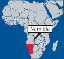
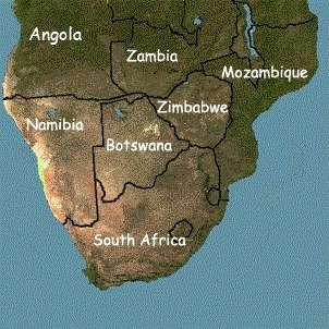
1 Satellite Earth Observation & Disaster Risks EO technologies for flood mapping and hydrological modelling in Namibia Guido Van Langenhove, Hydrological Services Namibia
2
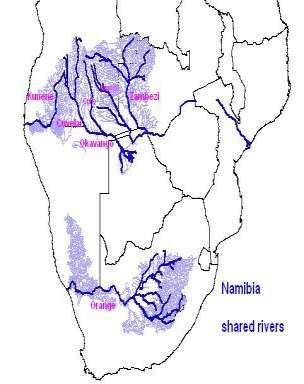
3 Hydrological trends in Namibia: Precipitations and riverflows seasonal and highly variable 1980s and 1990s rainfalls and riverflows were in general below-average Since 2000 rainfalls and riverflows have been in general above-average Exceptionally high rainfalls and floods in 2008, 2009, 2010 and 2011 Windhoek rainfall: 2010/11: > 1,000 mm, highest on record and 3 x normal (350 mm) Zambezi River: 2009: highest maximum (flood peak) since and 2011: lower peak, but longer duration and higher volume Kwando River: 2010: highest on record Okavango River : 2009 and again 2010: highest maximum (flood peak) since : lower peak, but longer duration and higher volume Cuvelai River : 2008: highest flood in living memory 2009: higher than : slightly lower 2011: again higher than 2009 Kunene River : 2011: highest on record Combined effects of climate variability and climate change?
4
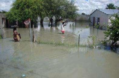
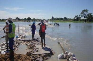
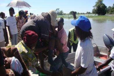
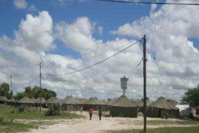
5 MAIN IMPACTS OF FLOODS: loss of human lives people moving to safer grounds and relocation camps waterborne diseases (malaria increase, cholera risk) disrupted, damaged and destroyed infrastructure and businesses interrupted access to schools, health services and other services set back socio-economic progress in the area and for Namibia as a whole 2009 FLOOD DISASTER IMPACT: 6 (out of 13) Regions in Namibia 677,000 people affected (1/3 of Namibian population) 105 people dead 56,000 people displaced 328 schools affected 94,000 school children affected 2009 POST DISASTER NEEDS ASSESSMENT (PDNA): Direct damages US$ million Housing, transport, commerce, industry Indirect losses: 78.2 US$ million Commerce, industry, agriculture, utilities Macro-economic impact: 0.6 % on Gross Domestic Product (GDP) of Namibia Recovery and reconstruction needs: US$ million
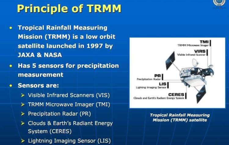
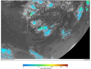
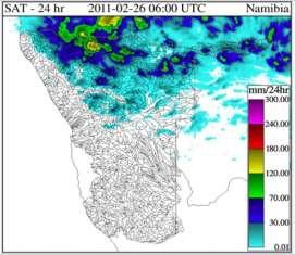
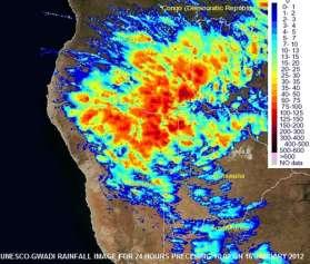
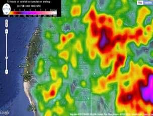
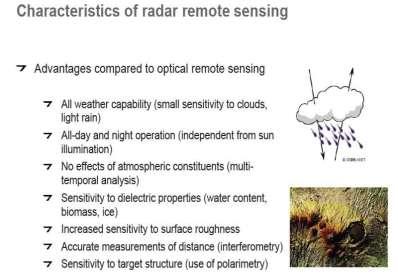
6 EO APPLICATION 1: AREAL PRECIPITATION MONITORING Physics of convective storms: vertical build-up cooling condensation Infra-red sensors indicate temperature and rainfall potential Combination with other bands that reflect cloud physics + moisture conditions Calibration issue USED IN NAMIBIA MeteoSat satellite: 15 minutes interval cloud images Eumetsat website: Near-real time images and interpretation also at night Various analytical processing systems - TRRM, FEWS, SWFDP, (SAR)FFGS, SERVIR, GWADI: Cumulative rainfall estimates for previous 1, 3, 6, 24, 48, 72 hours Calibration for Namibia? at least qualitative image
7
8
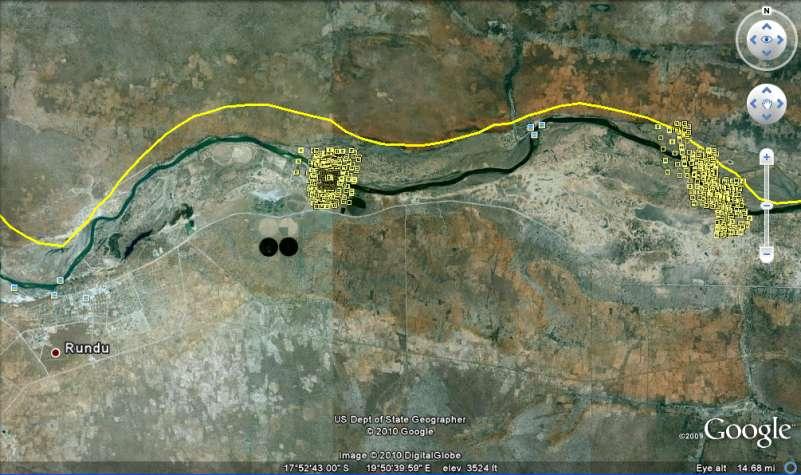
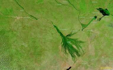
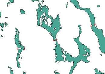
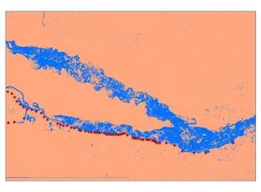
9 EO APPLICATION 2: RIVERFLOW MONITORING Direct monitoring of waterlevels In application for large lakes and rivers In reconnaissance phase for Namibia (TIGER-NET) Challenges: required width, location with direction, frequency, accuracy absolute and relative Direct monitoring of flow widths (with conversion to levels) Examples in literature (China) Indirect monitoring of flow widths (ditto) from pixel moisture JRC-EU + DFO-NASA Successfully applied in Namibia for Cuvelai (and Zambezi) Challenges: suitable sections, local rainfall, spikes
10


11 6 5 Evale Mar Mar Mar Mar Mar-2010
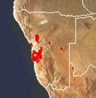
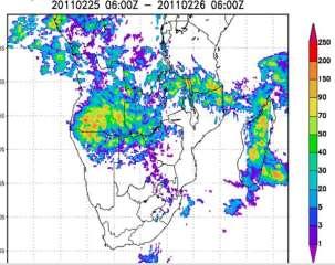
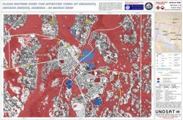
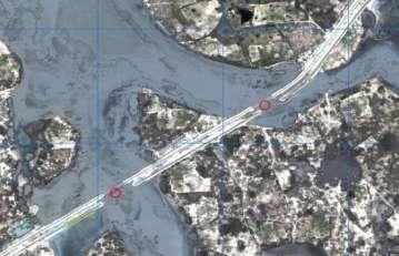
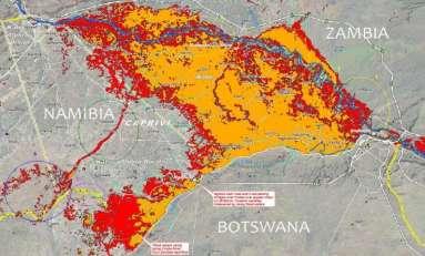
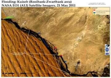
12 EO APPLICATION 3: FLOODMAPPING Applications Upstream floodwarning Drainage patterns Damages to infrastructure Roads Water carriers Areal flood extent Preparedness Response Long-term planning mitigation and measures Used in Namibia Optical: MODIS/Rapidfire (NASA), LandSat (NASA), Aster (USGS), EO-1 (NASA). Sumbadilasat (CSIR-SAC), SPOT (CNES) FormoSat (NSPO), WorldView and QuickBird (DigitalGlobe) Radar: Envisat SAR (ESA), Palsar/Alos (JAXA), RadarSat (CSA), TerraSar (DLR)


13 Selection of products Frequency of overflights Access to acquisition of scenes Near-real time availability of scenes Processing services/capabilities Area covered <-> resolution Optical <-> Radar Cost Space Charter activation
14
15
16
 Evaporation/")
17 EO APPLICATION 4: FLOOD MODELING/FORECASTING Testing phase Use near-real time information for: Rainfall Soil moisture Catchment conditions (vegetation) Evaporation/ evapo-transpiration
18 Merci Obrigado Thank you
Integrated Applications Programme (IAP) & Space for UAS UAS for Applications
 & Space for UAS UAS for Applications") ESA s Integrated Applications Programme (IAP) & Space for UAS UAS for Applications M. Vaissiere ESA Director of Telecommunications and Integrated Applications Programme European High Level UAS Conference
ESA s Integrated Applications Programme (IAP) & Space for UAS UAS for Applications M. Vaissiere ESA Director of Telecommunications and Integrated Applications Programme European High Level UAS Conference
Japan Earthquake and Tsunami: a view from satellite data
 Università degli studi di Roma Tor Vergata Corso di Telerilevamento e Cartografia Anno accademico 2012/2013 Japan Earthquake and Tsunami: a view from satellite data Dr. Matteo Picchiani picchiani@disp.uniroma2.it
Platform and Products
 International Partnership Space Programme Earth Observation for the Preservation of Ecological Bacalar Corridor Platform and Products Terri Freemantle, Raffaella Guida, Paula Marti, Pasquale Iervolino
HYDROLOGICAL SERVICES NAMIBIA- DAILY FLOOD BULLETIN: 09 March 2017
 Namibia Hydrological Services Private Bag 13184 Ministry of Agriculture, Water and Forestry Government Office Park Namibia Enquiries: Ms Pauline Mufeti Tel :( +264) 61 208 7191 Fax :( +264) 61 208 7256
Investigation on Development of Agricultural Monitoring System Using Satellite Data
 Investigation on Development of Agricultural Monitoring System Using Satellite Data Genya SAITO (1), Daisuke KUNII (1), Naoki ISHITSUKA (2) (1) Tohoku University, 1-1,Tsutsumidori Amamiya-machi Aoba-ku,
Time Series Evapotranspiration Mapping Using Landsat-TM and MODIS Data
 United States Department of Agriculture Time Series Evapotranspiration Mapping Using Landsat-TM and MODIS Data Agricultural Research Service SOIL & WATER MANGEMENT RESEARCH George Paul Prasanna Gowda Xiangming
HYDROLOGICAL SERVICES NAMIBIA- DAILY FLOOD BULLETIN: 06 March 2017
 Namibia Hydrological Services Private Bag 13184 Ministry of Agriculture, Water and Forestry Government Office Park Namibia Enquiries: Ms Pauline Mufeti Tel :( +264) 61 208 7191 Fax :( +264) 61 208 7256
Geospatial support for disasters - the Ohio Incident Management Team and the International Charter
 Geospatial support for disasters - the Ohio Incident Management Team and the International Charter 2011 Northern Midwest Public Safety GIS Workshop October 14, 2011 Glenview, IL Richard Kotapish, GISP
Actual Climatic Conditions in ERB. Online Resource 1 corresponding to:
 Actual Climatic Conditions in ERB. Online Resource 1 corresponding to: Article Title: Climatic Trends and Impact of Climate Change on Agriculture in an Arid Andean Valley. Journal Name: CLIMATIC CHANGE
Hydrology Input for West Souris River IWMP
 Hydrology Input for West Souris River IWMP Prepared by: Mark Lee Manitoba Water Stewardship 1 1 1 Overall view of: drainage area watershed characteristics gauging stations meteorological stations Runoff
Retreating Glaciers of the Himalayas: A Case Study of Gangotri Glacier Using Satellite Images
 Retreating Glaciers of the Himalayas: A Case Study of Gangotri Glacier Using 1990-2009 Satellite Images Jennifer Ding Texas Academy of Mathematics and Science (TAMS) Mentor: Dr. Pinliang Dong Department
Cal/Val Activities at the CIGSN Uardry Field Site, NSW, Australia in Support of the EO-1 Mission
 Cal/Val Activities at the CIGSN Uardry Field Site, NSW, Australia in Support of the EO-1 Mission Fred Prata and Graham Rutter CSIRO Atmospheric Research David Jupp CSIRO Earth Observation Centre EOC Annual
Papua New Guinea Disaster Risk Reduction Framework
 2018/SOM1/EPWG/014 Agenda Item: 8.2 Papua New Guinea Disaster Risk Reduction Framework Purpose: Information Submitted by: Papua New Guinea 13 th Emergency Preparedness Working Group Meeting Port Moresby,
DriDanube. Drought Risk in the Danube Region. Department of Geodesy and Geoinformation (GEO) Vienna University of Technology (TU Wien)
 Vienna University of Technology (TU Wien)") DriDanube Drought Risk in the Danube Region Department of Geodesy and Geoinformation (GEO) Vienna University of Technology (TU Wien) Vienna, 4 April 2018 DriDanube Drought Risk in the Danube Region Project
DriDanube Drought Risk in the Danube Region Department of Geodesy and Geoinformation (GEO) Vienna University of Technology (TU Wien) Vienna, 4 April 2018 DriDanube Drought Risk in the Danube Region Project
Community resources management implications of HKH hydrological response to climate variability
 Community resources management implications of HKH hydrological response to climate variability -- presented by N. Forsythe on behalf of: H.J. Fowler, C.G. Kilsby, S. Blenkinsop, G.M. O Donnell (Newcastle
Ground Deformation Monitoring at Natural Gas Production Sites using Interferometric SAR
 Ground Deformation Monitoring at Natural Gas Production Sites using Interferometric SAR By: Kanika Goel, Robert Shau, Fernando Rodriguez Gonzalez, Nico Adam Remote Sensing Technology Institute (IMF), German
Glacial lakes as sentinels of climate change in Central Himalaya, Nepal
 Glacial lakes as sentinels of climate change in Central Himalaya, Nepal Sudeep Thakuri 1,2,3, Franco Salerno 1,3, Claudio Smiraglia 2,3, Carlo D Agata 2,3, Gaetano Viviano 1,3, Emanuela C. Manfredi 1,3,
Snow, Glacier and GLOF
 Snow, Glacier and GLOF & Report on Demonstration River Basin Activities Upper Indus Basin The 5th International Coordination Group (ICG) Meeting GEOSS Asian Water Cycle Initiative (AWCI) Tokyo, Japan,
GEOSPATIAL ANALYSIS OF GLACIAL HAZARDS PRONE AREAS OF SHIGAR AND SHAYOK BASINS OF PAKISTAN. By Syed Naseem Abbas Gilany
 GEOSPATIAL ANALYSIS OF GLACIAL HAZARDS PRONE AREAS OF SHIGAR AND SHAYOK BASINS OF PAKISTAN By Syed Naseem Abbas Gilany PRESENTATION OUTLINE Introduction Problem Statement / Rationale Objectives Material
ADDRESSING ENVIRONMENTAL AND CLIMATE CHANGE CHALLENGES FACED BY CARIBBEAN SIDS THROUGH A SUSTAINABLE DEVELOPMENT LENS
 ADDRESSING ENVIRONMENTAL AND CLIMATE CHANGE CHALLENGES FACED BY CARIBBEAN SIDS THROUGH A SUSTAINABLE DEVELOPMENT LENS Marlene Attzs, PhD Deputy Coordinator, Sustainable Economic Development Unit (SEDU)
Shrubs and alpine meadows represent the only vegetation cover.
 Saldur river General description The study area is the upper Saldur basin (Eastern Italian Alps), whose elevations range from 2150 m a.s.l. (location of the main monitoring site, LSG) and 3738 m a.s.l.
DETECTION OF ICE FRONT INITIATION ON THE PEACE RIVER IN NORTHERN ALBERTA Freeze-up
 FINAL REPORT DETECTION OF ICE FRONT INITIATION ON THE PEACE RIVER IN NORTHERN ALBERTA Freeze-up 2013-2014 REFERENCE NO. CO 73797 Presented to: British Columbia Hydro and Power Authority Prepared by: Monique
New measurements techniques
 2 nd Asia CryoNetWorkshop New measurements techniques Xiao Cunde (SKLCS/CAS and CAMS/CMA) Feb.5, 2016, Salekhard, Russia Outline Definition of New Some relative newly-used techniques in China -- Eddy covariance
Jeneberang River. Serial No. : Indonesia-10 Location: South Sulawesi Area: 727 km 2 Origin: Mt. Bawakaraeng (2,833 MSL) Outlet: Makassar Strait
 Outlet: Makassar Strait") Jeneberang River Map of River Table of Basic Data Name: Jeneberang River Serial No. : Indonesia-10 Location: South Sulawesi S 5 10' 00" - 5 26' 00" E 119 23' 50" - 119 56' 10" Area: 727 km 2 Origin: Mt.
Jeneberang River Map of River Table of Basic Data Name: Jeneberang River Serial No. : Indonesia-10 Location: South Sulawesi S 5 10' 00" - 5 26' 00" E 119 23' 50" - 119 56' 10" Area: 727 km 2 Origin: Mt.
Observations of glacier dynamics with PALSAR DATA
 Observations of glacier dynamics with PALSAR DATA Tazio Strozzi, Urs Wegmüller and Charles Werner Gamma Remote Sensing, Gümligen, Switzerland Rhodes, Greece, 3 to 7 November 2008 Outline ESA GLOBGLACIER
Cau River. Map of River. Table of Basic Data. Vietnam 5
 Cau River Map of River Table of Basic Data Name: Cau River Location: Thai Nguyen, Province, Viet Nam Area: 6,030 km 2 Origin: Mt. Phia Deng 1,527 m Outlet: Pha Lai Note: * Indicates missing data in some
1. CLIMATIC AND ENVIRONMENTAL CONDITIONS OVER AFRICA. 1.1 Inter-Tropical Discontinuity (ITD)
") African Centre of Meteorological Application for Development Centre Africain pour les Applications de la Météorologie au Développement DECEMBER 2011 HIGHLIGHT: Cholera, Yellow fever, Avian Influenza, typhoid
African Centre of Meteorological Application for Development Centre Africain pour les Applications de la Météorologie au Développement DECEMBER 2011 HIGHLIGHT: Cholera, Yellow fever, Avian Influenza, typhoid
COSMO-Coast. L Aquila. La Sapienza. Tor Vergata. Dipartimento di Architettura ed Urbanistica. Dipartimento di Informatica, Sistemi e Produzione,
 COSMO-Coast Tor Vergata Dipartimento di Informatica, Sistemi e Produzione, L Aquila Dipartimento di Architettura ed Urbanistica La Sapienza Dipartimento Ingegneria Civile, Edile ed Ambientale Introduction
"ST. KLIMENT OHRIDSKI FACULTY OF GEOLOGY AND GEOGRAPHY
 SOFIA UNIVERSITY "ST. KLIMENT OHRIDSKI FACULTY OF GEOLOGY AND GEOGRAPHY APPLICATION OF THE MODEL "DRIVING FORCES PRESSURE STATE - RESPONSE FOR ASSESSMENT OF FLOOD RISK RADOSTINA BORISOVA DOCHEVA Bachelor
EO Contribution to Recovery Activities - A case study on the experience of the Great East Japan Earthquake -
 EO Contribution to Recovery Activities - A case study on the experience of the Great East Japan Earthquake - Michio Ito (Mr.) ito.michio@jaxa.jp Space Applications and Operation Center JAXA Purpose of
A high resolution glacier model with debris effects in Bhutan Himalaya. Orie SASAKI Kanae Laboratory 2018/02/08 (Thu)
") A high resolution glacier model with debris effects in Bhutan Himalaya Orie SASAKI Kanae Laboratory 2018/02/08 (Thu) Research flow Multiple climate data at high elevations Precipitation, air temperature
A high resolution glacier model with debris effects in Bhutan Himalaya Orie SASAKI Kanae Laboratory 2018/02/08 (Thu) Research flow Multiple climate data at high elevations Precipitation, air temperature
SARCOF-18 ANNOUNCEMENT
 THEME: Place: SARCOF-18 ANNOUNCEMENT Advancing Climate Information Services for Resilience Development in Southern Africa Region Windhoek, Namibia DATE: 27 29 August 2014 INTRODUCTION Southern Africa Development
Update on FLOODS in Nigeria
 EUROPEAN COMMISSION JOINT RESEARCH CENTRE Update on FLOODS in Nigeria JRC Emergency Report #021 Nigeria, 19th of September 2018 Executive Summary The National Emergency Management Agency (NEMA) informs
Using the Sentinels to map the state and changes of Norwegian glaciers
 /Copernicus Sentinel / Using the Sentinels to map the state and changes of Norwegian glaciers Liss Marie Andreassen, Solveig H. Winsvold, Andreas Kääb, Alexandra Messerli, Geir Moholdt, Suruchi Engelhardt,
Observation of cryosphere
 Observation of cryosphere By Sagar Ratna Bajracharya (email: sagar.bajracharya@icimod.org) Samjwal Ratna Bajracharya Arun Bhakta Shrestha International Centre for Integrated Mountain Development Kathmandu,
Tourism Towards 2030
 Tourism Towards 23 Agenda Item 5a 24 th Joint Meeting of the UNWTO Commission for East Asia and the Pacific and the UNWTO Commission for South Asia 4 May 212 Chiang Mai, Thailand million Tourism 22 Vision
THE TWENTY FIRST ANNUAL SOUTHERN AFRICA REGIONAL CLIMATE OUTLOOK FORUM MID-SEASON REVIEW AND UPDATE
 STATEMENT FROM THE TWENTY FIRST ANNUAL SOUTHERN AFRICA REGIONAL CLIMATE OUTLOOK FORUM (SARCOF-21) MID-SEASON REVIEW AND UPDATE, SADC HEADQUARTERS, GABORONE, BOTSWANA, 5 8 DECEMBER 2017. SUMMARY The bulk
5th NAMIBIA TOURISM SATELLITE ACCOUNT. Edition
 5th NAMIBIA TOURISM SATELLITE ACCOUNT Edition PREFACE I am pleased to present to you the 5 th edition of the Tourism Satellite Account (TSA). TSA is an accounting framework and economic statistical tool
Watershed Runoff Analysis
 CREATING SOLUTIONS FOR A CHANGING WORLD Watershed Runoff Analysis April 18, 2017 John Melack, UCSB Ed Beighley & Dongmei Feng, Northeastern University Study Workflow Civil and Environmental Engineering
THE WORLD BANK. Climate Change Adaptation and Natural Disasters Preparedness in the Coastal Cities of North Africa
 THE WORLD BANK Climate Change Adaptation and Natural Disasters Preparedness in the Coastal Cities of North Africa Phase 1 : Risk Assessment for the Present Situation and Horizon 2030 Alexandria Area National
Queensland Reconstruction Authority Rebuilding a stronger, more resilient Queensland
 Queensland Reconstruction Authority Rebuilding a stronger, more resilient Queensland The capacity to prepare for, withstand, respond to and recover from disasters The capacity to prepare for, withstand,
Southern Africa Growing Season : Heading for a Record Drought?
 Southern Africa Growing Season 2015-2016: Heading for a Record Drought? HIGHLIGHTS The current growing season (October 2015 April 2016) in Southern Africa is developing under the peak phase of El Nino
MARINA BOLADO PENAGOS A METHODOLOGY TO ASSESS THE ROLE OF THE RIVER DISCHARGES TO THE GULF OF CADIZ ON THE NUTRIENT SUPPLY TO THE ALBORAN SEA
 MARINA BOLADO PENAGOS A METHODOLOGY TO ASSESS THE ROLE OF THE RIVER DISCHARGES TO THE GULF OF CADIZ ON THE NUTRIENT SUPPLY TO THE ALBORAN SEA INTRODUCTION General MEGAN Project Case Study Guadalquivir
Cusco floods in 2010 Laura Paccini 1, Luis Orihuela 1
 WWOSC 2014 MONTRÉAL, CANADA Cusco floods in 2010 Laura Paccini 1, Luis Orihuela 1 1 Universidad Nacional Agraria La Molina Cusco Region Location Population Climate Southeast of Peru 11 10 15 20 S 70 10
The impact of climate change on glaciers and glacial runoff in Iceland
 The impact of climate change on glaciers and glacial runoff in Iceland Bergur Einarsson 1, Tómas Jóhannesson 1, Guðfinna Aðalgeirsdóttir 2, Helgi Björnsson 2, Philippe Crochet 1, Sverrir Guðmundsson 2,
THE PROBLEMS AND PROSPECTS OF DOMESTIC TOURISM SECTOR IN SRI LANKA. (A Case Study on Kataragama Sacred City and Yala (Ruhuna) National Park).
 National Park).") ~/ J" ~,~oo0t- ~ THE PROBLEMS AND PROSPECTS OF DOMESTIC TOURISM SECTOR IN SRI LANKA (A Case Study on Kataragama Sacred City and Yala (Ruhuna) National Park). by M. SUNIL SHANTHA A Thesis Submitted to the
~/ J" ~,~oo0t- ~ THE PROBLEMS AND PROSPECTS OF DOMESTIC TOURISM SECTOR IN SRI LANKA (A Case Study on Kataragama Sacred City and Yala (Ruhuna) National Park). by M. SUNIL SHANTHA A Thesis Submitted to the
Figure Pre- and post-disaster satellite topographical maps
 2.1.3 Image analysis by JAXA JAXA conducted ongoing emergency observations using Daichi in the wake of the Great East Japan Earthquake, releasing reporting of its analysis of eastern Japan and Hokkaido
Climate Change Impact on Water Resources of Pakistan
 Pakistan Water and Power Development Authority (WAPDA) Climate Change Impact on Water Resources of Pakistan Glacier Monitoring & Research Centre Muhammad Arshad Pervez Project Director (GMRC) Outline of
Impacts of climate change on the hydrological processes in the Mekong River. Hui Lu & Wei Wang Tsinghua University
 1 Impacts of climate change on the hydrological processes in the Mekong River Hui Lu & Wei Wang Tsinghua University Outline Backgrounds Method and data Model calibration Temperature and rainfall trends
Using of space technologies for glacierand snow- related hazards studies
 United Nations / Germany international conference on International Cooperation Towards Low-Emission and Resilient Societies Using of space technologies for glacierand snow- related hazards studies Bonn,
Evolution of Ossoue glacier, French Pyrenees: Tools and methods to generate a regional climate-proxy
 Evolution of Ossoue glacier, French Pyrenees: Tools and methods to generate a regional climate-proxy Renaud MARTI ab, Simon GASCOIN a, Thomas HOUET b, Dominique LAFFLY b, Pierre RENE c a CESBIO b GEODE,
Summary of the 25 FASTEX cases
 Part 3 ummary of the 25 FATEX cases by Alain Joly, éatrice Pouponneau, Geneviève Jaubert, Catherine Piriou. Météo-France, URA CNR 1357, Groupe d Etude de l Atmosphère Météorologique, Toulouse, France.
Public Works Research Institute
 Public Works Research Institute INTERNATIONAL WORKSHOP ON WATER HAZARD AND RISK MANAGEMENT SOME EXPERIENCES OF FLOOD MANAGEMENT IN ARGENTINA VÍCTOR POCHAT National Director for Water Policies,Coordination
Fifty-Year Record of Glacier Change Reveals Shifting Climate in the Pacific Northwest and Alaska, USA
 Fact Sheet 2009 3046 >> Pubs Warehouse > FS 2009 3046 USGS Home Contact USGS Search USGS Fifty-Year Record of Glacier Change Reveals Shifting Climate in the Pacific Northwest and Alaska, USA Fifty years
Presentation Overview
 DON NARROWS Historical and Existing Conditions March 29, 2008 Presentation Overview 1. Project Location and Background 2. Historical Context How did the Don Narrows Come to Be? 3. The Today 4. Next Steps
Occurrence of Dry and Wet Periods in Altitudinal Vegetation Stages of West Carpathians in Slovakia: Time-Series Analysis
 Occurrence of Dry and Wet Periods in Altitudinal Vegetation Stages of West Carpathians in Slovakia: Time-Series Analysis 1951-2005 J. Hrvoľ,, J. J Škvarenina,, J. J Tomlain, J. Škvareninová,, P. Nejedlík
Table Major analysis products provided by JAXA
 Report on JAXA s Response to the Great East Japan Earthquake - Assistance using earth observation satellites and communication satellites - 2.1.5 Product provision and utilization by users for disaster
Indian Ocean Small Island States: Indicators of Dangerous Anthropogenic Influences of Climate Change?
 Indian Ocean Small Island States: Indicators of Dangerous Anthropogenic Influences of Climate Change? Prepared for: AGU Fall Meeting San Francisco CA December 5, 2005 Prepared by: Bill Mills Chih-Fang
Land Figures & Spatial Data Infrastructure in KOSOVO
 Land Figures & Spatial Data Infrastructure in KOSOVO Idriz SHALA idriz.shala@gmail.com GIS -expert Afrim SHARKU afrim.sharku@gmail.com Land Management - Expert Kick-off meeting of the Regional Expert Advisory
Disaster Prevention Monitoring in a Vulnerable Environment Mahabir Pun
 Disaster Prevention Monitoring in a Vulnerable Environment Mahabir Pun Nepal Wireless Project Nepal Research & Education Network 14 April 2008, Japan My Involvement Chairman, the Institute for Himalayan
The 2nd Glacier Inventory of China
 The 2nd Glacier Inventory of China LIU Shiyin Guo Wanqin, Xu Junli, Shangguan Donghui, Wei Junfeng, Wu Lizong, Yu Pengchun, Li Jing, Liu Qiao State Key Laboratory of Cryospheric Sciences, Cold and Arid
NORTH CASCADE SLACIER CLIMATE PROJECT Director: Dr. Mauri S. Pelto Department of Environmental Science Nichols College, Dudley MA 01571
 NORTH CASCADE SLACIER CLIMATE PROJECT Director: Dr. Mauri S. Pelto Department of Environmental Science Nichols College, Dudley MA 01571 INTRODUCTION The North Cascade Glacier-Climate Project was founded
The Role of Glaciers in the Hydrologic Regime of the Nepal Himalaya. Donald Alford Richard Armstrong NSIDC Adina Racoviteanu NSIDC
 The Role of Glaciers in the Hydrologic Regime of the Nepal Himalaya Donald Alford Richard Armstrong NSIDC Adina Racoviteanu NSIDC Outline of the talk Study area and data bases Area altitude distributed
Presentation from 2015 World Water Week in Stockholm. The authors, all rights reserved. SIWI siwi.org
 Presentation from 2015 World Water Week in Stockholm www.worldwaterweek.org The authors, all rights reserved SIWI siwi.org WORLD WATER WEEK Stockholm, 23 th August 2015 Co-operative water governance: catalyst
NAMIBIA: CAPRIVI FLOODS
 NAMIBIA: CAPRIVI FLOODS 23 May 2003 Information Bulletin N 2/2003 Disaster Relief Emergency Fund (DREF) allocated: N/A The Federation s mission is to improve the lives of vulnerable people by mobilizing
FORT LAUDERDALE-HOLLYWOOD INTERNATIONAL AIRPORT ENVIRONMENTAL IMPACT STATEMENT DRAFT
 D.3 RUNWAY LENGTH ANALYSIS Appendix D Purpose and Need THIS PAGE INTENTIONALLY LEFT BLANK Appendix D Purpose and Need APPENDIX D.3 AIRFIELD GEOMETRIC REQUIREMENTS This information provided in this appendix
Just how big is Africa?
 The United States China India The United Kingdom Portugal Spain France Belgium Germany The Netherlands Switzerland Italy Eastern Europe Japan 11.7 million sq. miles Just how big is Africa? Chapter 18 Section
Summary table of disaster occurrences, by hazards types, scale, and geographic region
 ANNEX BASIC RANGE OF DISASTER-RELATED STATISTICS TABLES Statistical tables are organised into worksheets according to basic components in the DSRF. The variables represent queries from a disaster-related
Glacial Lake Outburst Flood Mitigation Measures, Monitoring and Early Warning Systems
 Chapter 12 Glacial Lake Outburst Flood Mitigation Measures, Monitoring and Early Warning Systems There are several possible methods for mitigating the impact of Glacial Lake Outburst Flood (GLOF) surges,
KNOWLEDGE NOTE 1-3. Hydro-meteorological Disasters Associated with Tsunamis and Earthquakes. CLUSTER 1: Structural Measures
 Public Disclosure Authorized Public Disclosure Authorized Public Disclosure Authorized Public Disclosure Authorized KNOWLEDGE NOTE 1-3 CLUSTER 1: Structural Measures Hydro-meteorological Disasters Associated
NATIONAL SENIOR CERTIFICATE NATIONAL GRADE 12
 NATIONAL SENIOR CERTIFICATE NATIONAL GRADE 12 GEOGRAPHY P1 FEBRUARY/MARCH 2013 ANNEXURE This annexure consists of 12 pages. Geography/P1 2 DBE/Feb. Mar. 2013 FIGURE 1.1: GLOBAL PRESSURE BELTS AND WINDS
Southern Africa Floods Situation Update# 3 2 February 2011
 Southern Africa Floods Situation Update# 3 2 February 2011 This report was issued by the Regional Office for Southern & Eastern Africa (ROSEA). It covers the period from 27 January to 2 February 2011.
Prospects for international tourism
 Prospects for international tourism Project LINK UN DESA Expert Group Meeting on the World Economy, NYC, USA 24-26 October 211 John G.C. Kester Programme Manager, Tourism Trends and Marketing Strategies
AIRBORNE SCIENCE FLIGHT REQUEST National Aeronautics and Space Administration
 AIRBORNE SCIENCE FLIGHT REQUEST National Aeronautics and Space Administration LOG NUMBER Investigation Title: Rationale for use of NASA Facilities: NASA RTOP If checked, RTOP Number/Grant or Contract #
MADAGASCAR: POST-FLOOD FOOD SECURITY AND CHOLERA PREVENTION
 MADAGASCAR: POST-FLOOD FOOD SECURITY AND CHOLERA PREVENTION appeal no: 13/98 3 April 1998 THIS APPEAL SEEKS CHF 258,000 IN CASH, KIND AND SERVICES TO ASSIST 20,000 BENEFICIARIES FOR 3 MONTHS Summary Torrential
4 *Contours generalized for estimating average watershed precipitation; adopted from larger map by Geomatrix, 1999.
 Selected USGS Stream Gaging Stations San Lorenzo River watershed A. Pescadero Ck B. San Lorenzo R. Waterman Switch C. Boulder Ck D. Zayante Ck E. Bean Ck F. San Vicente Ck G. San Lorenzo R. at Big Trees
CANADA CARIBBEAN DISASTER RISK MANAGEMENT FUND. Island Snapshot. Trinidad and Tobago
 Island Snapshot Trinidad and Tobago About the CCDRMF The Canada Caribbean Disaster Risk Management Fund (CCDRMF) is one component of Global Affairs Canada s 1 (GAC) larger regional Caribbean Disaster Risk
Impacts of climate change and water induced disasters in high altitude on hydropower development in Nepal. Rijan Bhakta Kayastha, D. Sc.
 Impacts of climate change and water induced disasters in high altitude on hydropower development in Nepal Rijan Bhakta Kayastha, D. Sc. Associate Professor and Coordinator Himalayan Cryosphere, Climate
Emergency Relief Efforts of 2008 China Extreme Ice-snow Storms
 Workshop on Large-Scale Disaster Recovery in APEC Emergency Relief Efforts of 2008 China Extreme Ice-snow Storms Dr. LAI Hongzhou, Deputy Director of Department of Emergency, National Disaster Reduction
CONGESTION MONITORING THE NEW ZEALAND EXPERIENCE. By Mike Curran, Manager Strategic Policy, Transit New Zealand
 CONGESTION MONITORING THE NEW ZEALAND EXPERIENCE 26 th Australasian Transport Research Forum Wellington New Zealand 1-3 October 2003 By, Manager Strategic Policy, Transit New Zealand Abstract New Zealand
UNFCCC Expert Meeting on Loss and Damage
 UNFCCC Expert Meeting on Loss and Damage Small Island Developing States Group Barbados October 9 11, 2012 CARIBBEAN COMMUNITY CLIMATE CHANGE CENTRE The CCCCC CARICOM Specialised Institution Coordinating
ICPAC. IGAD Climate Prediction and Applications Centre Monthly Bulletin, February 2017
 IGAD CLIMATE PREDICTION AND APPLICATIONS CENTRE ICPAC Bulletin Issue March 2017 Issue Number: ICPAC/02/299 IGAD Climate Prediction and Applications Centre Monthly Bulletin, February 2017 For referencing
Hydro-Hegemony in the Context of the South African Cold War Experience
 HydroHegemony in the Context of the South African Cold War Experience 1 st Workshop on HydroHegemony 2122 May 2005 Kings College London Dr. Anthony Turton GibbSERA Chair in Integrated Water Resource Management
EVALUATION OF DIFFERENT METHODS FOR GLACIER MAPPING USING LANDSAT TM
 EVALUATION OF DIFFERENT METHODS FOR GLACIER MAPPING USING LANDSAT TM Frank Paul Department of Geography, University of Zurich, Switzerland Winterthurer Strasse 190, 8057 Zürich E-mail: fpaul@geo.unizh.ch,
4/28/17. Clicker Question. Clicker Question. #37 Floods IV (Case Histories-Mississippi River Flood, 1993; Red River of North Flood, 1997)
") GEOL 118 Final Exam Format similar to exams 1 and 2 Covers Lectures #27 40 (Global Climate Change I - Meteorite Impacts III) Web Exercise #6 - Due by 1 pm, Monday (5/1) 8:00 AM, Thursday, May 11 th Location
GEOL 118 Final Exam Format similar to exams 1 and 2 Covers Lectures #27 40 (Global Climate Change I - Meteorite Impacts III) Web Exercise #6 - Due by 1 pm, Monday (5/1) 8:00 AM, Thursday, May 11 th Location
PDC Members. Charter Members. Technology & Honorary Members. There is clearly a cross over 5/31/2017
 UAS A Tool for Commercial and Government Application Partnership SCARC 2017 Charles Mondello Eagleview Stategist & President Property Drone Consortium 1 The PDC is a consortium among insurance carriers,
HISTORICAL FLOOD LEVELS
 5.36 5.02 3.58 3.59 3.68 3.67 3.21 2.87 3.01 2.91 2.8 3.78 2.42 4.02 2.4 2.37 2.35 2.06 2.41 2.39 2.39 2.37 2.39 2.4 2.39 2.14 2.06 2.39 2.41 2.42 2.31 2.14 2.3 1.5 2.38 2.16 2.43 1.5 2.43 1.91 4.93 4.63
Annual bulletin 2014
 Annual bulletin 2014 1 --------------------------Temperature----------------------- January 2014 In January 2014 it was warmer than normal nearly over the complete region with exception of the northern
NASA s Air Traffic Management Research Shon Grabbe SMART-NAS for Safe TBO Project Manager. Graphic: NASA/Maria Werries
 NASA s Air Traffic Management Research Shon Grabbe SMART-NAS for Safe TBO Project Manager Graphic: NASA/Maria Werries 1 Why is aviation so important? The air transportation system is critical to U.S. economic
ZAMBIA: KAZUNGULA FLOODS
 ZAMBIA: KAZUNGULA FLOODS No. MDRZM002 31 March 2006 The Federation s mission is to improve the lives of vulnerable people by mobilizing the power of humanity. It is the world s largest humanitarian organization
Chapter 7 Snow and ice
 Chapter 7 Snow and ice Throughout the solar system there are different types of large ice bodies, not only water ice but also ice made up of ammonia, carbon dioxide and other substances that are gases
Thailand 12. Pasak River. Map of River
 Pasak River Map of River 232 Table of Basic Data Name: Pasak river Serial No. : Thailand-12 Location: Central part of Thailand N 14 21' 44" ~ 17 06' 02" E 100 34' 40" ~ 101 32' 56" Area: 15,779 km 2 Length
Airborne Remote Sensing Component of Marine Debris Monitoring
 Airborne Remote Sensing Component of Marine Debris Monitoring Dr. Thomas H Mace Mace Geospatial, LLC Workshop on Mission Concepts for Marine Debris Sensing Honolulu, Hi, Jan 19 21, 2016 Multistage Remote
Post tsunami Recovery of Port and Harbor areas in Japan from the 2011 Great East Japan Earthquake Tsunami
 Date : 18 Nov., 2015 Venue : Furama Ballroom 1 SESSION 1 : A Decade of Partnerships in Sustainable Development of the Seas of East Asia: Synergies and Achievements WORKSHOP 1.1 : Managing Risks in Climate
SPATIO TEMPORAL CHANGE OF SELECTED GLACIERS ALONG KARAKORAM HIGHWAY FROM USING REMOTE SENSING AND GIS TECHNIQUES
 SPATIO TEMPORAL CHANGE OF SELECTED GLACIERS ALONG KARAKORAM HIGHWAY FROM 1994-217 USING REMOTE SENSING AND GIS TECHNIQUES Yasmeen Anwar 1, Javed Iqbal 2 1 National University of Sciences and Technology
Hydrology of Recent Flooding in South East Queensland
 Hydrology of Recent Flooding in South East Queensland G. Hausler TOPICS Prelude eu e Rainfalls Catchments Flooding Aftermath Prelude Sea Surface Temperature anomalies for December 2010 Most likely return
How Internet can be used for climate change monitoring, early warning and mitigation in the Himalayas? Guarab Raj Upadhaya
 How Internet can be used for climate change monitoring, early warning and mitigation in the Himalayas? Guarab Raj Upadhaya Nepal Wireless Project Nepal Research & Education Network December 4, 2008 My
Project Management, Environmental Assessment, Stormwater Management. Hydrologic Modelling. Natural Heritage. Fluvial Geomorphology
 Welcome PUBLIC INFORMATION CENTRE # 1 KROSNO CREEK DIVERSION PROJECT February 19, 2014 6:30 p.m. to 8:30 p.m. Please sign in on the sheet provided. Then feel free to walk around and view the displays.
STATEMENT DELIVERED BY DR. DOUGLAS SLATER ON BEHALF OF THE SECRETARY-GENERAL CARIBBEAN COMMUNITY (CARICOM) FOR THE
 FOR THE") STATEMENT DELIVERED BY DR. DOUGLAS SLATER ON BEHALF OF THE SECRETARY-GENERAL CARIBBEAN COMMUNITY (CARICOM) FOR THE SPECIAL MEETING OF THE ECONOMIC AND SOCIAL COUNCIL (ECOSOC) NEW YORK, USA 24 OCTOBER 2017
STATEMENT DELIVERED BY DR. DOUGLAS SLATER ON BEHALF OF THE SECRETARY-GENERAL CARIBBEAN COMMUNITY (CARICOM) FOR THE SPECIAL MEETING OF THE ECONOMIC AND SOCIAL COUNCIL (ECOSOC) NEW YORK, USA 24 OCTOBER 2017
Characteristic of Heavy Rainfall Disaster in Central Area of Japan on September 11 to 12, USHIYAMA Motoyuki*, TAKARA Kaoru*
 Characteristic of Heavy Rainfall Disaster in Central Area of Japan on September 11 to 12, 2000 USHIYAMA Motoyuki*, TAKARA Kaoru* *Disaster Prevention Research Institute, Kyoto University, Japan. 1. Introduction