Observations of glacier dynamics with PALSAR DATA
|
|
|
- Reynold Heath
- 5 years ago
- Views:
Transcription

1 Observations of glacier dynamics with PALSAR DATA Tazio Strozzi, Urs Wegmüller and Charles Werner Gamma Remote Sensing, Gümligen, Switzerland Rhodes, Greece, 3 to 7 November 2008
2 Outline ESA GLOBGLACIER project Offset tracking of satellite SAR images Case studies in the Arctic: Novaya Zemlya, Svalbard, Alaska, Baffin Island Conclusions and recommendations
3 GLOBGLACIER The ESA GlobGlacier project is attempting to establish a service for glacier monitoring from space that complements the existing network for global glacier monitoring GlobGlacier products have been identified by the user group: - digital glacier outlines - terminus position - topography - changes in glacier surface elevation - snow covered area and elevation of the transient snowline - velocity fields Velocity fields for glaciers will be obtained either from feature tracking of repeat pass optical imagery or active microwave sensors using differential SAR interfeometry or SAR offsettracking
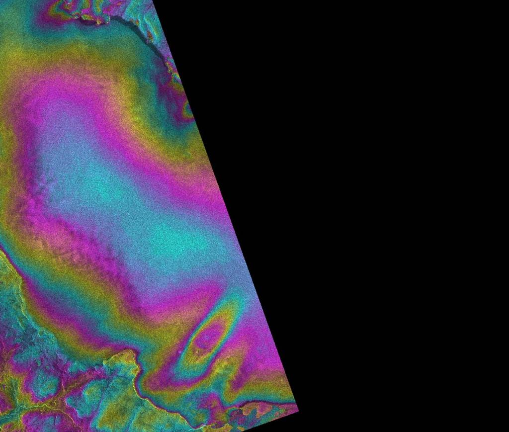
4 Offset tracking of satellite SAR images With offset tracking the registration offsets of two SAR images in both slant-range (i.e. in the line-of-sight of the satellite) and azimuth (i.e. along the orbit of the satellite) directions are generated and used to estimate the displacement of glaciers Offset-tracking is a robust and direct alternative technique to InSAR for the estimation of glacier motion in the case of rapid flow and large acquisition time intervals

 ΔR z B R sinθ z=3000m, B =300m, ΔR=2m d Δx ~ (")
5 Offset tracking of satellite SAR images 0 pixel _ range azimuth offset tracking PALSAR 46 days original offsets flight direction (azimuth x) line-of-sight (range R) ΔR z B R sinθ z=3000m, B =300m, ΔR=2m d Δx ~ ( ΔTotalElectonContent dx ) / fo2
 co-registration with DEM filter line-of-sight (range")
6 Offset tracking of satellite SAR images 0 pixel _ range azimuth offset tracking PALSAR 46 days filterered offsets flight direction (azimuth x) co-registration with DEM filter line-of-sight (range R)

7 Offset tracking of satellite SAR images Swiss Alps / days 300 m 0 m/year 250
 500 m 192 * 3.")
 250 m 128 * 1.")

8 Grosse Aletschgletscher (Switzerland) 0 m/year * 4.67 m / sin (38) 500 m 192 * 3.15 m 600 m > PALSAR 128 * 1.36 m / sin (44) 250 m 128 * 1.98 m 250 m > TSX ALOS PALSAR days, 300 m TerraSAR-X days, 280 m ERS-1/ (1 day, 34 m)
")


 25.06.")
9 Gornergletscher (Switzerland) PALSAR / m/year <5 50 >500 Gamma Portable Radar Interferometer ERS 07/ (horizontal plane) time interval ~1 hour
 Time series analysis Track 525, Frame")
10 Novaya Zemlya (Russia) ALOS PALSAR (L-band, 46 days repeat cycle) Time series analysis Track 525, Frame 1520
11 Novaya Zemlya (Russia) 0 m/year 300 Offset tracking _ ALOS PALSAR FBS-FBS 46 days Background is MODIS imagery from July 29, 2003 Outlet glacier boundaries are after The catalogue of glaciers of the USSR (1978)

12 Novaya Zemlya (Russia) 0 m/year 300 Offset tracking _ ALOS PALSAR FBD-FBD 46 days Background is MODIS imagery from July 29, 2003 Outlet glacier boundaries are after The catalogue of glaciers of the USSR (1978)
13 Novaya Zemlya (Russia) 0 m/year 300 Offset tracking _ ALOS PALSAR FBD-FBD 46 days Background is MODIS imagery from July 29, 2003 Outlet glacier boundaries are after The catalogue of glaciers of the USSR (1978)
14 Novaya Zemlya (Russia) 0 m/year 300 Offset tracking _ ALOS PALSAR FBD-FBS 92 days Background is MODIS imagery from July 29, 2003 Outlet glacier boundaries are after The catalogue of glaciers of the USSR (1978)
15 Novaya Zemlya (Russia) 0 m/year 300 Offset tracking _ ALOS PALSAR FBS-FBS 46 days Background is MODIS imagery from July 29, 2003 Outlet glacier boundaries are after The catalogue of glaciers of the USSR (1978)
 0 500 400 300 200 100 0 25 50 75 100 125 150 175")
16 0 m/year 300 Novaya Zemlya (Russia) Velocity (m/year) _ _ _ _ _ Velocity (m/year) _ _ _ _ _ Velocity (m/year) _ _ _ _ _

17 Vestfonna-Austfonna, Svalbard (Norway) N 3-dim. Ascending orbits ALOS PALSAR offsettracking 0 m/year 300 Expected errors are about ±10 m/year 2 Tracks / (W) / (E) 46 days

18 Vestfonna-Austfonna, Svalbard (Norway) N 3-dim. Ascending / descending orbits ERS INSAR & offsettracking 0 m/year 300 Expected errors are about ±2 cm/day (±7 m/year) 4 Tracks Dec. 95 / Jan day

19 Vestfonna-Austfonna, Svalbard (Norway) N 3-dim. Descending orbits JERS-1 SAR offsettracking 0 m/year 300 Expected errors are about ±20 m/year 2 Tracks / (W) / (E) 44 days
 20080105")
20 Vestfonna-Austfonna, Svalbard (Norway) N 3-dim. Ascending orbits ALOS PALSAR 2 Tracks / (W) / (E) 46 days

21 Kenai Peninsula, Alaska (USA) ALOS PALSAR (L-band, 46 days repeat cycle)

22 Kenai Peninsula, Alaska (USA) Offset tracking _ ALOS PALSAR FBS-FBS 46 days 0 m/year 300

23 Kenai Peninsula, Alaska (USA) ERS InSAR _ day -134 m descending orbit _ not yet available 2π

24 Chigmit Mountains, Alaska (USA) ALOS PALSAR (L-band, 46 days repeat cycle)

25 Chigmit Mountains, Alaska (USA) Offset tracking _ ALOS PALSAR FBS-FBS 46 days 0 m/year 300

26 Chigmit Mountains, Alaska (USA) ERS InSAR _ day -73 m descending orbit 2π

27 Baffin Island (Canada) ALOS PALSAR (L-band, 46 days repeat cycle)


28 Baffin Island (Canada) Offset tracking _ ALOS PALSAR, FBS-FBS, 46 days 0 m/year 100

29 Baffin Island (Canada) 0 m/year 100 Offset tracking _ ALOS PALSAR, FBS-FBS, 46 days

30 Baffin Island (Canada) InSAR _ ALOS PALSAR, FBS-FBS, 46 days
 InSAR")
31 Baffin Island (Canada) InSAR _ ERS-1/2 SAR, 1 day
32 Outlook and recommendations Use of ALOS PALSAR FBS and FBD data for the estimation of the motion of glaciers with offset tracking resulted in remarkably good outcomes in many regions around the world. For a more global use of ALOS PALSAR data in glacier dynamics the acquisition of a more consistent set of image pairs separated by a full orbital cycle of 46 days is required over glacier-covered regions, in particular in the Arctic. The ALOS PALSAR acquisition strategy features routine observations, that are currenlty not fully adapted to glacier motion studies. Is there the possibility to update the ALOS PALSAR acquisition strategy at continental scale in Arctic and Antarctic regions?

33 Thank you for your attention
Ground Deformation Monitoring at Natural Gas Production Sites using Interferometric SAR
 Ground Deformation Monitoring at Natural Gas Production Sites using Interferometric SAR By: Kanika Goel, Robert Shau, Fernando Rodriguez Gonzalez, Nico Adam Remote Sensing Technology Institute (IMF), German
Using the Sentinels to map the state and changes of Norwegian glaciers
 /Copernicus Sentinel / Using the Sentinels to map the state and changes of Norwegian glaciers Liss Marie Andreassen, Solveig H. Winsvold, Andreas Kääb, Alexandra Messerli, Geir Moholdt, Suruchi Engelhardt,
COSMO-Coast. L Aquila. La Sapienza. Tor Vergata. Dipartimento di Architettura ed Urbanistica. Dipartimento di Informatica, Sistemi e Produzione,
 COSMO-Coast Tor Vergata Dipartimento di Informatica, Sistemi e Produzione, L Aquila Dipartimento di Architettura ed Urbanistica La Sapienza Dipartimento Ingegneria Civile, Edile ed Ambientale Introduction
Satellite-based measurement of the surface displacement of the largest glacier in Austria
 Conference Volume 4 th Symposium of the Hohe Tauern National Park for Research in Protected Areas September 17 th to 19 th, 2009, Castle of Kaprun pages 145-149 Satellite-based measurement of the surface
Investigation on Development of Agricultural Monitoring System Using Satellite Data
 Investigation on Development of Agricultural Monitoring System Using Satellite Data Genya SAITO (1), Daisuke KUNII (1), Naoki ISHITSUKA (2) (1) Tohoku University, 1-1,Tsutsumidori Amamiya-machi Aoba-ku,
Using of space technologies for glacierand snow- related hazards studies
 United Nations / Germany international conference on International Cooperation Towards Low-Emission and Resilient Societies Using of space technologies for glacierand snow- related hazards studies Bonn,
EVALUATION OF DIFFERENT METHODS FOR GLACIER MAPPING USING LANDSAT TM
 EVALUATION OF DIFFERENT METHODS FOR GLACIER MAPPING USING LANDSAT TM Frank Paul Department of Geography, University of Zurich, Switzerland Winterthurer Strasse 190, 8057 Zürich E-mail: fpaul@geo.unizh.ch,
VOLUME CHANGES OF THE GLACIERS IN SCANDINAVIA AND ICELAND IN THE 21st CENTURY
 VOLUME CHANGES OF THE GLACIERS IN SCANDINAVIA AND ICELAND IN THE 21st CENTURY Valentina Radić 1,3 and Regine Hock 2,3 1 Depart. of Earth & Ocean Sciences, University of British Columbia, Vancouver, Canada
New measurements techniques
 2 nd Asia CryoNetWorkshop New measurements techniques Xiao Cunde (SKLCS/CAS and CAMS/CMA) Feb.5, 2016, Salekhard, Russia Outline Definition of New Some relative newly-used techniques in China -- Eddy covariance
A SEGMENTED ARCHITECTURE APPROACH TO PROVIDE A CONTINUOUS, LONG-TERM, ADAPTIVE AND COST- EFFECTIVE GLACIERS MONITORING SYSTEM
 1st IAA Latin American Symposium on Small Satellites: Advanced Technologies and Distributed Systems A SEGMENTED ARCHITECTURE APPROACH TO PROVIDE A CONTINUOUS, LONG-TERM, ADAPTIVE AND COST- EFFECTIVE GLACIERS
Retreating Glaciers of the Himalayas: A Case Study of Gangotri Glacier Using Satellite Images
 Retreating Glaciers of the Himalayas: A Case Study of Gangotri Glacier Using 1990-2009 Satellite Images Jennifer Ding Texas Academy of Mathematics and Science (TAMS) Mentor: Dr. Pinliang Dong Department
Lowell Glacier LOS Flow Rate descending orbits. Lowell Glacier LOS Flow Rate ascending orbits. LOS displacement (cm/day) Glacier centreline (km)
 Glacier centreline (km)") Measuring the 3-D Flow of the Lowell Glacier with InSAR Ian Cumming and Joe Zhang Dept. of Electrical and Computer Engineering The University of British Columbia, Vancouver, BC, Canada V6T 1Z4. Email:
Measuring the 3-D Flow of the Lowell Glacier with InSAR Ian Cumming and Joe Zhang Dept. of Electrical and Computer Engineering The University of British Columbia, Vancouver, BC, Canada V6T 1Z4. Email:
Hazard assessment of glacial lake outburst floods from Kyagar glacier, Karakoram mountains, China
 34 Annals of Glaciology (55)66 2014 doi: 10.3189/2014AoG66A001 Hazard assessment of glacial lake outburst floods from Kyagar glacier, Karakoram mountains, China Christoph HAEMMIG, 1 Matthias HUSS, 1,2
Changing Landscapes: Glaciated Landscapes. What are glaciers?
 Changing Landscapes: Glaciated Landscapes What are glaciers? What you need to know Types of ice mass at a range of scales including cirque glaciers, valley glaciers, highland ice field, piedmont glaciers,
Eastern Snow Conference: 2017 Student Award Recipient
 Eastern Snow Conference: 2017 Student Award Recipient Presentation title: Tracking changes in iceberg calving events and characteristics from Trinity and Wykeham Glaciers, SE Ellesmere, Canada Authors:
Development of New Types of Glacier Dynamics Maps
 Development of New Types of Glacier Dynamics Maps Manfred F. Buchroithner, Sebastian Walther, Klaus Habermann TU Dresden Institute for Cartography Background The Project OMEGA Measurement of Glacier Movements
Glacial lakes as sentinels of climate change in Central Himalaya, Nepal
 Glacial lakes as sentinels of climate change in Central Himalaya, Nepal Sudeep Thakuri 1,2,3, Franco Salerno 1,3, Claudio Smiraglia 2,3, Carlo D Agata 2,3, Gaetano Viviano 1,3, Emanuela C. Manfredi 1,3,
Completing the World Glacier Inventory
 144 Annals of Glaciology 50(53) 2009 Completing the World Glacier Inventory Atsumu OHMURA Institute for Atmospheric and Climate Science, Swiss Federal Institute of Technology (ETH), CH-8092 Zürich, Switzerland
Platform and Products
 International Partnership Space Programme Earth Observation for the Preservation of Ecological Bacalar Corridor Platform and Products Terri Freemantle, Raffaella Guida, Paula Marti, Pasquale Iervolino
USING REMOTE SENSING AND RPAS FOR ARCHAEOLOGY AND MONITORING IN WESTERN GREENLAND
 USING REMOTE SENSING AND RPAS FOR ARCHAEOLOGY AND MONITORING IN WESTERN GREENLAND K. Pavelka*, J. Šedina, E. Matoušková, M. Faltýnová, I.Hlaváčová Department of Mapping and Cartography, Faculty of Civil
Regional implementation of Electronic Terrain and Obstacle data (e-tod) (Presented by Jeppesen)
 (Presented by Jeppesen)") International Civil Aviation Organization SAM/IG/13-WP/39 South American Regional Office 5/04/14 Thirteenth Workshop/Meeting of the SAM Implementation Group English only (SAM/IG/13) - Regional Project
International Civil Aviation Organization SAM/IG/13-WP/39 South American Regional Office 5/04/14 Thirteenth Workshop/Meeting of the SAM Implementation Group English only (SAM/IG/13) - Regional Project
EO technologies for flood mapping and hydrological modelling in Namibia
 Satellite Earth Observation & Disaster Risks EO technologies for flood mapping and hydrological modelling in Namibia Guido Van Langenhove, Hydrological Services Namibia Hydrological trends in Namibia:
Fifty-Year Record of Glacier Change Reveals Shifting Climate in the Pacific Northwest and Alaska, USA
 Fact Sheet 2009 3046 >> Pubs Warehouse > FS 2009 3046 USGS Home Contact USGS Search USGS Fifty-Year Record of Glacier Change Reveals Shifting Climate in the Pacific Northwest and Alaska, USA Fifty years
Digital twin for life predictions in civil aerospace
 Digital twin for life predictions in civil aerospace Author James Domone Senior Engineer June 2018 Digital Twin for Life Predictions in Civil Aerospace Introduction Advanced technology that blurs the lines
State of the Aviation Industry
 State of the Aviation Industry Presentation to the ACI Airport Economics & Finance 10 th 11 th February London, United Kingdom Laurie N. Price Director of Aviation Strategy Mott MacDonald Aviation Current
We are IntechOpen, the world s leading publisher of Open Access books Built by scientists, for scientists. International authors and editors
 We are IntechOpen, the world s leading publisher of Open Access books Built by scientists, for scientists 3,800 116,000 120M Open access books available International authors and editors Downloads Our
Integration Of Reflectance To Study Glacier Surface Using Landsat 7 ETM+: A Case Study Of The Petermann Glacier In Greenland
 Integration Of Reflectance To Study Glacier Surface Using Landsat 7 ETM+: A Case Study Of The Petermann Glacier In Greenland Félix O. Rivera Santiago Department Of Geology, University Of Puerto Rico, Mayaguez
Figure Pre- and post-disaster satellite topographical maps
 2.1.3 Image analysis by JAXA JAXA conducted ongoing emergency observations using Daichi in the wake of the Great East Japan Earthquake, releasing reporting of its analysis of eastern Japan and Hokkaido
DETECTION OF ICE FRONT INITIATION ON THE PEACE RIVER IN NORTHERN ALBERTA Freeze-up
 FINAL REPORT DETECTION OF ICE FRONT INITIATION ON THE PEACE RIVER IN NORTHERN ALBERTA Freeze-up 2013-2014 REFERENCE NO. CO 73797 Presented to: British Columbia Hydro and Power Authority Prepared by: Monique
SUPPLEMENTARY INFORMATION
 SUPPLEMENTARY INFORMATION DOI: 10.1038/NGEO1450 Slight mass gain of Karakoram glaciers in the early twenty-first century Julie Gardelle 1, Etienne Berthier 2 and Yves Arnaud 3 1 CNRS - Université Grenoble
EO-based services to support humanitarian operations: monitoring population and natural resources in refugee/idp camps
 How satellites can help to save lives Vienna, Austria 23 February 2016 EO-based services to support humanitarian operations: monitoring population and natural resources in refugee/idp camps Petra FÜREDER
The Role of Glaciers in the Hydrologic Regime of the Nepal Himalaya. Donald Alford Richard Armstrong NSIDC Adina Racoviteanu NSIDC
 The Role of Glaciers in the Hydrologic Regime of the Nepal Himalaya Donald Alford Richard Armstrong NSIDC Adina Racoviteanu NSIDC Outline of the talk Study area and data bases Area altitude distributed
Glaciers and Glaciation Earth - Chapter 18 Stan Hatfield Southwestern Illinois College
 Glaciers and Glaciation Earth - Chapter 18 Stan Hatfield Southwestern Illinois College Glaciers Glaciers are parts of two basic cycles: 1. Hydrologic cycle 2. Rock cycle A glacier is a thick mass of ice
Community resources management implications of HKH hydrological response to climate variability
 Community resources management implications of HKH hydrological response to climate variability -- presented by N. Forsythe on behalf of: H.J. Fowler, C.G. Kilsby, S. Blenkinsop, G.M. O Donnell (Newcastle
The dynamic response of Kolohai Glacier to climate change
 Article The dynamic response of Kolohai Glacier to climate change Asifa Rashid 1, M. R. G. Sayyed 2, Fayaz. A. Bhat 3 1 Department of Geology, Savitribai Phule Pune University, Pune 411007, India 2 Department
GEOSPATIAL ANALYSIS OF GLACIAL HAZARDS PRONE AREAS OF SHIGAR AND SHAYOK BASINS OF PAKISTAN. By Syed Naseem Abbas Gilany
 GEOSPATIAL ANALYSIS OF GLACIAL HAZARDS PRONE AREAS OF SHIGAR AND SHAYOK BASINS OF PAKISTAN By Syed Naseem Abbas Gilany PRESENTATION OUTLINE Introduction Problem Statement / Rationale Objectives Material
Airspace Complexity Measurement: An Air Traffic Control Simulation Analysis
 Airspace Complexity Measurement: An Air Traffic Control Simulation Analysis Parimal Kopardekar NASA Ames Research Center Albert Schwartz, Sherri Magyarits, and Jessica Rhodes FAA William J. Hughes Technical
Airborne Remote Sensing Component of Marine Debris Monitoring
 Airborne Remote Sensing Component of Marine Debris Monitoring Dr. Thomas H Mace Mace Geospatial, LLC Workshop on Mission Concepts for Marine Debris Sensing Honolulu, Hi, Jan 19 21, 2016 Multistage Remote
The 2nd Glacier Inventory of China
 The 2nd Glacier Inventory of China LIU Shiyin Guo Wanqin, Xu Junli, Shangguan Donghui, Wei Junfeng, Wu Lizong, Yu Pengchun, Li Jing, Liu Qiao State Key Laboratory of Cryospheric Sciences, Cold and Arid
Helicopter Vector IFR
 Helicopter Vector IFR Gerry Wiseman IFR Survey Manager Contents What is IFR? Land IFR Method Dynamic IFR Survey Helicopter IFR Survey Northern Alberta Project MWD Relies on the Earth s Magnetic Field MWD
INTERAGENCY AGREEMENT BETWEEN NATIONAL PARK SERVICE and NASA/Goddard Space Flight Center Cryospheric Sciences Branch, Code 614.1
 1 INTERAGENCY AGREEMENT BETWEEN NATIONAL PARK SERVICE and NASA/Goddard Space Flight Center Cryospheric Sciences Branch, Code 614.1 Project Title: Change Analysis of Glacier Ice Extent and Coverage for
Assessment Model. Tony Fisher Senior Research Consultant Canadian Sport Tourism Alliance, 116 Lisgar St., Suite 600 K2P 0C2 Ottawa ON
 The Sport Tourism Economic Assessment Model Tony Fisher Senior Research Consultant Canadian Sport Tourism Alliance, 116 Lisgar St., Suite 600 K2P 0C2 Ottawa ON t:613 266 6964 e: research@canadiansporttourism.com
Alpha Systems AOA Classic & Ultra CALIBRATION PROCEDURES
 Alpha Systems AOA Calibration Overview The calibration of the Alpha Systems AOA has 3 simple steps 1.) (On the Ground) Zero calibration 2.) (In-flight) Optimum Alpha Angle (OAA) calibration 3.) (In-flight)
USING ECOGNITION TO AUTOMATICALLY DETECT AND MAP AVALANCHE DEPOSITS FROM THE SPRING 2009 AVALANCHE CYCLE IN THE TATRA MTS.
 USING ECOGNITION TO AUTOMATICALLY DETECT AND MAP AVALANCHE DEPOSITS FROM THE SPRING 2009 AVALANCHE CYCLE IN THE TATRA MTS., SLOVAKIA R. Frauenfelder a, 0F*, M. J. Lato b, M. Biskupič c,d a Norwegian Geotechnical
Monitoring of Mountain Glacial Variations in Northern Pakistan, from 1992 to 2008 using Landsat and ALOS Data. R. Jilani, M.Haq, A.
 Monitoring of Mountain Glacial Variations in Northern Pakistan, from 1992 to 2008 using Landsat and ALOS Data R. Jilani, M.Haq, A. Naseer Pakistan Space & Upper Atmosphere Research Commission (SUPARCO)
CRYOSPHERE ACTIVITIES IN SOUTH AMERICA. Bolivia. Summary
 WORLD METEOROLOGICAL ORGANIZATION GLOBAL CRYOSPHERE WATCH (GCW) CryoNet South America Workshop First Session Santiago de Chile, Chile 27-29 October 2014 GCW-CNSA-1 / Doc. 3.1.2 Date: 20 October 2014 AGENDA
AGAZINE DECEMBER 2015/JANUARY 2016
 M IDWEST FLYER AGAZINE DECEMBER 2015/JANUARY 2016 Published For & By The Midwest Aviation Community Since 1978 midwestflyer.com Unmanned Aircraft Systems Technology Creating New Perspectives That Will
Important note To cite this publication, please use the final published version (if applicable). Please check the document version above.
. Please check the document version above.") Delft University of Technology Automatic detection of snow avalanche debris in central Svalbard using C-band SAR data Wesselink, Dieuwertje S.; Malnes, Eirik; Eckerstorfer, Markus; Lindenbergh, Roderik
Delft University of Technology Automatic detection of snow avalanche debris in central Svalbard using C-band SAR data Wesselink, Dieuwertje S.; Malnes, Eirik; Eckerstorfer, Markus; Lindenbergh, Roderik
L-curve-based regularization parameter selection
 L-curve-based regularization parameter selection regularization 10 4 10 3 10 2 10 3 10 2 10 1 5 10 1 10 0 5 10 0 10 1 10 1 10 1.4 10 1.5 10 1.6 10 1.7 10 1.8 10 1.9 misfit O. Ghattas (UT-Austin) Bayesian
Temporal changes in crevasses in the middle Slessor Glacier, Coats Land, East Antarctica through SAR data analysis
 Earth Planets Space, 64, 257 267, 2012 Temporal changes in crevasses in the middle Slessor Glacier, Coats Land, East Antarctica through SAR data analysis Katsuaki Koike 1, Hiroaki Yoshida 2, Makoto Omura
Current status of the experimental radar data exchange in the Southeast Asia
 Current status of the experimental radar data exchange in the Southeast Asia 13 February 2018 Koichiro Kakihara Administration Division, Observation Department Contents Background Technical cooperation
Part 1 Glaciers on Spitsbergen
 Part 1 Glaciers on Spitsbergen What is a glacier? A glacier consists of ice and snow. It has survived at least 2 melting seasons. It deforms under its own weight, the ice flows! How do glaciers form? Glaciers
DRONING FOR INFORMATION
 DRONING FOR INFORMATION Opportunity of Drones for Surveying and Mapping Practices By: Adam Smith, CP Matt Aguirre, PLS Overview Introduction Background Problem and Opportunity Issues and Mitigations Implementation
GC 225 Lecture Exam #2
 GC 225 Lecture Exam #2 Direction- path along which something is moving. 3 Types; - COMPASS DIRECTIONAL NAME (32 in total) - BEARING (four 0 o - 90 o ) - AZIMUTHS (0 o - 360 o ) Compass (32 named points)
EA-12 Coupled Harmonic Oscillators
 Introduction EA-12 Coupled Harmonic Oscillators Owing to its very low friction, an Air Track provides an ideal vehicle for the study of Simple Harmonic Motion (SHM). A simple oscillator assembles with
Remote Towers and the Digitalising of Middle Eastern & European ATM Infrastructure
 Remote Towers and the Digitalising of Middle Eastern & European ATM Infrastructure Mr Peter Hotham Deputy Executive Director ACI Exchange 2017 Muscat 6 December 2017 MAKING IT HAPPEN The Mission The Aviation
Overview. Eero Ailio European Commission
 Overview Eero Ailio European Commission UN/US Expert Meeting Vienna 13-17 December 2004 1 Position and Galileo key features timing Services Galileo+GPS International Public Private Partnership 2 Galileo:
Administrative Assistant Position at American Alpine institute
 Administrative Assistant Position at American Alpine institute Intro to the Job: The American Alpine Institute is a climbing school and guide service based in the Fairhaven Historical District of Bellingham,
Japan Earthquake and Tsunami: a view from satellite data
 Università degli studi di Roma Tor Vergata Corso di Telerilevamento e Cartografia Anno accademico 2012/2013 Japan Earthquake and Tsunami: a view from satellite data Dr. Matteo Picchiani picchiani@disp.uniroma2.it
PROSPECCIÓN ARQUEOLÓGICA A TRAVÉS DE LIDAR Y ORTOFOTOGRAMETRIA EN EL TAJÍN, VERACRUZ
 PLAN DE MANEJO INTEGRAL DE LA ZONA DE MONUMENTOS RQUEOLOGICOS EL TAJIN PROSPECCIÓN ARQUEOLÓGICA A TRAVÉS DE LIDAR Y ORTOFOTOGRAMETRIA EN EL TAJÍN, VERACRUZ Archaeological Survey through LiDAR and Orthophotogrammetry
Design Exploration of Low-Speed Wind Tunnel for Improved Flow Characteristics with STAR-CCM+ and Optimate+
 Design Exploration of Low-Speed Wind Tunnel for Improved Flow Characteristics with STAR-CCM+ and Optimate+ Aerodynamic Department LWTE AWTE 2 RUAG Aviation LWTE Test section Test Section 7m x 5m x 12m
Long term mass and energy balance monitoring of Nepalese glaciers (GLACIOCLIM project): Mera and Changri Nup glaciers
: Mera and Changri Nup glaciers") Long term mass and energy balance monitoring of Nepalese glaciers (GLACIOCLIM project): Mera and Changri Nup glaciers ICIMOD IRD collaboration Cryosphere team Who? o o o o The cryosphere team of ICIMOD,
Long term mass and energy balance monitoring of Nepalese glaciers (GLACIOCLIM project): Mera and Changri Nup glaciers ICIMOD IRD collaboration Cryosphere team Who? o o o o The cryosphere team of ICIMOD,
Integrated Applications Programme (IAP) & Space for UAS UAS for Applications
 & Space for UAS UAS for Applications") ESA s Integrated Applications Programme (IAP) & Space for UAS UAS for Applications M. Vaissiere ESA Director of Telecommunications and Integrated Applications Programme European High Level UAS Conference
ESA s Integrated Applications Programme (IAP) & Space for UAS UAS for Applications M. Vaissiere ESA Director of Telecommunications and Integrated Applications Programme European High Level UAS Conference
RNP OPERATIONS. We will now explain the key concepts that should not be mixed up and that are commonly not precisely understood.
 RNP OPERATIONS 1. Introduction Planes were made as a means of transport. To successfully fly from a location A to a location B, pilots were first and foremost navigators. Originally relying on visual landmarks
Remote-sensing estimate of glacier mass balance over the central. Nyainqentanglha Range during 1968 ~2013
 0 Remote-sensing estimate of glacier mass balance over the central Nyainqentanglha Range during ~0 Kunpeng Wu, *, Shiyin Liu, *, Zongli Jiang, Junli Xu, Junfeng Wei School of Resources and Environment,
Cal/Val Activities at the CIGSN Uardry Field Site, NSW, Australia in Support of the EO-1 Mission
 Cal/Val Activities at the CIGSN Uardry Field Site, NSW, Australia in Support of the EO-1 Mission Fred Prata and Graham Rutter CSIRO Atmospheric Research David Jupp CSIRO Earth Observation Centre EOC Annual
TEACHER PAGE Trial Version
 TEACHER PAGE Trial Version * After completion of the lesson, please take a moment to fill out the feedback form on our web site (https://www.cresis.ku.edu/education/k-12/online-data-portal)* Lesson Title:
AGAP Antarctic Research Project Visualizing Data Learning About Antarctica From RADAR Data? Student Version
 AGAP Antarctic Research Project Visualizing Data Learning About Antarctica From RADAR Data? Student Version Name Date Image of Subglacial Lake network courtesy of NSF Ice Sheet: A large glacier that covers
MIDDLE SCHOOL CURRICULUM TR AILING ICE AGE M YST ERI E S ICE AGE TREKKING
 MIDDLE SCHOOL CURRICULUM TR AILING ICE AGE M YST ERI E S ICE AGE TREKKING CONTENTS I. Enduring Knowledge... 3 II. Teacher Background... 3 III. Before Viewing this Video... 5 IV. Viewing Guide... 5 V. Discussion
Using PBN for Terminal and Extended Terminal Operations
 Using PBN for Terminal and Extended Terminal Operations Navigation Performance Data Analysis and its Effect on Route Spacing Dijana Trenevska EUROCONTROL 27 June 2017 Content Background and Objective Data
Electronic visibility via ADS-B for small aircraft. John Korna, NATS
 Electronic visibility via ADS-B for small aircraft John Korna, NATS The SESAR General Aviation challenge SESAR is predominantly aimed at scheduled commercial air traffic and 100M+ airframes How is SESAR
In-field and Remote Sensing for Precision Agriculture. John Nowatzki Extension Ag Machine Systems Specialist North Dakota State University
 In-field and Remote Sensing for Precision Agriculture John Nowatzki Extension Ag Machine Systems Specialist North Dakota State University UAS in Precision Agriculture In-field Sensors Selecting UAS Equipment
h March sterdam, GCOS
 h 2016 2 March sterdam, GCOS Science e Confere ence, Am Global Terrestrial Network for Glaciers from a research-based collaboration network towards an operational glacier monitoring Michael Zemp (1), Raup,
Clustering radar tracks to evaluate efficiency indicators Roland Winkler Annette Temme, Christoph Bösel, Rudolf Kruse
 Clustering radar tracks to evaluate efficiency indicators Roland Winkler (roland.winkler@dlr.de), Annette Temme, Christoph Bösel, Rudolf Kruse November 11, 2010 2 / 21 Outline 1 Introduction 2 Clustering
Ports WA Forum Best practice environmental initiatives CEO Roger Johnston
 Ports WA Forum Best practice environmental initiatives CEO Roger Johnston PPA at a Glance World s largest bulk export port authority PPA accounts for approximately 50% of world s seaborne iron ore exports
SPATIO TEMPORAL CHANGE OF SELECTED GLACIERS ALONG KARAKORAM HIGHWAY FROM USING REMOTE SENSING AND GIS TECHNIQUES
 SPATIO TEMPORAL CHANGE OF SELECTED GLACIERS ALONG KARAKORAM HIGHWAY FROM 1994-217 USING REMOTE SENSING AND GIS TECHNIQUES Yasmeen Anwar 1, Javed Iqbal 2 1 National University of Sciences and Technology
LEEDS GRENVILLE Economic Development Summit Strength Through Diversity Friday, November 20, 2015
 LEEDS GRENVILLE 2015 Economic Development Summit Strength Through Diversity Friday, November 20, 2015 Introduction to Great Canadian Gaming Corporation (GCGC) Who is Ontario Gaming East LP? A Partnership
Topographic Maps. Background Sheet
 Topographic Maps History: Background heet The Articles of Confederation (1777) was ratified when western lands were yielded to the Federal Government. This yielding of land gave the Federal Government
Payload Adapters and Separation Systems
 Payload Adapters and Separation Systems Adapters & Separation Systems for your successful mission RUAG Space Payload Adapter Systems provide you with a complete solution for your mission. With our long
Sustainable Arctic Expedition Cruise Operations
 Copenhagen, January 2016 Sustainable Arctic Expedition Cruise Operations Society for Naval Architecture and Marine Engineering and IDA Maritime, January 2016, Copenhagen Ilja Leo Lang, Office Manager Denmark
Robson Valley Avalanche Tract Mapping Project
 Robson Valley Avalanche Tract Mapping Project Prepared for: Chris Ritchie Ministry of Water Land and Air Protection 325 1011 4th Avenue Prince George, BC. V2L3H9 and Dale Seip Ministry of Forests 1011
Compiling a new glacier inventory for southeastern Qinghai Tibet Plateau from Landsat and PALSAR data
 Journal of Glaciology (2016), Page 1 of 14 doi: 10.1017/jog.2016.58 The Author(s) 2016. This is an Open Access article, distributed under the terms of the Creative Commons Attribution licence (http://creativecommons.
2018 full-year results
 2018 full-year results 01 Message from Chairman & CEO 02 FY 2018 Results 03 Business drivers 04 Outlook 02 FY 2018 financial results Key figures Revenue 2.85 Bn ROP 115 M Net debt 252 M Free cash flow
GAS STOVE GUARD for natural gas and propane stoves
 GAS STOVE GUARD for natural gas and propane stoves OPERATING INSTRUCTIONS September 18, 2017 STOVE GUARD is not designated for use with gas stoves with pilot light. STOVE GUARD is an electronic safety
along a transportation corridor in
 Rockfall hazard and risk assessment along a transportation corridor in the Nera Valley, Central Italy Presentation on the paper authored by F. Guzzetti and P. Reichenbach, 2004 Harikrishna Narasimhan Eidgenössische
Air Traffic Control Agents: Landing and Collision Avoidance
 Air Traffic Control Agents: Landing and Collision Avoidance Henry Hexmoor and Tim Heng University of North Dakota Grand Forks, North Dakota, 58202 {hexmoor,heng}@cs.und.edu Abstract. This paper presents
Garmin Pilot. Plan. File. Fly.
 Garmin Pilot Plan. File. Fly. Garmin Pilot Comprehensive Suite of Aviation Tools VFR Sectionals IFR High and Low En-route charts Dynamic Layer Maps Aviation Weather AOPA Airport Directory Flight Plan Filing
#5 Regional field trip Mountain permafrost in the Ecrins massif (French Alps)
") #5 Regional field trip Mountain permafrost in the Ecrins massif (French Alps) Location: Ecrins massif Lautaret Pass, Laurichard rock glacier and Deux Alpes ski resort Organization: Philippe Schoeneich
#5 Regional field trip Mountain permafrost in the Ecrins massif (French Alps) Location: Ecrins massif Lautaret Pass, Laurichard rock glacier and Deux Alpes ski resort Organization: Philippe Schoeneich
ESS Glaciers and Global Change
 ESS 203 - Glaciers and Global Change Friday January 5, 2018 Outline for today Please turn in writing assignment and questionnaires. (Folders going around) Questions about class outline and objectives?
Development and Testing of an Unmanned Aircraft Safety Beacon for Aerial Application Safety
 Development and Testing of an Unmanned Aircraft Safety Beacon for Aerial Application Safety Wayne Woldt, Ph.D., P.E., and Jacob Smith Biological Systems Engineering and School of Natural Resources University
Spectral Efficient COMmunications for future Aeronautical Services. Jan Erik Håkegård ICT
 Spectral Efficient COMmunications for future Aeronautical Services Jan Erik Håkegård 1 Outline Overview aeronautical communication today International activities SECOMAS activities Impact on Norwegian
Airplane Value Analysis Alex Philip
 Airplane Value Analysis Alex Philip Istanbul Technical University Air Transportation Management M.Sc. Program Fundamentals of Airline Management Module 7: 14 October 2015 Financial evaluation of projects
EO Contribution to Recovery Activities - A case study on the experience of the Great East Japan Earthquake -
 EO Contribution to Recovery Activities - A case study on the experience of the Great East Japan Earthquake - Michio Ito (Mr.) ito.michio@jaxa.jp Space Applications and Operation Center JAXA Purpose of
Geodetic measurements on Svalbard during Scientific Expedition Organized by the Warsaw University of Technology, Faculty of Geodesy and Cartography
 Geodetic measurements on Svalbard during Scientific Expedition Organized by the Warsaw University of Technology, Faculty of Geodesy and Cartography Andrzej Pachuta, Janusz Walo, Marek Woźniak, Artur Adamek,
ARCTIC/ICE OPERATIONS SESSION. DYPIC A Multinational R&D Project of DP Technology in Ice
 Return to Session Menu DYNAMIC POSITIONING CONFERENCE October 9-10, 2012 ARCTIC/ICE OPERATIONS SESSION DYPIC A Multinational R&D Project of DP Technology in Ice Peter Jochmann DYPIC Coordinator Hamburg
High Precision Mapping From Long Endurance UAS. Gabe Ladd 4/10/14
 High Precision Mapping From Long Endurance UAS Gabe Ladd 4/10/14 Outline Test Missions Flown UAS Used For This Project Direct Mapping System Payload Data produced April 10, 2014 2014 American Aerospace
GLIMS Analysis Tutorial. Bruce Raup Siri Jodha Singh Khalsa
 GLIMS Analysis Tutorial Bruce Raup Siri Jodha Singh Khalsa 1 of 15 Contents 1 2 3 4 5 6 7 8 Introduction... 2 Tools... 3 Acquiring ASTER Imagery... 3 Input Image(s)... 3 Definition of a Glacier... 4 Defining
A high resolution glacier model with debris effects in Bhutan Himalaya. Orie SASAKI Kanae Laboratory 2018/02/08 (Thu)
") A high resolution glacier model with debris effects in Bhutan Himalaya Orie SASAKI Kanae Laboratory 2018/02/08 (Thu) Research flow Multiple climate data at high elevations Precipitation, air temperature
A high resolution glacier model with debris effects in Bhutan Himalaya Orie SASAKI Kanae Laboratory 2018/02/08 (Thu) Research flow Multiple climate data at high elevations Precipitation, air temperature
Cockpit Display of Traffic Information (CDTI) Assisted Visual Separation (CAVS)
 Assisted Visual Separation (CAVS)") Cockpit Display of Traffic Information (CDTI) Assisted Visual Separation (CAVS) Randall Bone 6 th USA / Europe ATM 2005 R&D Seminar Baltimore, Maryland June 2005 Overview Background Automatic Dependent
Cockpit Display of Traffic Information (CDTI) Assisted Visual Separation (CAVS) Randall Bone 6 th USA / Europe ATM 2005 R&D Seminar Baltimore, Maryland June 2005 Overview Background Automatic Dependent
Performance Analysis of Space-Based ADS-B
 Performance Analysis of Space-Based ADS-B MIT Lincoln Labs ATC Workshop December 5 th, 2017 Dr. Michael Garcia and John Dolan 1 Agenda Aireon Overview On-Orbit Acceptance Test (OOAT) Performance Results