EO-based services to support humanitarian operations: monitoring population and natural resources in refugee/idp camps
|
|
|
- Lynn Booth
- 6 years ago
- Views:
Transcription


1 How satellites can help to save lives Vienna, Austria 23 February 2016 EO-based services to support humanitarian operations: monitoring population and natural resources in refugee/idp camps Petra FÜREDER Department of Geoinformatics - Z_GIS Paris-Lodron University Salzburg P. Füreder, Z_GIS, petra.fuereder@sbg.ac.at 1
, MSF Austria, University Tübingen (Dep.")
2 The EO4HumEn Project Support humanitarian operations by geospatial information products Cooperation of University of Salzburg (Dep. of Geoinformatics - Z_GIS, Dep. of Geography and Geology), MSF Austria, University Tübingen (Dep. of Geography) Oct 2013 March 2016 Operational service for refugee/idp camps Population monitoring supported by Karl Kahane Foundation since 2012, further developments within EO4HumEn In development Groundwater exploration Environmental impact assessment P. Füreder, Z_GIS, petra.fuereder@sbg.ac.at 2

 ~260 map")

3 Information requests July 2011 April 2015 ~80 requests (incl. monitoring) ~260 map products P. Füreder, Z_GIS, 4

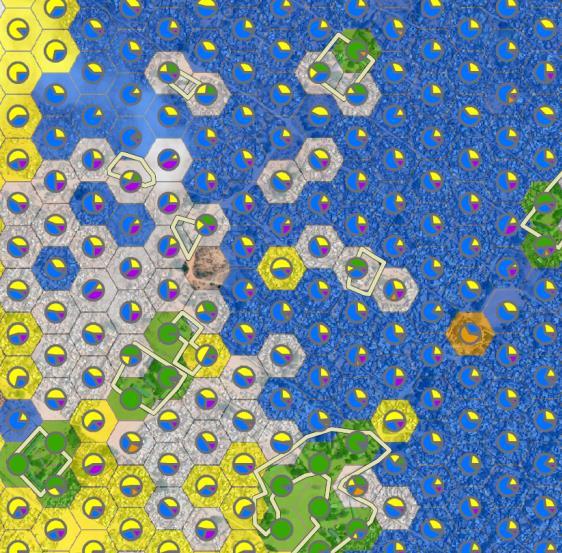
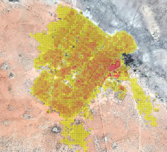
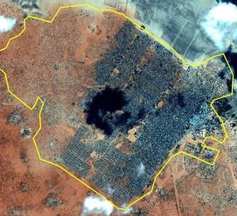
4 Population monitoring P. Füreder, Z_GIS, 5


 Semi-permanent")

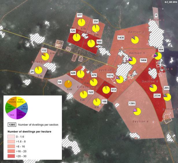
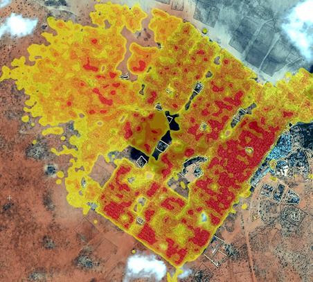
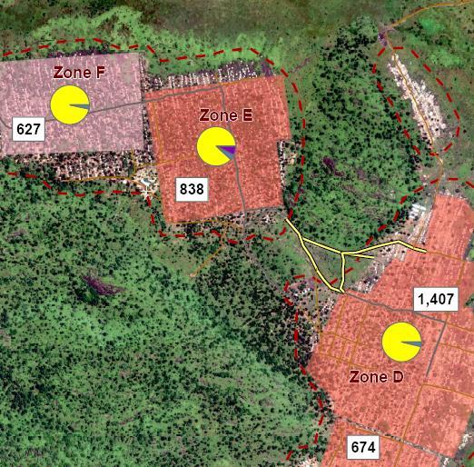
5 Population monitoring Amount and spatial distribution of different dwelling types in refugee/idp camps based on VHR satellite data Initial research started in 2006 Peter Biro/IRC 50 requests (~130 maps) in 12 countries since 2011, including regular monitoring Applied under various situations MSF not yet on site Camps in the setup phase (highly dynamic) Semi-permanent camps, but still spontaneous influx P. Füreder, Z_GIS, 6

6 P. Füreder, Z_GIS, DigitalGlobe 7

7 P. Füreder, Z_GIS, DigitalGlobe 8

8 P. Füreder, Z_GIS, DigitalGlobe 9

9 10 DigitalGlobe P. Füreder, Z_GIS,


 Brendan")


![[if available]](/docs-images/78/78424756/images/10-12.jpg "Object-based image")


")

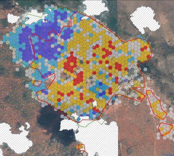
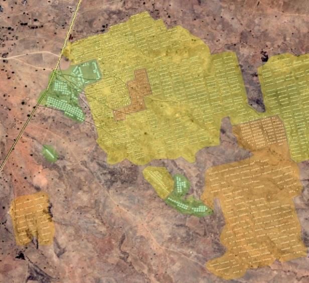
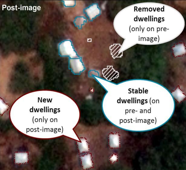
10 EO-based camp population monitoring User request Data integration Dwelling extraction (Multi-temporal) very highresolution satellite imagery (orthorectified, pansharpened) Brendan Bannon Sisay Zerihun, MSF Camp zoning, camp block information, camp infrastructure etc. [if available] Object-based image analysis (OBIA) different dwelling types Spatial analysis Dwelling density Camp outline Camp structure (e.g. based on distribution of different dwelling types) Distance analysis (e.g. amount of dwellings within a certain distance of latrines) Dwelling change (for multi-temporal data) Information delivery MAPS and DYNAMIC VISUALISATIONS Geospatial PDF maps Online mapping platform (here: ArcGIS online) Virtual globes (here: Google Earth) FIGURES and GRAPHS Integrated workflow for information delivery Up-to-date and custom-tailored information products P. Füreder, Z_GIS, petra.fuereder@sbg.ac.at 11

11 Automated dwelling extraction reduce work effort for large camps or monitoring tasks P. Füreder, Z_GIS, 12
12 Automated dwelling extraction Step 1: Segmentation P. Füreder, Z_GIS, 13
 P. Füreder, Z_GIS, petra.fuereder@sbg.ac.")
13 Automated dwelling extraction Step 2: Classification (shape, roof material, size) P. Füreder, Z_GIS, 14


14 Robustness and degree of automation Manual refinement! P. Füreder, Z_GIS, 15


15 Added value products P. Füreder, Z_GIS, 16

 VHR")


16 Population estimation in urban areas 3D built-up area LiDAR data Single buildings (average building footprint) VHR satellite image Storey height 16%: 1 family/storey 65%: 4-6 families/building 10%: no residential 9% : 1 family/building 40%: 1-2 persons/family 60%: 3.47 persons/family Exclusion areas (e.g. commercial buildings): OpenStreetMap Number of households per building Average family size P. Füreder, Z_GIS, petra.fuereder@sbg.ac.at 17

17 Groundwater exploration P. Füreder, Z_GIS, 18


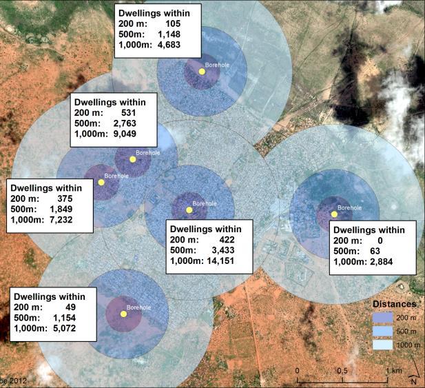
18 Groundwater exploration Aim: support drinking water supply in refugee/idp camps Remote sensing data analysis can provide information on local hydrogeology Close cooperation with field work essential cooperation with Hydrogeologists without Borders UK (HWB-UK) 7 requests in 7 countries at 15 sites, 52 maps Local satellite map Regional geology from existing maps Roads from OSM Local topography P. Füreder, Z_GIS, petra.fuereder@sbg.ac.at 19


19 Hydrogeological Mapping Digital Elevation Model Satellite Imagery Satellite-derived geological map Road network Available borehole data Available geological maps Hydrogeological Reconnaissance Map + Expert evaluation Benefits reduced field work overview to preexisting knowledge locations of potential drilling sites, or recommendations for further investigations P. Füreder, Z_GIS, petra.fuereder@sbg.ac.at 20

20 Environmental Impact Assessment P. Füreder, Z_GIS, 21


 2.")


21 Environmental Impact Assessment Multi-temporal HR/VHR optical satellite data 3-stage approach 1.stage: Vegetation mask (+ change) 2.stage: Detailed analysis of land use / land cover (+ change) 3.stage: Evaluation of impact on human well-being and ecosystem integrity Degree of automation Degree of expert input P. Füreder, Z_GIS, petra.fuereder@sbg.ac.at 22

.")
22 Thank you for your attention! Petra Füreder University of Salzburg Department of Geoinformatics - Z_GIS The presented work was co-funded by the FFG project EO4HumEn (contract no: ). Direct funding has been received by Médecins Sans Frontières (MSF) Austria and the Karl Kahane Foundation. P. Füreder, Z_GIS, petra.fuereder@sbg.ac.at 24
Platform and Products
 International Partnership Space Programme Earth Observation for the Preservation of Ecological Bacalar Corridor Platform and Products Terri Freemantle, Raffaella Guida, Paula Marti, Pasquale Iervolino
KKC can provide the total solution from Data capturing to Consulting
 Crowdsource Mapping Response to the Great East Japan Earthquake Kunihiro ISHII kunihiro_ishii@kk-grp.jp Business Fields of KOKUSAI KOGYO(KKC) KKC can provide the total solution from Data capturing to Consulting
EVALUATION OF DIFFERENT METHODS FOR GLACIER MAPPING USING LANDSAT TM
 EVALUATION OF DIFFERENT METHODS FOR GLACIER MAPPING USING LANDSAT TM Frank Paul Department of Geography, University of Zurich, Switzerland Winterthurer Strasse 190, 8057 Zürich E-mail: fpaul@geo.unizh.ch,
Remote Towers and the Digitalising of Middle Eastern & European ATM Infrastructure
 Remote Towers and the Digitalising of Middle Eastern & European ATM Infrastructure Mr Peter Hotham Deputy Executive Director ACI Exchange 2017 Muscat 6 December 2017 MAKING IT HAPPEN The Mission The Aviation
Hosted Flight Data Monitoring. Information Sheet
 17 Wellington Business Park Crowthorne Berkshire RG45 6LS England Tel: +44 (0) 1344 234047 www.flightdatapeople.com Hosted Flight Data Monitoring Information Sheet www.flightdatapeople.com Commercial in
COSMO-Coast. L Aquila. La Sapienza. Tor Vergata. Dipartimento di Architettura ed Urbanistica. Dipartimento di Informatica, Sistemi e Produzione,
 COSMO-Coast Tor Vergata Dipartimento di Informatica, Sistemi e Produzione, L Aquila Dipartimento di Architettura ed Urbanistica La Sapienza Dipartimento Ingegneria Civile, Edile ed Ambientale Introduction
Procedures of obtaining the exploitation permit for the utilization of geothermal energy
 Procedures of obtaining the exploitation permit for the utilization of geothermal energy Geothermal Energy in South-East Europe Stuttgart, 30 November 2009. Republic of Serbia - Ministry of Mining and
From AIS To AIM. Agenda. Agenda. Jack Hsu Mark Varellas
 Agenda Agenda From AIS To AIM 1. Introduction to MDA 2. What is AIS to AIM? 3. FAA Approach to AIM 4. AIM Transition Planning 5. ext Steps 1. Introduction to MDA 2. What is AIS to AIM? 3. FAA Approach
Integrated Applications Programme (IAP) & Space for UAS UAS for Applications
 & Space for UAS UAS for Applications") ESA s Integrated Applications Programme (IAP) & Space for UAS UAS for Applications M. Vaissiere ESA Director of Telecommunications and Integrated Applications Programme European High Level UAS Conference
ESA s Integrated Applications Programme (IAP) & Space for UAS UAS for Applications M. Vaissiere ESA Director of Telecommunications and Integrated Applications Programme European High Level UAS Conference
Egnatia Odos Observatory. Egnatia Odos Observatory Monitoring of Egnatia Motorway s s Spatial Impacts
 Egnatia Odos Observatory Egnatia Odos Observatory Monitoring of Egnatia Motorway s s Spatial Impacts 1 Egnatia Odos Observatory 1. The unique Greek observatory of transport and spatial impacts 2. Scope
AIXM Annual Conference 2008 Day 2 March 19 th (morning) Migration TO and FROM AIXM from other AMDB Formats. Alan Poole/Dejan Damjanovic
 Migration TO and FROM AIXM from other AMDB Formats. Alan Poole/Dejan Damjanovic") AIXM Annual Conference 2008 Day 2 March 19 th (morning) Migration TO and FROM AIXM from other AMDB Formats Alan Poole/Dejan Damjanovic Overview Background and Problem Definitions. IATA AIS Data Pool Vision.
AIXM Annual Conference 2008 Day 2 March 19 th (morning) Migration TO and FROM AIXM from other AMDB Formats Alan Poole/Dejan Damjanovic Overview Background and Problem Definitions. IATA AIS Data Pool Vision.
AIRPORTS GIS UPDATE. Federal Aviation Administration. https://airports-gis.faa.gov/
 AIRPORTS GIS UPDATE Presented to ACC Airports Technical Workshop Presented by John R. Dermody, Manager, Airport Engineering Division Date July 29, 2014 1 Airports GIS Update 1. AGIS Overview 2. NAV Lean
WASH ASSESSMENT REPORT LATRINE FACILITIES KUTUPALONG AND BALUKHALI MAKESHIFTS & SPONTANEOUS SETTLEMENTS IOM WASH UNIT, DECEMBER 2017
 WASH ASSESSMENT REPORT LATRINE FACILITIES KUTUPALONG AND BALUKHALI MAKESHIFTS & SPONTANEOUS SETTLEMENTS IOM WASH UNIT, DECEMBER 2017 INTRODUCTION The violence in Myanmar's Rakhine State which began on
Applying Geospatial Tools to Produce Data for SDG Indicators in Mexico
 Applying Geospatial Tools to Produce Data for SDG Indicators in Mexico Inter-Agency and Expert Group On SDGs Indicators Enrique Ordaz Francisco J. Jimenez Stockholm November 2018 Background INEGI has produced
A high resolution glacier model with debris effects in Bhutan Himalaya. Orie SASAKI Kanae Laboratory 2018/02/08 (Thu)
") A high resolution glacier model with debris effects in Bhutan Himalaya Orie SASAKI Kanae Laboratory 2018/02/08 (Thu) Research flow Multiple climate data at high elevations Precipitation, air temperature
A high resolution glacier model with debris effects in Bhutan Himalaya Orie SASAKI Kanae Laboratory 2018/02/08 (Thu) Research flow Multiple climate data at high elevations Precipitation, air temperature
UNMANNED AIRCRAFT SYSTEMS (UAS) IN UTILITIES
 IN UTILITIES") UNMANNED AIRCRAFT SYSTEMS (UAS) IN UTILITIES Presented by: Dan Carbone Avion Unmanned Why Drones? Why Drones? Cost Effective Entire cost of a UAS program can be recouped in first-year man-hour savings
UNMANNED AIRCRAFT SYSTEMS (UAS) IN UTILITIES Presented by: Dan Carbone Avion Unmanned Why Drones? Why Drones? Cost Effective Entire cost of a UAS program can be recouped in first-year man-hour savings
Robson Valley Avalanche Tract Mapping Project
 Robson Valley Avalanche Tract Mapping Project Prepared for: Chris Ritchie Ministry of Water Land and Air Protection 325 1011 4th Avenue Prince George, BC. V2L3H9 and Dale Seip Ministry of Forests 1011
The UNDP/GEF Danube Regional Project
 1 The UNDP/GEF Danube Regional Project Pilot River Basin Management Plan for the Sava River Sub-Basin Andy Garner Environmental Specialist Sava Initiative WG Meeting September 17-18, 2002 GEF Black Sea
USE OF 3D GIS IN ANALYSIS OF AIRSPACE OBSTRUCTIONS
 USE OF 3D GIS IN ANALYSIS OF AIRSPACE OBSTRUCTIONS A project by by Samuka D. W. F19/1461/2010 Supervisor; Dr D. N. Siriba 1 Background and Problem Statement The Airports in Kenya are the main link between
Committee. Presentation Outline
 CW-33-15 11/9/2015 Community and Corporate Services Committee November 10, 2015 1 Presentation Outline Background Vision and Objectives Study Process and Timeline Public and Stakeholder Engagement Organization
"ST. KLIMENT OHRIDSKI FACULTY OF GEOLOGY AND GEOGRAPHY
 SOFIA UNIVERSITY "ST. KLIMENT OHRIDSKI FACULTY OF GEOLOGY AND GEOGRAPHY APPLICATION OF THE MODEL "DRIVING FORCES PRESSURE STATE - RESPONSE FOR ASSESSMENT OF FLOOD RISK RADOSTINA BORISOVA DOCHEVA Bachelor
-News Release- September 7, 2011
 -News Release- September 7, 2011 KOKUSAI KOGYO to release first GIS-based Area Marketing Platform Service for Chinese Market Product supports corporate clients expanding in Chinese market by identifying
NEW WEB TOOL FOR UNDERSTANDING BIOLUMINESCENT BAYS
 NEW WEB TOOL FOR UNDERSTANDING BIOLUMINESCENT BAYS Fernando Gilbes Santaella* and William Hernandez GERS Lab-Department of Geology University of Puerto Rico at Mayaguez *fgilbes@uprm.edu RESEARCH COMPONENT
Retreating Glaciers of the Himalayas: A Case Study of Gangotri Glacier Using Satellite Images
 Retreating Glaciers of the Himalayas: A Case Study of Gangotri Glacier Using 1990-2009 Satellite Images Jennifer Ding Texas Academy of Mathematics and Science (TAMS) Mentor: Dr. Pinliang Dong Department
Preparedness and Rapid Response based on Geospatial Information at Great East Japan Earthquake in 2011
 Preparedness and Rapid Response based on Geospatial Information at Great East Japan Earthquake in 2011 Akira Doi Executive Officer Kokusai Kogyo Co., Ltd. Taken by Kokusai Kogyo UNISDR UNISDR is the United
Using LiDAR for Precise Vegetation Management
 Using LiDAR for Precise Vegetation Management Quantum Spatial is a proven partner to airport planners, engineers, facility managers, and contractors whose objective is to build, expand, and make improvements
5 Rail demand in Western Sydney
 5 Rail demand in Western Sydney About this chapter To better understand where new or enhanced rail services are needed, this chapter presents an overview of the existing and future demand on the rail network
NextGen Trajectory-Based Operations Status Update Environmental Working Group Operations Standing Committee
 NextGen Trajectory-Based Operations Status Update Environmental Working Group Operations Standing Committee May 17, 2010 Rose Ashford Rose.Ashford@nasa.gov 1 Outline Key Technical Concepts in TBO Current
Ohio UAS Center - Enabling Flight 2016 Ohio Planning Conference Fred Judson, GISP UAS Program Director
 Ohio UAS Center - Enabling Flight 2016 Ohio Planning Conference Fred Judson, GISP UAS Program Director Fred.Judson@dot.state.oh.us How It Began (For Me) Formalization of GIS in the district. Implementation
A-CDM AT HONG KONG INTERNATIONAL AIRPORT (HKIA)
") A-CDM AT HONG KONG INTERNATIONAL AIRPORT (HKIA) This document and the information contained herein is the property of Saab AB and must not be used, disclosed or altered without Saab AB prior written consent.
A-CDM AT HONG KONG INTERNATIONAL AIRPORT (HKIA) This document and the information contained herein is the property of Saab AB and must not be used, disclosed or altered without Saab AB prior written consent.
The SESAR Airport Concept
 Peter Eriksen The SESAR Airport Concept Peter Eriksen EUROCONTROL 1 The Future Airport Operations Concept 1.1 Airports The aim of the future airport concept is to facilitate the safe and efficient movement
Optimizing trajectories over the 4DWeatherCube
 Optimizing trajectories over the 4DWeatherCube Detailed Proposal - SES Awards 2016 Airbus Defence and Space : dirk.schindler@airbus.com Luciad : robin.houtmeyers@luciad.com Eumetnet : kamel.rebai@meteo.fr
STAIRWAY IDS ATC SIMULATION ENVIRONMENT - SWIM COMPATIBLE SYSTEM
 STAIRWAY IDS ATC SIMULATION ENVIRONMENT - SWIM COMPATIBLE SYSTEM Content The problem Simulation Platform Problem Statements The solution Use Case Application Description The benefits and next steps 2 IDS
Observations of glacier dynamics with PALSAR DATA
 Observations of glacier dynamics with PALSAR DATA Tazio Strozzi, Urs Wegmüller and Charles Werner Gamma Remote Sensing, Gümligen, Switzerland Rhodes, Greece, 3 to 7 November 2008 Outline ESA GLOBGLACIER
DriDanube. Drought Risk in the Danube Region. Department of Geodesy and Geoinformation (GEO) Vienna University of Technology (TU Wien)
 Vienna University of Technology (TU Wien)") DriDanube Drought Risk in the Danube Region Department of Geodesy and Geoinformation (GEO) Vienna University of Technology (TU Wien) Vienna, 4 April 2018 DriDanube Drought Risk in the Danube Region Project
DriDanube Drought Risk in the Danube Region Department of Geodesy and Geoinformation (GEO) Vienna University of Technology (TU Wien) Vienna, 4 April 2018 DriDanube Drought Risk in the Danube Region Project
ACTION PLAN FOR THE PERIOD concerning the STRATEGY ON IMPLEMENTATION OF THE FRAMEWORK AGREEMENT ON THE SAVA RIVER BASIN
 Doc. 1S-26-O-11-5/1-2 ACTION PLAN FOR THE PERIOD 2011-2015 concerning the STRATEGY ON IMPLEMENTATION OF THE FRAMEWORK AGREEMENT ON THE SAVA RIVER BASIN April 2011 Table of Contents INTRODUCTION... 5 1.
Tourism and Natura DI Thomas Knoll Knoll Planung & Beratung Vienna, Austria
 Cyprus 30/05/2006 Tourism and Natura 2000 DI Thomas Knoll Knoll Planung & Beratung Vienna, Austria The situation in the alpine region A very high number and diversity of endangered and rare species High
Remote towers at your service. First validation of remote tower for multiple airports (PJ05)
") Remote towers at your service First validation of remote tower for multiple airports (PJ05) DLR (AT-One) the research perspective Remote Tower Operations from Vision to Reality Proof of Concept Since 2008
Remote towers at your service First validation of remote tower for multiple airports (PJ05) DLR (AT-One) the research perspective Remote Tower Operations from Vision to Reality Proof of Concept Since 2008
Proposed Peninsula Bay Bike Track Development
 Proposed Peninsula Bay Bike Track Development May 2018 BACKGROUND The area of land at the northern extreme of Wanaka's Peninsula Bay development (Lot 923 DP 501325), currently owned by Infinity Investment
SATELLITE CAPACITY DIMENSIONING FOR IN-FLIGHT INTERNET SERVICES IN THE NORTH ATLANTIC REGION
 SATELLITE CAPACITY DIMENSIONING FOR IN-FLIGHT INTERNET SERVICES IN THE NORTH ATLANTIC REGION Lorenzo Battaglia, EADS Astrium Navigation & Constellations, Munich, Germany Lorenzo.Battaglia@Astrium.EADS.net
Validation Plan & Objectives. Maik Friedrich, DLR PJ05 Braunschweig, 22 of November 2017
 Validation Plan & Objectives Maik Friedrich, DLR PJ05 Braunschweig, 22 of November 2017 Validation Plan Overview of Remote Tower Activities in SESAR 2020 2 Remote Tower PJ.05 DLR (AT-One) Remotely Provided
Regional implementation of Electronic Terrain and Obstacle data (e-tod) (Presented by Jeppesen)
 (Presented by Jeppesen)") International Civil Aviation Organization SAM/IG/13-WP/39 South American Regional Office 5/04/14 Thirteenth Workshop/Meeting of the SAM Implementation Group English only (SAM/IG/13) - Regional Project
International Civil Aviation Organization SAM/IG/13-WP/39 South American Regional Office 5/04/14 Thirteenth Workshop/Meeting of the SAM Implementation Group English only (SAM/IG/13) - Regional Project
IAC 2011 Cape Town, October th
 Cape Town, October 05 05 th Project Partners External Supporters and Sponsors The Problem The Solution Overview S 2 BAS Concept of Operations Architecture Possible Applications Stakeholders Flight Phases
SUPPORT TO WATER RESOURCES MANAGEMENT IN THE DRINA RIVER BASIN DRAFT ROOF REPORT INTRODUCTION AND GENERAL APPROACH
 SUPPORT TO WATER RESOURCES MANAGEMENT IN THE DRINA RIVER BASIN DRAFT ROOF REPORT INTRODUCTION AND GENERAL APPROACH Nadja Zeleznik, REC Public Concultation Beograd, Serbia, 4 July 2017 1 1. Introduction
agis a brief overview
 agis a brief overview Steve Welebny Photogrammetrist Keystone Aerial Surveys Villanova University 1 Villanova University 2 Nav Aid Cost VOR Install = $250,000 20 year life cycle cost = $1,100,000 ILS Install
First Steps Towards Sustainable Operation of Road Tunnels. George Mavroyeni Australia
 First Steps Towards Sustainable Operation of Road Tunnels George Mavroyeni Australia Road Tunnel Operations First steps towards sustainable operation of road tunnels Available on PIARC website here PIARC
Passenger Dwell Time Analysis at Copenhagen Airport
 Passenger Dwell Time Analysis at Copenhagen Airport Esben Kolind, Senior Business Analyst, Copenhagen Airports Kevin O'Sullivan Lead Engineer, SITA Lab Agenda About Copenhagen Airports and SITA Lab Using
Ground Deformation Monitoring at Natural Gas Production Sites using Interferometric SAR
 Ground Deformation Monitoring at Natural Gas Production Sites using Interferometric SAR By: Kanika Goel, Robert Shau, Fernando Rodriguez Gonzalez, Nico Adam Remote Sensing Technology Institute (IMF), German
LinkingSEEA & TSA towards a statistical framework for sustainable tourism
 LinkingSEEA & TSA towards a statistical framework for sustainable tourism UNCEEA Meeting22 June 2016 UNWTO Statistics and TSA Programme Measuring Sustainable Tourism (MST) UNSD/UNWTO initiated programme
If there is magic on this planet, it is contained in water.
 If there is magic on this planet, it is contained in water. Loren Eiseley ~ American philosopher and nature writer ~ b.1907 d.1977 Above: A swimmer rests in the X Keken Cenote underground pool in the town
Training for Manual Flying Skills
 EATS 2012 Training for Manual Flying Skills Presented by Capt. Jacques Drappier ACCIDENT RATES IATA Figures 2011 ICAO STATISTICS LOC-I = Loss of Control in flight AIRBUS Hull Loss Accidents end 2011 50
EO Contribution to Recovery Activities - A case study on the experience of the Great East Japan Earthquake -
 EO Contribution to Recovery Activities - A case study on the experience of the Great East Japan Earthquake - Michio Ito (Mr.) ito.michio@jaxa.jp Space Applications and Operation Center JAXA Purpose of
Land Figures & Spatial Data Infrastructure in KOSOVO
 Land Figures & Spatial Data Infrastructure in KOSOVO Idriz SHALA idriz.shala@gmail.com GIS -expert Afrim SHARKU afrim.sharku@gmail.com Land Management - Expert Kick-off meeting of the Regional Expert Advisory
CONNECT Events: Flight Optimization
 CONNECT Events: Flight Optimization Ian Britchford Director Post Flight Solutions 5 th October 2016 Data Analysis and Root Cause Evaluation for Continuous Improvement Learn about Jeppesen s next level
MIDAD Project IDS Vision
 MIDAD Project IDS Vision Cairo July, 2013 Ramy El-Jabi Outline MIDAD Scope Solution High Level Architecture IDS Air Navigation Suite Proposed Implementation Schedule 2 MIDAD Scope Drawbacks related to
Nature Conservation Agency (NCA) Salacgrīva 05/07/2018
 Salacgrīva 05/07/2018") Nature Conservation Agency (NCA) Salacgrīva 05/07/2018 Nature Conservation Agency ensures implementation of unified nature protection policy in Latvia Specially protected nature areas in Latvia Specially
Nature Conservation Agency (NCA) Salacgrīva 05/07/2018 Nature Conservation Agency ensures implementation of unified nature protection policy in Latvia Specially protected nature areas in Latvia Specially
Needs for UAS in Response
 UAS Potential Uses and Limitations October 21, 2015 Michele Jacobi Office Response and Restoration 10/27/2015 1 Needs for UAS in Response Limited access to areas of interest (distance, safety concerns,
Glacial lakes as sentinels of climate change in Central Himalaya, Nepal
 Glacial lakes as sentinels of climate change in Central Himalaya, Nepal Sudeep Thakuri 1,2,3, Franco Salerno 1,3, Claudio Smiraglia 2,3, Carlo D Agata 2,3, Gaetano Viviano 1,3, Emanuela C. Manfredi 1,3,
Spectral Efficient COMmunications for future Aeronautical Services. Jan Erik Håkegård ICT
 Spectral Efficient COMmunications for future Aeronautical Services Jan Erik Håkegård 1 Outline Overview aeronautical communication today International activities SECOMAS activities Impact on Norwegian
GEOSPATIAL ANALYSIS OF GLACIAL HAZARDS PRONE AREAS OF SHIGAR AND SHAYOK BASINS OF PAKISTAN. By Syed Naseem Abbas Gilany
 GEOSPATIAL ANALYSIS OF GLACIAL HAZARDS PRONE AREAS OF SHIGAR AND SHAYOK BASINS OF PAKISTAN By Syed Naseem Abbas Gilany PRESENTATION OUTLINE Introduction Problem Statement / Rationale Objectives Material
IAGSA Survey Contract Annex
 Notice to Users This document will be expanded and revised from time to time without notice. Users may obtain the most current version from IAGSA s web site at: www.iagsa.ca The Safety Policy Manual referred
Benton County Karstic Mapping Project. Barbara France, Dustin Kochen, Tiffany Clark, John Maloney Paul Lowery's Environmental Geology
 Benton County Karstic Mapping Project Barbara France, Dustin Kochen, Tiffany Clark, John Maloney Paul Lowery's Environmental Geology Intro Karst refers to an area of bedrock that is very susceptible to
Context Scope Procurement approach Topics for discussions Timeline. EDA/ESA UAS Workshop May
 Upcoming feasibility studies Context Scope Procurement approach Topics for discussions Timeline EDA/ESA UAS Workshop May 2009 1 Context now 2 Satellite-UAS cooperative missions study Letter of Exchange
Federal GIS Conference February 10 11, 2014 Washington DC. ArcGIS for Aviation. David Wickliffe
 Federal GIS Conference 2014 February 10 11, 2014 Washington DC ArcGIS for Aviation David Wickliffe What is ArcGIS for Aviation? Part of a complete system for managing data, products, workflows, and quality
The Pitcairn Islands The world s largest fully protected marine reserve
 A fact sheet from March 2015 The Pitcairn Islands The world s largest fully protected marine reserve Overview In March 2015, the United Kingdom declared the world s largest fully protected marine reserve
Capacity Building Programme on Tourism Statistics Workshop IV Vienna (AT), 18-20/11/2009
, 18-20/11/2009") Capacity Building Programme on Tourism Statistics 2008-2009 Workshop IV Vienna (AT), 18-20/11/2009 Revised classification framework for types of accommodation & 2010-2012 project on automated data collection
Capacity Building Programme on Tourism Statistics 2008-2009 Workshop IV Vienna (AT), 18-20/11/2009 Revised classification framework for types of accommodation & 2010-2012 project on automated data collection
MONITORING OF LAKE NASSER USING REMOTE SENSING AND GIS TECHNIQUES
 MONITORING OF LAKE NASSER USING REMOTE SENSING AND GIS TECHNIQUES M. M. Mostafa a and H. K. Soussa b a Information Technology Institute, GIS department - mostafam@mcit.gov.eg b Ain Shams University, Faculty
FLIGHT PATH FOR THE FUTURE OF MOBILITY
 FLIGHT PATH FOR THE FUTURE OF MOBILITY Building the flight path for the future of mobility takes more than imagination. Success relies on the proven ability to transform vision into reality for the betterment
AUTHORITATIVE AIRPORT DATA FOR CRITICAL FLIGHT SAFETY AND AUTOMATED SITUATIONAL AWARENESS MEETS FAA (USA) AND ICAO (INT'L) REQUIREMENTS
 AND ICAO (INT'L) REQUIREMENTS") AUTHORITATIVE AIRPORT DATA FOR CRITICAL FLIGHT SAFETY AND AUTOMATED SITUATIONAL AWARENESS MEETS FAA (USA) AND ICAO (INT'L) REQUIREMENTS H. Howard a, P. Hummel b a CompassData, Inc, Centennial, Colorado,
AUTHORITATIVE AIRPORT DATA FOR CRITICAL FLIGHT SAFETY AND AUTOMATED SITUATIONAL AWARENESS MEETS FAA (USA) AND ICAO (INT'L) REQUIREMENTS H. Howard a, P. Hummel b a CompassData, Inc, Centennial, Colorado,
Driving STM32 to success STM32 services for sophisticated embedded applications
 Building a safe and secure embedded world Driving STM32 to success STM32 services for sophisticated embedded applications > STM32 Services HITEX: the stm32 experts Questions about STM32? Ask us! STM32
KEY FEATURES IN SHORT
 KA C90/B200/350 KA C90/B200/350 It is the fixed base simulator of commercial turboprop multi-crew aircraft. The simulator meets all the requirements determined for EASA CS-FSTD(A) FNPTII +MCC level. The
A Survey of Time and Space Partitioning for Space Avionics
 2018-05-25, 21:52:13 A Survey of Time and Space Partitioning for Space Avionics Presentation at DASIA 2018 31st May 2018 The Basic Idea of TSP Motivation Time and Space Partitioning (TSP) Why? several
Sustaining quality of services through service reliability and availability
 Sustaining quality of services through service reliability and availability Karthikh Pandian, Chinnathurai Cognizant Technology Solutions Karthikh.pandian@cognizant.com January-4-17 ASTR 2016, Sep 9-11,
PROTECTED AIRSPACE ASSESSMENT TOOL (PAAT) USER MANUAL
 USER MANUAL") PROTECTED AIRSPACE ASSESSMENT TOOL (PAAT) USER MANUAL March 2016 TABLE OF CONTENTS 1.0 INTRODUCTION 1 2.0 STATUTORY APPROVALS PROCESS 2 2.1 PRESCRIBED AIRSPACE 2 2.2 PERTH AIRPORT ASSESSMENT PROCESS 3
PROTECTED AIRSPACE ASSESSMENT TOOL (PAAT) USER MANUAL March 2016 TABLE OF CONTENTS 1.0 INTRODUCTION 1 2.0 STATUTORY APPROVALS PROCESS 2 2.1 PRESCRIBED AIRSPACE 2 2.2 PERTH AIRPORT ASSESSMENT PROCESS 3
FLL Master Plan Update BOARD OF COUNTY COMMISSIONERS BRIEFING
 (PRELIMINARY DRAFT) WORK IN PROGRESS - FOR DISCUSSION PURPOSES ONLY FLL Master Plan Update BOARD OF COUNTY COMMISSIONERS BRIEFING May 15, 2018 Master Plan Schedule Overview Progress Since Last Master Plan
City of Manassas Park
 Presented to: City of Manassas Park November 15, 2005 Overview of Presentation Background of Park Center Manassas Park Team Overview of Clark Realty What is Park Center? Master Plan Development Schedule
Development of New Types of Glacier Dynamics Maps
 Development of New Types of Glacier Dynamics Maps Manfred F. Buchroithner, Sebastian Walther, Klaus Habermann TU Dresden Institute for Cartography Background The Project OMEGA Measurement of Glacier Movements
Collaboration for best Passenger Experience Check-In of the Future Enhancing the Passenger Experience
 Collaboration for best Passenger Experience Check-In of the Future Enhancing the Passenger Experience Presentation at the 23 rd ACI Africa Region Annual Conference 14 th October 2014, Durban by Torsten
Seminar on USOAP Continuous Monitoring Approach (CMA) and State Aviation Safety Tools (SAST)
 and State Aviation Safety Tools (SAST)") International Civil Aviation Organization Seminar on USOAP Continuous Monitoring Approach (CMA) and State Aviation Safety Tools (SAST) ICAO Electronic Safety Tools Module 10 1 Contents 9.1 Introduction
International Civil Aviation Organization Seminar on USOAP Continuous Monitoring Approach (CMA) and State Aviation Safety Tools (SAST) ICAO Electronic Safety Tools Module 10 1 Contents 9.1 Introduction
Terms of Reference (ToR) for a Short-Term assignment
 for a Short-Term assignment") Terms of Reference (ToR) for a Short-Term assignment Technical assistance requested Expert for climate change mitigation and adaptation Project Title Outline of the Climate Adaptation Strategy and basin-wide
Terms of Reference (ToR) for a Short-Term assignment Technical assistance requested Expert for climate change mitigation and adaptation Project Title Outline of the Climate Adaptation Strategy and basin-wide
lastminute.com Group Milan November 2018
 lastminute.com Group Milan November 2018 lastminute.com Group Overview A journey of growth and diversification addressed to long-term value maximisation 4 We have a global footprint Context lmn group
NETLIPSE Infrastructure Project Assessment Tool
 NETLIPSE Infrastructure Project Assessment Tool Stuart Baker, Deputy Director of National Rail Projects Department for Transport, UK Vienna, September 28, 2010 Contents 1. Refinement of IPAT 2. IPAT Assessment
SCRAMJET. Mapping and monitoring airports with Sentinel 1 and 2 data
 SCRAMJET Mapping and monitoring airports with Sentinel 1 and 2 data 18/03/2018 GISTAM 2018 Urban geospatial mapping for the SCRAMJET business networking tool Nuno Duro, Pedro Coutinho, Gil Gonçalves Index
PROSPECTS FOR IN-FLIGHT ENTERTAINMENT & CONNECTIVITY
 2017 BROCHURE PROSPECTS FOR IN-FLIGHT ENTERTAINMENT & CONNECTIVITY FORECASTS TO 2026 5 th Edition A Euroconsult Executive Report Sector dynamics, analysis and forecasts addressing the IFEC market for commercial
Garapuà beach. Eco-Tourism Project. Morro de San Paolo - Bahía Nord Est del Brasile
 Garapuà beach Eco-Tourism Project Morro de San Paolo - Bahía Nord Est del Brasile INDEX 1) MORRO SAO PAOLO - Introduction 2) TAMACA - Location 3) TAMACA Phases of the project of urban development 4) TAMACA
THE DEVELOPMENT OF LUXOR OPEN AIR MUSUEM AND ITS SOCIAL IMPACTS AN ASSESSMENT USING GEOGRAPHIC INFORMATION SYSTEMS. Thesis submitted for the degree of
 THE DEVELOPMENT OF LUXOR OPEN AIR MUSUEM AND ITS SOCIAL IMPACTS AN ASSESSMENT USING GEOGRAPHIC INFORMATION SYSTEMS Thesis submitted for the degree of Doctor of Philosophy at the University of Leicester
Curriculum Vitae (C.V.) Ahmed Abdel-Halim Ahmed Mohamed
 Ahmed Abdel-Halim Ahmed Mohamed") Permanent Address Department of Geology, Faculty of Science, Assiut University, Assiut 71516, Egypt Tel: 0020 88 2 41 21 89 Fax: 0020 88 2 342 708 Cell: 0020 10 83 90 135 ahmed41982@yahoo.com Personal
Permanent Address Department of Geology, Faculty of Science, Assiut University, Assiut 71516, Egypt Tel: 0020 88 2 41 21 89 Fax: 0020 88 2 342 708 Cell: 0020 10 83 90 135 ahmed41982@yahoo.com Personal
Geospatial Data Collection for the FAA Airports GIS Program
 Geospatial Data Collection for the FAA Airports GIS Program A Change in Direction Dr. Michael T. McNerney, P.E. FAA Office of Airports Office of Airport Safety and Standards Assistant Manager, Airport
A SEGMENTED ARCHITECTURE APPROACH TO PROVIDE A CONTINUOUS, LONG-TERM, ADAPTIVE AND COST- EFFECTIVE GLACIERS MONITORING SYSTEM
 1st IAA Latin American Symposium on Small Satellites: Advanced Technologies and Distributed Systems A SEGMENTED ARCHITECTURE APPROACH TO PROVIDE A CONTINUOUS, LONG-TERM, ADAPTIVE AND COST- EFFECTIVE GLACIERS
Revenue Management in a Volatile Marketplace. Tom Bacon Revenue Optimization. Lessons from the field. (with a thank you to Himanshu Jain, ICFI)
") Revenue Management in a Volatile Marketplace Lessons from the field Tom Bacon Revenue Optimization (with a thank you to Himanshu Jain, ICFI) Eyefortravel TDS Conference Singapore, May 2013 0 Outline Objectives
Revenue Management in a Volatile Marketplace Lessons from the field Tom Bacon Revenue Optimization (with a thank you to Himanshu Jain, ICFI) Eyefortravel TDS Conference Singapore, May 2013 0 Outline Objectives
Spatio-temporal Data Analysis and Visualization in Enterprise Level Automated Application
 Spatio-temporal Data Analysis and Visualization in Enterprise Level Automated Application Sept 29 - Oct 1, 2015 Kualal Lumpur Shyam Parhi Washington DC What is driving Airports GIS? Reduce costs to Airports,
Visit of Chinese representatives of the International Research Centre for Karst (IRCK) to the CKH
 to the CKH") Visit of Chinese representatives of the International Research Centre for Karst (IRCK) to the CKH The International Research Center on Karst (IRCK) was formed in 2008 in Guilin, China under the Auspices
Visit of Chinese representatives of the International Research Centre for Karst (IRCK) to the CKH The International Research Center on Karst (IRCK) was formed in 2008 in Guilin, China under the Auspices
MODAIR. Measure and development of intermodality at AIRport
 MODAIR Measure and development of intermodality at AIRport M3SYSTEM ANA ENAC GISMEDIA Eurocontrol CARE INO II programme Airports are, by nature, interchange nodes, with connections at least to the road
Engineering With Nature Geographic Project Mapping Tool (EWN ProMap)
") Engineering With Nature Geographic Project Mapping Tool (EWN ProMap) Cynthia Banks Program Manager Burton Suedel, PhD Research Biologist Michelle Bourne Research Biologist U.S. Army ERDC 23 June 2015 Dredging
Engineering With Nature Geographic Project Mapping Tool (EWN ProMap) Cynthia Banks Program Manager Burton Suedel, PhD Research Biologist Michelle Bourne Research Biologist U.S. Army ERDC 23 June 2015 Dredging
HELLENIC REPUBLIC Voluntary National Review on the Implementation of the 2030 Agenda for Sustainable Development. 16 July 2018
 HELLENIC REPUBLIC Voluntary National Review on the Implementation of the 2030 Agenda for Sustainable Development 16 July 2018 1 HELLENIC REPUBLIC Voluntary National Review on the Implementation of the
Transport of Biomass on the Danube River. Bettina Matzner, viadonau 24 June 2014, JRC Danube Bioenergy Nexus Workshop
 Transport of Biomass on the Danube River Bettina Matzner, viadonau 24 June 2014, JRC Danube Bioenergy Nexus Workshop via donau is Established and owned by the Austrian Federal Ministry for Transport, Innovation
The Skyward Platform Helps You Manage UAV Operations
 The Skyward Platform Helps You Manage UAV Operations About Skyward Skyward s cloud-based UAV management platform powers scalable, efficient, safe, and insurable UAV operations for small businesses and
SANBI PLANNING FORUM
 SANBI PLANNING FORUM SPATIAL PLANNING IN PROTECTED AREAS AND THEIR BUFFERS (South Africa) Ms Jayshree Govender, Dr Mike Knight and Mr Russell Smart 22 June 2017 OUTLINE 1) Introduction 2) Protected areas
ETOBICOKE CREEK NORTH TRAIL PROJECT. May 18, 2017 at Michael Power High School 105 Eringate Drive, Etobicoke ON M9C 3Z7
 ETOBICOKE CREEK NORTH TRAIL PROJECT May 18, 2017 at Michael Power High School 105 Eringate Drive, Etobicoke ON M9C 3Z7 1 Purpose of Open House The purpose of today s open house is to present the design
USING ECOGNITION TO AUTOMATICALLY DETECT AND MAP AVALANCHE DEPOSITS FROM THE SPRING 2009 AVALANCHE CYCLE IN THE TATRA MTS.
 USING ECOGNITION TO AUTOMATICALLY DETECT AND MAP AVALANCHE DEPOSITS FROM THE SPRING 2009 AVALANCHE CYCLE IN THE TATRA MTS., SLOVAKIA R. Frauenfelder a, 0F*, M. J. Lato b, M. Biskupič c,d a Norwegian Geotechnical