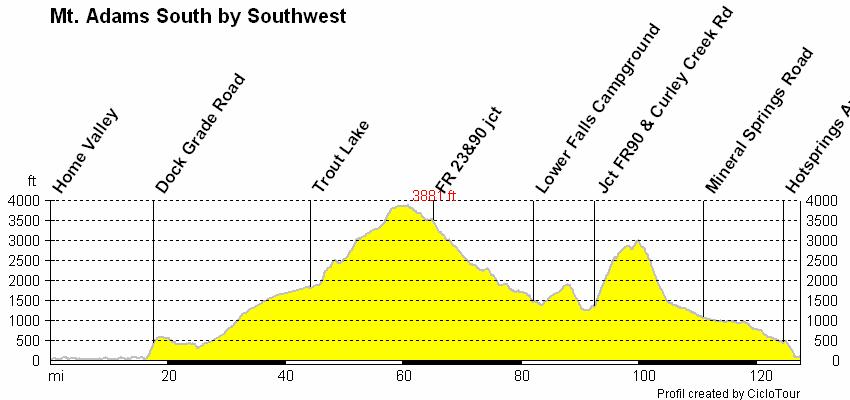
June 17 th John Kramer Distance miles, Elevation Gain 7500 ft, Very little traffic but there may be more as July recreation picks up.
|
|
|
- Juliana Allison
- 5 years ago
- Views:
Transcription
1 Preride Route Notes June 17 th John Kramer Distance miles, Elevation Gain 7500 ft, Very little traffic but there may be more as July recreation picks up. Home Valley to Bingen The start time is early, 06:00 to avoid traffic on Highway 14. There are several pinch points on the route where there is no shoulder to ride. The worst is a one mile section starting at mile Not a good place to stop for pictures. Bingen to Trout Lake There is a nice warm up hill between Bingen and White Salmon starting at mile Stay on SR 141 through White Salmon. The State Highway Department put a rumble strip on the fog line leaving town. They did this to protect the users of the city loop trail from encroaching motor vehicles. Recommend staying on the road and avoid the trail as the trail has two way traffic and is not wide enough. The route leaves SR141 at mile 36 or SR141 mp Watch for the Sunnyside road sign. Don t forget the control question at the Glenwood turn. You can find restrooms at the gas station and restaurant in Trout Lake. There is also good water and restrooms/showers at the county park. There is a map to the county park in the ride packet. Fill water as this is the last chance for almost 40 miles. Trout Lake to Lower Falls Campground Nice ride though the woods and a nice view of Mt. Adams. Route climbs to over 3800 feet. Smooth road surface. Most recreation sites appeared to be closed. There are some nice views of the Lewis River at the Middle Falls if you want to take a break. Watch for the sign. Lower Falls to Wind River Road The road surface is breaking up in spots so watch for bumps and pot holes. This section includes Curly Creek road. The first three miles are the steepest (average grade 7.5%) and the grade mellows to 3% at mile 4. You can get a good view of Mount St. Helens at or near the McClellen view point. At mile 5 you turn right on Wind River road where the grade is one or two percent to Old Man Pass where the downhill starts. Nice downhill! Wind River Road to Home Valley There is more traffic on Mineral Springs road but traffic was light during this ride. There are no road shoulders other than the fog line. There are only several short inclines on the way to Carson. There was a small store open at Stabler which would be the first business in about 70 miles. At Carson, turn left at the stop sign. The mosquitoes were bad at the park, perhaps because of recent rain. I don t recall mosquitoes being a problem in the past when I have visited the park. If they are bad during the ride, riders may recuperate at one of restaurants in Stevenson. There are no services left at Home Valley.
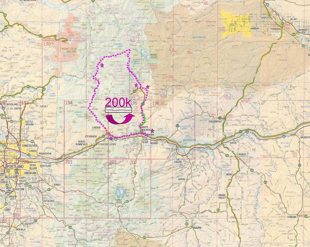
2 Beach/Picnic are parking lot (next to rest rooms) Start Control: 1 opens: JUL-15 05: R SR S Caution! 5 Tunnels next 2.5 miles S Stay on SR 14 (pass SR 141a junction) L SR 141 (To Trout Lake) Control: 2 Answer Question on Card: S Stay on 141 (jct 141a) R onto Sunnyside Rd (~mp 19.2) R Stay on Sunnyside Road (Warner Rd to left) L Stay on Sunnyside Road (Latimer Rd to right) L Trout Lake Glenwood Rd (a.k.a Sunnyside Road) Control: 3 Answer Question on Card: L Mt. Adams Rd (to Trout Lake) R SR 141 (Through Trout Lake) TA Trout Lake Store (Restrooms at gas station or County Park) Control: 4 Answer Question on Card R Return to L Mt. Adams Rd (to South Climb) BL FR 23 (to Randle) S Stay on FR 23 past jct. Pacific Crest Trail BL Left onto FR 90 Lewis River (elev 3650) S Stay on FR 90 past jct FR S Caution: Gravel Bump L Lower Falls Campground (road 9054) L Water Stop in Upper Loop (Water pump on right) Control: 5 Answer Question on Card: R Finish upper Loop and back onto FR L Back onto FR 90 (Lewis River Road) S Caution! Dirt rd (washout) S Pavement resumes BL Stay on FR L Curley Creek Rd R Wind River Rd L Stay on Wind River Road (Mineral Springs Rd to right) L Hotsprings Ave. to SR 14 East L SR 14 (Cross Wind River) R Turn to Home Valley Park Parking Lot (Showers in Park building next to beach) 0.2 End Control: 6 opens: JUL-15 10:53 closes: JUL-15 18:30
3
4
5
 Post Office County Park Trout Lake")
6 County Park in Trout Lake Restrooms, Water, Showers and Camping Brevet Route (mile 44 Trout Lake) Post Office County Park Trout Lake Store
7 Oregon Cascade Locks Bridge of the Gods Motel & RV Park 630 Wanapa Street Cascade Locks, OR Best Western Columbia River Inn 735 Wanapa Street Cascade Locks OR Hood River / Mosier Hood River BnB 918 Oak St Hood River, OR , Telephone Mosier House Bed & Breakfast 704 Third Ave. Mosier, OR , Toll Free Vagabond Lodge 4070 Westcliff Drive Hood River OR USA Meredith Motel 4300 Wescliff Drive Prater s Motel 1306 Oak Ave Riverview Lodge 1505 Oak St. Hood River OR USA Best Western Hood River Inn 1108 East Marina Way Hood River OR USA Comfort Suites 2625 Cascade Ave Hood River OR USA The Dalles Columbia Windrider Inn 200 West Fourth Street The Dalles, OR (541) Motel W 6 th St. The Dalles, OR Cousins County Inn 2114 West 6th The Dalles OR USA Super 8 Motel 609 Cherry Heights Road The Dalles OR Comfort Inn 351 Lone Pine Drive The Dalles OR USA
8 Washington Stevenson/Carson/Home Valley Wind Mountain Resort, Highway 14. Home Valley / Stevenson, WA (509) Columbia Gorge Riverside Lodge PO Box 381 Stevenson Washington Toll Free Carson Mineral Hot Springs Resort 372 St. Martin's Springs Road, Carson, Washington (509) Sandhill Cottages, 932 Hot Springs Ave Carson WA, , Econo Lodge Stevenson 40 NE 2nd St, Stevenson, WA (509) Bingen / Lyle WA Bingen Haus, Bingen WA (509) The Columbia River Gorge Hostel The corner of Humboldt and Cedar Bingen, WA Phone (509) The Lyle Hotel 100 Seventh Street Lyle WA
Additional Economic Development Strategy submissions- Klickitat County
 Klickitat County Transportation Improvement Projects 1 White Salmon to Hood River Bridge Final EIS, design, bridge replacement 2 Klickitat County Rural Arterials Reconstruct to all-weather roads Part of
Gorgeous Relay Driving Directions September 16, 2018
 2018 Gorgeous Relay Legs 1-3 Gorgeous Relay Start: Mark O. Hatfield Trailhead, Mosier Take I-84 to Exit 69, Mosier. Follow the brown signs for the Historic Columbia River Hwy State Trail. The Start Line
Trailhead Ambassadors 2018 Starvation Creek: Alternative Hikes
 Trailhead Ambassadors 2018 Starvation Creek: Alternative Hikes Starvation Creek Summary Near the Trailhead: o Starvation Creek Falls. Just a short walk to the east. o Loop trail to Cabin Creek Falls, Hole-in-the-Wall
Oregon Section G - Page 1
 21 N. 20 N. 19 N. 599000m 600000m 601000m Oregon Section G - Page 1 602000m 603000m 604000m Oregon Section G - 55.2 miles Start - Hwy 35, mile 2091.7 [near Barlow Pass] End - Cascade Locks, mile 2146.9
HOT LAVA Hood River, OR. Mt. Hood Miata Club. HOOD RIVER, OREGON Sept ACTIVITIES
 HOT LAVA 2017 Hood River, OR Mt. Hood Miata Club HOOD RIVER, OREGON Sept. 14-17 2017 ACTIVITIES WELCOME! Hot Lava 2017 Schedule Schedule of Events September 14-17 Thursday 9/14 1:00 to 4:00 pm Early Bird
Trailhead Ambassadors 2018 Latourell Falls: Alternative Hikes
 Trailhead Ambassadors 2018 Latourell Falls: Alternative Hikes General Note: The Historic Highway is closed from the Bridal Veil exit to its eastern end near Wyeth i.e., the Waterfall Alley section. The
WIND RIVER PUBLISHING, LLC
 2016 Skamania County Visitors Guide Media Kit: page 2 Columbia River Gorge Media Kit: pages 3-7 Judy Bair -:- Wind River Publishing, LLC 541-806-1436 -:- judywrpub@earthlink.net www.windriverpublishing.net
Race Booklet
 Race Booklet www.gorgeousseries.com GORGEOUS RUNNER REWARDS! 5% off a 2 nd relay in 2018 10% off a 3 rd 20% off a 4 th and 30% off your 5 th relay in 2018! Saturday, May 19 Gorgeous Portland Pub Relay
MT. H O O D & T H E G O R G E T O U R I S M L I S T E N I N G S E S S I O N O V E R V I E W
 Oregon Tourism Listening Session Summary June 2018 T O U R I S M L I S T E N I N G S E S S I O N O V E R V I E W Travel Oregon, in partnership with the Mt. Hood Territory, hosted an Oregon Tourism Listening
National Scenic Byways Program US Department of Transportation
 1 2 National Scenic Byways Program US Department of Transportation Abstract The Cowlitz-Wahkiakum Council of Governments in partnership with Cowlitz, Skamania and Lewis Counties and the U.S. Forest Service,
WIND RIVER PUBLISHING, LLC
 2019 Columbia River Gorge To Mt. Hood Media Kit: pages 2-6 Skamania County Visitors Guide Media Kit: page 7 WIND RIVER PUBLISHING, LLC Judy Bair -:- Wind River Publishing, LLC 541-806-1436 -:- windriverpub@gmail.com
Crystal Lake Area Trails
 Lake Area Trails Welcome to the Lake area of the Big Snowy Mountains! This island mountain range in central Montana features peaks reaching to 8,600 feet and long, high ridges from which vistas of the
The TransAm Eastern Express - Westbound Map Set #23 Watkins Mill State Park, MO to Atchison, KS 66.0 Miles / Cumulative Climbing: 2,955
 The TransAm Eastern Express - Westbound Map Set #23 Watkins Mill State Park, MO to Atchison, KS 66.0 Miles / Cumulative Climbing: 2,955 PART #1 WATKINS MILL STATE PARK TO PARADISE, MO PARADISE CYCLING
Driving Time: 3 hours (allow extra time for stops)
") Scenic Byways loop This journey takes visitors through the eastern edge of Mt. Rainier National Park and along two of Washington s most beloved scenic byways, the Chinook Byway and the White Pass Scenic
Scenic Byways loop This journey takes visitors through the eastern edge of Mt. Rainier National Park and along two of Washington s most beloved scenic byways, the Chinook Byway and the White Pass Scenic
Massage Therapy 25 minute, 50 minute and 90 minute massages available
 GOLF The Skamania Lodge Golf Center includes a par 70, 18-hole course, putting green, chipping green, driving range and cart accessibility. Call golf shop for tee times at 800-293-0418 WATERLEAF CLUB AND
Ragnar Trail Rainier 2017 Runner's Packet
 Ragnar Trail Rainier 2017 Runner's Packet Hey There Ragnar Trail Rainier Runners!!! Looking forward to Ragnar Trail Rainier 2017 at Crystal Mountain Resort!!! This is going to be an awesome race and we
Activities. at Skamania Lodge
 Actiities at Skamania Lodge GOLF The Skamania Lodge Golf Center includes a par 70, 18-hole course, putting green, chipping green, driing range and cart accessibility. Tee times are recommended. 800-293-0418
Rogue Gorge (Mt. Stella) Roadless Area-- T30S R3E (primarily in portions of Sections 23, 26, 33, 34 & 35)
 Roadless Area-- T30S R3E (primarily in portions of Sections 23, 26, 33, 34 & 35)") Rogue Gorge (Mt. Stella) Roadless Area-- T30S R3E (primarily in portions of Sections 23, 26, 33, 34 & 35) Rogue River-Siskiyou National Forest--High Cascades Ranger District Upper, higher elevation trail
Rogue Gorge (Mt. Stella) Roadless Area-- T30S R3E (primarily in portions of Sections 23, 26, 33, 34 & 35) Rogue River-Siskiyou National Forest--High Cascades Ranger District Upper, higher elevation trail
WIND RIVER PUBLISHING, LLC
 2018 Columbia River Gorge To Mt. Hood Media Kit: pages 2-6 Skamania County Visitors Guide Media Kit: page 7 WIND RIVER PUBLISHING, LLC Judy Bair -:- Wind River Publishing, LLC 541-806-1436 -:- windriverpub@gmail.com
PART #1 AUGUSTA TO TRELOAR, MO
 The TransAm Eastern Express - Westbound Map Set #19 Augusta, MO to Tebbetts, MO 65.0 Miles / Cumulative Climbing: 1,580 PART #1 AUGUSTA TO TRELOAR, MO The online file for this day s ride is at: https://ridewithgps.com/routes/26259381
PASSPORT DISCOVERY. Would you like to find out more about the byway? Check us out at Thanks to Our Partners
 Thanks to Our Partners Lewis County Town of Naches City of Morton City of Mossyrock Tacoma Power Lewis County PUD Mount Rainier National Park Mount St. Helens National Monument White Pass Ski Area Visit
Appendix D Dispersed/Displaced Recreation Visitor Survey Results
 Appendix D Dispersed/Displaced Recreation Visitor Survey Results Dispersed/Displaced Recreation Visitor Survey Results Lewis River Hydroelectric Projects FERC Nos. 2111, 2213, 2071, and 935 Prepared by:
PART #1 LaCYGNE TO GARNETT, KS
 The TransAm Eastern Express Connector - Westbound Map Set #4 LaCygne, KS to Iola, KS 58.5 Miles / Cumulative Climbing: 1,420 PART #1 LaCYGNE TO, KS CYCLING NARRATIVE: BE AWARE: There are no services in
Oregon Section F - Page 1 WGS84 Zone 10T m
 08 N. 07 N. 06 N. Oregon Section F - Page 1 WGS84 Zone 10T LavaCampLakeTR - Lava Camp Lake Trail #4060 junction. - mi 1982.6-5287 ft LavaCampLake - Lava Camp Lake, campground, outhouse, 1/2 mile NE of
APPRECIATIVE AUDIENCES BY THE GOOD PEOPLE AT CYCLE OREGON CYCLE OREGON XXVII HAS BEEN RATED GORGEOUS
 THE CYCLE OREGON WEEK RIDE IS BEING OFFERED TO APPRECIATIVE AUDIENCES BY THE GOOD PEOPLE AT CYCLE OREGON CYCLE OREGON XXVII HAS BEEN RATED G GORGEOUS GRAPHIC PANORAMIC VIEWS AND CHANGING SCENERY www.cycleoregon.com
Historic Highway Advisory Committee To Meet in The Dalles
 In This Issue Get Involved Highway Gets Major Endorsement New Life for the Old Road Bike Pods and Hubs Time Travel on the Historic Highway Gorge Ride 2014 The Historic Columbia River Highway News is your
Non-motorized Trail Plan & Proposal. August 8, 2014
 Town of Star Valley Ranch, Wyoming and the Star Valley Ranch Association in partnership with the USDA Forest Service, Bridger-Teton National Forest, Greys River Ranger District Non-motorized Trail Plan
Telluride-to-Moab Alternative Singletrack Options
 Telluride-to-Moab Alternative Singletrack Options Day 1 Day 1 Alternate 1: Galloping Goose to Deep Creek. 18.4 miles, ascent 3,530ft, descent 1,388ft. This is fun, flowey, moderate to intermediate singletrack
Spring NWCOG Area Director s Spring 2010 Report
 Spring 2010 Ride and Event Schedule pp 2-5 Regional Rally Registration Form p 6 NW Area Officers p 7 NWCOG Area Director s Spring 2010 Report Spring is finally here and as usual, the NWCOGgers have several
May 11, All 2017 Legacy Run Registrants
 May 11, 2017 TO: All 2017 Legacy Run Registrants Attached is a list of some hotels in the towns where this year s Legacy Run will be overnighting. Please note that the hotels highlighted in YELLOW are
Oregon Section B - Page m
 Oregon Section B - Page 1 5 35000m 5 36000m 5 37000m 5 38000m 46 57000m 46 58000m Hwy5B - Interstate Highway 5 - mi 1716.4-4271 ft RD1717 - PCT departs paved Old Highway 99 - mi 1716.8-4357 ft PL1717 -
GIFFORD PINCHOT NATIONAL FOREST
 GIFFORD PINCHOT NATIONAL FOREST 9341 Wright Meadow 93 Spencer Meadow Spencer Butte 4247' 30 30A 19 24 80 31C Lewis River Lower Falls 5 Quartz Creek 90 Taidnapam Falls Upper Falls 31 Spencer Peak 3861'
ACCOMODATIONS PEORIA WHERE TO STAY. 58 EnjoyPeoria.com. AMERICINN LODGE & SUITES 9106 N. Lindbergh Dr. Peoria, IL (309)
") ACCOMODATIONS PEORIA AMERICINN LODGE & SUITES 9106 N. Lindbergh Dr. (309) 692-9200 Pool Restaurant Lounge BAYMONT INN & SUITES 2002 W. War Memorial Dr. (309) 686-7600 119 CANDLEWOOD SUITES 5300 W. Landens
ACCOMODATIONS PEORIA AMERICINN LODGE & SUITES 9106 N. Lindbergh Dr. (309) 692-9200 Pool Restaurant Lounge BAYMONT INN & SUITES 2002 W. War Memorial Dr. (309) 686-7600 119 CANDLEWOOD SUITES 5300 W. Landens
BRR Leg 13 (9.3 miles, Very Hard)
") BRR Leg 13 (9.3 miles, Very Hard) Min 3205 Max 3840 Ascent +978 Descent -719 Leg Notes: Support vehicles are not permitted on the Blue Ridge Parkway. Runners must wear a reflective vest while running on
BRR Leg 13 (9.3 miles, Very Hard) Min 3205 Max 3840 Ascent +978 Descent -719 Leg Notes: Support vehicles are not permitted on the Blue Ridge Parkway. Runners must wear a reflective vest while running on
MOUNTAIN BIKING THE CASCADE LOOP
 MOUNTAIN BIKING THE CASCADE LOOP By Henry Freimuth All photographs by Henry Freimuth The Cascades are on the Spanish Creek, which is a tributary of the Feather River. The Feather River was named by Spanish
Popular Hike Information 1/21/2008
 Columbia River Gorge Aldrich Butte 7.0 miles 1,500 feet 84 miles no Angels Rest 4.6 miles 1,540 feet 42 miles no Angels Rest-Wahkeena-Devils Rest 10.5 miles 3,100 feet 45 miles no Augspurger Mountain-Cook
Washington Section H - Page 1
 579000m 580000m 581000m Washington Section H - Page 1 582000m 583000m 584000m WGS84 Zone 10T 586000m 60 N. 59 N. These maps are provided as a free service to PCT hikers. I believe the information is accurate
Columbia River Gorge. Visitor Guide. Plan your trip. Oregon State Parks Gorge parks: Info line: oregonstateparks.
 Plan your trip Oregon State Parks Gorge parks: 503-695-2261 Info line: 800-551-6949 oregonstateparks.org Oregon Department of Transportation historichighway.org Columbia River Gorge Visitors Association
PREPARE TO STOP DIP ROUGH ROAD SPEED ZONE AHEAD DANGER STOP AT PULLOFF ONLY 30 MUXIMUM SLOW TRAFFIC KEEP RIGHT. FOrm SINGLE LINE.
 SPEED ZONE AHEAD PREPARE TO STOP DANGER STOP AT PULLOFF ONLY 30 SLOW TRAFFIC KEEP RIGHT Maple Leaf FOrm SINGLE LINE DIP ROUGH ROAD MUXIMUM 30 (1101) éé 7/1 7/2 7/3 7/4 7/5 7/6 7/7~8 7/9 7/10 Monashe Mountain
2016 Pacific Northwest Summer Trip
 2016 Pacific Northwest Summer Trip Travel & Stay Schedule (times are estimates): Fri, June 24 Depart Auburn at 11:30a Arrive in Mariposa, CA at 11:00p Stay at Mariposa Lodge Sat, June 25 Depart Merced
Hiking Las Vegas.com
 Hike: Mt. Wilson via First Creek Canyon route Trailhead: First Creek marked Distance: 10 miles up and back Elevation gain: 3,400 feet Elevation of Peak: 7,070 feet Time: 7 to 9 hours (up and back) Difficulty:
California Section K - Page 1 WGS84 Zone 10S m
 750000m 751000m 752000m California Section K - Page 1 753000m 754000m 755000m WGS84 Zone 10S 757000m 04 N. 03 N. 04 N. 02 N. 05 N. 05 N. 06 N. 06 N. 01 N. Overnight camping is prohibited for approximately
Potato Chip Grinder. Sheet1
 Potato Chip Grinder MILE DIRECTIONS FOR 0 START: Albertsons 5 Woodland Pkwy San Marcos, CA. (OPEN:00:00 CLOSE:+0:00) Obtain proof of start from local business with time & date stamp. Exit parking lot toward
+ Oregon 4-day Ramble
 small group travel in Oregon Columbia River Small-Ship Cruise + Oregon 4-day Ramble {August 22 31} American Cruise Line ship plying the Columbia River under the gaze of Oregon s Mt. Hood Trip Highlights:
Trail Notes Palouse Region Hikes
 Trail Notes Palouse Region Hikes Campus Recreation 875 Perimeter Drive MS 1230 Moscow, Idaho 83844-1230 Ph: 208.885.6810 Rentals: 208.885.6170 Fax: 208.885.6879 uidaho.edu/outdoorprogram 0 PALOUSE REGION
COGNW Area Director s Winter 2010 Report and Riding Advice
 Winter 2010 Reports pp 2-6 Ride and Event Schedule Pp 9-11 NW Area Officers p 8 COGNW Area Director s Winter 2010 Report and Riding Advice Winter is definitely here, and as big as the Northwest area is
Kitimat. Pacific Inland Coast. Hiking Guide Kitimat, British Columbia, Canada
 Kitimat Pacific Inland Coast Hiking Guide Kitimat, British Columbia, Canada 2010-2011 Sites and Trails Emergency Call 911 Police - Fire - Medical 2 Welcome to Kitimat This information was produced to assist
Location: Height: Access: Distance: Elevation: Season: Difficulty: Lat/Long: Directions:
 Upper Eagle Falls Upper Eagle Falls (~20 ft.) is a short hike up from the roadside at the Eagle Falls picnic area. It is very difficult to get a parking spot here during the day, so it is recommended to
Morgan Estates. Lassen County, CA. Proudly Offered By
 Morgan Estates Lassen County, CA Proudly Offered By 707 Merchant Street, Suite 100, Vacaville, Ca 95688 (707) 455-4444 Office (707) 455-0455 Fax info@caoutdoorproperties.com Introduction Looking North
Asheville & WNC Hikes
 Asheville & WNC Hikes Amazingly, we have 3,000+ miles of free public hiking trails near Asheville, including 1,600 miles in the Pisgah and Nantahala National Forests, 850 miles in Great Smokey Mountains
Cascading Rivers Scenic Bikeway
 Milo McIver State Park Main Clackamas Start Estacada Faraday Rd 5 Promontory Park Estacada Start ESTACADA CHAMBER OF COMMERCE (parking in back) SE 4 th Ave Stay west to take Faraday Rd. (closed to motorized
OREGON DEPARTMENT OF TRANSPORTATION STATEWIDE ROAD, WEATHER AND INCIDENT CONDITIONS 9/5/2018 2:12:06 PM
 OREGON DEPARTMENT OF TRANSPORTATION STATEWIDE ROAD, WEATHER AND INCIDENT CONDITIONS Incidents/: 9/5/2018 2:12:06 PM ROUTE ORE99EB 2 3 @ Salem, Hyacinth/Verda Hwy100 15 22 7 Mi W of Ainsworth St Park Southbound
BRR Leg 1 (4.0 miles, Easy)
") BRR Leg 1 (4.0 miles, Easy) Min 3881 Max 4948 Ascent +36 Descent -1027 0.0 Start (Grayson Highlands State Park Visitor Center) 4.0 Grayson Highlands State Park Office & Gate, on L (EZ 1) Leg Notes: Minimal
BRR Leg 1 (4.0 miles, Easy) Min 3881 Max 4948 Ascent +36 Descent -1027 0.0 Start (Grayson Highlands State Park Visitor Center) 4.0 Grayson Highlands State Park Office & Gate, on L (EZ 1) Leg Notes: Minimal
OREGON DEPARTMENT OF TRANSPORTATION STATEWIDE ROAD, WEATHER AND INCIDENT CONDITIONS 9/14/ :00:05 PM
 OREGON DEPARTMENT OF TRANSPORTATION STATEWIDE ROAD, WEATHER AND INCIDENT CONDITIONS Incidents/: 9/14/2018 10:00:05 PM ROUTE Hwy100 15 22 7 Mi W of Ainsworth St Park Closure Information Westbound (Right
Henry s Fork Angler Access. Above Mesa Falls
 Henry s Fork Angler Access Above Mesa Falls Table of Contents 1. Frome Park 2. Henry s Lake Fish Hatchery 3. Henry s Lake State Park 4. Highway 20 Bridge 5. Flat Ranch 6. Big Springs 7. Big Springs Water
(Don t) Look at the Sun!!
 Look at the Sun!!") (Don t) Look at the Sun!! Nebraska Trailblazers Central Nebraska Eclipse Weekend Featuring 4 Walks & 1 Swim! August 18 21, 2017 SANCTIONED EVENTS Friday, August 18 Meet & Greet 5:00 p.m. 7:00 p.m. (Open
(Don t) Look at the Sun!! Nebraska Trailblazers Central Nebraska Eclipse Weekend Featuring 4 Walks & 1 Swim! August 18 21, 2017 SANCTIONED EVENTS Friday, August 18 Meet & Greet 5:00 p.m. 7:00 p.m. (Open
Anderson Mt. Proposed Wilderness Additions to the Rogue-Umpqua Divide Wilderness-- T30S R3E (mostly) Sections 4 & 9, and T29S R3E Section 33
 Sections 4 & 9, and T29S R3E Section 33") Anderson Mt. Proposed Wilderness Additions to the Rogue-Umpqua Divide Wilderness-- T30S R3E (mostly) Sections 4 & 9, and T29S R3E Section 33 When the 35,701 acre Rogue-Umpqua Divide Wilderness was designated
Anderson Mt. Proposed Wilderness Additions to the Rogue-Umpqua Divide Wilderness-- T30S R3E (mostly) Sections 4 & 9, and T29S R3E Section 33 When the 35,701 acre Rogue-Umpqua Divide Wilderness was designated
Garibaldi Provincial Park Trail Conditions
 Garibaldi Provincial Park s August 2, 2018 Garibaldi Park is located in the coast mountain wilderness and the weather can be severe and unforgiving. Be well prepared, properly equipped and informed before
Lake Acreage Mcleese Lake, BC
 Lake Acreage Mcleese Lake, BC Jason Zroback jason@landquest.com 1 (604) 414-5577 Jamie Zroback jamie@landquest.com 1 (604) 483-1605 The Source for Oceanfront, Lakefront, Islands, Ranches, Resorts & Land
The American Discovery Trail - Westbound Map Set #2A Tuckahoe State Park, MD to the Chesapeake Bay Bridge, MD 27.0 Miles / Cumulative Climbing: 350
 The American Discovery Trail - Westbound Map Set #2A Tuckahoe State Park, MD to the Chesapeake Bay Bridge, MD 27.0 Miles / Cumulative Climbing: 350 PART #1 STATE PARK TO QUEENSTOWN, MD Don t forget to
Jill Hawk Chief Ranger, Mount Rainier National Park Tahoma Woods, Star Route Ashford, WA 98304
 January 21, 2003 Jill Hawk Chief Ranger, Mount Rainier National Park Tahoma Woods, Star Route Ashford, WA 98304 Re: Analysis of the Mount Rainier Climbing Program; Proposal to Increase Special Fee Dear
Oregon Burial Site Guide Hood River County J I / / / / ODSVM ALNI10)! -7=
! -7=") I J I / / / / / / ALNI10)! -7= ODSVM 361 Idlewild Janice M. Healy (2001) Idlewild Janice M. Healy (2001) 362 Area: 533 square miles Population (1998): 19,553 County seat: Hood River, Population: 5,110
I J I / / / / / / ALNI10)! -7= ODSVM 361 Idlewild Janice M. Healy (2001) Idlewild Janice M. Healy (2001) 362 Area: 533 square miles Population (1998): 19,553 County seat: Hood River, Population: 5,110
Turn-Key Restaurant & Beautiful Schoolhouse Nearly two acres, expandable to over three acres Restaurant parcel: ±12,632 Sq. Ft. (±.
 Turn-Key Restaurant & Beautiful Schoolhouse Nearly two acres, expandable to over three acres Restaurant parcel: ±12,632 Sq. Ft. (±.29 Acres) Schoolhouse parcel: ±71,438 Sq. Ft. (±1.64 Acres) APN # s: 030-200-042,
BEGINNER. mayorsmtbchallenge.org
 mayorsmtbchallenge.org Redding s second local Mountain Bike Challenge uniting current and new bicyclists in a friendly self-competition highlighting our diverse trail system. BEGINNER N Churn Creek Greenway
U.S. National Forest Campground Guide
 U.S. National Forest Campground Guide Southwestern Region Arizona, New Mexico, Oklahoma and Texas National Forests and Grasslands in the Southwestern Region NF = National Forest NG = National Grassland
Charnley Explorer June 24 - July 15, 2018 Bachsten Creek and the Charnley River. Second draft: 14 November 2017
 Charnley Explorer June 24 - July 15, 2018 Bachsten Creek and the Charnley River. Second draft: 14 November 2017 The best part of the original section one is now part of out Gibb Road Gorges trip. The dates
Please Tell Us What You Think: Candidate Sites for Recreation Business Activities
 Please Tell Us What You Think: Candidate Sites for Recreation Business Activities Background In January 2015, the Washington State Parks and Recreation Commission (Commission) approved some forms of privately
BRR Leg 1 (3.9 miles, Easy)
") BRR Leg 1 (3.9 miles, Easy) Min 3901 Max 4919 Ascent +21 Descent -1031 0.0 Start (Grayson Highlands State Park Visitor Center) 3.9 Grayson Highlands State Park Office & Gate, on R (EZ 1) Leg Notes: Minimal
BRR Leg 1 (3.9 miles, Easy) Min 3901 Max 4919 Ascent +21 Descent -1031 0.0 Start (Grayson Highlands State Park Visitor Center) 3.9 Grayson Highlands State Park Office & Gate, on R (EZ 1) Leg Notes: Minimal
2015 USA Pro Challenge (Stages 3 and 4) State Highway 82 Spectator Guide to Parking and Camping on Independence Pass
 State Highway 82 Spectator Guide to Parking and Camping on Independence Pass") 2015 USA Pro Challenge (Stages 3 and 4) State Highway 82 Spectator Guide to Parking and Camping on Independence Pass Stage 3 Copper Mountain Resort to Aspen, Wednesday, August 19 Racers will head south
2015 USA Pro Challenge (Stages 3 and 4) State Highway 82 Spectator Guide to Parking and Camping on Independence Pass Stage 3 Copper Mountain Resort to Aspen, Wednesday, August 19 Racers will head south
A Day Trip to Silver Falls State Park and Silverton
 A Day Trip to Silver Falls State Park and Silverton One of my favorite Portland day trips is Salem area s Silver Falls State Park. Quite simply, this is a park I make a point to visit at least once a year.
National Recreation Trail Update Form
 National Recreation Trail Update Form Introduction Thank you for taking the time to complete this form. Your assistance will help ensure that the National Recreation Trail (NRT) database is complete and
Region 1 South Florida Tamiami Trail to John Stretch Park
 Region 1 South Florida Tamiami Trail to John Stretch Park Description Dist S-N Wypt N-S Southern Terminus at US-41 (Tamiami Trail). 0.1 0.0 42-1 94.2 Oasis Visitor Center. P, PT, PW, RG,R. 1.2 0.1 94.1
ICEFIELDS TRAIL - CONCEPT
 ICEFIELDS TRAIL - CONCEPT Overview: Municipality of Jasper to Columbia Icefield 1 of 21 2 of 21 3 of 21 226 km Start: Municipality of Jasper Legend KM Marker Roads Proposed trail route 16 Jasper Zone 4
2008 NABA Meeting, Kernville, California Accommodations Information as of 09 Jun 08 Motels, B&Bs, Cabins/Cottages/Houses, RV Parks, Campgrounds
 2008 NABA Meeting, Kernville, California Accommodations Information as of 09 Jun 08 Motels, B&Bs, Cabins/Cottages/Houses, RV Parks, Campgrounds Key: (NABA) = NABA Room Block. Mention that you are reserving
DIRECTORY OF SERVICES
 DIRECTORY OF SERVICES C L A R K C O U N T Y, W A S H I N G T O N Chicago Title SW WA Downtown Vancouver 1111 Main Street, Ste. 200 Phone (360) 696-0551 Fax (877) 675-5394 Fisher s Landing 1499 SE Tech
Lavic Jasper Field Trip
 Lavic Jasper Field Trip There are few places you can go and, once there, you park and step out of your vehicle and start collecting immediately. Lavic is one such place. In the bowl where our camping area
IOWA ORNITHOLOGISTS' UNION - Birding Sites in Linn County
 IOWA ORNITHOLOGISTS' UNION - Birding Sites in Linn County Printed on 6/15/2018 Bever Park (ebird Hotspot) GPS Coordinates: 41.9851219,-91.6269125 Restrooms Parking Trails ADA Accessible Trails Boyson Trail
South Sioux City NEBRASKA SPORTS
 South Sioux City NEBRASKA SPORTS South Dakota Nebraska Iowa Facility Indoor Outdoor Lap Pool Other Pool Water Slide Diving Boards Capacity Lights Scenic Park Aquaplex 711 E. 6th St. (402)494-7543 Norm
Area Accommodations. Below are area facilities providing accommodations for the Great East Texas Outdoor Festival MID TOLEDO BEND LAKE
 Area Accommodations Below are area facilities providing accommodations for the Great East Texas Outdoor Festival 2016. (Shelby County) Bill s Landing 506 CR 2645 (936) 368-2542 Geronimo Village 12771 Highway
Hood River Valley Parks and Recreation District PARKS & RECREATION SYSTEM DEVELOPMENT CHARGE UPDATE. Methodology Report. March 23, 2017 FCS GROUP
 EXHIBIT A Hood River Valley Parks and Recreation District PARKS & RECREATION SYSTEM DEVELOPMENT CHARGE UPDATE Methodology Report March 23, 2017 (Revised April 5, 2017) Serving the Western U.S. and Canada
Trail Beginning Elevation: 7553 ft The Poison Creek Trailhead is located at the end of National Forest Road 646E (NF-646E).
.") West Mountain Trails Poison Creek Trail #134 Length: 2.9 miles (4.7 km) Difficulty Horseback: A good trail for the first time west mountain rider, some steep sections Hiking: Most Difficult USGS Maps:
West Mountain Trails Poison Creek Trail #134 Length: 2.9 miles (4.7 km) Difficulty Horseback: A good trail for the first time west mountain rider, some steep sections Hiking: Most Difficult USGS Maps:
Suggested Day Hikes. Mount Greylock State Reservation 3, 4 1, 2. Take a Hike! Things to remember:
 Suggested Day Hikes Mount Greylock State Reservation Take a Hike! This guide offers suggested day hike routes in two parts: 1) Year-round Hikes and 2) Seasonal Hikes (late-may to Nov.1). Use this guide
SOUTH NEW MEADOWS R-1 R-3 PRIME DEVELOPMENT LAND FOR SALE. S Norris Ave South End Rd. prime residential growth location. for sale 69.
 S Norris Ave South End Rd SUBSTATION ROAD new meadows, idaho 83654 prime residential growth location R-1 R-3 for sale 69.15 acres total CONTACT: Lenny Nelson 208.947.0806 lenny@ Sam McCaskill 208.947.0804
Vermont Motorcycle Trip Total of 650 Miles
 Total of 650 Miles This is a wonderful motorcycle trip through some of the best Vermont has to offer. Much of this 3 1/2 day tour was put together from suggestions that are in the book "Motorcycle Journeys
(Don t) Look at the Sun!!
 Look at the Sun!!") (Don t) Look at the Sun!! Nebraska Trailblazers Central Nebraska Eclipse Weekend Featuring 4 Walks & 1 Swim! August 18 21, 2017 SANCTIONED EVENTS Friday, August 18 Meet & Greet 5:00 p.m. 7:00 p.m. (Open
(Don t) Look at the Sun!! Nebraska Trailblazers Central Nebraska Eclipse Weekend Featuring 4 Walks & 1 Swim! August 18 21, 2017 SANCTIONED EVENTS Friday, August 18 Meet & Greet 5:00 p.m. 7:00 p.m. (Open
California Section L - Page 1
 64 N. 63 N. 62 N. 725000m 726000m 727000m California Section L - Page 1 728000m 729000m 730000m CA Section L - 38.3 miles Start - Hwy 80 [Donner Summit], mile 1157.1 End - Hwy 49 [near Sierra City], mile
Mt. Hood [Map Pack Bundle] (National Geographic Trails Illustrated Map) By National Geographic Maps - Trails Illustrated READ ONLINE
![Mt. Hood [Map Pack Bundle] (National Geographic Trails Illustrated Map) By National Geographic Maps - Trails Illustrated READ ONLINE](/thumbs/85/92056945.jpg "Mt. Hood [Map Pack Bundle] (National Geographic Trails Illustrated Map) By National Geographic Maps - Trails Illustrated READ ONLINE") Mt. Hood [Map Pack Bundle] (National Geographic Trails Illustrated Map) By National Geographic Maps - Trails Illustrated READ ONLINE If you are looking for a book by National Geographic Maps - Trails Illustrated
Mt. Hood [Map Pack Bundle] (National Geographic Trails Illustrated Map) By National Geographic Maps - Trails Illustrated READ ONLINE If you are looking for a book by National Geographic Maps - Trails Illustrated
in the heart of the columbia river gorge
 in the heart of the columbia river gorge RID GE COLUMBIA RIVER PORTLAND CITY OF HOOD RIVER LB TOL The Best Western Plus Hood River Inn is located in the heart of the Columbia River Gorge, America s first
HOTELS & ACCOMMODATIONS
 SPRINGHILL SUITES BY MARRIOTT HOTELS & ACCOMMODATIONS If you need to stay overnight in Bloomington (and you should, even if it s just so you can have breakfast at one of the amazing restaurants here),
Royal Gorge Far Out Trail to Le Point
 Royal Gorge Far Out Trail to Le Point Direction to trailhead: From East Ridge Campground: Drive west from Canon City on US 50 to County Road 3A, the entrance road to the Royal Gorge Park. Turn left onto
APPENDIX A PARKS AND RECREATION FACILITY INVENTORY
 APPENDIX A PARKS AND RECREATION FACILITY INVENTORY Okanogan County Parks Okanogan County Sa Teak Wa River trail Okanogan County Similkameen Trail River trail Okanogan County Fair Grounds Okanogan County
Oregon Section C - Page 1 WGS84 Zone 10T m
 00 N. 99 N. 98 N. 97 N. 96 N. 557000m Oregon Section C - 74.4 miles Start - Hwy 140, mile 1773.4 (near Fish Lake) End - Hwy 138, mile 1847.8 (near Cascade crest) Elevation Gain +8,111' Elevation Loss -7,145'
APPENDIX 19-II. Ontario Trail Network Trailheads EAST-WEST TIE TRANSMISSION PROJECT AMENDED ENVIRONMENTAL ASSESSMENT REPORT
 EAST-WEST TIE TRANSMISSION PROJECT AMENDED ENVIRONMENTAL ASSESSMENT REPORT APPENDIX 19-II Ontario Network heads Report. 1536607/2000/2219 Ontario Network heads in the n-commercial Land and Resource Use
Western. Special Rates
 Western Special Rates The Northern Pacific offers extremely low rates for the tours described in this booklet. Our summer tickets are available from May 15th to September 30th; to Pacific Coast and California
County Line trail - Miller Peak to Little Navaho
 County Line trail - Miller Peak to Little Navaho 7-17-2008 This hike features a portion of the County Line trail in the Teanaway that receives extremely little use despite offering a spectacular ridge-run
NATURE-BASED OUTDOOR RECREATION
 NATURE-BASED OUTDOOR RECREATION Wild Rivers Coast December 4, 2013 DATA & TRENDS Outdoor Recreation Product Image Oregon has a strong outdoor recreation story to tell Source: 2006 Longwoods Overnight
Oregon Equestrian Trails Mt. Hood Chapter
 Oregon Equestrian Trails Mt. Hood Chapter November 17, 2010 To: Michelle Lombardo, Mt. Hood National Forest From: Barb Adams, Oregon Equestrian Trail, Mt. Hood Chapter Re: Barlow and Hood River Ranger
Regional Event Calendar
 American Towns Hood River http://www.americantowns.com/or/hoodriver/events Hood River News Hood River http://www.hoodrivernews.com/events/submit Hood River County Chamber of Commerce Hood River http://hoodriver.org/events-festivals/calendars/submit-an-event
BRYCE CANYON COUNTRY Boulder Mountain Scenic backways itinerary
 BRYCE CANYON COUNTRY Boulder Mountain Scenic backways itinerary Boulder Mountain Area The high plateaus of the Aquarius Plateau (Boulder Mountain), are heavily forested and covered in countless winding
The TransAm Eastern Express - Westbound Map Set #12B Waynesville, OH to Connersville, IN 69.0 Miles / Cumulative Climbing: 2,685
 The TransAm Eastern Express - Westbound Map Set #12B Waynesville, OH to Connersville, IN 69.0 Miles / Cumulative Climbing: 2,685 PART #1 WAYNESVILLE TO FRANKLIN, OH FRANKLIN EAST 4TH STREET I - 75 The