Settlement Review - Drymen and Balmaha
|
|
|
- Brenda Morton
- 5 years ago
- Views:
Transcription

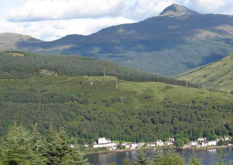
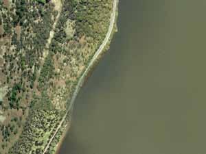
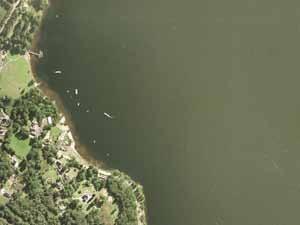
1 Settlement Review - Drymen and Balmaha 04 Drymen is a vibrant rural village with a strong and active community of all ages. The community take pride in the historic character of the village centre, with the square at its heart, and want this to be preserved and enhanced in the future. This is why there is a particular sensitivity about new development in the village. Drymen struggles with traffic during the summer months, as people flow through to get to Loch Lomond. Balmaha is a small settlement in a scenic location in an environmentally special setting on the eastern edge of Loch Lomond. During summer months, it can be extremely busy with daytrippers. The community at Balmaha are concerned about development of holiday accommodation and do not want to see an imbalance created between local inhabitants and transient visitors. There are strong and active tourism based businesses in Balmaha, and there is a feeling that there is potential to manage existing visitor numbers better whilst improving the visitor experience and generating more local income.

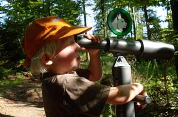
![[Drymen] Balancing demand for visitor accommodation with the concern that the local people feel about a potential dominance of visitor accommodation within a small existing community.](/docs-images/95/123049485/images/2-1.jpg "[Balmaha] Visitor orientation, particularly for long distance walkers and those arriving on public transport.")
2 What the community said Key Issues Balancing the need to have a sustainable, active community of all ages in the future, necessitating affordability and variety in local housing stock, with the desire to preserve the current feel and character of the village. [Drymen] Balancing demand for visitor accommodation with the concern that the local people feel about a potential dominance of visitor accommodation within a small existing community. [Balmaha] Visitor orientation, particularly for long distance walkers and those arriving on public transport. [Drymen] Access to the loch, both in getting to Balmaha, and then once in Balmaha enjoying the lochside, water based activities and transport links. Low cost business space for those who wish to set up local enterprise, supported by appropriate broadband access. Regarding facilities for families - the community would like to see better playgrounds and local childcare is needed. There is inadequate local provision for public transport. The need for improved means of getting around on foot and bicycle, within the village and between Drymen and Balmaha. Traffic through the village, particularly through the summer months. [Drymen] Parking; currently insufficient and causes issues where it is on street and blocks dual flow of traffic on the Main Street. {Drymen] The village square; finding a way forward with the scheme for improvement, promoting active and appropriate use of all buildings on it and helping to realise its full potential as the physical heart of the community. [Drymen] 48

3 Visitor Economy Headline Analysis Current Assets: Service Centre; Landscape Setting; Tourism Gateway; Rural Character Services Attractions Infrastructure Hotels Loch Lomond Millennium Forest Path Guest House and B&Bs Drymen - Village Green West Highland Way Self-Catering National Park Visitor Centre Rob Roy Way Bunkhouse Restaurants Waterbus Ferry to Inchcailloch Ferry to Luss Waterbus to Balloch in Jul/Aug Fishing Boat Hire Visitor Experience Enhancements: Eastern Gateway to Loch Lomond Drymen visitor market; Projected indicative day trip visitor travel zones Jura Consultants Cycling routes linking Drymen and Loch Lomond/Balmaha Campsites Walking routes linking Drymen and Loch Lomond/Balmaha Village square improvement (Drymen) Conservation area renewal (Drymen) Toilets Parking Better signage 49
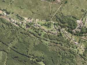
4 Drymen - Spatial Analysis Traffic pressure on Balmaha Road particularly during summer months as the means of accessing Loch Lomond from the east Green edge, defined by woodland Balmaha Road Primary school within large green site on north edge of village The northern part of the village is predominantly twentieth century housing developments of varying ages. There is a predominance of cul-de-sac type dead ends, which means that this part of the village isn t very permeable ie. Everyone relies on the main roads to get around even when on foot or bicycle Stirling Road to Stirling Eastern approach is dominated by post-war housing of varying quality Village centre around square and on Main Street A811 The A811 keeps through traffic away from Drymen. This also means that Drymen has to attract people as a destination in itself Viewpoint High point in village, this edge has high visibility and challenging topography Main Street Southern approach retains historic village character Village footprint 50 to Balloch and Glasgow Green space - park, woodland etc. Primary roads Shop and business frontages


5 Drymen - Character Rural character to eastern approach to village, punctuated by mature trees. Village edge to east is least defined, compared to other approaches and characterised by post war developments of varying quality. Main Street and south approach to village square, which has generally retained its historic rural character. The Salmon Leap gap site is shown to the right. The historic square is the physical and social heart of the village and is generally well maintained. There are opportunities to improve uses within buildings on the edges of the square to create more activity. East approach to village square with the village shop and the Drymen Inn providing much of the local activity and pedestrian footfall. The village square is the centre of the village, and reaching it lets you know that you have arrived in Dymen. The scale of the space and surrounding buildings means it is a pleasant place to be, although there is a dominance of tarmac in the foreground due to a sweep in the bend, meaning it is intimidating to cross on foot. Residential development to the north of the village, characterised by generous gardens with houses stepped back from a narrow street. This street is the only link to the village centre due to a predominance of cul-de-sac development. There are some issues here with families walking to the primary school alongside traffic. Images are captured from Google street view 2013 Google 51

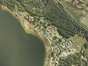
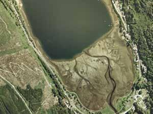
6 Balmaha - Spatial Analysis Wooded hillside, providing backdrop to the village main carpark and Balmaha Visitor centre This area is relatively underdeveloped and screened from the road Walkway along the loch to the north of the village Visitor attractor and primary service provider, Oak Tree Inn tree belt Balmaha s key asset: the loch Key arrival sequence includes open views of the loch B837 To Drymen no current access to walk along lochside south of the village Small scale housing clusters scattered along road Village footprint Green space - park, woodland etc. Primary roads Views to the water 52


7 Balmaha - Character Eastern approach to Balmaha has a special quality, with an avenue of mature trees and glimpses of Loch Lomond. The loch provides a stunning setting and view. However there are few places within Balmaha from which to sit and enjoy the view, or gain public access the water. The road through Balmaha is characterised by the loch on the left and the backdrop of the heavily wooded hillside of the Queen Elizabeth Forest Park. Balmaha contains a large carpark, which is a necessity for the visitor numbers during the summer months. Images are captured from Google street view 2013 Google 53


8 Drymen - Strategic Principles Maintain and enhance the character of Drymen as a rural village. Prioritise any new growth in a concentric way, so that the village continues to cluster around the heart of the village square. Strengthen the village centre by making use of gap sites for visitor and business activity in and around the square. Any future growth should incorporate interconnected pedestrian routes to the centre of the village to promote walking over car use. 54

9 Drymen - Strategic Principles outdoor activity hub for young people including tennis and football, sheltered by planting rob roy way NCN7 The currently designated Quarry Site to the south east of Drymen was not raised during the community engagement process but can still play an important role in developing a major leisure development in the Park. However, it is recognised that this would entail a significant level of investment which may not be immediately forthcoming so its continued allocation for should not be a barrier to smaller scale visitor accomodation in appropriate locations around the village. preserve natural edge 1 4* improve eastern edge of village 3 key initiative 1 Foxglove Cottages hotel and selfcatering holiday let - at appeal, Reporter minded to approve 2 key initiative opportunity - for discussion - make more use of showground parking area, to ease summer congestion and link to new/improved path network 2 prioritise gap site development within village Growth * consented schemes preferred next development - gap site mixed use response to demand - next most appropriate site site to be considered as next most appropriate, see below football pitch is key local amenity under ownership of the community, site is shown as next most appropriate for the village as a whole, but only if clear demand can be demonstrated and the community can benefit from relocated football pitch and improved facilities core paths west highland way NCN7 development - residential (dashed line consented, solid line potential future) Reproduced by permission of Ordnance Survey on behalf of HMSO. Crown copyright and database right All rights reserved. Ordnance Survey Licence number development - mixed (solid line potential future) development - visitor economy (attraction, food/drink, accommodation etc.) 55


10 Drymen - Strategic Principles The community of Drymen were clear on two of the things that they felt make it a great place. The first was the character of the village, its size and feel, mix of historic and new, all clustered around a village square. The second was the community itself; vibrant, engaged with a mix of all ages. This is supported by a good primary school, facilities at the village hall, hardworking local businesses and the energy of the community. The key question discussed during the Charrette was how to sustain this life and diversity in the community, whilst maintaining the existing character of the village. Should there be new housing, so as to maintain a mix of types and affordability? If so, how much and where? this number of new houses, if built out, could have an impact on the village and there s reluctance to support more in the immediate future. Small scale organic growth is favoured in the future. This has to be managed with future capacity and investment in local amenities, such as the primary school. Areas to the east of the village have been identified as possible areas for future growth, as they are considered to have the least impact on the village setting and will achieve the dual purpose of improving the east edge of the village. The Gartness Road proposal, which has been granted planning permission, includes 36 new homes in total, though this scheme has yet to be implemented. It was the view of the community that current east edge of village (Google streetview) new housing should be of appropriate form and scale for Drymen and make use of tree planting and varied building orientation to soften the boundary edge between houses and countryside 56
11 Drymen - Strategic Principles Existing village layout Four principal routes meet in the middle at the square. Cul-de-sac type dead ends in existing housing to the north, east and west mean that each residential street is a self contained branch off the main routes. This is not in keeping with current guidance on residential design, which promotes permeability and the ability to allow future growth to link into the existing network of routes. The southern approach to the village retains the historic rural character which should be maintained and enhanced. Potential growth The main opportunity for growth in terms of what is most appropriate for the landscape and spatial pattern of the village is to the east. This also presents an opportunity to repair this edge by improving the eastern approach to the village and create a joined up approach to future housing phases in the village. 57
12 Drymen - Housing Development Context A note on housing need in Drymen Facts and figures B Resident population: 681 Age structure: Under % 16 to pensionable age 53.9% Pensionable age and over 30.5% Average household size: 2.07 A Tenure: Owner occupied 74% Social rent 18% Private rent 8% Social housing Current total stock: 65 units Proposed as part of already granted schemes: Gartness Road: 10 Stirling Council have an existing waiting list of 20 applicants who identify Drymen as their preferred choice of allocation area. Half of these require a 1 bed home. Currently Consented Development Site A: 36 homes, 10 of these to be affordable social rent Site B: 3 homes Reproduced by permission of Ordnance Survey on behalf of HMSO. Crown copyright and database right All rights reserved. Ordnance Survey Licence number Rural Stirling Housing Association have an existing waiting list of 26 applicants with a local connection to Drymen. 16 of these require a 1 bed home. Private housing Average purchase price: 333,800 (Scottish average 154,810) Market Rent levels: (Scottish average 670) 58 Population and Households Census Social housing stock - Council and Registered Social Landlord records Analysis of Private Housing Market (CHMA Datapack 2012 & s1homes.com) Gathered for the purpose of this document by the Stirling Council with information from RSHA
13 Drymen - Housing Sites Options Review A Encourage development of consented proposals. Support a series of small scale infills which reinforce Village centre and maintain its historic character. B If a further allocation is required then Site B could be considered as it can repair an edge on an important approach. This would need sensitive landscape screening. C Some of the options discussed during the Charrette - Options A and B were deemed to be preferred with option C raising concern about relocating the community football pitch. Over the longer term Site C could be considered if justified by housing need. Maps on this page reproduced by permission of Ordnance Survey on behalf of HMSO. Crown copyright and database right All rights reserved. Ordnance Survey Licence number

14 Drymen - Key Initiatives The square is Drymen s heart, both for the community and for the many visitors who pass through. Lots of hard work has already been undertaken to seek to improve the public realm of the square for the future wellbeing of the village. This proposed initiative is about re-energising that process, and suggesting that there may be ways to achieve important goals with a more achievable budget. The key focus of any improvements should be on this being considered as a conservation project with a key aim of enhancing and maintaining the square s historic character and heritage. New consistent paving surface to integrate the Square and reduce the dominance of the road Encourage development of former garage building as a centre for start up for craft based businesses New surface acts as a differentiation between the existing road surface and reclaims the square as a pedestrian space with limited, managed, parking 60 Main road narrowed to slow vehicles, allow easier crossing and enhance the heart of the village New, clearer crossings highlighted through change of material and/or colour to make vehicles more aware of pedestrians


 to differentiate it from the road. Limited areas of stone paving around the green.")

15 Drymen - Key Initiatives Moving the Square public realm proposals forward Step 1 Evaluate the cost for the existing scheme - what costs a lot and where can savings be made? Step 2 Examine what it is that needs to be achieved and what the priorities are. Is it that the square should be safe and pedestrian friendly? Can elements of the scheme be progressed more quickly to achieve this immediate goal? Step 3 Look at how the square is used, particularly during the summer. Are there temporary low cost projects that can be initiated with the help of the businesses on the square to create an outdoor social space for the village, both for the community and visitors passing through? Option A - Lower specification / cost Ideas... New shared surface around square could be buff coloured resin surface or tarmac (as Callander Main Street) to differentiate it from the road. Limited areas of stone paving around the green. Option B - Higher specification / cost Ideas... All new stone surfaces within the Square, allowing differentiation in colour and texture to the main road. a place to get together as a community a place to sit and spend time a place to discover Reproduced by permission of Ordnance Survey on behalf of HMSO. Crown copyright and database right All rights reserved. Ordnance Survey Licence number Crown copyright and database right All rights reserved. Ordnance Survey Licence number Crown copyright and database right All rights reserved. Ordnance Survey Licence number village square 61


 and workshops below (responding to community need for affordable business space).")
16 Drymen - Key Initiatives Sensitive gap site development is seen as a positive thing by the community in Drymen. Development of the Salmon Leap site has been identified as part of the community s top ten priorities in the new Community Action Plan. The Site North of the Graveyard Lower level carparking for visitors to Drymen if possible, site levels pose a significant challenge. Residential development with a view to investigating suitable housing typologies to best respond to local need. The Salmon Leap Site Multi-level mixed use development creating frontage to the Main Street, with for example: one bed flats above (responding the greatest housing need) and workshops below (responding to community need for affordable business space). 62 Reproduced by permission of Ordnance Survey on behalf of HMSO. Crown copyright and database right All rights reserved. Ordnance Survey Licence number

17 Drymen - Key Initiatives: Salmon Leap Illustration Key aims of gap site development: 1. mixed use development that reinforces the centre of the village 2. creation of active frontage onto the Main Street 3. use of gap sites promotes concentric, organic and sustainable growth of the village mixed use with small business on ground floor and residential above space for on-street parking interpretation of vernacular form and scale gap site development 63


18 Balmaha - Key Initiatives Balmaha Drymen 64
19 Balmaha - Key Initiatives The means of getting to Balmaha needs to become an enjoyable and special experience in itself. A family day out can include leaving the car south of Drymen, cycling to Balmaha, lunch and activities in Balmaha, cycling back and evening food and drink at Drymen. Crown copyright and database right All rights reserved. Ordnance Survey Licence Number Aerial Photography (c)getmapping plc : Incorporate a means of experiencing the Endrick mouth National Nature Reserve The road to Balmaha - a 20-25min cycle or a 1 hour 20min walk 2: Carry out improvements to existing paths to allow biking for all abilities 1: Promote use of existing established path network The summer traffic congestion experienced by Drymen and Balmaha could alleviated, to a degree, by encouraging visitors to take different modes of getting to Balmaha and Loch Lomond. A new cycleway and footpath from Drymen and water based transport would enhance the experience for visitors. linking drymen & balmaha Crown copyright and database right All rights reserved. Ordnance Survey Licence no Aerial Photography Getmapping plc


20 Balmaha - Strategic Principles 66 Create a feeling of arrival in Balmaha, so that people are encouraged to get out of their cars and can explore. Make the most of views of the loch and access to the water. Promote visitor uses that make more of the potential to capture spend, while creating a unique visitor experience. Allow appropriate residential development to the north of the approach road, maintaining the strong treeline along the road edge, but keep the south clear of development to allow glimpses of the water on approach to Balmaha. Balmaha Bay New England seafood restaurant Boothbay, Maine Canoeing in Scotland

21 west highland way Balmaha - Strategic Principles west highland way key initiative room for expansion of carpark, but only as part of a wider management scheme with impact from extra vehicles assessed village can accommodate some residential development on north side of road, screened behind tree line shut road past junction with road north to Rowardennan to general traffic develop boat access so more trips can be made to and from Balmaha, from Balloch, Luss, and Rowardennan discourage development south of road where it blocks views of loch from approach pursue possibility for path link to endrick mouth national nature reserve and link back to drymen (see key initiative) key initiative (improved cycle access from Drymen, route tbc) Reproduced by permission of Ordnance Survey on behalf of HMSO. Crown copyright and database right All rights reserved. Ordnance Survey Licence number indicative NNR core paths development - residential development - visitor economy (attraction, food/drink, accommodation etc.) 67

22 Balmaha - Key Initiative Access to the west side of Loch Lomond, the generally quieter side of the loch, makes Balmaha an extremely special place in the National Park. It s challenge is in making the most of its appeal to visitors, whilst managing the impact of existing visitor volume. There is a clear opportunity, however, to enhance the experience of being in Balmaha. 68 Balmaha could be enhanced by a new pier or viewpoint in the bay looking out towards Inchcailloch


23 Balmaha - Key Initiative The experience of enjoying the water s edge is the primary reason why many people come to spend time in Balmaha. Balmaha already has a reputation as a great place to spend the day and get some nice food, and this reputation can be enhanced by future initiatives at the water s edge. The emphasis should not necessarily be about attracting more visitors, but on making the visitor experience higher quality so that it continues to be a special and memorable place in the future. This also means that the local community can benefit from more income without increasing levels of visitor footfall. The proposals shown opposite is an outline sketch of what might be, on Balmaha s waterfront, within the site outlined in purple on the Strategic Principles page. The key thinking behind the approach is that linear buildings oriented at right angles to the waterfront draws the view into the site and the spaces between the buildings, and gable ends provide opportunity for great indoor and outdoor terrace dining spaces. The road could have a shared surface to slow traffic and encourage pedestrian activity and a pier, albeit in this location not suitable for larger boats, would provide opportunity to walk out and fully enjoy the experience of being in Balmaha. Improved frontage onto the loch Some ideas mentioned by the community include a smokehouse, restaurant/cafe and micro-brewery. These would be ideal uses for this site. water s edge 69
24 70

25 Settlement Review - Tyndrum 05 Tyndrum is a small village that has evolved as a staging post on a confluence of routes that connect central Scotland to the north west coast. Local businesses have capitalised on the large numbers of travellers passing through and it is a recognised place to stop on this key route. It also benefits from a steady flow on long distance walkers on the West Highland Way. Tyndrum s setting is much wilder and more rugged than the rest of the Park. It is distinctly Highland in character, surrounded by munroes, and receives more extreme weather. The community in the village feel very connected to Crianlarich as one Strathfillan community. However the community does feel remote from other communities in the Park. Access to facilities such as a leisure centre or the High School mean a 50 minute drive to Callander and shopping may mean a 50 minute drive to Oban. This does mean that there is a feel of self-reliance and resilience which is a positive thing for the future of the village. The proposed Cononish Gold Mine means change for Tyndrum in the future and the community are keen to make the most of this opportunity to stimulate the local economy.. 71


26 What the community said Key Issues The principal concern was how to make more visitors stop and spend more time and money in the village rather than just passing by on their way to somewhere else. The Green Welly Stop captures a significant number of passers by but there is little else for them to do in the village when they stop. The environment surrounding the trunk road is inhospitable to pedestrians which discourages people from exploring the village. Traffic speeds are too high and crossing the trunk road feels dangerous. There is seen to be an urgent need for a new cycle path to Crianlarich for school children and visitors. Public transport, principally buses, is considered to be inadequate. The trains are underutilised by visitors and the stations feel remote from the village. High energy costs are an additional challenge for those living on low incomes in a remote rural location with harsh winters. There are few facilities for families and children. The activities in the area are seen to be underutilised and under appreciated by visitors. There is a desire to make Tyndrum more of a destination. The Gold Mine is expected to bring jobs and visitors and create a demand for new homes. Visitor accommodation is largely focussed on coach tours and single overnight stays from the West Highland Way. 72


27 Visitor Economy Headline Analysis Current Situation Synonymous with the Green Welly Stop Services Attractions Infrastructure Hotels The Green Welly Stop West Highland Way Guest House and B&Bs Real Food Cafe Upper Tyndrum Station Self-Catering Tourist Information (seasonal) Tyndrum Lower Station Camping and caravanning Visitor Experience Enhancements Worth breaking your journey for Day trip destination Gold Mine Visitor Centre Village amenity Enhanced Tourist Information Centre Toilets Play Park Landmark sculpture 73

28 Tyndrum Spatial Analysis The A85 road to Lochawe and the West coast A85 A82 The A82 is a trunk road going directly through Tyndrum. This brings people into the town but brings its own problems related to through traffic west highland way A82 The Green Welly Stop river Fillan Real Food Cafe Village footprint Tyndrum Lower Railway Station west highland way A82 Upper Tyndrum Railway Station Green space - park, woodland etc. Primary roads Caravan park Railway line 74


29 Tyndrum Character Southern approach to Tyndrum along the A82 road from Crianlarich. Real Food Cafe along the A82 trunk road with carparking and seating outside. Caravan park entrance with Brodies mini-market with the beautiful backdrop of wooded hills. Driving through Tyndrum with The Green Welly Stop ahead. The town is very small with low density. Buildings are scattered along the A82 road, usually set back from it. The Green Welly Stop, a very important services and amenity point on the way up to north and west Scotland or down to the central belt of Scotland. Approaching Tyndrum from the north along the A82 road opens scenic lush green views toward the Loch Lomond and Trossachs National Park. Images are captured from Google street view 2013 Google 75


30 Strategic Principles The key challenge in Tyndrum is how to make it a place that encourages people to stop and dwell rather than simply pass through or just quickly refuel at the famous Green Welly Stop. How to make it less like this.... How to make it the natural centre and orientation point for the wide range of activities in the area. A local hub for the community and visitors that is well connected to an integrated network of roads, railways, cycle paths and footpaths.... and more like this. Create focus at the centre, where all routes converge, and main visitor uses are. Encourage depositing of car and movement through the village on foot. Create more direct connections between the train stations, and the centre of the village. Allow pockets of housing around the central village space, and avoid linear ribbon development along the trunk road. 76

31 Strategic Principles the view from the train station on this side is a key strength for Tyndrum, of the town and the mountains opposite and development on this side of the watercourse should be discouraged this is a key site in the village and offers huge potential to become the centre with a combination of visitor amenity and quality external space key initiative west highland way key initiative if residential development is required to respond to an identified need, it is suggested that the area to the east of the village should be a priority for phased development to reinforce the existing homes and in terms of landscape impact, this area is sheltered by the community woodland tree structure planting key initiative improved access from the train station with a path that weaves through the community woodland a new approach from the train station would enhance the arrival sequence into the village, and possibly tie in with managed access to the gold mine, with a safe railway crossing west highland way new cycleway to Crianlarich (initiative already in progress) core paths development - residential Reproduced by permission of Ordnance Survey on behalf of HMSO. Crown copyright and database right All rights reserved. Ordnance Survey Licence number development - visitor economy (attraction, food/drink, accommodation etc.) 77
32 Tyndrum - Development Strategy Options During the Charrette process, three options for the centre of the village were discussed. These options all centred around common themes: Creating a sense of a village and a place, rather than a collection of buildings dotted on either side of a trunk road. Identifying key sites within the village, that are critical to this feeling of place. Looking at arrival sequences, by train and by road. Using means to slow traffic that is in keeping with current thinking, a speed limit sign alone is difficult to enforce, but the feeling that you are passing through a place encourages caution and a natural reaction to slow a little. Tyndrum - Option A continue strategy of defined parking areas that are visible to people passing through, soften with landscape treatment retail/visitor use with active frontage reinforcing the definition of the village centre by clustering new development West Highland Way encouraging more people to dwell and spend time in Tyndrum threshold spaces - change in character so drivers know they are in a village improved frontage with walkway and planting housing around central landscape area defined pedestrian crossings at strategic points improved and more direct links to the train stations threshold spaces - change in character so drivers know they are in a village new cycle/pedestrian pathway linking Tyndrum with Crianlarich Crown copyright and database right All rights reserved. Ordnance Survey Licence no Aerial Photography Getmapping plc 2010 measures to encourage A82 traffic to slow down Encourage walking within the village, rather than reliance on the car for trips between buildings. attractive public realm to south side of road to encourage pedestrians to explore the village new retail/leisure frontage to south side of the A82 starting with a review of how the Tourist Information Centre can be enhanced new housing site around a village green to south of road new, direct, pathways between the railway stations and the village centre 78 new cycle path connection with to Crianlarich
33 Tyndrum - Development Strategy Options Tyndrum - Option B Tyndrum - Option B possible residential development options continue strategy of defined parking areas that are visible to people passing through, soften with landscape treatment improved and more direct links to the train stations Crown copyright and database right All rights reserved. Ordnance Survey Licence Number Aerial Photography (c)getmapping plc 2010 West Highland Way threshold spaces - change in character so drivers know they are in a village improved frontage with walkway and planting bunkhouse accommodation with active ground floor retail/visitor use with active frontage defined pedestrian crossings at strategic points threshold spaces - change in character so drivers know they are in a village new cycle/pedestrian pathway linking Tyndrum with Crianlarich Crown copyright and database right All rights reserved. Ordnance Survey Licence no Aerial Photography Getmapping plc 2010 Tyndrum - Option C Tyndrum - Option C possible residential development options continue strategy of defined parking areas that are visible to people passing through, soften with landscape treatment improved and more direct links to the train stations Crown copyright and database right All rights reserved. Ordnance Survey Licence Number Aerial Photography (c)getmapping plc 2010 West Highland Way threshold spaces - change in character so drivers know they are in a village improved frontage with walkway and planting goldmine interpretive visitor facility retail/visitor use with active frontage defined pedestrian crossings at strategic points threshold spaces - change in character so drivers know new cycle/pedestrian pathway linking Tyndrum with Crianlarich Crown copyright and database right All rights reserved. Ordnance Survey Licence no Aerial Photography Getmapping plc 2010 As Option A but: As Option A but: bunkhouse accommodation in village centre to encourage more overnight stays village centre focused on Gold Mine related visitor facility new housing land provision to north of village centre to take advantage of elevated, south facing, views and to south west new green space linking visitor facility to surrounding landscape and forming an arrival space from the new pathway from the south railway station new housing land provision only to north of village centre to take advantage of elevated, south facing, views and to keep the important arrival vista clear from the south station 79


34 Key Initiatives These proposals illustrates how Tyndrum can be enhanced by creating a new heart for the village which will give it a stronger identity and a clearly defined centre of gravity to encourage visitors to stop and spend more time there. A key principle is making the environment around the trunk road more welcoming to encourage pedestrians to get out of their cars and explore the village. The new centre is linked to new, more direct, pedestrian and cycle connections from the two stations that engage visitors in the Highland landscape to heighten the experience of arrival in a special place. Approach from the south station The southern approach opens up a magnificent view of Tyndrum in it s mountain terrain setting whilst the northern approach presents the opportunity of a path through the community woodland. Both routes will bring the visitors right into the heart of the village. 80 Approach from the north station

35 Key Initiatives Tourist Information Centre optimised with craft retail New, direct, pathway to railway station linked with cycleway to Crainlarich and West Highland Way Potential Gold Mine Visitor Facility. Orientation point for visitors and departure point for trips to mine West Highland Way Village arrival gateway with traffic calming Village centre enhanced to encourage passing visitors to stop and spend time in Tyndrum Sheltered boardwalk frontage to retail and leisure facilities New pathway to railway station Housing expansion to north Real Food Cafe Crossing point Crossing point The Green Welly Village arrival gateway with traffic calming West Highland Way village centre If needed, housing expansion to north, structured so it can evolve into an integrated network of connected streets rather than cul-desacs 81


36 Key Initiatives A short to medium term goal for the village should be improve the environment for pedestrians. This could be achieved by constructing a covered walkway along the west side of the trunk road which would respond to a number of Tyndrum s aspirations for the future: It would create a continuous frontage onto the road, in advance of development of the site. It would create a sense of arrival into the centre of a village, with the psychological effect of making traffic more aware of people. It would encourage pedestrian movement between the businesses in the village. With the appropriate design it could be a significant landmark on the West Highland Way and be utilised for outdoor heritage display and visitor orientation. 82

37 Key Initiatives The walkway should be set back from the road, with a green buffer between pedestrians and traffic. Crossings should be located where people naturally want to cross the road. Although this is a trunk road, there are measures that can make the environment more people friendly, in line with the Scottish Government s Designing Streets guidance, acknowledging that Tyndrum needs to feel more like a village and less like a road with a collection of buildings on each side. village centre 83


38 Key Initiatives Although the Gold Mine is not critical to the future of Tyndrum it presents a significant opportunity for the village to become a unique visitor destination and the gateway to the Gold Mine. The Cononish mine is located near the village, and Tyndrum would be the natural base point from which to explore the story of mining in the area. This could include heritage and information, family based activities and a managed means of walking or getting transport to the mine itself if the opportunity to have on-site visitor interpretation is also realised. Cononish mine Tyndrum The area already has mining heritage, with a former local lead mine, and there is a wider story to be woven in, with local walking routes in the local landscape. 84


39 Key Initiatives A key priority will be to test the feasibility and potential for a mining heritage centre in the village. The location of a mining heritage centre in the centre of the village can be a key catalyst for moving Tyndrum forward from principally being perceived as a staging post to a visitor destination in its own right and will provide the key connection to the Cononish Goldmine. There are a number of strong precedents around the world for successful visitor facilities associated with mining which are illustrated below. Gold Ecological Park Taipei Gold Museum Taipei Nickel Museum Ontario Big Nickel Ontario gold and mining 85
40 86

41 Settlement Review - Arrochar & Tarbet 06 Tarbet and Arrochar/Succoth share one vibrant and active community. They are set within the dramatic landscape of west Loch Lomond at the northern tip of Loch Long with dramatic views to the Arrochar Alps to the west. Both principal villages suffer from the fact that they have become passing through places rather than destinations. Their configuration around trunk roads, the quality of the public realm and the local retail and leisure offer does not encourage visitors to stop. They are still beautiful places and there is significant potential to be harnessed. This potential is already demonstrated by the recent planning consent for the Ben Arthur resort across the loch. It is critical that the villages, and in particular Arrochar, plays to its inherent strengths and harnesses these qualities for the benefit of the community and the long term wellbeing of the villages. 87


42 What the community said Key Issues The three villages benefit from a stunning setting, with the Arrochar Alps, Loch Lomond and Loch Long. Arrochar is currently seen as a passing through place, it is difficult to stop and spend time. Tarbet has a similar problem, though it does have more opportunity to stop and view the loch. Arrochar is missing a centre, which is the focus of community and visitor activity and gives the feeling of arrival into the village. The three villages are one community and links that strengthen this relationship are welcome. There is particular desire from families in Arrochar to have a safe route to walk or cycle to school in Tarbet, the road is too dangerous and pavement too narrow. People are keen to see more jobs created in the area with living wages to give young people opportunity to stay in the area. Arrochar and Tarbet have a rich, interesting, heritage that should live on in learning and education and can be a key part of creating an identity for the area that attracts the interest of visitors. There will need to be a continuing availability of homes for young families and first time buyers, and for elderly people who need care and accessibility. The proposed development at Ben Arthur will bring significant change to the area, and there is a desire to make sure that Arrochar sees some benefit from its proximity to such a large visitor destination. There is a feeling that enough isn t made of outdoor activity in the area, and the visitors who come to walk, hike, cycle and dive. It was felt that orientation, better facilities and a variety of budget accommodation would mean more people see Arrochar as a destination. 88

43 Visitor Economy Headline Analysis Current Assets: One Community; Three Villages Services Attractions Infrastructure Hotels Arrochar Alps Arrochar and Tarbet railway station Guest House and B&Bs Loch Lomond Argyll Forest Park / Ardgartan Self-Catering Loch Long Glen Lion Footpath Camping and caravanning Mansefield Studios Tarbet loop Cruise Loch Lomond Local Archaeology Arrochar walk Loch Lomond Seaplane Fishing Succoth burn Stronafyne Loop The Cobbler Cat Craig cycle loop Ardgartan Peninsula Circuit Three Lochs Way Visitor Experience Enhancements: A day visitor destination for adventure seekers; Arrochar Alps, Loch Lomond and Loch Long Increase visual impact of arrival to Tarbet and Arrochar Village square Parking Visitor attractions Arrochar pontoons Conservation area renewal Public realm improvements - Arrochar Pier Toilets, showers Cultural heritage Visitor orientation Paths - Arrochar to Ben Arthur Resort; Succoth/Arrochar/Tarbet/railway station 89

44 Tarbet - Spatial Analysis Argyll Forest Park current development is predominantly north of the A83/ A82 - this is all residential railway Tarbet Visitor Information Centre Arrochar and Tarbet Railway Station A82 Arrochar Primary School Beautiful views to the loch along the A82 Loch Lomond Carpark Village footprint Green space - park, woodland etc. A83 trunk roads diverge at Tarbet, creating the impression of a junction rather than a village Tarbet Hotel Carpark A82 Tarbet pier Tarbet pier is the village s key asset and there is generous green amenity space from which to enjoy the lochside setting Primary roads Railway line 90 Views to the water


45 Tarbet - Character A historic view of Tarbet pier. The prominent Tarbet Hotel on Old Military Road, this is the landmark that signals arrival in Tarbet. A view along the A82 road north direction Succoth showing the narrow road with green threshold planting to the right and view towards the Loch Long and the hills beyond to the left. The pleasant view to Loch Lomond and Tarbet pier from a visitor carpark. A typical residential street parallel to Old Military Road with the wooded backdrop of Argyll Forest Park. Tarbet Visitor Information Centre. Images are captured from Google street view 2013 Google 91

46 Arrochar - Spatial Analysis to Succoth Services and amenities to lochside. The road is very narrow and not offering adequate opportunities for stopping to Succoth slope Argyll Forest Park A wooded hillside provides a backdrop to Arrochar A83 A83 Green edge, defined by woodland. Arrochar Coach Hotel. The approach is very narrow with no place to stop. Its single frontage on one side blocks the loch view A83 to Tarbet to Ardgartan Loch Long threshold planting Beautiful views to Loch Long all along the A814 and the A83 as it follows the shape of the loch through Succoth Church railway Village footprint Green space - park, woodland etc. A814 Primary roads 92 housing developments to the south of Arrochar of varying quality Railway line Shop and business frontages Views to the water


47 Arrochar - Character A historic image of the Arrochar Pier with The Cobbler and paddle steamers. Beautiful views to Loch Long and the Cobbler. This view looks across the top of the site behind the Three Villages Hall, later identified as a key initiative site. Beautiful views to Loch Long and its opposite shore along the A841 road through Arrochar. View looking south along the A814 road to a residential development with the backdrop of Argyll Forest Park. View north along the A83 road showing Arrochar Coach Hotel on the right and businesses right against the narrow road and pavement on the lochside. At the church, there is a change in character as buildings are more set back from the road travelling south. Images are captured from Google street view 2013 Google 93

48 Succoth - Spatial Analysis Loin Water Succoth residential areas Wooded hillside A83 Petrol Station views to Loch Long all along the A83 Carpark Holiday homes park Green edge, defined by woodland 94 Village footprint Green space - park, woodland etc. Primary roads Railway line Shop and business frontages to Ardgartan Loch Long to Arrochar Services and amenities to lochside. The road is very narrow without adequate opportunities for stopping


49 Succoth - Character Succoth petrol station and the entrance to a holiday homes park. A residential street in north Succoth. Beautiful views from a road bridge over Loin Water on Old Military Road looking towards Loch Long. View of a landscaped visitor carpark at the entrance to Succoth from Arrochar with the backdrop of Argyll Forest Park. A view north along the A83 with Loch Long on the left and Succoth ahead. A view south along the A83 back to Arrochar with visitor carpark on the right. Images are captured from Google street view 2013 Google 95

50 Strategic Principles - Three Villages The Three Villages can be viewed spatially as a cluster of settlements that needs a clear strategy for how they can support each other and be better connected. Arrochar and Tarbet both seem to lack recognisable village centres without a clear feeling of arrival or a sense of place for both their local communities and passing visitors. Succoth provides a complementary role for housing that can be enhanced by establishing it as village with it s own centre. All Three Villages are uniquely positioned, in extraordinary landscape settings, to capture much more from passing visitors to ensure their long term sustainability as rural communities. Tarbet and Arrochar can work as a pair of interrelated gateways that can support and enhance each other. The isthmus that connects them is the transition point between the expanse of the inland waterway of Loch Lomond and the sea lochs and alpine mountain landscape to the west. 96

51 All Three Villages need to discover a physical heart that will become the social heart of their communities, and a draw for visitors, and become more connected. Crown copyright and database right All rights reserved. Ordnance Survey Licence no Aerial Photography Getmapping plc

52 Key Initiative - Path Connections Existing options Crown copyright and database right All rights reserved. Ordnance Survey Licence no Aerial Photography Getmapping plc 2006


53 Key Initiative Option 1: Steep climbs and slippy in wet weather, so not suitable for elderly and young children due to gradients. Option 2: Pavement along the A83 trunk road with a pinch point under the railway bridge, not deemed safe for children, would require improvement and pavement widening, but this is restricted by the width of the railway bridge. Option 3: Away from the road and with reasonable gradients, requires significant upgrade to the surface, it is a longer route which is discouraging for those wishing to get to school. Option for discussion: Improve/widen path along road side option 2 so that it can take cyclists; on the Arrochar side of the railway bridge, create a link from this to path 1 as it passes behind the railway station, using a gradual slope and maintaining appropriate width for pedestrians and cyclists. Allow safe crossing of the railway at the station. The aim of this is to improve the pedestrian and cycle link between the two villages, and also between the station and Arrochar, by avoiding the pinch point of the railway bridge. Recommendation: Test the feasibility of each of these options and prioritise it as a means of ensuring that the community and visitors can travel safely between Succoth, Arrochar and Tarbet. West Loch Lomond cycleway link cycle path 99


54 Arrochar and Succoth - Strategic Principles The fact-finding workshop established that Arrochar needs to be more of a stopping place than a passing through place. It needs a centre, a focus and a heart. A place where the community gather, spend time and show off the best of what their village can offer. This is where visitors know that they have arrived in Arrochar, a small, active village in a stunning setting, which is the gateway to the Arrochar Alps. This place should make the most of what is great and distinctive about the village; its setting, with the view of the loch and of the Cobbler. It should also acknowledge the real centre of gravity of the village, which is at the old pier and the Three Villages Hall. Succoth 2 residential development of appropriate mix and scale, with an emphasis on a choice of unit types and sizes for local families, first time buyers and the senior citizens 1 Succoth 1 3 village green with full size football pitch Ben Arthur alternate option for improved access to housing flood park and nature reserve improved additional access route will be required at some point, to be determined To Tarbet potential visitor accommodation development - residential Arrochar development - visitor economy development 100 Reproduced by permission of Ordnance Survey on behalf of HMSO. Crown copyright and database right All rights reserved. Ordnance Survey Licence number

55 Strategic Principles Arrochar walkway between Ben Arthur resort and arrochar village centre Key initiative key centre of village site Key initiative walking and cycling to Tarbet proposed Ben Arthur resort core paths development - residential Reproduced by permission of Ordnance Survey on behalf of HMSO. Crown copyright and database right All rights reserved. Ordnance Survey Licence number development - visitor economy development (dashed line approved, solid line potential future 101


56 Key Initiatives new civic space with community and visitor facilities new housing A83 Approach to Arrochar view to Cobbler through civic space Three Villages Hall green amenity space Arrochar Hotel heritage centre Arrochar needs a village centre Arrochar is a village in a unique setting. Ben Arthur, (popularly known as The Cobbler), and the old pier are memorable parts of what makes Arrochar special, both for people who visit and people who live here. The village at the moment feels like it is in two halves. The northern half is linear, built along the road, and largely comprised of local businesses. The southern half begins with the Three Villages Hall and is made up of most of the homes in the village. There is a key place where all of these meet; the two halves of the village, the pier and the some of the best views of The Cobbler and the hills opposite. This site has been identified as part of the Charrette, and early sketches and ideas illustrate the potential for what the centre of the village might become in the future. pedestrian priority public realm restored pier 102


 village centre Viking long boat house")
57 Key Initiatives Early sketches The restored Old Pier Improved loch frontage and public realm The Three Villages Hall Arrochar Hotel Mixed-use accommodation including potentially: heritage and interpretive use, food / retail and visitor accommodation Heritage/ interpretation space and/or public performance space Access from A83 into the village directly to central space (subject to dialogue with Transport Scotland) village centre Viking long boat house Trollstigen Norway Reykjavik 103

58 Strategic Principles - Arrochar and Succoth The site behind the Three Villages Hall was identified during the Charrette process as a critical site for the village. Conversations exploring how site might best serve the village have taken place as part of the Charrette process whilst acknowledging that there are emerging proposals from the landowner which have been the subject of pre-application discussions with the LLTNPA and community representatives. key view from village centre space, with the old pier in the centre and The Cobbler in the background The site presents a significant opportunity to create a key sense of arrival and a social heart for Arrochar, to encourage people to dwell, and spend more time and money in the village, rather than just pass through. This has a primary aim of enhancing the future economic wellbeing of the village but also has the wider benefit for the community of a high quality civic space that will reinforce the Three Villages Hall as social hub of the village. The diagram opposite outlines strategic guidance for the site, illustrating some of the key strengths that should be optimised, and achieving balance between uses. This includes: The view of the loch, the old pier and The Cobbler is uniquely special to Arrochar and represents its most attractive feature to visitors. This should be the civic and social heart of the village for visitors and the community. A public space framing the view with buildings from deep within the site. It will be this view of the space from the trunk road, with The Cobbler in the background, that gives a special sense of arrival in Arrochar encouraging people to stop in the village. buildings onto the village centre space should support the local economy, particularly the visitor economy, with small business space such as retail/outdoor equipment hire/leisure and budget accommodation. frontage onto the loch community green space building with active frontage onto the village centre village centre building with active frontage onto the village centre residential development of appropriate density carparking at back of the site key view of space and setting from the road Buildings adjacent to the public space should have ground level uses that activate the space and support the local visitor economy as well as the local community, such as heritage and interpretation, outdoor equipment retail/repair/ hire, cafe/restaurants and craft shops, with potential budget accommodation on upper floors. Site strategic guidelines Reproduced by permission of Ordnance Survey on behalf of HMSO. Crown copyright and database right All rights reserved. Ordnance Survey Licence number Any residential development should be of appropriate scale and density with higher elements pushed back toward the slope at the back of the site.
 for the community and visitors - summer event space for the three villages use of viking heritage to create identity and emphasise")
59 space for local business enterprise and visitor accommodation postcard view the pier and The Cobbler re-built pier with mooring space for a variety of boats What the space might feel like civic space to sit, wander and enjoy the view and the sun (when it shines) for the community and visitors - summer event space for the three villages use of viking heritage to create identity and emphasise location and setting village centre 105


60 Strategic Principles - Tarbet Tarbet suffers from a combination of factors which have inhibited its development and the quality of its environment for a number of years, principally: It is a busy roadside location between two trunk roads with little public space and few possibilities for visitors to stop. There is no discernable village centre for the community or visitors. The railway station is remote. There has been asymmetrical development to the west, along the road to Arrochar, due to limited land supply. The proposals on the following pages present strategic responses to these issues which should inform, and be used to co-ordinate, emerging masterplan proposals for the village. Tarbet needs a central, pedestrian friendly space, to avoid feeling like a junction of two roads, with small local businesses such as cafes and shops. Crown copyright and database right All rights reserved. Ordnance Survey Licence number Potential Option A for the future of Tarbet Create mixed use residential and small business spaces in the village, to achieve the following: enclosure on both sides of the road, to create an environment that is more village in character slow through traffic create a central village space that is linked to the lochside park sensitively design small scale low density housing into the hillside toward the south Re-aligning the road west would create a better pedestrian space alongside the Tarbet Hotel and a safer crossing to the lochside park. Sensitively designed residential development on the south side of the A83 can balance historic growth on the north. This should form a street frontage to the road edge with lower density within woodland to the south. More can be made of the lochside park with potential for improving access to the loch. Potential Option B for the future of Tarbet Follow the same principles as outlined above, and also re-align the road to create a more generous centre of the village space, more pedestrian space around the Tarbet Hotel and a safer means of crossing the trunk road junction at Tarbet. The key next step for Tarbet is for local landowners and stakeholders to create a shared and co-ordinated masterplan approach to secure the best future for the place and the community. 106 Crown copyright and database right All rights reserved. Ordnance Survey Licence number

61 Strategic Principles - Tarbet train station defined street frontage to road to strengthen village character create a new village centre to the west of the Tarbet Hotel by forming a civic space for the community and visitors that is linked to the lochside park create definition north and south of the lochside park enhance lochside park and access to the water improve connections to station encourage development to the southside of the A83 to redress the asymmetrical growth of the village due to land availability - grow this out from the village centre with a defined street frontage to the A83 with lower density visitor accommodation to the south, with appropriate access off the trunk road developed in discussion with Transport Scotland Reproduced by permission of Ordnance Survey on behalf of HMSO. Crown copyright and database right All rights reserved. Ordnance Survey Licence number


62 108
Schedule of Planning Applications Committee Date: 23 May Reference: 06/18/0064/F Great Yarmouth Officer: Mr J Beck Expiry Date:
 Schedule of Planning Applications Committee Date: 23 May 2018 Reference: 06/18/0064/F Great Yarmouth Officer: Mr J Beck Expiry Date: 24-04-2018 Applicant: Proposal: Site: Mr Mavroudis Clear weather hoardings
places Mooloolaba s heart five
 five places the mooloolaba heart 1 Flexible community event use of school oval 2 Enhanced streetscape District cycle route Future cross-block pedestrian link 5 Existing school buildings New signalised
Creating a High Quality Business District
 Date Month Date Month Friday 7 November 2014 Nine Elms on the South Bank A Bilfinger Real Estate company Creating a High Quality Business District New London Architecture Introduction Nine Elms Vauxhall
Llandudno Junction. Regeneration Proposals for the Future. December 2009
 Llandudno Junction Regeneration Proposals for the Future December 2009 Llandudno Junction - Vision Statement 1 Purpose 1.1 The purpose of this document is to describe key priorities to support the regeneration
The Sunshine Coast is part of the global community and generates wealth through export, high-value industries and new investment.
 3.2 Strategic intent 3.2.1 Shaping growth an overview In 2031, the Sunshine Coast is renowned for its vibrant economy, ecological values, unique character and strong sense of community. It is Australia
Councillor Briefing on Elvetham Chase
 Councillor Briefing on Elvetham Chase In partnership with the Calthorpe Estate, Wates Developments vision for Elvetham Chase is to provide an outstanding new community for Hart District that will become
Public Realm & Landscape
 Town Centre Context Public Realm & Landscape 1. Public realm in the Town Centre varies significantly in quality. Areas of particularly good quality public realm are located around the Minster and outside
Tourism Development Plan for Scotland Questionnaire
 Draft National Tourism Development Plan Public Consultation 2013 Tourism Development Plan for Scotland Questionnaire We would like your views on this Plan and, in particular, your comments on opportunities
URBAN DESIGN REPORT. Proposed Residential Development, Old Church Road, Caledon East
 Proposed Residential Development, Old Church Road, Caledon East TABLE CONTENTS: 1.0 DEVELOPMENT 1.1 Introduction-Analysis of Guiding Principles and Documents 1.2 Community Design and Architectural Design
Tourism Development Framework for Scotland. Executive Summary- Development Framework to 2020 for the Visitor Economy (Refresh 2016)
") Tourism Development Framework for Scotland Executive Summary- Development Framework to 2020 for the Visitor Economy (Refresh 2016) Introduction The Tourism Development Framework for Scotland refresh 2016:
Tourism Development Framework for Scotland Executive Summary- Development Framework to 2020 for the Visitor Economy (Refresh 2016) Introduction The Tourism Development Framework for Scotland refresh 2016:
Millport Charrette. Moving forward What do you think? Where are the opportunities? What are the priorities?
 Millport Charrette North Ayrshire Council invite you to share your views on marine tourism opportunities at Millport. North Ayrshire Council s Economy and Communities Team is keen to further develop Millport
JOINT CORE STRATEGY FOR BROADLAND, NORWICH AND SOUTH NORFOLK EXAMINATION MATTER 3C EASTON/COSTESSEY
 Matter 3C Easton/Costessey Representor No. 8826 JOINT CORE STRATEGY FOR BROADLAND, NORWICH AND SOUTH NORFOLK EXAMINATION MATTER 3C EASTON/COSTESSEY SUBMISSION ON BEHALF OF TAYLOR WIMPEY DEVELOPMENTS AND
Glen Innes Strategic Plan
 Glen Innes Strategic Plan 2018-2023 Photo credit: DKO Architecture Vision Statement Competitive Advantage Located at the heart of the greatest urban transformation project in New Zealand, the Glen Innes
Strategy - The Big Picture
 Appendix 1 Strategy - The Big Picture Cameron House Balloch Castle Maid of the Loch and Watersports Hub Loch Lomond Shores Walled Garden Development Site East Riverside Path West riverside Walk Moss O
Date: 11 th January, From: Plaistow & Ifold Parish Neighbourhood Plan - Steering Group. Plaistow & Ifold Parish Council
 Date: 11 th January, 2017 From: Plaistow & Ifold Parish Neighbourhood Plan - Steering Group To: Plaistow & Ifold Parish Council Re: Neighbourhood Plan Report to Parish Council Meeting 17 Jan 2017 The Steering
Camping Development Strategy
 Camping Development Strategy Approved 24 October 2016 Contents 1. Our vision for camping... 3 1.1 Our strategic vision... 3 1.2 The current experience of camping in the National Park... 4 1.3 Our approach
HARBOUR EDGE STITCH. Uniting the Waterfront with the City Centre
 78 AC_BEU_CCMP_2_TM1_4 _FD.indd 78 20/07/12 12:04 PM 01 HARBOUR EDGE STITCH Uniting the Waterfront with the City Centre 01 VISION OUR 2032 VISION IS: Quay Street as a high-quality Harbour Edge space that
Report to: Greater Cambridge Partnership Joint Assembly 18 January A10 Foxton level crossing bypass and travel hub
 Report to: Greater Cambridge Partnership Joint Assembly 18 January 2018 Lead officer: Chris Tunstall GCP Director of Transport A10 Foxton level crossing bypass and travel hub 1. Purpose 1.1 The list of
CRAIGBANK GUEST HOUSE, MAIN STREET, CRIANLARICH, FK20 8QS. A S GCommercial. Offers Around 420,000 (Freehold)
") CRAIGBANK GUEST HOUSE, MAIN STREET, CRIANLARICH, FK20 8QS A S GCommercial Offers Around 420,000 (Freehold) Substantial and attractive property providing an easy to operate home and income lifestyle opportunity
CRAIGBANK GUEST HOUSE, MAIN STREET, CRIANLARICH, FK20 8QS A S GCommercial Offers Around 420,000 (Freehold) Substantial and attractive property providing an easy to operate home and income lifestyle opportunity
COMMUNITY ACTION PLAN. Strathfillan GARTMORE 1
 COMMUNITY ACTION PLAN 2 0 1 4-2 0 1 9 Strathfillan GARTMORE 1 Strathfillan Community Action Plan 2014-2019 With support from the Loch Lomond and Trossachs Community Partnership we have now produced our
Perth and Kinross Council Development Management Committee 20 February 2013 Report of Handling by Development Quality Manager
 Perth and Kinross Council Development Management Committee 20 February 2013 Report of Handling by Development Quality Manager 4(4)(ii) 13/80 Replacement and re-positioning of street furniture, The Birks,
National Park Authority Board Meeting
 Paper for decision 1. Introduction 1.1 Preparations for the introduction of four Camping Management Zones (covering less than 4% of the National Park) have progressed significantly since Scottish Ministers
Destination Orkney. The Orkney Tourism Strategy Summary
 Destination Orkney The Orkney Tourism Strategy Summary Introduction Adopted by Destination Orkney (formerly Orkney s Area Tourism Partnership), the strategy rocket is a one-page summary of the strategy
West of England. Priority Places Requiring Public Investment
 West of England Priority Places Requiring Public Investment Development Urban Regeneration & Suburban Intensification Bristol Central Area Bristol Central Area; Stokes Croft, Temple Meads & St Philips
Business needs consumers! Get people back in to Port by attracting them!
 18 March 2013 Port Adelaide Precinct Plan Theme based analysis community feedback from Open Day Business District There were a range of suggestions for revitalising and boosting the Business District s
TOWN PLANNING SUBMISSION TO THE GREATER SYDNEY COMMISSION LANDS AT ARTARMON
 TOWN PLANNING SUBMISSION TO THE GREATER SYDNEY COMMISSION LANDS AT ARTARMON March 2017 TABLE OF CONTENTS 1.0 INTRODUCTION 3 2.0 THE SUBJECT SITE 4 3.0 STRATEGIC PLANNING CONTEXT 6 4.0 SUMMARY AND CONCLUSIONS
CHAPTER 13 Tourism and Recreation. Kildare County Development Plan , Volume 1
 Chapter 6 Rural Housing Strategy CHAPTER 13 Tourism and Recreation 197 13 TOURISM AND RECREATION 13.1 Background 13.2 Goal Tourism is one of the growth sectors in our economy. Kildare is rich in natural
Proposals for the Harrogate Road / New Line Junction Improvement Scheme. August / September Supported by:
 Proposals for the Harrogate / New Line Junction Improvement Scheme August / September 2016 Supported by: Introduction Key Benefits Proposals are currently being developed for changes to the junction of
29 Plas Derwen. Exploring Abergavenny
 29 Plas Derwen Exploring Abergavenny Cover: rhythm 2 plas derwen EXPLORING ABERGAVENNY For several years the Abergavenny and District Civic Society has been studying the streets, spaces and buildings of
LYNDHURST NEW URBAN DEVELOPMENT AREA STRUCTURE PLAN. Lyndhurst New Urban Development Area Structure Plan OUTCOMES AND PERFORMANCE STANDARDS
 APPENDIX 15.1-3 LYNDHURST NEW URBAN DEVELOPMENT AREA STRUCTURE PLAN Purpose of the Structure Plan Lyndhurst New Urban Development Area Structure Plan OUTCOMES AND PERFORMANCE STANDARDS LSP-P1 The District
Seek the Board s approval for the Donald Place kerb and channel renewal to progress to final design, tender and construction; and
 3. DONALD PLACE - KERB AND CHANNEL RENEWAL General Manager responsible: General Manager City Environment Officer responsible: Transport and City Streets Manager Author: Michelle Flanagan, Streets Capital
Impressive modern country house in a beautiful riverside setting. roineabhal kilchrenan, taynuilt, argyll
 Impressive modern country house in a beautiful riverside setting roineabhal kilchrenan, taynuilt, argyll Impressive modern country house combining traditional appearance with modern comforts in a beautiful
NEWBORO AND PORTLAND HARBOUR REDVELOPMENT PLANS
 INTRODUCTION The Municipal docks in both Newboro and Portland were transferred to the Township of Rideau Lakes by Parks Canada in 2002. Little has been done to improve the docks physical condition or role
This is a submission to Council s Delivery Plan and Operational Plan
 Goulburn Mulwaree Council Locked Bag 22 Goulburn NSW 2580 Emailed: strategy@goulburn.nsw.gov.au and council@goulburn.nsw.gov.au Marulan/Tallong Community Network C/O 843 Marulan South Road Marulan NSW,
SOUTH WORCESTERSHIRE DEVELOPMENT PLAN - PREFERRED OPTIONS 2011: SCHEDULE OF ISSUES AND RECOMMENDED RESPONSES Row No.
 1. Inadequate justification Existing retail floor space is underused so no point in extending retail floor space. Instead, would prefer to have sympathetic housing development in the City Centre to attract
Living & Working Tourism
 Living & Working Tourism 5.10Tourism Background 5.10.1 Tourism is a major rural industry in Dorset, contributing over 600 million in visitor expenditure and supporting over 21,000 jobs directly and indirectly
Review OF THe YeAR
 Review OF THE YEAR2011-2012 National Park Visitor Centre National Park information VisitScotland Information Centre VisitScotland Information Centre (seasonal opening) M8 A85 A873 Point of interest Loch
1 INFORMATION REQUIREMENTS
 1 INFORMATION REQUIREMENTS 1.1 BACKGROUND 2 1.2 WHAT IS THE DISTRICT PLAN 3 1.3 DISTRICT PLAN STRUCTURE 4 1.4 HOW TO USE THE DISTRICT PLAN 5 1.5 STRATEGIC FRAMEWORK 6 Whanganui District Plan (15 January
1.1.1 Landscape character This is the upper part of a bowl-shaped landform, extending east from the Rothiemurchus character area, contained by the
 1.1 Glen More 1.1.1 Landscape character This is the upper part of a bowl-shaped landform, extending east from the Rothiemurchus character area, contained by the arc of the high granite pluton of the Cairngorms
Suite 224 Pentagon Centre 36 Washington Street Glasgow G3 8AZ T:
 Suite 224 Pentagon Centre 36 Washington Street Glasgow G3 8AZ T: 0141 229 5420 www.clydewaterfront.com The Clyde Waterfront regeneration The regeneration of the Clyde Waterfront from Glasgow Green to the
North York Moors National Park Authority. Director of Planning s Recommendation
 21 July 2011 List Number 11 Scarborough Borough Council (North) Parish: Hinderwell App Num. NYM/2011/0255/FL Proposal: Location: Applicant: Installation of replacement upvc windows and doors to create
CHAPTER FIVE PROSPECTS FOR FUTURE ECONOMIC DEVELOPMENT
 CHAPTER FIVE PROSPECTS FOR FUTURE ECONOMIC DEVELOPMENT 5.1 GENERAL The recommended type and location of future land uses in Alpine should, in part, consider potential opportunities for future economic
Warwick District Council plans 100 houses in. Radford Semele
 Page I (This information circular is issued by Radford Semele Parish Council) Warwick District Council plans 100 houses in Radford Semele 1.1 Warwick District Council will make a decision during 2014 on
Welcome to the future of Terwillegar Park a Unique Natural Park
 Welcome to the future of Terwillegar Park a Unique Natural Park 1 Introduction The Terwillegar Park Concept Plan study will develop an overall concept plan, management objectives and development guidelines
Upper Clutha Transport Report
 Upper Clutha Transport Report Shaping our Future Vision for the Upper Clutha incorporating Land, Air and Water Transport: The Queenstown Lakes District has a functional, innovative, integrated, multi-modal
PSP 75 Lancefield Road. Northern Jacksons Creek Crossing Supplementary Information
 PSP 75 Lancefield Road Northern Jacksons Creek Crossing Supplementary Information September 2017 The northern crossing of Jacksons Creek proposed within the Lancefield Road PSP is a key part of the ultimate
Better Towpaths for Everyone. A national policy for sharing towpaths
 Better Towpaths for Everyone A national policy for sharing towpaths Contents Foreword 2 Introduction 3 Consultation 3 Principles of towpath use 4 Better infrastructure 5 Towpath Design Guide 5 Better signs
PLANNED PROJECTS PROSERPINE SUSTAINABILITY AND FUTURE GROWTH MASTER PLAN
 PLANNED S PROSERPINE SUSTAINABILITY AND FUTURE GROWTH MASTER PLAN INTRODUCTION In early 2017, Council made a commitment to the future direction of the town via the delivery of the Proserpine Sustainability
The West Highland Way
 Self Guided The West Highland Way View Trip Dates Book Now Trip Grade: Blue 6 Point to Point The West Highland Way The West Highland Way is a classic long distance walk, covering 152 kilometres (95 miles)
TAYplan SDPA. Main Issues Report. Options for Scotland s s SusTAYnable Region (Strategic Development Planning Authority)
") TAYplan SDPA (Strategic Development Planning Authority) Main Issues Report Options for Scotland s s SusTAYnable Region 2012-2032 2032 Content 1. The Development Plan System in Scotland 2. TAYplan in Context
TAYplan SDPA (Strategic Development Planning Authority) Main Issues Report Options for Scotland s s SusTAYnable Region 2012-2032 2032 Content 1. The Development Plan System in Scotland 2. TAYplan in Context
SUSTAINABLE TOURISM A DEVELOPMENT PLAN FOR EASTBOURNE. PRESENTED BY DEAN PUTLAND & DANIEL WHEATLEY. FROM RATTON SCHOOL IN THE UNITED KINGDOM
 SUSTAINABLE TOURISM A DEVELOPMENT PLAN FOR EASTBOURNE. PRESENTED BY DEAN PUTLAND & DANIEL WHEATLEY. FROM RATTON SCHOOL IN THE UNITED KINGDOM Eastbourne is found on the south coast of the UK, and is about
CITY RAIL LINK. New Public Transport Stations and Development Opportunities at Karangahape Road, Newton and Aotea Quarter
 134 AC_BEU_CCMP_3_TM5_8_FD.indd 134 20/07/12 12:30 PM 05 CITY RAIL LINK New Public Transport Stations and Development Opportunities at Karangahape Road, Newton and Aotea Quarter 5 MO VE 0 1 2 8 KEY 1 Britomart
LISTED BUILDING AND FIRE STATION CENTRAL SITE WHITGIFT STREET OLD PARADISE GARDENS
 WELCOME The London Fire Brigade (LFB) and partners U+I are working together to develop proposals for 8 Albert Embankment. Thank you to everyone who visited our previous public exhibition and provided feedback
Major Scheme Business Case Summary Report for Programme Entry
 Paper A Heart of South West Local Transport Board Major Scheme Business Case Summary Report for Programme Entry M5 Junction 25, Taunton July 2016 1 SCHEME SUMMARY Scheme Name M5 Junction 25, Taunton Date
EDUCATION PACK INCHCAILLOCH NATIONAL NATURE RESERVE
 EDUCATION PACK INCHCAILLOCH NATIONAL NATURE RESERVE Inverness Fort William Aberdeen Stirling Dundee Glasgow Edinburgh Inchailloch National Nature Reserve Crown copyright and database right 2013. All rights
Washington Township MASTER PLAN. Addendum: Washington Township Master Plan
 Washington Township MASTER PLAN Addendum: Washington Township Master Plan CHAPTER XI RECREATION CORE DISTRICT Introduction The Recreation Core District generally encompasses the areas north of 30 Mile
Review of the Scottish National Tourism Strategy
 Review of the Scottish National Tourism Strategy This paper supplements the Scottish Natural Heritage (SNH) response to the review of the Tourism Strategy, in order to explain in a more logical way the
Te Kowhai COMMUNITY PLAN
 1 2011-2021 Te Kowhai COMMUNITY PLAN Vision To realise a lifestyle potential 2 Map of Te Kowhai area 3 4 History of the plan In 2004 the Te Kowhai Community Group Committee and the residents put together
Infrastructure for Growth
 A passion to deliver a prosperous future Connecting North Cambridgeshire Infrastructure for Growth Infrastructure for growth Wisbech is the largest settlement in Fenland. The town and its hinterland has
Reference: 06/13/0594/F Parish: Fritton & St Olaves Officer: Mrs M Pieterman Expiry Date:
 Schedule of Planning Applications Committee Date: 21 st January 2014 Reference: 06/13/0594/F Parish: Fritton & St Olaves Officer: Mrs M Pieterman Expiry Date: 20-01-2014 Applicant: Proposal: Site: Lord
CANNING CITY CENTRE. the new energy of the southeast
 CANNING CITY CENTRE the new energy of the southeast 2 INTRODUCTION From early beginnings as an important cultural and recreation place for the Beeloo Nyoongar people, to being a trading post connecting
Appendix 6 Fulbourn Greenway Review
 Appendix 6 Fulbourn Greenway Review Nigel Brigham & Associates A report for 1 Introduction This report is based on fieldwork carried out in 2016 to review the Greenway network around Cambridge as shown
Shore Facilities update and site appraisal June 14.
 Shore Facilities update and site appraisal June 14. As updated at the USCA AGM, feasibility work has continued to try and establish the best location for the shore facilities development that would work
Walking Holiday Southern Highlands
 WALK WILD SCOTLAND Walking Holiday Southern Highlands Loch Lomond & Trossachs National Park 10. - 15. Mai 2015 16. - 21. September 2015 (Trip for Women) WALK WILD SCOTLAND TRIP DESCRIPTION This hiking
3. COLTA / HUGA CONNECTIONS - PRELIMINARY
 9 3. COLTA / HUGA CONNECTIONS - PRELIMINARY 3.1 COLTA The Chain of Lakes Trail Association (COLTA) trail, formerly identified as the Chester Spur Line, was completed and opened for use in June 2011. The
section six Case Studies Get ideas on where to visit and see what others have done
 section six Case Studies Get ideas on where to visit and see what others have done Whether it s protected wildlife, spectacular scenery, geological wonders, cultural heritage or adrenalin-packed activities,
03 Opportunities and Strategies Union Canal Study 17
 03 Opportunities and Strategies 17015 Union Canal Study 17 Introduction This chapter summarises the issues, opportunities for improvement and proposed strategy outcomes of the study of the towpath. The
Land at Craigtoun St Andrews. Residential Development Opportunity
 Land at Craigtoun St Andrews Residential Development Opportunity Land at Craigtoun, St Andrews Residential Development Opportunity The Opportunity On behalf of Mount Melville Limited, Savills is pleased
visits4u Case Studies: Historical Centre of Athens Athens, Greece
 visits4u Case Studies: Historical Centre of Athens Athens, Greece Historical Centre of Athens Athens, Greece Title: The Historical Centre of Athens as an Accessible Destination Description Tourism in Greece
SnowdoniaNationalParkAuthority SupplementaryPlanningGuidance: VisitorAccommodation October2012
 SnowdoniaNationalParkAuthority SupplementaryPlanningGuidance: VisitorAccommodation October2012 8 SNOWDONIA NATIONAL PARK AUTHORITY SUPPLEMENTARY PLANNING GUIDANCE: 8 VISITOR ACCOMODATION Contents 1 Introduction...
2.2 For these reasons the provision of tourist signing will only be considered:
 TOURIST SIGNING POLICY 2015 1. DEFINITION 1.1 A tourist destination is defined as a permanently established attraction which attracts or is used by visitors to an area and is open to the public without
Perth and Kinross Council
 Town Centre Planning Pilots Programme TOWN CENTRE 1ST PRINCIPLE Perth and Kinross Council City of Light Action Plan - Delivering sustainable lighting How To Guide Town Centres Planning Pilots Programme
A DISCUSSION PAPER ON THE DEVELOPMENT OF WALKING ROUTES IN ASSOCIATION WITH MARK HILL WIND FARM. 25 th March Prepared by Force 9 Energy
 A DISCUSSION PAPER ON THE DEVELOPMENT OF WALKING ROUTES IN ASSOCIATION WITH MARK HILL WIND FARM 25 th March 2006 Prepared by Force 9 Energy INTRODUCTION This paper presents an outline of potential leisure/recreational
SE EN SISTERS. 33 acres of prime residential land in Stirlingshire CAMBUSBARRON, STIRLING.
 SE EN SISTERS CAMBUSBARRON, STIRLING 33 acres of prime residential land in Stirlingshire www.cambusbarron.live.jll.com Unrivalled Residential DEVELOPMENT OPPORTUNITY 13.44 Hectares (33.21 acres) of prime
Draft Marine and Harbour Facilities Strategy
 Draft Marine and Harbour Facilities Strategy Vision The Coromandel peninsula is a destination of choice for safe, sustainable and accessible marine and harbour facilities that are fit for purpose to meet
20mph Speed Limit Zones
 Traffic Advisory Leaflet 7/91 May 1991 20mph Speed Limit Zones Summary This leaflet illustrates the main steps in the procedures for the implementation of 20mph zones. It provides brief details on: the
Wanaka Community Board 15 April Report for Agenda Item: 4
 Wanaka Community Board 15 April 2015 Department: Infrastructure Report for Agenda Item: 4 Mt Burke Station Stopping and Vesting of Road Purpose 1 To obtain the Board s support for a stakeholder agreement
Perth and Kinross Council Development Control Committee 12 December 2012 Report of Handling by Development Quality Manager
 Perth and Kinross Council Development Control Committee 12 December 2012 Report of Handling by Development Quality Manager 4(3)(i) 12/570 Alterations and replacement windows at Milnathort Town Hall, 1
Uniclass L534+L212. August home zones. paving PRECAST CONCRETE PAVING SOLUTIONS FOR TODAY S RESIDENTIAL STREET ENVIRONMENTS.
 August 2005 Uniclass L534+L212 paving home zones PRECAST CONCRETE PAVING SOLUTIONS FOR TODAY S RESIDENTIAL STREET ENVIRONMENTS www.paving.org.uk Home Zone Principles Home Zones are residential streets
Kilometres. Blacktown. Penrith. Parramatta. Liverpool Bankstown. Campbelltown
 0 5 10 15 20 Kilometres Penrith Blacktown Parramatta Liverpool Bankstown Campbelltown accessibility outcomes Legend Outcomes targeted in Western Sydney are: public transport that is accessible throughout
Longmont to Boulder Regional Trail Jay Road Connection DRAFT FINAL REPORT
 Longmont to Boulder Regional Trail Jay Road Connection DRAFT FINAL REPORT December 2018 Project Summary Boulder County, Colorado, in partnership with the City of Boulder, is evaluating options for multi-use
As part of our transport vision, Leeds City Council, working with the West Yorkshire Combined Authority and Leeds Bradford Airport Company, is
 As part of our transport vision, Leeds City Council, working with the West Yorkshire Combined Authority and Leeds Bradford Airport Company, is considering options for improving surface access and connectivity
Gold Coast. Rapid Transit. Chapter twelve Social impact. Chapter content
 Gold Coast Rapid Transit Chapter twelve Social impact Chapter content Social impact assessment process...235 Existing community profile...237 Consultation...238 Social impacts and mitigation strategies...239
.org.uk. Regional. Transport. Strategy. Revised June Serving Dumfries and Galloway. South West of Scotland Transport Partnership
 South West of Scotland Transport Partnership.org.uk Regional Transport Strategy Revised June 2008 Serving Dumfries and Galloway South West of Scotland Transport Partnership.org.uk SOUTH WEST OF SCOTLAND
Living & Working Access and Recreation
 Living & Working Access and Recreation 5.9 Access and Recreation Background 5.9.1 The countryside has increasingly become a popular destination for visitors and an important resource for informal recreation.
Submission to. Queenstown Lakes District Council. on the
 Submission to Queenstown Lakes District Council on the Queenstown Lakes District Proposed District Plan, Section 32 Evaluation, Stage 2 Components October 2017, for Visitor Accommodation Date: 23 Feb 2018
SYNONYMOUS WITH OUTSTANDING SERVICE, EXCELLENCE AND STYLE WELCOME TO CAMERON HOUSE ON LOCH LOMOND
 MEETINGS AND EVENTS SYNONYMOUS WITH OUTSTANDING SERVICE, EXCELLENCE AND STYLE WELCOME TO CAMERON HOUSE ON LOCH LOMOND NO MATTER WHAT THE OCCASION WE ARE DEDICATED TO YOUR SUCCESS AT THE HEART OF LOCH LOMOND
Tourism 201 CHAPTER 10
 Tourism 201 CHAPTER 10 202 Doncaster Unitary Development Plan Tourism 203 Tourism INTRODUCTION 10.1 The increasing importance of tourism is recognised in the UDP by having its own chapter. The benefits
A Response to: Belfast On The Move Transport Masterplan for Belfast City Centre, Sustainable Transport Enabling Measures
 West Belfast Partnership 218-226 Falls Road Belfast BT12 6AH T: 02890809202 A Response to: Belfast On The Move Transport Masterplan for Belfast City Centre, Sustainable Transport Enabling Measures Issued
TERMINAL DEVELOPMENT PLAN
 5.0 TERMINAL DEVELOPMENT PLAN 5.0 TERMINAL DEVELOPMENT PLAN Key points The development plan in the Master Plan includes the expansion of terminal infrastructure, creating integrated terminals for international,
Proposal to Redevelop Lower Kananaskis River-Barrier Lake. Bow Valley Provincial Park. Frequently Asked Questions
 Proposal to Redevelop Lower Kananaskis River-Barrier Lake Bow Valley Provincial Park Frequently Asked Questions What is being proposed? What are the details of the proposal? Where is the project area located?
N4 Carrick-on-Shannon to Dromod Road Project. 2.1 Introduction
 Chapter 2 Need for the Scheme 2.1 Introduction The National Primary Route N4, Dublin to Sligo is a strategic corridor from Dublin to the northwest and border counties (See RCSR 101 in Volume 2). The National
Key. Cotswold Water Park
 Existing Key Nature Sites Core Biodiversity Corridor Proposed Canals Biodiversity Scope The development of the CWP will be orientated towards meeting and exceeding biodiversity targets, making the CWP
APPLICANT NAME PROJECT DESCRIPTION AWARD
 Scotland - Round 1 Awards APPLICANT NAME PROJECT DESCRIPTION AWARD Highlands & Islands Bute Forest Ltd The project will launch a community timber products business, attract tourists to the Island and create
Appendix 8 Sawston Greenway Review
 Appendix 8 Sawston Greenway Review Nigel Brigham & Associates A report for 1 Introduction This report is based on fieldwork carried out in 2016 to review the Greenway network around Cambridge as shown
Display of 1 no. internally illuminated advertisement hoarding
 Committee Date: 22/08/2013 Application Number: 2013/04695/PA Accepted: 01/07/2013 Application Type: Advertisement Target Date: 26/08/2013 Ward: Ladywood Summer Row, Birmingham, B3 1JU Display of 1 no.
Much of the information which follows is included by kind permission of the Tynedale Council (now defunct) and is based on its brochure.
 and is based on its brochure.") The Tyne Green Trail This easy going circular walk is on level ground throughout. It follows the course of the River Tyne between Hexham Bridge and the turning point just past Watersmeet. The return is
The Tyne Green Trail This easy going circular walk is on level ground throughout. It follows the course of the River Tyne between Hexham Bridge and the turning point just past Watersmeet. The return is
Supporting information to an application for preapplication 3 rd February 2017
 Development Services, West Lindsey District Council, Guildhall, Marshall s Yard, Gainsborough DN21 2NA Supporting information to an application for preapplication advice. 3 rd February 2017 Proposal for
Perth and Kinross Council Development Management Committee 30 August 2017 Report of Handling by Interim Head of Planning
 Perth and Kinross Council Development Management Committee 30 August 2017 Report of Handling by Interim Head of Planning 5(2)(ii) 17/270 Siting of 12 caravans/chalets, 3 show caravans/chalets and associated
WELCOME WELCOME TO OUR PUBLIC EXHIBITION FOR THE BOND STREET PUBLIC REALM PROJECT.
 WELCOME WELCOME TO OUR PUBLIC EXHIBITION FOR THE BOND STREET PUBLIC REALM PROJECT. Bond Street Development Plan is one of the key initiatives outlined in the West End Partnership s vision. Bond Street